Sediment to Sanctuary Beaches: Potential for Beneficial Reuse and Beach Nourishment
|
|
|
- Joanna Booker
- 5 years ago
- Views:
Transcription
1 Sediment to Sanctuary Beaches: Potential for Beneficial Reuse and Beach Nourishment Max Delaney and Douglas George (PhD) Greater Farallones National Marine Sanctuary Brad Damitz San Mateo County Harbor District MBNMS and GFNMS Joint Advisory Council Meeting August 16, 2017
2 Presentation Pathway Sediment Processes Managing Sediment Along the Coast Pilot Surfer s Beach Sand Replenishment Project Regulatory Setting for Conducting Beach Nourishment Using Beneficial Reuse of Dredged Material at Surfer s Beach

3 Beaches in a Changing Climate 67% of Southern CA beaches will need human intervention to survive to Vitousek, et al., 2017 Likely that Central CA beaches will need similar attention Two important developments:
4 Sediment Processes
5 Regional Sediment Story Generally accepted north-south flow for sand due to currents and waves Mud plumes more dispersive across the shelf then reworked by waves Edwards, 2002
6 Regional Sediment Story Grain sizes on the seafloor USGS, 2001
7 Regional Sediment Story Morphology Mavericks Reef Structure


8 Regional Sediment Story Sediment Thickness on Seafloor
9 Sediment Units Littoral cell geographic area offshore that contains a complete cycle of sedimentation including sources, transport paths, and sinks.
10 Littoral Cells of the Sanctuaries Navarro Russian River Bodega Bay Pt Reyes Drakes Bay Bolinas San Francisco Santa Cruz So. Monterey Bay Carmel River Point Sur Morro Bay
11 Managing Sediment Along the Coast
 Present Ideas for")


12 Coastal Regional Sediment Management Plans (CRSMPs) Present Ideas for Local Projects Extent of completed and in-progress CRSMPs Policy & Governance Economics & Infrastructure Ecology Geology & Morphology Physical Processes

13 Dugan et al (2017) Sediment Management Tools Traditional (Gray) Infrastructure Jetties/groins Seawalls/riprap Breakwaters/reefs Impacts to Beach Ecosystem The birds would not sit in front of the seawalls their food was gone Jenifer Dugan, UCSB
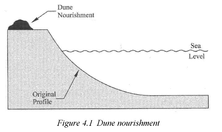
14 Sediment Management Tools Traditional (Gray) Infrastructure Jetties/groins Seawalls Breakwaters/reefs Softer approaches Beach nourishment Living shorelines Dredging Overarching Restoration of natural processes and habitats (remove dams and redesign culverts) Retreat Carlsbad Nourishment, SANDAG

15 Beach Morphology and Dynamics Parts of our beaches
16 Beach Morphology and Dynamics Seasonal cycles Summer is widest Low wave energy moves sand onshore Winter is most eroded High wave energy pulls sand to offshore bars

17 Seasonality is Variable
18 Seasonality is Variable
19 Seasonality is Variable
20 Seasonality is Variable 2017 compared to 2016 Larger waves with long period occurred in late June and early July Some of the wave events came from the south Result: Increase in mid-summer wave energy directed at Bolinas and other south-facing shores
21 Beneficial Reuse and Beach Nourishment BRBN Beneficial reuse - the application of dredged materials determined to be eligible for use in locations for enhancement, restoration, or creation of a habitat. Beach nourishment - the process of dumping or pumping sand from elsewhere onto an eroding shoreline to create a new beach or to widen the existing beach.

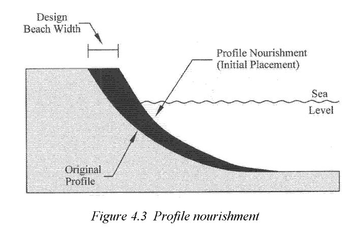
22 Methods of Beach Nourishment CA Beach Restoration Study (2002)
23 Tenets of BRBN We want: 1. Clean and compatible sediment 2. Minimal biological impacts 3. Long-lasting placement We consider: 1. Sediment sources for beach nourishment 1. Cleanliness, match, proximity 2. Potential effects on sensitive species and habitats 3. Nearshore dynamics 1. Transport pathways 2. Erosion uncertainty
24 Federal Dredged Material Programs
25 1. Clean and Compatible Sediment Federal and state required with oversight by EPA and Water Board 1. Sampling and Analysis Procedure for Beneficial Reuse of Sediment 2. Tier I Information 3. Project Description 4. Computation of Sampling and Analysis Requirements 5. Sampling Procedures 6. Physical and Chemical Testing 7. Biological Testing (if required based on results of previous tests) 8. Personnel Responsibilities
26 Contaminants and Sediment Positively-charged contaminants bind with negativelycharged clay particles Contaminant-mud colloids incorporate into flocs Flocs settle to seafloor Legend Clay particles Contaminants
27 Contaminants and Sediment Sand is not a typical carrier of contaminants Lead Sand Mud Legend Offshore site 1 Offshore site 2 Surface Area Take home message: grain size contaminants George et al, 2007
28 2. Minimal Biological Impacts Smothering Habitat conversion Loss of rocky habitat? Are those habitats naturally occurring or a product of the armoring? Addition of wrong sediment size too much mud can change from a sandy (crab) to a muddy (worm) environment
29 Beach Nourishment BMPs for Biology Wilber et al (2009), CSA (2009), Rosov et al (2016) Goal: minimize recovery times and retain similar benthic infaunal community composition 1. Avoid beach nourishment activities during peak larval recruitment 2. Complete projects prior to the natural seasonal decline 3. Use compatible sediments between the native beach and the borrow source 4. Locate borrow sites in areas that are likely to refill rapidly with beach compatible sediments
30 3. Long-lasting Placement Nearshore dynamics Seasonal cycle of beaches Erosion rates Climatic events ENSO changes Placement Specifics Volume Frequency


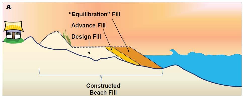
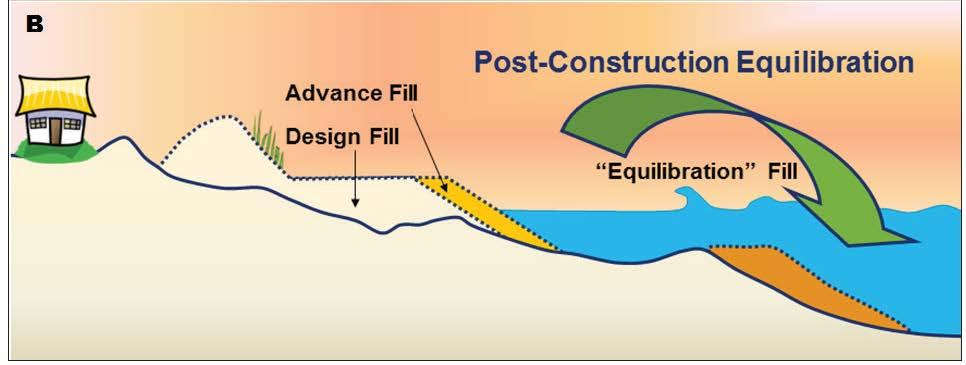
31 Where d the Placed Sand Go? Sand doesn t go away, it is stored offshore Willson et al (2017)


32 BRBN Case Study 1: Seal Beach Wildlife Refuge, Orange Co Sediment Augmentation Project in a Protected Wetland 1. Dredge Huntington Harbor 2. Analyze sediment 3. Clean mud to the wetlands 4. Clean sand to the beaches
33 BRBN Case Study 2: Ocean Beach, San Francisco Photo: SPUR City of SF and NPS (GGNRA) Sand trucking from NOB to SOB in 2012, 2014, 2016 USACE Single placement of 300,000 cubic yards Dredged sediment pumped onshore at Sloat and to 4000 south Designation as permanent site Ocean Beach Master Plan 2 million cubic yards of sand placed every 10 years from dredging SF Shipping Channel
34 Surfer s Beach Sand Replenishment Pilot Project
35 Aerial Photo of Pillar Point Harbor and Surfer s Beach
36 Project Background Construction of the East Breakwater at Pillar Point Harbor completed in 1961, resulted in increased erosion rates. 2007: community members approached Harbor District requesting action be taken. 2007: District formally requested that US Army Corps of Engineers (USACE) investigate erosion.
37 Project Background The USACE analysis determined that the bluffs along Surfer s Beach eroded at an average rate of 1.64 feet per year between 1993 and The study also found that there is a significant accumulation of sand within Pillar Point Harbor.
38

39 USACE Medium Beach Fill Design Engineering Model Results
40 Project Background USACE has since determined that there is not a federal interest in pursuing a beach nourishment project. In lieu of federal funding, the Board of Harbor Commissioners voted, in late 2015, for the District to pursue a pilot Surfer s Beach Replenishment Project.
41 Project Background February 2016: District submitted a grant application to Division of Boating and Waterways for $800,000 to fund the Project implementation (construction and monitoring). Grant request was approved and the District was notified in July 2017 that there is $800,000 in the California budget to implement the proposed pilot project.
42 Project Background April 2016: District submitted a funding request to California Ocean Protection Council (OPC) for a $75,000 Prop 84 grant to help pay for the Project Planning Phase. The OPC grant was approved in October 2016 and a grant agreement issued in June 2017, allowing the District to initiate the planning process.
43 Project Description The proposed Project involves one-time placement of approximately 75,000 cubic yards of sand. It is a Pilot project meant to study benefits and impacts. Extensive biological and physical monitoring will be included. Comprehensive planning process is now underway.
44 Project Goal and Potential Benefits The overall goal is to address the accelerated coastal erosion rates as a result of the construction of the East Breakwater. The Project will address impaired public access/recreational impacts and damages from coastal storms. Benefits include: preventing or mitigating beach erosion and sea cliff retreat; improving protection of Highway 1 and other structures; increasing quality and quantity of public access and recreation; reducing the need for coastal armoring, and improving biological habitat.
45 Proposed Project Planning Process Planning Phase includes the following components: Stakeholder collaboration and public outreach process Project design and engineering Environmental review Permitting and agency consultation Biological and physical monitoring design/planning Planning Phase now underway and will continue until project implementation, which is expected in late Summer or Fall 2018.
46 Project Implementation Phase Includes Project Construction and Biological and Physical Monitoring Construction anticipated to begin in late Summer or Fall of 2018 and take 1-3 months to complete. Project Monitoring to begin several months prior to construction and continue for up to 2-years thereafter.
47 Plans Recommending Potential BNBR at Surfer s Beach Santa Cruz Littoral Cell RSM Plan North-Central CA Coast Climate Action Plan US Army Corps of Engineers North Half Moon Bay Continuing Authorities Program (CAP) 111 Study MBNMS Management Plan Harbors and Dredge Disposal Action Plan Coastal Armoring Action Plan
48 Regulatory Setting for Conducting Beach Nourishment from Beneficial Reuse

49 Federal Dredged Material Programs
50 Agencies Likely Involved in Reviewing / Approving BRBN at Surfer s Beach FEDERAL US Army Corps of Engineers (Permit under Section 404 CWA and Section 10 RHA) US Environmental Protection Agency (review under 404 CWA) NOAA National Marine Fisheries Service (consult under MMPA and ESA/EFH under MSFMCA) U.S. Fish and Wildlife Service (consult under MMPA/ESA) STATE Central Coast Regional Water Quality Control Board (Water Quality Certification under Section 401 CWA /Porter- Cologne) CA Coastal Commission (Coastal Development Permit / consistency determination) CA Department of Fish and Wildlife (consult under CESA)
51 MBNMS Regulation that May Apply to BRBN Projects 1) Discharging or depositing, from within or into the Sanctuary, any material or other matter 2) Discharging or depositing, from beyond the boundary of the Sanctuary, any material that enters and injures a Sanctuary resource or quality 3) Drilling into, dredging or altering submerged lands... or constructing, placing, or abandoning any structure in the Sanctuary 4) Possessing, moving, removing or injuring a Sanctuary historical resource 5) Taking or possessing any marine mammal, sea turtle, or bird within or above the Sanctuary 6) Introducing or otherwise releasing introduced species
52 MBNMS Regulations MBNMS regulations prohibit permitting or approving of the disposal of dredged material except at disposal sites that were authorized by EPA prior to designation of the Sanctuary: (f) Notwithstanding paragraphs (d) and (e) of this section, in no event may the Director issue a National Marine Sanctuary permit under 15 CFR and or a Special Use permit under section 310 of the Act authorizing, or otherwise approve:...the disposal of dredged material within the Sanctuary other than at sites authorized by EPA (in consultation with COE) prior to January 1, 1993 (15 CFR (f))
53 Approval of BRBN actions under MBNMS Regulations: CAN ALLOW Placing clean non-dredged material below Mean High Water (MHW) by issuing a permit Placing clean dredged material above MHW (would not require a permit, ONMS would provide input) CANNOT ALLOW Disposing of clean dredged material below MHW
54 Handling Dredged Material (USACE and US EPA) Dredge Material Disposal Pathway ODA Analyze sediment Reuse Pathway CWA Plan for appropriate disposal Develop restoration project Upland or ocean disposal Beach nourishment action
55 CA Coastal Commission guidance on BRBN: CA Coastal Commission, Sea Level Rise Policy Guidance (August 2015): Establish a beach nourishment program and protocols Maintenance or restoration of natural sand supply Beneficial reuse of sediment through dredging management: Policies can be developed with an LCP and/or carried out through a CDP to facilitate delivery of clean sediment extracted from dredging to nearby beaches or wetland areas where needed. San Mateo County LCP Limiting Shoreline Structures on Sandy Beaches To avoid the need for future protective devices that could impact sand movement and supply, prohibit permanent structures on the dry sandy beach
56 Goal for Surfer s Beach Restore natural habitat and beach function at the site Question Should we allow beneficial reuse of dredged material (specifically the placement of sand from inside Pillar Point Harbor below MHW at Surfer s Beach)? Considerations material is tested and meets sanctuary permitting criteria & other agency requirements the project is designed to avoid impacts to sanctuary resources
57 SAC Actions MARCH 2016 GFNMS SAC recommendation: articulate a definition of beneficial reuse of clean dredged materials from harbors or other appropriate sources at the Surfer s Beach site. No MBNMS SAC recommendation received yet Seeking feedback today Recommendations from SACs at upcoming meetings
Heather Schlosser Army Corps of Engineers Coastal Studies Group August 28, 2008
 Got sand? Regional Sediment Management in Orange County Heather Schlosser Army Corps of Engineers Coastal Studies Group August 28, 2008 Regional Sediment Management Regional sediment management recognizes
memorandum Preliminary Implementation Options Overview Coastal Armor by Reach San Francisco Littoral Cell CRSMP Stakeholder Advisory Group
 550 Kearny Street Suite 900 San Francisco, CA 94108 415.262.2300 phone 415.262.2303 fax www.pwa-ltd.com memorandum date June 5, 2012 to from subject San Francisco Littoral Cell CRSMP Stakeholder Advisory
GALVESTON BAY RSM Moving toward an Integrated, Cooperative, and Holistic Approach to Estuarine Sediments
 GALVESTON BAY RSM Moving toward an Integrated, Cooperative, and Holistic Approach to Estuarine Sediments RAE Conference 2010 Larry A. Wise Moffatt & Nichol RSM is a system-based approach for collaboratively
Sunset Harbour / Huntington Harbour Maintenance Dredging and Waterline Installation Project. CMANC 21 January 2016
 Sunset Harbour / Huntington Harbour Maintenance Dredging and Waterline Installation Project CMANC 21 January 2016 County of Orange Footprint Huntington Harbour Operational and Dredging Cost Sharing Agreements
Port of Kalama, 2013 TEMCO Berth Maintenance Dredging and In-water Flow-Lane Placement Project
 2014 WEDA ENVIRONMENTAL EXCELLENCE AWARDS Category: Navigation Dredging Port of Kalama, 2013 TEMCO Berth Maintenance Dredging and In-water Flow-Lane Placement Project Port of Kalama, Washington 18 April
Regional-scale understanding of the geologic character and sand resources of the Atlantic inner continental shelf, Maine to Virginia
 Regional-scale understanding of the geologic character and sand resources of the Atlantic inner continental shelf, Maine to Virginia Workshop on Dredging, Beach Nourishment and Bird Conservation Atlantic
Planning for the Future of Humboldt Bay: Sea Level Rise, Sediment Management, Sand Spits and Salt Marshes. Joel Gerwein
 Planning for the Future of Humboldt Bay: Sea Level Rise, Sediment Management, Sand Spits and Salt Marshes Joel Gerwein Introduction to Humboldt Bay Setting Economy, community, and environment Sediment
MODELING OF EROSION CONTROL ALTERNATIVES AT STUMP PASS, CHARLOTTE COUNTY
 2014 NATIONAL CONFERENCE ON BEACH PRESERVATION TECHNOLOGY FEBRUARY 13, 2014 MODELING OF EROSION CONTROL ALTERNATIVES AT STUMP PASS, CHARLOTTE COUNTY 1 VADIM ALYMOV, PH.D. 2 CHUCK MOPPS 3 MICHAEL POFF,
MISSISSIPPI COASTAL IMPROVEMENTS
 MISSISSIPPI COASTAL IMPROVEMENTS PROGRAM (MsCIP) Comprehensive Barrier 237 27 200 237 27 200 Island 237 Restoration 27 200 Plan 80 9 27 252 74.59 255 255 255 0 0 0 63 63 63 3 32 22 239 65 53 0 35 20 2
Regional Sediment Management
 Regional Sediment Management Linda S. Lillycrop Program Manager Coastal Engineer US Army Engineer Research and Development Center Coastal and Hydraulics Laboratory Q AVG Coastal Resilience: The Environmental,
Alexandra Carvalho, Ph.D., GISP Kathy Fitzpatrick, P.E.
 Coastal Data Organization for Project Management and Coastal Planning Martin County, Florida Alexandra Carvalho, Ph.D., GISP Kathy Fitzpatrick, P.E. Outline County Coastal Programs Coastal Geodatabase
Bob Van Dolah. Marine Resources Research Institute South Carolina Department of Natural Resources
 Bob Van Dolah Marine Resources Research Institute South Carolina Department of Natural Resources Shoreline Change Will Occur! On our front beaches where it is not easy to retreat Shoreline Change Will
PG&E OFFSHORE CENTRAL COASTAL CALIFORNIA SEISMIC IMAGING PROJECT
 PG&E OFFSHORE CENTRAL COASTAL CALIFORNIA SEISMIC IMAGING PROJECT Public Scoping Meeting California State Lands Commission July 21, 2011 Project Area Project Commitments Assessment of the Hosgri, Shoreline,
Connecticut Coastal Management Program
 Connecticut Coastal Management Program Fact Sheet for SHORELINE FLOOD AND EROSION CONTROL STRUCTURES What are Shoreline Flood and Erosion Control Structures? The Connecticut General Statutes (CGS) define
Sediment Management in the Coastal Bays
 Sediment Management in the Coastal Bays Introduction Need for ecosystem view of sediment management in Coastal Bays Island loss and restoration Navigation needs Habitat Trade offs Living Shoreline Requirements
THIN-LAYER PLACEMENT OF DREDGE MATERIAL FOR MARSH NOURISHMENT, RESOTRATION, AND RESPONSE TO SEA LEVEL RISE
 THIN-LAYER PLACEMENT OF DREDGE MATERIAL FOR MARSH NOURISHMENT, RESOTRATION, AND RESPONSE TO SEA LEVEL RISE Case studies and lesson learned regarding thin-layer deposition projects in Delaware, New Jersey,
A BEACH IS A BEACH. Or Is It? Hawaii. St. Croix, US Virgin Islands
 A BEACH IS A BEACH Or Is It? Pt. Reyes, California Western Florida Hawaii AGI What is a beach? Eastern Maine A beach is a strip of shoreline washed by waves and tides. Crane Key, Florida Bay St. Croix,
ENGINEERING APPROACHES TO SHORELINE PLACEMENT FROM COAST TO COAST
 ENGINEERING APPROACHES TO SHORELINE PLACEMENT FROM COAST TO COAST 237 237 237 217 217 217 200 200 200 0 0 0 163 163 163 131 132 122 80 119 27 252 174.59 83 36 118 110 135 120 112 92 56 62 102 130 Comparing
Presentation Outline. Project Overview. Sea Level Rise Assessment & Decision Tools. Community Engagement. Tina Whitman, Friends of the San Juans
 Healthy Beaches for People & Fish Sea Level Rise Adaptation Tools for San Juan County, WA Tina Whitman & Andrea MacLennan December 10, 2015 Presentation Outline Project Overview Tina Whitman, Friends of
Seagrass Transplantation & Environmental & Marine Consulting Services, Inc. Drew Campbell, Vice President & Lead Scientst.
 Indian River Lagoon Symposium Seagrass Transplantation & Project Considerations Environmental & Marine Consulting Services, Inc. Drew Campbell, Vice President & Lead Scientst March 26 th, 2013 Regulatory
INTEGRATED COASTAL SEDIMENT MANAGEMENT AT PHYSIOGRAPHIC UNIT SCALE, AN APPLICATION IN VERSILIA LITTORAL (TUSCANY, ITALY)
") INTEGRATED COASTAL SEDIMENT MANAGEMENT AT PHYSIOGRAPHIC UNIT SCALE, AN APPLICATION IN VERSILIA LITTORAL (TUSCANY, ITALY) Damiano Scarcella (Msc) Sergio Cappucci (PhD) Andrea Taramelli (PhD) OUTLINE Sediment
INTEGRATED COASTAL SEDIMENT MANAGEMENT AT PHYSIOGRAPHIC UNIT SCALE, AN APPLICATION IN VERSILIA LITTORAL (TUSCANY, ITALY) Damiano Scarcella (Msc) Sergio Cappucci (PhD) Andrea Taramelli (PhD) OUTLINE Sediment
EAGLES NEST AND PIASA ISLANDS
 EAGLES NEST AND PIASA ISLANDS HABITAT REHABILITATION AND ENHANCEMENT PROJECT MADISON AND JERSEY COUNTIES, ILLINOIS ENVIRONMENTAL MANAGEMENT PROGRAM ST. LOUIS DISTRICT FACT SHEET I. LOCATION The proposed
Mapping of Future Coastal Hazards. for Southern California. January 7th, David Revell, Ph.D. E.
 Mapping of Future Coastal Hazards for Southern California January 7th, 2014 David Revell, Ph.D. drevell@esassoc.com E. Vandebroek, 2012 Outline Coastal erosion hazard zones Flood hazard zones: Coastal
Sea-level Rise on Cape Cod: How Vulnerable Are We? Rob Thieler U.S. Geological Survey Woods Hole, MA
 Sea-level Rise on Cape Cod: How Vulnerable Are We? Rob Thieler U.S. Geological Survey Woods Hole, MA Outline Sea-level and coastal processes Past sea-level change Predictions for the future Coastal responses
SAN FRANCISCO DISTRICT INFORMATION REQUESTED FOR VERIFICATION OF CORPS JURISDICTION
 DEPARTMENT OF THE ARMY SAN FRANCISCO DISTRICT, U.S. ARMY CORPS OF ENGINEERS 1455 MARKET STREET SAN FRANCISCO, CALIFORNIA 94103-1398 SAN FRANCISCO DISTRICT INFORMATION REQUESTED FOR VERIFICATION OF CORPS
Lower Snake River Programmatic Sediment Management Plan Final Environmental Impact Statement
 U.S. Army Corps of Engineers Walla Walla District Lower Snake River Programmatic Sediment Management Plan Final Environmental Impact Statement EXECUTIVE SUMMARY August 2014 EXECUTIVE SUMMARY Introduction
ΛTKINS. Applications of Regional Sediment Management Concepts in Texas Estuarine Restoration Projects. Riparian Workshop Fort Worth, October 17, 2012
 Juan C Moya, PhD., PG Coastal Planning and Restoration Applications of Regional Sediment Management Concepts in Texas Estuarine Restoration Projects Riparian Workshop Fort Worth, October 17, 2012 West
Naturally. Westport... Wet and Wild...
 Westport... Wet and Wild... Naturally A revitalization concept for the City of Westport and Port of Grays Harbor presented by FOGH (Friends of Grays Harbor), Wildlife Forever of Grays Harbor and other
3. MARINE HABITAT RESTORATION
 Feasibility Study for Restoration of Titlow Lagoon Fish Passage South Puget Sound Salmon Enhancement Group 3. MARINE HABITAT RESTORATION Marine habitat restoration at Titlow Park could include restoration
SEGMENTED BREAKWATERS AND THEIR USE IN COASTAL LOUISIANA
 SEGMENTED BREAKWATERS AND THEIR USE IN COASTAL LOUISIANA Prepared by: Louisiana Coastal Protection and Restoration Authority Engineering Division March 2016 The geology of Louisiana s coastal zone is intimately
Del Mar Sediment Management Study
 Del Mar Sediment Management Study Shoreline Preservation Working Group, June 7, 2018 Lindsey Sheehan Current work in Del Mar 2016 Sea-Level Rise Vulnerability Assessment 2018 Adaptation Plan 2018 Sediment
SHORELINE AND BEACH PROCESSES: PART 2. Implications for Coastal Engineering
 SHORELINE AND BEACH PROCESSES: PART 2 Implications for Coastal Engineering Objectives of the lecture: Part 2 Show examples of coastal engineering Discuss the practical difficulties of ocean engineering
Lessons Learned from Fish Spawning Reef Restoration in the St. Clair Detroit River System. Photo Credit: Adam Lintz
 Lessons Learned from Fish Spawning Reef Restoration in the St. Clair Detroit River System Photo Credit: Adam Lintz Outline and Presenters Jennifer Read, University of Michigan Water Center Introduction
Regional Sediment Management: The Long Island Coastal Planning Project
 Regional Sediment Management: The Long Island Coastal Planning Project Lynn M. Bocamazo Senior Coastal Engineer USACE-New York District 22 September 2009 US Army Corps of Engineers Outline Project Location
Engineering with Nature: Nearshore Berm Placements at Fort Myers Beach and Perdido Key, Florida, USA
 Engineering with Nature: Nearshore Berm Placements at Fort Myers Beach and Perdido Key, Florida, USA Katherine E. Brutsché, Ph.D. Research Physical Scientist ERDC-Coastal & Hydraulics Laboratory May 14,
Marine Spatial Planning: A Tool for Implementing Ecosystem-Based Management
 Marine Spatial Planning: A Tool for Implementing Ecosystem-Based Management Steven Murawski, Ph.D., Ecosystem Goal Team Lead National Oceanic and Atmospheric Administration NOAA November 16, 2009 1 To
Introduction: The Gulf of Mexico Alliance. The Gulf GAME project MERMAid and PHINS Results & Conclusions What s next? Examples
 AAG Las Vegas March 25, 2009 Introduction: Ocean governance and Ecosystem-Based Management The Gulf of Mexico Alliance Habitat Identification and Characterization The Gulf GAME project MERMAid and PHINS
Modeling dispersal kernals with limited. information. Douglas T. Fischer, Louis W. Botsford, David M. Kaplan, J. William White, John Largier
 Modeling dispersal kernals with limited http://www.nmfs.noaa.gov/habitat/ habitatprotection/profile/pacificcouncil.htm information Douglas T. Fischer, Louis W. Botsford, David M. Kaplan, J. William White,
CHAPTER 3. Coastal Processes and Human Adaptations
 CHAPTER 3 Coastal Processes and Human Adaptations This Chapter examines the Oceanside Littoral Cell along with implications of human intervention, including sediment management, beach nourishment and the
HAWAII REGIONAL SEDIMENT MANAGEMENT
 HAWAII REGIONAL SEDIMENT MANAGEMENT KAUAI Workshop January 20, 2011 Kauai Veteran s Center Kihei, HI of Engineers, Honolulu District AGENDA 1300-1310 Welcome and Introductions Conger Conant 1310-1330 Regional
Solutions to Flooding on Pescadero Creek Road
 Hydrology Hydraulics Geomorphology Design Field Services Photo courtesy Half Moon Bay Review Solutions to Flooding on Pescadero Creek Road Prepared for: San Mateo County Resource Conservation District
A SEDIMENT BUDGET ANALYSIS AND MANAGEMENT STRATEGY FOR FORT PIERCE INLET, FL
 A SEDIMENT BUDGET ANALYSIS AND MANAGEMENT STRATEGY FOR FORT PIERCE INLET, FL By Elba Rodriguez and Robert G. Dean Department of Civil and Coastal Engineering University of Florida Gainesville, FL 32611,
Cross Boundary Issues
 6 Cross Boundary Issues 6 C R O S S B O U N D A R Y I S S U E S 6.1 Introduction The effects of an activity within the coastal marine area are often felt in adjacent areas, outside of the immediate vicinity
Materials. Use materials meeting the following.
 208.01 Section 208. SOIL EROSION AND SEDIMENTATION CONTROL 208.01 Description. Install and maintain erosion and sedimentation controls to minimize soil erosion and to control sedimentation from affecting
Material Workshop. Galveston District 2012 Beneficial Use of Dredged. Material Workshop. Custodians of the Coast
 Galveston District 2012 Beneficial Use of Dredged Material Workshop Galveston District 2012 Beneficial Use of Dredged Material Workshop US Army Corps of Engineers BUILDING STRONG Welcome Opening Remarks
Coastal Processes and Shoreline Erosion on the Oregon Coast, Cascade Head to Cape Kiwanda
 State of Oregon Department of Geology and Mineral Industries Vicki S. McConnell, State Geologist Open File Report OFR O-04-11 Coastal Processes and Shoreline Erosion on the Oregon Coast, Cascade Head to
ENGINEERING WITH NATURE: NEARSHORE BERM PLACEMENTS AT FORT MYERS BEACH AND PERDIDO KEY, FLORIDA, USA
 1 ENGINEERING WITH NATURE: NEARSHORE BERM PLACEMENTS AT FORT MYERS BEACH AND PERDIDO KEY, FLORIDA, USA KATHERINE E. BRUTSCHÉ 1, PING WANG 2, JULIE D. ROSATI 1, CHERYL E. POLLOCK 1 1. U.S. Army Engineer
Subcommittee on Sedimentation Draft Sediment Analysis Guidelines for Dam Removal
 Subcommittee on Sedimentation Draft Sediment Analysis Guidelines for Dam Removal August 4, 2011 Jennifer Bountry, M.S., P.E. Tim Randle, M.S., P.E., D.WRE. Blair Greimann, Ph.D., P.E. Sedimentation and
Supplemental Slides. Shore: Junction of Land & Water. Junction of Land & Water. Sea Level Variations. Shore vs. Coast. Sea Level Variations
 Shore: Junction of Land & Water Supplemental Slides Sediments come off land Most get dumped at the beach Sediment interacts with ocean waves and currents Junction of Land & Water Features: Breaking waves,
Shore: Junction of Land & Water. Sediments come off land Most get dumped at the beach Sediment interacts with ocean waves and currents
 Shore: Junction of Land & Water Supplemental Slides Sediments come off land Most get dumped at the beach Sediment interacts with ocean waves and currents Junction of Land & Water Features: Breaking waves,
West Galveston Bay Regional Sediment Management Plan (An Eco-geomorphologic Approach)
") West Galveston Bay Regional Sediment Management Plan (An Eco-geomorphologic Approach) Juan Moya, Matthew Mahoney and Mike Smith Restore America s Estuaries Conference Tampa, FL, October 23, 2012 Atkins
West Galveston Bay Regional Sediment Management Plan (An Eco-geomorphologic Approach) Juan Moya, Matthew Mahoney and Mike Smith Restore America s Estuaries Conference Tampa, FL, October 23, 2012 Atkins
Fish and Fish Habitat Follow-up Program. Scotian Basin Exploration Project
 Fish and Fish Habitat Follow-up Program Scotian Basin Exploration Project April 2018 Contents 1 Introduction... 1 2 Scope... 1 3 EIS Commitments and Predictions... 2 4 Methodology and Reporting... 2 4.1
Application #: TEXT
 TOWN OF FORT MYERS BEACH 2008 PROPOSED COMPREHENSIVE PLAN AMENDMENTS Application #: 2008-13-TEXT Description: Modify the Coastal Management and Future Land Use Elements to reflect the state s new definition
DIVISION OF COASTAL MANAGEMENT TO STUDY CURRENT LONG-TERM EROSION RATES ADJACENT TO TERMINAL GROINS
 DIVISION OF COASTAL MANAGEMENT TO STUDY CURRENT LONG-TERM EROSION RATES ADJACENT TO TERMINAL GROINS North Carolina Department of Environmental Quality Division of Coastal Management February 22, 2018 N.
BOEM Marine Minerals Program
 BOEM Marine Minerals Program Restoring and Protecting Our Nation s Coasts through Stewardship of OCS Sand Resources SECOORA 2018 Annual Meeting May 22-24 Doug Piatkowski Douglas.piatkowski@boem.gov 703-787-1833
Coastal Sediment Properties and Longshore Sediment Transport
 Coastal Sediment Properties and Longshore Sediment Transport Julie Rosati Julie.D.Rosati@erdc.usace.army.mil 601-634-3005 Coastal Planning Course Lesson #8 Tuesday 8:00-9:00 am CEM III-1, III-2 1. Coastal
Draft exercise for share fair at Bozeman workshop only. This exercise is not ready for distribution. Please send helpful suggestions to
 Draft exercise for share fair at Bozeman workshop only. This exercise is not ready for distribution. Please send helpful suggestions to foleyd@plu.edu Figure list 1. Trailer photograph 2. Location map
Marine Spatial Data for Marine Spatial Planning. Ocean Leadership 2010 Public Policy Forum
 Marine Spatial Data for Marine Spatial Planning Ocean Leadership 2010 Public Policy Forum March 10, 2010 Edward Saade President, Fugro EarthData, Inc 1 Marine Spatial Data What is Marine Spatial Data?
Coastal Environment. Introduction. 4.1 Coastal Environment. Extent of Coastal Environment
 4 The primary objective (set out in Chapter 2) to be implemented by this Chapter is Objective 2.4 ; the following objectives are also relevant due to the objectives integrated nature: 2.1 Tāngata whenua
The U.S. Army Corps of Engineers Philadelphia District
 The U.S. Army Corps of Engineers Philadelphia District The Atlantic Coast of New Jersey Regional Sediment Budget 1986-2003 Cape May Point to Manasquan Inlet Final Report March 2006 The Atlantic Coast of
Oyster Reef for Shoreline Stabilization and Restoration. Jason Kirkpatrick Conservation Program Manager MacDill AFB Tampa, Florida
 Oyster Reef for Shoreline Stabilization and Restoration Jason Kirkpatrick Conservation Program Manager MacDill AFB Tampa, Florida Interbay Penninsula Port of Tampa X The few remaining mangroves are being
The Use of Geographic Information Systems to Assess Change in Salt Marsh Ecosystems Under Rising Sea Level Scenarios.
 The Use of Geographic Information Systems to Assess Change in Salt Marsh Ecosystems Under Rising Sea Level Scenarios Robert Hancock The ecological challenges presented by global climate change are vast,
Coastal issues: Beaches and Estuaries
 Coastal issues: Beaches and Estuaries Definitions: Coast = broad zone where both marine & terrestrial processes act It includes the beach, lagoons, marshes, bars etc. Coastal processes act to shape the
Sri Lanka has a coastline of km excluding the shoreline of bays and inlets.
 Defining and Demarcating Coastal zones in Sri Lanka Procedure, Challenges and What needs to be done? Dr. Anil Premaratne Director General Coast Conservation Coast Conservation Department Sri Lanka 1 Sri
Special Public Notice
 Special Public Notice Applicability: General Public Date: June 3, 2014 The purpose of this public notice is to inform you of existing guidance and policy contained in Regulatory Guidance Letter 05-04 concerning
Relatively little hard substrate occurs naturally in the
 CHAPTER FIVE Rock Habitats Relatively little hard substrate occurs naturally in the estuary, owing mainly to the vast quantities of fine sediment that have been deposited by the rivers. Rock habitat is
Understanding coastal erosion in Alaska
 Understanding coastal erosion in Alaska Alaska Center for Climate Assessment and Policy Statewide Teleconference October 9, 2007. David E. Atkinson International Arctic Research Center / Atmospheric Science
The Marine Environment
 The Marine Environment SECTION 16.1 Shoreline Features In your textbook, read about erosional landforms, beaches, estuaries, longshore currents, and rip currents. For each statement below, write true or
In-channel coarse sediment trap Best Management Practice
 In-channel coarse sediment trap Best Management Practice By Henry R. Hudson July 2002 Environmental Management Associates Ltd., Christchurch Complexity Environmental Value Cost Low Moderate High Low Moderate
Erosion Information Paper - Barrow, Alaska Current as of September 14, 2007
 U.S. Army Corps of Engineers ALASKA BASELINE EROSION ASSESSMENT Erosion Information Paper - Barrow, Alaska Current as of September 14, 2007 Community Information Barrow (BARE-row, a.k.a. Ukpeagvik), population
Coastal Inlets Research Program US Army Corps of Engineers Engineering Research and Development Center
 Coastal Inlets Research Program US Army Corps of Engineers Engineering Research and Development Center Site of Moriches Inlet Nov. 1951 Julie Dean Rosati and Nicholas C. Kraus, CIRP Program Manager Shinnecock
MEMORANDUM FOR SWG
 MEMORANDUM FOR SWG-2007-1623 Subject: Jurisdictional Determination (JD) for SWG-2007-1623 on Interdunal Wetlands Adjacent to Traditional Navigable Waters (TNWs) Summary The U.S. Environmental Protection
Geol 117 Lecture 18 Beaches & Coastlines. I. Types of Coastlines A. Definition:
 I. Types of Coastlines A. Definition: 1. Shore = narrow zone where ocean meets land (e.g. beach) 2. Coast is a broad area where both ocean and land processes act a. Includes onshore marshes, dunes, sea
DRAFT FINAL: AUGUST 4, 2017
 DRAFT FINAL: AUGUST 4, 2017 DRAFT MARCH 27, 2017 DRAFT FINAL CALIFORNIA REGIONAL ASSESSMENT NATIONAL SHORELINE MANAGEMENT STUDY ii Prepared by: Rachel Grandpre U.S. Army Corps of Engineers Institute of
Elwha River response to dam removals through four years and a big flood:
 Elwha River response to dam removals through four years and a big flood: Lessons learned, channel response, and sediment effects from the world s largest engineered dam removal Andy Ritchie NPS Elwha Restoration
Sea Level Rise and the Public Trust Doctrine:
 Sea Level Rise and the Public Trust Doctrine: Meeting Coastal Governance Challenges in the Face of Climate Change www.remote.ucdavis.edu Department ofwater Resources www.rwongphoto.com Jennifer DeLeon
NOAA Nautical Charts and Coastal and Marine Spatial Planning. Meredith Westington Chief Geographer NOAA/NOS/Office of Coast Survey
 NOAA Nautical Charts and Coastal and Marine Spatial Planning Meredith Westington Chief Geographer NOAA/NOS/Office of Coast Survey Ocean Policy Task Force What is CMSP? A comprehensive, adaptive, integrated,
Geology Setting Management Options Management Structure
 Geology Setting Management Options Management Structure WFF = Wallops Flight Facility LST = Longshore sediment transport SLR = Sea level rise September 29, 2015 Accomack County/Accomack Northampton County
Lower 8.3 Miles of the Lower Passaic River Operable Unit 2 Presentation to The Passaic River Community Advisory Group. September 14, 2017
 Lower 8.3 Miles of the Lower Passaic River Operable Unit 2 Presentation to The Passaic River Community Advisory Group September 14, 2017 Agenda Pre-Design Investigation (PDI) Status Geophysical, Bathymetric,
Lab 12 Coastal Geology
 Lab 12 Coastal Geology I. Fluvial Systems Hydrologic Cycle Runoff that flows into rivers = precipitation (rain and snowmelt) [infiltration (loss to groundwater) + evaporation (loss to atmosphere) + transpiration
The Coastal Field Data Collection Program (CFDC) Waves & Coastal Observations for the Corps and the Nation
 Waves & Coastal Observations for the Corps and the Nation") The Coastal Field Data Collection Program (CFDC) Waves & Coastal Observations for the Corps and the Nation Bill Birkemeier Program Manager William.Birkemeier@usace.army.mil 10 August 2010 US Army Corps
The Coastal Field Data Collection Program (CFDC) Waves & Coastal Observations for the Corps and the Nation Bill Birkemeier Program Manager William.Birkemeier@usace.army.mil 10 August 2010 US Army Corps
The Marine Environment
 The Marine Environment SECTION 16.1 Shoreline Features In your textbook, read about erosional landforms, beaches, estuaries, longshore currents, and rip currents. For each statement below, write or. 1.
COASTAL PROTECTION MEASURES & MANAGEMENT STRATEGY FOR SOUTH OCEAN BEACH
 COASTAL PROTECTION MEASURES & MANAGEMENT STRATEGY FOR SOUTH OCEAN BEACH Ocean Beach Master Plan: Coastal Management Framework Prepared for April 24, 2015 San Francisco Public Utilities Commission Under
Response Case Study: April 2014 Historic Flood Event. Severe Weather April 29 30, 2014
 Response Case Study: April 2014 Historic Flood Event NOAA s Regional Preparedness Training (NRPT) Natural Disaster Causing Technology Disasters in Mobile Bay Area Kimberly Albins Gulf of Mexico Regional
Biogeographic Approach to Coastal Assessments & Spatial Planning
 NOAA s Biogeographic Approach to Coastal Assessments & Spatial Planning Mark E. Monaco Mark.Monaco@noaa.gov Center for Coastal Monitoring and Assessment http://ccma.nos.noaa.gov/about/biogeography Biogeography
BEFORE THE ENVIRONMENTAL PROTECTION AUTHORITY AT WELLINGTON
 BEFORE THE ENVIRONMENTAL PROTECTION AUTHORITY AT WELLINGTON IN THE MATTER of the Exclusive Economic Zone and Continental Shelf (Environmental Effects) Act 2012 (EEZ Act) AND IN THE MATTER BETWEEN AND AND
Highland Lake Bathymetric Survey
 Highland Lake Bathymetric Survey Final Report, Prepared For: The Town of Highland Lake 612 Lakeshore Drive Oneonta, AL 35121 Prepared By: Tetra Tech 2110 Powers Ferry Road SE Suite 202 Atlanta, GA 30339
RESULTS FROM THE TEXAS COASTAL SEDIMENT SOURCES: A GENERAL EVALUATION STUDY
 RESULTS FROM THE TEXAS COASTAL SEDIMENT SOURCES: A GENERAL EVALUATION STUDY JUAN MOYA KELSEY CALVEZ CRIS WEBER ANTHONY RISKO *KEVIN FRENZEL FREESE AND NICHOLS, INC. COASTAL AND WATERWAYS GROUP OBJECTIVES
A process-based approach toward assessing the coastal impact of projected sea level rise and severe storms
 A process-based approach toward assessing the coastal impact of projected sea level rise and severe storms Patrick Barnard 1, Cheryl Hapke 2, Li Erikson 1, Amy Foxgrover 1, and Maarten van Ormondt 3 1
NEWS RELEASE UNDER SECTION 404 OF THE CLEAN WATER ACT (33 USC 1344) ACTION NUMBER SPA ABQ
 ACTION NUMBER SPA ABQ") PUBLIC NOTICE Public Notice Issue Date: //6/07 Albuquerque District Comments due: /6/08 NEWS RELEASE UNDER SECTION 0 OF THE CLEAN WATER ACT ( USC ) ACTION NUMBER SPA-06-00-ABQ BANK STABILIZATION ALONG
PUBLIC NOTICE Public Notice Issue Date: //6/07 Albuquerque District Comments due: /6/08 NEWS RELEASE UNDER SECTION 0 OF THE CLEAN WATER ACT ( USC ) ACTION NUMBER SPA-06-00-ABQ BANK STABILIZATION ALONG
Randall W. Parkinson, Ph.D., P.G. Institute of Water and Environment Florida International University
 An Update on Adaptation Action Activities Undertaken Since Completion of the City of Satellite Beach (FL) Vulnerability Assessment to Rising Seas (2010) Randall W. Parkinson, Ph.D., P.G. Institute of Water
Primer on Coastal Erosion And Habitat Creation
 2 nd Regional Conference Dredging, Beach Nourishment & Bird Conservation Primer on Coastal Erosion And Habitat Creation Timothy Kana Ph.D Source: Newsday 1962 Photo by Kelsey Aerials 1978 Source: U Mass
Version TNW Only 1 of 3
 APPROVED JURISDICTIONAL DETERMINATION FORM U.S. Army Corps of Engineers SECTION I: BACKGROUND INFORMATION A. REPORT COMPLETION DATE FOR APPROVED JURISDICTIONAL DETERMINATION (JD): 3 Mar 2009. B. DISTRICT
Summer 2014 Reading the Geologic History of Doheny State Beach Rodger More LAYERS LET S TAKE A TOUR THE BLUFFS
 Summer 2014 Reading the Geologic History of Doheny State Beach Rodger More DSBIA Board Officer and Geologist (retired) LAYERS of sediment and rock are like a book. Formations make up chapters and individual
Coastal Processes 101. Greg Berman (Woods Hole Sea Grant & Cape Cod Cooperative Extension)
") Coastal Processes 101 Greg Berman (Woods Hole Sea Grant & Cape Cod Cooperative Extension) January 23, 2019 Coastal Processes 101 Outline: ~30 min talk Coastal Processes What is Erosion? Value of the Ecosystem
Coastal Processes 101 Greg Berman (Woods Hole Sea Grant & Cape Cod Cooperative Extension) January 23, 2019 Coastal Processes 101 Outline: ~30 min talk Coastal Processes What is Erosion? Value of the Ecosystem
SAVANNAH HARBOR EXPANSION BANK EROSION STUDY UPDATE
 CESAS-EN-GS SAVANNAH HARBOR EXPANSION BANK EROSION STUDY UPDATE GEOTECHNICAL AND HTRW BRANCH SOILS SECTION CITY FRONT, BIGHT SECTION, FORT PULASKI & NORTH TYBEE ISLAND GEORGIA 23 June 2011 CESAW-TS-EG
Beach Nourishment on the Florida East Coast. Boca Raton
 Beach Nourishment on the Florida East Coast Past Future Boca Raton Erosion is the Main Reason for Beach Past - Erosion on the east coast was mainly caused by inlets created or modified for navigation Nourishment
Coastal Barrier Island Network (CBIN): Management strategies for the future
: Management strategies for the future") Coastal Barrier Island Network (CBIN): Management strategies for the future Heather Joesting*, Amy Williams**, Rusty Feagin**, and William K. Smith* *Department of Biology, Wake Forest University, Winston
Coastal Barrier Island Network (CBIN): Management strategies for the future Heather Joesting*, Amy Williams**, Rusty Feagin**, and William K. Smith* *Department of Biology, Wake Forest University, Winston
Cliff stabilisation. Adaptation Option Climate-ADAPT
 Cliff stabilisation Adaptation Option Climate-ADAPT Cover design: EEA Cover photo: EEA Layout: EEA Legal notice The contents of this publication do not necessarily reflect the official opinions of the
Nearshore Placement as a Regional Sediment Management Practice
 Nearshore Placement as a Regional Sediment Management Practice Katherine E. Brutsché, Ph.D. Brian C. McFall, Ph.D., P.E. Coastal and Hydraulics Laboratory US Army Engineer R&D Center ASBPA National Coastal