Basic Land Navigation. Clark County Sheriff Core Comp Rev. # Land Navigation
|
|
|
- Austin Douglas
- 5 years ago
- Views:
Transcription


1 Basic Land Navigation Clark County Sheriff Core Comp Rev. # Land Navigation
2 Requirement Through written evaluation the applicant will demonstrate knowledge of land navigation involved in Search and Rescue in the State of Washington. Classroom - Performance Criteria 1. Identify the different types of maps used in SAR. 2. Identify the primary coordinate systems in use today. 3. Identify a location on a map using Latitude and Longitude (degrees minutes - decimal minutes). 4. Identify a location on a map using UTM. 5. Define the difference between True and Magnetic north. 6. Identify the relevance of Datum and coordinate systems 7. Identify the advantages and limitations of GPS. 8. Define several advantages and disadvantages of the different map coordinate systems. 9. Determine the elevation of a point on a map. 10. The coordinate system most commonly used by aircraft and maritime vessels. 11. Identify 10 common map symbols. 12. Identify the components of a compass.
3 Requirement Field - Performance Criteria Through performance evaluation, the applicant will demonstrate the ability to (These Field Performance Criteria Must be performed in a field setting Proficiency Must Be Demonstrated) Numbers 11 thru 12 - Do Not Apply to Support or Limited Field Responders. 1. Orient a map, compensating for declination. 2. Use a scale to measure distance on a map. 3. Identify five elements of the legend on a topographic map. 4. Read contour lines on a topographic map and identify their relationship to physical objects on the ground. 5. Plot a bearing on a map. 6. Plot their location using a map and compass 7. Determine the bearing between two points and the back azimuth on a map. 8. Adjust for declination (compass). 9. Demonstrate the ability to take a bearing on a selected object, expressing it in both true and magnetic degrees (compass). 10. Plot a coordinate using the primary coordinate system in your area of operation (lat/long, UTM, National Grid). 11. Demonstrate the ability to navigate between four (4) selected points in your primary search area for a minimum distance of.5 mile (or 1/2 mile) with no more than four (4) (+/- 2) degrees of deviation (using the appropriate tools, i.e. compass, map, GPS). 12. Demonstrate the ability to navigate around an obstacle blocking your selected path while staying on course (compass).
4 MAPS Topographical Maps Street Maps Aerial/Satellite Maps USGS Maps Several types of maps are used in Land Navigation There are others as well, however for most Law Enforcement purposes, these are the most commonly used.
5 Topographical Maps A graphical representation of an area on the planet that shows all of the contours of a given area They can be very detailed They are packed with useful information They are the most common map used in Land Navigation

6 Street Maps Street maps are the second most common map used They too can be packed full of useful information and some are often a hybrid of Street/Topo map

7 Satellite/Aerial View Maps Very useful for the Command post to get a Big Picture idea Used also in conjunction with Topo Maps to put a birds eye view on the area Can be accessed via most Smart Phones if internet access is available Google maps app.

8 Basic Tools Needed for Navigation GPS Map & Compass Tools PENCIL 1 2 N MAP W N E WATERPROOF MAP CARRIER S CARD COMPASS 270PROTRACTOR 90 RULER String
9 GPS The GPS has become the choice for Navigation over Map and Compass The GPS should however, NEVER be depended as the sole form of Navigation It compliments the Map & Compass It is battery operated and can be effected by the weather and terrain
10 GPS Advantages Powerful tool that can carry many maps Give easy guidance Easy way to track your movements Disadvantages It is an electronic device out in the woods Accuracy can be effected by weather and terrain Battery operated Can be dropped or broken

11 Map & Compass The Map and Compass MUST be used together for successful Land Navigation Map and Compass work are a very perishable skills and MUST be practiced often In the woods is not the time to Wish you would have practiced more
12 Map & Compass Accessories You Should assemble a basic Land Nav kit A few items to compliment your Navigation Kit and make life easier PENCIL 1 2 Waterproof Map case N MAP W N E Pencil Protractor WATERPROOF MAP CARRIER S CARD COMPASS 270PROTRACTOR RULER 4 Ruler String (for measuring curves)


13 Map and Compass Accessories Waterproof case is essential $ $50.00 Buy a nice case to hold Map and accessories In a pinch a Ziploc bag works well

14 Protractors Many different types of Protractors Most do the same things it is really a personal preference The cost is usually a few dollars

15 Protractors Cont Assist you with Plotting of routes and bearings Can be used as rulers for measuring distance Will often have various map scale grid rulers

16 Pencil Dry Erase Pen Fine Tip Sharpie Use the pencil for making initial plotting's on the map Use the Dry erase marker on the Map Case or Ziploc Use the Fine tip Sharpie for making permanent marks
17 Pace Count Beads Used to measure travelling by you pace count. $10.00
18 MAPS They come in various sizes and scales The most common we will use will be the 1:24,000 1 inch on the map = 24,000 inches on the ground, or about 2000 feet This is the most used scale as it gives you the most amount of detail in a scale you can work with on a single sheet of paper
19 Coordinate Systems There are several in use today UTM Universal Transverse Mercator UTM is the Primary system used in Land SAR Latitude and Longitude Lat/Long is the primary system used by Aircraft and Maritime USNG United States National Grid Very similar to UTM and Military grid
20 Differing Coordinate Systems Advantages/Disadvantages Using latitude and longitude is good if you're navigating over Long distances such as when flying a plane or navigating a ship. But for people using maps to navigate for short distances, latitude and longitude are impractical. For land Navigation, the grid system most commonly used is the UTM system. The UTM system was developed by the military during World War Ifor long range military artillery, but its practicality for any type of land navigation soon made it the universal standard for all military uses, and it quickly migrated to non military use.
21 DATUM DATUM is a reference from which measurements are made. In Surveying, adatumis a set of reference points on the Earth's surface against which position measurements are made and (often) an associated model of the shape of the Earth to define a geodetic coordinate system. Horizontal DATUM S are used for describing a point on the Earth s surface, in Latitude and Longitude, UTM, or other coordinate systems.
22 DATUM Types Known as Datum Adjustments or Epochs WGS84 NAD27 Original NAD83 = NAD83 (1986) NAD83 (1992) NAD83 (2002) Most Current NAD83 NAD83 (CORS96) (Epoch )
23 Coordinate systems and DATUM There are different Coordinate systems and Different DATUM S To work effectively in the field and with SAR base, everyone at SAR Base and in the field need to be on the same Coordinate system and DATUM. If not, then locations could be off by many feet or yards or further..

24 Map Scale Will tell you the map size, Contour intervals, and a scale ruler usually in Miles feet meters - Kilometers

25 Contour Lines One of the advantages to using a topographical map is that it shows the three dimensional lay of the land. It does this by using contour lines. A contour line is a line that connects points of equal elevation. On the topo map they appear as the brown lines

26 Map Terrain Feature Ridgeline: A ridgeline is a line of high ground, usually with changes in elevation along its top and low ground on all sides
27 Map Terrain Feature Hill: A hill is an area of high ground. From a hilltop, the ground slopes down in all directions
28 Map Terrain Feature Saddle: A saddle is a dip or low point between two areas of higher ground.

29 Map Terrain Feature Valley: A valley is a stretched-out groove in the land, usually formed by streams or rivers. A valley begins with high ground on three sides, and usually has a course of running water through it

30 Map Terrain Feature Ridge: A ridge is a sloping line of high ground. If you are standing on the centerline of a ridge, you will normally have low ground in three directions and high ground in one direction with varying degrees of slope.

31 Map Terrain Feature Depression: A depression is a low point in the ground or a sinkhole. It could be described as an area of low ground surrounded by higher ground in all directions, or simply a hole in the ground

32 Map Terrain Feature Spur: A spur is a short, continuous sloping line of higher ground, normally jutting out from the side of a ridge

33 Map Terrain Feature Draw: A draw is a less developed stream course than a valley. In a draw, there is essentially no level ground and, therefore, little or no maneuver room within its confines

34 Map legends There are many styles of map symbols. Get familiar with the ones that are used in your area Here are just a few.


35 Contour lines Campground

36 The Compass There are Numerous brands of Compass available As with all things you get what you pay for A dependable and accurate compass will cost about $30.00 Recommended brands are Silva and Suunto Must have adjustable Declination

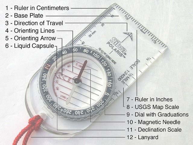
37 Parts of the Compass
38 True North Vs. Magnetic North True North: Also known as Geographic North or Map North, is the geographic north pole where all longitude lines meet. All maps are laid out with true north directly at the top. Magnetic North: Think of the earth as a giant magnet. However, the earth's magnetic field is inclined at about 11 from the axis of rotation of the earth, so this means that the earth's magnetic pole doesn't correspond to the Geographic North Pole and because the earth's core is molten, the magnetic field is always shifting slightly. The red end of your compass needle is magnetized and wherever you are, the earth's magnetic field causes the needle to rotate until it lies in the same direction as the earth's magnetic field. This is magnetic north (marked as MN on a topographic map
39 True and Magnetic North True North is the direction along the earth's surface towards the geographic North Pole. Magnetic North the direction a compass points toward the Magnetic North Pole For basic Navigation, and to have your map work in harmony with your compass, aknowledge of how to use Declination is essential

40 Magnetic Declination The symbol is used in conjunction with a compass for navigational purposes. The center line with the star above represents the direction of true geographic north. For east declination the line coming off to the right represents the direction of magnetic north, When using a compass, the needle always points to magnetic north. The symbol tells you that for the area the map covers, the magnetic compass needle will always point 19 degrees to the east of true geographic north.
41 Magnetic Declination cont.. This chart shows a rough idea of the effect of Magnetic Declination in the US. The amount of declination changes slightly over time as the earth shifts its magnetic center.

42 Setting Declination on the compass If you spent the few extra dollars and bought a compass with Declination adjustment, you are set.

43 Boxing the Compass Needle When you get out in the field and begin to maneuver the bearings you have set, it is important to hold the compass consistently and to keep the Red arrow Boxed.
44 Metals effects on the compass Metal objects will affect the accuracy of your compass When navigating with the compass keep them away from your body If you have metal rings on, remove it or keep that hand away from the compass Ore deposits in the earth will also affect the compass. IE the lava fields up on Mt. St. Helens

45 Latitude and Longitude The Earth is divided into a grid LATITUDE lines run East to West LONGITUDE lines run North to South
46 Lat/Long cont.. To precisely locate points on the earth's surface, degrees longitude and latitude have been divided into minutes (') and seconds ("). Each Degree is about 69 miles in distance. There are 60 minutes in each degree. Each minute is divided into 60 seconds. Seconds can be further divided into tenths, hundredths, or even thousandths. Lat/Long is primarily used by Pilots and Mariners now as it is best for plotting long distance travel.

47 Lat/Long Example Clark County Safety Complex 45º N 122º W
48 Lat/long Vs. UTM Both are very accurate It is really a Ford Vs. Chevy mentality Both are read pretty much the same way in that there is a point on the map indicating a location. This location can be found by intersecting a Line running North and South by a line running East and West Whether you use Lat/Long lines or UTM grids, the result will be the same, as long as all teams and base are using the same coordinate system and datum.
49 UTM is Born The Universal Transverse Mercator projection and grid system was adopted by the U.S. Army in 1947 for designating rectangular coordinates on large scale military maps. UTM is currently used by the United States and NATO armed forces. With the advent of inexpensive GPS receivers, many other map users are adopting the UTM grid system for coordinates that are simpler to use than latitude and longitude
50 UTM UTM zones are numbered 1 through 60, starting at the international date line, longitude 180, and proceeding east. Zone 1 extends from 180 W to 174 W and is centered on 177 W. Each zone is divided into horizontal bands spanning 8 degrees of latitude. These bands are lettered, south to north, beginning at 80 S with the letter C and ending with the letter X at 84 N. The letters I and O are skipped to avoid confusion with the numbers one and zero. The band lettered X spans 12 of latitude. This is the Primary Coordinate system used in Land SAR

51 UTM World Map


52 UTM Zones For The Continental US 11-U UTM Zones For The Continental US 10-U 12-U 13-U 14-U 15-U 16-U 17-U 18-U 19-U 20-U 10-T 11-T 12-T 13-T 14-T 15-T 16-T 17-T 18-T 19-T 10-S 11-S 12-S 13-S 14-S 15-S 16-S 17-S 18-S 11-R 12-R 13-R 14-R 15-R 16-R 17-R
53 UTM A square grid is superimposed on each zone. It's aligned so that vertical grid lines are parallel to the center of the zone, called the central meridian. UTM grid coordinates are expressed as a distance in meters to the east, referred to as the "easting", and a distance in meters to the north, referred to as the "northing".
54

55

56
57 How Reading UTM Works
58
59 Easting Easting will read
60 Northing will read Northing


61 Into the CP your Coordinates would read Easting and Northing Northing Easting
62 Finding a UTM coordinate # E N
63 X
64 Finding a UTM coordinate # E N
65 X
66 Finding a UTM coordinate # E N
67 X
68 Finding a UTM coordinate # E N
69 X
70 Finding a UTM coordinate # E N
71 X
72 Bearings Getting from point A to point B You can do this in the pre-planning stages which is preferable Or you can do it in the field as long as you know your current position and can mark it on the map
73 You are here
74 You are here You want to go here
75 You want to go here Draw a straight line between them You are here


76 Place the edge of your compass along The line you have drawn You want to go here You are here
77 Next rotate the Bezel until the Meridian lines match North on the Map Once aligned read the degrees on The bezel and that is your bearing You want to go here You are here

78 Bearings cont.. A properly aligned compass on a Map to determine Bearing. The meridian lines in the base plate are parallel with the map grid lines.
79 Measuring Distance Now you know where you want to go and the bearings to get there Next you have to figure out how far it is Using the scale on the bottom of the map you can easily measure the straight line distance between the two points Your protractor or UTM guide is the perfect way to measure that distance If you don t have one any straight edge will do as long as you can mark the scale from the legend onto it Using a piece of string to follow the curves of a stream, trail, or road.

80 Using a protractor or any straight edged device measure point A to B and use the scale BLANK X Point B Point A

81 Measuring cont.. Improvising is OK. Use a small ruler, piece of paper, whatever, and line it up with the Scale at the bottom of the map and make your own marks on it.

82 Measuring cont.. Use your improvised measuring tool to work the bearing line on your map

83 Measuring cont.. The improvised ruler was able to get most of the Bearing line measured accurately. Use your Grid Ruler to get the last bit of line measured with accuracy.
84 Navigating around obstacles There will be times when unexpected obstacles will appear in your path You may have plotted your course perfectly. BUT Maps are not always current. They may not reflect seasonal lakes, streams or rivers A recent storm may have blown down a lot of trees directly in the past you need to navigate
85 You want to go here X Obstruction X Remember where you are at on your pace count. Post a man or an object to where you plan to deviate. Post a man on the other side of the obstruction in line with bearing. Turn 90 degrees and walk until you pass the obstruction You are here
86 You want to go here X Obstruction X When you clear the obstruction, turn back 90 degrees and resume pace count until you pass the obstruction You are here
87 You want to go here X Obstruction X Stop pace count and turn 90 degrees back to your original bearing. Make sure you line up your bearing with both posted known reference points You are here
88 Practical Exercise's Using your Map Compass UTM Grid square Ruler We will plot a start point and a destination We will determine the Bearing and Distance between the two
89 Problem #1 Plot the Following UTM Coordinates Starting Point E N Destination E N Determine the Bearing Determine the distance

90 Bearing is 55 Degrees NE Distance is 2000 meters Dest Start
91 Problem #2 Plot the Following UTM Coordinates Starting Point E N Destination E N Determine the Bearing Determine the distance

92 Bearing is 126 Degrees SE Distance is 3100 Meters Start Dest
93 Problem #3 Plot the Following UTM Coordinates Starting Point E N Destination E N Determine the Bearing Determine the distance
94 Bearing is 287 Degrees NW Distance is 2900 Meters Dest Start
95 Problem #4 Plot the Following UTM Coordinates Starting Point E N Destination E N Determine the Bearing Determine the distance

96 Dest Start Bearing is 32 Degrees NE Distance is 2860 Meters
97 Problem #5 Plot the Following UTM Coordinates Starting Point E N Destination E N Determine the Bearing Determine the distance

98 Bearing is 250 Degrees SW Distance is 3100 meters Start Dest
99 Problem #6 Plot the Following UTM Coordinates Starting Point E N Destination 1 E N Destination 2 E N Determine the distance and Bearing from Starting point to Destination 1 Determine the distance and Bearing from Destination 1 to Destination 2

100 Bearing is 29 Degrees NE Distance is 2680 Meters Dest 1 Dest 2 Start Bearing is 120 Degrees SE Distance is 1800 Meters

101 Pace Count Now that you have the Bearing, and measured the distance you have to get there accurately This is where the pace count beads come into play
102 Create your pace count One way to measure ground distance is the pace count. A pace is equal to one natural step, about 30 inches long To accurately use the pace count method, you must know how many paces it takes you to walk 100 meters. To determine this, you must walk an accurately measured course and count the number of paces you take Certain conditions affect your pace count in the field, and you must allow for them by making adjustments We will head to the field and figure out your pace count
103 Factors that will affect Pace Count Slopes - Your pace lengthens on a down slope and shortens on an upgrade Winds - A head wind shortens the pace and a tail wind increases it Surfaces - Sand, gravel, mud, snow, and similar surface materials tend to shorten the pace Elements - Falling snow, rain, or ice cause the pace to be reduced in length Clothing - Excess clothing and boots with poor traction affect the pace length Visibility - Poor visibility, such as in fog, rain, or darkness, will shorten your pace
104 How the Beads work The bead rope has a total of 13 beads on it. 9 on the bottom and 4 on the top Each lower bead represents 100 meters You start with all beads in the up position As you count off each 100 meters, you pull down a bead from the lower section to the bottom knot When you have reached your last lower bead you are at 900 meters You will then pull down the bottom bead from your top as you reach the 1000 meter mark Then pull the bottom 9 beads back up and start again
105 QUESTIONS?
Compass Basics. Quick Map Basics Review For Compass Use
 Compass Basics Quick Map Basics Review For Compass Use A topographic map tells you where things are and how to get to them, whether you're hiking, biking, hunting, fishing, or just interested in the world
Using Map and Compass Together
 Using Map and Compass Together In situations where you foresee a potential evacuation on foot, where there are no roads, and no indication as to the direction of travel (i.e., road signs), it is recommended
Trail Life USA High Adventure Training Land Navigation Module. Dennis Conte
 Trail Life USA High Adventure Training Land Navigation Module Dennis Conte Navigating With GPS and a MAP Let s Talk about your GPS Hand Held Tool. Is a GPS Hand Held the magic bullet? Can it solve all
Butte County Fire Department
 Butte County Fire Department Basic Land Navigation Verification Sheet I verify that Print Supervisor s name has completed the Print Employee s name Basic Land Navigation self study guide on. Date Attached
King County Explorer Search and Rescue. Course B Map & Compass
 King County Explorer Search and Rescue Course B Map & Compass Disclaimer The intent of this presentation is to provide a basic overview of maps, compasses, and location finding. It is not meant to be a
Topographic Map Series:
 DEFINITION OF A MAP A MAP IS A GEOGRAPHIC PREPRESENTATION OF A PORTION OF THE EARTH S SURFACE DRAWN TO SCALE, AS SEEN FROM ABOVE. IT S USES COLORS, SYMBOLS AND LABELS TO REPRESENT FEATURES FOUND ON THE
USING THE MILITARY LENSATIC COMPASS
 USING THE MILITARY LENSATIC COMPASS WARNING This presentation is intended as a quick summary, and not a comprehensive resource. If you want to learn Land Navigation in detail, either buy a book; or get
Navigating with Map & Compass. Nevada County Sheriff s Search & Rescue
 Navigating with Map & Compass Nevada County Sheriff s Search & Rescue Objectives Very Practical Teach you how to go from point A to point B Go from the wilderness (real world) to a map and visa versa Agenda
BUSH NAV BUSH NAV DAY Navigation for Bush Navigation Day. November. WhitehorseD AY. Section 1 Registration, Maps & Checkpoints
 BUSH DAY Navigation for Bush Navigation Day Robert Kirwan, Nunawading SES W NW N NE E If you have little or no bush navigation experience then you will have been teamed up with members that have that experience
USING THE MILITARY LENSATIC COMPASS
 USING THE MILITARY LENSATIC COMPASS WARNING This presentation is intended as a quick summary, and not a comprehensive resource. If you want to learn Land Navigation in detail, either buy a book; or get
Topographic Maps and Landforms Geology Lab
 Topographic Maps and Landforms Geology Lab Ray Rector: Instructor Today s Lab Activities 1) Discussion of Last Week s Lab 2) Lecture on Topo Maps and Elevation Contours 3) Construct Topographic Maps and
Butte County Fire Department
 Butte County Fire Department Basic Land Navigation Verification Sheet I verify that Print Supervisor's name Print Employee's name has completed the Basic Land Navigation self study guide on Date Attached
Orienteering Maps & Map Reading Latitude and Longitude Scale
 Orienteering Maps & Map Reading A map is a two-dimensional representation of the three-dimensional world you'll be hiking in. All maps will have some basic features in common and map reading is all about
LAND NAVIGATION 2-1. DEFINITION
 LAND NAVIGATION MAPS Cartography is the art and science of expressing the known physical features of the earth graphically by maps and charts. No one knows who drew, molded, laced together, or scratched
The Tacoma Mountaineers Wilderness Navigation
 The Tacoma Mountaineers Wilderness Navigation Navigation Fundamentals Navigation in mountainous terrain and wilderness areas requires a set of skills, of which using a map and compass is only one part.
How to Use a Compass
 How to Use a Compass The compass consists of a magnetized metal needle that floats on a pivot point. The needle orients to the magnetic field lines of the earth. The basic orienteering compass is composed
What is a map? Understanding your map needs
 What is a map? A map is simply a drawing or picture of a landscape or location. Maps usually show the landscape as it would be seen from above, looking directly down. As well as showing the landscape of
56H. This system allows definition of points on the Earth s surface to within 100 meters. Page 20. Navigation Systems Basics of Maps
 Grid References Many maps are provided with the standard grid overlaying them. This provides a simple and accurate method for finding features on the map. It is a network of intersecting parallel lines
AS 410 Land Navigation. Chpt 4-1
 AS 410 Land Navigation Chpt 4-1 Overview Types of Maps Map Legends / Scales Latitude and Longitude Orienteering Why? Why important to learn how to read a compass and map? No cell phone coverage Mountain
Basic Map Skills for the Outdoors
 Geography 80-20 80% of what there is to know, for 20% of the sweat Basic Map Skills for the Outdoors Map Scale Map source: US Geological Survey Four ways to indicate map scale: Representative fraction
REVISION: MAPWORK 18 SEPTEMBER 2014
 REVISION: MAPWORK 18 SEPTEMBER 2014 Lesson Description In this lesson we revise: Various mapwork calculations Summary Relative Position Bearing is the angular (angle) distance between two points True Bearing
Map Reading & Compass Use
 Spring 2013 Kestrel Land Trust Page 2 / 10 Contents Map Basics... 3 Map Types... 3 Terrain Association... 4 Estimating Distance: Pacing... 4 Contour Lines... 5 Navigating with a Compass... 6 Compass Types...
Red Star Navigation. Bearings:
 Red Star Navigation Bearings: The main focus in Red Star Navigation is how to use a compass and in particular compass bearings. It is important for cadets to describe bearings as this will assist them
HWA CHONG INSTITUTION NATIONAL POLICE CADET CORPS TOPOGRAPHY AND ORIENTEERING. Topography and Orienteering
 Topography and Orienteering 1. Introduction Orienteering is about using a topographic map and compass to find points in the landscape. It is fun and challenging, as one would need to take reference to
APPENDIX A GLOSSARY. Appendix A.1
 APPENDIX A GLOSSARY Appendix A.1 Appendix A.2 Back Bearing A back bearing is measured from the object to your position. It is the exact opposite of a direct bearing. Base Line An imaginary line on the
Chapter 3 Models of the Earth. 3.1 Finding Locations on the Earth. 3.1 Objectives
 Chapter 3 Models of the Earth 3.1 Finding Locations on the Earth 3.1 Objectives Explain latitude and longitude. How can latitude and longitude be used to find locations on Earth? How can a magnetic compass
California Cadet Corps Curriculum on Maps and Navigation. Map Reading LEADERS KNOW THE WAY
 California Cadet Corps Curriculum on Maps and Navigation Map Reading LEADERS KNOW THE WAY 5/22/2017 Map Reading Agenda A1. Introduction to Maps A2. Topographical Map Basics A3. Elevation and Terrain Features
UNIT 1C. USING TOPOGRAPHIC MAPS WHERE IN THE WORLD... ARE YOU?
 UNIT 1C. USING TOPOGRAPHIC MAPS WHERE IN THE WORLD... ARE YOU? TIME 60-90 minutes LEVEL All BENCHMARKS Next Generation Science Standards MS-LS1.D Science & Engineering Practices Developing and Using Models
Road Scholar. Coaches Clinic
 Coaches Clinic Test Format Review of Individual Test Elements Items to Bring Tips Links General Test Format: Storyline Test Navigation Elements Identification of Landmarks, features, etc. Aerial/Satellite
Activities: Map and Compass
 Activities: Map and Compass Determining General Directions Modified with permission from Outdoor Living Skills Series: Map and Compass, Missouri Department of Conservation Overview: Students use the sun
GPS Measurement Protocol
 GPS Measurement Protocol Purpose To determine the latitude, longitude, and elevation of your school and of all your GLOBE sites Overview The GPS receiver will be used to determine the latitude, longitude
Chapter 3 SECTION 1 OBJECTIVES
 Chapter 3 SECTION 1 OBJECTIVES Distinguish between latitude and longitude and locate coordinates on maps. Explain how latitude and longitude can be used to locate places on Earth s surface. Explain the
USING THE MILITARY LENSATIC COMPASS
 USING THE MILITARY LENSATIC COMPASS WARNING This presentation is intended as a quick summary, and not a comprehensive resource. If you want to learn Land Navigation in detail, either buy a book; or get
B. Topographic maps are also called. contour maps
 Topographic Maps Introduction A. Topographic maps are essential tools in geologic and engineering studies because they show the configuration of Earth's surface in remarkable detail and permit one to measure
From Science Olympiad Student Center
 1 of 10 3/5/13 8:18 AM Forums Wiki Test Exchange Image Gallery Score Tracker Road Scholar From Science Olympiad Student Center In Road Scholar, Forum Threads Tests There are no images available for this
Navigating for Scouts A Self-teaching Guide to Navigation with Map and Compass
 Don Burgess, November 2003 Materials topographic maps Navigating for Scouts A Self-teaching Guide to Navigation with Map and Compass metric ruler orienteering compass 30 M/5 Hamilton-Burlington 41 I/13
ORIENTEERING I.E.S. JUANA DE CASTILLA ORIENTEERING. 3rd E.S.O. SECOND TERM P.E. DEPARTMENT
 3rd E.S.O. SECOND TERM 1 Orientation is the set of systems that allows us to recognize at all times: The situation of the cardinal points The place where we are The direction to take to reach the desired
ORIENTEERING. The challenge is to use the map to decide the best route to complete the course in the quickest time. Orienteering Map. Compass.
 ORIENTEERING Orienteering is similar to a cross-country race but you navigate using a map instead of following a set course. It is an outdoor sport where competitors navigate their own way, you can run,
GCSAR Navigation -- Maps
 GCSAR Navigation -- Maps From the GCSAR Certification Standards Identify and explain all the border information on a topographic map. Identify and explain the following aspects of maps: index and intermediate
Mapping Earth. How are Earth s surface features measured and modeled?
 Name Mapping Earth How are Earth s surface features measured and modeled? Before You Read Before you read the chapter, think about what you know about maps Record your thoughts in the first column Pair
The ABC's of Compass and Map STUDENT WORKBOOK
 The ABC's of Compass and Map STUDENT WORKBOOK 1 EXERCISE 1: Compass Part Identification Directions: Match the terms below with the correct parts on the compass diagram. NOTES: A. Azimuth Ring B. Compass
Land Navigation Table of Contents
 Land Navigation Table of Contents Preparatory Notes to Instructor... 1 Session Notes... 5 Learning Activity: Grid Reference Four Figure... 7 Learning Activity: Grid Reference Six Figure... 8 Learning Activity:
Mazamas Mt. Tabor Map and Compass Training Course
 Mazamas Mt. Tabor Map and Compass Training Course To do the course, you ll need: 1. Printout of the course map (at web link at bottom of page) 2. Printout of the course notes (you re reading them =^) 3.
Relative and Absolute Directions
 Relative and Absolute Directions Purpose Learning about latitude and longitude Developing math skills Overview Students begin by asking the simple question: Where Am I? Then they learn about the magnetic
NAVIGATION. 2. Marginal Information
 NAVIGATION 1. The Map Definition and Handling A map is a graphic representation, usually on a plane surface and at an established scale, of natural or artificial features on the surface of a part or a
ANSWER SHEET PART 1 BASIC LAND NAVIGATION
 ANSWER SHEET PART 1 BASIC LAND NAVIGATION 1. Knowing these four basic skills, it is impossible to be totally lost; what are they? a. Track Present Location / Determine Distance / Sense of Direction / How
OA Guide to Map & Compass. The Backpacker's Field Manual by Rick Curtis
 OA Guide to Map & Compass part of The Backpacker's Field Manual by Rick Curtis Published by Random House 1998 This material is taken from Chapter 6 - Wilderness Travel from The Backpackers Field Manual
Map and Compass Skills
 Map and Compass Skills Grade levels: 5-12 In a Nutshell Given a map and compass, students will be able to find a location on the map, chart a course to that location with the compass, and find that location
Chapter 3 Geographic Location Systems
 Chapter 3 Geographic Location Systems In this chapter you will learn about: Latitude and longitude Universal Transverse Mercator (UTM) U.S. Public Land Survey Other geographic location systems Geographic
In order to be adequately prepared for a test on this topic you should be able to:-
 Topic 2: MAPPING In order to be adequately prepared for a test on this topic you should be able to:- 1. Find and also provide both FOUR and SIX figure Area and Grid References 2. Calculate distances both
PART 2 INTERMEDIATE LAND NAVIGATION
 PART 2 INTERMEDIATE LAND NAVIGATION USING THE MILITARY LENSATIC COMPASS WARNING This presentation is intended as a quick summary, and not a comprehensive resource. If you want to learn Land Navigation
Introduction to the Silva Ranger Compass. M. Helper, Jackson School of Geosciences, UT Austin
 Introduction to the Silva Ranger Compass Parts of the Silva Ranger Compass (Install Bull s Eye Level Here) Sighting Mirror Magnetic Needle with red North Sighting Notch Rotating Compass Card Clinometer
Latitude and Longitude
 U n i t 3 M a p p i n g P a g e 1 Latitude and Longitude Note: These coordinates are always expressed LATITUDE/LONGITUDE!!! Coordinate System: Using and to find your position on Earth. LATITUDE LATITUDE
PROJECTIONS AND COORDINATES EXPLORED THROUGH GOOGLE EARTH EXERCISE (SOLUTION SHEET)
") PROJECTIONS AND COORDINATES EXPLORED THROUGH GOOGLE EARTH EXERCISE (SOLUTION SHEET) Name: Date: Period: Note: Correct answers on some problems are indicated with a yellow highlight. PROJECTIONS 1. Here
PROJECTIONS AND COORDINATES EXPLORED THROUGH GOOGLE EARTH EXERCISE (SOLUTION SHEET) Name: Date: Period: Note: Correct answers on some problems are indicated with a yellow highlight. PROJECTIONS 1. Here
Map Skills Lesson 1. Materials: maps, pencils, Lesson 1 Worksheet, strips of paper, grid paper
 Map Skills Lesson 1 Use cardinal directions, map grids, scales, and titles to locate places on a map. Interpret a map using information from its title, compass rose, scale, and legend. Vocabulary: map,
Lesson 3: Locating Plots on the Ground
 Review and Introduction Lesson 3: Locating Plots on the Ground So far, you have identified individual stands in the forest, learned about plot sampling, and marked locations on a map of where your inventory
GEOL- 270: Issues in Oceanography Developed by Jessica Kleiss, Lewis & Clark College
 GEOL- 270: Issues in Oceanography Developed by Jessica Kleiss, Lewis & Clark College Lab 02: Ocean floor bathymetry. Material for students to bring: A calculator A ruler Pens and pencils Objectives: Interpret
Coach Answers Part 2 Zombie 17 COACH ANSWERS (Questions and answers with explanations) Part 2
 Part 2") Zombie 17 COACH ANSWERS (Questions and answers with explanations) Part 2 44. The Brain Building looks fairly new. Based on the map, what is the most recent year in which it could have been constructed?
Zombie 17 COACH ANSWERS (Questions and answers with explanations) Part 2 44. The Brain Building looks fairly new. Based on the map, what is the most recent year in which it could have been constructed?
EN5302. US ARMY ENGINEER SCHOOL CARTOGRAPHY II Grid Construction, Plotting and Projection Graticules
 SUBCOURSE EN5302 EDITION 6 US ARMY ENGINEER SCHOOL CARTOGRAPHY II Grid Construction, Plotting and Projection Graticules TABLE OF CONTENTS PAGE INTRODUCTION... iii GRADING AND CERTIFICATION INSTRUCTIONS...
Navigation. Longitude and Latitude Foundations of Navigation. MTPs:
 Navigation 3.01 Foundations of Navigation References: FTGU pages 177-178, 184-190 Transport Canada Study and Reference Guide Glider Pilot Canada Flight Training Manual Pilot Navigation http://en.wikipedia.org/wiki/transverse_mercator_projection#spherical_transverse_mercator
Adventure Racing Navigation Supplies. Table Top Adventure Race & Navigation Challenge. Preview
 Adventure Racing Navigation Supplies Table Top Adventure Race & Navigation Challenge 12 Navigation Challenges for Map and Compass Navigation Volume 1. June 2009 Presented by AR Navigation Supplies, Inc.
Topographic Maps Lab
 Geoscience 190 Environmental Geoscience Topographic Maps Lab To represent mountain belts and landforms, geologists work extensively with maps. A very important type of map used for scientific, engineering,
What is a map? A Map is a two or three-dimensional model or representation of the Earth s surface. 2-Dimensional map
 What is a map? A Map is a two or three-dimensional model or representation of the Earth s surface. 2-Dimensional map What is a Map Projection? Planar Projection Projection A Projection is a mathematical
Lab Topographic Maps. Name: Partner: Purpose. Background Information
 Lab Topographic Maps Name: Partner: Purpose The purpose of this lab is to familiarize you with graphic representations of the Earth s surface primarily maps. Simple line maps show the spatial relationship
Chapter 1 Overview of Maps
 Chapter 1 Overview of Maps In this chapter you will learn about: Key points when working with maps General types of maps Incident specific maps Map legend and symbols Map sources A map is a navigational
Topographic Maps Self-Instruction Lab (2016 edition) Geology 100 David Harbor s Section. 12 inches x 1 mile
 Geology 100 David Harbor s Section. 12 inches x 1 mile") Topographic Maps Name Self-Instruction Lab (2016 edition) Geology 100 David Harbor s Section Topographic maps are an important aid for a geologist, but maps are also useful for hikers, bicyclists, and
Topographic Maps Name Self-Instruction Lab (2016 edition) Geology 100 David Harbor s Section Topographic maps are an important aid for a geologist, but maps are also useful for hikers, bicyclists, and
Spatial locations. Spatial locations. Spatial locations. Spatial locations
 Where am I? sounds simple, but definitely not huge amount of picky detail Cartographers make a career from the details focus on the minimum you need to know c Philip M. Dixon (Iowa State Univ.) Spatial
Notes and Summary pages:
 Topographic Mapping 8.9C Interpret topographical maps and satellite views to identify land and erosional features and predict how these shapes may be reshaped by weathering ATL Skills: Communication taking
Lesson 3: Map grids and coordinates
 PRO TIPS: Map Reading Lesson 3: Map grids and coordinates References: FM 21-25; FM 21-26; FM 21-30 Study assignment: read FM 21-25 Chapters 5 and 6, then go through this lesson and take the self-assessment
A-CR-CCP-803/PF-001 CHAPTER 18 PO 390 NAVIGATE A ROUTE USING A MAP AND COMPASS
 CHAPTER 18 PO 390 NAVIGATE A ROUTE USING A MAP AND COMPASS ROYAL CANADIAN AIR CADETS PROFICIENCY LEVEL THREE INSTRUCTIONAL GUIDE SECTION 1 EO M390.01 IDENTIFY PARTS OF THE COMPASS Total Time: 30 min PREPARATION
Military Map Reading 201
 Military Map Reading 201 This information paper is designed to resolve the confusion between the Universal Transverse Mercator (UTM) and the Military Grid Reference System (MGRS) coordinates. The two systems
Advanced Vectors. Table of Contents
 Advanced Vectors Table of Contents I. Location and Distance on Earth 2 Introduction Determining Latitude Latitude and the North Star Determining Longitude Longitude and Time Using Earth's Grid System Google
What Do You See? FOR 274: Forest Measurements and Inventory. Area Determination: Frequency and Cover
 What Do You See? Message of the Day: Many options exist to determine the size, area, or extent of a feature on a landscape FOR 274: Forest Measurements and Inventory Lecture 7: Measures of Land Area Frequency
AP Human Geography Chapter 1: Thinking Geographically Key Issue 1: How do Geographers describe where things are?
 AP Human Geography Chapter 1: Thinking Geographically Key Issue 1: How do Geographers describe where things are? Studying Human Geography Physical Geography Physical geography deals with Earth s natural
Date: UNI. world. *Dedicated to
 Name: Date: UNI IT THREE 2D and 3D model s of the natural world *Dedicated to Name: Date: ABSTRACT T AND RATIONALE A topographic map is a type of map that depicts the detail and quantitative representation
Name Class Date. For each pair of terms, explain how the meanings of the terms differ.
 Skills Worksheet Chapter Review USING KEY TERMS For each pair of terms, explain how the meanings of the terms differ. 1. true north and magnetic north 2. latitude and longitude 3. equator and prime meridian
OA Guide to Map & Compass - Part 1
 OA Guide to Map and Compass - Part 1 OA Guide to Map & Compass - Part 1 part of The Backpacker's Field Manual by Rick Curtis published by Random House 1998 Buy it now at Amazon.com This material is taken
Projections and Coordinate Systems
 Projections and Coordinate Systems Overview Projections Examples of different projections Coordinate systems Datums Projections Overview Projections and Coordinate Systems GIS must accurately represent
MILITARY TOPOGRAPHIC MAP II B170247XQ STUDENT HANDOUT
 UNITED STATES MARINE CORPS THE BASIC SCHOOL MARINE CORPS TRAINING COMMAND CAMP BARRETT, VIRGINIA 22134-5019 MILITARY TOPOGRAPHIC MAP II B170247XQ STUDENT HANDOUT Basic Officer Course Introduction Importance
Earth Science Regents Reading Topographic Maps
 Earth Science Regents Reading Topographic Maps Name Period Quick Tutorial on Degrees, Minutes, and Seconds of Latitude and Longitude A degree of latitude on the surface of the earth is about 70 miles long.
Map Makers 2nd Grade
 Map Makers 2nd Grade Students use mapmaking to develop science and social studies concepts and practice map skills while developing a sense of place and a connection to the property. Concepts of landforms,
EROSIONAL FEATURES. reflect
 reflect Have you ever looked at the land around you and wondered what processes shaped what you see? Perhaps you see mountains, valleys, rivers, or canyons. Do you know how long these geologic features
Topographic Maps. Take Notes as you view the slides
 Topographic Maps Take Notes as you view the slides Lesson Objectives Define a topographic map and state its uses. Describe how contour lines show the elevations, shape, and slope of the land. Identify
Geology 101 Lab Worksheet: Topographic Maps
 Geology 101 Lab Worksheet: Topographic Maps Name: Refer to the Topographic Maps Lab for the information you need to complete this worksheet (http://commons.wvc.edu/rdawes/g101ocl/labs/topomapslab.html).
Your work from these three exercises will be due Thursday, March 2 at class time.
 GEO231_week5_2012 GEO231, February 23, 2012 Today s class will consist of three separate parts: 1) Introduction to working with a compass 2) Continued work with spreadsheets 3) Introduction to surfer software
Erosional Features. What processes shaped this landscape?
 Have you ever looked at the land around you and wondered what processes shaped what you see? Perhaps you see mountains, valleys, rivers, or canyons. Do you know how long these geologic features have been
Navigation and Communication AS January Sara Mollie Cohen Head Engineer, Department of Arctic Geology
 Navigation and Communication AS101 07-11 January 2019 Sara Mollie Cohen Head Engineer, Department of Arctic Geology Course Objectives Navigation Maps, Coordinate Sysems GPS, TopoSvalbard, Weather Communication
Coordinate Systems & Land Division
 Name Physical Geography Lab Activity #06 Due date Coordinate Systems & Land Division COR Objective 1, SLO 1,3 6.1. Introduction Latitude and longitude are great for sailing around the world, but can be
Marine Navigation Pt. 1. Marine Navigation Pt. 2
 Marine Navigation Marine Navigation Pt. 1 Introduction to Navigation Coordinate Systems Nautical Charts Aids to Navigation Tides Marine Navigation Pt. 2 The Magnetic Compass Obtaining a Fix Dead Reckoning
Map reading made easy
 Map reading made easy Maps can be great fun and they can lead you to all sorts of discoveries. They can help you get to know an area really well, because they pinpoint interesting places that are often
Akuni Adventures GPS Navigation Course. Welcome
 Akuni Adventures GPS Navigation Course Welcome 1 GPS Navigation Course Instructor: Joe Bourgeois joe@akuni.com 2 Waiver Please take a moment to read and sign your waiver. Thank You 3 Maps: Agenda Margin
GUIDE MAP READING TOPOGRAPHIC MAPS HOW TO USE. Scrivener Building, Dunlop Court Fern Hill Park, Bruce ACT PO Box 2, Belconnen ACT 2616
 MAP READING GUIDE HOW TO USE TOPOGRAPHIC MAPS Scrivener Building, Dunlop Court Fern Hill Park, Bruce ACT 2617 PO Box 2, Belconnen ACT 2616 FREECALL 1800 800 173 within Australia Tel (02) 6201 4300 Fax
***When doing the lab report write-up, be sure to follow the guidelines.***
 Topographic Maps Lab Vocabulary: topography - study of the shapes and features of the earth's surface elevation - height above sea level bench mark - a point that has been accurately measured for its position
Q25: Record the wavelength of each colored line according to the scale given.
 C. Measurement Errors and Uncertainties The term "error" signifies a deviation of the result from some "true" value. Often in science, we cannot know what the true value is, and we can only determine estimates
The Elements of GIS. Organizing Data and Information. The GIS Database. MAP and ATRIBUTE INFORMATION
 GIS s Roots in Cartography Getting Started With GIS Chapter 2 Dursun Z. Seker MAP and ATRIBUTE INFORMATION Data (numbers and text) store as files refer to them collectively as a database gather inform.
Understanding and Implementing the US National Grid
 Understanding and Implementing the US National Grid A training course designed to provide geospatial professionals the understanding and skills to support emergency responders and decision makers with
Navigation. A question. Take a map and remove the actual map and what are you left with?
 Map reading is part art and part skill. The art comes from practice and the skill from following a few simple rules. Here BGMA will take a step-by-step look at how to become a good (dare we say, skilled)
Map reading made easy
 Map reading made easy 1 1. What is a map? A map is simply a drawing or picture (in 2-D) of a landscape or area of a country (in 3-D). It could be anything from a sketch map for a visitor to find your school
Regents Earth Science Unit 1 Earth Dimensions
 Regents Earth Science Unit 1 Earth Dimensions www. BarnesWeb.org 2014-15 edition Name: Name: OBJECTIVES Correctly define: isolines, gradient, topographic map, contour interval, hachured lines, profile,
1. Identify the Earth motion that provides the basis for our system of local time and time zones.
 Base your answers to questions 1 through 4 on the map below and on your knowledge of Earth science. The map shows the four time zones and some latitude and longitude lines across the continental United