Navigation and Communication AS January Sara Mollie Cohen Head Engineer, Department of Arctic Geology
|
|
|
- Gerald Russell
- 5 years ago
- Views:
Transcription


1 Navigation and Communication AS January 2019 Sara Mollie Cohen Head Engineer, Department of Arctic Geology
2 Course Objectives Navigation Maps, Coordinate Sysems GPS, TopoSvalbard, Weather Communication VHF Radio, Satellite Phone, Cell phone, Emergency Beacon, InReach
3 Latitude and Longitude Latitude is the geographic coordinate which specifies the north-south position of a point on the Earth s surface Lines of constant latitude are called parallels and run east-west parallel to the equator Longitude is the geographic coordinate which specifies the east-west position of a point. Lines of constant longitude are called meridians and run north-south parallel to the prime meridian
4 Geographic Coordinate Conversion Degrees Minutes Seconds ʺ Decimal Degrees Degrees Decimal Minutes minutes in a degree and 60 seconds in a minute 1 minute=1nautical mile=1.852km Decimal degrees= degrees + (minutes/60 + seconds/3600) Decimal degrees to decimal minutes= decimal degree x 60 = seconds UNIS is ʺN ʺ E
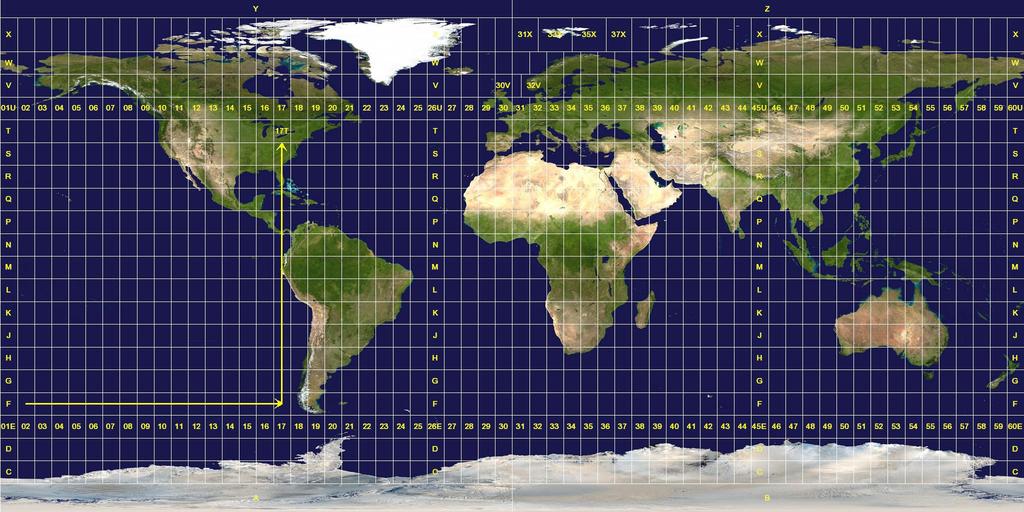
5 UTM System -Locations are identified by three numbers: Zone, Easting & Northing Each UTM zone spans 6 of longitude, from 84 North and 80 South. Zones taper from 666,000 meters in "width" at the Equator (where 1 of longitude is about 111 kilometers in length) to only about 70,000 meters at 84 North and about 116,000 meters at 80 South A UTM position is the zone number and the easting and northing planar coordinate pair in that zone. The point of origin of each UTM zone is the intersection of the equator and the zone s central meridian. To avoid negative numbers, the central meridian is designed to coincide with 500,000 meters East.
6
7 Maps Continuted (UTM System) -Locations can be identified by three numbers: Zone, Easting & Northing -The UTM system divdes the Earth between 80 S & 84 N latitude into 60 zones, each with 6 of longitude in width -Each latitude band is 8 degrees high, and is lettered starting from "C" at 80 S, increasing up the alphabet until "X The last latitude band, "X", is extended an extra 4 degrees, so it ends at 84 N latitude, thus covering the northernmost land on Earth.

8 Locating a UTM position A position is given by the UTM zone number and the easting & northing coordinate pair in that zone UTM grid coordinates are expressed as a distance in meters to the east & north UTM has grid lines spaced every 1km Eastings range from approx meters close to the poles, to m near the equator. Northings range from 0 at the equator to approximately 9,300,000 meters at 84 N
9 UNIS is at 33x The two first small digits refer to the 100 km route The two next large digits are called principal digits and refer to the 1 km route The last three digits represent the distance in meters east/north into the route. 4 digits accurate to 1000 meters 6 digits accurate to 100 meters 8 digits accurate to 10 meters, approximately the size of a house. 10 digits accurate to 1 meter.

10 3.50cm Map Scale- 1:100,000, UTM grid lines every 5cm UTM Coordinates of Fredheim: 33X E N cm

11 Map Scale=1:50,000, UTM grid lines every 2cm UTM Coordinates of Vespynten Lighthouse: 33X E N cm 85
12 Maps What is a map? What do we find on a map? Key Map Terms Scale Grid Orientation Legend Coordinate System Geodetic Datum Projection
13 Map/Coordinates Exercise USING the TURKART: What are the UTM coordinates/elevation of Innerhytta? Find the location from the UTM coordinates: 33x E N USING the C9 Map: What are the UTM coordinates/elevation of Janssonhaugen? Find the location from the UTM coordinates: 33x E N Convert UNIS Lat Long coordinates from Deg, Min, Sec to Decimal Degrees and Degrees Decimal Minutes. UNIS is ʺN ʺ E Remember!!! Degrees Minutes Seconds = ʺ Decimal Degrees = Degrees Decimal Minutes = minutes in 1 degree and 60 seconds in 1 minute 1 minute=1nautical mile=1.852km Decimal degrees= degrees + (minutes/60 + seconds/3600) Decimal degrees to decimal minutes= degree + decimal degree x 60
14 What is important to know about Svalbard Maps? You should be familiar with both the UTM and Longitude, Latitude Reference System! UTM is more common for land, while Longitude and Latitude are common for the sea If you have an emergency, report coordinates in Decimal Degree Minutes! We are in UTM Zone 33 X The Geodetic Datum we use is WGS84 Our magnetic declination is 7 20 East (changes every year) Glaciers! Moraines! Rivers! Sea Ice!


 Svalbard 1:250.")
15 Svalbard Maps In Svalbard the Norwegian Polar Institute provides a map service Maps are available in different scales which are published in several series Svalbard 1: (S500) Svalbard 1: (S250) Svalbard 1: (S100)
16 Svalbard Maps continued Overview of Svalbard topographic maps: Every map will contain: Name Scale Code Inset Maps Contour Lines/Data Map Data Legend
17 Svalbard Maps Continued TOPO Svalbard digital maps for Svalbard toposvalbard.npolar.no geodata.npolar.no (for downloading arcgis) Topographic Maps 3D Maps Aerial photos Satellite Imagery Let s look at Svalbard
18 Trip Planning Exercise Find on student server
19 Trip Planning Resources:
 CH MA10 Martime channel (helicopter) REP")
20 VHF Field Communication (Group to Group) Emergency Communication (Group to Vessel, Group to Group) BATTERIES! LOCK! Channels: CH P1 UNIS CH P2 UNIS CH MA 6 Martime channel SHIP to SHIP CH MA16 Martime channel (emergency) CH MA10 Martime channel (helicopter) REP CH1 Repeater Rep CH3 Repeater
21 Letter Code Letter Code A Alpha N November B Bravo O Oscar C Charlie P Papa D Delta Q Quebec E Echo R Romeo F Foxtrot S Sierra G Golf T Tango H Hotel U Uniform I India V Victor J Juliett W Whiskey K Kilo X X-Ray L Lima Y Yankee M Mike Z Zulu
22 Radio Procedures Sara Sara this is Group A, Group A, Over Group A, this is Sara, Over Sara, this is Group A, we are now at position 1, moving towards position 2, Over Group A this is Sara, roger that Sara, this is group A, out

23 Satellite Phones Field Communication (Group to UNIS) Emergency Communication (Group to UNIS, Group to Sysselmannen) Turning on procedures UNIS daytime UNIS On Duty 24/ Governor emergency 24/ Hospital It is NOT possible to call Norwegian emergency numbers 110, 112 and 113
24 Satellite Phone Procedures in an emergency: Present yourself Position (Degrees, Decimal Minutes) What kind of accident/injury Who is injured, state of injury Situation for rest of the group What kind of assistance do you need Agree on next time of contact

25 Emergency Beacon Emergency use ONLY 24 hrs signal in all conditions (not under water) Transmit on 406 MHz for world wide satellite coverage Local homing on 121,5 MHz for sysellmannen GPS unit gives accurate position information

26 Automatic GPS Tracking SMS Capabilities Emergency Function Iridium Satellite inreach

27


28 GPS Instrument which utilizes the Global Positioning System by connecting to satellites -Track your position and movement -Trackback -Make Waypoints tracks and routes -Navigate towards waypoints or tracks -Moving map -MAP datum, WGS 84 or ED 50 -Position ref, UTM or LAT/LONG -Transfer GPS data into PC map system (OZI Explorer)
29 Communications Exercise Find on the student server
Navigation and Communication UNIS Winter Safety Course January Sara Cohen Staff Engineer, Arctic Geology
 Navigation and Communication UNIS Winter Safety Course 08-12 January 2018 Sara Cohen Staff Engineer, Arctic Geology Course Objectives Navigation Maps, GPS, TopoSvalbard, Weather Communication VHF Radio,
Navigation and Communication UNIS Winter Safety Course. Sara Cohen Staff Engineer, Arctic Geology
 Navigation and Communication UNIS Winter Safety Course Sara Cohen Staff Engineer, Arctic Geology Course Objectives Use a Compass, Map & GPS for Navigation Use a VHF Radio, Satellite Phone & Emergency Beacon
Which page are each of these images from?
 Which page are each of these images from? A B C D Operated by Victoria Airport Authority We need your help to find 11 differences between these two fire rescue vehicles! start Help the cyclists find their
Geog Lecture 29 Mapping and GIS Continued
 Geog 1000 - Lecture 29 Mapping and GIS Continued http://scholar.ulethbridge.ca/chasmer/classes/ Today s Lecture (Pgs 13-25, 28-29) 1. Hand back Assignment 3 2. Review of Dr. Peddle s lecture last week
King County Explorer Search and Rescue. Course B Map & Compass
 King County Explorer Search and Rescue Course B Map & Compass Disclaimer The intent of this presentation is to provide a basic overview of maps, compasses, and location finding. It is not meant to be a
Welcome to Aerospace Engineering DESIGN-CENTERED INTRODUCTION TO AEROSPACE ENGINEERING
 Welcome to Aerospace Engineering DESIGN-CENTERED INTRODUCTION TO AEROSPACE ENGINEERING Topics 1. Course Organization 2. Today's Dreams in Various Speed Ranges 3. Designing a Flight Vehicle: Route Map of
12/26/2012. Geographic Information Systems * * * * GIS (... yrezaei
 ( - Geographic Information Systems ( ( 1 2 3 Information System Data base DB IS IS DB (Knowledge ( ( (System (Information System - (Georefrence Analysis Data + Knowledge ======== Information 4 5 ( < 10%
Butte County Fire Department
 Butte County Fire Department Basic Land Navigation Verification Sheet I verify that Print Supervisor s name has completed the Print Employee s name Basic Land Navigation self study guide on. Date Attached
Test Bank Chapter 2: Representations of Earth
 Multiple Choice Test Bank Chapter 2: Representations of Earth 1. A rhumb line on a Mercator projection is a line of. a. true size b. true shape c. true compass bearing d. true location 2. Maximum longitude
GCSAR Navigation -- Maps
 GCSAR Navigation -- Maps From the GCSAR Certification Standards Identify and explain all the border information on a topographic map. Identify and explain the following aspects of maps: index and intermediate
Chapter 3 Models of the Earth. 3.1 Finding Locations on the Earth. 3.1 Objectives
 Chapter 3 Models of the Earth 3.1 Finding Locations on the Earth 3.1 Objectives Explain latitude and longitude. How can latitude and longitude be used to find locations on Earth? How can a magnetic compass
Navigating with Map & Compass. Nevada County Sheriff s Search & Rescue
 Navigating with Map & Compass Nevada County Sheriff s Search & Rescue Objectives Very Practical Teach you how to go from point A to point B Go from the wilderness (real world) to a map and visa versa Agenda
Trail Life USA High Adventure Training Land Navigation Module. Dennis Conte
 Trail Life USA High Adventure Training Land Navigation Module Dennis Conte Navigating With GPS and a MAP Let s Talk about your GPS Hand Held Tool. Is a GPS Hand Held the magic bullet? Can it solve all
Chapter 3 Geographic Location Systems
 Chapter 3 Geographic Location Systems In this chapter you will learn about: Latitude and longitude Universal Transverse Mercator (UTM) U.S. Public Land Survey Other geographic location systems Geographic
Georeferencing. Place names Postal addresses Postal codes Coordinate systems (lat/long, UTM, etc.)
") Georeferencing Georeferencing Used to describe the act of assigning locations to data or information Certain requirements include that they are: unique, have shared meaning, and are persistent through
Georeferencing Georeferencing Used to describe the act of assigning locations to data or information Certain requirements include that they are: unique, have shared meaning, and are persistent through
Intro to GIS Fall 2010 Georeferencing & Map Projections
 Intro to GIS Fall 2010 Georeferencing & Map Projections SHAPE OF THE EARTH Earth's Shape Geoid: shape of earth minus topographic features (irregular due to local variations in gravity) Ellipsoid: elongated
WHERE ARE YOU? Maps & Geospatial Concepts Fall 2012
 WHERE ARE YOU? Maps & Geospatial Concepts Fall 2012 Where are you? Relative location I m at school Absolute Location 45 26 18.07 122 43 50.78 Datums Datums A reference surface of the Earth Used as the
Mapping coordinate systems
 Mapping coordinate systems 1. The Earth's Graticule Latitude and Longitude The graticule is the imaginary grid of lines running east-west (lines of latitude = parallels) and north-south lines of longitude
GIS in Water Resources. Fall Homework #1
 GIS in Water Resources Fall 2015 Homework #1 Goal The goal of this homework is to reinforce the lecture material on Geodesy, Map Projections and Coordinate Systems by having you identify attributes and
LONGITUDE AND LATITUDE. Semi great circles joining the true or geographic poles of the earth (true meridians).
.") MERIDIANS OF LONGITUDE LONGITUDE AND LATITUDE Semi great circles joining the true or geographic poles of the earth (true meridians). They are measured from 0 to 180 degrees East and West of the PRIME MERIDIAN,
MERIDIANS OF LONGITUDE LONGITUDE AND LATITUDE Semi great circles joining the true or geographic poles of the earth (true meridians). They are measured from 0 to 180 degrees East and West of the PRIME MERIDIAN,
Butte County Fire Department
 Butte County Fire Department Basic Land Navigation Verification Sheet I verify that Print Supervisor's name Print Employee's name has completed the Basic Land Navigation self study guide on Date Attached
What Do You See? FOR 274: Forest Measurements and Inventory. Area Determination: Frequency and Cover
 What Do You See? Message of the Day: Many options exist to determine the size, area, or extent of a feature on a landscape FOR 274: Forest Measurements and Inventory Lecture 7: Measures of Land Area Frequency
Land Navigation Table of Contents
 Land Navigation Table of Contents Preparatory Notes to Instructor... 1 Session Notes... 5 Learning Activity: Grid Reference Four Figure... 7 Learning Activity: Grid Reference Six Figure... 8 Learning Activity:
GPS Measurement Protocol
 GPS Measurement Protocol Purpose To determine the latitude, longitude, and elevation of your school and of all your GLOBE sites Overview The GPS receiver will be used to determine the latitude, longitude
Name Class Date. For each pair of terms, explain how the meanings of the terms differ.
 Skills Worksheet Chapter Review USING KEY TERMS For each pair of terms, explain how the meanings of the terms differ. 1. true north and magnetic north 2. latitude and longitude 3. equator and prime meridian
Akuni Adventures GPS Navigation Course. Welcome
 Akuni Adventures GPS Navigation Course Welcome 1 GPS Navigation Course Instructor: Joe Bourgeois joe@akuni.com 2 Waiver Please take a moment to read and sign your waiver. Thank You 3 Maps: Agenda Margin
Topographic Maps and Landforms Geology Lab
 Topographic Maps and Landforms Geology Lab Ray Rector: Instructor Today s Lab Activities 1) Discussion of Last Week s Lab 2) Lecture on Topo Maps and Elevation Contours 3) Construct Topographic Maps and
Latitude and Longitude Pre Test
 Name Date Latitude and Longitude Pre Test Multiple Choice Directions: For questions, 1 10 circle the answer that letter that best answers the question. Each question is worth 1 point each. 1. To locate
Basic Map Skills for the Outdoors
 Geography 80-20 80% of what there is to know, for 20% of the sweat Basic Map Skills for the Outdoors Map Scale Map source: US Geological Survey Four ways to indicate map scale: Representative fraction
This week s topics. Week 6. FE 257. GIS and Forest Engineering Applications. Week 6
 FE 257. GIS and Forest Engineering Applications Week 6 Week 6 Last week Chapter 8 Combining and splitting landscape features and merging GIS databases Chapter 11 Overlay processes Questions? Next week
Shape e o f f the e Earth
 1 Coordinate Systems & Projections Coordinate Systems Two map layers are not going to register spatially unless they are based on the same coordinate system. 2 Contents Shape of the earth Datum Projections
GPS Mapping. Teacher Instructions. Overview: Objectives: Materials: Answers to Student Worksheets:
 Overview: Scientists use Global Positioning System (GPS) receivers to map lava flows. GPS data are compiled by computer Geographic Information System (GIS) software into a digital map. Digital maps can
AS 410 Land Navigation. Chpt 4-1
 AS 410 Land Navigation Chpt 4-1 Overview Types of Maps Map Legends / Scales Latitude and Longitude Orienteering Why? Why important to learn how to read a compass and map? No cell phone coverage Mountain
Georeferencing, Map Projections, Cartographic Concepts. -Coordinate Systems -Datum
 Georeferencing, Map Projections, Cartographic Concepts -Map Projections -Coordinate Systems -Datum Map projection is "the process of systematically transforming positions on the Earth's spherical surface
Topographic Map Series:
 DEFINITION OF A MAP A MAP IS A GEOGRAPHIC PREPRESENTATION OF A PORTION OF THE EARTH S SURFACE DRAWN TO SCALE, AS SEEN FROM ABOVE. IT S USES COLORS, SYMBOLS AND LABELS TO REPRESENT FEATURES FOUND ON THE
Using Map and Compass Together
 Using Map and Compass Together In situations where you foresee a potential evacuation on foot, where there are no roads, and no indication as to the direction of travel (i.e., road signs), it is recommended
Marine Navigation Pt. 1. Marine Navigation Pt. 2
 Marine Navigation Marine Navigation Pt. 1 Introduction to Navigation Coordinate Systems Nautical Charts Aids to Navigation Tides Marine Navigation Pt. 2 The Magnetic Compass Obtaining a Fix Dead Reckoning
Dr. ABOLGHASEM AKBARI Faculty of Civil Engineering & Earth Resources, University Malaysia Pahang (UMP)
") Workshop on : Dr. ABOLGHASEM AKBARI Faculty of Civil Engineering & Earth Resources, University Malaysia Pahang (UMP) 14-15 April 2016 Venue: Tehran, Iran GIS definitions GIS: A simplified view of the real
Workshop on : Dr. ABOLGHASEM AKBARI Faculty of Civil Engineering & Earth Resources, University Malaysia Pahang (UMP) 14-15 April 2016 Venue: Tehran, Iran GIS definitions GIS: A simplified view of the real
Chapter 1 Overview of Maps
 Chapter 1 Overview of Maps In this chapter you will learn about: Key points when working with maps General types of maps Incident specific maps Map legend and symbols Map sources A map is a navigational
Coordinate Systems. Location on earth is defined by coordinates
 Coordinate Systems We think of the earth as a sphere It is actually a spheroid (ellipsoid), slightly larger in radius at the equator than at the poles Shape of the Earth Location on earth is defined by
Charts and Chart Work with Poole Sailing
 with Poole Sailing Nautical charts are a mine of information but they need to be up to date. Corrections to charts are published by the Hydrographic Office monthly as Notices to Mariners both in print
Topographic Maps Self-Instruction Lab (2016 edition) Geology 100 David Harbor s Section. 12 inches x 1 mile
 Geology 100 David Harbor s Section. 12 inches x 1 mile") Topographic Maps Name Self-Instruction Lab (2016 edition) Geology 100 David Harbor s Section Topographic maps are an important aid for a geologist, but maps are also useful for hikers, bicyclists, and
Topographic Maps Name Self-Instruction Lab (2016 edition) Geology 100 David Harbor s Section Topographic maps are an important aid for a geologist, but maps are also useful for hikers, bicyclists, and
Introduction to Geographic Information Science. Updates/News. Last Lecture. Geography 4103 / Map Projections and Coordinate Systems
 Geography 4103 / 5103 Introduction to Geographic Information Science Map Projections and Coordinate Systems Updates/News Thursday s lecture Reading discussion 1 find the readings online open questions,
WHERE ARE YOU? Maps & Geospatial Concepts Fall 2015
 WHERE ARE YOU? Maps & Geospatial Concepts Fall 2015 Where are you? Relative location I m at school Absolute Location 45 26 18.07 122 43 50.78 Where is Boston? Introducing Geodesy, Ellipsoids & Geoids Geodesy
B. Topographic maps are also called. contour maps
 Topographic Maps Introduction A. Topographic maps are essential tools in geologic and engineering studies because they show the configuration of Earth's surface in remarkable detail and permit one to measure
Background Information
 Oceanography LAB #1: Marine Charts and Navigation Background Information Latitude and Longitude A coordinate is an address a means of designating location. Most coordinate systems involve a network of
Basic Land Navigation. Clark County Sheriff Core Comp Rev. # Land Navigation
 Basic Land Navigation Clark County Sheriff Core Comp Rev. # 2018 1 Land Navigation Requirement Through written evaluation the applicant will demonstrate knowledge of land navigation involved in Search
Lecture 4. Coordinate Systems & Projections
 Lecture 4 Coordinate Systems & Projections Outline Geodesy Geoids Ellipsoids Geographic Coordinate Systems Magnetic North vs. True North Datums Projections Applying Coordinate Systems and Projections Why
The Wildlife Society Meet and Greet. Come learn about what the UNBC Student Chapter of TWS is all about!
 Georeferencing I GEOG 300, Lecture 4 Dr. Anthony Jjumba 1 The Wildlife Society Meet and Greet Quiz Come learn about what the UNBC Student Chapter of TWS is all about! 5:30 7:30 PM, Wednesday September
EnvSci360 Computer and Analytical Cartography
 EnvSci360 Computer and Analytical Cartography Lecture 3 Geodesy Map Projections, Datums, and Coordinate Systems 1 Geodesy The science of measuring and representing the shape and size of the earth, and
GEOGRAPHIC COORDINATE SYSTEMS
 GEOGRAPHIC COORDINATE SYSTEMS Introduction to GIS Winter 2015 What is Georeferencing? Used to establish a location on the Earth s surface 1 st order polynomial transformation Georeferencing toolbar What
Referencing map features: Coordinate systems and map projections
 Referencing map features: Coordinate systems and map projections Coordinate systems and map projections if we want to integrate geographic data from many different sources, we need to use a consistent
Spatial locations. Spatial locations. Spatial locations. Spatial locations
 Where am I? sounds simple, but definitely not huge amount of picky detail Cartographers make a career from the details focus on the minimum you need to know c Philip M. Dixon (Iowa State Univ.) Spatial
REFERENCING COORDINATE SYSTEMS MAP PROJECTIONS GEOREFERENCING
 GIS in Ecology SPATIAL REFERENCING COORDINATE SYSTEMS MAP PROJECTIONS GEOREFERENCING : :1 Where on earth? Early mapmakers recognized the need for a system that could locate features on the earth's surface.
Map projections. Rüdiger Gens
 Rüdiger Gens Coordinate systems Geographic coordinates f a: semi-major axis b: semi-minor axis Geographic latitude b Geodetic latitude a f: flattening = (a-b)/a Expresses as a fraction 1/f = about 300
EOS 102: Dynamic Oceans Exercise 1: Navigating Planet Earth
 EOS 102: Dynamic Oceans Exercise 1: Navigating Planet Earth YOU MUST READ THROUGH THIS CAREFULLY! This exercise is designed to familiarize yourself with Google Earth and some of its basic functions while
Earth Science Regents Reading Topographic Maps
 Earth Science Regents Reading Topographic Maps Name Period Quick Tutorial on Degrees, Minutes, and Seconds of Latitude and Longitude A degree of latitude on the surface of the earth is about 70 miles long.
Navigation. Longitude and Latitude Foundations of Navigation. MTPs:
 Navigation 3.01 Foundations of Navigation References: FTGU pages 177-178, 184-190 Transport Canada Study and Reference Guide Glider Pilot Canada Flight Training Manual Pilot Navigation http://en.wikipedia.org/wiki/transverse_mercator_projection#spherical_transverse_mercator
GIS in Water Resources Fall 2018 Homework #1
 GIS in Water Resources Fall 2018 Homework #1 Goal The goal of this homework is to reinforce the lecture material on Geodesy, Map Projections and Coordinate Systems by having you identify attributes and
1. Label a few examples of lines of latitude and lines of longitude on the globe above left.
 Oceanography 2 Location, Direction, and Distance on Nautical Charts Please read Appendix III in the textbook for reference. Learning Objectives for the first nautical chart Lab 1. Use the latitude-longitude
SECTION 4 PARCEL IDENTIFIERS 4.1 LONGITUDE AND LATITUDE
 SECTION 4 PARCEL IDENTIFIERS 4.1 LONGITUDE AND LATITUDE Most maps must be drawn in such a way that points and areas can be located accurately on the earth's surface and described objectively. A uniform
Positional Accuracy of the Google Earth Imagery In The Gaza Strip
 Positional Accuracy of the Google Earth Imagery In The Gaza Strip Maher A. El-Hallaq Associate Professor of Surveying Civil Engineering Department The Islamic University of Gaza, Palestine mhallaq@iugaza.edu.ps
Level 1 Geography, 2011
 91010 910100 1SUPERVISOR S Level 1 Geography, 2011 91010 Apply concepts and basic geographic skills to demonstrate understanding of a given environment 9.30 am ednesday Wednesday 2 November 2011 Credits:
2. GETTING STARTED WITH GIS
 2. GETTING STARTED WITH GIS What are geographic information systems and what are they used for? ArcGIS: ArcMap, ArcCatalog and ArcToolbox Vector data vs. raster data vs. attribute tables Polygons, polylines,
Georeferencing. Where on earth are we? Critical for importing and combining layers for mapping
 Georeferencing Where on earth are we? Critical for importing and combining layers for mapping 1. The Geoid Earth is not a perfect sphere, it is ellipsoidal.. earth is the 'Geoid'. The difference between
Mapping Our World Chapter 2
 Mapping Our World Chapter 2 Section 2.1: Latitude and Longitude Maps are flat models of threedimensional objects. For thousands of years people have used maps to define borders and to find places. With
Mapping Earth. How are Earth s surface features measured and modeled?
 Name Mapping Earth How are Earth s surface features measured and modeled? Before You Read Before you read the chapter, think about what you know about maps Record your thoughts in the first column Pair
NR402 GIS Applications in Natural Resources Lesson 4 Map Projections
 NR402 GIS Applications in Natural Resources Lesson 4 Map Projections From http://www.or.blm.gov/gis/ 1 Geographic coordinates Coordinates are expressed as Latitude and Longitude in Degrees, Minutes, Seconds
The World of Geography Pre-Test/Study Guide Chapter 1 Test
 Read each statement or question. On the lines below write the letter of the best answer. 1. Geographers look at the Earth 5. What are the two specific A. by studying cities first. measurements of Earth
Cartography the art of making maps
 Cartography the art of making maps A map is a drawing or a picture of the earths surface, showing how things are related to each other by distance, direction and size. Maps are used for: Navigation Distance
When the Earth Was Flat. Measurements were made using a plumb bob, a spirit level, and a stick. Also, the Stars.
 ABSTRACT Defining the shape of the Earth geoid. Mathematical models spheroid or ellipsoid Mathematical projection of geodetic systems GIS/GPS technology The need for a unified projection systems World
Geographers Tools: Location Systems Prof. Anthony Grande Hunter College Geography
 5 Geographers Tools: Location Systems Prof. Anthony Grande Hunter College Geography Lecture design, content and presentation AFG 0119 Individual images and illustrations may be subject to prior copyright.
What you learned. Lecture 27: Class Summary. Maps and geodesy. How you learned it
 What you learned Geography 12: Maps and Spatial Reasoning Lecture 27: Class Summary Professor Keith Clarke Map geometry, construction and content Practical map use, reading and navigation Map representation
56H. This system allows definition of points on the Earth s surface to within 100 meters. Page 20. Navigation Systems Basics of Maps
 Grid References Many maps are provided with the standard grid overlaying them. This provides a simple and accurate method for finding features on the map. It is a network of intersecting parallel lines
OCN 201 LAB FALL 2003 POLYNESIAN AND WESTERN NAVIGATION
 Name: OCN 201 LAB FALL 2003 POLYNESIAN AND WESTERN NAVIGATION INTRODUCTION People have been sailing the seas for thousands of years, during most of which time they relied on the sun and the stars to navigate
Use your text to define the following term. Use the terms to label the figure below. Define the following term.
 Mapping Our World Section. and Longitude Skim Section of your text. Write three questions that come to mind from reading the headings and the illustration captions.. Responses may include questions about
GEOMATICS ENGINEERING / SURVEYING
 1 GEOMATICS ENGINEERING / SURVEYING CHAPTER 1 Dr. Muhammad Ashraf Javid Assistant Professor Department of Civil and Environmental Engineering Email: muhammad.javid@unizwa.edu.om 2 Geomatics Engineering
Map Skills Unit. Note taking unit
 Map Skills Unit Note taking unit Introduction To learn about the Earth, we are going to learn about two geographic tools you can use.globes and maps. Globe A globe is a round model of the planet Earth
Classroom Outing
 Classroom Outing Government Of Canada Government Of BC, Printed by Gotrekkers: http://www.gotrekkers.com/bc-topo-20k-britishcolumbia-topographic-map/ Gemtrek Mark Klassen et al John Baldwin Chrismar
Practice Packet Topic 2: Measuring Earth
 Practice Packet Topic 2: Measuring Earth Vocabulary: Lesson 1: Lesson 2: Name: Lesson 3: Mini Lesson: Latitude Longitude Pre-Test 1. To locate exact places on the earth, one must look at a. The intersecting
Welcome to Lesson 4. It is important for a GIS analyst to have a thorough understanding of map projections and coordinate systems.
 Welcome to Lesson 4. It is important for a GIS analyst to have a thorough understanding of map projections and coordinate systems. A GIS without coordinates would simply be a database like Microsoft Excel
Map Skills Test. 1. What do we call a person who makes maps? a. mapographer b. cartographer c. geologist d. archaeologist
 Map Skills Test 1. What do we call a person who makes maps? a. mapographer b. cartographer c. geologist d. archaeologist 2. What is the name of the 0 latitude line? a. Equator b. Arctic Circle c. First
Earth Science: Chapter 2 Assessment
 Earth Science: Chapter 2 Assessment Do not write on this text booklet. Write the letter of the correct answer on your answer sheet. SECTION 1: Multiple Choice (50 points) Choose the letter of the BEST
1/28/16. EGM101 Skills Toolbox. Oblate spheroid. The shape of the earth Co-ordinate systems Map projections. Geoid
 EGM101 Skills Toolbox Oblate spheroid The shape of the earth Co-ordinate systems Map projections The geoid is the shape that the surface of the oceans would take under the influence of Earth's gravitation
What is a map? A Map is a two or three-dimensional model or representation of the Earth s surface. 2-Dimensional map
 What is a map? A Map is a two or three-dimensional model or representation of the Earth s surface. 2-Dimensional map What is a Map Projection? Planar Projection Projection A Projection is a mathematical
Road Scholar. Coaches Clinic
 Coaches Clinic Test Format Review of Individual Test Elements Items to Bring Tips Links General Test Format: Storyline Test Navigation Elements Identification of Landmarks, features, etc. Aerial/Satellite
Map Projections. Displaying the earth on 2 dimensional maps
 Map Projections Displaying the earth on 2 dimensional maps Map projections Define the spatial relationship between locations on earth and their relative locations on a flat map Are mathematical expressions
Projections and Coordinate Systems
 Projections and Coordinate Systems Overview Projections Examples of different projections Coordinate systems Datums Projections Overview Projections and Coordinate Systems GIS must accurately represent
GIST 3300 / Geographic Information Systems. Last Time. Today
 GIST 3300 / 5300 Last Time Ellipsoids and Datums Today Map Projections Map Projections Today we will build on the concepts of Geographic Coordinate Systems, Ellipsoids and Datums and add the concepts of
CHAPTER EXIT CHAPTER. Models of Earth. 3.1 Modeling the Planet. 3.2 Mapmaking and Technology. 3.3 Topographic Maps CHAPTER OUTLINE
 EXIT CHAPTER.1 Modeling the Planet.2 Mapmaking and Technology. Topographic Maps CHAPTER OUTLINE CHAPTER.1 Modeling the Planet A flat of Earth is a convenient tool, but it can distort the shape, distance,
Chapter 1 Test on Geography Skills
 Name Score Chapter 1 Test on Geography Skills Part 1 Matching (14 pts.) Match each term in Column B with its correct definition in Column A by clearly writing the number in the blank space provided. Two
The Elements of GIS. Organizing Data and Information. The GIS Database. MAP and ATRIBUTE INFORMATION
 GIS s Roots in Cartography Getting Started With GIS Chapter 2 Dursun Z. Seker MAP and ATRIBUTE INFORMATION Data (numbers and text) store as files refer to them collectively as a database gather inform.
Draft exercise for share fair at Bozeman workshop only. This exercise is not ready for distribution. Please send helpful suggestions to
 Draft exercise for share fair at Bozeman workshop only. This exercise is not ready for distribution. Please send helpful suggestions to foleyd@plu.edu Figure list 1. Trailer photograph 2. Location map
Mapping Earth s Surface Chapter 2 Section 3
 Mapping Earth s Surface Chapter 2 Section 3 Day 1 Objective I will understand maps can be used to find locations on Earth and to represent information about features on Earth s Surface I will understand
5 Themes of Geography Review Video Notes What is Geography?
 Name PG # 5 Themes of Geography Review Video Notes What is Geography? The study of, their, and their Main Idea or Topic Continents Notes about Main Idea or Topic There are 7 Continents or in the world:
GISC3325 Class 2 - Latitude and Longitude on Sphere. 28 January 2013
 GISC3325 Class 2 - Latitude and Longitude on Sphere 28 January 2013 Geodesy Defined The science describing the size, shape and gravity field of the Earth in its threedimensional time-varying states. Branch
Appendix B Calculating Pipe Length and Mean Slope from GPS Data
 Appendix B Calculating Pipe Length and Mean Slope from GPS Data B.1 THE BASICS: NORTHING AND EASTING Dimensions of the potential site for a water network can be measured with landbased surveying equipment,
Geography involves the study of places: their locations, their characteristics, and how humans use and move around them.
 Physical Geography Looking at the Earth Geography involves the study of places: their locations, their characteristics, and how humans use and move around them. NEXT Physical Geography Looking at the Earth
Scientists observe the environment around them using their five senses.
 Earth Science Notes Topics 1: Observation and Measurement Topic 2: The Changing Environment Review book pages 1-38 Scientists observe the environment around them using their five senses. When scientists
Introduction to GPS and Orienteering
 Introduction to GPS and Orienteering There are a wide variety of GPS units available. Most GPS units are fairly similar though not exactly the same. This tutorial is specific to the Garmin emap GPS. If