Akuni Adventures GPS Navigation Course. Welcome
|
|
|
- Dana Cannon
- 5 years ago
- Views:
Transcription
1 Akuni Adventures GPS Navigation Course Welcome 1
2 GPS Navigation Course Instructor: Joe Bourgeois 2
3 Waiver Please take a moment to read and sign your waiver. Thank You 3
4 Maps: Agenda Margin Information Locating Points on a Map Scale and Distance North on a Map Compass: Parts of Compass Following a bearing 4
5 Agenda GPS History How it works WAAS Menus and Setup 5
6 Learning Tools: Student Workbook Large Topographical Map of Bolton and Mattawa Map of Area Clip Board Metre stick as a tool to determine coordinates Seconds Measuring tool Please do not make any marks on the maps!! 6
7 Becoming a Competent Navigator requires an understanding of the: The Map, the Compass and the GPS 7
8 Maps 8
9 Maps The map will always be necessary. The digital computer map, the cartography on the GPS screen, the traditional paper map. these are the first three questions you must ask yourself: 9
10 3 Important Map Questions Where are you on the map? Current Location Where are you going? Destination How am I going to specifically identify these locations? Means of Measurement 10
11 Means of Measurement Inventor of the Latitude and Longitude system. Ptolemy (approx AD) was the first to place a grid system on a map and use the same grid system for the entire planet. Inventor of the Universal Transverse Mercator (UTM) projection. Gerardus Mercator ( ), a Flemish cartographer, introduced the term atlas for a collection of maps.
12 Latitude & Longitude vs. Universal Transverse Mercator Latitude and Longitude system Example: N049 o W081 o Latitude is horizontal lines, Longitude is vertical lines Uses degrees, minutes, and decimal minutes (or seconds) Universal Transverse Mercator (UTM) Example: 17T E N Eastings is vertical lines, Northings is horizontal lines Uses the metric system. Based on metres.
13 And the Winner is We choose to use the UTM system for mapping and navigating because its coordinates are based on the metric system. UTM ZONE UTM Here s a sample coordinate: Easting The 0 is shown on Garmin units as a significant place holder E T N Northing
14 Maps Map Margin Information 14
15 Topographic Map Tour Grid North, True North, and Magnetic North (manual p. 23) Grid Zone Designation: 17T (manual p.6) North American Datum 1983 (NAD83) American Datum 1927 (NAD27) Scale 1: Bolton 30 M/13 E Eastings (584000) N Northings ( ) Latitude ( ) Longitude ( ) E Eastings (587000) N Northings ( ) Latitude ( ) Longitude ( )
16 Map Scale for Wilderness Travel 1/ Scale Map 1/ scale map gives a general overview of a large area and is a perfect guide for pre-trip planning. It covers an area of approximately square kilometres or 160 km x 110 km, and depicts numerous aspects of the terrain. Refer to the map detail and natural landmarks to guide yourself through unfamiliar areas. A 1/ Scale Map 1/ scale map is highly detailed and covers an area of approximately square kilometres or 40 km x 28 km. It shows vegetation, cultural information, approved names (toponymy), land elevation and water bodies, in great detail. Note: A 1/ scale map covers the same area as sixteen 1/ scale maps. 16
17 Exercise 1 Map Margin Information 17
18 Maps Locating Points on a Map 18
19 Maps Maps Geographic Coordinates (Latitude and Longitude) 19
20 Geographic Coordinates (Latitude and Longitude) are internationally recognized for use in land, sea and air navigation. UTM may or may not be a recognized coordinate in some countries. 20

21 N W Latitude and Longitude Geographic Coordinates 21
22 Geographic Coordinates Geographic Coordinates are the world-wide system of latitude and longitude used to define the location of any point on the earth's surface. The oldest and most Internationally recognized reference system. 22
23 How Geographic Coordinates work 23

24 Geographic Coordinates are written as: N Latitude W Longitude Degrees Minutes Seconds Cardinal Direction 24

25 Longitude Latitude 25
26 44 N Note: these are angular measurements not time measurements There are 60 Minutes in one degree 43 N 80 W 79 W 26
27 There are 60 second in one minute 43 N 80 W 79 W 27

28 Let s try with a Canadian Topographical Map: First find the latitude degrees North Latitude = 45 N 28
29 Next find the minutes North Latitude = N 29

30 Last find the seconds North: Latitude = N 30

31 Now find the degrees longitude West Longitude = 80 W 31

32 Next find the minutes west Longitude = W 32

33 Last find the seconds West Longitude = W 33

34 The geographic coordinate for point A is: Latitude = N Longitude = W 34
35 Alternatives to represent Latitude and Longitude: Latitude = N Longitude = W Same as: Latitude = N Longitude = W Same as: Latitude = N Longitude = W 35
36 Example 36
37 Together we will try Exercise #2 (in Workbook- Instructor Lead) 37
38 With your partner try Exercise #3 and #4 (in Workbook) 38
39 Geographic Distances At any point on the earth, the ground distance covered by one degree of latitude is about 111 kilometers (69 miles);; One Minute equals one nautical mile(nm). one second is equal to about 30 meters (100 feet). The ground distance covered by one degree of longitude at the equator is also about 111 kilometers, but decreases as one moves north or south, until it becomes zero at the poles. Ground distance can be measured from the latitude lines on the side of the map. 39
40 So what s the difference between a Nautical Mile and a Statute Mile? A Nautical Mile is the ground distance of one Minute. A Statute Mile is defined as 5280ft based on the English foot or American foot (now obsolete). The International Mile is defined as 5280ft based on the International foot. The difference between a Statue Mile and International mile is 3mm. 40
41 Summary Geographic Coordinates are Made up of Degrees, Minutes and Seconds for both latitude and longitude Geographic Coordinates are important for trip planning and emergency response. Use it or lose it! Make an effort to practice geographic coordinates until this becomes second nature. 41
42 Break 42
43 Maps Maps Universal Transverse Mercator's (UTM) 43
44 UTM Grid UTM Grid is a world wide system based on metres from a reference point. The horizontal lines (Northings) are numbered in metres from the equator. With the southern most point in Canada being 4,620,000 metres from the equator, all Northing values will be above this number. 44
45 UTM Grid Cont d Vertical lines (eastings) are measured from a separate point for each zone, an imaginary line lying metres west of the zone's central meridian 45

46 Maps: Locating points on a map Worldwide UTM Grid Zones 60 ZONES 46
47 What a Zone Looks Like ZONE 17T 5,100,000m (From Equator) 000m (Theoretical) 500,000m 1,000,000m (Theoretical) 47
48 What a Grid Looks Like m N. 26 Object Location: Zone 17T Easting: E Northing: N m N m E m E. 17T 48
49 What we really use m N. 26 Normally we only consider a reference down to 10 or 100 meters m N m E m E. 17T The conventional way to reference this object is: (10m) Or (100m) Reference :Map 31 E/17 Where the first half of the reading is Easting, and the second half the Northing. You must indicate the map when using this reference. 49

50 Example 50
51 Use of a Roamer m N. 26 A roamer can be used for more accuracy. Usually you can get to 10 meter accuracy. Roamers are separate templates or found on higher end compasses m N m E m E. 17T 51
52 Lets Find Some Points What is the UTM for the yellow dot? What is the UTM for the green dot? What is the UTM and Lat. Long decimal minutes? What is the UTM and Lat. Long decimal minutes
53 Answers 17T E N Lat Long T E N Lat Long T E N Lat Long ? 17T E N Lat Long
54 With your partner try Exercise #5 (in Workbook) 54
55 Maps North on a Map 55
56 North on a Map There are three North references on a topographical map: True North Magnetic North Grid North 56
57 True North True North is the direction of the north pole from any given point. The grid lines on a map are not pointing accurately to the north pole due to grid error (round earth, square paper). You must make a correction to determine true north. 57
58 Grid North Grid north is the direction of the north-south lines on a map. Except through the origin, grid lines do not lie true north and south or east and west. 58
59 Grid North A correction must be calculated to find True north. If the Grid North on the map is indicated as 0 53 East of True North, and the magnetic declination is West of True North. The bearing adjustment would be: Bearing = [Add ( ) ] to your reading to get True North bearing on your compass. 59
60 Grid North In reality, unless you are in the high Arctic the Grid North deviation is negligible. If Grid North is less then 1 degree it is ignored. 60
61 Magnetic North Magnetic North is the point, in the far north of Canada, to which a compass needle points. Magnetic Declination is the angle between true north and magnetic north. Magnetic declination must be adjusted when taking a bearing from a map. 61
62 The Compass 62
63 Compass Parts of a Compass 63

64 64
65 Compass Compass Use 65
66 Compass Use How to hold a compass Tips on compass use 66
67 How to hold a compass Always hold the compass level If using an orienteering or siting compass hold it at eye level and use the mirror or site Watch out for and avoid anything that will affect the compass Pick a reference object to walk to Until you are comfortable traveling with a compass keep in mind the carpenters adage: measure once, cut twice;; measure twice, cut once this means take your time and do things carefully 67
68 Tips on compass use Take your time Be as accurate as you can Always be aware of your environment and anything in it that can affect the compass reading (power lines, pipelines, vehicles, rifles, magnets on flashlights, etc) People walking across a slope will tend to slide downhill without being aware pick good references and go to them 68
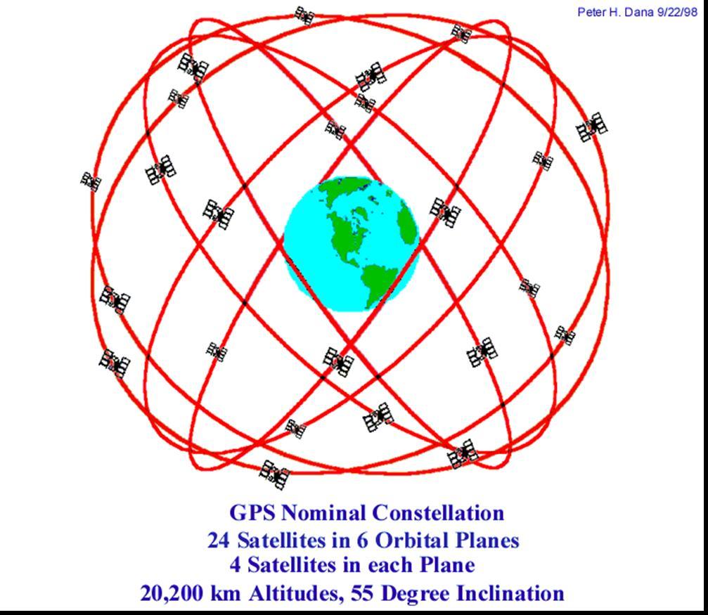
69 Tips on compass use cont d Most people have one leg shorter than the other, this will cause you to drift toward the direction of your shorter leg When going around obstacles alternate sides, left one the right one The old method of leapfrogging a partner to maintain an accurate line of travel is time consuming and no more accurate than just reading the compass and walking 69
70 Compass Plotting and Following a Bearing 70
71 Compass bearings Bearing: The horizontal angle at a given point, measured clockwise from magnetic north or true north to a second point. Back bearing: the reciprocal angle from a second point back to your location 71
72 Take Bearing in the Field (compass only) 1. Hold compass level in front of you, and point direction of travel line at a target. 2. Rotate compass housing to align pointed end of declination arrow with red end of magnetic needle ( Box the needle) 3. Read the bearing at index line. 72
73 Follow a Bearing in the Field 1. Set desired bearing at index line. 2. Hold compass level in front of you, and turn your entire body, including your feet, until red end of magnetic needle is aligned with pointed end of declination arrow. ( Box the needle) 3. Travel in the direction shown by the direction of travel line. If you do not see your destination in front of you because of obstacles such as trees, travel toward an object you see ahead of you. Once there, repeat step 2 and 3 until you arrive at your destination. 73
74 Exercise Following a bearing (Instructor led) 74
75 GPS Global Positioning System 75
76 GPS: A Brief History Developed (and owned) by the US DOD Originally intended to be a military tool. 2 levels of service: Standard Positioning Service (SPS) Precise Positioning Service (PPS) In development since the early 1970 s First satellite launched in 1978, full constellation by 1994
77 How does GPS Work? A four step process Satellite Triangulation Receiver measures distance using the travel time or radio signals Gets the exact location of the satellites in orbit Corrects any errors that occur A GPS Unit requires 3 satellites to lock onto before it can get a coordinate reading.
78
79 A GPS Receiver GPS does not send information - It will not tell other people where you are. Your GPS unit will show your location with a reception from 3 or more satellites, Reception can be affected by thick forest, buildings or the roof of your car. Two Dimensional Navigation (2DNAV) is sufficient for navigating. Three Dimensional Navigation (3DNAV) works the same as 2DNAV but includes which extra dimension? ELEVATION
80 WAAS Wide Area Augmentation System WAAS is a feature found on most higher end GPS s. It provides a higher level of accuracy down to about 3 meters compared to 10 meters on GPSs without WAAS. Initially setup for aviation use. 80
81 How WAAS works Two satellites available in the continental U.S., one over the Atlantic, and One over the Pacific. Both are in Geostationary orbits above the equator. A network of ground based stations that double check the GPS standard signal for errors. The corrections are relayed to the WAAS enabled satellites WAAS satellites are numbered 33 or higher 81
82 How WAAS works Initial reception may take minutes and 1-2 minutes thereafter Accuracy is 3-5 meters 95% of the time with WAAS m accuracy without WAAS. Must be in clear open view of the sky. No obstructions, because the satellites are sitting in the geostationary orbit. To improve performance of your GPS, disable this feature. It requires more resources and can slow your system down and use more battery power. GPS without WAAS are 50% accurate on the vertical readings. More info at 82
83 DGPS Differential Global Positioning System For marine use. Used to guide ships in tight ports where accuracy is important. Broadcast from land based antennas. GPS needs a special antenna. 3-5 meter accuracy 83
84 GLONASS Global Navigation Satellite System GLONASS is a Russian satellitebased navigation system that works alongside GPS to provide position information to compatible devices. With an additional 24 satellites to utilize, GLONASS compatible receivers can acquire satellites up to 20% faster than devices that rely on GPS alone. 84
85 Some GPS terms Position (POS, POSN) Your current location, given in reference to a chosen grid system. Waypoint/Landmark (WPT, LMK) A location described by a name and a grid reference. Bearing (BRG) The angle, in degrees, from magnetic North between your current position and a waypoint. Distance (DST) The straight-line distance between your current position and a waypoint. Track (TRK) A group of past positions, strung together in sequence, showing a relative path. Speed (SPD) Rate of travel
86 Map Datum The earth is an ellipsoid. A datum defines how a coordinate system is seated over the ellipsoid. Canadian Maps datums are either "North American Datum 1927" or "North American Datum 1983". NAD 83 is the most common. GPS use the world wide standard WGS84 86
87 Turn on the GPS Hold the power button for about a second. Don t forget to wear your wrist strap! Set your unit to SIMULATOR for use indoors! Listen and follow your instructor. Don t jump ahead or you ll get lost!
88 The Main Pages Every GPS displays its information on a set of main pages. These pages include: Satellite Page Map Page Compass Page Position Page Main Menu Page

89 Set Your GPS to Simulator (Use Indoors) Change mode from Normal to Simulator for use indoors.

90 SATELLITE PAGES Garmin Garmin Garmin Garmin etrex 12 etrex Vista 60 This is where we check if we have an adequate signal to use the GPS The outer circle is the horizon, the inner circle is a 45 o angle in the sky, and the dot in the centre is straight up. The numbers in the circle correspond to the numbers in the bar diagram 2DNAV is X and Y axis. 3DNAV has a third dimension: Y


91 MAP PAGES Garmin etrex Garmin 12 Garmin 72 Garmin 60 TRAK MAPS Some GPS units come with maps, others require a map to be uploaded to the unit. Use the zoom option to change the scale of your map Use the pan option to look at the off-screen parts of the map *quit or esc gets you back Set your map to North Up or Track Up


92 COMPASS PAGES Garmin etrex Garmin 12 Garmin 72 Garmin 60 Garmin 60c This is the screen we use to navigate to a given waypoint On newer units, you can manipulate the data fields to show what s important to you The arrow will show you the direction to travel *straight line The arrow is usually wrong if you are standing still you have to be moving!
93 POSITION PAGES Garmin etrex Garmin 12 Garmin etrex Vista Garmin 60 On newer units, your position is given right on the Satellite Page The accuracy of these coordinates will depend on satellite reception Position will likely be wrong if your map datum isn t set properly

94 MAIN MENU PAGES Garmin etrex Garmin 12 Garmin etrex Vista


95 Setup Menus The Setup Menu can usually be found on the Main Menu page. The setup menu is where you access All the various settings which you need To know about to properly operate your GPS. Newer units have more options. Garmin etrex Lets Set our units..(next slide) Garmin 60c
96 Setting your GPS Be sure to set the map datum to WGS 84 or the specific datum shown on the map you are using Set your Position Format (UTM or Lat/Long) Set the Units (metric or imperial) See the next slide for an example.


97 Navigation Setup Position Format Map Datum Units
98
99 Google Magnetic Declination Calculator NRCAN

100
101

102

103

104 THE END
GPS Measurement Protocol
 GPS Measurement Protocol Purpose To determine the latitude, longitude, and elevation of your school and of all your GLOBE sites Overview The GPS receiver will be used to determine the latitude, longitude
Navigating with Map & Compass. Nevada County Sheriff s Search & Rescue
 Navigating with Map & Compass Nevada County Sheriff s Search & Rescue Objectives Very Practical Teach you how to go from point A to point B Go from the wilderness (real world) to a map and visa versa Agenda
King County Explorer Search and Rescue. Course B Map & Compass
 King County Explorer Search and Rescue Course B Map & Compass Disclaimer The intent of this presentation is to provide a basic overview of maps, compasses, and location finding. It is not meant to be a
Land Navigation Table of Contents
 Land Navigation Table of Contents Preparatory Notes to Instructor... 1 Session Notes... 5 Learning Activity: Grid Reference Four Figure... 7 Learning Activity: Grid Reference Six Figure... 8 Learning Activity:
OCN 201 LAB FALL 2003 POLYNESIAN AND WESTERN NAVIGATION
 Name: OCN 201 LAB FALL 2003 POLYNESIAN AND WESTERN NAVIGATION INTRODUCTION People have been sailing the seas for thousands of years, during most of which time they relied on the sun and the stars to navigate
1/28/16. EGM101 Skills Toolbox. Oblate spheroid. The shape of the earth Co-ordinate systems Map projections. Geoid
 EGM101 Skills Toolbox Oblate spheroid The shape of the earth Co-ordinate systems Map projections The geoid is the shape that the surface of the oceans would take under the influence of Earth's gravitation
Basic Map Skills for the Outdoors
 Geography 80-20 80% of what there is to know, for 20% of the sweat Basic Map Skills for the Outdoors Map Scale Map source: US Geological Survey Four ways to indicate map scale: Representative fraction
Compass Basics. Quick Map Basics Review For Compass Use
 Compass Basics Quick Map Basics Review For Compass Use A topographic map tells you where things are and how to get to them, whether you're hiking, biking, hunting, fishing, or just interested in the world
Red Star Navigation. Bearings:
 Red Star Navigation Bearings: The main focus in Red Star Navigation is how to use a compass and in particular compass bearings. It is important for cadets to describe bearings as this will assist them
COORDINATE SYSTEMS: LOCATING YOURSELF ON A SPHERE
 NAME DATE PARTNER(S) COORDINATE SYSTEMS: LOCATING YOURSELF ON A SPHERE Activity 1: Getting Your Bearings 1. Close your eyes and point to the north. Did you point up? Why or why not? Up is the #1 answer.
Spatial locations. Spatial locations. Spatial locations. Spatial locations
 Where am I? sounds simple, but definitely not huge amount of picky detail Cartographers make a career from the details focus on the minimum you need to know c Philip M. Dixon (Iowa State Univ.) Spatial
Trail Life USA High Adventure Training Land Navigation Module. Dennis Conte
 Trail Life USA High Adventure Training Land Navigation Module Dennis Conte Navigating With GPS and a MAP Let s Talk about your GPS Hand Held Tool. Is a GPS Hand Held the magic bullet? Can it solve all
Butte County Fire Department
 Butte County Fire Department Basic Land Navigation Verification Sheet I verify that Print Supervisor s name has completed the Print Employee s name Basic Land Navigation self study guide on. Date Attached
Using Map and Compass Together
 Using Map and Compass Together In situations where you foresee a potential evacuation on foot, where there are no roads, and no indication as to the direction of travel (i.e., road signs), it is recommended
Map Reading & Compass Use
 Spring 2013 Kestrel Land Trust Page 2 / 10 Contents Map Basics... 3 Map Types... 3 Terrain Association... 4 Estimating Distance: Pacing... 4 Contour Lines... 5 Navigating with a Compass... 6 Compass Types...
Navigating for Scouts A Self-teaching Guide to Navigation with Map and Compass
 Don Burgess, November 2003 Materials topographic maps Navigating for Scouts A Self-teaching Guide to Navigation with Map and Compass metric ruler orienteering compass 30 M/5 Hamilton-Burlington 41 I/13
Chapter 3 Models of the Earth. 3.1 Finding Locations on the Earth. 3.1 Objectives
 Chapter 3 Models of the Earth 3.1 Finding Locations on the Earth 3.1 Objectives Explain latitude and longitude. How can latitude and longitude be used to find locations on Earth? How can a magnetic compass
Introduction to GPS and Orienteering
 Introduction to GPS and Orienteering There are a wide variety of GPS units available. Most GPS units are fairly similar though not exactly the same. This tutorial is specific to the Garmin emap GPS. If
Topographic Map Series:
 DEFINITION OF A MAP A MAP IS A GEOGRAPHIC PREPRESENTATION OF A PORTION OF THE EARTH S SURFACE DRAWN TO SCALE, AS SEEN FROM ABOVE. IT S USES COLORS, SYMBOLS AND LABELS TO REPRESENT FEATURES FOUND ON THE
USING THE MILITARY LENSATIC COMPASS
 USING THE MILITARY LENSATIC COMPASS WARNING This presentation is intended as a quick summary, and not a comprehensive resource. If you want to learn Land Navigation in detail, either buy a book; or get
Geog Lecture 29 Mapping and GIS Continued
 Geog 1000 - Lecture 29 Mapping and GIS Continued http://scholar.ulethbridge.ca/chasmer/classes/ Today s Lecture (Pgs 13-25, 28-29) 1. Hand back Assignment 3 2. Review of Dr. Peddle s lecture last week
EOS 102: Dynamic Oceans Exercise 1: Navigating Planet Earth
 EOS 102: Dynamic Oceans Exercise 1: Navigating Planet Earth YOU MUST READ THROUGH THIS CAREFULLY! This exercise is designed to familiarize yourself with Google Earth and some of its basic functions while
Map and Compass Skills
 Map and Compass Skills Grade levels: 5-12 In a Nutshell Given a map and compass, students will be able to find a location on the map, chart a course to that location with the compass, and find that location
The Tacoma Mountaineers Wilderness Navigation
 The Tacoma Mountaineers Wilderness Navigation Navigation Fundamentals Navigation in mountainous terrain and wilderness areas requires a set of skills, of which using a map and compass is only one part.
Surveying Prof. Bharat Lohani Department of Civil Engineering Indian Institute of Technology, Kanpur
 Surveying Prof. Bharat Lohani Department of Civil Engineering Indian Institute of Technology, Kanpur Module - 12 Lecture - 1 Global Positioning System (Refer Slide Time: 00:20) Welcome to this video lecture
How to Use a Compass
 How to Use a Compass The compass consists of a magnetized metal needle that floats on a pivot point. The needle orients to the magnetic field lines of the earth. The basic orienteering compass is composed
How to Use a Compass with a USGS Topographic Map
 How to Use a Compass with a USGS Topographic Map METHOD #1: (these directions assume your orienting arrow lines up with the North indicator on your compass dial, meaning the compass has not been adjusted
BUSH NAV BUSH NAV DAY Navigation for Bush Navigation Day. November. WhitehorseD AY. Section 1 Registration, Maps & Checkpoints
 BUSH DAY Navigation for Bush Navigation Day Robert Kirwan, Nunawading SES W NW N NE E If you have little or no bush navigation experience then you will have been teamed up with members that have that experience
PROJECTIONS AND COORDINATES EXPLORED THROUGH GOOGLE EARTH EXERCISE (SOLUTION SHEET)
") PROJECTIONS AND COORDINATES EXPLORED THROUGH GOOGLE EARTH EXERCISE (SOLUTION SHEET) Name: Date: Period: Note: Correct answers on some problems are indicated with a yellow highlight. PROJECTIONS 1. Here
PROJECTIONS AND COORDINATES EXPLORED THROUGH GOOGLE EARTH EXERCISE (SOLUTION SHEET) Name: Date: Period: Note: Correct answers on some problems are indicated with a yellow highlight. PROJECTIONS 1. Here
Activities: Map and Compass
 Activities: Map and Compass Determining General Directions Modified with permission from Outdoor Living Skills Series: Map and Compass, Missouri Department of Conservation Overview: Students use the sun
Lesson 3: Locating Plots on the Ground
 Review and Introduction Lesson 3: Locating Plots on the Ground So far, you have identified individual stands in the forest, learned about plot sampling, and marked locations on a map of where your inventory
What Do You See? FOR 274: Forest Measurements and Inventory. Area Determination: Frequency and Cover
 What Do You See? Message of the Day: Many options exist to determine the size, area, or extent of a feature on a landscape FOR 274: Forest Measurements and Inventory Lecture 7: Measures of Land Area Frequency
Navigation. Longitude and Latitude Foundations of Navigation. MTPs:
 Navigation 3.01 Foundations of Navigation References: FTGU pages 177-178, 184-190 Transport Canada Study and Reference Guide Glider Pilot Canada Flight Training Manual Pilot Navigation http://en.wikipedia.org/wiki/transverse_mercator_projection#spherical_transverse_mercator
Relative and Absolute Directions
 Relative and Absolute Directions Purpose Learning about latitude and longitude Developing math skills Overview Students begin by asking the simple question: Where Am I? Then they learn about the magnetic
USING THE MILITARY LENSATIC COMPASS
 USING THE MILITARY LENSATIC COMPASS WARNING This presentation is intended as a quick summary, and not a comprehensive resource. If you want to learn Land Navigation in detail, either buy a book; or get
Welcome to Lesson 4. It is important for a GIS analyst to have a thorough understanding of map projections and coordinate systems.
 Welcome to Lesson 4. It is important for a GIS analyst to have a thorough understanding of map projections and coordinate systems. A GIS without coordinates would simply be a database like Microsoft Excel
Shape e o f f the e Earth
 1 Coordinate Systems & Projections Coordinate Systems Two map layers are not going to register spatially unless they are based on the same coordinate system. 2 Contents Shape of the earth Datum Projections
Mapping coordinate systems
 Mapping coordinate systems 1. The Earth's Graticule Latitude and Longitude The graticule is the imaginary grid of lines running east-west (lines of latitude = parallels) and north-south lines of longitude
GPS Mapping. Teacher Instructions. Overview: Objectives: Materials: Answers to Student Worksheets:
 Overview: Scientists use Global Positioning System (GPS) receivers to map lava flows. GPS data are compiled by computer Geographic Information System (GIS) software into a digital map. Digital maps can
Lesson Plan 2 - Middle and High School Land Use and Land Cover Introduction. Understanding Land Use and Land Cover using Google Earth
 Understanding Land Use and Land Cover using Google Earth Image an image is a representation of reality. It can be a sketch, a painting, a photograph, or some other graphic representation such as satellite
Georeferencing, Map Projections, Cartographic Concepts. -Coordinate Systems -Datum
 Georeferencing, Map Projections, Cartographic Concepts -Map Projections -Coordinate Systems -Datum Map projection is "the process of systematically transforming positions on the Earth's spherical surface
HOW TO TRAVEL ON EARTH WITHOUT GETTING LOST
 HOW TO TRAVEL ON EARTH WITHOUT GETTING LOST Using a globe to learn how a position on Earth can be described. Rui Dilão, Instituto Superior Técnico Curriculum topic latitude, longitude, coordinate system
REVISION: MAPWORK 18 SEPTEMBER 2014
 REVISION: MAPWORK 18 SEPTEMBER 2014 Lesson Description In this lesson we revise: Various mapwork calculations Summary Relative Position Bearing is the angular (angle) distance between two points True Bearing
Navigation and Communication UNIS Winter Safety Course. Sara Cohen Staff Engineer, Arctic Geology
 Navigation and Communication UNIS Winter Safety Course Sara Cohen Staff Engineer, Arctic Geology Course Objectives Use a Compass, Map & GPS for Navigation Use a VHF Radio, Satellite Phone & Emergency Beacon
Butte County Fire Department
 Butte County Fire Department Basic Land Navigation Verification Sheet I verify that Print Supervisor's name Print Employee's name has completed the Basic Land Navigation self study guide on Date Attached
AP Human Geography Chapter 1: Thinking Geographically Key Issue 1: How do Geographers describe where things are?
 AP Human Geography Chapter 1: Thinking Geographically Key Issue 1: How do Geographers describe where things are? Studying Human Geography Physical Geography Physical geography deals with Earth s natural
Navigation and Communication AS January Sara Mollie Cohen Head Engineer, Department of Arctic Geology
 Navigation and Communication AS101 07-11 January 2019 Sara Mollie Cohen Head Engineer, Department of Arctic Geology Course Objectives Navigation Maps, Coordinate Sysems GPS, TopoSvalbard, Weather Communication
California Cadet Corps Curriculum on Maps and Navigation. Map Reading LEADERS KNOW THE WAY
 California Cadet Corps Curriculum on Maps and Navigation Map Reading LEADERS KNOW THE WAY 5/22/2017 Map Reading Agenda A1. Introduction to Maps A2. Topographical Map Basics A3. Elevation and Terrain Features
What is a map? A Map is a two or three-dimensional model or representation of the Earth s surface. 2-Dimensional map
 What is a map? A Map is a two or three-dimensional model or representation of the Earth s surface. 2-Dimensional map What is a Map Projection? Planar Projection Projection A Projection is a mathematical
B. Topographic maps are also called. contour maps
 Topographic Maps Introduction A. Topographic maps are essential tools in geologic and engineering studies because they show the configuration of Earth's surface in remarkable detail and permit one to measure
What is a map? Understanding your map needs
 What is a map? A map is simply a drawing or picture of a landscape or location. Maps usually show the landscape as it would be seen from above, looking directly down. As well as showing the landscape of
UNIT 1C. USING TOPOGRAPHIC MAPS WHERE IN THE WORLD... ARE YOU?
 UNIT 1C. USING TOPOGRAPHIC MAPS WHERE IN THE WORLD... ARE YOU? TIME 60-90 minutes LEVEL All BENCHMARKS Next Generation Science Standards MS-LS1.D Science & Engineering Practices Developing and Using Models
Chapter 1: The World of Geography
 Chapter 1: The World of Geography Chapter 1: What is Geography? *It is the study of our earth; our home. OR *Anything that can be mapped! *Geography mixes up the physical and human aspects of our world
CE 316 GEOMATICS COURSE NOTES DR. MOIR D HAUG, C.L.S., P. ENG. JANUARY 2012
 CE 316 GEOMATICS COURSE NOTES DR. MOIR D HAUG, C.L.S., P. ENG. JANUARY 2012 0 COURSE INFORMATION Dr Moir D Haug, P. Eng University Office 2B25 Engineering 966 5355 moir.haug@usask.ca MDH Engineered Solutions
NR402 GIS Applications in Natural Resources Lesson 4 Map Projections
 NR402 GIS Applications in Natural Resources Lesson 4 Map Projections From http://www.or.blm.gov/gis/ 1 Geographic coordinates Coordinates are expressed as Latitude and Longitude in Degrees, Minutes, Seconds
Topographic Maps and Landforms Geology Lab
 Topographic Maps and Landforms Geology Lab Ray Rector: Instructor Today s Lab Activities 1) Discussion of Last Week s Lab 2) Lecture on Topo Maps and Elevation Contours 3) Construct Topographic Maps and
Carbon Cycle Sample Site Set- up - Student Field Guide. Sample Site Corner Team
 1) Start at the center of the sample site. Sample Site Corner Team 2) Select one person to stand at center with the compass. Turn the housing to an azimuth of one of the sample site corners (e.g. 315).
WindNinja Tutorial 3: Point Initialization
 WindNinja Tutorial 3: Point Initialization 6/27/2018 Introduction Welcome to WindNinja Tutorial 3: Point Initialization. This tutorial will step you through the process of downloading weather station data
Mapping Earth s Surface Chapter 2 Section 3
 Mapping Earth s Surface Chapter 2 Section 3 Day 1 Objective I will understand maps can be used to find locations on Earth and to represent information about features on Earth s Surface I will understand
AS 410 Land Navigation. Chpt 4-1
 AS 410 Land Navigation Chpt 4-1 Overview Types of Maps Map Legends / Scales Latitude and Longitude Orienteering Why? Why important to learn how to read a compass and map? No cell phone coverage Mountain
Classroom Outing
 Classroom Outing Government Of Canada Government Of BC, Printed by Gotrekkers: http://www.gotrekkers.com/bc-topo-20k-britishcolumbia-topographic-map/ Gemtrek Mark Klassen et al John Baldwin Chrismar
Geo Referencing & Map projections CGI-GIRS 0910
 Geo Referencing & Map projections CGI-GIRS 0910 Where are you? 31UFT8361 174,7 441,2 51 58' NB 5 40' OL 2/60 Who are they? 3/60 Do geo data describe Earth s phenomena perfectly? Georeference systems ellipsoid
Chapter 3: Configuring Geodetics & Units
 Chapter 3: Configuring Geodetics & Units WinFrog provides you with the ability to configure the Working Geodetics to suit survey requirements for almost any location worldwide. The configuration of the
Test Bank Chapter 2: Representations of Earth
 Multiple Choice Test Bank Chapter 2: Representations of Earth 1. A rhumb line on a Mercator projection is a line of. a. true size b. true shape c. true compass bearing d. true location 2. Maximum longitude
This week s topics. Week 6. FE 257. GIS and Forest Engineering Applications. Week 6
 FE 257. GIS and Forest Engineering Applications Week 6 Week 6 Last week Chapter 8 Combining and splitting landscape features and merging GIS databases Chapter 11 Overlay processes Questions? Next week
1. Geospatial technology rarely links geospatial data to nonspatial data. a. True *b. False
 Chapter 2 Where in the Geospatial World Are You? 1. Geospatial technology rarely links geospatial data to nonspatial data. 2. For geospatial technology to work, every location on Earth must be: a. inhabited
Assignment #0 Using Stellarium
 Name: Class: Date: Assignment #0 Using Stellarium The purpose of this exercise is to familiarize yourself with the Stellarium program and its many capabilities and features. Stellarium is a visually beautiful
APPENDIX A GLOSSARY. Appendix A.1
 APPENDIX A GLOSSARY Appendix A.1 Appendix A.2 Back Bearing A back bearing is measured from the object to your position. It is the exact opposite of a direct bearing. Base Line An imaginary line on the
GUIDE MAP READING TOPOGRAPHIC MAPS HOW TO USE. Scrivener Building, Dunlop Court Fern Hill Park, Bruce ACT PO Box 2, Belconnen ACT 2616
 MAP READING GUIDE HOW TO USE TOPOGRAPHIC MAPS Scrivener Building, Dunlop Court Fern Hill Park, Bruce ACT 2617 PO Box 2, Belconnen ACT 2616 FREECALL 1800 800 173 within Australia Tel (02) 6201 4300 Fax
Charts and Chart Work with Poole Sailing
 with Poole Sailing Nautical charts are a mine of information but they need to be up to date. Corrections to charts are published by the Hydrographic Office monthly as Notices to Mariners both in print
Geo Referencing & Map projections CGI-GIRS 0910
 Geo Referencing & Map projections CGI-GIRS 0910 Where are you? 31UFT8361 174,7 441,2 51 58' NB 5 40' OL 2/60 Who are they? 3/60 Do geo data describe Earth s phenomena perfectly? Georeference systems ellipsoid
Georeferencing. Where on earth are we? Critical for importing and combining layers for mapping
 Georeferencing Where on earth are we? Critical for importing and combining layers for mapping 1. The Geoid Earth is not a perfect sphere, it is ellipsoidal.. earth is the 'Geoid'. The difference between
Q25: Record the wavelength of each colored line according to the scale given.
 C. Measurement Errors and Uncertainties The term "error" signifies a deviation of the result from some "true" value. Often in science, we cannot know what the true value is, and we can only determine estimates
The Wildlife Society Meet and Greet. Come learn about what the UNBC Student Chapter of TWS is all about!
 Georeferencing I GEOG 300, Lecture 4 Dr. Anthony Jjumba 1 The Wildlife Society Meet and Greet Quiz Come learn about what the UNBC Student Chapter of TWS is all about! 5:30 7:30 PM, Wednesday September
Map Reading Guide How to use Topographic Maps
 Map Reading Guide How to use Topographic Maps Geoscience Australia Cnr Jerrabomberra Avenue & Hindmarsh Drive Symonston ACT 2609 GPO Box 378 Canberra ACT 2601 Freecall (within Australia) 1800 800 173 Email:
Introduction to Geographic Information Science. Updates/News. Last Lecture. Geography 4103 / Map Projections and Coordinate Systems
 Geography 4103 / 5103 Introduction to Geographic Information Science Map Projections and Coordinate Systems Updates/News Thursday s lecture Reading discussion 1 find the readings online open questions,
HWA CHONG INSTITUTION NATIONAL POLICE CADET CORPS TOPOGRAPHY AND ORIENTEERING. Topography and Orienteering
 Topography and Orienteering 1. Introduction Orienteering is about using a topographic map and compass to find points in the landscape. It is fun and challenging, as one would need to take reference to
Developing Spatial Awareness :-
 Developing Spatial Awareness :- We begin to exercise our geographic skill by examining he types of objects and features we encounter. Four different spatial objects in the real world: Point, Line, Areas
Background Information
 Oceanography LAB #1: Marine Charts and Navigation Background Information Latitude and Longitude A coordinate is an address a means of designating location. Most coordinate systems involve a network of
GEOGRAPHIC COORDINATE SYSTEMS
 GEOGRAPHIC COORDINATE SYSTEMS Introduction to GIS Winter 2015 What is Georeferencing? Used to establish a location on the Earth s surface 1 st order polynomial transformation Georeferencing toolbar What
WHERE ARE YOU? Maps & Geospatial Concepts Fall 2012
 WHERE ARE YOU? Maps & Geospatial Concepts Fall 2012 Where are you? Relative location I m at school Absolute Location 45 26 18.07 122 43 50.78 Datums Datums A reference surface of the Earth Used as the
ORIENTEERING I.E.S. JUANA DE CASTILLA ORIENTEERING. 3rd E.S.O. SECOND TERM P.E. DEPARTMENT
 3rd E.S.O. SECOND TERM 1 Orientation is the set of systems that allows us to recognize at all times: The situation of the cardinal points The place where we are The direction to take to reach the desired
Stellarium Walk-through for First Time Users
 Stellarium Walk-through for First Time Users Stellarium is the computer program often demonstrated during our planetarium shows at The MOST, Syracuse s science museum. It is our hope that visitors to our
Basic Land Navigation. Clark County Sheriff Core Comp Rev. # Land Navigation
 Basic Land Navigation Clark County Sheriff Core Comp Rev. # 2018 1 Land Navigation Requirement Through written evaluation the applicant will demonstrate knowledge of land navigation involved in Search
Where on Earth are We? Projections and Coordinate Reference Systems
 Where on Earth are We? Projections and Coordinate Reference Systems Nick Eubank February 11, 2018 If I told you that there was a treasure chest buried at the coordinates p2, 5q, your first response might
A reproduction of a compass from Photo by: Virginia State Parks staff/wikimedia Photo by: Virginia State Parks staff/ Wikimedia.
 What is a compass? By National Geographic, adapted by Newsela staff on 09.26.17 Word Count 838 Level 810L A reproduction of a compass from 1607. Photo by: Virginia State Parks staff/wikimedia Photo by:
Geographic coordinate systems
 1 Geographic coordinate systems In this chapter you ll learn about longitude and latitude. You ll also learn about the parts that comprise a geographic coordinate system including Spheres and spheroids
Coach Answers Part 2 Zombie 17 COACH ANSWERS (Questions and answers with explanations) Part 2
 Part 2") Zombie 17 COACH ANSWERS (Questions and answers with explanations) Part 2 44. The Brain Building looks fairly new. Based on the map, what is the most recent year in which it could have been constructed?
Zombie 17 COACH ANSWERS (Questions and answers with explanations) Part 2 44. The Brain Building looks fairly new. Based on the map, what is the most recent year in which it could have been constructed?
Map Skills Unit. Note taking unit
 Map Skills Unit Note taking unit Introduction To learn about the Earth, we are going to learn about two geographic tools you can use.globes and maps. Globe A globe is a round model of the planet Earth
Navigation and Communication UNIS Winter Safety Course January Sara Cohen Staff Engineer, Arctic Geology
 Navigation and Communication UNIS Winter Safety Course 08-12 January 2018 Sara Cohen Staff Engineer, Arctic Geology Course Objectives Navigation Maps, GPS, TopoSvalbard, Weather Communication VHF Radio,
ch02.pdf chap2.pdf chap02.pdf
 Introduction to Geographic Information Systems 8th Edition Karl Solutions Manual Full Download: http://testbanklive.com/download/introduction-to-geographic-information-systems-8th-edition-karl-solutions-manu
Key Issue #1. How do geographers describe where things are? 2014 Pearson Education, Inc.
 Key Issue #1 How do geographers describe where things are? Learning Outcomes 1.1.1: Explain differences between early maps and contemporary maps. 1.1.2: Describe the role of map scale and projections and
Understanding Positional Astronomy Part 2 Celestial Co-ordinates Difficulty: Intermediate
 Exercise: Understanding Positional Astronomy Part 2 Celestial Co-ordinates Difficulty: Intermediate Objectives In Part 1 you learned about Celestial Sphere and how the stars appear to move across the night
The ABC's of Compass and Map STUDENT WORKBOOK
 The ABC's of Compass and Map STUDENT WORKBOOK 1 EXERCISE 1: Compass Part Identification Directions: Match the terms below with the correct parts on the compass diagram. NOTES: A. Azimuth Ring B. Compass
The Abingdon Co. Jackie. Product Information and Manual
 The Abingdon Co. Jackie Product Information and Manual 2 WELCOME TO THE ABINGDON CREW. THANK YOU FOR PURCHASING YOUR ABINGDON WATCH. I HOPE IT HELPS YOU NAVIGATE FOR YEARS TO COME. 3 IN THIS BOOKLET I
ASTRONOMY 25 SUMMER 2017 PROJECT 2: THE HEIGHT OF THE SUN
 Name(s) Section Time ASTRONOMY 25 SUMMER 2017 PROJECT 2: THE HEIGHT OF THE SUN Rules: 1) Do the project by yourself or with one other person. If you want to work with a partner, get an agreement form from
Lesson 5: Map Scale and Projections
 Organizing Data and Information Lesson 5: Map Scale and Projections Map Scales Projections Information can be organized as lists, numbers, tables, text, pictures, maps, or indexes. Clusters of information
FIRST GRADE 1 WEEK LESSON PLANS AND ACTIVITIES
 FIRST GRADE 1 WEEK LESSON PLANS AND ACTIVITIES UNIVERSE CYCLE OVERVIEW OF FIRST GRADE UNIVERSE WEEK 1. PRE: Describing the Universe. LAB: Comparing and contrasting bodies that reflect light. POST: Exploring
Earth Science Regents Reading Topographic Maps
 Earth Science Regents Reading Topographic Maps Name Period Quick Tutorial on Degrees, Minutes, and Seconds of Latitude and Longitude A degree of latitude on the surface of the earth is about 70 miles long.
VT State Plane. Daniel J. Martin National Geodetic Survey VT Geodetic Advisor. VSLS Conference Rutland VT April 11, 2008
 VT State Plane Daniel J. Martin National Geodetic Survey VT Geodetic Advisor VSLS Conference Rutland VT April 11, 2008 Today s Outline Define the problem Review of VT State Plane System Relationship