Map Reading & Compass Use
|
|
|
- Samuel Gilbert
- 6 years ago
- Views:
Transcription

1 Spring 2013
2 Kestrel Land Trust Page 2 / 10 Contents Map Basics... 3 Map Types... 3 Terrain Association... 4 Estimating Distance: Pacing... 4 Contour Lines... 5 Navigating with a Compass... 6 Compass Types... 6 Parts of a Compass... 6 North and Declination... 7 Taking a Bearing from a Map... 8 Following or Taking a Bearing in the Field... 9 Appendix: Reading a Survey Map Contact Kestrel Land Trust Office: 233 North Pleasant St. #42, Amherst, MA Mail: PO Box 1016, Amherst, MA Chris Volonte Stewardship Manager (office) (cell) chris@kestreltrust.org
 Disadvantage: Forest cover type and other details not shown Aerial Maps Show: Forests, fields, other land uses")

 Disadvantage: Difficult to detect elevation changes Survey Maps Show: Property")
3 Kestrel Land Trust Page 3 / 10 Map Basics You will use three main types of maps: Topographic Maps Show: Land forms, elevations Water bodies, rivers, streams Roads, structures Unique feature: Contour lines (see page 5) Disadvantage: Forest cover type and other details not shown Aerial Maps Show: Forests, fields, other land uses Water bodies, rivers, streams Roads, structures Unique feature: Detailed photographs show forest cover types and readily recognizable features (e.g., structures, power line cuts, vernal pools, wetlands, rock walls, open ridges) Disadvantage: Difficult to detect elevation changes Survey Maps Show: Property boundaries (best accuracy) Boundary markers (e.g., iron pipe, rebar, stone monument, drill hole) Unmarked points (no pin) Roads, structures Woods roads, stone walls, barbed wire, wells Water courses, wetlands, ledges, tree lines Unique feature: Compass bearings (see page 6) Disadvantages: Difficult to detect elevation changes, forest cover and vegetation types
4 Kestrel Land Trust Page 4 / 10 Map Basics Terrain Association You can use all three types of map together to orient yourself on the ground: Topographical Features Contour lines reveal basic land forms (e.g., hilltop, valley, ridge, depression, saddle) that should match up with what you see on the ground. Vegetation Aerial maps reveal differing vegetation types (e.g., areas of coniferous versus deciduous forest, beaver ponds and other wetland areas, vernal pools, open fields, hedgerows, shelterbelts) and open areas (e.g., clearings, power line cuts, exposed bedrock). Hydrography Topographical maps and aerial maps both show the shape, size and locations of lakes, ponds, and streams. Topographic maps indicate the direction streams are flowing (see page 5). Human-Made Features All three map types show buildings, roads, bridges, high-tension lines, etc. Aerial maps can often show rock walls and other details. Survey maps show details such as wells, barbed wire fencing, rock walls, boundary markers, woods roads, etc. Estimating Distance: Pacing Pacing is a simple way to estimate the distance you have traveled. All you have to do is pay attention to the number of steps you have taken from your starting point. 1 pace = 2 steps Count each time you put down your right foot (or left, if you prefer, but be consistent!) Typical pace = approximately 5 feet (good estimation) EXAMPLE: 25 paces = 5x25 = 125 feet Note: On level, open ground, pacing can be fairly accurate with practice. But on slopes and in brushy or rocky areas, its accuracy diminishes. In difficult terrain, allow for the inevitable shortening of your pace (downhill as well as uphill).
.")

5 Kestrel Land Trust Page 5 / 10 Contour Lines Contour lines indicate the elevation above sea level of land features. The illustration here shows how land features are rendered by contour lines in a topographic map. Index contours contour lines labeled with the elevation (typically every fifth line). Contour interval the distance between contour lines (typically given in feet). The contour interval in the map at right is 20 feet. Spot elevations heights of identifiable features (e.g., mountain summits). E.g., see the ridge top labeled 275 above. Depression small dip in the landscape. Circles with hatch lines indicate a depression, pit, or sinkhole. Summit indicated by concentric loop shapes. Saddle a ridge between two hills or summits, generally indicated when two loop shapes are enclosed in a larger, open 8 shape. Rugged terrain Jagged, rough contours indicate large outcrops of rocks, cliffs, and fractured areas. Tightly spaced contour lines intersecting your direction of travel mean a steep climb or drop. V shapes indicate stream beds and narrow valleys. The point of the V points uphill or upstream. M shape contours point upstream from stream junctions. U shapes indicate ridges with the curve of the U pointing downhill.
 Quadrant (pictured below right) 90 intervals (measured from north or south) Direction is specified as number of degrees east or west of either N or S (e.")

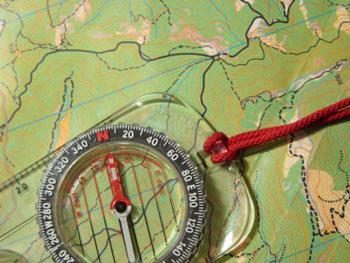
6 Kestrel Land Trust Page 6 / 10 Navigating with a Compass Cardinal directions: North 0 / 360 East 45 South 180 West 270 Two compass types: Azimuth (pictured top right) 0 to 360 All bearings count from zero, measuring clockwise from north (e.g., southwest is 225 ) Quadrant (pictured below right) 90 intervals (measured from north or south) Direction is specified as number of degrees east or west of either N or S (e.g., southwest is S 45 W). Notes Most survey maps use quadrant bearings. When using surveys, disregard minutes and seconds given in the bearings. Quadrant bearings can be converted to azimuth bearings and vice versa: S 45 W equals 180 plus 45 = 225 S 30 E would equal 180 minus 30 = 150. Key components of a compass: Needle The arrow (usually a red end) points to magnetic north. Housing (Dial) A movable circular dial with degrees marked on the outer edge. Each mark represents 2 degrees. Orienting Arrow An arrow-shaped outline within the housing (labeled here as Compass dial arrow ). This arrow will point north unless your compass is adjusted for declination. To follow a bearing, position the compass needle within this arrow (see page 9). Base Plate This is the part of the compass you hold in your hand. The front of the base plate has a direction of travel indicator (labeled here as Direction of travel arrow ). A compass with a sighting mirror will also have a direction of travel indicator at the top of the mirror.
7 Kestrel Land Trust Page 7 / 10 Navigating with a Compass Be aware of the different norths True north (star) a line from any point on the earth s surface to the geographic north pole. All lines of longitude are true north lines; they converge at a single point. It is common practice for maps to be oriented with true north at the top. Magnetic north (MN) the direction a compass points toward the magnetic north pole. Magnetic north is not a constant it varies depending on your geographic location (see illustration below). It also varies (slowly) over time. The difference between true north and magnetic north can be sufficient to take you well off course in the field (see Declination, below). Grid north (GN) a vertical line on a map that runs parallel to the prime meridian. Grid north lines do not converge at a single point. On a flat map, grid north lines do not follow true north lines, as true north follows the Earth's curved surface. For our purposes, the difference between true north and grid north is insignificant. Declination Declination is the difference between true north and magnetic north. Currently in our region, declination is approximately 14 west. To compensate for declination when you read a bearing off a map in our area, ADD 14 to the bearing. ( Declination west, compass best = add) You don t need to worry about declination if (1) your map uses magnetic north (surveyor s maps sometimes do), or (2) your compass is already set to account for declination and your map uses true north (most maps do). To adjust your compass for declination, rotate the compass housing with a screw and/or key provided with the compass. To adjust for west declination, rotate the orienting arrow counter-clockwise from 0 the number of degrees of declination (in our case, 14 ). The orienting arrow points to 346.
 along this line.")

8 Kestrel Land Trust Page 8 / 10 Navigating with a Compass How to Take a Compass Bearing from a Map Draw a straight line from your starting point over to the map edge in the direction you want to travel. Place the base plate of your compass (right or left edge) along this line. Turn the housing (dial) until the orienting arrow points N on the map (either aligned with map edge, or aligned with the north indicator on the map). Ignore the floating needle; focus only on the orienting arrow within the housing. Read the bearing and record it. Note: If your compass is not adjusted for declination and your map is oriented on true or grid north, add 14 to the bearing. Orienting arrow points N Ignore floating needle
. Hold the compass level in front of you approximately waist high (brace your elbows against your ribs to steady them).")
.")
9 Kestrel Land Trust Page 9 / 10 Navigating with a Compass How to Follow a Bearing EXAMPLE: 330 (azimuth compass) To set your bearing, turn the housing (dial) until 330 lines up with the direction of travel indicator on the compass base (see illustration, right). Hold the compass level in front of you approximately waist high (brace your elbows against your ribs to steady them). The direction of travel indicator should point straight ahead in front of you. Holding the compass steady and watching the dial, rotate your body until the compass needle is positioned within the orienting arrow outline. (see illustration, right). The red end of the needle should be at the pointing end of the orienting arrow. (This is known as putting red in the shed. ) Now you are facing the correct direction to travel. Look up and sight an object such as a tree or fencepost in that direction (the farther, the better). Then forget the compass temporarily and walk to that object. Remember to count paces if you need to (see page 4). When you arrive at your sighting object, repeat the process and pick out a new object to sight. Repeat until you reach your destination. How to Take a Bearing Bearing set to desired direction of travel Needle positioned within orienting arrow Face the point you want to determine. Hold the compass level in front of you approximately waist high (brace your elbows against your ribs to steady them). The direction of travel indicator should point straight ahead in front of you. Note: If you are using a compass with a sighting mirror your bearing will be more accurate if you hold the compass at eye level and use the mirror to read the dial. Keeping the direction of travel indicator pointed at your target, turn the dial until the compass needle is positioned within the orienting arrow outline. The red end of the needle should be at the pointing end of the orienting arrow. (This is known as putting red in the shed. ) Read the bearing at the direction of travel indicator. This will be the magnetic bearing if your compass is not adjusted for declination; it will be the true north bearing if your compass is adjusted for declination. Note: Compass readings are affected by the presence of iron and steel objects, including pocket knives, belt buckles, railroad tracks, trucks, electrical lines, etc.
Using Map and Compass Together
 Using Map and Compass Together In situations where you foresee a potential evacuation on foot, where there are no roads, and no indication as to the direction of travel (i.e., road signs), it is recommended
Compass Basics. Quick Map Basics Review For Compass Use
 Compass Basics Quick Map Basics Review For Compass Use A topographic map tells you where things are and how to get to them, whether you're hiking, biking, hunting, fishing, or just interested in the world
APPENDIX A GLOSSARY. Appendix A.1
 APPENDIX A GLOSSARY Appendix A.1 Appendix A.2 Back Bearing A back bearing is measured from the object to your position. It is the exact opposite of a direct bearing. Base Line An imaginary line on the
The Tacoma Mountaineers Wilderness Navigation
 The Tacoma Mountaineers Wilderness Navigation Navigation Fundamentals Navigation in mountainous terrain and wilderness areas requires a set of skills, of which using a map and compass is only one part.
Topographic Map Series:
 DEFINITION OF A MAP A MAP IS A GEOGRAPHIC PREPRESENTATION OF A PORTION OF THE EARTH S SURFACE DRAWN TO SCALE, AS SEEN FROM ABOVE. IT S USES COLORS, SYMBOLS AND LABELS TO REPRESENT FEATURES FOUND ON THE
Orienteering Maps & Map Reading Latitude and Longitude Scale
 Orienteering Maps & Map Reading A map is a two-dimensional representation of the three-dimensional world you'll be hiking in. All maps will have some basic features in common and map reading is all about
How to Use a Compass with a USGS Topographic Map
 How to Use a Compass with a USGS Topographic Map METHOD #1: (these directions assume your orienting arrow lines up with the North indicator on your compass dial, meaning the compass has not been adjusted
USING THE MILITARY LENSATIC COMPASS
 USING THE MILITARY LENSATIC COMPASS WARNING This presentation is intended as a quick summary, and not a comprehensive resource. If you want to learn Land Navigation in detail, either buy a book; or get
Chapter 3 Models of the Earth. 3.1 Finding Locations on the Earth. 3.1 Objectives
 Chapter 3 Models of the Earth 3.1 Finding Locations on the Earth 3.1 Objectives Explain latitude and longitude. How can latitude and longitude be used to find locations on Earth? How can a magnetic compass
Navigating with Map & Compass. Nevada County Sheriff s Search & Rescue
 Navigating with Map & Compass Nevada County Sheriff s Search & Rescue Objectives Very Practical Teach you how to go from point A to point B Go from the wilderness (real world) to a map and visa versa Agenda
What is a map? Understanding your map needs
 What is a map? A map is simply a drawing or picture of a landscape or location. Maps usually show the landscape as it would be seen from above, looking directly down. As well as showing the landscape of
BUSH NAV BUSH NAV DAY Navigation for Bush Navigation Day. November. WhitehorseD AY. Section 1 Registration, Maps & Checkpoints
 BUSH DAY Navigation for Bush Navigation Day Robert Kirwan, Nunawading SES W NW N NE E If you have little or no bush navigation experience then you will have been teamed up with members that have that experience
What is a map? A Map is a two or three-dimensional model or representation of the Earth s surface. 2-Dimensional map
 What is a map? A Map is a two or three-dimensional model or representation of the Earth s surface. 2-Dimensional map What is a Map Projection? Planar Projection Projection A Projection is a mathematical
Red Star Navigation. Bearings:
 Red Star Navigation Bearings: The main focus in Red Star Navigation is how to use a compass and in particular compass bearings. It is important for cadets to describe bearings as this will assist them
Chapter 3 SECTION 1 OBJECTIVES
 Chapter 3 SECTION 1 OBJECTIVES Distinguish between latitude and longitude and locate coordinates on maps. Explain how latitude and longitude can be used to locate places on Earth s surface. Explain the
Lesson 3: Locating Plots on the Ground
 Review and Introduction Lesson 3: Locating Plots on the Ground So far, you have identified individual stands in the forest, learned about plot sampling, and marked locations on a map of where your inventory
Butte County Fire Department
 Butte County Fire Department Basic Land Navigation Verification Sheet I verify that Print Supervisor s name has completed the Print Employee s name Basic Land Navigation self study guide on. Date Attached
Navigating for Scouts A Self-teaching Guide to Navigation with Map and Compass
 Don Burgess, November 2003 Materials topographic maps Navigating for Scouts A Self-teaching Guide to Navigation with Map and Compass metric ruler orienteering compass 30 M/5 Hamilton-Burlington 41 I/13
B. Topographic maps are also called. contour maps
 Topographic Maps Introduction A. Topographic maps are essential tools in geologic and engineering studies because they show the configuration of Earth's surface in remarkable detail and permit one to measure
Topographic Maps and Landforms Geology Lab
 Topographic Maps and Landforms Geology Lab Ray Rector: Instructor Today s Lab Activities 1) Discussion of Last Week s Lab 2) Lecture on Topo Maps and Elevation Contours 3) Construct Topographic Maps and
AS 410 Land Navigation. Chpt 4-1
 AS 410 Land Navigation Chpt 4-1 Overview Types of Maps Map Legends / Scales Latitude and Longitude Orienteering Why? Why important to learn how to read a compass and map? No cell phone coverage Mountain
Topographic Maps. Take Notes as you view the slides
 Topographic Maps Take Notes as you view the slides Lesson Objectives Define a topographic map and state its uses. Describe how contour lines show the elevations, shape, and slope of the land. Identify
How to Use a Compass
 How to Use a Compass The compass consists of a magnetized metal needle that floats on a pivot point. The needle orients to the magnetic field lines of the earth. The basic orienteering compass is composed
In order to be adequately prepared for a test on this topic you should be able to:-
 Topic 2: MAPPING In order to be adequately prepared for a test on this topic you should be able to:- 1. Find and also provide both FOUR and SIX figure Area and Grid References 2. Calculate distances both
Earth Science Regents Reading Topographic Maps
 Earth Science Regents Reading Topographic Maps Name Period Quick Tutorial on Degrees, Minutes, and Seconds of Latitude and Longitude A degree of latitude on the surface of the earth is about 70 miles long.
Latitude and Longitude
 U n i t 3 M a p p i n g P a g e 1 Latitude and Longitude Note: These coordinates are always expressed LATITUDE/LONGITUDE!!! Coordinate System: Using and to find your position on Earth. LATITUDE LATITUDE
Basic Field Instruments Field Orientation, Basic Navigation ESRM 304
 Basic Field Instruments Field Orientation, Basic Navigation ESRM 304 Three Basic Navigation Measurements Direction Distance Elevation (or change in it) 2 Compass for Direction Looking from point to point,
APPENDIX F PRE-COURSE WORK
 APPENDIX F PRE-COURSE WORK F-1 Pre-Course Work F-2 Pre-Course Work Intermediate Wildland Fire Behavior, S-290 Pre-Course Work The pre-course work is designed to ensure that students come to class with
Butte County Fire Department
 Butte County Fire Department Basic Land Navigation Verification Sheet I verify that Print Supervisor's name Print Employee's name has completed the Basic Land Navigation self study guide on Date Attached
California Cadet Corps Curriculum on Maps and Navigation. Map Reading LEADERS KNOW THE WAY
 California Cadet Corps Curriculum on Maps and Navigation Map Reading LEADERS KNOW THE WAY 5/22/2017 Map Reading Agenda A1. Introduction to Maps A2. Topographical Map Basics A3. Elevation and Terrain Features
Geology 101 Lab Worksheet: Topographic Maps
 Geology 101 Lab Worksheet: Topographic Maps Name: Refer to the Topographic Maps Lab for the information you need to complete this worksheet (http://commons.wvc.edu/rdawes/g101ocl/labs/topomapslab.html).
The Navigator s Dozen
 www.meadowsdofe.org.uk leaders@meadowsdofe.org.uk The Navigator s Dozen The 12 most important mountain navigation skills 1. Symbols and Grid References 1 2. Map scales and measuring distances 2 3. Setting
EROSIONAL FEATURES. reflect
 reflect Have you ever looked at the land around you and wondered what processes shaped what you see? Perhaps you see mountains, valleys, rivers, or canyons. Do you know how long these geologic features
Topographic Maps. More than a Road Map
 Topographic Maps More than a Road Map What is a Topographic Map? Scaled representation of features on the surface of the Earth such as roads, rivers, and plains Provides information about land elevations
Activities: Map and Compass
 Activities: Map and Compass Determining General Directions Modified with permission from Outdoor Living Skills Series: Map and Compass, Missouri Department of Conservation Overview: Students use the sun
Basic Map Skills for the Outdoors
 Geography 80-20 80% of what there is to know, for 20% of the sweat Basic Map Skills for the Outdoors Map Scale Map source: US Geological Survey Four ways to indicate map scale: Representative fraction
Erosional Features. What processes shaped this landscape?
 Have you ever looked at the land around you and wondered what processes shaped what you see? Perhaps you see mountains, valleys, rivers, or canyons. Do you know how long these geologic features have been
Mapping Earth. How are Earth s surface features measured and modeled?
 Name Mapping Earth How are Earth s surface features measured and modeled? Before You Read Before you read the chapter, think about what you know about maps Record your thoughts in the first column Pair
The ABC's of Compass and Map STUDENT WORKBOOK
 The ABC's of Compass and Map STUDENT WORKBOOK 1 EXERCISE 1: Compass Part Identification Directions: Match the terms below with the correct parts on the compass diagram. NOTES: A. Azimuth Ring B. Compass
King County Explorer Search and Rescue. Course B Map & Compass
 King County Explorer Search and Rescue Course B Map & Compass Disclaimer The intent of this presentation is to provide a basic overview of maps, compasses, and location finding. It is not meant to be a
HWA CHONG INSTITUTION NATIONAL POLICE CADET CORPS TOPOGRAPHY AND ORIENTEERING. Topography and Orienteering
 Topography and Orienteering 1. Introduction Orienteering is about using a topographic map and compass to find points in the landscape. It is fun and challenging, as one would need to take reference to
In such cases, direction may be used for the location of a point by any of the following methods:
 COMPASS SURVEYING Surveying is concerned with the relative location of points on, above or below the surface of the earth. It therefore becomes necessary to start from known points on a line. If the location
USING THE MILITARY LENSATIC COMPASS
 USING THE MILITARY LENSATIC COMPASS WARNING This presentation is intended as a quick summary, and not a comprehensive resource. If you want to learn Land Navigation in detail, either buy a book; or get
OA Guide to Map & Compass. The Backpacker's Field Manual by Rick Curtis
 OA Guide to Map & Compass part of The Backpacker's Field Manual by Rick Curtis Published by Random House 1998 This material is taken from Chapter 6 - Wilderness Travel from The Backpackers Field Manual
56H. This system allows definition of points on the Earth s surface to within 100 meters. Page 20. Navigation Systems Basics of Maps
 Grid References Many maps are provided with the standard grid overlaying them. This provides a simple and accurate method for finding features on the map. It is a network of intersecting parallel lines
Your Silva Ranger Compass is a precision instrument made by experienced
 RANGER COMPASS model: 515 A PRECISION INSRUMEN DESIGNED FOR PROFESSIONAL USE. INSRUCION MANUAL Your Silva Ranger Compass is a precision instrument made by experienced specialists in this field; it is the
GPS Measurement Protocol
 GPS Measurement Protocol Purpose To determine the latitude, longitude, and elevation of your school and of all your GLOBE sites Overview The GPS receiver will be used to determine the latitude, longitude
ANSWER SHEET PART 1 BASIC LAND NAVIGATION
 ANSWER SHEET PART 1 BASIC LAND NAVIGATION 1. Knowing these four basic skills, it is impossible to be totally lost; what are they? a. Track Present Location / Determine Distance / Sense of Direction / How
REVISION: MAPWORK 18 SEPTEMBER 2014
 REVISION: MAPWORK 18 SEPTEMBER 2014 Lesson Description In this lesson we revise: Various mapwork calculations Summary Relative Position Bearing is the angular (angle) distance between two points True Bearing
Practice Packet Topic 2: Measuring Earth
 Practice Packet Topic 2: Measuring Earth Vocabulary: Lesson 1: Lesson 2: Name: Lesson 3: Mini Lesson: Latitude Longitude Pre-Test 1. To locate exact places on the earth, one must look at a. The intersecting
EARTH SCIENCE KEY UNIT 2-H
 EARTH SCIENCE KEY UNIT 2-H UNIT 2 MODELS & DIMENSIONS OF EARTH I. Model = ANYTHING THAT REPRESENTS THE PROPERTIES OF AN OBJECT OR SYSTEM A. Types and examples of models: 1. PHYSICAL Provides us with information
Homework - Topographic Maps and What They Mean - Standard Earth Science
 Name: Mr. Schwartz Earth Science Period: Date: /10 Homework - Topographic Maps and What They Mean - Standard Earth Science Read pages 46-47 and 53-56 in your text. Then, answer the questions. Don t forget
Date: UNI. world. *Dedicated to
 Name: Date: UNI IT THREE 2D and 3D model s of the natural world *Dedicated to Name: Date: ABSTRACT T AND RATIONALE A topographic map is a type of map that depicts the detail and quantitative representation
MAPPING THE EARTH HOW DO YOU FIND A LOCATION ON THE EARTH?
 MAPPING THE EARTH HOW DO YOU FIND A LOCATION ON THE EARTH? UNIT TOPICS TOPIC 1: LATITUDE & LONGITUDE TOPIC 2: FIELD MAPS TOPIC 3: TOPOGRAPHIC MAPS TOPIC 4: NYS LANDSCAPES TOPIC 1: LATITUDE & LONGITUDE
Navigation. A question. Take a map and remove the actual map and what are you left with?
 Map reading is part art and part skill. The art comes from practice and the skill from following a few simple rules. Here BGMA will take a step-by-step look at how to become a good (dare we say, skilled)
PART 2 INTERMEDIATE LAND NAVIGATION
 PART 2 INTERMEDIATE LAND NAVIGATION USING THE MILITARY LENSATIC COMPASS WARNING This presentation is intended as a quick summary, and not a comprehensive resource. If you want to learn Land Navigation
Lab Topographic Maps. Name: Partner: Purpose. Background Information
 Lab Topographic Maps Name: Partner: Purpose The purpose of this lab is to familiarize you with graphic representations of the Earth s surface primarily maps. Simple line maps show the spatial relationship
Regents Earth Science Unit 1 Earth Dimensions
 Regents Earth Science Unit 1 Earth Dimensions www. BarnesWeb.org 2014-15 edition Name: Name: OBJECTIVES Correctly define: isolines, gradient, topographic map, contour interval, hachured lines, profile,
Notes and Summary pages:
 Topographic Mapping 8.9C Interpret topographical maps and satellite views to identify land and erosional features and predict how these shapes may be reshaped by weathering ATL Skills: Communication taking
Engineering Surveying -1 CE212 Compass Surveying
 Engineering Surveying -1 CE212 Compass Surveying Lecture 2016, September 03-04 Muhammad Noman Compass Surveying Chain surveying can be used when the area to be surveyed is comparatively is small and is
USING THE MILITARY LENSATIC COMPASS
 USING THE MILITARY LENSATIC COMPASS WARNING This presentation is intended as a quick summary, and not a comprehensive resource. If you want to learn Land Navigation in detail, either buy a book; or get
Road Scholar. Williamette Valley Invitational Practice Tournament
 Road Scholar Williamette Valley Invitational Practice Tournament Rules for this Event As you complete this event, enter your answers on the online data sheet. You may click "submit" when done and quietly
Charts and Chart Work with Poole Sailing
 with Poole Sailing Nautical charts are a mine of information but they need to be up to date. Corrections to charts are published by the Hydrographic Office monthly as Notices to Mariners both in print
Map and Compass Skills
 Map and Compass Skills Grade levels: 5-12 In a Nutshell Given a map and compass, students will be able to find a location on the map, chart a course to that location with the compass, and find that location
ORIENTEERING. The challenge is to use the map to decide the best route to complete the course in the quickest time. Orienteering Map. Compass.
 ORIENTEERING Orienteering is similar to a cross-country race but you navigate using a map instead of following a set course. It is an outdoor sport where competitors navigate their own way, you can run,
Applied Geomorphology. Pocket Transit Survey Methods
 Applied Geomorphology Pocket Transit Survey Methods The Pocket Transit (Brunton) Used to measure compass directions Allows for magnetic declination correction Can measure vertical angles with clinometer.
CHAPTER EXIT CHAPTER. Models of Earth. 3.1 Modeling the Planet. 3.2 Mapmaking and Technology. 3.3 Topographic Maps CHAPTER OUTLINE
 EXIT CHAPTER.1 Modeling the Planet.2 Mapmaking and Technology. Topographic Maps CHAPTER OUTLINE CHAPTER.1 Modeling the Planet A flat of Earth is a convenient tool, but it can distort the shape, distance,
Army Cadet Navigation
 Army Cadet Navigation Chapter 1-Using a Map Chapter 2-Using a Compass Chapter 3- Using a GPS Chapter 4- Navigating In Winter Types of Maps: 2 Map Care 3 Marginal Information 5 Conventional Signs 6 Contour
Laboratory Exercise #2 Introduction to Quadrangle Maps
 page - 1 Laboratory Exercise #2 Introduction to Quadrangle Maps A. Introduction to Quadrangle Maps The United States Geological Survey has developed a nationwide series of quadrangle maps that cover small
CONTOUR MAPS This Enrichment4You e-guide provides a brief overview of contour maps In this e-guide you will: Sample file
 GEOLOGY CONTOUR MAPS CONTOUR MAPS This Enrichment4You e-guide provides a brief overview of contour maps In this e-guide you will: *Learn Basic Facts About Contour Maps *Make a 3-D Contour Map Geology Contour
Chapter 1 Overview of Maps
 Chapter 1 Overview of Maps In this chapter you will learn about: Key points when working with maps General types of maps Incident specific maps Map legend and symbols Map sources A map is a navigational
Map reading notes. It is a very useful kind of map that shows the topography of an area, i.e whether it is flat, undulating, rugged or mountainous
 Introduction Map reading notes In the course of 2 or 3 years course, Candidates will be exposed to topographical maps from tropical countries such as Mauritius, Tanzania, Zimbabwe and Jamaica. Many of
Advanced Vectors. Table of Contents
 Advanced Vectors Table of Contents I. Location and Distance on Earth 2 Introduction Determining Latitude Latitude and the North Star Determining Longitude Longitude and Time Using Earth's Grid System Google
STAAR Science Tutorial 40 TEK 8.9C: Topographic Maps & Erosional Landforms
 Name: Teacher: Pd. Date: STAAR Science Tutorial 40 TEK 8.9C: Topographic Maps & Erosional Landforms TEK 8.9C: Interpret topographic maps and satellite views to identify land and erosional features and
Laboratory Exercise #2 Introduction to Quadrangle Maps
 page - Laboratory Exercise #2 Introduction to Quadrangle Maps A. Introduction to Quadrangle Maps The United States Geological Survey has developed a nationwide series of quadrangle maps that cover small
Class Notes: Mapping the Earth
 Name: Date: Period: Mapping the Earth The Physical Setting: Earth Science Class Notes: Mapping the Earth I. Latitude and Longitude Map -! Latitude -! Also called These lines intersect Equator -! The North
Introduction to the Silva Ranger Compass. M. Helper, Jackson School of Geosciences, UT Austin
 Introduction to the Silva Ranger Compass Parts of the Silva Ranger Compass (Install Bull s Eye Level Here) Sighting Mirror Magnetic Needle with red North Sighting Notch Rotating Compass Card Clinometer
Guided Notes Topographic Maps
 Guided Notes Topographic Maps Map scale Straight line distance Curved line distance Rules of Isolines Contour Lines Hachured Lines Possible elevations Slope & Gradient Direction of River Flow Topographic
Wonder as you Wander up the Carding Mill Valley
 Wonder as you Wander up the Carding Mill Valley Spot clues to the 600 million year old history of the Long Mynd. Consider how the Earth has evolved since the rock you are walking over first formed. Welcome
Topographic Maps and Profiles
 Name: Date: Period: Earth Science Foundations The Physical Setting: Earth Science CLASS NOTES! Topographic Maps [contour maps] -! Topographic maps show three-dimensional shapes in two dimensions Elevation
OA Guide to Map & Compass - Part 1
 OA Guide to Map and Compass - Part 1 OA Guide to Map & Compass - Part 1 part of The Backpacker's Field Manual by Rick Curtis published by Random House 1998 Buy it now at Amazon.com This material is taken
ORIENTEERING I.E.S. JUANA DE CASTILLA ORIENTEERING. 3rd E.S.O. SECOND TERM P.E. DEPARTMENT
 3rd E.S.O. SECOND TERM 1 Orientation is the set of systems that allows us to recognize at all times: The situation of the cardinal points The place where we are The direction to take to reach the desired
LAND NAVIGATION 2-1. DEFINITION
 LAND NAVIGATION MAPS Cartography is the art and science of expressing the known physical features of the earth graphically by maps and charts. No one knows who drew, molded, laced together, or scratched
MILITARY TOPOGRAPHIC MAP II B170247XQ STUDENT HANDOUT
 UNITED STATES MARINE CORPS THE BASIC SCHOOL MARINE CORPS TRAINING COMMAND CAMP BARRETT, VIRGINIA 22134-5019 MILITARY TOPOGRAPHIC MAP II B170247XQ STUDENT HANDOUT Basic Officer Course Introduction Importance
Map Reading & Navigation
 60 Chapter 6 Map Reading & Navigation Navigation is a skill which allows you to determine your own position and the location of your destination, on a map or on the ground, and to plan and follow the best
***When doing the lab report write-up, be sure to follow the guidelines.***
 Topographic Maps Lab Vocabulary: topography - study of the shapes and features of the earth's surface elevation - height above sea level bench mark - a point that has been accurately measured for its position
1/28/16. EGM101 Skills Toolbox. Map types. Political Physical Topographic Climate Resource Road. Thematic maps (use one of the above as backdrop)
") EGM101 Skills Toolbox Map types Political Physical Topographic Climate Resource Road Thematic maps (use one of the above as backdrop) Map Types Deriving information from maps Hydrographic Geological Soils
EGM101 Skills Toolbox Map types Political Physical Topographic Climate Resource Road Thematic maps (use one of the above as backdrop) Map Types Deriving information from maps Hydrographic Geological Soils
 Chapter 2 Mapping Our World Picture: Mount Capulin, Raton, NM Cinder Cone Volcano ://3.bp.blogspot.com/_sKz1KwXRzcg/SzFzM52gIoI/AAAAAAAAABk/hguBAT80pk0/s320/capulin.jpg http://www.peteandmelissa.com/images/oklahoma/p1020190.jpg
11. ALPINE GLACIAL LANDFORMS
 Geomorphology 11. Alpine Glacial Landforms 11. ALPINE GLACIAL LANDFORMS 40 Points One objective of this exercise is for you be able to identify alpine glacial landforms and measure their characteristics.
Latitude and Longitude Pre Test
 Name Date Latitude and Longitude Pre Test Multiple Choice Directions: For questions, 1 10 circle the answer that letter that best answers the question. Each question is worth 1 point each. 1. To locate
Map Skills Unit. Note taking unit
 Map Skills Unit Note taking unit Introduction To learn about the Earth, we are going to learn about two geographic tools you can use.globes and maps. Globe A globe is a round model of the planet Earth
Topo Map Tidbits. Adapted from: An original Creek Connections activity. Creek Connections, Box 10, Allegheny College, Meadville, Pennsylvania, 16335
 Topo Map Tidbits Adapted from: An original Creek Connections activity. Creek Connections, Box 10, Allegheny College, Meadville, Pennsylvania, 16335 Introduction to Topographic Maps Grade Level: Basic Duration:
Parts of a Map. Map Skills. The Title. There are 4 main parts of a map: The Title The Compass Rose The Map Key The Scale
 Map Skills Parts of a Map There are 4 main parts of a map: The Title The Compass Rose The Map Key The Scale The Title The title of the map is usually at the top and describes the topic of the map Example:
Direction: the reference system
 Adapted from Liebenberg and Vlok 2000, The interpretation of maps, aerial photographs and satellite images. Direction: the reference system Direction provides us with one way of answering "Where?" questions.
Scientists observe the environment around them using their five senses.
 Earth Science Notes Topics 1: Observation and Measurement Topic 2: The Changing Environment Review book pages 1-38 Scientists observe the environment around them using their five senses. When scientists
Name Class Date. For each pair of terms, explain how the meanings of the terms differ.
 Skills Worksheet Chapter Review USING KEY TERMS For each pair of terms, explain how the meanings of the terms differ. 1. true north and magnetic north 2. latitude and longitude 3. equator and prime meridian
Topographic Maps Self-Instruction Lab (2016 edition) Geology 100 David Harbor s Section. 12 inches x 1 mile
 Geology 100 David Harbor s Section. 12 inches x 1 mile") Topographic Maps Name Self-Instruction Lab (2016 edition) Geology 100 David Harbor s Section Topographic maps are an important aid for a geologist, but maps are also useful for hikers, bicyclists, and
Topographic Maps Name Self-Instruction Lab (2016 edition) Geology 100 David Harbor s Section Topographic maps are an important aid for a geologist, but maps are also useful for hikers, bicyclists, and
Basic Land Navigation. Clark County Sheriff Core Comp Rev. # Land Navigation
 Basic Land Navigation Clark County Sheriff Core Comp Rev. # 2018 1 Land Navigation Requirement Through written evaluation the applicant will demonstrate knowledge of land navigation involved in Search
Structural Geology Lab. The Objectives are to gain experience
 Geology 2 Structural Geology Lab The Objectives are to gain experience 1. Drawing cross sections from information given on geologic maps. 2. Recognizing folds and naming their parts on stereoscopic air
Chapter 6 Mapping and Online Tools
 Chapter 6 Mapping and Online Tools The stream site you monitor is just part of a much larger system. When analyzing stream health, it is important to take a holistic view by considering the entire watershed.