Applied Geomorphology. Pocket Transit Survey Methods
|
|
|
- Charity Jones
- 5 years ago
- Views:
Transcription

1 Applied Geomorphology Pocket Transit Survey Methods
2 The Pocket Transit (Brunton) Used to measure compass directions Allows for magnetic declination correction Can measure vertical angles with clinometer.
 level 2.")
3 Components of the Pocket Transit 2.1: magnetic needle 2.2: graduated circle, azimuth or quadrant format 2.3: zero pin for setting magnetic declination 2.4: sighting arm 2.5: peep sight 2.6: mirror 2.7: round (bull s eye) level 2.8: clinometer scale (degrees and gradient) 2.9: clinometer level

4 Components of the Pocket Transit 2.10: magnetic declination set screw 2.11: clinometer adjustment lever 2.12: alidade mount

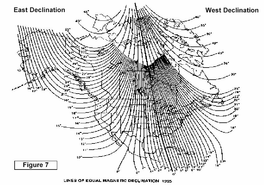
5 Magnetic Declination
6 Using the Pocket Transit The pocket transit is used to measure either compass directions (azimuth or bearing), or vertical angles An azimuth or bearing is measured by pointing the sighting arm toward the target while leveling the round level The north (usually white) end of the needle will indicate the azimuth or bearing

7 Measuring Direction Example
8 Pace Count Measurement Pace count is used to measure distance by counting the number of paces between two points Pace counts typically range between 2.3 and 3.3 feet per pace Combined with a pocket transit the pace count can be used to map the location of objects or collected samples
9 Pace Count Measurement cont. Average pace count (feet/pace) is determined by measuring the number of paces over at least 200 feet in 20 different trials. The average in feet per pace is used to calculate the pace count Trial No. Paces Dist. 200 ft. 200 ft. 200 ft. 200 ft. 200 ft. 200 ft. 200 ft. P.C ( PC i -Ave) ft Ave=2.09 n=0.0114
10 Pace Count Measurement cont. The precision of the pace count should be determined by calculating the standard deviation and % standard error Standard Deviation = n ( PC i Ave) 2 N-1 = = Standard Error % = ( 2 *(S.D.) ) * 100 Ave = (2*(0.040))*100 = 3.83% 2.09
11 Using the Pace Count Statistics A distance between to points measured 75 paces. What is the distance of the leg, and what is the accuracy of the estimate? Distance = No. Paces * Pace Count Average = 75 paces * 2.09 feet per pace = 157 feet (rounded to nearest foot) Accuracy = Distance * (Standard Error %)/100 = 157 feet * 3.83%/100 = 6.01 feet Therefore the distance and accuracy = 157 feet ± 6.01 feet
12 Pace & Compass Closed Traverse A pocket transit and pace count are used to track the position of sampling locations Use this method when a 1:24,000 topo. map is not sufficiently detailed The azimuth and pace from the last sample location to the starting location are taken to close the traverse Inevitable errors should be distributed around the traverse
13 Distributing the Error of a Closed traverse Error is distributed cumulatively through closed traverse 5/9 error vector original corrected Total error vector
14 Using the Clinometer The clinometer measures inclination angles when the pocket transit is held in a vertical plane The clinometer scale has 2 systems: Degrees: -90 to 0 to +90 Gradient: tan(slope angle) * 100% The clinometer may be set to 0 and then used as a level to sight points of equal elevation The clinometer is adjusted with a lever on the base of the instrument
15 Measuring the Height of an Object The clinometer may be combined with a measured distance to calculate the height of an object You must measure your eye height if you are using this method You will need a calculator that can process trig functions When measuring with the clinometer make sure to record the angle from the degree scale, not the gradient scale

16 Clinometer Geometry During Measurement
17 Hand-Leveling with Clinometer Need eye height measurement (inches) Set clinometer to 0 Holding pocket transit in a vertical plane sight to a point on the ground when the clinometer bubble is level Walk to the point sighted- this point is 1 eye-height elevation above the start point Bring a tape measure to measure the excess on the last measurement
18 Hand-Leveling Geometry Elev.Change= 3 x eye height excess = 3 x = 165 = ft. Excess= 30 Eye Ht.=65 inches
19 Other Clinometer Uses Direct Slope angle measurement- use a clipboard to average out the angle. Set the clinometer to 0 to level to a point of known elevation. Use a baseline to determine the position of an inaccessible point, and measure the height.
20 Baseline Method Clinometer angle y Az=050 Az=315 x Az=090 Horizontal triangle is set by scale and azimuth Y (height)= Tan (clinometer angle) ( X )
Last Time. GY 301: Geomorphology. Today s Agenda. Vertical Exaggeration UNIVERSITY OF SOUTH ALABAMA. Another Simple day; Topographic Profiles
 UNIVERSITY OF SOUTH ALABAMA GY 301: Geomorphology Lecture 5: Alidade & Plane Table Methods Last Time Another Simple day; Topographic profiles Drawing topographic profiles Vertical exaggeration Topographic
Basic Field Instruments Field Orientation, Basic Navigation ESRM 304
 Basic Field Instruments Field Orientation, Basic Navigation ESRM 304 Three Basic Navigation Measurements Direction Distance Elevation (or change in it) 2 Compass for Direction Looking from point to point,
Introduction to the Silva Ranger Compass. M. Helper, Jackson School of Geosciences, UT Austin
 Introduction to the Silva Ranger Compass Parts of the Silva Ranger Compass (Install Bull s Eye Level Here) Sighting Mirror Magnetic Needle with red North Sighting Notch Rotating Compass Card Clinometer
*1731* e) Define local attraction. State two causes of local attraction. f) State two principles of plane table survey. g) Define horizontal l
 Define local attraction. State two causes of local attraction. f) State two principles of plane table survey. g) Define horizontal l") *1731* 1731 21415 3 Hours/1 Marks S e a t o. Instructions : (1) All questions are compulsory. (2) Answer each next main question on a new page. (3) Illustrate your answers with neat sketches wherever necessary.
*1731* 1731 21415 3 Hours/1 Marks S e a t o. Instructions : (1) All questions are compulsory. (2) Answer each next main question on a new page. (3) Illustrate your answers with neat sketches wherever necessary.
Compass Basics. Quick Map Basics Review For Compass Use
 Compass Basics Quick Map Basics Review For Compass Use A topographic map tells you where things are and how to get to them, whether you're hiking, biking, hunting, fishing, or just interested in the world
71- Laxmi Nagar (South), Niwaru Road, Jhotwara, Jaipur ,India. Phone: Mob. : /
, Niwaru Road, Jhotwara, Jaipur ,India. Phone: Mob. : /") www.aarekh.com 71- Laxmi Nagar (South), Niwaru Road, Jhotwara, Jaipur 302 012,India. Phone: 0141-2348647 Mob. : +91-9799435640 / 9166936207 1. An invar tape made of an alloy of: A. Copper and steel. B.
www.aarekh.com 71- Laxmi Nagar (South), Niwaru Road, Jhotwara, Jaipur 302 012,India. Phone: 0141-2348647 Mob. : +91-9799435640 / 9166936207 1. An invar tape made of an alloy of: A. Copper and steel. B.
The Primary Trigonometric Ratios Word Problems
 The Primary Trigonometric Ratios Word Problems A. Determining the measures of the sides and angles of right triangles using the primary ratios When we want to measure the height of an inaccessible object
Map Reading & Compass Use
 Spring 2013 Kestrel Land Trust Page 2 / 10 Contents Map Basics... 3 Map Types... 3 Terrain Association... 4 Estimating Distance: Pacing... 4 Contour Lines... 5 Navigating with a Compass... 6 Compass Types...
UNIT-2 COMPASS SYRVEYING AND PLANE TABLE SURVEYING
 UNIT-2 COMPASS SYRVEYING AND PLANE TABLE SURVEYING THE PRISMATIC COMPASS Prismatic compass is the most convenient and portable of magnetic compass which can either be used as a hand instrument or can be
Objective questions for Practical Examination (CBCS scheme) Introduction to Surveying CE-112
 Introduction to Surveying CE-112") Objective questions for Practical Examination (CBCS scheme) Introduction to Surveying CE-112 1. The curvature of the earth s surface, is taken into account only if the extent of survey is more than i)
Objective questions for Practical Examination (CBCS scheme) Introduction to Surveying CE-112 1. The curvature of the earth s surface, is taken into account only if the extent of survey is more than i)
Measuring Trees Activity
 What is a Clinometer? Measuring Trees Activity It is an instrument for measuring slope angle of a line of sight. It is included in some compasses. How to make a Clinometer? Materials Needed: piece of cardboard
Day 6: Angles of Depression and Elevation. Unit 5: Trigonometric Functions
 + Day 6: Angles of Depression and Elevation Unit 5: Trigonometric Functions Warm Up + n Find the missing side length 1) 2) n Find the missing angle 10 minutes 3) 4) End + Homework Check + Today s Objective
In such cases, direction may be used for the location of a point by any of the following methods:
 COMPASS SURVEYING Surveying is concerned with the relative location of points on, above or below the surface of the earth. It therefore becomes necessary to start from known points on a line. If the location
Geometry Warm Up Right Triangles Day 8 Date
 Geometry Warm Up Right Triangles Day 8 Name Date Questions 1 4: Use the following diagram. Round decimals to the nearest tenth. P r q Q p R 1. If PR = 12 and m R = 19, find p. 2. If m P = 58 and r = 5,
T.4 Applications of Right Angle Trigonometry
 424 section T4 T.4 Applications of Right Angle Trigonometry Solving Right Triangles Geometry of right triangles has many applications in the real world. It is often used by carpenters, surveyors, engineers,
Sub. Code:
 (ISO/IEC - 700-005 Certified) Model Answer: Summer 08 Code: 05 Important Instructions to examiners: ) The answers should be examined by key words and not as word-to-word as given in the model answer scheme.
: SINE, COSINE, & TANGENT RATIOS
 Geometry Notes Packet Name: 9.2 9.4: SINE, COSINE, & TANGENT RATIOS Trigonometric Ratios A ratio of the lengths of two sides of a right triangle. For any acute angle, there is a leg Opposite the angle
#12 Algebra 2 Notes Using Trig in Real Life
 #12 Algebra 2 Notes 13.1 Using Trig in Real Life #12 Algebra 2 Notes: 13.1 using Trig in Real Life Angle of Elevation Angle of Elevation means you are looking upward and is usually measured from the ground
Activities: Map and Compass
 Activities: Map and Compass Determining General Directions Modified with permission from Outdoor Living Skills Series: Map and Compass, Missouri Department of Conservation Overview: Students use the sun
. For each problem you must set up equations, draw and label triangles, and answer the question(s) in a complete sentence
 in a complete sentence") Name Trig Tasks For these tasks, you have been hired by World Wide Engineering (WWE) and you will travel around the world to solve real life problems using trigonometry. You will be completing a series
Name Trig Tasks For these tasks, you have been hired by World Wide Engineering (WWE) and you will travel around the world to solve real life problems using trigonometry. You will be completing a series
Use a calculator to find the value of the expression in radian measure rounded to 2 decimal places. 1 8) cos-1 6
 cos-1 6") Math 180 - chapter 7 and 8.1-8. - New Edition - Spring 09 Name Find the value of the expression. 1) sin-1 0.5 ) tan-1-1 ) cos-1 (- ) 4) sin-1 Find the exact value of the expression. 5) sin [sin-1 (0.7)]
Math 180 - chapter 7 and 8.1-8. - New Edition - Spring 09 Name Find the value of the expression. 1) sin-1 0.5 ) tan-1-1 ) cos-1 (- ) 4) sin-1 Find the exact value of the expression. 5) sin [sin-1 (0.7)]
FOR 274 Assignment 3 [20 points] This assignment should be completed and handed at the start of lecture on Friday 16th September.
![FOR 274 Assignment 3 [20 points] This assignment should be completed and handed at the start of lecture on Friday 16th September.](/thumbs/90/101578770.jpg "FOR 274 Assignment 3 [20 points] This assignment should be completed and handed at the start of lecture on Friday 16th September.") FOR 274 Assignment 3 [20 points] Name: This assignment should be completed and handed at the start of lecture on Friday 16th September. 1. Convert the following bearings to azimuths: a. N35 W b. S22 E
FOR 274 Assignment 3 [20 points] Name: This assignment should be completed and handed at the start of lecture on Friday 16th September. 1. Convert the following bearings to azimuths: a. N35 W b. S22 E
Solving For Missing Angles Algebra 1
 Name: Solving For Missing ngles lgebra 1 Date: Today we will learn how to use right triangle trigonometry to find missing angles of a right triangle. In the first eercise, though, we will review how to
MAHARASHTRA STATE BOARD OF TECHNICAL EDUCATION (Autonomous) (ISO/IEC Certified)
 (ISO/IEC Certified)") (ISO/IEC - 270-23 Certified) WINTER 17 EXAMINATION Subject Name: SURVEYING Model wer Subject Code: 17310 Important Instructions to examiners: 1) The answers should be examined by key words and not as word-to-word
(ISO/IEC - 270-23 Certified) WINTER 17 EXAMINATION Subject Name: SURVEYING Model wer Subject Code: 17310 Important Instructions to examiners: 1) The answers should be examined by key words and not as word-to-word
Find the perimeter of the figure named and shown. Express the perimeter in the same unit of measure that appears on the given side or sides.
 Mth101 Chapter 8 HW Name Find the perimeter of the figure named and shown. Express the perimeter in the same unit of measure that appears on the given side or sides. 1) 1) Rectangle 6 in. 12 in. 12 in.
Geometry Review- Chapter Find e, and express your answer in simplest radical form.
 Name: Date: Period: Geometry Review- Chapter 10 1. The diagonal of a rectangle measures 15 cm long, and the width is 10. Find the height of the rectangle and epress your answer in simplest radical form.
Red Star Navigation. Bearings:
 Red Star Navigation Bearings: The main focus in Red Star Navigation is how to use a compass and in particular compass bearings. It is important for cadets to describe bearings as this will assist them
AU-5029 GURU GHASIDAS VISHWAVIDYALAYA, BILASPUR (C.G.) INSTITUTE OF TECHNOLOGY DEPARTMENT OF CIVIL ENGINEERING B.TECH
 INSTITUTE OF TECHNOLOGY DEPARTMENT OF CIVIL ENGINEERING B.TECH") AU-5029 GURU GHASIDAS VISHWAVIDYALAYA, BILASPUR (C.G.) INSTITUTE OF TECHNOLOGY DEPARTMENT OF CIVIL ENGINEERING B.TECH 2 nd YEAR, III rd SEMESTER SUBJECT: SURVEYING-I COURSE CODE: 21CE02T Max Marks: 60
AU-5029 GURU GHASIDAS VISHWAVIDYALAYA, BILASPUR (C.G.) INSTITUTE OF TECHNOLOGY DEPARTMENT OF CIVIL ENGINEERING B.TECH 2 nd YEAR, III rd SEMESTER SUBJECT: SURVEYING-I COURSE CODE: 21CE02T Max Marks: 60
Block 2 ~ The Pythagorean Theorem Self-Assessment. Progress (shade this in) Name Per. Track your understanding. Lesson #
 Name Per. Track your understanding. Lesson #") Block 2 ~ The Pythagorean Theorem Self-Assessment Track your understanding. Lesson # 2.1 2.2 2.3 2. 2. 2.7 Target I can recognize and find the values of perfect squares. I can estimate the value of square
Block 2 ~ The Pythagorean Theorem Self-Assessment Track your understanding. Lesson # 2.1 2.2 2.3 2. 2. 2.7 Target I can recognize and find the values of perfect squares. I can estimate the value of square
PREVIOUS YEAR SOLVED QUESTIONS SURVEYING - I. Unit - 1
 PREVIOUS YEAR SOLVED QUESTIONS SURVEYING - I Unit - 1 1. Distinguish between the following (June July 2015, June - July 2014, Dec 2013) i) Plane surveying: Curvature of earth is not taken into account.
Pre-Test. Use trigonometric ratios to find the value of x. Show all your work and round your answer to the nearest tenth.
 Pre-Test Name Date 1. Write the trigonometric ratios for A. Write your answers as simplified fractions. A 6 cm 10 cm sin A cos A 8 10 5 6 10 3 5 C 8 cm B tan A 8 6 3 2. Write the trigonometric ratios for
Lesson 3: Locating Plots on the Ground
 Review and Introduction Lesson 3: Locating Plots on the Ground So far, you have identified individual stands in the forest, learned about plot sampling, and marked locations on a map of where your inventory
1 Line Length I Bearing
 being 6 15'W. Calculate the true bearing of the line also error of closure and relative error of closure. 1 Line Length I Bearing AB 470m 343 52' BC 635 m 87 50' CD 430 m 172 40' DA 563 m 265 12' 9. (a)
Cleveland State University
 CVE 212 - Surveying Lab #1 MEASURING ANGLES & DISTANCES WITH A TOTAL STATION EQUIPMENT EDMI and Tripod Single prism mounted on a prism pole Field book Pencil 2 Walkie Talkies INTRODUCTION Recent developments
Surveying Prof. Bharat Lohani Indian Institute of Technology, Kanpur. Module 5 Lecture 1
 Surveying Prof. Bharat Lohani Indian Institute of Technology, Kanpur (Refer Slide Time: 00:20) Module 5 Lecture 1 Welcome to this another lecture on basic surveying. Today we are going to start a new module.
( 3 ) = (r) cos (390 ) =
 = (r) cos (390 ) =") MATH 7A Test 4 SAMPLE This test is in two parts. On part one, you may not use a calculator; on part two, a (non-graphing) calculator is necessary. When you complete part one, you turn it in and get part
MATH 7A Test 4 SAMPLE This test is in two parts. On part one, you may not use a calculator; on part two, a (non-graphing) calculator is necessary. When you complete part one, you turn it in and get part
II. COMPASS SURVEYING AND PLANE TABLE SURVEYING :
 1 II. COMPASS SURVEYING AND PLANE TABLE SURVEYING : Prismatic compass surveyor s compass bearing system of conversions Local attraction magnetic declination Dip Traversing Plotting Adjustment of errors
Cleveland State University
 CVE 212 - Surveying Lab #6 MEASURING ISTANCES USING STAIA METHOS EQUIPMENT Transit or theodolite with stadia hairs and tripod Philadelphia leveling rod Field book No. 3 drafting pencil INTROUCTION When
A) 13 B) 9 C) 22 D) log 9
 13 B) 9 C) 22 D) log 9") Math 70 Exam 2 Review Name Be sure to complete these problems before the review session. Participation in our review session will count as a quiz grade. Please bring any questions you have ready to ask!
Math 70 Exam 2 Review Name Be sure to complete these problems before the review session. Participation in our review session will count as a quiz grade. Please bring any questions you have ready to ask!
Unit 3 Right Triangle Trigonometry - Classwork
 Unit 3 Right Triangle Trigonometry - Classwork We have spent time learning the definitions of trig functions and finding the trig functions of both quadrant and special angles. But what about other angles?
Math 370 Exam 2 Review Name
 Math 70 Exam 2 Review Name Be sure to complete these problems before the review session. 10 of these questions will count as a quiz in Learning Catalytics. Round 1 will be individual. Round 2 will be in
Group/In-Class Exercises 8/18/09 g0401larson8etrig.tst 4.1 Radian and Degree Measure
 Group/In-Class Exercises 8/8/09 g040larson8etrig.tst 4. Radian and Degree Measure Name MULTIPLE CHOICE. Choose the one alternative that best completes the statement or answers the question. The given angle
Trigonometry Final Exam Review
 Name Period Trigonometry Final Exam Review 2014-2015 CHAPTER 2 RIGHT TRIANGLES 8 1. Given sin θ = and θ terminates in quadrant III, find the following: 17 a) cos θ b) tan θ c) sec θ d) csc θ 2. Use a calculator
DETERMINATION OF AREA OF POLYGON BY CHAIN AND CROSS STAFF SURVEY 1. AIM:
 Expt. No: 2 Date: DETERMINATION OF AREA OF POLYGON BY CHAIN AND CROSS STAFF SURVEY 1. AIM: To determine the area of a given field with define boundary by conducting cross staff survey. 2. INSTRUMENTS REQUIRED:
WATTS MICROPTIC ALIDADE OPERATING INSTRUCTIONS 20-7
 WATTS MICROPTIC ALIDADE 20-7 OPERATING INSTRUCTIONS WATTS Operating Instructions for the WATTS MICROPTIC ALIDADE SA100 SA101 RANK PRECISION INDUSTRIES METROLOGY DIVISION Survey Equipment Sales Langston
Mth 133 Trigonometry Review Problems for the Final Examination
 Mth 1 Trigonometry Review Problems for the Final Examination Thomas W. Judson Stephen F. Austin State University Fall 017 Final Exam Details The final exam for MTH 1 will is comprehensive and will cover
; approximate b to the nearest tenth and B or β to the nearest minute. Hint: Draw a triangle. B = = B. b cos 49.7 = 215.
 M 1500 am Summer 009 1) Given with 90, c 15.1, and α 9 ; approimate b to the nearest tenth and or β to the nearest minute. Hint: raw a triangle. b 18., 0 18 90 9 0 18 b 19.9, 0 58 b b 1.0, 0 18 cos 9.7
Chapter 2. Altitude Measurement
 Chapter Altitude Measurement Although altitudes and zenith distances are equally suitable for navigational calculations, most formulas are traditionally based upon altitudes which are easily accessible
Butte County Fire Department
 Butte County Fire Department Basic Land Navigation Verification Sheet I verify that Print Supervisor s name has completed the Print Employee s name Basic Land Navigation self study guide on. Date Attached
The Primary Trigonometric Ratios Word Problems
 . etermining the measures of the sides and angles of right triangles using the primary ratios When we want to measure the height of an inaccessible object like a tree, pole, building, or cliff, we can
Trigonometry Exam II Review Problem Selected Answers and Solutions
 Trigonometry Exam II Review Problem Selected Answers and Solutions 1. Solve the following trigonometric equations: (a) sin(t) = 0.2: Answer: Write y = sin(t) = 0.2. Then, use the picture to get an idea
8-1 Geometric Mean. SOLUTION: We have the diagram as shown.
 25. CCSS MODELING Makayla is using a book to sight the top of a waterfall. Her eye level is 5 feet from the ground and she is a horizontal distance of 28 feet from the waterfall. Find the height of the
MATH 115 Precalculus Spring, 2015, V1.2
 MULTIPLE CHOICE 1. Solve, and express the answer in interval notation: 6 5x 4. 1. A. (, 2] [2/5, ) B. [2/5, 2] C. (, 2/5] D. (, 2/5] [2, ) 2. Which of the following polynomials has a graph which exhibits
Set up equations to find the lengths of the sides labeled by variables, and Find answers to the equations x. 19 y a a b.
 SHADOWS After Day 10 SIMILAR POLYGONS In each of the pairs of figures below, assume the figures are similar and that they are facing the same way; that is, assume that the left side of one corresponds
Radicals and Pythagorean Theorem Date: Per:
 Math 2 Unit 7 Worksheet 1 Name: Radicals and Pythagorean Theorem Date: Per: [1-12] Simplify each radical expression. 1. 75 2. 24. 7 2 4. 10 12 5. 2 6 6. 2 15 20 7. 11 2 8. 9 2 9. 2 2 10. 5 2 11. 7 5 2
Essential Question How can you find a trigonometric function of an acute angle θ? opp. hyp. opp. adj. sec θ = hyp. adj.
 . Right Triangle Trigonometry Essential Question How can you find a trigonometric function of an acute angle? Consider one of the acute angles of a right triangle. Ratios of a right triangle s side lengths
22X Builder s Transit Level Model No Instruction Manual
 2595H 7/29/09 10:15 AM Page 1 22X Builder s Transit Level Model No. 40-6910 Instruction Manual Congratulations on your choice of this 22X Builder s Transit Level. We suggest you read this instruction manual
New Rochelle High School Geometry Summer Assignment
 NAME - New Rochelle High School Geometry Summer Assignment To all Geometry students, This assignment will help you refresh some of the necessary math skills you will need to be successful in Geometry and
How to Use a Compass with a USGS Topographic Map
 How to Use a Compass with a USGS Topographic Map METHOD #1: (these directions assume your orienting arrow lines up with the North indicator on your compass dial, meaning the compass has not been adjusted
Engineering Surveying -1 CE212 Compass Surveying
 Engineering Surveying -1 CE212 Compass Surveying Lecture 2016, September 03-04 Muhammad Noman Compass Surveying Chain surveying can be used when the area to be surveyed is comparatively is small and is
GIET COLLEGE OF ENGINEERING DEPARTMENT OF CIVIL ENGINEERING SURVEYING LAB MANUAL FAMILARITY WITH INSTRUMENTS USED IN CHAIN SURVEYING
 GIET COLLEGE OF ENGINEERING DEPARTMENT OF CIVIL ENGINEERING SURVEYING LAB MANUAL FAMILARITY WITH INSTRUMENTS USED IN CHAIN SURVEYING OBJECTIVE: Study of various instruments used in chain surveying and
 VALLIAMMAI ENGINEERING COLLEGE Department of Civil Engineering CE6304 SURVEYING I Questions Bank UNIT-I FUNDAMENTALS AND CHAIN SURVEYING Part A 1) Define surveying. 2) What are the types of surveying?
8.6 Inverse Trigonometric Ratios
 www.ck12.org Chapter 8. Right Triangle Trigonometry 8.6 Inverse Trigonometric Ratios Learning Objectives Use the inverse trigonometric ratios to find an angle in a right triangle. Solve a right triangle.
Using the distance formula Using formulas to solve unknowns. Pythagorean Theorem. Finding Legs of Right Triangles
 Math 154 Chapter 9.6: Applications of Radical Equations Objectives: Finding legs of right triangles Finding hypotenuse of right triangles Solve application problems involving right triangles Pythagorean
Math 1201 Review Chapter 2
 Math 01 Review hapter 2 Multiple hoice Identify the choice that best completes the statement or answers the question. 1. etermine tan Q and tan R. P Q 16 R a. tan Q = 0.428571; tan R = 0.75 c. tan Q =
Butte County Fire Department
 Butte County Fire Department Basic Land Navigation Verification Sheet I verify that Print Supervisor's name Print Employee's name has completed the Basic Land Navigation self study guide on Date Attached
UNIT-4 THEODOLITE SURVEYING
 UNIT-4 THEODOLITE SURVEYING The Theodolite The measurement of horizontal and vertical angles and it is the most precise instrument designed for points on line, prolonging survey lines, establishing grades,
Your Silva Ranger Compass is a precision instrument made by experienced
 RANGER COMPASS model: 515 A PRECISION INSRUMEN DESIGNED FOR PROFESSIONAL USE. INSRUCION MANUAL Your Silva Ranger Compass is a precision instrument made by experienced specialists in this field; it is the
Final Exam Review Packet
 Final Exam Review Packet Multiple Choice Identify the choice that best completes the statement or answers the question. 1. Find the length of the missing side. The triangle is not drawn to scale. 6 8 a.
David C. Pow ell, Silviculturist
 Using Mathematics in Forestry 1 David C. Pow ell, Silviculturist Most jobs require good mathematics skills, and forestry is no exception. The exercises in this handout will show you some of the ways that
Trigonometry Project Student Package
 Trigonometry Project Student Package AWM11 Name: Date: What I can do in this unit 4-1a Label a right triangle with Opposite, Adjacent, and Hypotenuse. Level 4-1b Solve for side lengths of right triangles
NCEES FS Practice Exam
 NCEES FS Practice Exam Terrametra Resources Lynn Patten 1. One corner of a 60-ft. 120-ft. lot, otherwise rectangular, is a curve with a radius of 20 ft. and a central angle of 90. The area (ft. 2 ) of
APPENDIX A GLOSSARY. Appendix A.1
 APPENDIX A GLOSSARY Appendix A.1 Appendix A.2 Back Bearing A back bearing is measured from the object to your position. It is the exact opposite of a direct bearing. Base Line An imaginary line on the
DHANALAKSHMI COLLEGE OF ENGINEERING Manimangalam, Tambaram, Chennai
 DHANALAKSHMI COLLEGE OF ENGINEERING Manimangalam, Tambaram, Chennai 601 301 DEPARTMENT OF CIVIL ENGINEERING CE6311 SURVEY PRACTICAL I III SEMESTER R 2013 LABORATORY MANUAL Name : Register No. : Class :
5. What is not typically considered to be a cause of natural error when using EDM devices?
 Student ID: 22093585 Exam: 498868RR - Introduction to Surveying and Measurement When you have completed your exam and reviewed your answers, click Submit Exam. Answers will not be recorded until you hit
Using Map and Compass Together
 Using Map and Compass Together In situations where you foresee a potential evacuation on foot, where there are no roads, and no indication as to the direction of travel (i.e., road signs), it is recommended
Name Date Trigonometry of the Right Triangle Class Work Unless otherwise directed, leave answers as reduced fractions or round to the nearest tenth.
 Name Date Trigonometry of the Right Triangle Class Work Unless otherwise directed, leave answers as reduced fractions or round to the nearest tenth. 1. Evaluate the sin, cos, and tan of θ(theta). 2. Evaluate
COPYRIGHTED MATERIAL INTRODUCTION CHAPTER 1
 CHAPTER 1 INTRODUCTION 1.1 INTRODUCTION We currently live in what is often termed the information age. Aided by new and emerging technologies, data are being collected at unprecedented rates in all walks
Leveling. 3.1 Definitions
 Leveling 3.1 Definitions Leveling is the procedure used to determine differences in elevation between points that are remote from each other. Elevation is a vertical distance above or below a reference
Warm Up 1. What is the third angle measure in a triangle with angles measuring 65 and 43? 72
 Warm Up 1. What is the third angle measure in a triangle with angles measuring 65 and 43? 72 Find each value. Round trigonometric ratios to the nearest hundredth and angle measures to the nearest degree.
5.5 Special Rights. A Solidify Understanding Task
 SECONDARY MATH III // MODULE 5 MODELING WITH GEOMETRY 5.5 In previous courses you have studied the Pythagorean theorem and right triangle trigonometry. Both of these mathematical tools are useful when
Total station LEICA TPS
 Total station LEICA TPS405 200 The perfect solution for all sites Rugged, adaptable total station with accurate angle measurements, dual-axis compensator, powerful EDM, data output in any format, and application
[1] [2.3 b,c] [2] [2.3b] 3. Solve for x: 3x 4 2x. [3] [2.7 c] [4] [2.7 d] 5. Solve for h : [5] [2.4 b] 6. Solve for k: 3 x = 4k
![[1] [2.3 b,c] [2] [2.3b] 3. Solve for x: 3x 4 2x. [3] [2.7 c] [4] [2.7 d] 5. Solve for h : [5] [2.4 b] 6. Solve for k: 3 x = 4k](/thumbs/78/77023587.jpg "[1] [2.3 b,c] [2] [2.3b] 3. Solve for x: 3x 4 2x. [3] [2.7 c] [4] [2.7 d] 5. Solve for h : [5] [2.4 b] 6. Solve for k: 3 x = 4k") 1. Solve for x: 4( x 5) = (4 x) [1] [. b,c]. Solve for x: x 1.6 =.4 +. 8x [] [.b]. Solve for x: x 4 x 14 [] [.7 c] 4. Solve for x:.x. 4 [4] [.7 d] 5. Solve for h : 1 V = Ah [5] [.4 b] 6. Solve for k: x
1. Solve for x: 4( x 5) = (4 x) [1] [. b,c]. Solve for x: x 1.6 =.4 +. 8x [] [.b]. Solve for x: x 4 x 14 [] [.7 c] 4. Solve for x:.x. 4 [4] [.7 d] 5. Solve for h : 1 V = Ah [5] [.4 b] 6. Solve for k: x
Chapter 2: Trigonometry
 Chapter 2: Trigonometry Section 2.1 Chapter 2: Trigonometry Section 2.1: The Tangent Ratio Sides of a Right Triangle with Respect to a Reference Angle Given a right triangle, we generally label its sides
Trigonometric ratios:
 0 Trigonometric ratios: The six trigonometric ratios of A are: Sine Cosine Tangent sin A = opposite leg hypotenuse adjacent leg cos A = hypotenuse tan A = opposite adjacent leg leg and their inverses:
~ 1 ~ Geometry 2 nd Semester Review Find the value for the variable for each of the following situations
 Geometry nd Semester Review 018 Find the value for the variable for each of the following situations. 7. 400 m 1. 7 8. y. 8.9 cm 0 0 9.. 19 6 60 1 11 10. 45 4. 58 5 11. 5. 11 6. 18 1 slide 4.1 meters long
Trigonometry of the Right Triangle Class Work
 Trigonometry of the Right Triangle Class Work Unless otherwise directed, leave answers as reduced fractions or round to the nearest tenth. 1. Evaluate the sin, cos, and tan of θ(theta). 2. Evaluate the
Lesson 16: Applications of Trig Ratios to Find Missing Angles
 : Applications of Trig Ratios to Find Missing Angles Learning Targets I can find a missing angle in a right triangle diagram and apply this to real world situation Opening Exercise Find the shadow cast
MAKING MEASUREMENTS. I walk at a rate of paces per...or...my pace =
 MAKING MEASUREMENTS TIME: The times that are required to work out the problems can be measured using a digital watch with a stopwatch mode or a watch with a second hand. When measuring the period of a
Surveying Prof. Bharat Lohani Department of Civil Engineering Indian Institute of Technology, Kanpur. Module - 4 Lecture - 1 Compass Surveying
 Surveying Prof. Bharat Lohani Department of Civil Engineering Indian Institute of Technology, Kanpur Module - 4 Lecture - 1 Compass Surveying Welcome to this video lecture series on basic surveying and
AP Calculus Summer Homework MULTIPLE CHOICE. Choose the one alternative that best completes the statement or answers the question.
 AP Calculus Summer Homework 2015-2016 Part 2 Name Score MULTIPLE CHOICE. Choose the one alternative that best completes the statement or answers the question. Find the distance d(p1, P2) between the points
Once upon a time.. GY 301: Geomorphology. Alidade & Plane Table. Ray Measurement Geometry. Measurements with the Alidade and Stadia Rod
 UNIVERSITY OF SOUTH ALABAMA GY 301: Geomorphology Once upon a time.. The Alidade and Plane Table Surveying Lecture 10: Total Station Surveying Alidade & Plane Table Measurements with the Alidade and Stadia
Precalculus: Trigonometry of Circular Functions Practice Problems. Questions. and sin θ > Find csc θ and cot θ if tan θ = 4 3
 Questions. Find csc θ and cot θ if tan θ = 4 3 and sin θ > 0. 2. An airplane flying at an altitude of 8000 ft passes directly over a group of hikers who are at 7400 ft. If θ is the angle of elevation from
CK-12 Geometry: Similarity by AA
 CK-12 Geometry: Similarity by AA Learning Objectives Determine whether triangles are similar. Understand AA for similar triangles. Solve problems involving similar triangles. Review Queue a. a. Find the
Lab Topographic Maps. Name: Partner: Purpose. Background Information
 Lab Topographic Maps Name: Partner: Purpose The purpose of this lab is to familiarize you with graphic representations of the Earth s surface primarily maps. Simple line maps show the spatial relationship
Introduction to Land Measurement (Field Surveying and Navigation)
") Introduction to Land Measurement (Field Surveying and Navigation) ESRM 304 Peter Schiess / Eric Turnblom 1 of 37 Overview Overview of surveying Survey mathematics Collecting and recording data Correcting
Introduction to Land Measurement (Field Surveying and Navigation) ESRM 304 Peter Schiess / Eric Turnblom 1 of 37 Overview Overview of surveying Survey mathematics Collecting and recording data Correcting
Magnetism 2. D. the charge moves at right angles to the lines of the magnetic field. (1)
") Name: Date: Magnetism 2 1. A magnetic force acts on an electric charge in a magnetic field when A. the charge is not moving. B. the charge moves in the direction of the magnetic field. C. the charge moves
Name: Date: Magnetism 2 1. A magnetic force acts on an electric charge in a magnetic field when A. the charge is not moving. B. the charge moves in the direction of the magnetic field. C. the charge moves
1 Math 116 Supplemental Textbook (Pythagorean Theorem)
") 1 Math 116 Supplemental Textbook (Pythagorean Theorem) 1.1 Pythagorean Theorem 1.1.1 Right Triangles Before we begin to study the Pythagorean Theorem, let s discuss some facts about right triangles. The
1 Math 116 Supplemental Textbook (Pythagorean Theorem) 1.1 Pythagorean Theorem 1.1.1 Right Triangles Before we begin to study the Pythagorean Theorem, let s discuss some facts about right triangles. The
GPS Measurement Protocol
 GPS Measurement Protocol Purpose To determine the latitude, longitude, and elevation of your school and of all your GLOBE sites Overview The GPS receiver will be used to determine the latitude, longitude