California Cadet Corps Curriculum on Maps and Navigation. Map Reading LEADERS KNOW THE WAY
|
|
|
- Barrie Sullivan
- 6 years ago
- Views:
Transcription

1 California Cadet Corps Curriculum on Maps and Navigation Map Reading LEADERS KNOW THE WAY 5/22/2017
2 Map Reading Agenda A1. Introduction to Maps A2. Topographical Map Basics A3. Elevation and Terrain Features A4. Grid Coordinates A5. Measuring Distance A6. Direction A7. Polar Coordinates A8. G-M Angle: Declination Diagram Note: This Show is over 200 slides. The Topics above are hyperlinked for quick navigation.
3 INTRODUCTION TO MAPS A1. Describe the types of maps, what map projection is, how scale affects maps, and how latitude and longitude identify a specific location on the earth.
4 Definition of a Map A map is a graphic representation of a portion of the earth s surface drawn to scale, as seen from above; it uses colors, symbols and labels to represent features found on the ground.
5 TYPES OF MAPS Globe Latitude & Longitude City or State Road Maps Geographic Maps/Atlases Topographical Maps
 It is 3-dimensional It is")
6 Globe A globe is an actual representation of the earth or other celestial body (such as a moon or planet) It is 3-dimensional It is to scale

7 A road map or route map is a map that primarily displays roads and transport links rather than natural geographical information. It commonly includes political boundaries and labels, and points of interest, major features such as airports or prominent buildings, parks, hotels, etc. Road Maps

8 Geographical Maps Geographical maps convey information in ways related to both physical geography and culture or size. They may not be to scale, and may not truly represent the shape of the actual area depicted. Poplulation Density of Arizona counties

9 Topographical Maps In modern mapping, a topographic map is a type of map characterized by large-scale detail and quantitative representation of relief, usually using contour lines, but historically using a variety of methods. Traditional definitions require a topographic map to show both natural and manmade features. Source: Wikipedia

10 Making a Spherical World Flat Earth is more or less spherical. Any attempt to convey the earth s features on a flat map will have some distortion Map Projections are different ways to portray the spherical earth on a plane (flat surface)
11 Map Scale

12 Map Scale Map scale is the extent of reduction required to display a portion of the Earth s surface on a map Scale determines the informational content and size of the area being represented
13 Map Scales 1:25,000 Scale 1:50,000 Scale 1:100,000 Scale 1:250,000 Scale The smaller the number on the right, the larger the scale of the map Think of it like a fraction 1/25,000 is bigger than 1/250,000!!
14 Small Scale Map Small Scale Maps have a scale of 1:1,000,000 and smaller. These maps are used for general planning and strategic studies. The standard small scale map is 1:1,000,000
15 Medium Scale Map Medium Scale Maps are maps of scales that are larger than 1:1,000,000 but smaller than 1:75,000. In the military, these maps are used for operational planning. The standard medium scale map is 1:250,000
16 Large Scale Map Large Scale Maps are larger than 1:75,000. In the military, they are used to meet tactical, technical, and administrative needs of field units. The standard large scale map is 1:50,000

17 Map Scales Example of Scales 1:24, > 1 inch represents about 2000 feet 1:100,000 --> 1 inch represents about 1.6 miles 1:250,000 --> 1 inch represents about 4 miles

18 Map Scales Map at three different scales

19 Latitude & Longitude Longitude lines are perpendicular and latitude lines are parallel to the equator. A geographic coordinate system is a coordinate system that enables every location on the Earth to be specified by a set of numbers or letters, or symbols.

20 Latitude & Longitude Arctic Circle Tropic of Cancer Equator Tropic of Capricorn Antarctic Circle Longitude 0 Prime Meridian Latitude 0
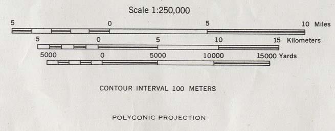
21 Latitude/Longitude Coordinates Lat/Long specifies the position of any location on the surface of Earth N or S Only E or W Only Los Angeles, Ca Lat: N Long: W Riverside, Ca Lat: N ' Long: W ' London, UK Lat: N ' Long: W ' Beijing, China Lat: N Long: E Sydney, Australia Lat: S Long: E Only Only How to say it: Los Angeles: North 34 degrees, minutes, West 118 degrees, minutes


22 Who Uses Latitude and Longitude? In the US Military, aviation and naval forces typically use latitude and longitude. Ships, boats, and airplanes travel at speeds called knots. 1 knot = 1 nautical mile per hour. 60 nautical miles = 1 degree of latitude. This makes it very easy to chart boat and airplane positions on sea charts and aviation charts.
23 Check on Learning (1/2) 1. What type of Map has contour lines on it? 2. Why are map projections always distorted in some way? 3. How big would a map have to be if it covered an area of 1 square mile and the scale of the map was 1:1?
24 Check on Learning (2/2) What s the latitude and longitude of Phoenix, AZ?
25 TOPOGRAPHIC MAPS Marginal Information, Colors, & Symbols A2. Identify the meaning of colors and symbols used on a topographic map, and what the marginal information conveys.

26 Topographic Map The feature that most distinguishes topographic maps from maps of other types is the use of contour lines to portray the shape and elevation of the land.

27 Marginal Information Around the margins of maps, there is a lot of information that helps you read and interpret the symbols on the map. This is called, for obvious reasons, marginal information.


28 Marginal Information Topographic Maps Sheet Name. Like a title, in the center of the top margin. Also in the lower left margin. Sheet Number. Listed with the Sheet Name. Used as a reference number for the map sheet. Adjoining Map Sheets Diagram. Shows the 8 map sheets adjacent to this sheet, with their sheet number (at the same map scale). Special Notes / Unit Imprint.


29 Marginal Information Topographic Maps Declination Diagram. Shows True, Grid, and Magnetic North, the G-M Angle, and how to convert grid to magnetic and magnetic to grid. Scales. Gives the scale used on the map. Graphically depicts distance in miles, meters, and yards. Contour Interval. Shows distance between contour lines

30 Marginal Information Topographic Maps Grid Reference Box. Tells you the 2-digit Grid Zone Designators, and where the boundaries are between grid zones on the map.
31 Marginal Information Topographic Maps Legend. Gives the effective date of the map data and defines the symbols used on the map.
32 Map Colors Black - on a map is the work of humans: buildings, railroads, bridges, boundaries, names Blue - always means water: lakes, ponds, rivers, streams, water well, marshes Brown - symbols are used for relief features - contour lines and elevation Green - indicates forest, woodlands, orchards, and other areas of heavy vegetation.
33 Map Colors Red - is used for larger, more important roads and surveying lines. Purple - is for overprinting: Revisions added from aerial photographs but not yet fieldchecked, or planned additions. White - is mostly clear of trees: fields, meadows, rocky slopes, and other open country.
34 Topographic Symbols
35 ROADS
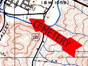
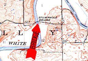
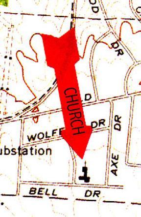
36 Building, Church, Mine Cemetery, Bridge
37
38
39 Check on Learning Can you guess each of the following symbols on a topographic map? You can figure most of them out by looking at the shape of the symbol, the color, and other identifying clues that are on the map.
40
41
42
43
44
45
46
47
48
49
50
51
52
53
54

55
56

57
58
59
60
61
62
63
64
65
66
67
68
69
70
71
72 23
73
74
75
76

77

78
79
80
81
82
83
84
85
86
87
88
89
90
91
92
93
94
95
96
97
98
99
100
101
102
103
104
105
106
107
108
109
110
111
112
113

114
115
116
117
118
119
120 Check on Learning 1. What color represents water features on a map? 2. What does the color brown symbolize on a map? 3. What does this symbol mean: 4. What does this symbol mean? 5. How do you determine the scale of a map?
121 ELEVATION & TERRAIN FEATURES CONTOUR LINES A3. Define contour lines. Identify the five major and three minor terrain features from contour line patterns. Determine the elevation of a point using contour lines.
122 CONTOUR LINES A way of graphically depicting elevation and the shape of the land Contours are lines that connect points of equal elevation on the earth s surface.
123 Relief The representation of the shapes of hills, valleys, streams and other features of the earth s surface Can be represented by colors for different elevations (called layer tinting), form (dashed) lines to show the basic shape of land, and shading (where the darker the color, the steeper the land) Most often, relief is shown by CONTOUR LINES
124 What are contour lines? Imaginary lines that represent the same elevation above or below sea level All points along a contour line are the same elevation
125 Contour Lines Contour lines are what makes a map the equivalent of 3D. They are lines that connect points of equal elevation on the earth s surface, and are used to illustrate topography, or relief, on a map. On American maps, they are usually in feet. Numerous contour lines that are close together indicate hilly or mountainous terrain; when far apart, they represent a gentler slope.
126 Three types of contour lines Index lines are the HEAVY or DARK colored contours, generally every fifth contour line; they show an elevation number. Four intermediate contour lines fall between the index contours and do NOT show their elevation. Supplementary contour lines are generally DASHED lines that show onehalf the contour interval. They are often used on maps where the contour interval is large, and the terrain somewhat featureless overall.

127 Contour Interval
128 Contour Interval The contour interval measurement, given in the map s marginal information, is the vertical distance between adjacent contour lines. The numbered Index contour lines, which are circled in red in the example on the right, give that particular line s elevation.
129 If every contour line was numbered on a map, it might look like this:
130 Determining an elevation Find the contour interval on the marginal map info Find the nearest INDEX contour and its elevation Determine if you are going lower or higher to the point you are concerned about Count up or down to determine the correct elevation
131 Determining an elevation What s the contour interval on this map? Even though we don t have the marginal information, you can tell by comparing the Index contour lines. You can see a 400 Index Contour, then a 600 Index Contour = 200 feet between Index Lines = 40 So the Contour Interval is 40 feet. Each contour line represents a point that s 40 feet higher than the contour line below it. Can you determine the elevation of the Water Tank?

132 Determining an elevation The Water Tank is on the second contour line up from the 400 Index, so it s 480 feet. How about the hilltop? The map actually gives you the hilltop s elevation: 882 feet!
133 Hilltops and Depressions For points at the top of hills, add half the contour interval. In this example, you would estimate the hilltop at 360 feet. For points at the bottom of depressions, subtract half the contour interval.

134 Benchmarks Sometimes, you will see a notation such as X BM 214 on a map. That means that map makers have measured that particular spot on the earth s surface to be exactly 214 feet above sea level
135 Terrain Features Terrain features are identified in the same manner on all maps, regardless of the contour interval, but you must realize that a hill in the Rocky Mountains will be much bigger than one in south Florida. You must be able to recognize all the terrain features to locate a point on the ground or to navigate from one point to another. The five major terrain features are: Hill, Ridge, Valley, Saddle, and Depression. The three minor terrain features are: Draw, Spur and Cliff.
136 Terrain features can be learned using the fist or hand to show what each would look like on the ground

137 Hill A point or small area of high ground. When you are on a hilltop, the ground slopes down in all directions.

138 Ridge A line of high ground with height variations along its crest. The ridge is not simply a line of hills; all points of the ridge crest are higher than the ground on both sides of the ridge.

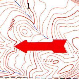
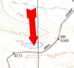
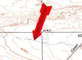
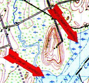
139 Valley Reasonably level ground bordered on the sides by higher ground. A valley may or may not contain a stream course. Contour lines indicating a valley are U-shaped and tend to parallel a stream before crossing it.

140 Saddle A dip or low point along the crest of a ridge. A saddle is not necessarily the lower ground between two hilltops; it may be a break along an otherwise level ridge crest.

141 Depression A low point or hole in the ground, surrounded on all sides by higher ground.

142 Draw Similar to a valley, except that it normally is a less developed stream course in which there is generally no level ground and, therefore, little or no maneuver room. The ground slopes upward on each side and toward the head of the draw.

143 Spur A usually short, continuously sloping line of higher ground, normally jutting out from the side of a ridge. A spur is often formed by two thoroughly parallel streams cutting draws down the side of a ridge

144 Cliff A vertical or near-vertical slope. A cliff may be shown on a map by contour lines being close together, touching, or by a ticked "carrying" contour line. The ticks always point toward lower ground.

145 Cut and Fill A feature where terrain has been cut away essentially a minor cliff, and where it has been filled in, creating more level ground than would normally be seen on the natural terrain feature. Often done to create a stable platform for a road or railroad.
146 Identify terrain features by SOSES Shape of the feature at its base Orientation of the object from your viewpoint Size of the feature Elevation of the feature Slope of the sides of the feature

147 Identify Terrain Features

148 Check on Learning
149 GRID COORDINATES A4. Determine a 4-, 6-, or 8-digit grid coordinate for a point on a topographic map with a protractor.
150 Grid Lines A series of straight lines intersecting at right angles forming squares Horizontal grid lines are numbered west to east Vertical grid lines are numbered south to north BASIC RULE Read right on the vertical lines, then up on the horizontal grid lines, or Read Right then Up
151 Grid Coordinates The map has vertical lines (top to bottom) and horizontal lines (left to right). These lines form small squares 1,000 meters on each side called grid squares. The lines that form grid squares are numbered along the outside edge of the map picture. No two grid squares have the same number.
152 Grid Lines m N m E
153 Grid Coordinate A grid square s coordinates are found by combining the identities of the horizontal and vertical grid lines that intersect at the lower left hand corner of the grid. The more digits you put in a grid coordinate, the more precise it is. A 4-digit grid coordinate gets you within 1000 meters of your point. A 6-digit grid coordinate gets you within 100 meters of your point. And an 8-digit grid coordinate gets you within 10 meters of your point.
154 Finding a 4-Digit Grid Coordinate GRID REFERENCE: m N m E
155 Your address is grid square How do you know this? Start from the left and read right until you come to 11, the first half of your address. Then read up to 81, the other half. Your address is somewhere in grid square 1181.
156 Grid square 1181 gives your general neighborhood, but there is a lot of ground inside that grid square. To make your address more accurate, just add another number to the first half and another number to the second half - so your address has six numbers instead of four.
157 To get those extra numbers, pretend that each grid square has ten lines inside it running north and south, and another 10 running east and west. This makes 100 smaller squares. You can estimate where these imaginary lines are.
158 Suppose you are halfway between grid line 11 and grid line 12. Then the next number is 5 and the first half of your address is 115. Now suppose you are also 3/10 of the way between grid line 81 and grid line 82. Then the second half of your address is 813. Your address is

159 Grid Coordinate Scale The most accurate way to determine the coordinates of a point on a map is to use a coordinate scale. You do not have to use imaginary lines; you can find the exact coordinates using a Coordinate Scale and Protractor.
160 Identifying a Grid Coordinate First, locate the grid square in which the point is located. The number of the vertical grid line on the left (west) side of the grid square is the first and second digits of the coordinates.
 side of the grid square is the fourth and fifth digits of the coordinates.")
161 Identifying a Grid Coordinate The number of the horizontal grid line on the bottom (south) side of the grid square is the fourth and fifth digits of the coordinates.
162 Identifying a Grid Coordinate To determine the third and sixth digits of the coordinates, place the coordinate scale on the bottom horizontal grid line of the grid square containing Point A, with the vertical scale going through the point.

163 Identifying a Grid Coordinate Line up the vertical line so it goes through your point, leaving the horizontal line along the horizontal grid line.

164 Identifying a Grid Coordinate On the bottom scale, the 100 meter mark nearest the vertical grid line provides the third digit, 5. On the vertical scale, the 100 meter mark nearest Point A provides the sixth digit, 3. Therefore the six-digit grid coordinate is
165 Grid Precision Grid squares are 1000 meters. They are subdivided into 100 meter and 10 meter marks The Grid Coordinate Scale helps you measure the grid square and determine a more accurate grid coordinate A 4-digit grid coordinate is accurate to 1000 meters A 6-digit grid coordinate is accurate to 100 meters An 8-digit grid coordinate is accurate to 10 meters

166 Grid Coordinate Scale and Protractor 1:50,000 Scale 1:25,000 or 1:250,000 Scale 1:100,000 Scale


167 Finding the Grid Coordinate of a Point Determine the scale of your map. Find the correct scale to use on your protractor. Determine the grid square the point is in. This gives 4 digits: 12xx56xx. Next, using the correct scale on your protractor, align the bottom right corner of the protractor scale to the bottom right corner of the grid square. Slide the protractor to the left until the line forming the right edge of the scale intersects the point. Read off the horizontal and vertical position:
168 Gives second two vertical coordinates: 55 Grid: Gives second two horizontal coordinates:
169 Grid Zone Designator A 2-letter designation that is unique to a 100,000 meter area. This is where the grid numbers start over again at 00. The Grid Reference Box in the Marginal Data shows the Grid Zones that are on that map. The correct depiction of a grid coordinate ALWAYS includes the Grid Zone. i.e. ET , which is 100,000 meters from FT
170 Check on Learning Determine the Grid Coordinate for the Given Point
171 Check on Learning If you have maps and protractors in your classroom, the instructor should give the students several points to determine 6- and 8- digit grid coordinates. The instructor should also give out several grid coordinates and have the students locate and identify the point on the map.
172 MEASURING DISTANCE A5. Measure distance on a topographical map using the map scale and a straight edge. Students should be able to measure distance of a straight line and of a curving road to within 50 meters.
173 Measure Distance You can use your map to measure the distance between two places. The maps are drawn to scale. This means that a certain distance on a map equals a certain distance on the earth. The scale is printed at the bottom and top of each map (i.e. Scale 1:50,000). This means that 1 inch on the map equals 50,000 inches on the ground. To change map distance to miles, meters, or yards, use the bar scales at the bottom of the map.
174 Measure Distance

175 Measure Distance Take a ruler or the edge of a paper and mark on it the straight line distance between your two points.

176 Measure Distance Then, put the ruler or the paper just under one of the bar scales and read the ground distance, in miles, meters, or yards. The bar scale here shows a ground distance of 1500 meters.
177 MEASURING ROAD = 3.2 Miles
178 Check on Learning 1. Select a road between two points on your map and determine the distance. 2. Select two points on your map and determine the distance in both meters and feet.
179 DETERMINING DIRECTION A6. Name the three types of north on a topographic map. Determine a magnetic azimuth to a point using a compass. Plot a grid azimuth on a topographic map.
180 DIRECTION ON A MAP and HOW TO USE A COMPASS

181 Direction a course along which someone or something moves is usually expressed in map reading as a degree or azimuth, or as a variant of North, South, East, and West. From any point on a plane, there are 360 degrees leading out from it in a circle. Directions
182 The Three Norths GRID NORTH MAGNETIC NORTH 0 True North is a line from any point on the earth s surface to the North Pole. All lines of longitude are true north lines. True North is usually symbolized in marginal information with a star. Magnetic North, as shown by the compass needle, points to the north magnetic pole, which is not the same as the geographic North Pole. It is shown in marginal information as a half-arrow. Grid North is the north that mapmakers put on a map, dependent of the map projection used. It is shown in the marginal information by the letters GN on a vertical line. G N TRUE NORTH


183 The Compass These are the two types of compass you ll see most often. Lensatic Compass Silva Compass
184 THE SILVA COMPASS
185 Finding North You see the red and black arrow? We call it the compass needle. On some compasses it might be red and white But, the red part of it is always pointing towards the earth's magnetic north pole.
. And you might have the letters N, S, W and E for North, South, West and East.")
186 Finding other Directions You've got a dial that turns on your compass. We call it the Compass housing (or bezel ring). On the edge of the compass housing, you will probably have a scale from 0 to 360. Those are the degrees or the azimuth (or you may also call it the bearing in some contexts). And you might have the letters N, S, W and E for North, South, West and East. If you want to go in a direction between two of these, you would combine them. If you would like to go in a direction just between North and West, you simply say: "I would like to go Northwest ".
187 Let's use Northwest as an example: Find out where on the compass housing northwest is. Turn the compass housing so that northwest on the housing comes exactly there where the large direction of travelarrow meets the housing. Hold the compass in your hand. And you'll have to hold it quite flat, so that the compass needle can turn. Then turn yourself, your hand, the entire compass, just make sure the compass housing doesn't turn, and turn it until the compass needle is aligned with the lines inside the compass housing.
188 Still working on finding NorthWest... Now, time to be careful!. It is extremely important that the red, north part of the compass needle points at north in the compass housing. If south points at north, you would walk off in the exact opposite direction of what you want! And it's a very common mistake among beginners. So always take a second look to make sure you did it right! A second problem might be local magnetic attractions. If you are carrying something of iron or something like that, it might disturb the arrow. Even a staple in your map might be a problem. Make sure there is nothing of the sort around.
189 Almost there! When you are sure you've got it right, walk off in the direction the direction of travel-arrow is pointing. To avoid getting off the course, make sure to look at the compass every hundred steps or so. Once you have the direction, aim on some point in the distance, and go there without staring down at the compass.
190 When do you need this technique? If you are out there without a map, and you don't know exactly where you are, but you know from your experience in the area that there is a road, trail, stream, river or something long and big you can't miss if you go in the right direction Then all you need to do is to turn the compass housing so that the direction you want to go in is where the direction of travel-arrow meets the housing. And follow the steps you were just shown. But why isn't this sufficient? First, it is not very accurate. You are going in the right direction, and you won't go around in circles, but you're very lucky if you hit a small spot this way. And, this requires you to have a mental image of the area you are in and what direction those landmarks might be in. That s why using the compass with a map is much, much better.
191 How to Shoot an Azimuth in 3 Easy Steps 1. Turn the dial of the compass to the given azimuth 2. Keep the compass flat in front of you with the Direction of Travel Arrow pointing straight ahead. 3. Turn your body so the red (north pointing) needle of the compass lines up inside the red housing on the base of the compass.
192 Let s try an example: Shoot an Azimuth of First, turn the dial to 150. Then be sure the compass is laying flat and the Direction of Travel Arrow is pointing straight ahead of you. Then turn your body so the red magnetic arrow is lined up within the red arrow on the compass casing.
193 Try these with your instructor: 10º 35º 125º 65º 320º 178º 143º 219º
194 Types of Azimuth There are three kinds of azimuth: Magnetic Azimuth: direction expressed as the angular difference between Magnetic North and the direction line (i.e. 140 ) Grid Azimuth: the angle measured between Grid North and a line plotted between two points on a map. Back Azimuth: the opposite direction of an azimuth. The back azimuth is 180 from an azimuth. For azimuths more than 180, subtract 180. For azimuths less than 180, add 180. A back azimuth of 180 is either 0 or 360.
195 Using a Protractor There are several types of protractors circular, half-circle, square, and rectangular. All have a scale around the outer edge and an index mark in the middle. On military protractors, you read the inner of the two scales because it is broken into degrees from 0 to 360. Each tick mark on the degree scale represents one degree.
196 Using a Protractor Coordinate Scale and Protractor (Commonly called a Protractor) Coordinate Scale for measuring grid coordinates Index where the N/S and E/W lines cross in the middle. It s the central point from which you measure an azimuth. 360 Degrees - usually the inner of two types of direction marks Mils the outer measuring marks found on Army protractors. Used in field artillery plotting. You can ignore them (or even carefully cut them off your protractor!)
197 PNT 2 Find the two points you want to measure an azimuth between. PNT 1
198 PNT 2 Line up your protractor so the index lines are exactly parallel to the map s grid lines PNT 1
199 PNT 2 Align a straight edge along both points. Check carefully to see where it crosses the protractor s degree scale. 39! PNT 1
200 If you have maps and protractors in your classroom, practice plotting some azimuths between points on your map!
201 Check on Learning 1. What are the three types of north? 2. How many degrees are there on a protractor? 3. Do you need the outer scale on a military protractor?
202 DETERMINING POLAR COORDINATES A7. Given a known point, a distance and direction, determine an unknown point on a topographic map.
203 Polar Coordinates A method of locating or plotting an unknown position from a known point by giving a direction and a distance along that direction line is called polar coordinates. The following elements must be present when using polar coordinates. Current known location on the map Azimuth (grid or magnetic) Distance (in meters) This is a common task on a land nav course!
204 PNT 1 STEP 1. PLACE THE INDEX MARK OF THE PROTRACTOR AT THE CENTER OF MASS ON THE POINT FROM WHICH YOU ARE MEASURING.
205 56 STEP 2. LOCATE THE DESIRED AZIMUTH ON THE PROTRACTOR SCALE AND PLACE A DOT ON THE MAP AT THIS AZIMUTH. PNT 1 EXAMPLE: 56 DEGREES Hint: It s a lot easier to use your protractor if you trim the outside edge. We don t use the mils, and it s easier to work with the degrees without the mils being there.
206 STEP 3. REMOVE THE PROTRACTOR AND CONNECT THE POINT AND DOT WITH A STRAIGHT LINE. PNT 1
207 STEP 3. REMOVE THE PROTRACTOR AND CONNECT THE POINT AND DOT WITH A STRAIGHT LINE. PNT 1 STEP 3. REMOVE THE PROTRACTOR AND CONNECT THE POINT AND DOT WITH A STRAIGHT LINE.
208 STEP 4. SELECT THE APPROPRIATE SCALE MEASUREMENT AND PLACE A PAPER STRAIGHT EDGE ON THE SCALE. EXAMPLE: DISTANCE IN METERS
209 STEP 5. DETERMINE THE DESIRED DISTANCE TO MEASURE FROM THE SCALE AND MARK THE PAPER AT THIS DISTANCE USING TICK MARKS. EXAMPLE: 3400 METERS
210 PNT 1 PNT 1 STEP 6. ALIGN THE STRAIGHT EDGE WITH THE AZIMUTH LINE. ENSURE THE FIRST TICK MARK IS CENTER OF MASS ON THE KNOWN POINT.
211 PNT 1 PNT 1 STEP 7. PLACE A DOT ON THE MAP AT THE SECOND TICK MAR FROM THE STRAIGHT EDGE ON THE MAP. THE POSITI OF THE SECOND TICK MARK IS THE POSITION OF THE UNKNOWN POINT.
212 REMOVE THE STRAIGHT EDGE AND DETERMINE THE GRID COORDINATE TO THE SECOND POINT. EG PNT 1 STEP 8. REMOVE THE STRAIGHT EDGE AND DETERMINE THE GRID COORDINATE TO THE SECOND POINT.
213 Check on Learning Put the following steps in order: Connect the point and dot with a straight line Place the protractor s index mark on a known point Plot the distance from the scale on your direction line Mark the distance on a straight edge from the map scale Determine the grid coordinate of your unknown point Locate the desired azimuth and mark the map
214 THE G-M ANGLE DECLINATION DIAGRAM A8. Use a Declination Diagram to convert a grid azimuth to a magnetic azimuth and vice versa.
215 Declination Diagram If you re going to use a map and compass together, you must know how to make the information compatible The map shows Grid North The compass shows Magnetic North The Declination Diagram on the marginal information shows the relationship between the three norths, and how to determine the G-M Angle
216 Declination Diagram Shows the 3 norths Tells you the G-M Angle (21 in this case) Tells you how to convert: East G-M Angle: Magnetic to Grid ADD Grid to Magnetic SUBTRACT West G-M Angle: Magnetic to Grid SUBTRACT Grid to Magnetic ADD This example is an EAST G-M Angle (the Magnetic North is east of Grid North)
217 Why You Need It Why does every map need a declination diagram? Because different parts of the globe have different declinations (and they also change over time). For example, the declination varies from 16 degrees west in Maine, to 6 in Florida, to 0 degrees in Louisiana, to 4 degrees east in Texas. Without knowing the G-M Angle, you can t really use a map and compass together If MN is West of GN, you subtract when going from magnetic to grid If MN is East of GN, you add when going from magnetic to grid And going from grid to magnetic you do the opposite! It s very handy to have this spelled out on your map!
218 Declination Diagrams
219 Check on Learning 1. You shoot a magnetic azimuth of 215. Your G-M Angle is 21 East. Convert your magnetic azimuth to a grid azimuth.
220 Answer Magnet to Grid Add in the East = 236
221 Check on Learning 2. You have a grid azimuth of 95. Your G- M Angle is 5 West. Convert your grid azimuth to a magnetic azimuth.
222 Answer Grid to Magnetic Add in the West = 100
223 Check on Learning 3. You have a grid azimuth of 5. Your G-M Angle is 21 East. Convert your grid azimuth to a magnetic azimuth.
224 Answer Grid to Magnetic Subtract in the East 5 is the same as = 344
225 Summary A1. Introduction to Maps A2. Topographical Map Basics A3. Elevation and Terrain Features A4. Grid Coordinates A5. Measuring Distance A6. Direction A7. Polar Coordinates A8. G-M Angle: Declination Diagram
Using Map and Compass Together
 Using Map and Compass Together In situations where you foresee a potential evacuation on foot, where there are no roads, and no indication as to the direction of travel (i.e., road signs), it is recommended
Compass Basics. Quick Map Basics Review For Compass Use
 Compass Basics Quick Map Basics Review For Compass Use A topographic map tells you where things are and how to get to them, whether you're hiking, biking, hunting, fishing, or just interested in the world
Navigating with Map & Compass. Nevada County Sheriff s Search & Rescue
 Navigating with Map & Compass Nevada County Sheriff s Search & Rescue Objectives Very Practical Teach you how to go from point A to point B Go from the wilderness (real world) to a map and visa versa Agenda
Chapter 3 Models of the Earth. 3.1 Finding Locations on the Earth. 3.1 Objectives
 Chapter 3 Models of the Earth 3.1 Finding Locations on the Earth 3.1 Objectives Explain latitude and longitude. How can latitude and longitude be used to find locations on Earth? How can a magnetic compass
Topographic Map Series:
 DEFINITION OF A MAP A MAP IS A GEOGRAPHIC PREPRESENTATION OF A PORTION OF THE EARTH S SURFACE DRAWN TO SCALE, AS SEEN FROM ABOVE. IT S USES COLORS, SYMBOLS AND LABELS TO REPRESENT FEATURES FOUND ON THE
B. Topographic maps are also called. contour maps
 Topographic Maps Introduction A. Topographic maps are essential tools in geologic and engineering studies because they show the configuration of Earth's surface in remarkable detail and permit one to measure
Map Reading & Compass Use
 Spring 2013 Kestrel Land Trust Page 2 / 10 Contents Map Basics... 3 Map Types... 3 Terrain Association... 4 Estimating Distance: Pacing... 4 Contour Lines... 5 Navigating with a Compass... 6 Compass Types...
Orienteering Maps & Map Reading Latitude and Longitude Scale
 Orienteering Maps & Map Reading A map is a two-dimensional representation of the three-dimensional world you'll be hiking in. All maps will have some basic features in common and map reading is all about
King County Explorer Search and Rescue. Course B Map & Compass
 King County Explorer Search and Rescue Course B Map & Compass Disclaimer The intent of this presentation is to provide a basic overview of maps, compasses, and location finding. It is not meant to be a
BUSH NAV BUSH NAV DAY Navigation for Bush Navigation Day. November. WhitehorseD AY. Section 1 Registration, Maps & Checkpoints
 BUSH DAY Navigation for Bush Navigation Day Robert Kirwan, Nunawading SES W NW N NE E If you have little or no bush navigation experience then you will have been teamed up with members that have that experience
APPENDIX A GLOSSARY. Appendix A.1
 APPENDIX A GLOSSARY Appendix A.1 Appendix A.2 Back Bearing A back bearing is measured from the object to your position. It is the exact opposite of a direct bearing. Base Line An imaginary line on the
Topographic Maps and Landforms Geology Lab
 Topographic Maps and Landforms Geology Lab Ray Rector: Instructor Today s Lab Activities 1) Discussion of Last Week s Lab 2) Lecture on Topo Maps and Elevation Contours 3) Construct Topographic Maps and
USING THE MILITARY LENSATIC COMPASS
 USING THE MILITARY LENSATIC COMPASS WARNING This presentation is intended as a quick summary, and not a comprehensive resource. If you want to learn Land Navigation in detail, either buy a book; or get
Chapter 3 SECTION 1 OBJECTIVES
 Chapter 3 SECTION 1 OBJECTIVES Distinguish between latitude and longitude and locate coordinates on maps. Explain how latitude and longitude can be used to locate places on Earth s surface. Explain the
LAND NAVIGATION 2-1. DEFINITION
 LAND NAVIGATION MAPS Cartography is the art and science of expressing the known physical features of the earth graphically by maps and charts. No one knows who drew, molded, laced together, or scratched
What is a map? A Map is a two or three-dimensional model or representation of the Earth s surface. 2-Dimensional map
 What is a map? A Map is a two or three-dimensional model or representation of the Earth s surface. 2-Dimensional map What is a Map Projection? Planar Projection Projection A Projection is a mathematical
AS 410 Land Navigation. Chpt 4-1
 AS 410 Land Navigation Chpt 4-1 Overview Types of Maps Map Legends / Scales Latitude and Longitude Orienteering Why? Why important to learn how to read a compass and map? No cell phone coverage Mountain
Earth Science Regents Reading Topographic Maps
 Earth Science Regents Reading Topographic Maps Name Period Quick Tutorial on Degrees, Minutes, and Seconds of Latitude and Longitude A degree of latitude on the surface of the earth is about 70 miles long.
USING THE MILITARY LENSATIC COMPASS
 USING THE MILITARY LENSATIC COMPASS WARNING This presentation is intended as a quick summary, and not a comprehensive resource. If you want to learn Land Navigation in detail, either buy a book; or get
LESSON 2: INTRODUCTION TO TOPOGRAPHICAL MAPS
 LESSON 2: INTRODUCTION TO TOPOGRAPHICAL MAPS Finding your way if you become separated from a group. PURPOSE This lesson presents an overview of topographic maps. It describes their characteristics and
The Tacoma Mountaineers Wilderness Navigation
 The Tacoma Mountaineers Wilderness Navigation Navigation Fundamentals Navigation in mountainous terrain and wilderness areas requires a set of skills, of which using a map and compass is only one part.
HWA CHONG INSTITUTION NATIONAL POLICE CADET CORPS TOPOGRAPHY AND ORIENTEERING. Topography and Orienteering
 Topography and Orienteering 1. Introduction Orienteering is about using a topographic map and compass to find points in the landscape. It is fun and challenging, as one would need to take reference to
Topographic Maps. Take Notes as you view the slides
 Topographic Maps Take Notes as you view the slides Lesson Objectives Define a topographic map and state its uses. Describe how contour lines show the elevations, shape, and slope of the land. Identify
What is a map? Understanding your map needs
 What is a map? A map is simply a drawing or picture of a landscape or location. Maps usually show the landscape as it would be seen from above, looking directly down. As well as showing the landscape of
What Is a Globe? Hemispheres. Main Idea Globes and maps provide different ways of showing features of the earth. Terms to Know
 r Main Idea Globes and maps provide different ways of showing features of the earth. Terms to Know hemisphere latitude longitude scale bar scale relief elevation contour line What Is a Globe? A globe is
Mapping Earth. How are Earth s surface features measured and modeled?
 Name Mapping Earth How are Earth s surface features measured and modeled? Before You Read Before you read the chapter, think about what you know about maps Record your thoughts in the first column Pair
Navigating for Scouts A Self-teaching Guide to Navigation with Map and Compass
 Don Burgess, November 2003 Materials topographic maps Navigating for Scouts A Self-teaching Guide to Navigation with Map and Compass metric ruler orienteering compass 30 M/5 Hamilton-Burlington 41 I/13
56H. This system allows definition of points on the Earth s surface to within 100 meters. Page 20. Navigation Systems Basics of Maps
 Grid References Many maps are provided with the standard grid overlaying them. This provides a simple and accurate method for finding features on the map. It is a network of intersecting parallel lines
Map Skills Unit. Note taking unit
 Map Skills Unit Note taking unit Introduction To learn about the Earth, we are going to learn about two geographic tools you can use.globes and maps. Globe A globe is a round model of the planet Earth
Basic Map Skills for the Outdoors
 Geography 80-20 80% of what there is to know, for 20% of the sweat Basic Map Skills for the Outdoors Map Scale Map source: US Geological Survey Four ways to indicate map scale: Representative fraction
Map Reading: Grades 4 & 5
 Map Reading: Grades 4 & 5 Grades: 4,5 Team Size: 1-2 competitors Duration: 25 minutes Supervisors: Sriram Garapati, Rebecca Neill-Totsuka Summary Description Students will solve a mystery using different
Date: UNI. world. *Dedicated to
 Name: Date: UNI IT THREE 2D and 3D model s of the natural world *Dedicated to Name: Date: ABSTRACT T AND RATIONALE A topographic map is a type of map that depicts the detail and quantitative representation
Introduction to Cartography Part I
 Introduction to Cartography Part I Introduction to Cartography Maps vs. Globes General Types of Maps Standard Map Features Maps versus Globes Map: a representation of the world, or part of it, in two dimensions
Butte County Fire Department
 Butte County Fire Department Basic Land Navigation Verification Sheet I verify that Print Supervisor s name has completed the Print Employee s name Basic Land Navigation self study guide on. Date Attached
Latitude and Longitude
 U n i t 3 M a p p i n g P a g e 1 Latitude and Longitude Note: These coordinates are always expressed LATITUDE/LONGITUDE!!! Coordinate System: Using and to find your position on Earth. LATITUDE LATITUDE
Activities: Map and Compass
 Activities: Map and Compass Determining General Directions Modified with permission from Outdoor Living Skills Series: Map and Compass, Missouri Department of Conservation Overview: Students use the sun
Lab Topographic Maps. Name: Partner: Purpose. Background Information
 Lab Topographic Maps Name: Partner: Purpose The purpose of this lab is to familiarize you with graphic representations of the Earth s surface primarily maps. Simple line maps show the spatial relationship
Practice Packet Topic 2: Measuring Earth
 Practice Packet Topic 2: Measuring Earth Vocabulary: Lesson 1: Lesson 2: Name: Lesson 3: Mini Lesson: Latitude Longitude Pre-Test 1. To locate exact places on the earth, one must look at a. The intersecting
2 Mapping Earth Reading Essentials. 2. Contrast What is the difference between a map view and a profile view?
 Mapping Earth Maps What do you think? Read the three statements below and decide whether you agree or disagree with them. Place an A in the Before column if you agree with the statement or a D if you disagree.
Geology 101 Lab Worksheet: Topographic Maps
 Geology 101 Lab Worksheet: Topographic Maps Name: Refer to the Topographic Maps Lab for the information you need to complete this worksheet (http://commons.wvc.edu/rdawes/g101ocl/labs/topomapslab.html).
USING THE MILITARY LENSATIC COMPASS
 USING THE MILITARY LENSATIC COMPASS WARNING This presentation is intended as a quick summary, and not a comprehensive resource. If you want to learn Land Navigation in detail, either buy a book; or get
Advanced Vectors. Table of Contents
 Advanced Vectors Table of Contents I. Location and Distance on Earth 2 Introduction Determining Latitude Latitude and the North Star Determining Longitude Longitude and Time Using Earth's Grid System Google
Understanding Projections
 GEOGRAPHY SKILLS 1 Understanding Projections The earth is a sphere and is best shown as a globe. For books and posters, though, the earth has to be represented as a flat object. To do this, mapmakers create
Laboratory Exercise #2 Introduction to Quadrangle Maps
 page - 1 Laboratory Exercise #2 Introduction to Quadrangle Maps A. Introduction to Quadrangle Maps The United States Geological Survey has developed a nationwide series of quadrangle maps that cover small
MILITARY TOPOGRAPHIC MAP II B170247XQ STUDENT HANDOUT
 UNITED STATES MARINE CORPS THE BASIC SCHOOL MARINE CORPS TRAINING COMMAND CAMP BARRETT, VIRGINIA 22134-5019 MILITARY TOPOGRAPHIC MAP II B170247XQ STUDENT HANDOUT Basic Officer Course Introduction Importance
UNIT 1C. USING TOPOGRAPHIC MAPS WHERE IN THE WORLD... ARE YOU?
 UNIT 1C. USING TOPOGRAPHIC MAPS WHERE IN THE WORLD... ARE YOU? TIME 60-90 minutes LEVEL All BENCHMARKS Next Generation Science Standards MS-LS1.D Science & Engineering Practices Developing and Using Models
FIND PLACES ON GLOBES USING LATITUDE
 GLOBES, MAPS & GRAPHS FIND PLACES ON GLOBES USING LATITUDE AND LONGITUDE LINES FIND PLACES ON MAPS USING A GRID SYSTEM NAME SEVERAL TYPES OF MAP PROJECTIONS AND EXPLAIN THEIR BENEFITS AND SHORTCOMINGS
Name Class Date. For each pair of terms, explain how the meanings of the terms differ.
 Skills Worksheet Chapter Review USING KEY TERMS For each pair of terms, explain how the meanings of the terms differ. 1. true north and magnetic north 2. latitude and longitude 3. equator and prime meridian
EARTH SCIENCE KEY UNIT 2-H
 EARTH SCIENCE KEY UNIT 2-H UNIT 2 MODELS & DIMENSIONS OF EARTH I. Model = ANYTHING THAT REPRESENTS THE PROPERTIES OF AN OBJECT OR SYSTEM A. Types and examples of models: 1. PHYSICAL Provides us with information
Laboratory Exercise #2 Introduction to Quadrangle Maps
 page - Laboratory Exercise #2 Introduction to Quadrangle Maps A. Introduction to Quadrangle Maps The United States Geological Survey has developed a nationwide series of quadrangle maps that cover small
Introduction to Geography
 Introduction to Geography ropic of Cancer 3½ N Arctic Circle 90 N Prime Meridian 0 Arctic Ocean Mississippi R. Appalachian Mts. Europe Rocky Mountains N. America Atlantic Gulf of Ocean Mexico Caribbean
Topographic Maps. More than a Road Map
 Topographic Maps More than a Road Map What is a Topographic Map? Scaled representation of features on the surface of the Earth such as roads, rivers, and plains Provides information about land elevations
In order to be adequately prepared for a test on this topic you should be able to:-
 Topic 2: MAPPING In order to be adequately prepared for a test on this topic you should be able to:- 1. Find and also provide both FOUR and SIX figure Area and Grid References 2. Calculate distances both
REVISION: MAPWORK 18 SEPTEMBER 2014
 REVISION: MAPWORK 18 SEPTEMBER 2014 Lesson Description In this lesson we revise: Various mapwork calculations Summary Relative Position Bearing is the angular (angle) distance between two points True Bearing
Chapter 1 Overview of Maps
 Chapter 1 Overview of Maps In this chapter you will learn about: Key points when working with maps General types of maps Incident specific maps Map legend and symbols Map sources A map is a navigational
Map Skills and Geographic Tools
 Name: Period: Map Skills and Geographic Tools TEKS: 8.9C interpret topographic maps and satellite views to identify land and erosional features and predict how these features may be reshaped by weathering
AP Human Geography Chapter 1: Thinking Geographically Key Issue 1: How do Geographers describe where things are?
 AP Human Geography Chapter 1: Thinking Geographically Key Issue 1: How do Geographers describe where things are? Studying Human Geography Physical Geography Physical geography deals with Earth s natural
ORIENTEERING I.E.S. JUANA DE CASTILLA ORIENTEERING. 3rd E.S.O. SECOND TERM P.E. DEPARTMENT
 3rd E.S.O. SECOND TERM 1 Orientation is the set of systems that allows us to recognize at all times: The situation of the cardinal points The place where we are The direction to take to reach the desired
Relative and Absolute Directions
 Relative and Absolute Directions Purpose Learning about latitude and longitude Developing math skills Overview Students begin by asking the simple question: Where Am I? Then they learn about the magnetic
Map reading notes. It is a very useful kind of map that shows the topography of an area, i.e whether it is flat, undulating, rugged or mountainous
 Introduction Map reading notes In the course of 2 or 3 years course, Candidates will be exposed to topographical maps from tropical countries such as Mauritius, Tanzania, Zimbabwe and Jamaica. Many of
Cartography the art of making maps
 Cartography the art of making maps A map is a drawing or a picture of the earths surface, showing how things are related to each other by distance, direction and size. Maps are used for: Navigation Distance
OA Guide to Map & Compass. The Backpacker's Field Manual by Rick Curtis
 OA Guide to Map & Compass part of The Backpacker's Field Manual by Rick Curtis Published by Random House 1998 This material is taken from Chapter 6 - Wilderness Travel from The Backpackers Field Manual
Maps: Geography s Basic Tools
 Maps: Geography s Basic Tools What is a map? - A map is a representation of the earth s features drawn on a flat surface. - Maps use points, lines, colours, and symbols to represent the features of an
Geographic Grid. Locations Feature 1 Feature 2 Feature 3
 Geographic Grid Name The geographic grid refers to the internationally-recognized system of latitude and longitude used to location positions on Earth's surface. Accurate use of this coordinate system
Elementary Social Studies Content Area Assessment Task. Winter 2010 EDUC 203
 1 Elementary Social Studies Content Area Assessment Task Winter 2010 EDUC 203 Students: Fourth grade class in Watsonville, CA. Approximately 90% Latino, primarily of Mexicandescent. About 80% participate
Geography and Earth Science. Unit 5
 Geography and Earth Science Unit 5 Chapter 1 Map Skills Lesson 2 Introduction to Maps Key Terms What You Will Learn to Do Use map reading skills bar scale contrast elevation intermittent landforms legend
How to Use a Compass
 How to Use a Compass The compass consists of a magnetized metal needle that floats on a pivot point. The needle orients to the magnetic field lines of the earth. The basic orienteering compass is composed
ORIENTEERING. The challenge is to use the map to decide the best route to complete the course in the quickest time. Orienteering Map. Compass.
 ORIENTEERING Orienteering is similar to a cross-country race but you navigate using a map instead of following a set course. It is an outdoor sport where competitors navigate their own way, you can run,
Charts and Chart Work with Poole Sailing
 with Poole Sailing Nautical charts are a mine of information but they need to be up to date. Corrections to charts are published by the Hydrographic Office monthly as Notices to Mariners both in print
 Chapter 2 Mapping Our World Picture: Mount Capulin, Raton, NM Cinder Cone Volcano ://3.bp.blogspot.com/_sKz1KwXRzcg/SzFzM52gIoI/AAAAAAAAABk/hguBAT80pk0/s320/capulin.jpg http://www.peteandmelissa.com/images/oklahoma/p1020190.jpg
Background Information
 Oceanography LAB #1: Marine Charts and Navigation Background Information Latitude and Longitude A coordinate is an address a means of designating location. Most coordinate systems involve a network of
Butte County Fire Department
 Butte County Fire Department Basic Land Navigation Verification Sheet I verify that Print Supervisor's name Print Employee's name has completed the Basic Land Navigation self study guide on Date Attached
From Science Olympiad Student Center
 1 of 10 3/5/13 8:18 AM Forums Wiki Test Exchange Image Gallery Score Tracker Road Scholar From Science Olympiad Student Center In Road Scholar, Forum Threads Tests There are no images available for this
Map Reading: Grades 2 & 3
 Map Reading: Grades 2 & 3 Grades: 2, 3 Team Size: 1-2 competitors Duration: 25 minutes (5 minute introduction, 20 minutes for questions) Supervisors: Rebecca Neill-Totsuka, Sriram Garapati Summary Description
About places and/or important events Landmarks Maps How the land is, hills or flat or mountain range Connected to maps World Different countries
 What do you think you know about geography? About places and/or important events Landmarks Maps How the land is, hills or flat or mountain range Connected to maps World Different countries What do you
2. What does the map scale tell the map reader? a ratio between the actual distance on the ground and the length given to that distance on a map
 AP Human Geography - Damon Name Unit 1 - Intro to Human Geography Hour Map and Globe Skills Review Note: All links in this packet are found on our Wikispace under Map and Globe Skills Review First, read
Test Bank Chapter 2: Representations of Earth
 Multiple Choice Test Bank Chapter 2: Representations of Earth 1. A rhumb line on a Mercator projection is a line of. a. true size b. true shape c. true compass bearing d. true location 2. Maximum longitude
MODULE SEVEN - NAVIGATION MATERIALS
 1 MODULE SEVEN - NAVIGATION MATERIALS CONTENTS Explain the map and how to interpret Marginal Information 2-3 (IO 2I10) [Navigation Pam - paras 117-123] Calculate and plot 4 and 6 figure Grid References
Topographic Maps Self-Instruction Lab (2016 edition) Geology 100 David Harbor s Section. 12 inches x 1 mile
 Geology 100 David Harbor s Section. 12 inches x 1 mile") Topographic Maps Name Self-Instruction Lab (2016 edition) Geology 100 David Harbor s Section Topographic maps are an important aid for a geologist, but maps are also useful for hikers, bicyclists, and
Topographic Maps Name Self-Instruction Lab (2016 edition) Geology 100 David Harbor s Section Topographic maps are an important aid for a geologist, but maps are also useful for hikers, bicyclists, and
Red Star Navigation. Bearings:
 Red Star Navigation Bearings: The main focus in Red Star Navigation is how to use a compass and in particular compass bearings. It is important for cadets to describe bearings as this will assist them
THE EARTH AND ITS REPRESENTATION
 UNIT 7 THE EARTH AND ITS REPRESENTATION TABLE OF CONTENTS 1 THE EARTH AND THE SOLAR SYSTEM... 2 2 THE EARTH S MOVEMENTS... 2 2.1 Rotation.... 2 2.2 The revolution of the Earth: seasons of the year....
Geography Can Be Cool. Seriously
 Geography Can Be Cool Seriously Why does geography matter? Geography: the study of looking at every aspect of the Earth s systems, such as human economies, societies, cultures, plants, animals, & climate.
STAAR Science Tutorial 40 TEK 8.9C: Topographic Maps & Erosional Landforms
 Name: Teacher: Pd. Date: STAAR Science Tutorial 40 TEK 8.9C: Topographic Maps & Erosional Landforms TEK 8.9C: Interpret topographic maps and satellite views to identify land and erosional features and
Map reading made easy
 Map reading made easy 1. What is a map? A map is simply a drawing or picture (in 2-D) of a landscape or area of a country (in 3-D). It could be anything from a sketch map for a visitor to find your school
Notes and Summary pages:
 Topographic Mapping 8.9C Interpret topographical maps and satellite views to identify land and erosional features and predict how these shapes may be reshaped by weathering ATL Skills: Communication taking
MAPS AND THEIR CLASSIFICATION
 MAPPING MAPS AND THEIR CLASSIFICATION WHAT IS A MAP? A map is representation of the Earth's surface, showing how things are related to each other by distance, direction, and size. Maps are a way of showing
1. The topographic map below shows a depression contour line on Earth's surface.
 1. The topographic map below shows a depression contour line on Earth's surface. Points A, B, C, and D represent surface locations. Contour line elevations are in feet. Which profile best shows the topography
Map Skills Lesson 1. Materials: maps, pencils, Lesson 1 Worksheet, strips of paper, grid paper
 Map Skills Lesson 1 Use cardinal directions, map grids, scales, and titles to locate places on a map. Interpret a map using information from its title, compass rose, scale, and legend. Vocabulary: map,
Basic Land Navigation. Clark County Sheriff Core Comp Rev. # Land Navigation
 Basic Land Navigation Clark County Sheriff Core Comp Rev. # 2018 1 Land Navigation Requirement Through written evaluation the applicant will demonstrate knowledge of land navigation involved in Search
PROJECTIONS AND COORDINATES EXPLORED THROUGH GOOGLE EARTH EXERCISE (SOLUTION SHEET)
") PROJECTIONS AND COORDINATES EXPLORED THROUGH GOOGLE EARTH EXERCISE (SOLUTION SHEET) Name: Date: Period: Note: Correct answers on some problems are indicated with a yellow highlight. PROJECTIONS 1. Here
PROJECTIONS AND COORDINATES EXPLORED THROUGH GOOGLE EARTH EXERCISE (SOLUTION SHEET) Name: Date: Period: Note: Correct answers on some problems are indicated with a yellow highlight. PROJECTIONS 1. Here
Chapter 02 Maps. Multiple Choice Questions
 Chapter 02 Maps Multiple Choice Questions 1. Every projection has some degree of distortion because A. a curved surface cannot be represented on a flat surface without distortion. B. parallels and meridians
NAVIGATION. 2. Marginal Information
 NAVIGATION 1. The Map Definition and Handling A map is a graphic representation, usually on a plane surface and at an established scale, of natural or artificial features on the surface of a part or a
Latitude and Longitude, Plus Map Scale
 Name Lab 4 More Date: Latitude and Longitude, Plus Map Scale In the first few labs of the semester, you found that you needed to look at a variety of maps to answer all the questions. One reason you needed
Geographer s Toolkit. Geography of Canada
 Geographer s Toolkit Geography of Canada www.craigmarlatt.com/school Geographer s Toolkit 1. Parts of a Map Map Symbols Mapping Your Location 2. Types of Maps 3. Political Map of Canada 4. Drainage Map
Parts of a Map. Map Skills. The Title. There are 4 main parts of a map: The Title The Compass Rose The Map Key The Scale
 Map Skills Parts of a Map There are 4 main parts of a map: The Title The Compass Rose The Map Key The Scale The Title The title of the map is usually at the top and describes the topic of the map Example:
Class Notes: Mapping the Earth
 Name: Date: Period: Mapping the Earth The Physical Setting: Earth Science Class Notes: Mapping the Earth I. Latitude and Longitude Map -! Latitude -! Also called These lines intersect Equator -! The North
Maps. 3. Which altitude of Polaris could be observed in New York State?
 Name: Date: 1. For an observer in New York State, the altitude of Polaris is 43 above the northern horizon. This observer s latitude is closest to the latitude of A. New York City B. Utica 3. Which altitude
Maps and Globes. By Kennedy s Korner
 Maps and Globes By Kennedy s Korner Map Key or Symbols Maps use symbols to show places and things on Earth. Symbols are drawings that stand for something real. A map key tells you what each symbol stands
Chapter 1 Test on Geography Skills
 Name Score Chapter 1 Test on Geography Skills Part 1 Matching (14 pts.) Match each term in Column B with its correct definition in Column A by clearly writing the number in the blank space provided. Two
Map reading made easy
 Map reading made easy Maps can be great fun and they can lead you to all sorts of discoveries. They can help you get to know an area really well, because they pinpoint interesting places that are often