Maps: Geography s Basic Tools
|
|
|
- Wilfrid Boyd
- 6 years ago
- Views:
Transcription
1 Maps: Geography s Basic Tools
2 What is a map? - A map is a representation of the earth s features drawn on a flat surface. - Maps use points, lines, colours, and symbols to represent the features of an area. - v=x4wgfshzxbg
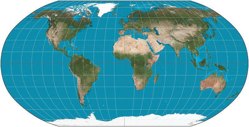
3 Map Projections - Used to portray all or part of the round Earth on a flat surface - It cannot be done without some distortion. - Every projection has its own set of advantages and disadvantages. There is no best projection. - The mapmaker must select the one best suited to the needs, reducing distortion of the most important features. - Every flat map misrepresents the surface of the Earth in some way. No map can rival a globe; however, a map or parts of a map can show one or more - but never all- of the following: true directions, true distances, true areas, true shapes.
4 Distortions can include: - Direction Distance Area Shape Some maps need to sacrifice some accuracy to achieve its goal.
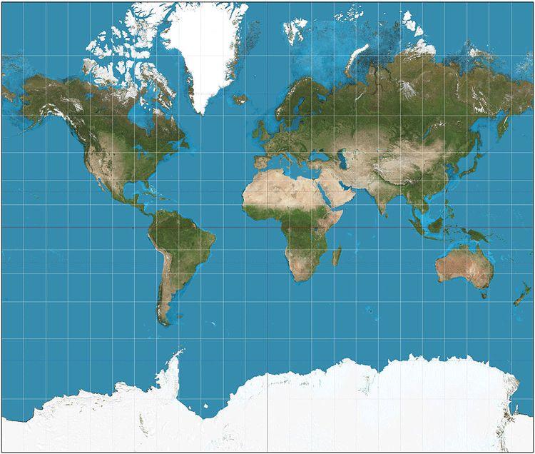
 - significant distortion occurs at the higher latitudes, where the parallels become further apart, and the poles cannot be shown Mercator maps are used for naval navigation")
5 Cylindrical Projection - Projection in which meridians are mapped to equally spaced vertical lines and circles of latitude (parallels) are mapped to horizontal lines - Ex. Mercator Projection (1569) - significant distortion occurs at the higher latitudes, where the parallels become further apart, and the poles cannot be shown Mercator maps are used for naval navigation and calculating distances, but, unsuitable for general use as it makes some elements appear larger than they actually are.
6
, are represented by concentric circular arcs, and the meridians (lines of longitude), by straight, equally spaced, radiating lines. - Ex.")
7 Conical Projection - We can visualize the Earth projected onto a cone, which is cut lengthwise and laid flat. - The parallels (lines of latitude), are represented by concentric circular arcs, and the meridians (lines of longitude), by straight, equally spaced, radiating lines. - Ex. Lambert Conformal Conic (for aeronautical directions) Conical Projections are also used as regional maps for mid-latitude nations/landforms. Most common map used at Statistics Canada to show their information

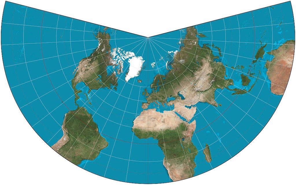
8 Lambert Conformal Conic
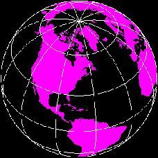
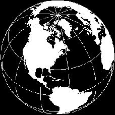
9 Planar and Azimuthal Projection (Part 1) - A portion of the Earth s surface is transformed from a perspective point to a flat surface. - In the polar case, the parallels are represented by a system of concentric circles sharing a common point of origin from which radiate the meridians, spaced at true angles. - This projection shows true direction only between the centre point and other locations on the map.
10 Planar and Azimuthal Projection (Part 2) - Any straight line drawn from the centre point on the map is on a great circle. The expression, great circle route, is the shortest path between two points the Earth. - This information is most useful in air navigation, because aircraft usually travel along great circle routes. - Example: Gnomonic (used for aeronautical navigation)

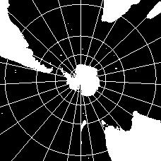
11 Planar or Azimuthal Projection(s) Examples:
12 Pseudo or Unique Projections - The many projections that cannot be easily related to the cylindrical, conical, or Planar surfaces are described as pseudo or unique. - They could be versions of a projection to which changes have been made to reduce or modify the pattern of distortion. - Example: Winkel Tripel Projection - (1921 by Oswald Winkel) - it does not eliminate area, direction, or distance distortions, rather, it tries to minimize the sum of all three; it provides the best balance between size, shape, distance, and direction; more realistic representation of the Earth; lines of latitude are slightly curved; replaced Robinson Projection (also pseudo) in 1998 by the National Geographic Society as the standard map representing the world.
13
14 Maps: Geography s Basic Tool - Elements of a Map: 1. Title: identifies area shown and topic, purpose, or focus 2. Legend: explains meaning of symbols and colours 3. Scale: compares distance between points on the map with actual distance between those on the Earth s surface. Allows the reader to measure distance and to calculate area.


15 Elements of a map (cont d) - Elements of a Map: 4. Date of Publication: indicates if information is recent 5. Borders: set the map apart from other information 6. Directions - Compass: Represented in various ways: a. By direction arrow or symbol b. By the use of latitude and longitude

16 Types of Maps 1. General-Purpose Maps: provide many types of information on one map. Examples include Atlas maps, Wall Maps and Road maps. a. Things found on a general-purpose map include: bodies of water, roads, railway lines, parks, elevation, towns, and cities.

17 Types of Maps 2. Thematic Maps: provide very specific information about a place. They are designed to provide information on one particular topic.
, rivers, railroads (natural and manmade features) in detail.")
18 Types of Maps 3. Topographic Maps: use symbols to show a variety of different features. They are very useful to examine the characteristics of a small area. Example: This map of an area around Banff, Alberta depicts relief (contour lines show elevation), rivers, railroads (natural and manmade features) in detail. It could be used for planning a hiking trip.
A map is a small-scale flat-surface representation of some portion of the earth s surface.
 MAPS AND CHARTS A map is a small-scale flat-surface representation of some portion of the earth s surface. A representation that is designed for plotting navigational information is called a chart. Often
History of Cartography,
 Maps History of Cartography, the art and science of making maps ~2300 BC ~600 BC Early oldest known maps: Babylonian clay tablets. Greek and Roman Ptolemy s (about AD 85-165) "world map" depicted the Old
Chapter 3 Models of the Earth. 3.1 Finding Locations on the Earth. 3.1 Objectives
 Chapter 3 Models of the Earth 3.1 Finding Locations on the Earth 3.1 Objectives Explain latitude and longitude. How can latitude and longitude be used to find locations on Earth? How can a magnetic compass
Name Class Date. For each pair of terms, explain how the meanings of the terms differ.
 Skills Worksheet Chapter Review USING KEY TERMS For each pair of terms, explain how the meanings of the terms differ. 1. true north and magnetic north 2. latitude and longitude 3. equator and prime meridian
Map projections. Rüdiger Gens
 Rüdiger Gens 2 Outline! Relevant terms! Why map projections?! Map projection categories " Projection surfaces " Features preserved from distortions! Map projection examples! Right choice Relevant terms!
2. What does the map scale tell the map reader? a ratio between the actual distance on the ground and the length given to that distance on a map
 AP Human Geography - Damon Name Unit 1 - Intro to Human Geography Hour Map and Globe Skills Review Note: All links in this packet are found on our Wikispace under Map and Globe Skills Review First, read
Georeferencing. datum. projection. scale. The next few lectures will introduce you to these elements. on the Earth, you ll need to understand how
 Georeferencing GOAL: To assign a location to all the features represented in our geographic information data In order to do so, we need to make use of the following elements: ellipsoid/geoid To determine
GIST 3300 / Geographic Information Systems. Last Time. Today
 GIST 3300 / 5300 Last Time Ellipsoids and Datums Today Map Projections Map Projections Today we will build on the concepts of Geographic Coordinate Systems, Ellipsoids and Datums and add the concepts of
Map Projections. Chapter 4 MAP PROJECTION
 Map Projections Chapter 4 Map Projections What is map projection? Why are map projections drawn? What are the different types of projections? Which projection is most suitably used for which area? In this
How can we project a 3D globe onto a 2D display? - Ellipsoids and Datums deal with earth non-sphericity
 Map projections How can we project a 3D globe onto a 2D display? - Ellipsoids and Datums deal with earth non-sphericity http://www.mapovasbirka.cz/english/index_eng.html The world could be mapped like
Shape e o f f the e Earth
 1 Coordinate Systems & Projections Coordinate Systems Two map layers are not going to register spatially unless they are based on the same coordinate system. 2 Contents Shape of the earth Datum Projections
Wayne E. Sirmon GEO 301 World Regional Geography
 Wayne E. Sirmon GEO 301 Geography 301 Geography 301 MAP: A graphic representation of a portion of the earth s surface dawn to scale, as seen from above. Types of Maps Climate maps give general information
MAP PROJECTIONS but before let s review some basic concepts.
 MAP PROJECTIONS but before let s review some basic concepts. Types of Maps General Purpose Topographic Thematic/Choropleth Dot Graduated Circle Isometric/Isolines Isopleth Mental Maps Scale Small-scale
THE EARTH AND ITS REPRESENTATION
 UNIT 7 THE EARTH AND ITS REPRESENTATION TABLE OF CONTENTS 1 THE EARTH AND THE SOLAR SYSTEM... 2 2 THE EARTH S MOVEMENTS... 2 2.1 Rotation.... 2 2.2 The revolution of the Earth: seasons of the year....
Geographers Tools: Maps and their Parts
 MP MKIG Geographers Tools: Maps and their Parts Prof. nthony Grande Hunter ollege Geography Lecture design, content and presentation FG 0616. Individual images and illustrations may be subject to prior
MR. GOFF S WORLD HISTORY UNIT ONE: GEOGRAPHY 5 THEMES OF GEOGRAPHY
 MR. GOFF S WORLD HISTORY UNIT ONE: GEOGRAPHY 5 THEMES OF GEOGRAPHY BYOD BRING YOUR OWN DEVICE IN SMALL GROUPS (3-4), USE YOUR ELECTRONIC DEVICE(S) AND DEFINE THE FOLLOWING VOCAB. WORDS 1. GEOGRAPHY 2.
Use your text to define the following term. Use the terms to label the figure below. Define the following term.
 Mapping Our World Section. and Longitude Skim Section of your text. Write three questions that come to mind from reading the headings and the illustration captions.. Responses may include questions about
Map Projections. Which ones best suit your needs?
 1 z 21 2010-02-20 18:38 Map Projections The Globe Mercator Transverse Mercator Oblique Mercator Space Oblique Mercator Miller Cylindrical Robinson Sinusoidal Equal Area Orthographic Stereographic Gnomonic
Chapter 1: The World of Geography
 Chapter 1: The World of Geography Chapter 1: What is Geography? *It is the study of our earth; our home. OR *Anything that can be mapped! *Geography mixes up the physical and human aspects of our world
First Exam: New Date. 6 Geographers Tools Maps and their Parts 9/14/2017 MAP MAKING MAP MAKING MAP PROJECTIONS MAP PROJECTIONS
 6 Geographers Tools Maps and their Parts Prof. nthony Grande Hunter ollege Geography Lecture design, content and presentation FG 0917. Individual images and illustrations may be subject to prior copyright.
Some of these parallels are very important. In the Northern Hemisphere, there is the Tropic of Cancer and the Arctic Circle.
 PDF 2 Geographic coordinates 1 The geographic coordinates system is network of imaginary horizontal and vertical lines that are drawn on globes or maps. These lines are called parallels (lines of latitude)
Test Bank Chapter 2: Representations of Earth
 Multiple Choice Test Bank Chapter 2: Representations of Earth 1. A rhumb line on a Mercator projection is a line of. a. true size b. true shape c. true compass bearing d. true location 2. Maximum longitude
Maps and Map Projections
 38 The Global Positioning System The Global Positioning System (GPS) is a modern technology for determining a location on Earth. This high-tech system was originally created for military applications but
EXTRA CREDIT Extra Credit Atlas Exercise for Exam I is available on the course home page
 EXTRA CREDIT Extra Credit Atlas Exercise for Exam I is available on the course home page. Submit answers to me using the blue Scantron sheet by Feb. 19, 2019. Once you have completed the exercise, transfer
Map Projections 2/4/2013. Map Projections. Rhumb Line (Loxodrome) Great Circle. The GLOBE. Line of constant bearing (e.g., 292.
 Great Circle. The GLOBE. Line of constant bearing (e.g., 292.") The GLOBE ADVANTAGES Directions True Distances True Shapes True Area True DISADVANTAGES Very small scale with little detail. Costly to reproduce and update. Difficult to carry around. Bulky to store. FACTS
The GLOBE ADVANTAGES Directions True Distances True Shapes True Area True DISADVANTAGES Very small scale with little detail. Costly to reproduce and update. Difficult to carry around. Bulky to store. FACTS
Introduction to Geography
 Introduction to Geography ropic of Cancer 3½ N Arctic Circle 90 N Prime Meridian 0 Arctic Ocean Mississippi R. Appalachian Mts. Europe Rocky Mountains N. America Atlantic Gulf of Ocean Mexico Caribbean
Map Projections. is about presenting the round Earth on a flat surface.map Projections: Vermeer s Cartographer
 Map Projections is about presenting the round Earth on a flat surface.map Projections: Vermeer s Cartographer What is a map projection? A projection is a way to make a flat representation of the Earth
AP Human Geography Chapter 1: Thinking Geographically Key Issue 1: How do Geographers describe where things are?
 AP Human Geography Chapter 1: Thinking Geographically Key Issue 1: How do Geographers describe where things are? Studying Human Geography Physical Geography Physical geography deals with Earth s natural
First Exam: New Date. 6 Geographers Tools. Maps and their Parts 2/16/2018 MAP MAKING MAP PROJECTIONS MAP PROJECTIONS MAP MAKING QUANDRY
 First Exam: ew ate Friday, March 2, 2018. ombination of multiple choice questions and map interpretation. ring a #2 pencil with eraser. ased on class lectures supplementing chapter 1. Review lecture slides.
What is a Map Projection?
 What is a Map Projection? It is how we represent a three dimensional Earth on a flat piece of paper However The process of transferring information from the Earth to a map causes every projection to distort
Map Projections (Part 1)
") 1 Earth is a round, maps are not. Four projection families. Equivalent (Equal Area) projections Preserves relative areas Commonly used for thematic maps Ex: Albers Conformal projections Preserve angles,
1 Earth is a round, maps are not. Four projection families. Equivalent (Equal Area) projections Preserves relative areas Commonly used for thematic maps Ex: Albers Conformal projections Preserve angles,
Introduction to Geography
 Introduction to Geography What is geography? Geography comes from the Greek word Geographia. Geo means earth and graphia means to describe or chart. Geographers study the earth in relation to space and
Introduction to Cartography GEOG 2016 E. Lecture-2 Geodesy and Projections
 Introduction to Cartography GEOG 2016 E Lecture-2 Geodesy and Projections What is Geodesy? The science of geodesy determines: Earth s shape and Interrelation of different points on earth s surface The
EXTRA CREDIT. 6 Geographers Tools. Maps and their Parts MAP MAKING QUANDRY MAP MAKING
 EXTRA CREDIT Extra Credit Atlas Exercise for Exam I is available on the course home page. Submit answers to me using the blue Scantron sheet by Feb. 19, 2019. Once you have completed the exercise, transfer
EXTRA CREDIT. 6 Geographers Tools. Maps and their Parts MAP MAKING QUANDRY MAP MAKING 2/15/19 MAP PROJECTIONS MAP PROJECTIONS
 EXTRA CREDIT Extra Credit Atlas Exercise for Exam I is available on the course home page. Submit answers to me using the blue Scantron sheet by Feb. 19, 2019. Once you have completed the exercise, transfer
What is a map? A Map is a two or three-dimensional model or representation of the Earth s surface. 2-Dimensional map
 What is a map? A Map is a two or three-dimensional model or representation of the Earth s surface. 2-Dimensional map What is a Map Projection? Planar Projection Projection A Projection is a mathematical
What is Geography? *Mixes up the physical and human aspects of our world into one field of study.
 World Geography What is Geography? *It is the study of the earth *Mixes up the physical and human aspects of our world into one field of study. *Shows the relationship between people and the environment.
Map projections. Rüdiger Gens
 Rüdiger Gens Coordinate systems Geographic coordinates f a: semi-major axis b: semi-minor axis Geographic latitude b Geodetic latitude a f: flattening = (a-b)/a Expresses as a fraction 1/f = about 300
Referencing map features: Coordinate systems and map projections
 Referencing map features: Coordinate systems and map projections Coordinate systems and map projections if we want to integrate geographic data from many different sources, we need to use a consistent
Navigation. Longitude and Latitude Foundations of Navigation. MTPs:
 Navigation 3.01 Foundations of Navigation References: FTGU pages 177-178, 184-190 Transport Canada Study and Reference Guide Glider Pilot Canada Flight Training Manual Pilot Navigation http://en.wikipedia.org/wiki/transverse_mercator_projection#spherical_transverse_mercator
Chapter 02 Maps. Multiple Choice Questions
 Chapter 02 Maps Multiple Choice Questions 1. Every projection has some degree of distortion because A. a curved surface cannot be represented on a flat surface without distortion. B. parallels and meridians
Outline. Shape of the Earth. Geographic Coordinates (φ, λ, z) Ellipsoid or Spheroid Rotate an ellipse around an axis. Ellipse.
 Ellipsoid or Spheroid Rotate an ellipse around an axis. Ellipse.") Map Projections Outline Geodesy and map projections Prof. D. Nagesh Kumar Department of Civil Engineering Indian Institute of Science Bangalore 560 012, India http://www.civil.iisc.ernet.in/~nagesh Shape
Map Projections Outline Geodesy and map projections Prof. D. Nagesh Kumar Department of Civil Engineering Indian Institute of Science Bangalore 560 012, India http://www.civil.iisc.ernet.in/~nagesh Shape
Geographic coordinate systems
 1 Geographic coordinate systems In this chapter you ll learn about longitude and latitude. You ll also learn about the parts that comprise a geographic coordinate system including Spheres and spheroids
What is a map? A simple representation of the real world Two types of maps
 Mapping with GIS What is a map? A simple representation of the real world Two types of maps Reference maps showing reference features such as roads, locations, political boundaries, cities etc. Thematic
Using Maps. Using Maps. Using Maps. Using Maps
 A is a visual representation, or model, of part or all of the earth. lines are imaginary lines that run east to west around the globe; they are also known as parallels. They show distances in degrees north
Notes on Projections Part II - Common Projections James R. Clynch February 2006
 Notes on Projections Part II - Common Projections James R. Clynch February 2006 I. Common Projections There are several areas where maps are commonly used and a few projections dominate these fields. An
Geographer s Toolkit. Geography of Canada
 Geographer s Toolkit Geography of Canada www.craigmarlatt.com/school Geographer s Toolkit 1. Parts of a Map Map Symbols Mapping Your Location 2. Types of Maps 3. Political Map of Canada 4. Drainage Map
Geography Can Be Cool. Seriously
 Geography Can Be Cool Seriously Why does geography matter? Geography: the study of looking at every aspect of the Earth s systems, such as human economies, societies, cultures, plants, animals, & climate.
Introduction to Geoinformatics I
 Introduction to Geoinformatics I MAP CONCEPT Definition: 1) A map is a visual representation of an area a symbolic depiction highlighting relationships between elements of that space such as objects, regions,
ROYAL CANADIAN AIR CADETS PROFICIENCY LEVEL FOUR INSTRUCTIONAL GUIDE SECTION 4 EO C USE A VISUAL FLIGHT RULES (VFR) NAVIGATION CHART (VNC)
 NAVIGATION CHART (VNC)") ROYAL CANADIAN AIR CADETS PROFICIENCY LEVEL FOUR INSTRUCTIONAL GUIDE SECTION 4 EO C437.02 USE A VISUAL FLIGHT RULES (VFR) NAVIGATION CHART (VNC) Total Time: 60 min PREPARATION PRE-LESSON INSTRUCTIONS Resources
ROYAL CANADIAN AIR CADETS PROFICIENCY LEVEL FOUR INSTRUCTIONAL GUIDE SECTION 4 EO C437.02 USE A VISUAL FLIGHT RULES (VFR) NAVIGATION CHART (VNC) Total Time: 60 min PREPARATION PRE-LESSON INSTRUCTIONS Resources
2 Mapping Earth Reading Essentials. 2. Contrast What is the difference between a map view and a profile view?
 Mapping Earth Maps What do you think? Read the three statements below and decide whether you agree or disagree with them. Place an A in the Before column if you agree with the statement or a D if you disagree.
Mapping Earth. How are Earth s surface features measured and modeled?
 Name Mapping Earth How are Earth s surface features measured and modeled? Before You Read Before you read the chapter, think about what you know about maps Record your thoughts in the first column Pair
Introduction to Geographic Information Science. Updates/News. Last Lecture. Geography 4103 / Map Projections and Coordinate Systems
 Geography 4103 / 5103 Introduction to Geographic Information Science Map Projections and Coordinate Systems Updates/News Thursday s lecture Reading discussion 1 find the readings online open questions,
FIND PLACES ON GLOBES USING LATITUDE
 GLOBES, MAPS & GRAPHS FIND PLACES ON GLOBES USING LATITUDE AND LONGITUDE LINES FIND PLACES ON MAPS USING A GRID SYSTEM NAME SEVERAL TYPES OF MAP PROJECTIONS AND EXPLAIN THEIR BENEFITS AND SHORTCOMINGS
AS 410 Land Navigation. Chpt 4-1
 AS 410 Land Navigation Chpt 4-1 Overview Types of Maps Map Legends / Scales Latitude and Longitude Orienteering Why? Why important to learn how to read a compass and map? No cell phone coverage Mountain
Geographers Perspectives on the World
 What is Geography? Geography is not just about city and country names Geography is not just about population and growth Geography is not just about rivers and mountains Geography is a broad field that
Introduction to Cartography Part II
 Introduction to Cartography Part II Introduction to Cartography Map Projections GIS GPS Remote Sensing Misrepresentation with Maps Map Projections Mathematical method for systematically transforming a
Map Projections. Displaying the earth on 2 dimensional maps
 Map Projections Displaying the earth on 2 dimensional maps Map projections Define the spatial relationship between locations on earth and their relative locations on a flat map Are mathematical expressions
Importance of Understanding Coordinate Systems and Map Projections.
 Importance of Understanding Coordinate Systems and Map Projections. 1 It is extremely important that you gain an understanding of coordinate systems and map projections. GIS works with spatial data, and,
This week s topics. Week 6. FE 257. GIS and Forest Engineering Applications. Week 6
 FE 257. GIS and Forest Engineering Applications Week 6 Week 6 Last week Chapter 8 Combining and splitting landscape features and merging GIS databases Chapter 11 Overlay processes Questions? Next week
The Wildlife Society Meet and Greet. Come learn about what the UNBC Student Chapter of TWS is all about!
 Georeferencing I GEOG 300, Lecture 4 Dr. Anthony Jjumba 1 The Wildlife Society Meet and Greet Quiz Come learn about what the UNBC Student Chapter of TWS is all about! 5:30 7:30 PM, Wednesday September
About places and/or important events Landmarks Maps How the land is, hills or flat or mountain range Connected to maps World Different countries
 What do you think you know about geography? About places and/or important events Landmarks Maps How the land is, hills or flat or mountain range Connected to maps World Different countries What do you
Mapping Our World Chapter 2
 Mapping Our World Chapter 2 Section 2.1: Latitude and Longitude Maps are flat models of threedimensional objects. For thousands of years people have used maps to define borders and to find places. With
CHAPTER EXIT CHAPTER. Models of Earth. 3.1 Modeling the Planet. 3.2 Mapmaking and Technology. 3.3 Topographic Maps CHAPTER OUTLINE
 EXIT CHAPTER.1 Modeling the Planet.2 Mapmaking and Technology. Topographic Maps CHAPTER OUTLINE CHAPTER.1 Modeling the Planet A flat of Earth is a convenient tool, but it can distort the shape, distance,
Map Projections & Coordinate Systems
 Map Projections & Coordinate Systems 9/7/2017 1 Why? Laying the Earth Flat Need convenient means of measuring and comparing distances, directions, areas, shapes. Traditional surveying instruments measure
Working with georeferenced data. What is georeferencing? Coordinate Systems. Geographic and Projected Coordinate System
 GIS501 Fundamentals of Geographical Information Systems (GIS) Coordinate Systems Working with georeferenced data What is georeferencing? Geographically referenced data which is, in some way, referenced
Planet Classification Schemes Temperature Rings Presence of life Size Composition Moons Distance from Sun Length of day
 Solar noon on Winter Solstice in Fairbanks, Alaska (64º 50 N). Solar angle is 2 ; day length, 3.7 hours (sunrise 11:00, set 2:42). Planet Classification Schemes Temperature Rings Presence of life Size
Cartographic Skills. L.O. To be aware of the various cartographic skills and when to use them
 Cartographic Skills L.O. To be aware of the various cartographic skills and when to use them Cartographic Skills The term cartography is derived from two words: Carto = map graphy = write/draw Cartography
WHERE ARE YOU? Maps & Geospatial Concepts Fall 2012
 WHERE ARE YOU? Maps & Geospatial Concepts Fall 2012 Where are you? Relative location I m at school Absolute Location 45 26 18.07 122 43 50.78 Datums Datums A reference surface of the Earth Used as the
Topographic Map Series:
 DEFINITION OF A MAP A MAP IS A GEOGRAPHIC PREPRESENTATION OF A PORTION OF THE EARTH S SURFACE DRAWN TO SCALE, AS SEEN FROM ABOVE. IT S USES COLORS, SYMBOLS AND LABELS TO REPRESENT FEATURES FOUND ON THE
WHERE ARE YOU? Maps & Geospatial Concepts Fall 2015
 WHERE ARE YOU? Maps & Geospatial Concepts Fall 2015 Where are you? Relative location I m at school Absolute Location 45 26 18.07 122 43 50.78 Where is Boston? Introducing Geodesy, Ellipsoids & Geoids Geodesy
Using Map and Compass Together
 Using Map and Compass Together In situations where you foresee a potential evacuation on foot, where there are no roads, and no indication as to the direction of travel (i.e., road signs), it is recommended
MAP STUDY: INTERPRETATION OF SURVEY MAPS
 MAP STUDY: INTERPRETATION OF SURVEY MAPS Types and Elements of Maps Maps are drawn to represent the Earth on a piece of paper. Maps are used widely to represent the Earth. Maps use signs and symbols in
Map Projections. What does the world look like? AITOFF AZIMUTHAL EQUIDISTANT BEHRMANN EQUAL AREA CYLINDRICAL
 Map Projections What does the world look like? AITOFF AZIMUTHAL EQUIDISTANT BEHRMANN EQUAL AREA CYLINDRICAL 1 CYLINDRICAL EQUAL AREA BONNE CRASTER PARABOLIC 2 ECKERT I ECKERT III ECKERT V There are many
A. Spatial Sense (Working with Maps, Globes, and Other Geographic Tools)
") A. Spatial Sense (Working with Maps, Globes, and Other Geographic Tools) Measuring Distance Using Map Scale All maps are drawn to scale; that is, they are smaller than the things they represent. Scale
A. Spatial Sense (Working with Maps, Globes, and Other Geographic Tools) Measuring Distance Using Map Scale All maps are drawn to scale; that is, they are smaller than the things they represent. Scale
Different types of maps and how to read them.
 Different types of maps and how to read them. A map is a picture or representation of the Earth's surface, showing how things are related to each other by distance, direction, and size. Maps have been
In order to be adequately prepared for a test on this topic you should be able to:-
 Topic 2: MAPPING In order to be adequately prepared for a test on this topic you should be able to:- 1. Find and also provide both FOUR and SIX figure Area and Grid References 2. Calculate distances both
2. GETTING STARTED WITH GIS
 2. GETTING STARTED WITH GIS What are geographic information systems and what are they used for? ArcGIS: ArcMap, ArcCatalog and ArcToolbox Vector data vs. raster data vs. attribute tables Polygons, polylines,
Compass Basics. Quick Map Basics Review For Compass Use
 Compass Basics Quick Map Basics Review For Compass Use A topographic map tells you where things are and how to get to them, whether you're hiking, biking, hunting, fishing, or just interested in the world
EnvSci360 Computer and Analytical Cartography
 EnvSci360 Computer and Analytical Cartography Lecture 3 Geodesy Map Projections, Datums, and Coordinate Systems 1 Geodesy The science of measuring and representing the shape and size of the earth, and
Lecture 4. Coordinate Systems & Projections
 Lecture 4 Coordinate Systems & Projections Outline Geodesy Geoids Ellipsoids Geographic Coordinate Systems Magnetic North vs. True North Datums Projections Applying Coordinate Systems and Projections Why
2. Environmental issues in the relationship of humankind to the environment
 Course Goals to Understand 1. Processes operating on the earth s surface Atmosphere Lithosphere Hydrosphere Biosphere 2. Environmental issues in the relationship of humankind to the environment 3. Science
Dirty REMOTE SENSING : Lecture 8 A mapping interlude..
 Dirty REMOTE SENSING : Lecture 8 A mapping interlude.. Stuart Green Teagasc Spatial Analysis Group Stuart.green@teagasc.ie Web for the Week: http://electronics.howstuffworks.com/gps.htm http://www.cstars.ucdavis.edu/classes/ers186-w03/lecture17/lecture17.ppt
Cartography the art of making maps
 Cartography the art of making maps A map is a drawing or a picture of the earths surface, showing how things are related to each other by distance, direction and size. Maps are used for: Navigation Distance
What Is a Globe? Hemispheres. Main Idea Globes and maps provide different ways of showing features of the earth. Terms to Know
 r Main Idea Globes and maps provide different ways of showing features of the earth. Terms to Know hemisphere latitude longitude scale bar scale relief elevation contour line What Is a Globe? A globe is
Number in your response section 1-5. Write the letter to the matching Theme of Geography. (Do not use your notes)
") Matching/Review Number in your response section 1-5. Write the letter to the matching Theme of Geography. (Do not use your notes) 1. Location a. The ability of people, goods, and ideas to spread from one
Matching/Review Number in your response section 1-5. Write the letter to the matching Theme of Geography. (Do not use your notes) 1. Location a. The ability of people, goods, and ideas to spread from one
Topographic Maps. Take Notes as you view the slides
 Topographic Maps Take Notes as you view the slides Lesson Objectives Define a topographic map and state its uses. Describe how contour lines show the elevations, shape, and slope of the land. Identify
Chapter 2: Studying Geography, Economics, and Citizenship
 Chapter 2: Studying Geography, Economics, and Citizenship Lesson 2.1 Studying Geography I. Displaying the Earth s Surface A. A globe of the Earth best shows the sizes of continents and the shapes of landmasses
Projections Part I - Categories and Properties James R. Clynch February 2006
 I. Introduction and References Projections Part I - Categories and Properties James R. Clynch February 2006 The world is, approximately, a sphere. Maps are flat. Making maps requires some method of putting
Introduction to Cartography Part I
 Introduction to Cartography Part I Introduction to Cartography Maps vs. Globes General Types of Maps Standard Map Features Maps versus Globes Map: a representation of the world, or part of it, in two dimensions
Understanding Projections
 GEOGRAPHY SKILLS 1 Understanding Projections The earth is a sphere and is best shown as a globe. For books and posters, though, the earth has to be represented as a flat object. To do this, mapmakers create
GTECH 201 Geographic Methods
 GTECH 201 Geographic Methods Map Quiz What is Geography? Administravia Course web site Accounts, printing, email (Hunter only) Send me an email with: name, geo courses taken, major/minor, Fr/So/Jr/Sr Types
Georeferencing, Map Projections, Cartographic Concepts. -Coordinate Systems -Datum
 Georeferencing, Map Projections, Cartographic Concepts -Map Projections -Coordinate Systems -Datum Map projection is "the process of systematically transforming positions on the Earth's spherical surface
Key Issue 1: How Do Geographers Describe Where Things Are?
 Key Issue 1: How Do Geographers Describe Where Things Are? Pages 5-13 and some information from pages 15-18. ***Always keep your key term packet out whenever you take notes from Rubenstein. As the terms
Latitude and Longitude Pre Test
 Name Date Latitude and Longitude Pre Test Multiple Choice Directions: For questions, 1 10 circle the answer that letter that best answers the question. Each question is worth 1 point each. 1. To locate
Topographic Maps and Landforms Geology Lab
 Topographic Maps and Landforms Geology Lab Ray Rector: Instructor Today s Lab Activities 1) Discussion of Last Week s Lab 2) Lecture on Topo Maps and Elevation Contours 3) Construct Topographic Maps and
Map Skills and Geographic Tools
 Name: Period: Map Skills and Geographic Tools TEKS: 8.9C interpret topographic maps and satellite views to identify land and erosional features and predict how these features may be reshaped by weathering
Map Skills Unit. Note taking unit
 Map Skills Unit Note taking unit Introduction To learn about the Earth, we are going to learn about two geographic tools you can use.globes and maps. Globe A globe is a round model of the planet Earth
Plane coordinates ~~~~~~~~~~
 Coordinate Systems & Map Projections Geographic coordinates A Basic Introduction to Coordinate Systems & Map Projections Latitude & longitude Angles Parallels & meridians Lines Plane coordinates ~~~~~~~~~~
1. Origins of Geography
 II. ORIGINS AND BRANCHES OF GEOGRAPHY My Notes A. Origins of Geography Unit One 6 Before carefully examining the tools of the geographer, it would be useful to examine the origins and roots of this ancient