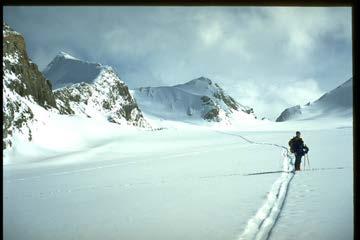
Classroom Outing
|
|
|
- Daniela Richard
- 5 years ago
- Views:
Transcription
1
2 Classroom Outing
3
4
5
6
7

8 Government Of Canada Government Of BC, Printed by Gotrekkers: Gemtrek Mark Klassen et al John Baldwin Chrismar

9 Symbols Scale Colors Contour Lines Magnetic Declination Grid systems and map datums

10 Agricultural Building Geographic / Geologic

11 Elevation Land Cover


12 Man Made Hydrological Natural Hydrological Miscellaneous Transportation Railway
13 Road Recreation
14 Expressed as a ratio 1:50,000 1:63,360 1:62,500 1:25,000 1:24,000 1:20,000
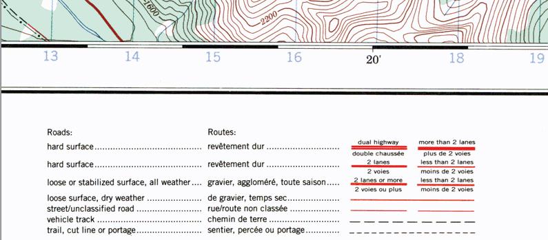
15 Color Red Blue Black Green White with blue contour lines White with brown contour lines Brown Purple Meaning Roads Water Features, UTM Grid Minor Roads, trails, railroads,buildings, benchmarks, Forested areas Glacier or permanent snowfield Dry area without substantial forest Contour lines and elevation Revisions to an existing map
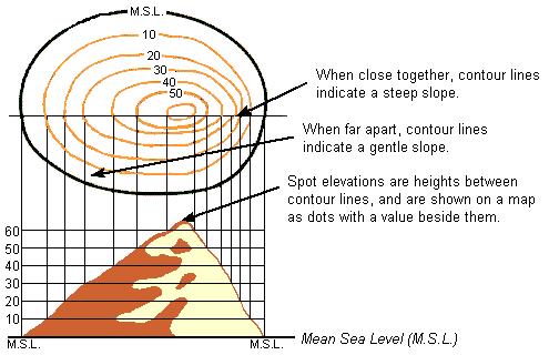
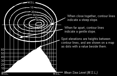
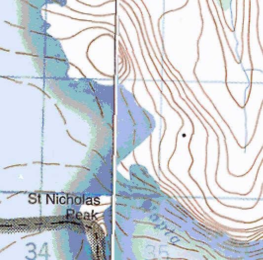
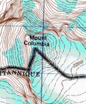
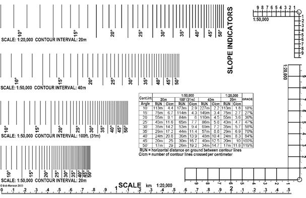
16 Join areas of equal elevation Various maps have different distances between lines: 20m, 40m, 50m, 80m, 100m, 100 ft Flat areas have no contour lines Gentle slopes: widely spaced contour lines Steep slopes: closely spaced contour lines Cliffs: lines extremely close or touching
17
18

19
20

21
22
23
24
25
26
27
28
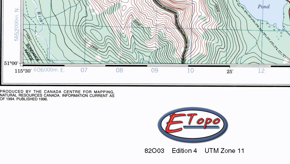
29
30
31
32 The Universal Transverse Mercator Grid Map Projections Earth is a sphere, any representation of its surface on a flat sheet of paper involves distortion. Relatively insignificant for maps showing small parts of the Earth, such as city maps. Quite considerable for maps of whole countries or continents. Map-makers decision is not whether to have a distortion on a map, but what type of distortion. Geometrical schemes represent the curved surface of the Earth on map sheets known as map projections. All projections have certain advantages and disadvantages Size and shape of the country determines the most suitable projection for its system of topographic maps. Very large countries must be divided into strips, called zones, which are projected onto a plane. One is the Transverse Mercator called this because the strips run north-south rather than eastwest along the equator, as in the standard Mercator projection. Special type is the Universal Transverse Mercator (UTM) Projection. The Centre for Topographic Information uses the UTM Projection for its popular National Topographic System (NTS) series at 1/ and 1/ scales. Tied in with this projection is the rectangular grid, a system for finding points on maps. All topo maps also carry lines of longitude and latitude.
33 To understand how the projection works, imagine the Earth as an orange, with all geographical features and the parallels and meridians already drawn in. Now imagine taking a knife and, after slicing off small circles at the poles, making a straight north-south cut in the peel of the orange and repeating this north-south cut, at equal intervals, until 60 strips or zones have been detached Figure 1 - Shape of a UTM Zone. The Universal Transverse Mercator Grid Map Projections

34 Each of these zones forms the basis of a separate map projection. The flattening may be visualized as a strip of orange peel placed on a level surface. By depressing its centre, one could force the peel to flatten until all of it touches the smooth surface. This results in a slight distortion of the geographical features within the zone, but because the zone is relatively narrow, the distortion is small and may be ignored by most map-users. Because the globe is 360 in circumference, a division into sixty vertical zones gives each zone the width of 6 of longitude. By international usage these zones have been numbered 1 to 60. Sixteen of the zones, bearing numbers 7 to 22, cover Canada, as shown in Figure 2, below. The Universal Transverse Mercator Grid Map Projections
35 The Universal Transverse Mercator Grid Map Projections This UTM grid uses as its basic element of identification, lines. These lines are standard on all UTM maps. They are drawn on our "orange strips" after the strips have been flattened so the grid lines are perfectly straight and undistorted. The basic grid lines, both horizontal and vertical, are drawn metres (100 km) apart. All vertical lines run parallel to the central meridian of each zone. All horizontal lines run parallel to the equator. Parallels of latitude shown on our UTM maps are not parallel to the equator, or to each other, because they are slightly distorted by the flattening. The equator itself is not distorted by the Transverse Mercator projection.
36 The Universal Transverse Mercator Grid Map Projections The squares formed by the intersection of the metre lines are almost always further subdivided by metre lines, metre lines, and even 100-metre lines, depending on the scale and purpose of the map. Most maps show less than the width of a UTM zone, but information relating the map to the zone and defining the grid spacing, is always provided on the margin, for example: ONE THOUSAND METRE UNIVERSAL TRANSVERSE MERCATOR, GRID ZONE 17 The beauty of the UTM rectangular grid is that by using a brief code consisting of zone and grid-line numbers it is possible to identify any point in Canada, even if that point is not otherwise marked or identified on any map.
37 The Universal Transverse Mercator Grid Map Projections Horizontal lines are designated by their distance from the equator in metres. Canada's southernmost point is about metres from the equator, all horizontal lines in Canada have a "northing" value above that figure. Zones never attain the full width of metres In northern Canada, zone widths shrink to as little as metres ( metres on either side of the central meridian). Vertical lines are counted from the central meridian or metre line, those to the left of it having an "easting" value of less than metres, and those on the right having a value above that. The number of metres north of the equator represented by the bottom horizontal grid line on a map is always shown in the lower left-hand corner of the map. The number of metres east of the zero vertical line represented by the left vertical grid line is also shown in the lower left-hand corner. If a given point on a map is positioned exactly at the intersection of a vertical and horizontal line, its location may be read off simply from the map margins. Its full designation or its "coordinates" would include the zone number, followed by the easting and northing values. On a metre grid, these coordinates might read: Zone 14, , The values of the first vertical and horizontal lines appearing in the southwest corner of the map are given in full. The other grid lines are numbered in an abbreviated fashion. Few points, however, are conveniently located at grid intersections. Usually the point to be described is somewhere between lines. In this case, it is necessary to measure or estimate the distance to the nearest vertical line to the west and to the nearest horizontal line to the south and to add these metric values to the grid values given at the margin.
38 If a point is located 400 metres east of the vertical line of , and 200 metres north of the horizontal line of , its coordinates would be: Zone 11, , With these three numbers, any point on the northern hemisphere can be unmistakably identified. There is a similar reference in the southern hemisphere, but confusion never results from this. The civilian system of designating UTM Grid coordinates is straightforward and, since it uses only numbers, it can be handled by digital mapping software and Geographic Information Systems (GIS), an important consideration with any kind of technical data. It does, however, require the use of large and somewhat cumbersome figures. The Universal Transverse Mercator Grid Map Projections

39 With a full grid reference of: , Sometimes it will be shown as To get the full reference: Split in half i.e. 574 and 762 For both, add two zeros on the end: and For the easting, look at the map; is between and The full number starts with a 3 so the full easting is For the northing, look at the map; is between and On the map, the full number starts with a 54 so the full northing is The Universal Transverse Mercator Grid Truncated Grid References

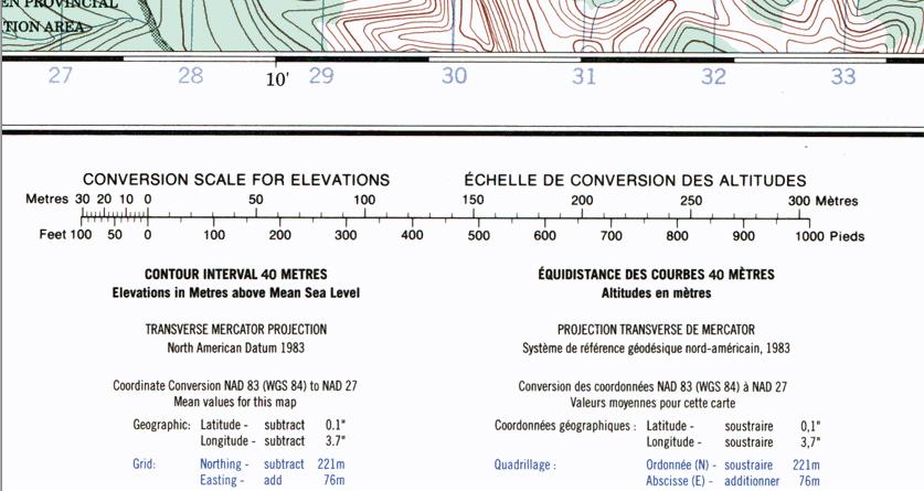
40 A Map Datum is a mathematical model describing the Earth The Earth is not exactly round There are three datums that we use in North America NAD 27 NAD 83 WGS 84 NAD 83 and WGS 84 are functionally the same Kananaskis Country Trail Books use NAD 27 National topographic maps use a mix of NAD 27 and NAD 83 Gemtrek Maps use NAD 83 BC Government Maps use NAD 83 To convert from NAD 83 to NAD 27: Northing Subtract 221; Easting add 76
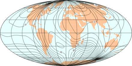
41 A compass points to magnetic north; but this may not be the same as grid north, which depends on your locality. If you live close to the imaginary line that runs from Thunder Bay through Savant Lake, in northern Ontario, northwest through Churchill, Manitoba, you're in luck. Here your compass north is approximately the same as grid north. But if you live east of this line, your compass points off to the west, while west of that line it points off to the east. The reason is that the North Magnetic Pole, which attracts the compass needle, is situated at 81.3 N, W (2001). (Visit the Geological Survey of Canada's Canadian National Geomagnetism Program Web Site for more information about the North Magnetic Pole.)


42 North Magnetic Pole The Earth's magnetic field is shaped approximately like that of a bar magnet. It has two magnetic poles, one in the Canadian arctic, referred to as the North Magnetic Pole, and one off the coast of Antarctica, south of Australia, referred to as the South Magnetic Pole. At the North Magnetic Pole the Earth's magnetic field is directed vertically downward relative to the Earth's surface. Magnetic dip, or inclination is 90. The North Magnetic Pole is drifting across the Canadian Arctic. The Geological Survey of Canada keeps track of this motion by periodically carrying out magnetic surveys to redetermine the Pole's location
43

44 Parts Of The Compass
45 Base plate and rotating housing Sighting mirror Luminous points for use in the dark Declination adjustment Designed for your latitude band

46

47
48 Iron will affect the compass Magnetic fields will affect the reading (electrical lines generate magnetic fields) Functioning electronics can generate magnetic fields. Examples: Avalanche transceiver GPS Digital camera MP3 player Cell phone VHF Radio Most compasses are designed to be used within a specific latitude range Must be held level when being used
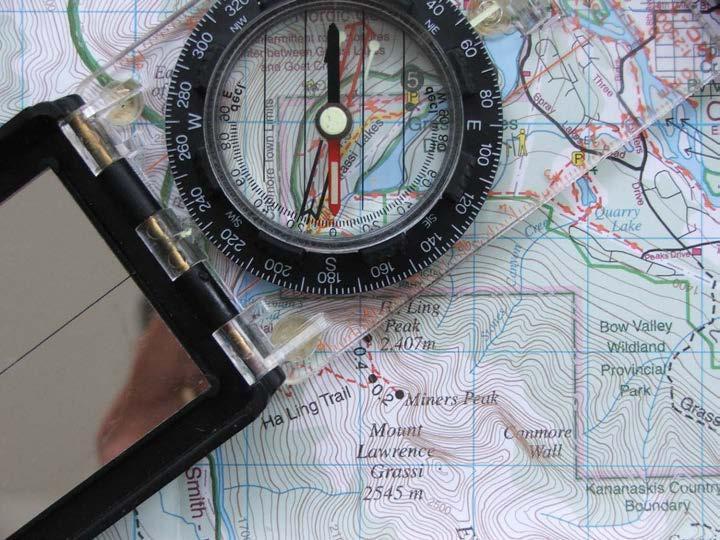
49
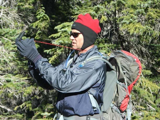
50

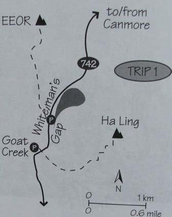
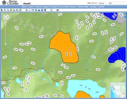
51 What is the UTM grid reference for the summit of Ha-Ling Peak? 11U What is the UTM grid reference for the picnic table at Quarry Lake? 11U Where is the following UTM grid reference located?: NAD 83, 11U, e618300, n ACC Clubhouse Where is the following UTM grid reference located?: NAD 83, 11U, e614800, n Old Goat Glacier trailhead What is the bearing from Ha-Ling Peak to the picnic table at Quarry Lake 53 What is the distance from Ha-Ling Peak to the picnic table at Quarry Lake 2.5 km
52 An altimeter measures the local atmospheric pressure of the air just like a barometer. This is usually expressed in inches or millibars of Mercury. The altimeter displays the current altitude on a dial with a needle or with a digital display. Since atmospheric pressure is constantly changing due to weather, you must calibrate the altimeter by first setting it when you are at a known elevation. Say you arrive at the trail head parking lot which the map indicates is at 2,400 feet (730 meters). Set your altimeter for 2,400 feet (730 meters). As you hike the altimeter shows the current altitude as your elevation increase or decreases. In order to maintain accurate readings you should recalibrate your altimeter several times each day. Recalibrate your altimeter reading before you go to bed. If the altimeter reads a lower altitude the next day, then the atmospheric pressure has gone up during the night (typically indicating stable or improving weather). If the altimeter reads a higher altitude, then the atmospheric pressure is falling (indicating potential stormy weather). You can use your altimeter in navigation as another information source to help locate your position. If the altimeter is properly calibrated, you know that you are at a specific altitude. Think of this altitude as corresponding to a particular contour line on your map. This may be enough to give you a very accurate fix on your location. If you are hiking up a trail and it crosses a particular altitude (contour line) at only one point, then you know exactly where you are.
53 3 Hour Pressure Decrease Altimeter Increase Recommended Action millibars 6 12 meters None except normal monitoring of weather conditions millibars meters Watch sky for thickening and or lowering clouds. Watch for increasing shifting winds to east or southeast millibars meters Same as above. Consider aborting due to high winds and or severe storm. 2.4 millibars or more 24 meters or more Run away!
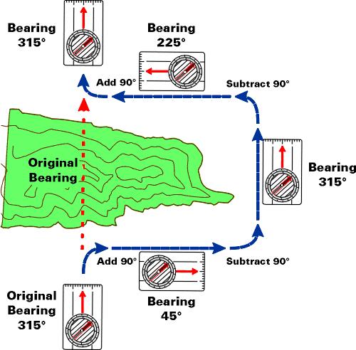
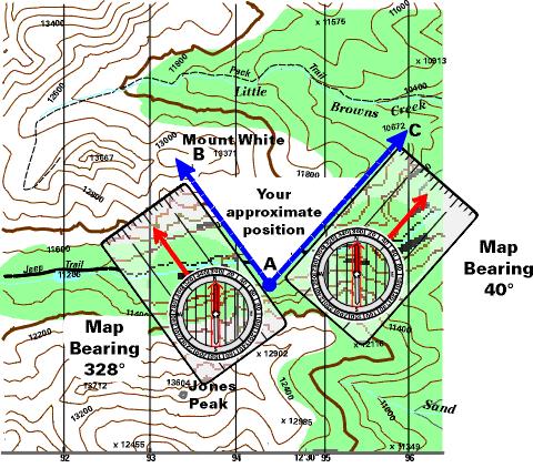
54 Key tool is the map Compass, altimeter and GPS work with the map to help you locate where you are and where you wish to go Of the three tools used with a map, the most important is the compass
55

56 1. Point the compass direction of travel arrow to the destination on the land. 2. Rotate the compass housing until the north orienting arrow of the compass housing lines up with the red magnetic needle. This is referred to as "boxing the needle," since you want the needle to be inside the box defined by the orienting arrow. The north orienting arrow must be pointing in the same direction as the red (north) magnetic needle. Your compass will look like the photo with the needle boxed. 3. Read the bearing (in degrees) from the degree dial at the point on the compass base plate.
57 Walking a Bearing Taken from the Land: 1. After taking the bearing, as described earlier, hold the compass level and in front of you, so that the direction of travel arrow points to the destination. 2. Rotate your whole body until the magnetic needle lies directly over the orienting arrow. Make sure the north end of the magnetic needle points to N on the compass housing. The direction of travel arrow points to the destination. 3. Site a prominent feature to which your direction of travel arrow points. Walk to that feature. Continue to sight on other features along the bearing and walk to them, until you reach your destination. Walking a Bearing Taken from the Map: To walk a bearing taken from the map, you may need to correct for declination if you did not orient the map to magnetic north before you took your bearing. Once you have corrected for declination, follow the same procedure as indicated above for walking a bearing taken from the land. Techniques for Walking a Bearing: Sometimes the terrain isn't always so cooperative to let you just follow your bearing in a straight line so there are a number of techniques to use when traveling on a bearing. Line of Sight Walk to an obvious landmark a tree or boulder that is directly on the bearing. Then take another bearing on the next obvious landmark and walk to that. Keep it up until you reach your destination. By going to intermediate landmarks, you minimize the chances of veering off your bearing.
58

59 Aiming Off: It is almost impossible to walk a perfect bearing. In most cases your error can be anywhere from 3-5. This is known as lateral drift Being off just a few degrees can make a major difference after several kilometers. Therefore, rather than head straight for your target, it is best to deliberately aim to one side of your target (left or right). Then you will know whether to turn right or left and walk to the target.

60 Baselines: Baselines are helpful because they provide a large target to aim for. A baseline is a reference line that lies across your course. It can be a trail, cliff face, road, stream, or other feature. You can combine a baseline with aiming off to help navigate Find a baseline near your destination, then aim off of it. When you hit the baseline, you now know which direction to turn to walk along the baseline to reach your destination
61 Triangulation Triangulation is used to locate your position when two or more prominent landmarks are visible. Even if you are not sure where you are, you can find your approximate position as long as you can identify at least 2 prominent landmarks (mountain, end of a lake, bridge, etc.) both on the land and on your map. 1. Orient the map. 2. Look around and locate prominent landmarks. 3. Find the landmarks on the map (preferably at close to 90 degrees apart). 4. Determine the bearing of one of the landmarks. 5. Place the compass on the map so that one side of the base plate points toward the landmark. 6. Keeping the edge of the base plate on the symbol, turn the entire compass on the map until the orienting lines are parallel to the north/south UTM grid lines. 7. Draw a line on the map along the edge of the base plate, intersecting the prominent landmark symbol. Your position is somewhere along this line. 8. Repeat this procedure for the other prominent landmark. The second landmark should be as close to 90 degrees from the first as possible. Your approximate position is where the two lines intersect. 9. You can repeat this process a third time to show an area bounded by three lines. You are located within this triangle. 10. If you are located on a prominent feature marked on the map such as a ridge, stream, or road, only one calculation from a prominent landmark should be necessary. Your position will be approximately where the drawn line intersects this linear feature.
62

63 You are hiking up the trail to Mt. Fairview and your calibrated altimeter reads 2,600 meters. The X marks your location.
64 Mapping Software Google Maps Google Earth Other Internet Resources
65 Map and Roamer Clinometer Compass Ski Poles 50 cm cm cm cm - 30
66 General Considerations Pacing Rest step Avoid side hilling If you can see destination from afar study it. If you have a digital camera, take a photo to refer to later. Watch for hazards, i.e. cornices and avalanche slopes. Orient yourself at the trailhead. Look at your map and identify some prominent landmarks. Keep pack weight down.
67 General Considerations Pacing Rest step Avoid side hilling If you can see destination from afar study it. If you have a digital camera, take a photo to refer to later. Watch for hazards, i.e. cornices and avalanche slopes. Orient yourself at the trailhead. Look at your map and identify some prominent landmarks. Keep pack weight down. Factors To Consider When Plotting Route Steepness Ground cover (i.e. brush, swamp, rubble) Is there a trail? Aesthetics Environmental impact Topo Maps Google Earth Guide Books Locals Rangers / Wardens / Guides Sources Of Information
68 Whiteout Tips Before it happens Have a plan prepared before it happens. Continuously monitor where you are on your map. When you are caught Rope up. Second on rope carries compass and controls the leaders directions. Use wands to count ropelengths. One ropelength is ~ 50 meters. Use a prussic cord on end of pole and throw downhill. Ski to it and repeat. Once a track is in, it is easier for the rest of the group. Try to find handrails. Wait it out.
69 Naismith s Rule For every 5km of easy going, allow 1 hour For every 3km of easy scrambling, allow 1 hour For every 1km of rough land, deep sand, soft snow or thick bush, allow 1 hour Add an extra hour for every 500m up (cumulative) Add an extra hour for every 1000m down (cumulative) Add an extra hour for every five hours, to allow for fatigue.
70
71 Proposed Trip: Bow Hut to Balfour Hut Weather forecast: A mix of sun and cloud with a chance of a flurry (on the Wapta Icefield this translates into a real chance of whiteout conditions Avalanche forecast is: BTL Moderate, TL Considerable and A High (note: avalanches occur most frequently on slopes of ; occasionally on slopes to 25 when the hazard is high) Bow hut is at: NAD27 11U Balfour hut is at: NAD83 11U
72 Cell Phone Satellite Phone VHF Radio SPOT Device Signaling with a mirror Arm signals with helicopter
73
Using Map and Compass Together
 Using Map and Compass Together In situations where you foresee a potential evacuation on foot, where there are no roads, and no indication as to the direction of travel (i.e., road signs), it is recommended
Compass Basics. Quick Map Basics Review For Compass Use
 Compass Basics Quick Map Basics Review For Compass Use A topographic map tells you where things are and how to get to them, whether you're hiking, biking, hunting, fishing, or just interested in the world
Navigating with Map & Compass. Nevada County Sheriff s Search & Rescue
 Navigating with Map & Compass Nevada County Sheriff s Search & Rescue Objectives Very Practical Teach you how to go from point A to point B Go from the wilderness (real world) to a map and visa versa Agenda
Chapter 3 Models of the Earth. 3.1 Finding Locations on the Earth. 3.1 Objectives
 Chapter 3 Models of the Earth 3.1 Finding Locations on the Earth 3.1 Objectives Explain latitude and longitude. How can latitude and longitude be used to find locations on Earth? How can a magnetic compass
Orienteering Maps & Map Reading Latitude and Longitude Scale
 Orienteering Maps & Map Reading A map is a two-dimensional representation of the three-dimensional world you'll be hiking in. All maps will have some basic features in common and map reading is all about
B. Topographic maps are also called. contour maps
 Topographic Maps Introduction A. Topographic maps are essential tools in geologic and engineering studies because they show the configuration of Earth's surface in remarkable detail and permit one to measure
The Tacoma Mountaineers Wilderness Navigation
 The Tacoma Mountaineers Wilderness Navigation Navigation Fundamentals Navigation in mountainous terrain and wilderness areas requires a set of skills, of which using a map and compass is only one part.
Navigating for Scouts A Self-teaching Guide to Navigation with Map and Compass
 Don Burgess, November 2003 Materials topographic maps Navigating for Scouts A Self-teaching Guide to Navigation with Map and Compass metric ruler orienteering compass 30 M/5 Hamilton-Burlington 41 I/13
Topographic Map Series:
 DEFINITION OF A MAP A MAP IS A GEOGRAPHIC PREPRESENTATION OF A PORTION OF THE EARTH S SURFACE DRAWN TO SCALE, AS SEEN FROM ABOVE. IT S USES COLORS, SYMBOLS AND LABELS TO REPRESENT FEATURES FOUND ON THE
King County Explorer Search and Rescue. Course B Map & Compass
 King County Explorer Search and Rescue Course B Map & Compass Disclaimer The intent of this presentation is to provide a basic overview of maps, compasses, and location finding. It is not meant to be a
Topographic Maps and Landforms Geology Lab
 Topographic Maps and Landforms Geology Lab Ray Rector: Instructor Today s Lab Activities 1) Discussion of Last Week s Lab 2) Lecture on Topo Maps and Elevation Contours 3) Construct Topographic Maps and
OA Guide to Map & Compass. The Backpacker's Field Manual by Rick Curtis
 OA Guide to Map & Compass part of The Backpacker's Field Manual by Rick Curtis Published by Random House 1998 This material is taken from Chapter 6 - Wilderness Travel from The Backpackers Field Manual
Red Star Navigation. Bearings:
 Red Star Navigation Bearings: The main focus in Red Star Navigation is how to use a compass and in particular compass bearings. It is important for cadets to describe bearings as this will assist them
What is a map? A Map is a two or three-dimensional model or representation of the Earth s surface. 2-Dimensional map
 What is a map? A Map is a two or three-dimensional model or representation of the Earth s surface. 2-Dimensional map What is a Map Projection? Planar Projection Projection A Projection is a mathematical
BUSH NAV BUSH NAV DAY Navigation for Bush Navigation Day. November. WhitehorseD AY. Section 1 Registration, Maps & Checkpoints
 BUSH DAY Navigation for Bush Navigation Day Robert Kirwan, Nunawading SES W NW N NE E If you have little or no bush navigation experience then you will have been teamed up with members that have that experience
OA Guide to Map & Compass - Part 1
 OA Guide to Map and Compass - Part 1 OA Guide to Map & Compass - Part 1 part of The Backpacker's Field Manual by Rick Curtis published by Random House 1998 Buy it now at Amazon.com This material is taken
Butte County Fire Department
 Butte County Fire Department Basic Land Navigation Verification Sheet I verify that Print Supervisor s name has completed the Print Employee s name Basic Land Navigation self study guide on. Date Attached
GPS Measurement Protocol
 GPS Measurement Protocol Purpose To determine the latitude, longitude, and elevation of your school and of all your GLOBE sites Overview The GPS receiver will be used to determine the latitude, longitude
Map Reading & Compass Use
 Spring 2013 Kestrel Land Trust Page 2 / 10 Contents Map Basics... 3 Map Types... 3 Terrain Association... 4 Estimating Distance: Pacing... 4 Contour Lines... 5 Navigating with a Compass... 6 Compass Types...
56H. This system allows definition of points on the Earth s surface to within 100 meters. Page 20. Navigation Systems Basics of Maps
 Grid References Many maps are provided with the standard grid overlaying them. This provides a simple and accurate method for finding features on the map. It is a network of intersecting parallel lines
USING THE MILITARY LENSATIC COMPASS
 USING THE MILITARY LENSATIC COMPASS WARNING This presentation is intended as a quick summary, and not a comprehensive resource. If you want to learn Land Navigation in detail, either buy a book; or get
USING THE MILITARY LENSATIC COMPASS
 USING THE MILITARY LENSATIC COMPASS WARNING This presentation is intended as a quick summary, and not a comprehensive resource. If you want to learn Land Navigation in detail, either buy a book; or get
CHAPTER EXIT CHAPTER. Models of Earth. 3.1 Modeling the Planet. 3.2 Mapmaking and Technology. 3.3 Topographic Maps CHAPTER OUTLINE
 EXIT CHAPTER.1 Modeling the Planet.2 Mapmaking and Technology. Topographic Maps CHAPTER OUTLINE CHAPTER.1 Modeling the Planet A flat of Earth is a convenient tool, but it can distort the shape, distance,
APPENDIX A GLOSSARY. Appendix A.1
 APPENDIX A GLOSSARY Appendix A.1 Appendix A.2 Back Bearing A back bearing is measured from the object to your position. It is the exact opposite of a direct bearing. Base Line An imaginary line on the
Basic Map Skills for the Outdoors
 Geography 80-20 80% of what there is to know, for 20% of the sweat Basic Map Skills for the Outdoors Map Scale Map source: US Geological Survey Four ways to indicate map scale: Representative fraction
2 Mapping Earth Reading Essentials. 2. Contrast What is the difference between a map view and a profile view?
 Mapping Earth Maps What do you think? Read the three statements below and decide whether you agree or disagree with them. Place an A in the Before column if you agree with the statement or a D if you disagree.
What is a map? Understanding your map needs
 What is a map? A map is simply a drawing or picture of a landscape or location. Maps usually show the landscape as it would be seen from above, looking directly down. As well as showing the landscape of
Latitude and Longitude
 U n i t 3 M a p p i n g P a g e 1 Latitude and Longitude Note: These coordinates are always expressed LATITUDE/LONGITUDE!!! Coordinate System: Using and to find your position on Earth. LATITUDE LATITUDE
Lab Topographic Maps. Name: Partner: Purpose. Background Information
 Lab Topographic Maps Name: Partner: Purpose The purpose of this lab is to familiarize you with graphic representations of the Earth s surface primarily maps. Simple line maps show the spatial relationship
AS 410 Land Navigation. Chpt 4-1
 AS 410 Land Navigation Chpt 4-1 Overview Types of Maps Map Legends / Scales Latitude and Longitude Orienteering Why? Why important to learn how to read a compass and map? No cell phone coverage Mountain
Map and Compass Skills
 Map and Compass Skills Grade levels: 5-12 In a Nutshell Given a map and compass, students will be able to find a location on the map, chart a course to that location with the compass, and find that location
Butte County Fire Department
 Butte County Fire Department Basic Land Navigation Verification Sheet I verify that Print Supervisor's name Print Employee's name has completed the Basic Land Navigation self study guide on Date Attached
ORIENTEERING I.E.S. JUANA DE CASTILLA ORIENTEERING. 3rd E.S.O. SECOND TERM P.E. DEPARTMENT
 3rd E.S.O. SECOND TERM 1 Orientation is the set of systems that allows us to recognize at all times: The situation of the cardinal points The place where we are The direction to take to reach the desired
LEADING CADET. Navigation with Map and Compass Navigation is about knowing where you are on the map
 LEADING CADET Navigation with Map and Compass Navigation is about knowing where you are on the map Revision Notes Learning Outcome 1 Be able to find a position with an Ordnance Survey map using the physical
Navigation. A question. Take a map and remove the actual map and what are you left with?
 Map reading is part art and part skill. The art comes from practice and the skill from following a few simple rules. Here BGMA will take a step-by-step look at how to become a good (dare we say, skilled)
USING THE MILITARY LENSATIC COMPASS
 USING THE MILITARY LENSATIC COMPASS WARNING This presentation is intended as a quick summary, and not a comprehensive resource. If you want to learn Land Navigation in detail, either buy a book; or get
Chapter 3 SECTION 1 OBJECTIVES
 Chapter 3 SECTION 1 OBJECTIVES Distinguish between latitude and longitude and locate coordinates on maps. Explain how latitude and longitude can be used to locate places on Earth s surface. Explain the
Mapping Earth. How are Earth s surface features measured and modeled?
 Name Mapping Earth How are Earth s surface features measured and modeled? Before You Read Before you read the chapter, think about what you know about maps Record your thoughts in the first column Pair
REVISION: MAPWORK 18 SEPTEMBER 2014
 REVISION: MAPWORK 18 SEPTEMBER 2014 Lesson Description In this lesson we revise: Various mapwork calculations Summary Relative Position Bearing is the angular (angle) distance between two points True Bearing
Chapter 1 Overview of Maps
 Chapter 1 Overview of Maps In this chapter you will learn about: Key points when working with maps General types of maps Incident specific maps Map legend and symbols Map sources A map is a navigational
Earth Science Regents Reading Topographic Maps
 Earth Science Regents Reading Topographic Maps Name Period Quick Tutorial on Degrees, Minutes, and Seconds of Latitude and Longitude A degree of latitude on the surface of the earth is about 70 miles long.
Unit I: Earth Dimensions. Review Book pp.19-30
 Unit I: Earth Dimensions Review Book pp.19-30 Objective #1 Describe the actual shape of the Earth and explain 3 pieces of evidence for its actual shape. Earth s Shape The Earth appears to be the shape
COORDINATE SYSTEMS: LOCATING YOURSELF ON A SPHERE
 NAME DATE PARTNER(S) COORDINATE SYSTEMS: LOCATING YOURSELF ON A SPHERE Activity 1: Getting Your Bearings 1. Close your eyes and point to the north. Did you point up? Why or why not? Up is the #1 answer.
Trail Life USA High Adventure Training Land Navigation Module. Dennis Conte
 Trail Life USA High Adventure Training Land Navigation Module Dennis Conte Navigating With GPS and a MAP Let s Talk about your GPS Hand Held Tool. Is a GPS Hand Held the magic bullet? Can it solve all
Shape e o f f the e Earth
 1 Coordinate Systems & Projections Coordinate Systems Two map layers are not going to register spatially unless they are based on the same coordinate system. 2 Contents Shape of the earth Datum Projections
Date: UNI. world. *Dedicated to
 Name: Date: UNI IT THREE 2D and 3D model s of the natural world *Dedicated to Name: Date: ABSTRACT T AND RATIONALE A topographic map is a type of map that depicts the detail and quantitative representation
UNIT 1C. USING TOPOGRAPHIC MAPS WHERE IN THE WORLD... ARE YOU?
 UNIT 1C. USING TOPOGRAPHIC MAPS WHERE IN THE WORLD... ARE YOU? TIME 60-90 minutes LEVEL All BENCHMARKS Next Generation Science Standards MS-LS1.D Science & Engineering Practices Developing and Using Models
NR402 GIS Applications in Natural Resources Lesson 4 Map Projections
 NR402 GIS Applications in Natural Resources Lesson 4 Map Projections From http://www.or.blm.gov/gis/ 1 Geographic coordinates Coordinates are expressed as Latitude and Longitude in Degrees, Minutes, Seconds
Guided Notes Topographic Maps
 Guided Notes Topographic Maps Map scale Straight line distance Curved line distance Rules of Isolines Contour Lines Hachured Lines Possible elevations Slope & Gradient Direction of River Flow Topographic
Welcome to Lesson 4. It is important for a GIS analyst to have a thorough understanding of map projections and coordinate systems.
 Welcome to Lesson 4. It is important for a GIS analyst to have a thorough understanding of map projections and coordinate systems. A GIS without coordinates would simply be a database like Microsoft Excel
FIND PLACES ON GLOBES USING LATITUDE
 GLOBES, MAPS & GRAPHS FIND PLACES ON GLOBES USING LATITUDE AND LONGITUDE LINES FIND PLACES ON MAPS USING A GRID SYSTEM NAME SEVERAL TYPES OF MAP PROJECTIONS AND EXPLAIN THEIR BENEFITS AND SHORTCOMINGS
Practice Packet Topic 2: Measuring Earth
 Practice Packet Topic 2: Measuring Earth Vocabulary: Lesson 1: Lesson 2: Name: Lesson 3: Mini Lesson: Latitude Longitude Pre-Test 1. To locate exact places on the earth, one must look at a. The intersecting
Activities: Map and Compass
 Activities: Map and Compass Determining General Directions Modified with permission from Outdoor Living Skills Series: Map and Compass, Missouri Department of Conservation Overview: Students use the sun
In order to be adequately prepared for a test on this topic you should be able to:-
 Topic 2: MAPPING In order to be adequately prepared for a test on this topic you should be able to:- 1. Find and also provide both FOUR and SIX figure Area and Grid References 2. Calculate distances both
PART 2 INTERMEDIATE LAND NAVIGATION
 PART 2 INTERMEDIATE LAND NAVIGATION USING THE MILITARY LENSATIC COMPASS WARNING This presentation is intended as a quick summary, and not a comprehensive resource. If you want to learn Land Navigation
ANSWER SHEET PART 1 BASIC LAND NAVIGATION
 ANSWER SHEET PART 1 BASIC LAND NAVIGATION 1. Knowing these four basic skills, it is impossible to be totally lost; what are they? a. Track Present Location / Determine Distance / Sense of Direction / How
LAND NAVIGATION 2-1. DEFINITION
 LAND NAVIGATION MAPS Cartography is the art and science of expressing the known physical features of the earth graphically by maps and charts. No one knows who drew, molded, laced together, or scratched
Relative and Absolute Directions
 Relative and Absolute Directions Purpose Learning about latitude and longitude Developing math skills Overview Students begin by asking the simple question: Where Am I? Then they learn about the magnetic
Map Skills Unit. Note taking unit
 Map Skills Unit Note taking unit Introduction To learn about the Earth, we are going to learn about two geographic tools you can use.globes and maps. Globe A globe is a round model of the planet Earth
California Cadet Corps Curriculum on Maps and Navigation. Map Reading LEADERS KNOW THE WAY
 California Cadet Corps Curriculum on Maps and Navigation Map Reading LEADERS KNOW THE WAY 5/22/2017 Map Reading Agenda A1. Introduction to Maps A2. Topographical Map Basics A3. Elevation and Terrain Features
HOW TO TRAVEL ON EARTH WITHOUT GETTING LOST
 HOW TO TRAVEL ON EARTH WITHOUT GETTING LOST Using a globe to learn how a position on Earth can be described. Rui Dilão, Instituto Superior Técnico Curriculum topic latitude, longitude, coordinate system
Map Projections. Chapter 4 MAP PROJECTION
 Map Projections Chapter 4 Map Projections What is map projection? Why are map projections drawn? What are the different types of projections? Which projection is most suitably used for which area? In this
Topographic Maps. Take Notes as you view the slides
 Topographic Maps Take Notes as you view the slides Lesson Objectives Define a topographic map and state its uses. Describe how contour lines show the elevations, shape, and slope of the land. Identify
The ABC's of Compass and Map STUDENT WORKBOOK
 The ABC's of Compass and Map STUDENT WORKBOOK 1 EXERCISE 1: Compass Part Identification Directions: Match the terms below with the correct parts on the compass diagram. NOTES: A. Azimuth Ring B. Compass
1/28/16. EGM101 Skills Toolbox. Oblate spheroid. The shape of the earth Co-ordinate systems Map projections. Geoid
 EGM101 Skills Toolbox Oblate spheroid The shape of the earth Co-ordinate systems Map projections The geoid is the shape that the surface of the oceans would take under the influence of Earth's gravitation
Topographic Maps Self-Instruction Lab (2016 edition) Geology 100 David Harbor s Section. 12 inches x 1 mile
 Geology 100 David Harbor s Section. 12 inches x 1 mile") Topographic Maps Name Self-Instruction Lab (2016 edition) Geology 100 David Harbor s Section Topographic maps are an important aid for a geologist, but maps are also useful for hikers, bicyclists, and
Topographic Maps Name Self-Instruction Lab (2016 edition) Geology 100 David Harbor s Section Topographic maps are an important aid for a geologist, but maps are also useful for hikers, bicyclists, and
NAVIGATION. 2. Marginal Information
 NAVIGATION 1. The Map Definition and Handling A map is a graphic representation, usually on a plane surface and at an established scale, of natural or artificial features on the surface of a part or a
HWA CHONG INSTITUTION NATIONAL POLICE CADET CORPS TOPOGRAPHY AND ORIENTEERING. Topography and Orienteering
 Topography and Orienteering 1. Introduction Orienteering is about using a topographic map and compass to find points in the landscape. It is fun and challenging, as one would need to take reference to
Topographic Maps. More than a Road Map
 Topographic Maps More than a Road Map What is a Topographic Map? Scaled representation of features on the surface of the Earth such as roads, rivers, and plains Provides information about land elevations
Laboratory Exercise #2 Introduction to Quadrangle Maps
 page - 1 Laboratory Exercise #2 Introduction to Quadrangle Maps A. Introduction to Quadrangle Maps The United States Geological Survey has developed a nationwide series of quadrangle maps that cover small
MAPPING THE EARTH HOW DO YOU FIND A LOCATION ON THE EARTH?
 MAPPING THE EARTH HOW DO YOU FIND A LOCATION ON THE EARTH? UNIT TOPICS TOPIC 1: LATITUDE & LONGITUDE TOPIC 2: FIELD MAPS TOPIC 3: TOPOGRAPHIC MAPS TOPIC 4: NYS LANDSCAPES TOPIC 1: LATITUDE & LONGITUDE
Charts and Chart Work with Poole Sailing
 with Poole Sailing Nautical charts are a mine of information but they need to be up to date. Corrections to charts are published by the Hydrographic Office monthly as Notices to Mariners both in print
Scientists observe the environment around them using their five senses.
 Earth Science Notes Topics 1: Observation and Measurement Topic 2: The Changing Environment Review book pages 1-38 Scientists observe the environment around them using their five senses. When scientists
Adventure Racing Navigation Supplies. Table Top Adventure Race & Navigation Challenge. Preview
 Adventure Racing Navigation Supplies Table Top Adventure Race & Navigation Challenge 12 Navigation Challenges for Map and Compass Navigation Volume 1. June 2009 Presented by AR Navigation Supplies, Inc.
Chapter 3 Geographic Location Systems
 Chapter 3 Geographic Location Systems In this chapter you will learn about: Latitude and longitude Universal Transverse Mercator (UTM) U.S. Public Land Survey Other geographic location systems Geographic
Map reading made easy
 Map reading made easy Maps can be great fun and they can lead you to all sorts of discoveries. They can help you get to know an area really well, because they pinpoint interesting places that are often
Map Skills Lesson 1. Materials: maps, pencils, Lesson 1 Worksheet, strips of paper, grid paper
 Map Skills Lesson 1 Use cardinal directions, map grids, scales, and titles to locate places on a map. Interpret a map using information from its title, compass rose, scale, and legend. Vocabulary: map,
Introduction to Geography
 Introduction to Geography ropic of Cancer 3½ N Arctic Circle 90 N Prime Meridian 0 Arctic Ocean Mississippi R. Appalachian Mts. Europe Rocky Mountains N. America Atlantic Gulf of Ocean Mexico Caribbean
Lesson 3: Locating Plots on the Ground
 Review and Introduction Lesson 3: Locating Plots on the Ground So far, you have identified individual stands in the forest, learned about plot sampling, and marked locations on a map of where your inventory
Laboratory Exercise #2 Introduction to Quadrangle Maps
 page - Laboratory Exercise #2 Introduction to Quadrangle Maps A. Introduction to Quadrangle Maps The United States Geological Survey has developed a nationwide series of quadrangle maps that cover small
Map reading made easy
 Map reading made easy 1 1. What is a map? A map is simply a drawing or picture (in 2-D) of a landscape or area of a country (in 3-D). It could be anything from a sketch map for a visitor to find your school
Mapping coordinate systems
 Mapping coordinate systems 1. The Earth's Graticule Latitude and Longitude The graticule is the imaginary grid of lines running east-west (lines of latitude = parallels) and north-south lines of longitude
CONTOUR MAPS This Enrichment4You e-guide provides a brief overview of contour maps In this e-guide you will: Sample file
 GEOLOGY CONTOUR MAPS CONTOUR MAPS This Enrichment4You e-guide provides a brief overview of contour maps In this e-guide you will: *Learn Basic Facts About Contour Maps *Make a 3-D Contour Map Geology Contour
Map reading made easy
 Map reading made easy 1. What is a map? A map is simply a drawing or picture (in 2-D) of a landscape or area of a country (in 3-D). It could be anything from a sketch map for a visitor to find your school
Unit 1, Lesson 3 What Tools and Technologies Do Geographers Use?
 Unit 1, Lesson 3 What Tools and Technologies Do Geographers Use? Geographers use a variety of tools and technologies in investigating geographic questions. Maps and globes both represent the earth, but
Akuni Adventures GPS Navigation Course. Welcome
 Akuni Adventures GPS Navigation Course Welcome 1 GPS Navigation Course Instructor: Joe Bourgeois joe@akuni.com 2 Waiver Please take a moment to read and sign your waiver. Thank You 3 Maps: Agenda Margin
Georeferencing. Where on earth are we? Critical for importing and combining layers for mapping
 Georeferencing Where on earth are we? Critical for importing and combining layers for mapping 1. The Geoid Earth is not a perfect sphere, it is ellipsoidal.. earth is the 'Geoid'. The difference between
Basic Field Instruments Field Orientation, Basic Navigation ESRM 304
 Basic Field Instruments Field Orientation, Basic Navigation ESRM 304 Three Basic Navigation Measurements Direction Distance Elevation (or change in it) 2 Compass for Direction Looking from point to point,
Unit 1, Lesson 2. What is geographic inquiry?
 What is geographic inquiry? Unit 1, Lesson 2 Understanding the way in which social scientists investigate problems will help you conduct your own investigations about problems or issues facing your community
Mapping Earth s Surface Chapter 2 Section 3
 Mapping Earth s Surface Chapter 2 Section 3 Day 1 Objective I will understand maps can be used to find locations on Earth and to represent information about features on Earth s Surface I will understand
Geographers Perspectives on the World
 What is Geography? Geography is not just about city and country names Geography is not just about population and growth Geography is not just about rivers and mountains Geography is a broad field that
Altimeters. Other Navigation Tools
 Other Navigation Tools Altimeters An altimeter can also be a useful navigation tool. An altimeter measures the local atmospheric pressure of the air just like a barometer. This is usually expressed in
Outline. Shape of the Earth. Geographic Coordinates (φ, λ, z) Ellipsoid or Spheroid Rotate an ellipse around an axis. Ellipse.
 Ellipsoid or Spheroid Rotate an ellipse around an axis. Ellipse.") Map Projections Outline Geodesy and map projections Prof. D. Nagesh Kumar Department of Civil Engineering Indian Institute of Science Bangalore 560 012, India http://www.civil.iisc.ernet.in/~nagesh Shape
Map Projections Outline Geodesy and map projections Prof. D. Nagesh Kumar Department of Civil Engineering Indian Institute of Science Bangalore 560 012, India http://www.civil.iisc.ernet.in/~nagesh Shape
Earth s Dimensions. Earth s shape. Evidence. Spheres of Earth: 1) Lithosphere- includes: 2) Hydrosphere includes: 3) Atmosphere - Earth Dimensions 23
 Lithosphere- includes: 2) Hydrosphere includes: 3) Atmosphere - Earth Dimensions 23") Earth s Dimensions Earth s shape Evidence Spheres of Earth: 1) Lithosphere- includes: 2) Hydrosphere includes: 3) Atmosphere - Earth Dimensions 23 Selected Properties of Earth s Atmosphere: Earth Science
Earth s Dimensions Earth s shape Evidence Spheres of Earth: 1) Lithosphere- includes: 2) Hydrosphere includes: 3) Atmosphere - Earth Dimensions 23 Selected Properties of Earth s Atmosphere: Earth Science
How to Use a Compass with a USGS Topographic Map
 How to Use a Compass with a USGS Topographic Map METHOD #1: (these directions assume your orienting arrow lines up with the North indicator on your compass dial, meaning the compass has not been adjusted
Chapter 1: The World of Geography
 Chapter 1: The World of Geography Chapter 1: What is Geography? *It is the study of our earth; our home. OR *Anything that can be mapped! *Geography mixes up the physical and human aspects of our world
Notes and Summary pages:
 Topographic Mapping 8.9C Interpret topographical maps and satellite views to identify land and erosional features and predict how these shapes may be reshaped by weathering ATL Skills: Communication taking
Maps: Geography s Basic Tools
 Maps: Geography s Basic Tools What is a map? - A map is a representation of the earth s features drawn on a flat surface. - Maps use points, lines, colours, and symbols to represent the features of an
How to Use a Compass
 How to Use a Compass The compass consists of a magnetized metal needle that floats on a pivot point. The needle orients to the magnetic field lines of the earth. The basic orienteering compass is composed
This week s topics. Week 6. FE 257. GIS and Forest Engineering Applications. Week 6
 FE 257. GIS and Forest Engineering Applications Week 6 Week 6 Last week Chapter 8 Combining and splitting landscape features and merging GIS databases Chapter 11 Overlay processes Questions? Next week