Map reading made easy
|
|
|
- Charlene Leonard
- 5 years ago
- Views:
Transcription

1 Map reading made easy 1


2 1. What is a map? A map is simply a drawing or picture (in 2-D) of a landscape or area of a country (in 3-D). It could be anything from a sketch map for a visitor to find your school to a detailed map of a town centre or mountain range. Using a map you can visualise in your mind what the place looks like that you are going to, and you can see what landmarks and features you will pass on the way to your destination. Maps mean you know what to expect, and they help you to know you are going in the right direction to arrive at your destination safely and quickly. 1: scale extract showing Snowdon, the highest mountain in Wales Why not try drawing your own map to show a friend the route from your house to school, showing buildings and landmarks you pass on the way? Have a look at a 1: scale map to give you some ideas of what you could draw if you are slightly unsure. 2. What are all the different symbols? Sketch map of a school 1: scale extract showing part of London When drawing a map, you will find that you have to label lots of things you draw, such as a shop or a church, so other people can tell what they are. If Ordnance Survey had to do this on all maps there would be too much writing and it would be very confusing. The way we get around this problem is by using different shapes, colours and symbols to show all the roads, buildings and rivers and other interesting things in our landscape. Maps may even show you things you never even knew were there! Maps usually have a key which explains the symbols and their meanings. If you find a symbol on the map that you don t know, simply look it up in the key. 2


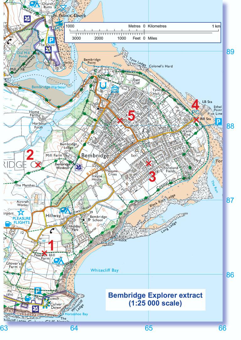
3 a. Have a look at the key on a 1: scale map and see if you can find out what these symbols mean. Ordnance Survey maps are always printed so that north is at the top of the sheet. A B C D E b. You can invent your own symbols for things on your own sketch map. Here are two ideas; can you guess what they are? A Get your friends and family to test you on how well you know the symbols. If you can learn them, then map reading is easy. 3. Which direction am I going? Just as it is important to know which is your left and your right hand, in map reading it is important to understand where north, east, south and west are. You can remember where the points of the compass are by using one of these rhymes: B Using the Bembridge Explorer extract on this leaflet can you answer these questions? a. Which general direction are you heading if you are walking from point 1 to point 2? b. Which general direction are you heading if you are walking from point 2 to point 3? c. Which general direction are you heading if you are walking from point 3 to point 1? 4. How do grid references help me to find places? You might have noticed by now that a 1: scale Ordnance Survey map is covered in a series of blue grid lines. These grid lines help you to pinpoint an exact location anywhere on the map by giving a unique number known as a grid reference. The vertical lines are called eastings, since they increase in value as you travel east on the map. The horizontal lines are called northings, since they increase in value as you travel north on the map. Four-figure grid references Naughty Elephants Squirt Water or Nobody Ever Swallows Whales If you are walking in a direction half way between two of the points of a compass, you can say you are heading north-east, south-east, south-west or north-west, depending on the direction. A four-figure grid reference is a handy way of identifying any square on a map. Grid references are easy if you can remember that you always have to go along the corridor before you go up the stairs. To find the number of a square first use the eastings to go along the corridor until you come to the bottom left-hand corner of the square you want. Write this two-figure number down. Then use the northing to go up the stairs until you find the same corner. Put this two-figure number after your first one and you now have the four-figure grid reference, which looks like this:


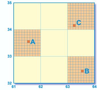
4 Always remember: Along the corridor and then up the stairs. a. Can you work out the four-figure grid references for the following examples? A... B... C... Now imagine this square is divided up into 100 tiny squares with 10 squares along each side. Still remembering to go along the corridor and up the stairs, work out the extra numbers you need and put them into your four-figure grid reference like this: Using the Bembridge Explorer extract on this leaflet, can you answer these questions? b. What is the name of the school in grid square 6486? c. What is the name of the named building in grid square 6488? d. What grid square is Black Rock found in? e. Can you work out the six-figure grid references for the following examples? A... B... C... Using the Bembridge Explorer extract on this leaflet can you answer these questions? Six-figure grid references If you want to pinpoint an exact place on a map, such as your own house, you will need to use a six-figure grid reference. First find the four-figure grid reference for the square and write it down with a space after each set of numbers, like this: f. What is at grid reference ? g. What would you be doing at grid reference ? h. What building is to be found at grid reference ? 62_ 33_ 4

.")

5 When giving directions you can provide even more accuracy to your grid reference by stating a nearby landmark or feature. For example, on the Bembridge Explorer extract I am at grid reference , at the crossroads. 5. What is scale? The scale of a map shows how much you would have to enlarge your map to get the actual size of the piece of land you are looking at. For example, your map has a scale of 1:25 000, which means that every 1 cm on the map represents of those same units of measurement on the ground (for example, cm = 250 metres). That might sound a bit complicated, but Ordnance Survey maps have been designed to make understanding scale easy. Look at the front of a 1: scale map and you will see that the scale has been written out for you like this: 4 cm to 1 km This means that every 4 cm on a map = 1 km in real life. To make it even easier, the grid lines are exactly 4 cm apart, so every square is 1 km by 1 km. Maps are made at different scales for different purposes. The 1: scale map is very useful for walking, but if you use it in a car you will quickly drive off the edge! On the other hand, maps at 1: scale (note the extra zero) show lots more land but in far less detail. Sound professional by saying the map scales like this: for 1: scale you say one to twenty-five thou for 1: scale you say one to two-fifty thou 1: scale extract 1: scale extract a. Is a 1: scale map useful for walking or driving? 6. How do we measure distance? It is always important to know how far you have to travel and how long it is going to take you. By measuring a distance on your map, you can work out how far that is in reality. You can measure this distance either in a straight line (as the crow flies) or following a winding route such as a country lane. To get this information from a map is very easy. Here is a way of doing it: You can measure between two points by using a piece of thin string. If you are measuring the distance in a straight line, then simply stretch the string between the two points. If you are following a road or track that is not straight, bend the string to follow the exact shape until you reach the second point. 5


6 7. How are hills and mountains shown on a map? The ability to understand the shape of the ground from a map is a useful skill to learn, particularly in mountainous landscapes. The height and shape of the ground is shown on 1: scale maps by brown contour lines. A contour is a line drawn on a map which joins points of equal height above sea level. For 1: scale maps the interval between contours is usually 5 metres, although in mountainous regions it may well be 10 metres. Measuring distance using string Now that you have a distance in centimetres marked on your string you can find out the real distance. You can do this in a couple of ways: By eye Place string against the scale bar on the map. This is usually at the foot of the map sheet. The above diagram shows the link between the shape of a hill and the contours representing it on a map. Another way of thinking about contour lines is as a tide mark left by the sea as the tide goes out, leaving a line every 5 metres. By measuring Measure your distance on your string with a ruler. Suppose your string is 10 cms long. You know that 4 cms = 1 km, so the answer is 2.5 kms. Have a go at measuring the distances in the questions below using the Bembridge Explorer extract on this leaflet. Remember contour numbering reads up hill in other words the top of the number is uphill and the bottom is downhill. Also remember the closer contour lines are together, the steeper the slope. The examples below illustrate this: Shallow slope a. How far is it in a straight line on the ground from point 1 to point 2? b. How far is it to walk along the road from point 4 (IRB Sta) to point 5 (PO)? c. Can you work out how long it would take you to walk both these distances? (Most people walk at 3 km per hour, so it will take 20 minutes to walk in a straight line across a 1 km grid square.) Remember that the grid lines on a 1: scale map are 1 km apart. A quick way of estimating distance is to count each square you cross in a straight line. If going diagonally the distance across the grid square is about 1½ km. 6 Steep slope Try this quick contour quiz using the Bembridge Explorer extract on this leaflet a. What type of slope is at the point where the parking symbol is on the map in grid square 6385? Is it a shallow slope or a steep slope? b. If you are walking from point 2 to point 5 in a straight line, is it uphill or downhill?
7 7

8 I hope you already enjoy using maps. You can use them in many ways to learn more about where you and your friends live and where you go to school. Using maps in school will help you with your geography, history, environmental science and citizenship classes. This leaflet will help you understand how to use maps, especially those at 1: scale. If you go to you will find lots more map facts, quizzes and games. I was given my first map when I was still at school and it became a cherished possession. I hope you get as much enjoyment out of using maps as I did when I was your age. Best wishes, Vanessa Lawrence Director General and Chief Executive Ordnance Survey To have fun with maps, visit Where you can check out the latest on: Our Favourite Places where you can discover the coolest places to go. Games test your skills at MapMan, interactive map jigsaws and much more. Competitions test your knowledge on map competitions to win some great prizes. Homework Help make your homework using maps fun with interactive games and exercises. Did You Know...? find out some great fascinating facts to impress your friends. Contact details Ordnance Survey Customer HelpLine Phone: Fax: Web site: enquiries@ordsvy.gov.uk This leaflet was produced in association with The Expedition Company Ltd. 2a. A. Railway station. B. Orchard. C. Camp site. D. Marsh, reeds or saltings. E. Viewpoint. 2b. A. Sport. B. Burger bar. 3a. North. 3b. East. 3c. South-west. 4a. A B C b. Bembridge School. 4c. East Cliff. 4d e. A B C f. School. 4g. Horse riding. 4h. Place of worship with spire, minaret or dome. 5a. Driving. 6a metres or 1.18 km. 6b metres or 1.25 km. 6c. Points 1 to 2 = 24 minutes approximately; points 4 to 5 = 25 minutes approximately. 7a. It is a steep slope. 7b. Uphill. 8 Answers to questions
Map reading made easy
 Map reading made easy 1. What is a map? A map is simply a drawing or picture (in 2-D) of a landscape or area of a country (in 3-D). It could be anything from a sketch map for a visitor to find your school
Map reading made easy
 Map reading made easy Maps can be great fun and they can lead you to all sorts of discoveries. They can help you get to know an area really well, because they pinpoint interesting places that are often
Map reading made easy
 Map reading made easy 1. What is a map? A map is simply a drawing or picture (in 2-D) of a landscape or area of a country (in 3-D). It could be anything from a sketch map for a visitor to find your school
MAP READING MADE EASY
 ORDNANCE SURVEY MAP READING MADE EASY 1 What is a map? A map is simply a drawing or picture (in 2D) of a landscape or area of a country (in 3D). It could be anything from a sketch map for a visitor to
What is a map? Understanding your map needs
 What is a map? A map is simply a drawing or picture of a landscape or location. Maps usually show the landscape as it would be seen from above, looking directly down. As well as showing the landscape of
Scout Skills Mapping QUALITY TRAINING FOR QUALITY SCOUTING INFORMATION SHEET
 Scout Skills Mapping INFORMATION SHEET A map is a picture of a given area of what the ground looks like from directly above. When undertaking a journey, we need to be able to find our way around competently,
BUSH NAV BUSH NAV DAY Navigation for Bush Navigation Day. November. WhitehorseD AY. Section 1 Registration, Maps & Checkpoints
 BUSH DAY Navigation for Bush Navigation Day Robert Kirwan, Nunawading SES W NW N NE E If you have little or no bush navigation experience then you will have been teamed up with members that have that experience
Navigating for Scouts A Self-teaching Guide to Navigation with Map and Compass
 Don Burgess, November 2003 Materials topographic maps Navigating for Scouts A Self-teaching Guide to Navigation with Map and Compass metric ruler orienteering compass 30 M/5 Hamilton-Burlington 41 I/13
Scout Skills Mapping INFORMATION SHEET. Town Maps
 Scout Skills Mapping 0845 300 1818 INFORMATION SHEET A map is a picture of a given area of what the ground looks like from directly above. When undertaking a journey, we need to be able to find our way
Using Map and Compass Together
 Using Map and Compass Together In situations where you foresee a potential evacuation on foot, where there are no roads, and no indication as to the direction of travel (i.e., road signs), it is recommended
YEAR 7 REVISION BOOKLET
 YEAR 7 REVISION BOOKLET Assessment checklist 1. To be able to define Geography. 2. Give examples of what we study in geography 3. Group what we study into the three major areas of geography 4. To be able
Map reading notes. It is a very useful kind of map that shows the topography of an area, i.e whether it is flat, undulating, rugged or mountainous
 Introduction Map reading notes In the course of 2 or 3 years course, Candidates will be exposed to topographical maps from tropical countries such as Mauritius, Tanzania, Zimbabwe and Jamaica. Many of
56H. This system allows definition of points on the Earth s surface to within 100 meters. Page 20. Navigation Systems Basics of Maps
 Grid References Many maps are provided with the standard grid overlaying them. This provides a simple and accurate method for finding features on the map. It is a network of intersecting parallel lines
ORIENTEERING. The challenge is to use the map to decide the best route to complete the course in the quickest time. Orienteering Map. Compass.
 ORIENTEERING Orienteering is similar to a cross-country race but you navigate using a map instead of following a set course. It is an outdoor sport where competitors navigate their own way, you can run,
Map reading. From the beginner to the advanced map reader
 Map reading From the beginner to the advanced map reader 1 Contents What is a map? 3 Understanding your map needs 3 Map symbols explained 4 Map scale: What it means 5 Understanding your map 1. The basics
Notes and Summary pages:
 Topographic Mapping 8.9C Interpret topographical maps and satellite views to identify land and erosional features and predict how these shapes may be reshaped by weathering ATL Skills: Communication taking
Topographic Maps. More than a Road Map
 Topographic Maps More than a Road Map What is a Topographic Map? Scaled representation of features on the surface of the Earth such as roads, rivers, and plains Provides information about land elevations
Navigation. A question. Take a map and remove the actual map and what are you left with?
 Map reading is part art and part skill. The art comes from practice and the skill from following a few simple rules. Here BGMA will take a step-by-step look at how to become a good (dare we say, skilled)
Erosional Features. What processes shaped this landscape?
 Have you ever looked at the land around you and wondered what processes shaped what you see? Perhaps you see mountains, valleys, rivers, or canyons. Do you know how long these geologic features have been
EROSIONAL FEATURES. reflect
 reflect Have you ever looked at the land around you and wondered what processes shaped what you see? Perhaps you see mountains, valleys, rivers, or canyons. Do you know how long these geologic features
NAME: DATE: Leaving Certificate GEOGRAPHY: Maps and aerial photographs. Maps and Aerial Photographs
 NAME: DATE: Leaving Certificate Geography Maps and Aerial Photographs Please see Teachers Notes for explanations, additional activities, and tips and suggestions. Learning Support Vocabulary, key terms
of places Key stage 1 Key stage 2 describe places
 Unit 25 Geography and numbers ABOUT THE UNIT This continuous unit aims to show how geographical enquiry can provide a meaningful context for the teaching and reinforcement of many aspects of the framework
iv vi x Using maps 2 Using images and analysing data 6 Using new technologies in geography 8
 Contents Exam board specification map Introduction Topic checker iv vi x Geographical skills Using maps 2 Using images and analysing data 6 Using new technologies in geography 8 Natural hazards Tectonic
Give 4 advantages of using ICT in the collection of data. Give. Give 4 disadvantages in the use of ICT in the collection of data
 Give 4 advantages of using ICT in the collection of data can use a handheld GPS to get accurate location information which can be used to show data linked to specific locations within a GIS can collect
Geology 101 Lab Worksheet: Topographic Maps
 Geology 101 Lab Worksheet: Topographic Maps Name: Refer to the Topographic Maps Lab for the information you need to complete this worksheet (http://commons.wvc.edu/rdawes/g101ocl/labs/topomapslab.html).
Mapping Earth. How are Earth s surface features measured and modeled?
 Name Mapping Earth How are Earth s surface features measured and modeled? Before You Read Before you read the chapter, think about what you know about maps Record your thoughts in the first column Pair
Analyzing Motion: Enrichment
 Chapter 2 Analyzing Motion: Enrichment Note to Teachers: The concepts involved in motion position, velocity, acceleration, and time should be developed using the four modes of representation: visual, numeric,
The Navigator s Dozen
 www.meadowsdofe.org.uk leaders@meadowsdofe.org.uk The Navigator s Dozen The 12 most important mountain navigation skills 1. Symbols and Grid References 1 2. Map scales and measuring distances 2 3. Setting
Geography Knowledge Organiser: What is a Geographer?
 Geography Knowledge Organiser: What is a Geographer? KPI 7.1.1 Locate and name the continents and oceans of the world, identify characteristics of the four countries and capital cities of the United Kingdom
3.3 Acceleration An example of acceleration Definition of acceleration Acceleration Figure 3.16: Steeper hills
 3.3 Acceleration Constant speed is easy to understand. However, almost nothing moves with constant speed for long. When the driver steps on the gas pedal, the speed of the car increases. When the driver
Topographic Map Series:
 DEFINITION OF A MAP A MAP IS A GEOGRAPHIC PREPRESENTATION OF A PORTION OF THE EARTH S SURFACE DRAWN TO SCALE, AS SEEN FROM ABOVE. IT S USES COLORS, SYMBOLS AND LABELS TO REPRESENT FEATURES FOUND ON THE
Compass Basics. Quick Map Basics Review For Compass Use
 Compass Basics Quick Map Basics Review For Compass Use A topographic map tells you where things are and how to get to them, whether you're hiking, biking, hunting, fishing, or just interested in the world
Basic navigation. Essentials. Maps. Contours. Hill. Ridge. scoutadventures.org.uk Adventures
 Basic navigation ssentials This sheet covers the basic techniques and information needed to navigate using a map and a compass. Maps A map is a two dimensional representation of an area of land, as if
Wednesday 8 June 2016 Afternoon
 Oxford Cambridge and RSA H Wednesday 8 June 2016 Afternoon GCSE GEOGRAPHY A A732/02 Geographical Skills (Higher Tier) *4410185572* Candidates answer on the Question Paper. OCR supplied materials: An Insert
***When doing the lab report write-up, be sure to follow the guidelines.***
 Topographic Maps Lab Vocabulary: topography - study of the shapes and features of the earth's surface elevation - height above sea level bench mark - a point that has been accurately measured for its position
UNIT 1C. USING TOPOGRAPHIC MAPS WHERE IN THE WORLD... ARE YOU?
 UNIT 1C. USING TOPOGRAPHIC MAPS WHERE IN THE WORLD... ARE YOU? TIME 60-90 minutes LEVEL All BENCHMARKS Next Generation Science Standards MS-LS1.D Science & Engineering Practices Developing and Using Models
Orienteering Maps & Map Reading Latitude and Longitude Scale
 Orienteering Maps & Map Reading A map is a two-dimensional representation of the three-dimensional world you'll be hiking in. All maps will have some basic features in common and map reading is all about
Position, Speed and Velocity Position is a variable that gives your location relative to an origin. The origin is the place where position equals 0.
 Position, Speed and Velocity Position is a variable that gives your location relative to an origin. The origin is the place where position equals 0. The position of this car at 50 cm describes where the
Subject: Geography Scheme of Work: B1 to B6 Mastery tiles. Term: Autumn/Spring/Summer
 Subject: Geography Scheme of Work: B1 to B6 Mastery tiles Term: Autumn/Spring/Summer Topic / Unit(s) Overview / Context Introduction to geography. An introduction to geography including basic map skills
HWA CHONG INSTITUTION NATIONAL POLICE CADET CORPS TOPOGRAPHY AND ORIENTEERING. Topography and Orienteering
 Topography and Orienteering 1. Introduction Orienteering is about using a topographic map and compass to find points in the landscape. It is fun and challenging, as one would need to take reference to
6-1 Slope. Objectives 1. find the slope of a line 2. use rate of change to solve problems
 6-1 Slope Objectives 1. find the slope of a line 2. use rate of change to solve problems What is the meaning of this sign? 1. Icy Road Ahead 2. Steep Road Ahead 3. Curvy Road Ahead 4. Trucks Entering Highway
PHYSICS Kinematics in One Dimension
 PHYSICS Kinematics in One Dimension August 13, 2012 www.njctl.org 1 Motion in One Dimension Return to Table of Contents 2 Distance We all know what the distance between two objects is... So what is it?
ORIENTEERING I.E.S. JUANA DE CASTILLA ORIENTEERING. 3rd E.S.O. SECOND TERM P.E. DEPARTMENT
 3rd E.S.O. SECOND TERM 1 Orientation is the set of systems that allows us to recognize at all times: The situation of the cardinal points The place where we are The direction to take to reach the desired
Earth and Space: Topographic Maps Satellite Images
 Earth and Space: Topographic Maps Satellite Images Earth and Space: Formative Assessment Activities for Earth and Space Topographic Maps Satellite Images Teacher Pages Purpose The purpose of this station
SCIENCE 1206 Unit 3. Physical Science Motion
 SCIENCE 1206 Unit 3 Physical Science Motion Section 1: Units, Measurements and Error What is Physics? Physics is the study of motion, matter, energy, and force. Qualitative and Quantitative Descriptions
Basic Map Skills for the Outdoors
 Geography 80-20 80% of what there is to know, for 20% of the sweat Basic Map Skills for the Outdoors Map Scale Map source: US Geological Survey Four ways to indicate map scale: Representative fraction
Laboratory Exercise #2 Introduction to Quadrangle Maps
 page - Laboratory Exercise #2 Introduction to Quadrangle Maps A. Introduction to Quadrangle Maps The United States Geological Survey has developed a nationwide series of quadrangle maps that cover small
name and locate the world s seven continents and five oceans
 Subject: Geography Activities National Curriculum Objectives One Progression of Skills Name the 7 continents and 5 oceans 3D Jigsaw task to locate continents and seas name and locate the world s seven
Preliminary Physics. Moving About. DUXCollege. Week 2. Student name:. Class code:.. Teacher name:.
 Week 2 Student name:. Class code:.. Teacher name:. DUXCollege Week 2 Theory 1 Present information graphically of: o Displacement vs time o Velocity vs time for objects with uniform and non-uniform linear
Introduction to Contour Maps
 Your web browser (Safari 7) is out of date. For more security, comfort and Activityengage the best experience on this site: Update your browser Ignore Introduction to Contour Maps What information does
About places and/or important events Landmarks Maps How the land is, hills or flat or mountain range Connected to maps World Different countries
 What do you think you know about geography? About places and/or important events Landmarks Maps How the land is, hills or flat or mountain range Connected to maps World Different countries What do you
Displacement and Velocity
 2.2 Displacement and Velocity In the last section, you saw how diagrams allow you to describe motion qualitatively. It is not at all difficult to determine whether an object or person is at rest, speeding
Map Reading & Compass Use
 Spring 2013 Kestrel Land Trust Page 2 / 10 Contents Map Basics... 3 Map Types... 3 Terrain Association... 4 Estimating Distance: Pacing... 4 Contour Lines... 5 Navigating with a Compass... 6 Compass Types...
Landmarks Paula Owens 5 7 years
 Landmarks Paula Owens Geography teaching resource 5 7 years This is one of a series of teaching resources for use with Digimap for Schools. For more details about this service, visit http://digimapforschools.edina.ac.uk
Chapter 2 Describing Motion
 Chapter 2 Describing Motion Chapter 2 Overview In chapter 2, we will try to accomplish two primary goals. 1. Understand and describe the motion of objects. Define concepts like speed, velocity, acceleration,
Where, on Earth, are you?
 Where, on Earth, are you? We all live on a big planet called Earth, of course. But where on Earth? And if you want to go to a different spot on Earth other than the spot you are in, how do you know which
Lesson 2 DRAWING A SIMPLE MAP WALT: Draw a simple map. Lesson 3 DRAWING A MAP TO SCALE. scale map.
 Year 3 GEOGRAPHY Mapping Lesson 1 WHAT MAPS SHOW US WALT: Describe the purpose of a map. Lesson 2 DRAWING A SIMPLE MAP WALT: Draw a simple map. Lesson 3 DRAWING A MAP TO SCALE WALT: Draw a simple scale
REVISION: MAPWORK 18 SEPTEMBER 2014
 REVISION: MAPWORK 18 SEPTEMBER 2014 Lesson Description In this lesson we revise: Various mapwork calculations Summary Relative Position Bearing is the angular (angle) distance between two points True Bearing
Avalon Marshes Landscape
 Avalon Marshes Landscape Mapping the Marshes KS2 & KS3 Outline The Avalon Marshes is a unique and interesting landscape and this set of resources is designed to help Description pupils interact with the
Sheaf Valley Maths Trail
 Sheaf Valley Maths Trail You need to be in a team of 3 or 4 people. Each team will need a DIY tape measure, a ball of string, a board protractor, a pencil and a calculator. It is very important you stay
VCE PHYSICS. Brian Shadwick. Unit 2 What Do Experiments Reveal. About the Physical World?
 2 Unit 2 What Do Experiments Reveal About the Physical World? VCE PHYSICS Brian Shadwick 2016 Bag 7023 Marrickville SW 1475 Australia Tel: (02) 9516 1122 Fax: (02) 9550 1915 sales@sciencepress.com.au www.sciencepress.com.au
(Hint: You must always back up map work questions with evidence from the map e.g. grid references.)
") Map Work Revision Notes (Hint: You must always back up map work questions with evidence from the map e.g. grid references.) Scale Scale is the ratio between a distance on a map and the corresponding distance
Map Work Revision Notes (Hint: You must always back up map work questions with evidence from the map e.g. grid references.) Scale Scale is the ratio between a distance on a map and the corresponding distance
MAPWORK PRACTICE EXERCISES 13+ ABERDEEN
 Independent Schools Examinations Board MAPWORK PRACTICE EXERCISES 13+ ABERDEEN Belinda Froud-Yannic Independent Schools Examinations Board www.galorepark.co.uk Published by ISEB Publications, an imprint
Koenji. Using ARCGIS Online to explore a place
 Koenji Using ARCGIS Online to explore a place ArcGIS Online is a GIS program that can be opened at http://www.arcgis.com/home/ You can click on Sign-up now or Make a map to get started. It is free to use
AS 410 Land Navigation. Chpt 4-1
 AS 410 Land Navigation Chpt 4-1 Overview Types of Maps Map Legends / Scales Latitude and Longitude Orienteering Why? Why important to learn how to read a compass and map? No cell phone coverage Mountain
Earth Science Regents Reading Topographic Maps
 Earth Science Regents Reading Topographic Maps Name Period Quick Tutorial on Degrees, Minutes, and Seconds of Latitude and Longitude A degree of latitude on the surface of the earth is about 70 miles long.
Math Fundamentals for Statistics I (Math 52) Unit 7: Connections (Graphs, Equations and Inequalities)
 Unit 7: Connections (Graphs, Equations and Inequalities)") Math Fundamentals for Statistics I (Math 52) Unit 7: Connections (Graphs, Equations and Inequalities) By Scott Fallstrom and Brent Pickett The How and Whys Guys This work is licensed under a Creative Commons
Math Fundamentals for Statistics I (Math 52) Unit 7: Connections (Graphs, Equations and Inequalities) By Scott Fallstrom and Brent Pickett The How and Whys Guys This work is licensed under a Creative Commons
WEEK 7 NOTES AND EXERCISES
 WEEK 7 NOTES AND EXERCISES RATES OF CHANGE (STRAIGHT LINES) Rates of change are very important in mathematics. Take for example the speed of a car. It is a measure of how far the car travels over a certain
Appearances Can Be Deceiving!
 Appearances Can Be Deceiving! Overview: Students explore the relationship between angular width, actual size, and distance by using their finger, thumb and fist as a unit of angular measurement in this
THE MOVING MAN: DISTANCE, DISPLACEMENT, SPEED & VELOCITY
 THE MOVING MAN: DISTANCE, DISPLACEMENT, SPEED & VELOCITY Background Remember graphs are not just an evil thing your teacher makes you create, they are a means of communication. Graphs are a way of communicating
Map Makers 2nd Grade
 Map Makers 2nd Grade Students use mapmaking to develop science and social studies concepts and practice map skills while developing a sense of place and a connection to the property. Concepts of landforms,
Mathematics Second Practice Test 1 Levels 6-8 Calculator not allowed
 Mathematics Second Practice Test 1 Levels 6-8 Calculator not allowed Please read this page, but do not open your booklet until your teacher tells you to start. Write your name and the name of your school
Grade 6 Math Circles October 9 & Visual Vectors
 Faculty of Mathematics Waterloo, Ontario N2L 3G1 Centre for Education in Mathematics and Computing Grade 6 Math Circles October 9 & 10 2018 Visual Vectors Introduction What is a vector? How does it differ
Ebook Code: REAU1124. Developing English Skills Through Themes
 Ebook Code: REAU1124 Developing English Skills Through Themes Contents Teachers Notes 4 Curriculum Links 5 Antarctica 6 Activity Sheets 7-11 Dinosaurs 12 Activity Sheets 13-17 Natural Disasters 18 Activity
Witchampton CofE First School Geography Curriculum Map
 2016-2017 Autumn People and : 30-50 Show interest in the lives of people who are familiar to them. Shows interest in different occupations. Remembers and talks significant events in their own experience.
In order to be adequately prepared for a test on this topic you should be able to:-
 Topic 2: MAPPING In order to be adequately prepared for a test on this topic you should be able to:- 1. Find and also provide both FOUR and SIX figure Area and Grid References 2. Calculate distances both
Applications of Mathematics
 Write your name here Surname Other names Edexcel GCSE Centre Number Candidate Number Applications of Mathematics Unit 2: Applications 2 For Approved Pilot Centres ONLY Higher Tier Friday 14 June 2013 Morning
Map Skills Lesson 1. Materials: maps, pencils, Lesson 1 Worksheet, strips of paper, grid paper
 Map Skills Lesson 1 Use cardinal directions, map grids, scales, and titles to locate places on a map. Interpret a map using information from its title, compass rose, scale, and legend. Vocabulary: map,
YEAR 7 GEOGRAPHY KNOWLEDGE BOOK
 YEAR 7 GEOGRAPHY KNOWLEDGE BOOK 1 P a g e WEATHER & CLIMATE The information here is what all students MUST know. Use this sheet as a checklist to identify what is clear to you, what you need to work on,
chapter Are you going somewhere in the next few days? Using Geographical Information COPYRIGHTED MATERIAL in this chapter Understanding Your Location
 Using Geographical Information Are you going somewhere in the next few days? Have you thought about how you are going to get there? Have you thought about what might be there when you arrive? Geographical
GRADE 6 GEOGRAPHY TERM 1 LATITUDE AND LONGITUDE (degrees)
") 1 GRADE 6 GEOGRAPHY TERM 1 LATITUDE AND LONGITUDE (degrees) Contents Lines of Latitude... 2 Lines of Longitude... 3 The hemispheres of The Earth... 4 Finding countries and cities on a map using latitude
1 GRADE 6 GEOGRAPHY TERM 1 LATITUDE AND LONGITUDE (degrees) Contents Lines of Latitude... 2 Lines of Longitude... 3 The hemispheres of The Earth... 4 Finding countries and cities on a map using latitude
Lesson 7: Slopes and Functions: Speed and Velocity
 Lesson 7: Slopes and Functions: Speed and Velocity 7.1 Observe and Represent Another way of comparing trend lines is by calculating the slope of each line and comparing the numerical values of the slopes.
APPENDIX A GLOSSARY. Appendix A.1
 APPENDIX A GLOSSARY Appendix A.1 Appendix A.2 Back Bearing A back bearing is measured from the object to your position. It is the exact opposite of a direct bearing. Base Line An imaginary line on the
Copyright, Nick E. Nolfi MPM1D9 Unit 6 Statistics (Data Analysis) STA-1
 STA-1") UNIT 6 STATISTICS (DATA ANALYSIS) UNIT 6 STATISTICS (DATA ANALYSIS)... 1 INTRODUCTION TO STATISTICS... 2 UNDERSTANDING STATISTICS REQUIRES A CHANGE IN MINDSET... 2 UNDERSTANDING SCATTER PLOTS #1... 3 UNDERSTANDING
UNIT 6 STATISTICS (DATA ANALYSIS) UNIT 6 STATISTICS (DATA ANALYSIS)... 1 INTRODUCTION TO STATISTICS... 2 UNDERSTANDING STATISTICS REQUIRES A CHANGE IN MINDSET... 2 UNDERSTANDING SCATTER PLOTS #1... 3 UNDERSTANDING
Red Star Navigation. Bearings:
 Red Star Navigation Bearings: The main focus in Red Star Navigation is how to use a compass and in particular compass bearings. It is important for cadets to describe bearings as this will assist them
Grade 6 Math Circles October 9 & Visual Vectors
 Faculty of Mathematics Waterloo, Ontario N2L 3G1 Centre for Education in Mathematics and Computing Grade 6 Math Circles October 9 & 10 2018 Visual Vectors Introduction What is a vector? How does it differ
Latitude and Longitude, Plus Map Scale
 Name Lab 4 More Date: Latitude and Longitude, Plus Map Scale In the first few labs of the semester, you found that you needed to look at a variety of maps to answer all the questions. One reason you needed
Map and Compass Skills
 Map and Compass Skills Grade levels: 5-12 In a Nutshell Given a map and compass, students will be able to find a location on the map, chart a course to that location with the compass, and find that location
STAAR Science Tutorial 40 TEK 8.9C: Topographic Maps & Erosional Landforms
 Name: Teacher: Pd. Date: STAAR Science Tutorial 40 TEK 8.9C: Topographic Maps & Erosional Landforms TEK 8.9C: Interpret topographic maps and satellite views to identify land and erosional features and
Regents Earth Science Unit 1 Earth Dimensions
 Regents Earth Science Unit 1 Earth Dimensions www. BarnesWeb.org 2014-15 edition Name: Name: OBJECTIVES Correctly define: isolines, gradient, topographic map, contour interval, hachured lines, profile,
Student Instruction Sheet: Unit 3, Lesson 3. Solving Quadratic Relations
 Student Instruction Sheet: Unit 3, Lesson 3 Solving Quadratic Relations Suggested Time: 75 minutes What s important in this lesson: In this lesson, you will learn how to solve a variety of quadratic relations.
Fantasy Maps. Geography teaching resource. Paula Owens. Primary. Imaginary mapping: features and keys
 Fantasy Maps Imaginary mapping: features and keys Paula Owens Geography teaching resource Primary Digimap for Schools Geography Resources Title: Fantasy maps Level Context Location Secondary Imaginary
Picture Detectives. Geography teaching resource
 Picture Detectives Matching images and clues to map references Paula Owens Geography teaching resource Primary Digimap for Schools Geography Resources These resources are a guide for teachers to demonstrate
Laboratory Exercise #2 Introduction to Quadrangle Maps
 page - 1 Laboratory Exercise #2 Introduction to Quadrangle Maps A. Introduction to Quadrangle Maps The United States Geological Survey has developed a nationwide series of quadrangle maps that cover small
Relative and Absolute Directions
 Relative and Absolute Directions Purpose Learning about latitude and longitude Developing math skills Overview Students begin by asking the simple question: Where Am I? Then they learn about the magnetic
Q25: Record the wavelength of each colored line according to the scale given.
 C. Measurement Errors and Uncertainties The term "error" signifies a deviation of the result from some "true" value. Often in science, we cannot know what the true value is, and we can only determine estimates
Remote Sensing/Reflectance Spectrometer
 Remote Sensing/Reflectance Spectrometer REMOTE SENSING / REFLECTANCE SPECTROMETER TEACHER NOTES The remote sensing experiment is designed to take a full hour to complete, and can be undertaken using just
LET S GO ON A ROAD TRIP
 Partner School News June 2016 In this issue: Education Children Around the World www.opportunityeducation.org Road Trip Start Writing Right Now Teaching Tip of the Month Focus on Schools LET S GO ON A