Using GIS to Brief New York City Public Officials after September 11
|
|
|
- Charleen Rogers
- 5 years ago
- Views:
Transcription
1 Using GIS to Brief New York City Public Officials after September 11 Presented by Zvia Segal Naphtali, Ph.D. and Leonard M. Naphtali, Ph.D. Presented at the ESRI International Health GIS Conference, May 6, 2003
2 Zvia Segal Naphtali is an Adjunct Assistant Professor Robert F. Wagner Graduate School of Public Service, New York University and the President of Resource Mobilization Inc. Leonard M. Naphtali, is the Vice President of Resource Mobilization Inc. 575 West End Avenue New York, NY Tel: ; FAX: s
3 Abstract In a February 2002 briefing, GIS was used to acquaint New York City public officials with demographic and health conditions and the location of health and other facilities in their districts. Purpose: To show how GIS plays a critical role in making informed decisions in routine as well as high risk situations and in collaboration between agencies (elected officials, health, police, fire) in post September 11. Method: The paper includes maps of key demographic and health indicators (AIDS, tuberculosis, asthma, infant mortality, etc.), the location of hospitals and ambulatory care sites, TRI sites, fire houses, police stations and schools in New York City. On each of these maps, the boundaries of the City Council districts are superimposed over the ZIP Code data. Results: A Map Book containing over 100 maps designed for post September 11 New York City. Conclusion: GIS technology can help with evidence-based decision making especially in disaster and bio-terrorism preparedness planning.
4 GIS saves lives September 11 highlighted the power of GIS September 11 demonstrated to people, both inside and outside the GIS community, that GIS can play a critical role in making informed decisions in routine as well as in high risk situations. The New York City GIS community recognized that the timely availability of data, and data compatibility among different sources, are critical especially in high risk situations. The New York City GIS community learned about the critical importance of collaboration between agencies.
5 The New York City GIS community also learned about the vulnerability to data loss Suddenly starting from scratch The Emergency Mapping and Data Center at Pier 92 Read about it at the following web site winter0102articles/nyc-creating.html creating.html
6 Moving from response and recovery efforts to community preparedness planning and risk assessment

7 Using GIS in a Health Briefing for New York City Public Officials February 8, 2002 New York University
8 Our paper describes an effort to promote community preparedness planning. A Map Book was prepared for newly elected officials including demographic and health characteristics of neighborhoods in New York City, and the location of facilities -- hospitals and ambulatory care facilities, fire, police, schools, etc., --in their districts.

9 Two months after September 11, (on November 8, 2001), an election was held for a new Mayor and the New York City Council. Because of term limits a large number of the City Council members were serving in this office for the first time, starting January 2002.
10 The first speaker at the briefing was Dr. Thomas R. Frieden, Commissioner of the NYC Department of Health How Healthy is New York City? Dr. Frieden also discussed briefly the status Bioterrorism Preparedness in New York City -- Early detection of anthrax; Response to alarms; Mass public health interventions and the coordination of activities with partners.
11 Bioterrorism and Public Health Preparedness was addressed in other presentations. Dr. Joel Ackelsberg discussed the Department s health surveillance plans, focusing on anthrax and smallpox, and the availability of vaccines. Dr. Joel Ackelsberg is the Medical Director of the Emergency Readiness and Response Unit of NYC s Department of Health.

12 Selected maps from a Map Book prepared for the Health Briefing for Public Officials
13 Health Briefing for Newly Elected Public Officials
14 Health Briefing for Newly Elected Public Officials
15 Health Briefing for Newly Elected Public Officials
16 Health Briefing for Newly Elected Public Officials

17 POPULATION DENSITY AND CITY COUNCIL DISTRICTS Brooklyn, New York City

18 PERCENT HISPANIC OR LATINO & CITY COUNCIL DISTRICTS Brooklyn, NYC

19 PERCENT NON-HISPANIC WHITE & CITY COUNCIL DISTRICTS Brooklyn, NYC

20 PERCENT NON-HISPANIC BLACK & CITY COUNCIL DISTRICTS Brooklyn, NYC

21 PERCENT NON-HISPANIC ASIAN & CITY COUNCIL DISTRICTS Brooklyn, NYC

22 PERCENT OF HOUSEHOLDS with Low Income Brooklyn, NYC

23 ASTHMA HOSPITALIZATION RATE PER 100,000

24 PERSONS LIVING WITH AIDS PER 100,000 POPULATION

25 TUBERCULOSIS CASES Brooklyn, New York City

26 INFANT MORTALITY Per 1,000 Live Births Brooklyn, New York City

27 BREAST CANCER A PUZZLE?
28 Breast Cancer Incidence versus Expected Incidence means the number of newly diagnosed cases of Breast Cancer The cancer rate for the entire state and the number of women in each age group are used to calculate the number of women who would be expected to get this type of cancer. csii/nyscsii.htm
29 MAPPING FACILITIES Schools Firehouses Hospitals Police stations Ambulatory Care Facilities and also the location of TRI (Toxic Release Inventory) sites.
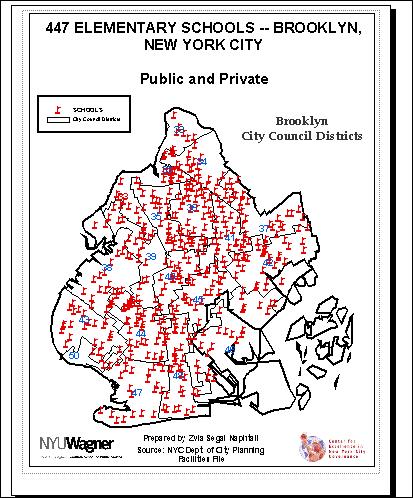
30 ELEMENTARY SCHOOLS

31 Firehouses in Brooklyn
32 Hospitals In Brooklyn
33 Using GIS to simulate emergency response

34 Imagine that a truck carrying a large bomb exploded in central Brooklyn, New York City.
35 The bomb exploded in a densely populated area and in close proximity to several schools. This is an emergency that can test the ability of GIS to provide information rapidly to the medical facilities in the surrounding area, to the police and fire departments.

36 Facilities and the Site of the Bomb
37 With the Map Book at hand a Councilperson will be better prepared to collaborate with other agencies in the affected area as they gather information on the schools, hospitals, police stations, and firehouses in the immediate vicinity.

38 The Site of the Bomb: A Closer look

39 A Closer Look

40 15 Schools are within.25,.5 and.75 miles of the bomb Several of the hospitals are one or more miles away north and south of the affected area Parts of City Council Districts 39, 40 and 45 are within the affected area
41 To conclude, GIS technology can help with evidence-based decision making especially in disaster preparedness planning.
Applying Health Outcome Data to Improve Health Equity
 Applying Health Outcome Data to Improve Health Equity Devon Williford, MPH, Health GIS Specialist Lorraine Dixon-Jones, Policy Analyst CDPHE Health Equity and Environmental Justice Collaborative Mile High
Oregon Population Forecast Program
 Oregon Population Forecast Program Regional Forecast Meeting October 2, 2015 Presentation by Population Forecast Program Team Hood River County Oregon Population Forecast Program Project Team Xiaomin Ruan,
Medical GIS: New Uses of Mapping Technology in Public Health. Peter Hayward, PhD Department of Geography SUNY College at Oneonta
 Medical GIS: New Uses of Mapping Technology in Public Health Peter Hayward, PhD Department of Geography SUNY College at Oneonta Invited research seminar presentation at Bassett Healthcare. Cooperstown,
Crime Analysis. GIS Solutions for Intelligence-Led Policing
 Crime Analysis GIS Solutions for Intelligence-Led Policing Applying GIS Technology to Crime Analysis Know Your Community Analyze Your Crime Use Your Advantage GIS aids crime analysis by Identifying and
John Laznik 273 Delaplane Ave Newark, DE (302)
") Office Address: John Laznik 273 Delaplane Ave Newark, DE 19711 (302) 831-0479 Center for Applied Demography and Survey Research College of Human Services, Education and Public Policy University of Delaware
Office Address: John Laznik 273 Delaplane Ave Newark, DE 19711 (302) 831-0479 Center for Applied Demography and Survey Research College of Human Services, Education and Public Policy University of Delaware
Geographic Systems and Analysis
 Geographic Systems and Analysis New York University Robert F. Wagner Graduate School of Public Service Instructor Stephanie Rosoff Contact: stephanie.rosoff@nyu.edu Office hours: Mondays by appointment
Finding Common Ground Through GIS
 Finding Common Ground Through GIS Matthew Stone, MPH Special Unit for Technical Assistance Chronic Disease and Injury Control California Department of Public Health ESRI Health GIS Conference Scottsdale,
The Use of Geographic Information Systems (GIS) by Local Governments. Giving municipal decision-makers the power to make better decisions
 by Local Governments. Giving municipal decision-makers the power to make better decisions") The Use of Geographic Information Systems (GIS) by Local Governments Giving municipal decision-makers the power to make better decisions Case Study: Examples of GIS Usage by Local Governments in North
The Use of Geographic Information Systems (GIS) by Local Governments Giving municipal decision-makers the power to make better decisions Case Study: Examples of GIS Usage by Local Governments in North
Report of the Working Group 2 Data Sharing and Integration for Disaster Management *
 UNITED NATIONS E/CONF.104/6 ECONOMIC AND SOCIAL COUNCIL Twentieth United Nations Regional Cartographic Conference for Asia and the Pacific Jeju, 6-9 October 2015 Item 5 of the provisional agenda Report
Extreme Temperature Protocol in Middlesex-London
 Clean Air Partnership Webinar March 17, 2009 Extreme Temperature Protocol in Middlesex-London Presented by Iqbal Kalsi, MBA, CPHI(C), CCEP iqbal.kalsi@mlhu.on.ca 1 History Informal monitoring, tracking
Everything is related to everything else, but near things are more related than distant things.
 SPATIAL ANALYSIS DR. TRIS ERYANDO, MA Everything is related to everything else, but near things are more related than distant things. (attributed to Tobler) WHAT IS SPATIAL DATA? 4 main types event data,
The Tampa Bay Catastrophic Plan Presentation to CFGIS Users Group FDOT District 5 Urban Offices - Orlando July 30, 2010
 The Tampa Bay Catastrophic Plan Presentation to CFGIS Users Group FDOT District 5 Urban Offices - Orlando July 30, 2010 Brady Smith Senior Planner Tampa Bay Regional Planning Council Introduction Recent
STAFF REPORT ACTION REQUIRED. Extreme Cold Weather Alerts in Toronto SUMMARY. Date: April 13, Board of Health. To: Medical Officer of Health
 HL3.6 STAFF REPORT ACTION REQUIRED Extreme Cold Weather Alerts in Toronto Date: April 13, 2015 To: From: Wards: Board of Health Medical Officer of Health All Reference Number: SUMMARY Cold weather can
Hurricane Readiness for Coastal Communities
 Hurricane Readiness for Participant Guide Developed for: Federal Emergency Management Agency Emergency Management Institute 16825 South Seton Avenue Emmitsburg, MD 21727-8998 Developed by: C² Technologies,
A HURRICANE IS COMING. Presented by Atiba Upchurch Broward Emergency Management Division
 A HURRICANE IS COMING Presented by Atiba Upchurch Broward Emergency Management Division Mission Statement To safeguard the lives and property of the people of Broward County from major hazards and emergencies
Implications for the Sharing Economy
 Locational Big Data and Analytics: Implications for the Sharing Economy AMCIS 2017 SIGGIS Workshop Brian N. Hilton, Ph.D. Associate Professor Director, Advanced GIS Lab Center for Information Systems and
Defining Statistically Significant Spatial Clusters of a Target Population using a Patient-Centered Approach within a GIS
 Defining Statistically Significant Spatial Clusters of a Target Population using a Patient-Centered Approach within a GIS Efforts to Improve Quality of Care Stephen Jones, PhD Bio-statistical Research
By Abdulraheem M.Baabbad. Supervisor: Dr.Bager Al-Ramadan
 By Abdulraheem M.Baabbad Supervisor: Dr.Bager Al-Ramadan OUTLINE Health GIS Health GIS Application Emergency Vehicles Allocation: A case study Health GIS Innovative structureto access,integrate,visualize
Purpose Study conducted to determine the needs of the health care workforce related to GIS use, incorporation and training.
 GIS and Health Care: Educational Needs Assessment Cindy Gotz, MPH, CHES Janice Frates, Ph.D. Suzanne Wechsler, Ph.D. Departments of Health Care Administration & Geography California State University Long
How Usable are Current GIS Maps?: Communicating Emergency Preparedness to Urban Populations
 How Usable are Current GIS Maps?: Communicating Emergency Preparedness to Urban Populations Christina Zarcadoolas PhD, Jennefer Boyer MPH, Arthi Krishnaswami MA, Andrea Rothenberg, MS, LCSW Mount Sinai
Hot Weather Response Plan
 City of Greater Sudbury Hot Weather Response Plan For Public Release Version 1.3 July 2007 May 2009 Revised: May 2010 TABLE OF CONTENTS Introduction... 3 Essential Components... 4 Objectives... 4 Roles
Measuring community health outcomes: New approaches for public health services research
 Research Brief March 2015 Measuring community health outcomes: New approaches for public health services research P ublic Health agencies are increasingly asked to do more with less. Tough economic times
APPLICATIONS OF EARTHQUAKE HAZARD MAPS TO LAND-USE AND EMERGENCY PLANNING EXAMPLES FROM THE PORTLAND AREA
 APPLICATIONS OF EARTHQUAKE HAZARD MAPS TO LAND-USE AND EMERGENCY PLANNING EXAMPLES FROM THE PORTLAND AREA O. Gerald Uba Metro, Portland, Oregon OVERVIEW The extent to which we understand "below ground"
MAKING PLANNING LOCAL
 Georgia Social Vulnerability Index 2010 Atlas MAKING PLANNING LOCAL VULNERABLE & AT-RISK POPULATIONS DATA FOR JURISDICTIONS AT THE CENSUS TRACT LEVEL Public Health Districts Regional Coordinating Hospital
Understanding China Census Data with GIS By Shuming Bao and Susan Haynie China Data Center, University of Michigan
 Understanding China Census Data with GIS By Shuming Bao and Susan Haynie China Data Center, University of Michigan The Census data for China provides comprehensive demographic and business information
Geomapping Drive-Time Based Market Areas for DoD TRICARE Beneficiaries
 Geomapping Drive-Time Based Market Areas for DoD TRICARE Beneficiaries Richard R. Bannick, Ph.D. and Tyler Erickson, Ph. D.* Accompanied in the audience by James Laramie* & Amii Kress Oct 25, 2006 Office
CCSG Needs Assessment: Characterizing the cancer burden in our catchment area
 CCSG Needs Assessment: Characterizing the cancer burden in our catchment area Jason A. Mendoza, MD, MPH Associate Director of Minority Health and Health Disparities Pilot Grant on Catchment Area Health
Hayward, P. (2007). Mexican-American assimilation in U.S. metropolitan areas. The Pennsylvania Geographer, 45(1), 3-15.
. Mexican-American assimilation in U.S. metropolitan areas. The Pennsylvania Geographer, 45(1), 3-15.") PETER HAYWARD Assistant Professor of Geography and GIS Faculty Fellow SUNY College at Oneonta 323 Milne Library Oneonta, NY 13820 Phone: 607-436-3398 Email: haywarpm@oneonta.edu Web: http://employees.oneonta.edu/haywarpm
PETER HAYWARD Assistant Professor of Geography and GIS Faculty Fellow SUNY College at Oneonta 323 Milne Library Oneonta, NY 13820 Phone: 607-436-3398 Email: haywarpm@oneonta.edu Web: http://employees.oneonta.edu/haywarpm
Geospatial Technologies for Resources Planning & Management
 Geospatial Technologies for Resources Planning & Management Lal Samarakoon, PhD Director, Geoinformatics Center Asian Institute of Technology, Thailand Content Geoinformatics for SDG Information Integration
Mapping and Health Equity Advocacy
 Mapping and Health Equity Advocacy Sarah Treuhaft PolicyLink November 7, 2008 About us PolicyLink National research and action institute that advances policies to achieve economic and social equity Center
Red Hook Recovery Project. Hurricane Sandy An Urban Disaster
 Red Hook Recovery Project Hurricane Sandy An Urban Disaster Overview Impact of Changing weather Urban Preparedness Overview of preparedness efforts Complexities of urban planning (Ex. NYC) Understanding
Community Inclusion in Colorado
 A Mapping Project for Emergency Preparedness and Response Aimee Voth Siebert, MA Julia Beems, MA Rachel Coles, MA Devon Williford, MPH Adam Anderson, MURP, MPH March 2015 understanding that HUMAN ENERGY
Winter Ready DC District of Columbia Public Service Commission
 Winter Ready DC District of Columbia Public Service Commission Presented by: Michael Poncia, Vice President, Customer Operations, Pepco Holdings October 26, 2017 Preparing our System Improving our system
Reducing Vulnerability to Extreme Heat: Science-Policy Interface
 Reducing Vulnerability to Extreme Heat: Science-Policy Interface Olga Wilhelmi, Mary Hayden, Jennifer Boehnert, Ursula Lauper and SIMMER research team October 23, 2013 Toronto SIMMER workshop Science-Policy
Emergency and Humanitarian Action (EHA), WHO Indonesia. Tornado, Serang, Banten Province, Republic of Indonesia and several parts of Indonesia
, WHO Indonesia. Tornado, Serang, Banten Province, Republic of Indonesia and several parts of Indonesia") Emergency and Humanitarian Action (EHA), WHO Indonesia Tornado, Serang, Banten Province, Republic of Indonesia and several parts of Indonesia HIGHLIGHTS On 29 January 2012 at 14.30 PM, tornado affected
Emergency and Humanitarian Action (EHA), WHO Indonesia Tornado, Serang, Banten Province, Republic of Indonesia and several parts of Indonesia HIGHLIGHTS On 29 January 2012 at 14.30 PM, tornado affected
Are You Maximizing The Value Of All Your Data?
 Are You Maximizing The Value Of All Your Data? Using The SAS Bridge for ESRI With ArcGIS Business Analyst In A Retail Market Analysis SAS and ESRI: Bringing GIS Mapping and SAS Data Together Presented
Geospatial natural disaster management
 Geospatial natural disaster management disasters happen. are you ready? Natural disasters can strike almost anywhere at any time, with no regard to a municipality s financial resources. These extraordinarily
County Public Health Department. A practical guide, lessons learned and current projects in a small local health department
 Integrating ti GIS into the El Dorado County Public Health Department y p A practical guide, lessons learned and current projects in a small local health department Presentation Overview How we got GIS
An online data and consulting resource of THE UNIVERSITY OF TOLEDO THE JACK FORD URBAN AFFAIRS CENTER
 An online data and consulting resource of THE JACK FORD URBAN AFFAIRS CENTER THE CENTER FOR GEOGRAPHIC INFORMATION SCIENCE AND APPLIED GEOGRAPHICS DEPARTMENT OF GEOGRAPHY AND PLANNING THE UNIVERSITY OF
Georeferencing and Satellite Image Support: Lessons learned, Challenges and Opportunities
 Georeferencing and Satellite Image Support: Lessons learned, Challenges and Opportunities Shirish Ravan shirish.ravan@unoosa.org UN-SPIDER United Nations Office for Outer Space Affairs (UNOOSA) UN-SPIDER
THE 3D SIMULATION INFORMATION SYSTEM FOR ASSESSING THE FLOODING LOST IN KEELUNG RIVER BASIN
 THE 3D SIMULATION INFORMATION SYSTEM FOR ASSESSING THE FLOODING LOST IN KEELUNG RIVER BASIN Kuo-Chung Wen *, Tsung-Hsing Huang ** * Associate Professor, Chinese Culture University, Taipei **Master, Chinese
Acknowledgments xiii Preface xv. GIS Tutorial 1 Introducing GIS and health applications 1. What is GIS? 2
 Acknowledgments xiii Preface xv GIS Tutorial 1 Introducing GIS and health applications 1 What is GIS? 2 Spatial data 2 Digital map infrastructure 4 Unique capabilities of GIS 5 Installing ArcView and the
NEW YORK DEPARTMENT OF SANITATION. Spatial Analysis of Complaints
 NEW YORK DEPARTMENT OF SANITATION Spatial Analysis of Complaints Spatial Information Design Lab Columbia University Graduate School of Architecture, Planning and Preservation November 2007 Title New York
Table-Top Exercise for Emergency Preparedness Evaluation: Little Anse, Isle Madame
 Table-Top Exercise for Emergency Preparedness Evaluation: Little Anse, Isle Madame Alexander Chung, M.Sc. Candidate C-Change Student Research Associate May 2013 The Community of Little Anse Coastal community
THE DATA REVOLUTION HAS BEGUN On the front lines with geospatial data and tools
 THE DATA REVOLUTION HAS BEGUN On the front lines with geospatial data and tools Slidedoc of presentation for MEASURE Evaluation End of Project Meeting Washington DC May 22, 2014 John Spencer Geospatial
Population Research Center (PRC) Oregon Population Forecast Program
 Oregon Population Forecast Program") Population Research Center (PRC) Oregon Population Forecast Program 2013 Oregon League of Cities Conference Risa S. Proehl Jason R. Jurjevich, Ph.D. Population Research Center (PRC) Population Research
Population Research Center (PRC) Oregon Population Forecast Program 2013 Oregon League of Cities Conference Risa S. Proehl Jason R. Jurjevich, Ph.D. Population Research Center (PRC) Population Research
GIS in Weather and Society
 GIS in Weather and Society Olga Wilhelmi Institute for the Study of Society and Environment National Center for Atmospheric Research WAS*IS November 8, 2005 Boulder, Colorado Presentation Outline GIS basic
Hennepin GIS. Tree Planting Priority Areas - Analysis Methodology. GIS Services April 2018 GOAL:
 Hennepin GIS GIS Services April 2018 Tree Planting Priority Areas - Analysis Methodology GOAL: To create a GIS data layer that will aid Hennepin County Environment & Energy staff in determining where to
International Journal of Computing and Business Research (IJCBR) ISSN (Online) : APPLICATION OF GIS IN HEALTHCARE MANAGEMENT
 ISSN (Online) : APPLICATION OF GIS IN HEALTHCARE MANAGEMENT") International Journal of Computing and Business Research (IJCBR) ISSN (Online) : 2229-6166 Volume 3 Issue 2 May 2012 APPLICATION OF GIS IN HEALTHCARE MANAGEMENT Dr. Ram Shukla, Faculty (Operations Area),
International Journal of Computing and Business Research (IJCBR) ISSN (Online) : 2229-6166 Volume 3 Issue 2 May 2012 APPLICATION OF GIS IN HEALTHCARE MANAGEMENT Dr. Ram Shukla, Faculty (Operations Area),
WHAT HAPPENS WHEN A TORNADO STRIKES THE COMMUNITY? Carroll County Sheriff s Office Emergency Management
 WHAT HAPPENS WHEN A TORNADO STRIKES THE COMMUNITY? Carroll County Sheriff s Office Emergency Management WHAT IS EMERGENCY MANAGEMENT? Carroll County Sheriff s Office Emergency Management Agency is responsible
President s Day Weekend Storm Community Meeting and Workshop April 17, 2017
 President s Day Weekend Storm Community Meeting and Workshop April 17, 2017 Meeting outline 1. Progress update on the City of San Jose s recovery efforts 2. Water district presentation on: Weather situation
COMMUNITY SERVICE AREA
 INSTITUTE FOR TRIBAL ENVIRONMENTAL PROFESSIONALS Tribal Waste and Response Assistance Program (TWRAP) Developing and Implementing a Tribal Integrated Solid Waste Management Plan April 12-14, 2016 Palm
Copernicus Overview. Major Emergency Management Conference Athlone 2017
 Copernicus Overview Major Emergency Management Conference Athlone 2017 Copernicus is a European programme implemented by the European Commission. The services address six thematic areas: land, marine,
ICE STORM! a mini tabletop exercise for home care agencies
 1 ICE STORM! a mini tabletop exercise for home care agencies HCA Education and Research Winter 2010 2011 2 What is a tabletop exercise? People come together to review and discuss a hypothetical emergency
2018 NASCIO Award Submission Category: Cross-Boundary Collaboration and Partnerships. Project Title: Tennessee Wildfires: A Coordinated GIS Response
 2018 NASCIO Award Submission Category: Cross-Boundary Collaboration and Partnerships Project Title: Tennessee Wildfires: A Coordinated GIS Response Sevier County, Tennessee State of Tennessee, Emergency
United States Multi-Hazard Early Warning System
 United States Multi-Hazard Early Warning System Saving Lives Through Partnership Lynn Maximuk National Weather Service Director, Central Region Kansas City, Missouri America s s Weather Enterprise: Protecting
Social Vulnerability in Metro Manila: Implications for Preparedness and Response "
 Social Vulnerability in Metro Manila: Implications for Preparedness and Response " Earthquake Resilience Conference: Collaboration and Coordination in Preparedness and Response" 20-21 May 2015" Antonia
Demographic Data in ArcGIS. Harry J. Moore IV
 Demographic Data in ArcGIS Harry J. Moore IV Outline What is demographic data? Esri Demographic data - Real world examples with GIS - Redistricting - Emergency Preparedness - Economic Development Next
KENTUCKY HAZARD MITIGATION PLAN RISK ASSESSMENT
 KENTUCKY HAZARD MITIGATION PLAN RISK ASSESSMENT Presentation Outline Development of the 2013 State Hazard Mitigation Plan Risk Assessment Determining risk assessment scale Census Data Aggregation Levels
Low-Income African American Women's Perceptions of Primary Care Physician Weight Loss Counseling: A Positive Deviance Study
 Thomas Jefferson University Jefferson Digital Commons Master of Public Health Thesis and Capstone Presentations Jefferson College of Population Health 6-25-2015 Low-Income African American Women's Perceptions
Health and Medical Geography (GEOG 222)
") Spring 2019 Class meets: Tuesdays and Thursdays 12:30-1:45pm Carolina Hall Room 220 Instructor: Michael Emch Email: emch@unc.edu Course Objectives Health and Medical Geography (GEOG 222) This course is
Spring 2019 Class meets: Tuesdays and Thursdays 12:30-1:45pm Carolina Hall Room 220 Instructor: Michael Emch Email: emch@unc.edu Course Objectives Health and Medical Geography (GEOG 222) This course is
Integrating GIS into Food Access Analysis
 GIS Day at Kansas University Integrating GIS into Food Access Analysis Daoqin Tong School of Geography and Development Outline Introduction Research questions Method Results Discussion Introduction Food
Examination Copy COMAP Inc. Not For Resale
 C H A P T E R 5 Proximity LESSON ONE Colorado Needs Rain! LESSON TWO Neighborhoods LESSON THREE Rainfall LESSON FOUR A Method of a Different Color LESSON FIVE Digging for Answers Chapter 5 Review 276 HOW
GIS Needs Assessment. for. The City of East Lansing
 GIS Needs Assessment for The City of East Lansing Prepared by: Jessica Moy and Richard Groop Center for Remote Sensing and GIS, Michigan State University February 24, 2000 Executive Summary At the request
PUBLIC SAFETY POWER SHUTOFF POLICIES AND PROCEDURES
 PACIFIC GAS AND ELECTRIC COMPANY PUBLIC SAFETY POWER SHUTOFF POLICIES AND PROCEDURES SEPTEMBER 2018 1 PACIFIC GAS AND ELECTRIC COMPANY PUBLIC SAFETY POWER SHUTOFF POLICIES AND PROCEDURES SEPTEMBER 2018
Ground motion intensity map of the Tainan earthquake (Central Weather Bureau).
.") Taiwan lies on the boundary between the Eurasian Plate and the Philippine Sea Plate, which are converging at 80 mm per year. The island is the result of uplift caused by the collision of the northern end
Taiwan lies on the boundary between the Eurasian Plate and the Philippine Sea Plate, which are converging at 80 mm per year. The island is the result of uplift caused by the collision of the northern end
COMPREHENSIVE GIS-BASED SOLUTION FOR ROAD BLOCKAGE DUE TO SEISMIC BUILDING COLLAPSE IN TEHRAN
 COMPREHENSIVE GIS-BASED SOLUTION FOR ROAD BLOCKAGE DUE TO SEISMIC BUILDING COLLAPSE IN TEHRAN B. Mansouri 1, R. Nourjou 2 and K.A. Hosseini 3 1 Assistant Professor, Dept. of Emergency Management, International
West Hollywood General Plan
 ITEM 2.RR. EXHIBIT B Providing a safe living environment is a fundamental goal and one of the most important challenges cities face today. Anticipating, planning for, and guarding against threats to public
River North Multi-Modal Transit Analysis
 River North Multi-Modal Transit Analysis November 7, 2006 Dan Meyers, AICP URS Corporation 612-373-6446 / dan_meyers@urscorp.com River North Study Area Reasons for initiating the study Downtown areas north
Introduction. Thematic Mapping for Disaster Risk Assessment in Case of Earthquake FIG Working Week
 Thematic Mapping for Disaster Risk Assessment in Case of Earthquake Silvia MARINOVA, Temenoujka BANDROVA, Mihaela KOUTEVA-GUENTCHEVA, Stefan BONCHEV University of Architecture, Civil Engineering and Geodesy
CRP 608 Winter 10 Class presentation February 04, Senior Research Associate Kirwan Institute for the Study of Race and Ethnicity
 CRP 608 Winter 10 Class presentation February 04, 2010 SAMIR GAMBHIR SAMIR GAMBHIR Senior Research Associate Kirwan Institute for the Study of Race and Ethnicity Background Kirwan Institute Our work Using
Social Studies Grade 2 - Building a Society
 Social Studies Grade 2 - Building a Society Description The second grade curriculum provides students with a broad view of the political units around them, specifically their town, state, and country.
Geospatial framework for monitoring SDGs/Sendai targets By Shimonti Paul Sr. Assistant Editor Geospatial Media & Communications
 Geospatial framework for monitoring SDGs/Sendai targets By Shimonti Paul Sr. Assistant Editor Geospatial Media & Communications Outline 1. Introduction to Geospatial Media and Communications 2. Geospatial
HAZUS-MH: A Predictable Hurricane Risk Assessment Tool for the City of Houston and Harris County
 HAZUS-MH: A Predictable Hurricane Risk Assessment Tool for the City of Houston and Harris County Presented by Melvin G. Spinks, P.E., President Annie Ding, PhD, GISP October 29, 2008 Rice University Contents
DISATER MANAGEMENT IN LIBRARIES
 DISATER MANAGEMENT IN LIBRARIES by S. Padmashree National Seminar cum Workshop on Trends & Challenges in LIS Education and Profession March 24 25 th 2017 Andhra University, Visakhapatnam Disaster - A
hurricane harvey and equitable recovery
 hurricane harvey and equitable recovery Mapping social vulnerability and intensity of wind and flooding from Hurricane Harvey in Texas hurricane harvey s impact on texas In August 2017, Hurricane Harvey
BOWIE SENIORS COMPUTER CLUB
 BOWIE SENIORS COMPUTER CLUB Meeting Minutes for May 5, 2016 Through the efforts of Program Chairman Dan Lee, we had Patrick T. Callahan, GIS Manager of the Prince George's County Office of Information
Measuring Geographic Access to Primary Care Physicians
 Measuring Geographic Access to Primary Care Physicians The New Mexico Health Policy Commission and the University of New Mexico s Division of Government Research have been working cooperatively to collect
NOTE BY THE TECHNICAL SECRETARIAT ESTABLISHMENT OF A DATABASE OF EXPERTISE ON PEACEFUL USES OF CHEMISTRY
 OPCW Technical Secretariat 30 August 2016 ENGLISH only NOTE BY THE TECHNICAL SECRETARIAT ESTABLISHMENT OF A DATABASE OF EXPERTISE ON PEACEFUL USES OF CHEMISTRY 1. At its Sixteenth Session, the Conference
MINISTÉRIO DAS FINANÇAS DIRECÇÃO GERAL DE ESTATÍSTICA DIRECÇÃO NACIONAL DE ESTATÍSTICA ECONOMICAS E SOCIAIS
 MINISTÉRIO DAS FINANÇAS DIRECÇÃO GERAL DE ESTATÍSTICA DIRECÇÃO NACIONAL DE ESTATÍSTICA ECONOMICAS E SOCIAIS CPI SERI 2 EDITION THIRD ISSUE www.dne.mof.gov.tl MINISTÉRIO DAS FINANÇAS DIRECÇÃO GERAL DE ESTATÍSTICA
PRE MONSOON TROPICAL CYCLONE ALERT (LAILA)
") PRE MONSOON TROPICAL CYCLONE ALERT (LAILA) (Updated as on 19 th May, 2010, 10.00 AM) A pre-monsoon Tropical Cyclone alert has been issued for all the coastal districts of Orissa by the Special Relief Commissioner
PRE MONSOON TROPICAL CYCLONE ALERT (LAILA) (Updated as on 19 th May, 2010, 10.00 AM) A pre-monsoon Tropical Cyclone alert has been issued for all the coastal districts of Orissa by the Special Relief Commissioner
GIS as a Management Tool in Nepal Earthquake Response
 GIS as a Management Tool in Nepal Earthquake Response Presenter: Charlie Charping GIS Manager Samaritan s Purse A CASE STUDY & LESSONS LEARNED Presentation Agenda Samaritan s Purse Background The Case
Measuring Disaster Risk for Urban areas in Asia-Pacific
 Measuring Disaster Risk for Urban areas in Asia-Pacific Acknowledgement: Trevor Clifford, Intl Consultant 1 SDG 11 Make cities and human settlements inclusive, safe, resilient and sustainable 11.1: By
2014 Annual Mitigation Plan Review Meeting
 2014 Annual Mitigation Plan Review Meeting Highland County EMA MEETING OBJECTIVES Understand Your Natural Disaster Risk Review of Previous Plans Current Plan Status Future Activity Plan/Needs of Each Community
Key Steps for Assessing Mission Critical Data for An ebook by Geo-Comm, Inc.
 Key Steps for Assessing Mission Critical Data for 9-1-1 An ebook by Geo-Comm, Inc. If you re reading this, you probably understand transitioning to Next Generation 9-1-1 (NG9-1-1) means your Geographic
Overcoming Social Inequities with Technology, Today. Christopher Thomas, Director of Government Markets
 Overcoming Social Inequities with Technology, Today Christopher Thomas, Director of Government Markets A Move Towards Smart Communities Sustainable Every community can be Livable Transparent Resilient
Application of Geospatial Technology in an Emergency Management Academic Program
 Application of Geospatial Technology in an Emergency Management Academic Program Author Edwin Leachman Visiting Assistant Professor Department of Emergency Administration and Management Arkansas Tech University
VISIT MISSISSIPPI GULF COAST CRISIS COMMUNICATION MANUAL 2016
 VISIT MISSISSIPPI GULF COAST CRISIS COMMUNICATION MANUAL 2016 This manual was prepared for Visit Mississippi Gulf Coast staff in the event of a crisis, and will help to distinguish the appropriate course
BCeMap A Multi Agency Situational Awareness System for the Province of BC
 BCeMap A Multi Agency Situational Awareness System for the Province of BC URISA BC Gurdeep Singh Manager, Business Development & Partnership Portfolio Integrated Land Management Bureau, GeoBC Kristopher
Frequently Asked Questions
 What is the Regional Transit Engagement Series? As one of the fastest growing regions in the country, there is recognition that long-term transit planning efforts should be accelerated if we are to remain
Agenda Item B /20 Strategic Budget Development Phase I Preliminary Recommendations
 Agenda Item B-24 2019/20 Strategic Budget Development Phase I Preliminary Recommendations Board of Education February 13, 2019 2 Outline Preliminary Recommendations and Discussions School Staffing School
ADDRESSING TITLE VI AND ENVIRONMENTAL JUSTICE IN LONG-RANGE TRANSPORTATION PLANS
 ADDRESSING TITLE VI AND ENVIRONMENTAL JUSTICE IN LONG-RANGE TRANSPORTATION PLANS Activities from the National Capital Region Transportation Planning Board Sergio Ritacco Transportation Planner 2017 Association
Application of Indirect Race/ Ethnicity Data in Quality Metric Analyses
 Background The fifteen wholly-owned health plans under WellPoint, Inc. (WellPoint) historically did not collect data in regard to the race/ethnicity of it members. In order to overcome this lack of data
GIS Education Activities in Detroit Public Schools Preparing Students for Careers in the Geospatial Industry A Multi-Agency Collaboration
 GIS Education Activities in Detroit Public Schools Preparing Students for Careers in the Geospatial Industry A Multi-Agency Collaboration Marsha A. Lewis, Social Studies Curriculum Specialist, Detroit
MINISTÉRIO DAS FINANÇAS DIRECÇÃO GERAL DE ESTATÍSTICA DIRECÇÃO NACIONAL DE ESTATÍSTICA ECONOMICAS E SOCIAIS
 MINISTÉRIO DAS FINANÇAS DIRECÇÃO GERAL DE ESTATÍSTICA DIRECÇÃO NACIONAL DE ESTATÍSTICA ECONOMICAS E SOCIAIS CPI SERI 2 EDITION ONE ISSUE www.dne.mof.gov.tl MINISTÉRIO DAS FINANÇAS DIRECÇÃO GERAL DE ESTATÍSTICA
- facilitate the preparation of landslide inventory and landslide hazard zonation maps for the city, - development of precipitation thresholds,
 Date of Submission 29.03.2012 IPL Project Proposal Form 2012 (MAXIMUM: 3 PAGES IN LENGTH) 1. Project Title: (2 lines maximum)-introducing Community-based Early Warning System for Landslide Hazard Management
City of Punta Gorda Community Emergency Management Plan 2013
 City of Punta Gorda Community Emergency Management Plan 2013 Hurricane Andrew- August 24, 1992 Category 5 hurricane. The second-most-destructive hurricane in U.S. history. The first named storm of the
Using GIS Data and GPS Mapping to Expedite Area Recovery from Natural Disasters
 Using GIS Data and GPS Mapping to Expedite Area Recovery from Natural Disasters Who is this guy? Thomas B Toby Sanford GIS Manager for GTPDD 13 years Bachelors Degree from Mississippi State University
Module 10 Summative Assessment
 Module 10 Summative Assessment Activity In this activity you will use the three dimensions of vulnerability that you learned about in this module exposure, sensitivity, and adaptive capacity to assess
Gov 2.0. Encourage citizen engagement, deliver transparency, and foster collaboration with ArcGIS.
 Gov 2.0 Encourage citizen engagement, deliver transparency, and foster collaboration with ArcGIS. F E D E R A L GIS A Platform for Open Government Upon taking office, President Barack Obama issued an open