Oregon Population Forecast Program
|
|
|
- Augusta Young
- 5 years ago
- Views:
Transcription
1 Oregon Population Forecast Program Regional Forecast Meeting October 2, 2015 Presentation by Population Forecast Program Team Hood River County
2 Oregon Population Forecast Program Project Team Xiaomin Ruan, Population Forecast Program Coordinator Risa S. Proehl, Population Estimates Program Manager Jason R. Jurjevich, Assistant Director Population Research Center Kevin Rancik, GIS and Research Analyst Janai Kessi, Research Analyst Carson Gorecki, Graduate Research Assistant David Tetrick, Graduate Research Assistant
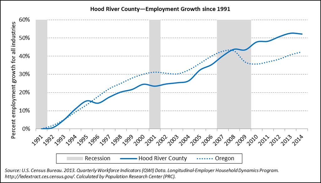
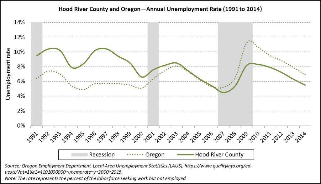
3 Agenda Population Research Center (PRC) Forecast Program overview Forecast regions Schedule Deliverables Forecasting methods and data sources Process for local input Demographic and economic trends Discussion 3
4 PRC Research areas: Oregon Census State Data Center (SDC) Demographic Research and Advisory Services Demography Instruction Oregon Population Estimates Program Oregon Population Forecast Program (OPFP) 4

5 Forecast Program Overview PRC Website: Click here for more information on OPFP 5

6 Forecast Program Overview 6


7 Forecast Program Overview Forecast Program: 4-Year Schedule Year 1 Year 2 Year 3 Year 4 Prepare County-Level Forecasts Prepare County-Level Forecasts Prepare County-Level Forecasts Program Development 1st Set of Coordinated City-County Forecasts 2nd Set of Coordinated City-County Forecasts 3rd Set of Coordinated City-County Forecasts 7
8 Forecast Program Overview Coordinated Forecast: Annual Schedule July - August Gather and update input data June Issue Final Population Forecasts Issue Final Reports September - October Build models Hold 1st public meeting Distribute data collection surveys Prepare county-level forecasts March - May Issue Preliminary Population Forecasts Hold 2nd public meeting Issue Proposed Population Forecasts 45-day official review period November - February Compile local information Develop Preliminary Forecasts 8
9 Forecast Program Overview Deliverables Forecasts (50 year horizon, 5-year time intervals) County-level forecasts (5-year age groups) Coordinated UGB-level forecasts (Total population) Report containing: Summaries of historic and future demographic trends, assumptions about future growth, and a compilation of information collected from city and county officials and the public Short technical description of methods employed to produce the forecast 9
10 Forecast Program Overview Process for Population Forecasts Develop demographic models using historic and recent data Analyze past and current population trends Reasons for change, continuous or short-term? Gather information about existing and planned future housing, and about population change Housing developments Construction of new group quarters facilities New employers Make assumptions about future housing and population change Revise forecasts on a regular basis 10
11 Forecast Program Overview Population Forecast Methods Primary Models for this Forecast Cohort-Component Method Based on age-sex structure Survival rates Fairly constant over time Fertility Slightly more variable than survival rates Migration Rates Subject to greater fluctuation than mortality and fertility and more unpredictable Generally works better for areas with larger populations 11
12 Forecast Program Overview Population Forecast Methods Primary Models for this Forecast Housing Unit Method Generally works better for areas with smaller populations Housing unit growth Housing unit type Persons per household (PPH) Occupancy rates Add group quarters population 12
13 Forecast Program Overview Population Forecast Methods Other Models/Methods to Consider For comparison and to serve as a check Ratio Methods Trend Extrapolation Employment Conversion Model 13
14 Forecast Program Overview Population Forecast Data Sources Primary Sources: U.S. Census Bureau, Decennial Censuses Population Research Center (PRC), Oregon Population Estimates Program Oregon Health Authority, Center for Health Statistics Counties, Assessors Office Incorporated cities, Community Development/Planning Department Oregon Geospatial Enterprise Office (GEO), Spatial Data Library Secondary Sources: State of Oregon, Office of Economic Analysis U.S. Census Bureau, American Community Survey (ACS) U.S., Internal Revenue Service State of Oregon, Department of Revenue Oregon Department of Education U.S., Centers for Medicare and Medicaid Services State of Oregon, Employment Department 14
15 Forecast Program Overview Process for Local Input Hold regional meetings Receive input on: Historical and current demographic and economic trends Plans for future growth Receive feed back on Preliminary Forecasts Local survey Collect local observations Population composition; recent change Planned housing development plus group quarters facilities Future employers Infrastructure Anything that might promote or hinder population growth Survey will be posted on website and ed to each jurisdiction Issued in October, 2015 Official review period for Proposed Forecasts 15
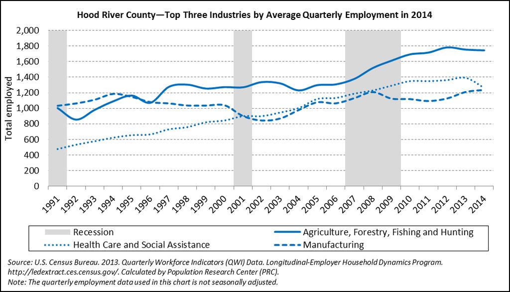
16 Hood River County 16
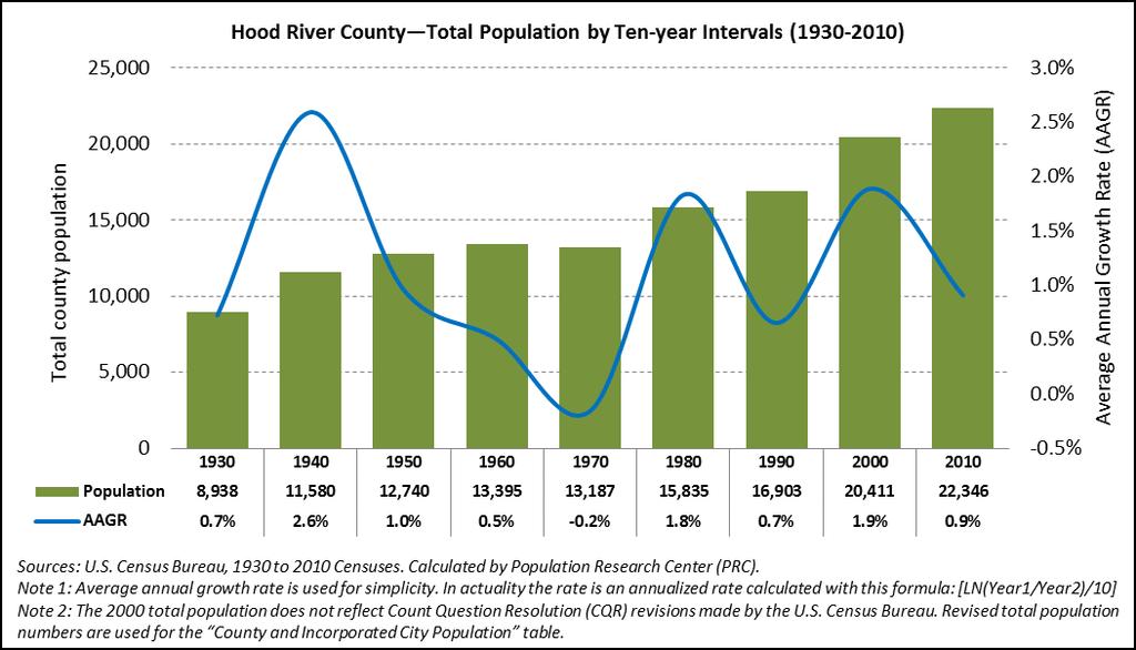
17 17
18 18
19 19
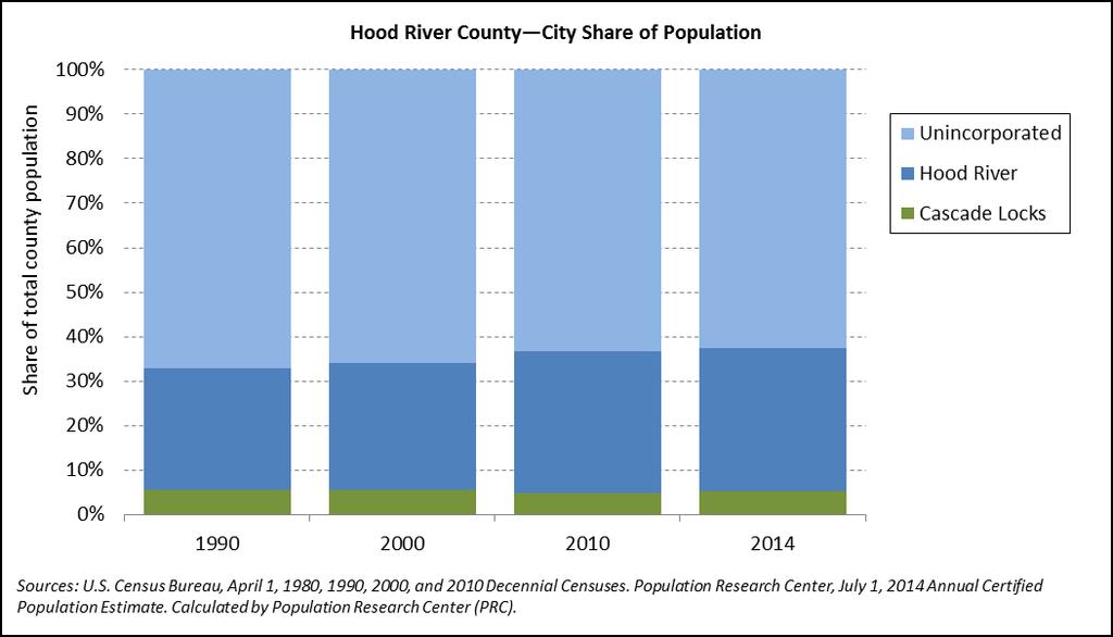
20 Hood River County and Incorporated Cities Population and Average Annual Growth Rate (AAGR) ( and ) AAGR ( ) AAGR ( ) Share of County 2000 Share of County 2010 Share of County 2014 Hood River County 20,411 22,346 23, % 1.5% 100.0% 100.0% 100.0% Cascade Locks 1,115 1,144 1, % 1.9% 5.5% 5.1% 5.2% Hood River 5,831 7,167 7, % 1.3% 28.6% 32.1% 31.8% Unincorporated 13,465 14,035 14, % 1.6% 66.0% 62.8% 63.0% Sources: U.S. Census Bureau, April 1, 2000 and 2010 Censuses. Population Research Center, July 1, 2014 Annual Intercensal Estimate. Calculated by Population Research Center (PRC). Note: The 2000 total population reflects Count Question Resolution (CQR) revisions made by the U.S. Census Bureau. 20
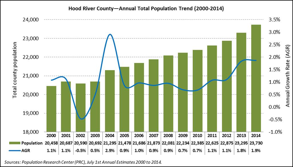
21 21
22 22
. 23")
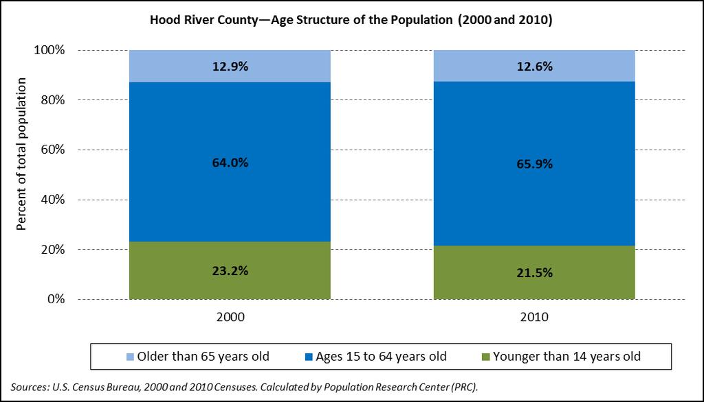
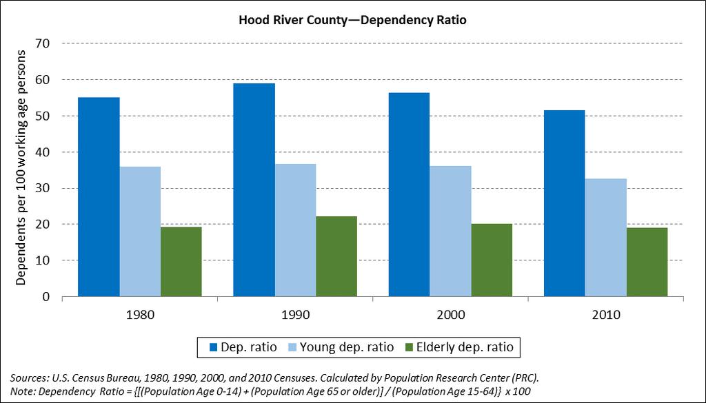
23 Hood River County Age Structure of the Population (2000 and 2010) Sources: U.S. Census Bureau, 2000 and 2010 Censuses. Calculated by Population Research Center (PRC). 23
24 24
25 Total Fertility Rate (TFR) Hood River County
26 Total Fertility Rate (TFR) 2010 Hood River County 2.11 Oregon
27 27
28 28
29 29
30 Hood River County Hispanic or Latino and Race (2000 and 2010) Hispanic or Latino and Race Absolute Change Relative Change Total population 20, % 22, % 1, % Hispanic or Latino 5, % 6, % 1, % Not Hispanic or Latino 15, % 15, % % White alone 14, % 14, % % Black or African American alone % % % American Indian and Alaska Native alone % % % Asian alone % % % Native Hawaiian and Other Pacific Islander alone % % % Some Other Race alone % % % Two or More Races % % % Sources: U.S. Census Bureau, 2000 and 2010 Censuses
31 31
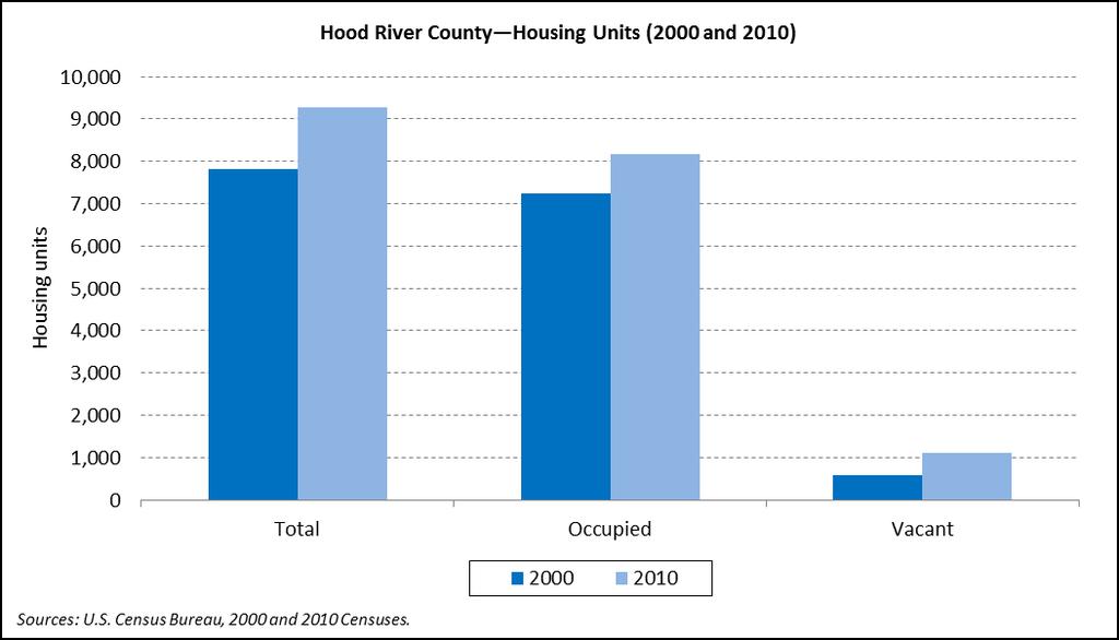
32 Hood River and Incorporated Cities Persons Per Household (PPH), Occupancy Rate, Percent Group Quarters, and Percent Seasonal Housing (2000 and 2010) Persons Per Percent Seasonal Percent Group Household (PPH) Occupancy Rate Housing Quarters Hood River County % 88.2% 2.9% 5.4% 4.3% 3.5% Cascade Locks % 88.6% 1.7% 3.0% 0.0% 0.0% Hood River % 85.6% 4.0% 7.7% 0.9% 0.8% Unincorporated % 89.8% 2.4% 4.0% 6.1% 5.2% Sources: U.S. Census Bureau, 2000 and 2010 Censuses. Calculated by Population Research Center (PRC). Note: Percent Seasonal Housing is the proportion of total housing units in 2000 and 2010 that are identified as vacant for seasonal, recreational, or occasional use. 32
33 33
34 34
35 35
36 Local Input and Additional Information Questions? Discussion time 36
Population Research Center (PRC) Oregon Population Forecast Program
 Oregon Population Forecast Program") Population Research Center (PRC) Oregon Population Forecast Program 2013 Oregon League of Cities Conference Risa S. Proehl Jason R. Jurjevich, Ph.D. Population Research Center (PRC) Population Research
Population Research Center (PRC) Oregon Population Forecast Program 2013 Oregon League of Cities Conference Risa S. Proehl Jason R. Jurjevich, Ph.D. Population Research Center (PRC) Population Research
Oregon Population Forecast Program
 Oregon Population Forecast Program Regional Forecast Meeting March 14, 2017 Preliminary Coordinated Forecasts for Washington County, its Urban Growth Boundaries (UGBs), and the Area Outside UGBs Oregon
Oregon Population Forecast Program
 Oregon Population Forecast Program Regional Forecast Meeting March 1, 2016 Preliminary Coordinated Forecasts for Umatilla County, its Urban Growth Boundaries (UGBs), and the Area Outside UGBs Oregon Population
Oregon Population Forecast Program
 Oregon Population Forecast Program Regional Forecast Meeting March 10, 2017 Preliminary Coordinated Forecasts for Columbia County, its Urban Growth Boundaries (UGBs), and the Area Outside UGBs Oregon Population
Oregon Population Forecast Program Rulemaking Advisory Committee (RAC) Population Research Center (PRC)
 Population Research Center (PRC)") Oregon Population Forecast Program Rulemaking Advisory Committee (RAC) Population Research Center (PRC) RAC Meeting Agenda 1. Committee member introductions 2. Review charge of the Oregon Population Forecast
Oregon Population Forecast Program Rulemaking Advisory Committee (RAC) Population Research Center (PRC) RAC Meeting Agenda 1. Committee member introductions 2. Review charge of the Oregon Population Forecast
OREGON POPULATION FORECAST PROGRAM
 OREGON POPULATION FORECAST PROGRAM PROGRAM OVERVIEW BACKGROUND Beginning in 1973 with the passage of Senate Bill (SB) 100, Oregon s growth management system has relied on population forecasts as the primary
COMMISSION ON ACCREDITATION 2012 ANNUAL REPORT ONLINE
 COMMISSION ON ACCREDITATION 2012 ANNUAL REPORT ONLINE SUMMARY DATA: POSTDOCTORAL PROGRAMS ^Clicking a table title will automatically direct you to that table in this document *Programs that combine two
Population, Housing and Employment Forecasts. Technical Report
 Population, Housing and Employment Forecasts Technical Report Population, Housing and Employment Forecasts Technical Report Research and Performance April 2013 A report by the Cambridgeshire County Council
ADDRESSING TITLE VI AND ENVIRONMENTAL JUSTICE IN LONG-RANGE TRANSPORTATION PLANS
 ADDRESSING TITLE VI AND ENVIRONMENTAL JUSTICE IN LONG-RANGE TRANSPORTATION PLANS Activities from the National Capital Region Transportation Planning Board Sergio Ritacco Transportation Planner 2017 Association
2010 Census Data Release and Current Geographic Programs. Michaellyn Garcia Geographer Seattle Regional Census Center
 2010 Census Data Release and Current Geographic Programs Michaellyn Garcia Geographer Seattle Regional Census Center 2010 Center of Population Located approximately 2.7 miles northeast of Plato, Missouri
COMMISSION ON ACCREDITATION 2017 ANNUAL REPORT ONLINE
 COMMISSION ON ACCREDITATION 2017 ANNUAL REPORT ONLINE SUMMARY DATA: DOCTORAL PROGRAMS ^Table titles are hyperlinks to the tables within this document INTRODUCTION The Annual Report was created in 1998
COMMISSION ON ACCREDITATION 2014 ANNUAL REPORT ONLINE
 COMMISSION ON ACCREDITATION 2014 ANNUAL REPORT ONLINE SUMMARY DATA: POSTDOCTORAL PROGRAMS ^Clicking a table title will automatically direct you to that table in this document *Programs that combine two
Institution: New Mexico Highlands University (187897) User ID: P Completions Overview distance education All Completers unduplicated count
 User ID: P Completions Overview distance education All Completers unduplicated count") Completions 207-8 Institution: New Mexico Highlands University (87897) User ID: P87897 Completions Overview Welcome to the IPEDS Completions survey component. The Completions component is one of several
Completions 207-8 Institution: New Mexico Highlands University (87897) User ID: P87897 Completions Overview Welcome to the IPEDS Completions survey component. The Completions component is one of several
Boundary and Annexation Survey (BAS)
") Boundary and Annexation Survey (BAS) New Mexico SDC Meeting Chris Wingate Geography Division U.S. Census Bureau 1 Agenda Boundary and Annexation Survey (BAS) BAS Overview American Community Survey (ACS)
Boundary and Annexation Survey (BAS) New Mexico SDC Meeting Chris Wingate Geography Division U.S. Census Bureau 1 Agenda Boundary and Annexation Survey (BAS) BAS Overview American Community Survey (ACS)
Point-in-Time Count KS-507 Kansas Balance of State CoC
 Point-in-Time Count KS-507 Kansas Balance of State CoC Population: Sheltered and Unsheltered Count Persons in Households with at least one Adult and one Child Households (Adults & Children) (under age
Understanding China Census Data with GIS By Shuming Bao and Susan Haynie China Data Center, University of Michigan
 Understanding China Census Data with GIS By Shuming Bao and Susan Haynie China Data Center, University of Michigan The Census data for China provides comprehensive demographic and business information
COMMUNITY SERVICE AREA
 INSTITUTE FOR TRIBAL ENVIRONMENTAL PROFESSIONALS Tribal Waste and Response Assistance Program (TWRAP) Developing and Implementing a Tribal Integrated Solid Waste Management Plan April 12-14, 2016 Palm
Using GIS to Brief New York City Public Officials after September 11
 Using GIS to Brief New York City Public Officials after September 11 Presented by Zvia Segal Naphtali, Ph.D. and Leonard M. Naphtali, Ph.D. Presented at the ESRI International Health GIS Conference, May
Environmental Justice Analysis FOR THE MINNESOTA STATEWIDE FREIGHT SYSTEM PLAN
 Environmental Justice Analysis FOR THE MINNESOTA STATEWIDE FREIGHT SYSTEM PLAN Presentation Overview Minnesota Freight Plan Summary Environmental Justice (EJ) Background Freight Plan EJ Analysis Methodology
Nevada s Mining Sector
 Nevada s Mining Sector Industry Summary for Nevada s Mining Sector 14,645 53.0% $107,341 Jobs () % Change (2004-) Avg. Earnings Per Job () 99% above National average Nation: 63.6% Nation: $117,598 Industry
Facts and Findings. Exhibit A-1
 Exhibit A-1 Facts and Findings The county periodically prepares coordinated countywide forecasts for all the cities in the county and the unincorporated area. These forecasts can be used by cities as a
Completions Overview. Completions Common Errors
 9//08 Print Forms (data) Completions 08-9 Institution: Hope College (7030) User ID: P7030 Completions Overview Welcome to the IPEDS Completions survey component. The Completions component is one of several
Completions Institution: CUNY Borough of Manhattan Community College User ID: 36C0029
 Completions 207-8 Institution: CUNY Borough of Manhattan Community College User ID: 36C0029 (9052) Completions Overview Welcome to the IPEDS Completions survey component. The Completions component is one
Using American Factfinder
 Using American Factfinder What is American Factfinder? American Factfinder is a search engine that provides access to the population, housing and economic data collected by the U.S. Census Bureau. It can
Life, Physical, and Social Science Occupations in Allegheny County
 Life, Physical, and Social Science Occupations in Allegheny County 2015-2025 1 Life, Physical, and Social Science Occupations Regions Code Description 42003 Allegheny County, PA Timeframe 2015-2025 Datarun
emerge Network: CERC Survey Survey Sampling Data Preparation
 emerge Network: CERC Survey Survey Sampling Data Preparation Overview The entire patient population does not use inpatient and outpatient clinic services at the same rate, nor are racial and ethnic subpopulations
COMMISSION ON ACCREDITATION 2011 ANNUAL REPORT ONLINE
 COMMISSION ON ACCREDITATION 2011 ANNUAL REPORT ONLINE SUMMARY DATA: POSTDOCTORAL PROGRAMS ^Clicking a table title will automatically direct you to that table in this document *Programs that combine two
Nevada s Mining Sector
 Nevada s Mining Sector Emsi Q4 2018 Data Set www.economicmodeling.com 1 Industry Summary for Mining 14,475 17.5% $113,786 Jobs (2018) % Change (2010-2018) Avg. Earnings Per Job (2018) 143% above National
Institution: CUNY Queensborough Community College (190673) User ID: 36C0029 Completions Overview distance education
 User ID: 36C0029 Completions Overview distance education") Completions 207-8 Institution: CUNY Queensborough Community College (90673) User ID: 36C0029 Completions Overview Welcome to the IPEDS Completions survey component. The Completions component is one of
Completions 207-8 Institution: CUNY Queensborough Community College (90673) User ID: 36C0029 Completions Overview Welcome to the IPEDS Completions survey component. The Completions component is one of
Completions Overview. Completions Common Errors
 Completions 207-8 Institution: Dakota State University (29082) User ID: P29082 Completions Overview Welcome to the IPEDS Completions survey component. The Completions component is one of several IPEDS
Completions Survey materials can be downloaded using the following link: Survey Materials.
 Completions 0- Institution: Lord Fairfax Community College (575) User ID: P575 Completions Overview Welcome to the IPEDS Completions survey component. The Completions component is one of several IPEDS
Institution: CUNY Hostos Community College (190585) User ID: 36C0029 Completions Overview distance education All Completers unduplicated count
 User ID: 36C0029 Completions Overview distance education All Completers unduplicated count") Completions 204-5 Institution: CUNY Hostos Community College (90585) User ID: 36C0029 Completions Overview Welcome to the IPEDS Completions survey component. The Completions component is one of several
Completions 204-5 Institution: CUNY Hostos Community College (90585) User ID: 36C0029 Completions Overview Welcome to the IPEDS Completions survey component. The Completions component is one of several
PROGRAM EVALUATION REPORT The following information is organized by CACREP-Accredited Program Specialty Areas for
 PROGRAM EVALUATION REPORT 2016-2017 For the 2016-2017 academic year, DePaul Counseling Program faculty conducted a program evaluation by reviewing available data and surveying stakeholders. The following
PROGRAM EVALUATION PRELIMINARY REPORT. The following information is organized by program specialty areas for
 PROGRAM EVALUATION PRELIMINARY REPORT For the 2016-2017 academic year, DePaul Counseling Program faculty conducted a program evaluation by reviewing available data and surveying stakeholders. The following
Demographic Data in ArcGIS. Harry J. Moore IV
 Demographic Data in ArcGIS Harry J. Moore IV Outline What is demographic data? Esri Demographic data - Real world examples with GIS - Redistricting - Emergency Preparedness - Economic Development Next
Institution: CUNY Bronx Community College (190530) User ID: 36C0029 Completions Overview distance education All Completers unduplicated count
 User ID: 36C0029 Completions Overview distance education All Completers unduplicated count") Completions 204-5 Institution: CUNY Bronx Community College (90530) User ID: 36C0029 Completions Overview Welcome to the IPEDS Completions survey component. The Completions component is one of several
Completions 204-5 Institution: CUNY Bronx Community College (90530) User ID: 36C0029 Completions Overview Welcome to the IPEDS Completions survey component. The Completions component is one of several
In-State Resident
 CAMPUS UW-Casper Distance 1 * UW-Casper Distance 1 HEADCOUNT for GENDER LEVEL FULL/PART-TIME FULL-TIME EQUIVALENT (FTE) ( students plus one-third of part-time students) 5,475 44 603 6,122 0 7 6,129 4,921
emerge Network: CERC Survey Survey Sampling Data Preparation
 emerge Network: CERC Survey Survey Sampling Data Preparation Overview The entire patient population does not use inpatient and outpatient clinic services at the same rate, nor are racial and ethnic subpopulations
Institution: Eastern Washington University (235097) User ID: P Completions Overview distance education All Completers unduplicated count
 User ID: P Completions Overview distance education All Completers unduplicated count") Completions 207-8 Institution: Eastern Washington University (235097) User ID: P235097 Completions Overview Welcome to the IPEDS Completions survey component. The Completions component is one of several
Completions 207-8 Institution: Eastern Washington University (235097) User ID: P235097 Completions Overview Welcome to the IPEDS Completions survey component. The Completions component is one of several
Institution: CUNY John Jay College of Criminal Justice (190600) User ID: 36C0029 Completions Overview distance education
 User ID: 36C0029 Completions Overview distance education") Completions 206-7 Institution: CUNY John Jay College of Criminal Justice (90600) User ID: 36C0029 Completions Overview Welcome to the IPEDS Completions survey component. The Completions component is one
Completions 206-7 Institution: CUNY John Jay College of Criminal Justice (90600) User ID: 36C0029 Completions Overview Welcome to the IPEDS Completions survey component. The Completions component is one
Environmental Analysis, Chapter 4 Consequences, and Mitigation
 Environmental Analysis, Chapter 4 4.17 Environmental Justice This section summarizes the potential impacts described in Chapter 3, Transportation Impacts and Mitigation, and other sections of Chapter 4,
USA SWIMMING 2015 D&I SCORECARD
 D&I SCORECARD D&I SCORECARD How the D&I Scorecard is collected and prepared In accordance with the Ted Stevens Act, the USOC s Diversity and Inclusion department annually collects diversity data from the
Presented at ESRI Education User Conference, July 6-8, 2001, San Diego, CA
 Presented at ESRI Education User Conference, July 6-8, 2001, San Diego, CA Irina V. Sharkova, Ph.D., Research Assistant Professor Richard Lycan, Ph.D., Senior Research Associate Population Research Center
USA GOLF 2013 D&I SCORECARD
 D&I SCORECARD D&I SCORECARD How the D&I Scorecard is collected and prepared In accordance with the Ted Stevens Act, the USOC s Diversity and Inclusion department annually collects diversity data from the
The European Forum for Geospatial Statistics Benefits and challenges of INSPIRE in the field of statistics
 INSPIRE Conference 2016 Barcelona, Spain 26th 30th September 2016 The European Forum for Geospatial Statistics Benefits and challenges of INSPIRE in the field of statistics Janusz Dygaszewicz EFGS President
8. Who is the university administrator responsible for verifying data (and completing IPEDS reports) at your institution?
 at your institution?") NAAB Annual Report -- I Statistical Report SECTION A. INSTITUTIONAL CHARACTERISTICS 1. Program Contact Information: Name rth Carolina State University Title School of Architecture, College of Design Office
NAAB Annual Report -- I Statistical Report SECTION A. INSTITUTIONAL CHARACTERISTICS 1. Program Contact Information: Name rth Carolina State University Title School of Architecture, College of Design Office
RISK ASSESSMENT COMMUNITY PROFILE NATURAL HAZARDS COMMUNITY RISK PROFILES. Page 13 of 524
 RISK ASSESSMENT COMMUNITY PROFILE NATURAL HAZARDS COMMUNITY RISK PROFILES Page 13 of 524 Introduction The Risk Assessment identifies and characterizes Tillamook County s natural hazards and describes how
Evaluating Community Analyst for Use in School Demography Studies
 Portland State University PDXScholar Publications, Reports and Presentations Population Research Center 7-2013 Evaluating Community Analyst for Use in School Demography Studies Richard Lycan Portland State
Utilization Analysis and, Hiring and Promotion Goals Section 46a-68-85
 Utilization Analysis (UA) Utilization Analysis and, and Promotion Goals Section 46a-68-85 In order to determine if protected groups are fully and fairly utilized in the University s workforce, the number
U.S. SOCCER FEDERATION 2014 D&I SCORECARD
 D&I SCORECARD D&I SCORECARD How the D&I Scorecard is collected and prepared How s in the USOC D&I Scorecard are derived In accordance with the Ted Stevens Act, the USOC s Diversity and Inclusion department
Module 10 Summative Assessment
 Module 10 Summative Assessment Activity In this activity you will use the three dimensions of vulnerability that you learned about in this module exposure, sensitivity, and adaptive capacity to assess
INSIDE. Metric Descriptions by Topic Area. Data Sources and Methodology by Topic Area. Technical Appendix
 As part of the Chicago Neighborhoods 2015 (CN2015) project, the Institute for Housing Studies at DePaul University collected data and built metrics to help The Chicago Community Trust and the City of Chicago
ITEM 11 Information June 20, Visualize 2045: Update to the Equity Emphasis Areas. None
 ITEM 11 Information June 20, 2018 Visualize 2045: Update to the Equity Emphasis Areas Staff Recommendation: Issues: Background: Briefing on the TPB-approved methodology to update the Equity Emphasis Areas
Integrated Postsecondary Education Data System
 University of Nebraska Omaha DigitalCommons@UNO IPEDS Completions Integrated Postsecondary Education Data System 202 Completions 202-3 UNO Office of Institutional Effectiveness University of Nebraska at
8. Who is the university administrator responsible for verifying data (and completing IPEDS reports) at your institution?
 at your institution?") NAAB Annual Report -- I Statistical Report SECTION A. INSTITUTIONAL CHARACTERISTICS 1. Program Contact Information: Name University of Louisiana - Lafayette Title School of Architecture and Design Office
NAAB Annual Report -- I Statistical Report SECTION A. INSTITUTIONAL CHARACTERISTICS 1. Program Contact Information: Name University of Louisiana - Lafayette Title School of Architecture and Design Office
Draft. Butte County Long-Term Regional Growth Forecasts
 Draft Butte County Long-Term Regional Growth Forecasts 2014 2040 Prepared by: November 25 th, 2014 2580 Sierra Sunrise Terrace, Suite 100 Chico, CA 95928 Phone: 530-879-2468 FAX: 530-879-244 www.bcag.org
Completions Survey materials can be downloaded using the following link: Survey Materials.
 Completions 203-4 Institution: CUNY New York City College of Technology (90655) User ID: 36C0022 Completions Overview Welcome to the IPEDS Completions survey component. The Completions component is one
SOUTH COAST COASTAL RECREATION METHODS
 SOUTH COAST COASTAL RECREATION METHODS A customized, web-based survey instrument, which utilizes Point 97 s Viewpoint survey and mapping technology, was used to collect spatially explicit data on coastal
Summary and Statistical Report of the 2007 Population and Housing Census Results 1
 Summary and Statistical Report of the 2007 Population and Housing Census Results 1 2 Summary and Statistical Report of the 2007 Population and Housing Census Results This document was printed by United
Overview of Technical Advisory Missions
 Expert Group Meeting (EGM) on Georeferenced Information Systems for Disaster Risk Management (Geo-DRM) and sustaining the Community of Practice (COP) 23-25 April 2014 Bangkok Overview of Technical Advisory
NAAB Annual Report -- Part I Statistical Report SECTION A. INSTITUTIONAL CHARACTERISTICS
 NAAB Annual Report -- I Statistical Report SECTION A. INSTITUTIONAL CHARACTERISTICS 1. Program Contact Information: Name Pennsylvania State University Title Department of Architecture Office Phone Number
The 2020 Census Geographic Partnership Opportunities
 The 2020 Census Geographic Partnership Opportunities Web Adams Geographer, U.S. Census Bureau New York Regional Office 1 Geographic Partnership Opportunities The 2020 Census Local Update of Census Addresses
Enrollment at a Glance Fall 2015
 1. Number of Students Enrolled at Tenth Day of Fall Term 2011 2012 2013 2014 2015 3,705 ( 100.0% ) 3,626 ( 100.0% ) 3,706 ( 100.0% ) 3,746 ( 100.0% ) 3,891 ( 100.0% ) New 1 1,051 ( 28.4% ) 1,063 ( 29.3%
OnTheMap for Emergency Management
 OnTheMap for Emergency Management Robert Pitts Geographer/Project Manager Longitudinal Employer Household Dynamics (LEHD) Center for Economic Studies U.S. Census Bureau Jody Hoon-Star Geographer/Application
2014 Planning Database (PDB)
") 2014 Planning Database (PDB) November 19, 2014 Barbara O Hare, Nancy Bates, Julia Coombs, Travis Pape, Chandra Erdman Office of Survey Analytics 1 Overview Tract and Block Group PDBs Useful for: Identifying
2014 Planning Database (PDB) November 19, 2014 Barbara O Hare, Nancy Bates, Julia Coombs, Travis Pape, Chandra Erdman Office of Survey Analytics 1 Overview Tract and Block Group PDBs Useful for: Identifying
LEO Catchment Profile (LCP) Key Data for Enterprise Strategy
 Key Data for Enterprise Strategy") Laois...Portarlington LEO Catchment Profile (LCP) Key Data for Enterprise Strategy Laois Local Enterprise Office Address: Business Support Unit, County Hall, Portlaoise, County Laois Web: https://www.localenterprise.ie/laois/
Laois...Portarlington LEO Catchment Profile (LCP) Key Data for Enterprise Strategy Laois Local Enterprise Office Address: Business Support Unit, County Hall, Portlaoise, County Laois Web: https://www.localenterprise.ie/laois/
Webinar Series for Comprehensive Plan Updates. School Districts: More than just an affected jurisdiction
 Webinar Series for Comprehensive Plan Updates School Districts: More than just an affected jurisdiction Presented by Tara Beard, AICP March 9, 2017 Goals for this webinar City planning staff are more aware
GEOGRAPHIC INFORMATION SYSTEMS Session 8
 GEOGRAPHIC INFORMATION SYSTEMS Session 8 Introduction Geography underpins all activities associated with a census Census geography is essential to plan and manage fieldwork as well as to report results
Population Trends Along the Coastal United States:
 Coastal Trends Report Series Population Trends Along the Coastal United States: 1980-2008 U.S. Department of Commerce National Oceanic and Atmospheric Administration National Ocean Service Assessing the
Institution: CUNY Hostos Community College (190585) User ID: 36C0029 Completions Overview distance education All Completers unduplicated count
 User ID: 36C0029 Completions Overview distance education All Completers unduplicated count") Completions 205-6 Institution: CUNY Hostos Community College (90585) User ID: 36C0029 Completions Overview Welcome to the IPEDS Completions survey component. The Completions component is one of several
Completions 205-6 Institution: CUNY Hostos Community College (90585) User ID: 36C0029 Completions Overview Welcome to the IPEDS Completions survey component. The Completions component is one of several
Completions Overview. Recent Changes
 Completions 0-3 Institution: University of North Florida (36) Completions Overview User ID: P364 Welcome to the IPEDS Completions survey component. The Completions component is one of several IPEDS components
GLA small area population projection methodology
 Update 2017-04 GLA small area population projection methodology 2015-based projections February 2017 Introduction The GLA produces a range of annually updated demographic projections for London. Among
EXAMINING THE DEMOGRAPHICS OF THE DOG RIVER WATERSHED
 EXAMINING THE DEMOGRAPHICS OF THE DOG RIVER WATERSHED Phillip B. Whatley, Department of Earth Sciences, University of South Alabama, Mobile, AL, 36688. Email: pbw401@jaguar1.usouthal.edu. Examining the
8. Who is the university administrator responsible for verifying data (and completing IPEDS reports) at your institution?
 at your institution?") NAAB Annual Report -- I Statistical Report SECTION A. INSTITUTIONAL CHARACTERISTICS 1. Program Contact Information: Name rth Carolina State University Title School of Architecture, College of Design Office
NAAB Annual Report -- I Statistical Report SECTION A. INSTITUTIONAL CHARACTERISTICS 1. Program Contact Information: Name rth Carolina State University Title School of Architecture, College of Design Office
An Introduction to China and US Map Library. Shuming Bao Spatial Data Center & China Data Center University of Michigan
 An Introduction to China and US Map Library Shuming Bao Spatial Data Center & China Data Center University of Michigan Current Spatial Data Services http://chinadataonline.org China Geo-Explorer http://chinageoexplorer.org
Spotlight on Population Resources for Geography Teachers. Pat Beeson, Education Services, Australian Bureau of Statistics
 Spotlight on Population Resources for Geography Teachers Pat Beeson, Education Services, Australian Bureau of Statistics Population Population size Distribution Age Structure Ethnic composition Gender
EQUAL EMPLOYMENT OPPORTUNITY PLAN
 City of Shawnee HUMAN RESOURCE DEPARTMENT PO BOX 1448 Shawnee, OK 74802 Phone: (405) 878-1626 Fax: (405) 878-1734 2014-2015 through 2016-2017 UPDATED November 2017 EQUAL EMPLOYMENT OPPTUNITY PLAN The City
Analyzing the Geospatial Rates of the Primary Care Physician Labor Supply in the Contiguous United States
 Analyzing the Geospatial Rates of the Primary Care Physician Labor Supply in the Contiguous United States By Russ Frith Advisor: Dr. Raid Amin University of W. Florida Capstone Project in Statistics April,
Bengt Kjellson Chair of the Executive Committee UN-GGIM: Europe. 2 nd Joint UN-GGIM: Europe ESS Meeting 11 th March 2016, Luxembourg
 Bengt Kjellson Chair of the Executive Committee UN-GGIM: Europe 2 nd Joint UN-GGIM: Europe ESS Meeting 11 th March 2016, Luxembourg A global geospatial mandate At its 47th plenary in July 2011, ECOSOC,
Reducing Vulnerability to Extreme Heat: Science-Policy Interface
 Reducing Vulnerability to Extreme Heat: Science-Policy Interface Olga Wilhelmi, Mary Hayden, Jennifer Boehnert, Ursula Lauper and SIMMER research team October 23, 2013 Toronto SIMMER workshop Science-Policy
Economics 390 Economic Forecasting
 Economics 390 Economic Forecasting Prerequisite: Econ 410 or equivalent Course information is on website Office Hours Tuesdays & Thursdays 2:30 3:30 or by appointment Textbooks Forecasting for Economics
IN-NETWORK CHLORINE RESIDUAL MANAGEMENT
 IN-NETWORK CHLORINE RESIDUAL MANAGEMENT Using GIS to assess flush point efficacy Ian Toohey, P.E. Systems Planning Austin Water TABLE OF CONTENTS 1. Background 3. Surface Creation 2. Residual Sampling
Enhancing Louisiana s GNIS
 Enhancing Louisiana s GNIS An Outreach Effort Between USGS and the Louisiana Geographic Information Center Louisiana Remote Sensing and GIS Workshop Lafayette, LA April 28, 2010 Louisiana Geographic Information
Intercity Bus Stop Analysis
 by Karalyn Clouser, Research Associate and David Kack, Director of the Small Urban and Rural Livability Center Western Transportation Institute College of Engineering Montana State University Report prepared
HORIZON 2030: Land Use & Transportation November 2005
 PROJECTS Land Use An important component of the Horizon transportation planning process involved reviewing the area s comprehensive land use plans to ensure consistency between them and the longrange transportation
US Census Bureau Geographic Entities and Concepts. Geography Division
 US Census Bureau Geographic Entities and Concepts Geography Division Geographic Concepts Addresses vs. Geographic features and entities Legal/Administrative vs. Statistical Nesting relationships (or the
GIS ADMINISTRATOR / WEB DEVELOPER EVANSVILLE-VANDERBURGH COUNTY AREA PLAN COMMISSION
 GIS ADMINISTRATOR / WEB DEVELOPER EVANSVILLE-VANDERBURGH COUNTY AREA PLAN COMMISSION SALARY RANGE INITIATION $43,277 SIX MONTHS $45,367 POSITION GRADE PAT VI The Evansville-Vanderburgh County Area Plan
Census Transportation Planning Products (CTPP)
") Census Transportation Planning Products (CTPP) Penelope Weinberger CTPP Program Manager - AASHTO September 15, 2010 1 What is the CTPP Program Today? The CTPP is an umbrella program of data products, custom
Census Transportation Planning Products (CTPP) Penelope Weinberger CTPP Program Manager - AASHTO September 15, 2010 1 What is the CTPP Program Today? The CTPP is an umbrella program of data products, custom
Extreme Temperature Protocol in Middlesex-London
 Clean Air Partnership Webinar March 17, 2009 Extreme Temperature Protocol in Middlesex-London Presented by Iqbal Kalsi, MBA, CPHI(C), CCEP iqbal.kalsi@mlhu.on.ca 1 History Informal monitoring, tracking
Easy Analytic Software, Inc. (EASI) Methodology Demographics, Related Data, and Life Stage Clusters
 Methodology Demographics, Related Data, and Life Stage Clusters") (EASI) Methodology Demographics, Related Data, and Life Stage Clusters Thank you for interest in (EASI) and The Right Site. We have included a description of our company, and a description of our basic
(EASI) Methodology Demographics, Related Data, and Life Stage Clusters Thank you for interest in (EASI) and The Right Site. We have included a description of our company, and a description of our basic
Working with Census Operations Case Study from KSA
 Working with Census Operations Case Study from KSA International Workshop on Integrating Geospatial and Statistical Information Beijing 9 12 June 2014 Abdullah M.Alhamlan Kingdom of Saudi Arabia Central
EICCARS WORKBOOK FOR INITIATING COMMUNITY PROFILES WITH STATISTICAL AND OTHER SECONDARY DATA
 The Cultural Ecology of Health and Change (CEHC) Working Papers Ethnographically Informed Community and Cultural Assessment Research Systems (EICCARS) Workbooks EICCARS WORKBOOK FOR INITIATING COMMUNITY
Social Vulnerability Index. Susan L. Cutter Department of Geography, University of South Carolina
 Social Vulnerability Index Susan L. Cutter Department of Geography, University of South Carolina scutter@sc.edu Great Lakes and St. Lawrence Cities Initiative Webinar December 3, 2014 Vulnerability The
CALOTS Upgrade for Performance Monitoring
 CALOTS Upgrade for Performance Monitoring A project of the Southern California Association of Governments supported by the UCLA Lewis Center for Regional Policy Studies Agenda 1. Revisit Project Overview
The Church Demographic Specialists
 The Church Demographic Specialists Easy-to-Use Features Map-driven, Web-based Software An Integrated Suite of Information and Query Tools Providing An Insightful Window into the Communities You Serve Key
Completions Overview. Recent Changes
 Completions 2015-16 Completions Overview Welcome to the IPEDS Completions survey component. The Completions component is one of several IPEDS components that is conducted during the Fall data collection
Presented to Sub-regional workshop on integration of administrative data, big data and geospatial information for the compilation of SDG indicators
 Presented to Sub-regional workshop on integration of administrative data, big data and geospatial information for the compilation of SDG indicators 23-25 April,2018 Addis Ababa, Ethiopia By: Deogratius
The Future of Met Council Forecasts
 The Future of Met Council Forecasts Todd Graham todd.graham@metc.state.mn.us Dennis Farmer dennis.farmer@metc.state.mn.us Metropolitan Council Research Today s Agenda Why we forecast, how we use forecasts
Community and Infrastructure Services Committee
 REPORT TO: DATE OF MEETING: November 7, 2016 Community and Infrastructure Services Committee SUBMITTED BY: Cynthia Fletcher, Interim Executive Director INS 519-741- PREPARED BY: WARD(S) INVOLVED: 2600
St. Luke s College Institutional Snapshot
 1. Student Headcount St. Luke s College Institutional Snapshot Enrollment # % # % # % Full Time 139 76% 165 65% 132 54% Part Time 45 24% 89 35% 112 46% Total 184 254 244 2. Average Age Average Age Average