Population Research Center (PRC) Oregon Population Forecast Program
|
|
|
- Gervais McKenzie
- 6 years ago
- Views:
Transcription


1 Population Research Center (PRC) Oregon Population Forecast Program 2013 Oregon League of Cities Conference Risa S. Proehl Jason R. Jurjevich, Ph.D. Population Research Center (PRC)

2 Population Research Center (PRC) Research Areas: Oregon State Data Center (SDC) Demographic Advisory Services Applied Demography Instruction Oregon Population Estimates Program Oregon Population Forecast Program [Today s Focus]
3 Oregon Population Estimates Program Population Estimates Refers to a point in time estimate of population in the present or in the past Usual estimate date of July 1 Distribution of state revenue to communities Primary data collection instrument: Annual Estimates Survey Now electronic!
4 Population Forecasts Population Forecasts An estimation of future population based on historic and current trends, and assumptions about likely future events Oregon law requires counties to prepare and update coordinated population forecasts 20-year horizon Serve as the basis for growth management UGB expansions Planning-related issues (transportation planning, school facility plans, and capital improvement)
5 Population Forecast Workgroup June 2011 Oregon stakeholders meet to identify and address concerns specific to population forecasting and Oregon land-use laws Some identified issues: Cost Different demographic methods City and county coordination Outdated population forecasts Controversial and subject to litigation
6 Outlining a New Way Forward for Population Forecasting Presentation objectives: 1. What is the Oregon Population Forecast Program? 2. What do the changes in population forecasting mean for my city? 3. What are the benefits of the Oregon Population Forecast Program? 4. In the coming months, what can I expect (in terms of process) and how can I prepare my city to be ready for these changes?
7 Oregon Population Forecast Program 1. Charges PSU with city-county coordinated population forecasting (reassigned from counties) 2. PSU provides county-level forecasts annually, and; 3. Coordinated city-county forecasts every four years 4. Process is dependent on local public input and public participation


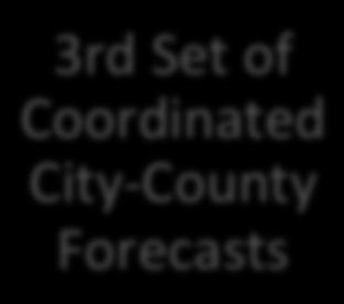
8 Oregon Population Forecast Program: 4-Year Schedule Year 1 Year 2 Year 3 Year 4 County- Level Forecasts* Update County- Level Forecasts 1st Set of Coordinated City- County Forecasts Update County- Level Forecasts 2nd Set of Coordinated City- County Forecasts Update County- Level Forecasts 3rd Set of Coordinated City- County Forecasts *Includes 5-year age groups by sex
9 Benefits of the Oregon Population Forecast Program Updated, timely forecasts 50-year time horizon for other planning requirements Consistent forecast methodology Systematic incorporation of local and public input Reduction of challenges and lawsuits Adoption of PSU forecast is not a land-use decision and therefore, not appealable to LUBA
10 Benefits of the Oregon Population Forecast Program Improved efficiency Allows us to leverage data from existing Population Estimates program Fully funded by state resources Cost savings to cities and counties
11 Population Forecasting Models Cohort-Component model Disaggregates population into 5-year age cohorts and explicitly assumes: Likelihood of demographic events (fertility, mortality, and migration) is inextricably linked to a persons gender and age Housing Unit model Population forecasts driven by total housing units, occupancy rate, and persons per household Includes group quarters populations
12 Types of Data Collected Primary data 1. Public officials, planners, and other city personnel 2. Housing developer survey Secondary data U.S. Census Bureau 2000 and 2010 decennial Censuses of Population and Housing Enumerated population by age and sex, and housing American Community Survey (ACS) Migration, income, poverty, and educational attainment Oregon Employment Department, Workforce and Economic Research Historical and current employment data, and projections General economic trends Likely future employers
13 Types of Data Collected Secondary data continued Oregon Department of Transportation Transportation infrastructure Future plans Oregon Center for Health Statistics Birth and death data Population Research Center (PRC) Certified annual population estimates Oregon Department of Education K-12 school enrollment data City, Regional, and County Planning departments Qualitative data not obtained in surveys
14 Local and Public Input Two meetings 1 st meeting (Month 2) Explain forecasting methodology and process Gather additional data and local input Provide background of locally-specific demographic trends 2 nd meeting (Month 8) Provide officials with proposed forecast results Seek input for potential modifications Gather additional data and local input not previously received


15 Proposed Annual Coordinated Forecast Approach Month 1 Update county- level forecasts Month 2 Hold 1st public meedng Month 3 Distribute data collecdon surveys Months 4-6 Build models Accept addidonal data Month 7 Release Preliminary Forecasts Month 8 Hold 2nd public meedng Month 9 Issue Proposed PopulaDon Forecast Begin Review period Month 11 Issue Final PopulaDon Forecast Challenge process Commences with the release of the proposed population forecast 45 day review period during which a city can challenge the forecast by providing additional information to support proposed change
16 Deliverables Annual county-level forecasts [Years 1-4] 50 year horizon 5-year age cohorts by sex Coordinated county and city-level (UGB) forecasts [Years 2-4] Report containing: Includes information for all cities and counties Summary of demographic trends, data gathered from surveys, information collected from city and county officials, as well as the public, and assumptions about future growth Short technical document specific to forecast methods employed
17 Forecast Program Timeline 1. Currently developing an advisory committee to develop program rules Timeline: October - November Program planning, database development, and county forecast logistics Timeline: October - December Develop county-level population forecasts Timeline: December 2013 May Develop 1 st set of city-county coordinated forecasts Timeline: July 2014 June 2015
18 Oregon Population Forecast Program Team Xiaomin Ruan, Coordinator Kevin Rancik, GIS Analyst Risa Proehl Jason Jurjevich


19 PRC Website:
20 Population Research Center (PRC) Oregon Population Forecast Program 2013 Oregon League of Cities Conference Jason R. Jurjevich, Ph.D. Risa S. Proehl Population Research Center (PRC)
Oregon Population Forecast Program Rulemaking Advisory Committee (RAC) Population Research Center (PRC)
 Population Research Center (PRC)") Oregon Population Forecast Program Rulemaking Advisory Committee (RAC) Population Research Center (PRC) RAC Meeting Agenda 1. Committee member introductions 2. Review charge of the Oregon Population Forecast
Oregon Population Forecast Program Rulemaking Advisory Committee (RAC) Population Research Center (PRC) RAC Meeting Agenda 1. Committee member introductions 2. Review charge of the Oregon Population Forecast
Oregon Population Forecast Program
 Oregon Population Forecast Program Regional Forecast Meeting October 2, 2015 Presentation by Population Forecast Program Team Hood River County Oregon Population Forecast Program Project Team Xiaomin Ruan,
Oregon Population Forecast Program
 Oregon Population Forecast Program Regional Forecast Meeting March 1, 2016 Preliminary Coordinated Forecasts for Umatilla County, its Urban Growth Boundaries (UGBs), and the Area Outside UGBs Oregon Population
OREGON POPULATION FORECAST PROGRAM
 OREGON POPULATION FORECAST PROGRAM PROGRAM OVERVIEW BACKGROUND Beginning in 1973 with the passage of Senate Bill (SB) 100, Oregon s growth management system has relied on population forecasts as the primary
Oregon Population Forecast Program
 Oregon Population Forecast Program Regional Forecast Meeting March 10, 2017 Preliminary Coordinated Forecasts for Columbia County, its Urban Growth Boundaries (UGBs), and the Area Outside UGBs Oregon Population
Oregon Population Forecast Program
 Oregon Population Forecast Program Regional Forecast Meeting March 14, 2017 Preliminary Coordinated Forecasts for Washington County, its Urban Growth Boundaries (UGBs), and the Area Outside UGBs Oregon
GLA small area population projection methodology
 Update 2017-04 GLA small area population projection methodology 2015-based projections February 2017 Introduction The GLA produces a range of annually updated demographic projections for London. Among
Understanding China Census Data with GIS By Shuming Bao and Susan Haynie China Data Center, University of Michigan
 Understanding China Census Data with GIS By Shuming Bao and Susan Haynie China Data Center, University of Michigan The Census data for China provides comprehensive demographic and business information
Presented at ESRI Education User Conference, July 6-8, 2001, San Diego, CA
 Presented at ESRI Education User Conference, July 6-8, 2001, San Diego, CA Irina V. Sharkova, Ph.D., Research Assistant Professor Richard Lycan, Ph.D., Senior Research Associate Population Research Center
The Future of Met Council Forecasts
 The Future of Met Council Forecasts Todd Graham todd.graham@metc.state.mn.us Dennis Farmer dennis.farmer@metc.state.mn.us Metropolitan Council Research Today s Agenda Why we forecast, how we use forecasts
Date: March 31, 2014 PATE; fyril 2.3,2 >H
 aj BRAMPTON fifs Rower City XH-l-f r.t "»* City Council The Corporation of the City of Brampton SRAMPTON CITY COUNCIL Date: March 31, 2014 PATE; fyril 2.3,2 >H File: POO GR VisWhtoJed ^t'th-meeh'^a Subject:
Facts and Findings. Exhibit A-1
 Exhibit A-1 Facts and Findings The county periodically prepares coordinated countywide forecasts for all the cities in the county and the unincorporated area. These forecasts can be used by cities as a
2010 Census Data Release and Current Geographic Programs. Michaellyn Garcia Geographer Seattle Regional Census Center
 2010 Census Data Release and Current Geographic Programs Michaellyn Garcia Geographer Seattle Regional Census Center 2010 Center of Population Located approximately 2.7 miles northeast of Plato, Missouri
Evaluating Community Analyst for Use in School Demography Studies
 Portland State University PDXScholar Publications, Reports and Presentations Population Research Center 7-2013 Evaluating Community Analyst for Use in School Demography Studies Richard Lycan Portland State
GEOGRAPHIC INFORMATION SYSTEMS Session 8
 GEOGRAPHIC INFORMATION SYSTEMS Session 8 Introduction Geography underpins all activities associated with a census Census geography is essential to plan and manage fieldwork as well as to report results
Demographic Data in ArcGIS. Harry J. Moore IV
 Demographic Data in ArcGIS Harry J. Moore IV Outline What is demographic data? Esri Demographic data - Real world examples with GIS - Redistricting - Emergency Preparedness - Economic Development Next
An online data and consulting resource of THE UNIVERSITY OF TOLEDO THE JACK FORD URBAN AFFAIRS CENTER
 An online data and consulting resource of THE JACK FORD URBAN AFFAIRS CENTER THE CENTER FOR GEOGRAPHIC INFORMATION SCIENCE AND APPLIED GEOGRAPHICS DEPARTMENT OF GEOGRAPHY AND PLANNING THE UNIVERSITY OF
Using American Factfinder
 Using American Factfinder What is American Factfinder? American Factfinder is a search engine that provides access to the population, housing and economic data collected by the U.S. Census Bureau. It can
Globally Estimating the Population Characteristics of Small Geographic Areas. Tom Fitzwater
 Globally Estimating the Population Characteristics of Small Geographic Areas Tom Fitzwater U.S. Census Bureau Population Division What we know 2 Where do people live? Difficult to measure and quantify.
An Internet-Based Integrated Resource Management System (IRMS)
") An Internet-Based Integrated Resource Management System (IRMS) Third Quarter Report, Year II 4/1/2000 6/30/2000 Prepared for Missouri Department of Natural Resources Missouri Department of Conservation
An Internet-Based Integrated Resource Management System (IRMS) Third Quarter Report, Year II 4/1/2000 6/30/2000 Prepared for Missouri Department of Natural Resources Missouri Department of Conservation
WRF Webcast. Improving the Accuracy of Short-Term Water Demand Forecasts
 No part of this presentation may be copied, reproduced, or otherwise utilized without permission. WRF Webcast Improving the Accuracy of Short-Term Water Demand Forecasts August 29, 2017 Presenters Maureen
Population, Housing and Employment Forecasts. Technical Report
 Population, Housing and Employment Forecasts Technical Report Population, Housing and Employment Forecasts Technical Report Research and Performance April 2013 A report by the Cambridgeshire County Council
THE FUTURE OF FORECASTING AT METROPOLITAN COUNCIL. CTS Research Conference May 23, 2012
 THE FUTURE OF FORECASTING AT METROPOLITAN COUNCIL CTS Research Conference May 23, 2012 Metropolitan Council forecasts Regional planning agency and MPO for Twin Cities metropolitan area Operates regional
BUILDING SOUND AND COMPARABLE METRICS FOR SDGS: THE CONTRIBUTION OF THE OECD DATA AND TOOLS FOR CITIES AND REGIONS
 BUILDING SOUND AND COMPARABLE METRICS FOR SDGS: THE CONTRIBUTION OF THE OECD DATA AND TOOLS FOR CITIES AND REGIONS STATISTICAL CAPACITY BUILDING FOR MONITORING OF SUSTAINABLE DEVELOPMENT GOALS Lukas Kleine-Rueschkamp
A User s Guide to the Federal Statistical Research Data Centers
 A User s Guide to the Federal Statistical Research Data Centers Mark Roberts Professor of Economics and Director PSU FSRDC September 2016 M. Roberts () RDC User s Guide September 2016 1 / 14 Outline Introduction
The Church Demographic Specialists
 The Church Demographic Specialists Easy-to-Use Features Map-driven, Web-based Software An Integrated Suite of Information and Query Tools Providing An Insightful Window into the Communities You Serve Key
Environmental Analysis, Chapter 4 Consequences, and Mitigation
 Environmental Analysis, Chapter 4 4.17 Environmental Justice This section summarizes the potential impacts described in Chapter 3, Transportation Impacts and Mitigation, and other sections of Chapter 4,
OnTheMap for Emergency Management
 OnTheMap for Emergency Management Robert Pitts Geographer/Project Manager Longitudinal Employer Household Dynamics (LEHD) Center for Economic Studies U.S. Census Bureau Jody Hoon-Star Geographer/Application
Boundary and Annexation Survey (BAS)
") Boundary and Annexation Survey (BAS) New Mexico SDC Meeting Chris Wingate Geography Division U.S. Census Bureau 1 Agenda Boundary and Annexation Survey (BAS) BAS Overview American Community Survey (ACS)
Boundary and Annexation Survey (BAS) New Mexico SDC Meeting Chris Wingate Geography Division U.S. Census Bureau 1 Agenda Boundary and Annexation Survey (BAS) BAS Overview American Community Survey (ACS)
Reducing Vulnerability to Extreme Heat: Science-Policy Interface
 Reducing Vulnerability to Extreme Heat: Science-Policy Interface Olga Wilhelmi, Mary Hayden, Jennifer Boehnert, Ursula Lauper and SIMMER research team October 23, 2013 Toronto SIMMER workshop Science-Policy
Population and Employment Forecast
 Population and Employment Forecast How Do We Get the Numbers? Thurston Regional Planning Council Technical Brief Updated July 2012 We plan for forecast growth in Population and Employment, but where do
Ministry of Health and Long-Term Care Geographic Information System (GIS) Strategy An Overview of the Strategy Implementation Plan November 2009
 Strategy An Overview of the Strategy Implementation Plan November 2009") Ministry of Health and Long-Term Care Geographic Information System (GIS) Strategy An Overview of the Strategy Implementation Plan November 2009 John Hill, Health Analytics Branch Health System Information
Ministry of Health and Long-Term Care Geographic Information System (GIS) Strategy An Overview of the Strategy Implementation Plan November 2009 John Hill, Health Analytics Branch Health System Information
Technical Report: Population
 Cherokee County orecasts Technical Report: An Element of the Joint Comprehensive Plan For Cherokee County and the Cities of Ball Ground, Waleska and Woodstock, Georgia Plan Cherokee Team: ROSS+associates
FHWA Planning Data Resources: Census Data Planning Products (CTPP) HEPGIS Interactive Mapping Portal
 HEPGIS Interactive Mapping Portal") FHWA Planning Data Resources: Census Data Planning Products (CTPP) HEPGIS Interactive Mapping Portal Jeremy Raw, P.E. FHWA, Office of Planning, Systems Planning and Analysis August 2017 Outline Census
FHWA Planning Data Resources: Census Data Planning Products (CTPP) HEPGIS Interactive Mapping Portal Jeremy Raw, P.E. FHWA, Office of Planning, Systems Planning and Analysis August 2017 Outline Census
GIS Lecture 5: Spatial Data
 GIS Lecture 5: Spatial Data GIS 1 Outline Vector Data Formats Raster Data Formats Map Projections Coordinate Systems US Census geographic files US Census data files GIS Data Sources GIS 2 Vector Data Formats
Spotlight on Population Resources for Geography Teachers. Pat Beeson, Education Services, Australian Bureau of Statistics
 Spotlight on Population Resources for Geography Teachers Pat Beeson, Education Services, Australian Bureau of Statistics Population Population size Distribution Age Structure Ethnic composition Gender
Introduction to Forecasting
 Introduction to Forecasting Introduction to Forecasting Predicting the future Not an exact science but instead consists of a set of statistical tools and techniques that are supported by human judgment
E-Community Check Request Checklist
 E-Community Check Request Checklist The E-Community must complete the following information on each business approved for a loan or grant in order for the Kansas Center of Entrepreneurship (KCFE) to disburse
Combining Geospatial and Statistical Data for Analysis & Dissemination
 Combining Geospatial and Statistical Data for Analysis & Dissemination (with Special Reference to Qatar Census 2010) Presentation by Mansoor Al Malki, Director of IT Department Qatar Statistics Authority
Climate and Health Vulnerability & Adaptation Assessment Profile Manaus - Brazil
 Climate and Health Vulnerability & Adaptation Assessment Profile Manaus - Brazil Christovam Barcellos (ICICT/Fiocruz) Diego Xavier Silva (ICICT/Fiocruz) Rita Bacuri (CPqLMD/Fiocruz) Assessment Objectives
Methodology used in preparing the estimates and projections of the urban and rural population and the economically active population
 CEPAL América Latina y el Caribe. Observatorio demográfico Nº 2 Población económicamente activa Methodology used in preparing the estimates and projections of the urban and rural population and the economically
Applying Health Outcome Data to Improve Health Equity
 Applying Health Outcome Data to Improve Health Equity Devon Williford, MPH, Health GIS Specialist Lorraine Dixon-Jones, Policy Analyst CDPHE Health Equity and Environmental Justice Collaborative Mile High
GOVERNMENT MAPPING WORKSHOP RECOVER Edmonton s Urban Wellness Plan Mapping Workshop December 4, 2017
 GOVERNMENT MAPPING WORKSHOP 12.4.17 RECOVER Edmonton s Urban Wellness Plan Mapping Workshop December 4, 2017 In July of 2017, City Council directed administration to develop RECOVER, Edmonton s Urban Wellness
Council Workshop on Neighbourhoods Thursday, October 4 th, :00 to 4:00 p.m. Burlington Performing Arts Centre
 Council Workshop on Neighbourhoods Thursday, October 4 th, 2012 1:00 to 4:00 p.m. Burlington Performing Arts Centre Agenda Introductions Warm-Up Exercise Presentation Exercise Neighbourhood Planning Break
Technical Memorandum #2 Future Conditions
 Technical Memorandum #2 Future Conditions To: Dan Farnsworth Transportation Planner Fargo-Moorhead Metro Council of Governments From: Rick Gunderson, PE Josh Hinds PE, PTOE Houston Engineering, Inc. Subject:
SPATIAL ANALYSIS OF POPULATION DATA BASED ON GEOGRAPHIC INFORMATION SYSTEM
 SPATIAL ANALYSIS OF POPULATION DATA BASED ON GEOGRAPHIC INFORMATION SYSTEM Liu, D. Chinese Academy of Surveying and Mapping, 16 Beitaiping Road, Beijing 100039, China. E-mail: liudq@casm.ac.cn ABSTRACT
On Page 1, following Paragraph 2 of the Planning Participants subsection, insert the following: 2012 Committee members included:
 Appendix 4: City of West Linn Addendum to the Clackamas County Natural Hazards Mitigation Plan 2012 Amendments and Update The Oregon Partnership for Disaster Resilience prepared this Appendix to the City
1Department of Demography and Organization Studies, University of Texas at San Antonio, One UTSA Circle, San Antonio, TX
 Well, it depends on where you're born: A practical application of geographically weighted regression to the study of infant mortality in the U.S. P. Johnelle Sparks and Corey S. Sparks 1 Introduction Infant
DEVELOPING DECISION SUPPORT TOOLS FOR THE IMPLEMENTATION OF BICYCLE AND PEDESTRIAN SAFETY STRATEGIES
 DEVELOPING DECISION SUPPORT TOOLS FOR THE IMPLEMENTATION OF BICYCLE AND PEDESTRIAN SAFETY STRATEGIES Deo Chimba, PhD., P.E., PTOE Associate Professor Civil Engineering Department Tennessee State University
Census Transportation Planning Products (CTPP)
") Census Transportation Planning Products (CTPP) Penelope Weinberger CTPP Program Manager - AASHTO September 15, 2010 1 What is the CTPP Program Today? The CTPP is an umbrella program of data products, custom
Census Transportation Planning Products (CTPP) Penelope Weinberger CTPP Program Manager - AASHTO September 15, 2010 1 What is the CTPP Program Today? The CTPP is an umbrella program of data products, custom
Oman NSDI Business Values and Future Directions. Hassan Alawi Alghazali Acting Director General National Spatial Data Infrastructure
 Oman NSDI Business Values and Future Directions Hassan Alawi Alghazali Acting Director General National Spatial Data Infrastructure Presentation Outline Geospatial Maturity Current Challenges NCSI s Role
How GIS based Visualizations Support Land Use and Transportation Modeling
 How GIS based Visualizations Support Land Use and Transportation Modeling ESRI International Users Conference San Diego, CA - July 23, 2015 Prepared by: Troy Hightower Introduction This presentation will
Development of modal split modeling for Chennai
 IJMTES International Journal of Modern Trends in Engineering and Science ISSN: 8- Development of modal split modeling for Chennai Mr.S.Loganayagan Dr.G.Umadevi (Department of Civil Engineering, Bannari
MPOs SB 375 LAFCOs SCAG Practices/Experiences And Future Collaborations with LAFCOs
 Connecting LAFCOs and COGs for Mutual Benefits MPOs SB 375 LAFCOs SCAG Practices/Experiences And Future Collaborations with LAFCOs Frank Wen, Manager Research & Analysis Land Use & Environmental Planning
HORIZON 2030: Land Use & Transportation November 2005
 PROJECTS Land Use An important component of the Horizon transportation planning process involved reviewing the area s comprehensive land use plans to ensure consistency between them and the longrange transportation
Demand Estimation Sub-Committee MOD330 Phase 1 and 2. 7 th November 2012
 Demand Estimation Sub-Committee MOD330 Phase 1 and 2 7 th November 2012 DESC: Phase 1 Update (1 of 2) 2 Teleconference took place on 18 th October to obtain DESC confirmation of scope of weather data requirements
Big-Geo-Data EHR Infrastructure Development for On-Demand Analytics
 Big-Geo-Data EHR Infrastructure Development for On-Demand Analytics Sohayla Pruitt, MA Senior Geospatial Scientist Duke Medicine DUHS DHTS EIM HIRS Page 1 Institute of Medicine, World Health Organization,
INSIDE. Metric Descriptions by Topic Area. Data Sources and Methodology by Topic Area. Technical Appendix
 As part of the Chicago Neighborhoods 2015 (CN2015) project, the Institute for Housing Studies at DePaul University collected data and built metrics to help The Chicago Community Trust and the City of Chicago
5.0 POPULATION, HOUSEHOLD AND EMPLOYMENT FORECASTS
 5.0 POPULATION, HOUSEHOLD AND EMPLOYMENT FORECASTS 5.1 Hemson Consulting Ltd. Forecasts Hemson Consulting Ltd. was retained in 03 to prepare new growth projections for the County as part of its Official
ADDRESSING TITLE VI AND ENVIRONMENTAL JUSTICE IN LONG-RANGE TRANSPORTATION PLANS
 ADDRESSING TITLE VI AND ENVIRONMENTAL JUSTICE IN LONG-RANGE TRANSPORTATION PLANS Activities from the National Capital Region Transportation Planning Board Sergio Ritacco Transportation Planner 2017 Association
Merging statistics and geospatial information
 Merging statistics and geospatial information Demography / Commuting / Spatial planning / Registers Mirosław Migacz Chief GIS Specialist Janusz Dygaszewicz Director Central Statistical Office of Poland
Massachusetts Institute of Technology Department of Urban Studies and Planning
 Massachusetts Institute of Technology Department of Urban Studies and Planning 11.204: Planning, Communications & Digital Media Fall 2002 Lecture 6: Tools for Transforming Data to Action Lorlene Hoyt October
Economic and Social Urban Indicators: A Spatial Decision Support System for Chicago Area Transportation Planning
 Economic and Social Urban Indicators: A Spatial Decision Support System for Chicago Area Transportation Planning Piyushimita Thakuriah (Vonu), P.S. Sriraj, Paul Metaxatos, Inshu Minocha & Tanushri Swarup
The CRP stresses a number of factors that point to both our changing demographics and our future opportunities with recommendations for:
 Plan Overview The CRP represents the first broad planning initiative covering Lake, Porter and LaPorte counties. Unlike previous plans released by NIRPC, which focused primarily on transportation, the
BIG IDEAS. Area of Learning: SOCIAL STUDIES Urban Studies Grade 12. Learning Standards. Curricular Competencies
 Area of Learning: SOCIAL STUDIES Urban Studies Grade 12 BIG IDEAS Urbanization is a critical force that shapes both human life and the planet. The historical development of cities has been shaped by geographic,
PopStats Data Resource Manual. Demographic and Socio-Economic Data
 PopStats Data Resource Manual Demographic and Socio-Economic Data This page is intentionally left blank. Table of Contents 1 Introduction and How to Use this Guide 2 Using PopStats 3 Data Sources and Methodology
Presented to Sub-regional workshop on integration of administrative data, big data and geospatial information for the compilation of SDG indicators
 Presented to Sub-regional workshop on integration of administrative data, big data and geospatial information for the compilation of SDG indicators 23-25 April,2018 Addis Ababa, Ethiopia By: Deogratius
Changes in the Spatial Distribution of Mobile Source Emissions due to the Interactions between Land-use and Regional Transportation Systems
 Changes in the Spatial Distribution of Mobile Source Emissions due to the Interactions between Land-use and Regional Transportation Systems A Framework for Analysis Urban Transportation Center University
The econ Planning Suite: CPD Maps and the Con Plan in IDIS for Consortia Grantees Session 1
 The econ Planning Suite: CPD Maps and the Con Plan in IDIS for Consortia Grantees Session 1 1 Training Objectives Use CPD Maps to analyze, assess, and compare levels of need in your community Use IDIS
CALOTS Upgrade for Performance Monitoring
 CALOTS Upgrade for Performance Monitoring A project of the Southern California Association of Governments supported by the UCLA Lewis Center for Regional Policy Studies Agenda 1. Revisit Project Overview
Land Use Methods & Metrics Development Outcome
 Quarterly Progress Meeting November 15, 2018 Land Use Methods & Metrics Development Outcome Peter Claggett, USGS LUWG Coordinator Through the Chesapeake Bay Watershed Agreement, the Chesapeake Bay Program
Module 10 Summative Assessment
 Module 10 Summative Assessment Activity In this activity you will use the three dimensions of vulnerability that you learned about in this module exposure, sensitivity, and adaptive capacity to assess
HEALTHCARE. 5 Components of Accurate Rolling Forecasts in Healthcare
 HEALTHCARE 5 Components of Accurate Rolling Forecasts in Healthcare Introduction Rolling Forecasts Improve Accuracy and Optimize Decisions Accurate budgeting, planning, and forecasting are essential for
How GIS can be used for improvement of literacy and CE programmes
 How GIS can be used for improvement of literacy and CE programmes Training Workshop for Myanmar Literacy Resource Center (MLRC) ( Yangon, Myanmar, 11 20 October 2000 ) Presented by U THEIN HTUT GEOCOMP
Frequently Asked Questions
 What is the Regional Transit Engagement Series? As one of the fastest growing regions in the country, there is recognition that long-term transit planning efforts should be accelerated if we are to remain
Technical Documentation Demostats april 2018
 Technical Documentation Demostats 2018 april 2018 what it is DemoStats is a database of estimates and projections for a comprehensive set of demographic and socioeconomic attributes about the Canadian
GIS ADMINISTRATOR / WEB DEVELOPER EVANSVILLE-VANDERBURGH COUNTY AREA PLAN COMMISSION
 GIS ADMINISTRATOR / WEB DEVELOPER EVANSVILLE-VANDERBURGH COUNTY AREA PLAN COMMISSION SALARY RANGE INITIATION $43,277 SIX MONTHS $45,367 POSITION GRADE PAT VI The Evansville-Vanderburgh County Area Plan
The Tyndall Cities Integrated Assessment Framework
 The Tyndall Cities Integrated Assessment Framework Alistair Ford 1, Stuart Barr 1, Richard Dawson 1, Jim Hall 2, Michael Batty 3 1 School of Civil Engineering & Geosciences and Centre for Earth Systems
Typical information required from the data collection can be grouped into four categories, enumerated as below.
 Chapter 6 Data Collection 6.1 Overview The four-stage modeling, an important tool for forecasting future demand and performance of a transportation system, was developed for evaluating large-scale infrastructure
Implementation of the ESPON 2020 cooperation program. 16 January 2017 Anneloes van Noordt
 Implementation of the ESPON 2020 cooperation program 16 January 2017 Anneloes van Noordt Outline! ESPON Cooperation Program! Specific Objectives! Applied Research! Targeted Analysis! Database & Tools!
Statewide Topographic Mapping Program
 Statewide Topographic Mapping Program February 28, 2018 www.dotd.la.gov Outline Purpose of the Statewide Topographic Mapping Program History Breakdown of R.S. 48:36 - Topographic Mapping Statewide Topographic
COMMUNITY SERVICE AREA
 INSTITUTE FOR TRIBAL ENVIRONMENTAL PROFESSIONALS Tribal Waste and Response Assistance Program (TWRAP) Developing and Implementing a Tribal Integrated Solid Waste Management Plan April 12-14, 2016 Palm
Baldwin County, Alabama
 2015 Baldwin County, Alabama Multi-Hazard Mitigation Plan I. Comprehensive Plan A multi-jurisdiction plan City of Bay Minette City of Daphne Town of Elberta City of Fairhope City of Foley City of Gulf
Socio-Economic Atlas of Tajikistan. The World Bank THE STATE STATISTICAL COMMITTEE OF THE REPUBLIC OF TAJIKISTAN
 Socio-Economic Atlas of Tajikistan The World Bank THE STATE STATISTICAL COMMITTEE OF THE REPUBLIC OF TAJIKISTAN 1) Background Why there is a need for socio economic atlas? Need for a better understanding
CHAPTER 22 GEOGRAPHIC INFORMATION SYSTEMS
 CHAPTER 22 GEOGRAPHIC INFORMATION SYSTEMS PURPOSE: This chapter establishes the administration and use of to improve the quality and accessibility of Department s spatial information and support graphical
Report on Wiarton Keppel International Airport for Georgian Bluffs Prepared by: Alec Dare, BA, OCGC Research Analyst, Centre for Applied Research and
 Report on Wiarton Keppel International Airport for Georgian Bluffs Prepared by: Alec Dare, BA, OCGC Research Analyst, Centre for Applied Research and Innovation Georgian College March 2018 Contents 1.
UNCERTAINTY IN THE POPULATION GEOGRAPHIC INFORMATION SYSTEM
 UNCERTAINTY IN THE POPULATION GEOGRAPHIC INFORMATION SYSTEM 1. 2. LIU De-qin 1, LIU Yu 1,2, MA Wei-jun 1 Chinese Academy of Surveying and Mapping, Beijing 100039, China Shandong University of Science and
An Introduction to China and US Map Library. Shuming Bao Spatial Data Center & China Data Center University of Michigan
 An Introduction to China and US Map Library Shuming Bao Spatial Data Center & China Data Center University of Michigan Current Spatial Data Services http://chinadataonline.org China Geo-Explorer http://chinageoexplorer.org
Brazil Paper for the. Second Preparatory Meeting of the Proposed United Nations Committee of Experts on Global Geographic Information Management
 Brazil Paper for the Second Preparatory Meeting of the Proposed United Nations Committee of Experts on Global Geographic Information Management on Data Integration Introduction The quick development of
System of collecting social statistics
 PHILIPPINES Inception Meeting System of collecting social statistics The Philippines has a decentralized system. It is composed of a policy-making body data producers data users research and training institutions
Second High Level Forum on GGIM Seminar on Regional Cooperation in Geospatial Information Management Doha, Qatar, 7 February 2013
 Second High Level Forum on GGIM Seminar on Regional Cooperation in Geospatial Information Management Doha, Qatar, 7 February 2013 Overview on Geospatial Activities in Egypt BY : Eng.Nahla Seddik Mohamed
Oregon Department of Transportation. Geographic Information Systems. Implementation Plan. Adopted November, 2000 By the GIS Steering Committee
 Oregon Department of Transportation Geographic Information Systems Implementation Plan Adopted November, 2000 By the GIS Steering Committee Introduction The Oregon Department of Transportation (ODOT) GIS
Poverty Mapping, Policy Making and Operations
 Poverty Mapping, Policy Making and Operations Some Applications from Kenya (DECDG) Using Poverty Maps to Design Better Policies and Interventions Washington DC May 11, 2006 Outline Poverty Mapping process
Plan-Making Methods AICP EXAM REVIEW. February 11-12, 2011 Georgia Tech Student Center
 Plan-Making Methods AICP EXAM REVIEW February 11-12, 2011 Georgia Tech Student Center Session Outline Introduction (5 min) A. Basic statistics concepts (5 min) B. Forecasting methods (5 min) C. Population
GIS Geographical Information Systems. GIS Management
 GIS Geographical Information Systems GIS Management Difficulties on establishing a GIS Funding GIS Determining Project Standards Data Gathering Map Development Recruiting GIS Professionals Educating Staff
MIGRATION, URBANIZATION, AND DEVELOPMENT -COURSE DESCRIPTION- (Revised: August 16, 1993)
") Geog./Econ;.: 4293/5293 Migration, Urbanization, and Development Fall 1993 - MWF 9:00-9:50 Guggenheim 2 Mr. A. Rogers and Mr. C. Becker MIGRATION, URBANIZATION, AND DEVELOPMENT -COURSE DESCRIPTION- (Revised:
Geog./Econ;.: 4293/5293 Migration, Urbanization, and Development Fall 1993 - MWF 9:00-9:50 Guggenheim 2 Mr. A. Rogers and Mr. C. Becker MIGRATION, URBANIZATION, AND DEVELOPMENT -COURSE DESCRIPTION- (Revised:
John Laznik 273 Delaplane Ave Newark, DE (302)
") Office Address: John Laznik 273 Delaplane Ave Newark, DE 19711 (302) 831-0479 Center for Applied Demography and Survey Research College of Human Services, Education and Public Policy University of Delaware
Office Address: John Laznik 273 Delaplane Ave Newark, DE 19711 (302) 831-0479 Center for Applied Demography and Survey Research College of Human Services, Education and Public Policy University of Delaware
emerge Network: CERC Survey Survey Sampling Data Preparation
 emerge Network: CERC Survey Survey Sampling Data Preparation Overview The entire patient population does not use inpatient and outpatient clinic services at the same rate, nor are racial and ethnic subpopulations
APPENDIX I: Traffic Forecasting Model and Assumptions
 APPENDIX I: Traffic Forecasting Model and Assumptions Appendix I reports on the assumptions and traffic model specifications that were developed to support the Reaffirmation of the 2040 Long Range Plan.
Linking Industry and Occupation Clusters in Regional Economic Development
 Linking Industry and Occupation Clusters in Regional Economic Development Charting the Course for Regional Development: First Annual EDA Economic Development Research Symposium Clarion Hotel Morgan Morgantown,