By Abdulraheem M.Baabbad. Supervisor: Dr.Bager Al-Ramadan
|
|
|
- Mitchell Brooks
- 5 years ago
- Views:
Transcription
1 By Abdulraheem M.Baabbad Supervisor: Dr.Bager Al-Ramadan
2 OUTLINE Health GIS Health GIS Application Emergency Vehicles Allocation: A case study
3
4 Health GIS Innovative structureto access,integrate,visualize and utilize information Analyses: demographic, health ability, and spatial data from health information systems, observation, surveys and maps


5 Health GIS
6
7 Application of GIS in The health Health care service emergency medical service: Health care planning: a challenging field that depends on spatial data such as location and characteristics of health centre demand.
8 Application of GIS in The health health care system :example Objects resources study program interventions Mapping of registry Disease supervision Promote knowledge
9 Application of GIS in The health Evaluate population at risk Evaluate equity and efficiency of health service Combine with Health Information Systems to support evidence based decision making
10
11 Emergency Vehicles Allocation we use GIS, to determine the best base stations for Emergency vehicles. manage and organize spatial data image solutions using maps results : best possible location to park an emergency vehicle

12 Way we need GIS
13

14 A case study1 Funen Danish island finding placing ambulances on the Danish islands of Funen, Tasinge, Thuro, Sio and Langeland Data of these islands provided by Flack Company Use GIS and GPS roles
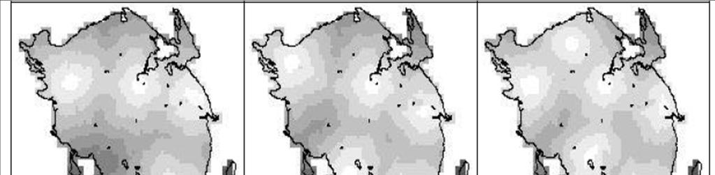
15 GIS data include: a road network demographic data ambulance duties accidents and Falckresources (number of vehicles, garages etc

16 Working with Data: Layers :features as road network accidents Outline In figure 1 Falck garages on top 2 road network with speed limits above 70 km/h at the bottom
17 Data The major elements of data include Accidents: Include Time of the call Time of ambulance reaches the accident Time when the ambulance is available again. Road Network One way street speed limits Travel time Information about which addresses belong to which road

18 Accident Analysis There are two items contract with accidents Where and when happen Use periodic time Analysis: Increase in towns Percentage of accidents in summer weekend differ from that in winter weekend

19 Accidents rate: Time By days Observes; The highest number of accident on Friday The smallest number of accident on Sunday


20 Accidents rate By month December has a large number of accidents
21 The lowest number of accidents happen when people are at sleep. The highest number of accidents happen between 9 am and 2 pm in the weekdays when people are at work.


22 Best Results for allocation of ambulances on Funen

23
24 Framework of GIS
25 The GUI helps the users to interact with GIS environment features Mapping enable planners and to preprocess data, identify and visualise problems easily. planners can better target when, where, and for what type of calls ambulance response performance must be improved
26 practical For Improving Response: Conducted in Mecklenburg County Done by MEDIC To get to an incident location.use GIS software GPS mobile computers
27 Improving Response Implementation an ambulance is dispatched to a call, the system displays information about the call It suggests a route that is based on shortest travel time. choose a hospital from a list, and the system routes them to that hospital Results This system has reduced overall response times by 15 percent

28
29 Conclusion Health care is an important part. It has many application systems, planning and services. These application need to improve by using specific technological tools, one of these tools called GIS. Emergency medical service one of these health application that need to improve by GIS especially emergency vehicles. The described GIS structure can assess emergency vehicles performance and help in minimizing the response time.
30 Conclusion GIS plays an important role in determining the best location for emergency vehicles to be located
31
Background of Project
 RELOCATION OF GRESHAM FIRE STATION #76 Mike Shelby Annie Scriven Andrea Consalus Background of Project Wanted to do a project that was meaningful Contacted Molly Vogt, GIS Manager at City of Gresham Informed
QUANTIFICATION OF THE NATURAL VARIATION IN TRAFFIC FLOW ON SELECTED NATIONAL ROADS IN SOUTH AFRICA
 QUANTIFICATION OF THE NATURAL VARIATION IN TRAFFIC FLOW ON SELECTED NATIONAL ROADS IN SOUTH AFRICA F DE JONGH and M BRUWER* AECOM, Waterside Place, Tygerwaterfront, Carl Cronje Drive, Cape Town, South
Mountain View Community Shuttle Monthly Operations Report
 Mountain View Community Shuttle Monthly Operations Report October 9, 2018 Contents Passengers per Day, Table...- 3 - Passengers per Day, Chart...- 3 - Ridership Year-To-Date...- 4 - Average Daily Ridership
Neighborhood Locations and Amenities
 University of Maryland School of Architecture, Planning and Preservation Fall, 2014 Neighborhood Locations and Amenities Authors: Cole Greene Jacob Johnson Maha Tariq Under the Supervision of: Dr. Chao
City of Saginaw Right of Way Division Snow and Ice Removal Policy January 18, 2016
 Snow and Ice Removal Policy January 18, 2016 It is the policy of the to provide snowplowing and ice removal services in order to: Provide safe traveling conditions for motorists and pedestrians Assist
VHD Daily Totals. Population 14.5% change. VMT Daily Totals Suffolk 24-hour VMT. 49.3% change. 14.4% change VMT
 6.9 Suffolk 6-54 VMT Population and Travel Characteristics Population 14.5% change 2014 1,529,202 VHD Daily Totals 2014 251,060 49.3% change 2040 1,788,175 2040 374,850 VMT Daily Totals 2014 39,731,990
Snow Removal Winchester Department of Public Works
 Snow Removal Winchester Department of Public Works Town of Winchester Board of Selectmen Meeting Neil H. Amwake, P.E. November 4, 2013 Presentation Outline Goals and Objectives 1. Connecticut snowfall
NETWORK ANALYSIS FOR URBAN EMERGENCY SERVICES IN SOLAPUR CITY, INDIA: A GEOINFORMATIC APPROACH
 NETWORK ANALYSIS FOR URBAN EMERGENCY SERVICES IN SOLAPUR CITY, INDIA: A GEOINFORMATIC APPROACH Sagar P. Mali * & Yogesh A. Mane ** * Research Student, Department of Geography, Shivaji University, Kolhapur,
LOCATION OF PREHOSPITAL CARE BASIS THROUGH COMBINED FUZZY AHP AND GIS METHOD
 ISAHP Article: Mu, Saaty/A Style Guide for Paper Proposals To Be Submitted to the LOCATION OF PREHOSPITAL CARE BASIS THROUGH COMBINED FUZZY AHP AND GIS METHOD Marco Tiznado Departamento de Ingeniería Industrial,
KENTUCKY HAZARD MITIGATION PLAN RISK ASSESSMENT
 KENTUCKY HAZARD MITIGATION PLAN RISK ASSESSMENT Presentation Outline Development of the 2013 State Hazard Mitigation Plan Risk Assessment Determining risk assessment scale Census Data Aggregation Levels
CITY OF NEW LONDON WINTER ROAD & SIDEWALK MAINTENANCE POLICY
 CITY OF NEW LONDON WINTER ROAD & SIDEWALK MAINTENANCE POLICY GENERAL The purpose of this policy is to set up acceptable procedures and policies for the winter maintenance of public areas in the City of
Sensitivity of estimates of travel distance and travel time to street network data quality
 Sensitivity of estimates of travel distance and travel time to street network data quality Paul Zandbergen Department of Geography University of New Mexico Outline Street network quality Approaches to
SPACE-TIME ACCESSIBILITY MEASURES FOR EVALUATING MOBILITY-RELATED SOCIAL EXCLUSION OF THE ELDERLY
 SPACE-TIME ACCESSIBILITY MEASURES FOR EVALUATING MOBILITY-RELATED SOCIAL EXCLUSION OF THE ELDERLY Izumiyama, Hiroshi Institute of Environmental Studies, The University of Tokyo, Tokyo, Japan Email: izumiyama@ut.t.u-tokyo.ac.jp
3. If a forecast is too high when compared to an actual outcome, will that forecast error be positive or negative?
 1. Does a moving average forecast become more or less responsive to changes in a data series when more data points are included in the average? 2. Does an exponential smoothing forecast become more or
TOWN OF JAMESTOWN TOWN COUNCIL RECOMMENDED BUDGET 2014/2015
 70001.000 COUNCIL GENERAL GOVERNMENT.101 Salaries (5) 10,455.62 11,300.00 11,300.00 11,300.00 11,300.00.302 Fees & Supplies 632.78 1,500.00 1,500.00 1,500.00 1,500.00.305 Advertising 0.00 2,500.00 2,500.00
Modeling evacuation plan problems
 Chapter 7 Modeling evacuation plan problems In Section 3.1 we reviewed the recommendations that the UNESCO presented in [30] to develop volcanic emergency plans. In [18] is presented the state of art of
What is GIS? ESRI Canada. August 2011
 What is GIS? ESRI Canada August 2011 Geography Matters! Environmental Park Management Agriculture Public Utilities Health Care Emergency 911 Real Estate Marketing Environmental What are the effects of
Applications of GIS in Electrical Power System. Dr. Baqer AL-Ramadan Abdulrahman Al-Sakkaf
 Applications of GIS in Electrical Power System Dr. Baqer AL-Ramadan Abdulrahman Al-Sakkaf OUTLINES: Objective Importance of GIS GIS data development Application of GIS Findings Conclusions and Recommendations
Purpose Study conducted to determine the needs of the health care workforce related to GIS use, incorporation and training.
 GIS and Health Care: Educational Needs Assessment Cindy Gotz, MPH, CHES Janice Frates, Ph.D. Suzanne Wechsler, Ph.D. Departments of Health Care Administration & Geography California State University Long
Using GIS to Brief New York City Public Officials after September 11
 Using GIS to Brief New York City Public Officials after September 11 Presented by Zvia Segal Naphtali, Ph.D. and Leonard M. Naphtali, Ph.D. Presented at the ESRI International Health GIS Conference, May
Mountain View Community Shuttle Monthly Operations Report
 Mountain View Community Shuttle Monthly Operations Report December 6, 2018 Contents Passengers per Day, Table...- 3 - Passengers per Day, Chart...- 3 - Ridership Year-To-Date...- 4 - Average Daily Ridership
Applying Health Outcome Data to Improve Health Equity
 Applying Health Outcome Data to Improve Health Equity Devon Williford, MPH, Health GIS Specialist Lorraine Dixon-Jones, Policy Analyst CDPHE Health Equity and Environmental Justice Collaborative Mile High
COUNCIL POLICY MANUAL
 COUNCIL POLICY MANUAL SECTION: PUBLIC WORKS SUBJECT: SNOW & ICE CONTROL POLICY 2012/2013 GOAL: Pages: 1 of 10 Approval Date: Dec. 3, 2012 Res. # 1001/2012 To annually identify the winter maintenance costs
Establishing Winter Standard Operating Procedures
 Establishing Winter Standard Operating Procedures Achieving Consistency (Or how to do your job without getting canned!) Presenter: Chip Porter, P.E. Highway Engineer St. Joseph County Dept. of Public Works
A GIS BASED NETWORK ANALYSIS FOR THE IDENTIFICATION OF SHORTEST ROUTE ACCESS TO EMERGENCY MEDICAL FACILITIES
 Geographia Technica, Vol. 09, Issue 2, 2014, pp 60 to 67 A GIS BASED NETWORK ANALYSIS FOR THE IDENTIFICATION OF SHORTEST ROUTE ACCESS TO EMERGENCY MEDICAL FACILITIES Paul-Silviu NICOARĂ 1, Ionel HAIDU
Emergency Traffic Management In the Case of Severe Winter Conditioins
 Emergency Traffic Management In the Case of Severe Winter Conditioins Presentation on the Project Workshop Organizing Emergency Management Strategies for the Transport Sector with the Use of innovative
Spatial multicriteria analysis for home buyers
 Spatial multicriteria analysis for home buyers Xavier Albacete University of Eastern Finland, Department of Environmental Science, Research Group of Environmental Informatics, Yliopistoranta 1 E, P.O.
Using GIS to Evaluate Rural Emergency Medical Services (EMS)
") Using GIS to Evaluate Rural Emergency Medical Services (EMS) Zhaoxiang He Graduate Research Assistant Xiao Qin Ph.D., P.E. Associate Professor Outline Introduction Literature Review Study Design Data Collection
Using GIS to Evaluate Rural Emergency Medical Services (EMS) Zhaoxiang He Graduate Research Assistant Xiao Qin Ph.D., P.E. Associate Professor Outline Introduction Literature Review Study Design Data Collection
The Role of GIS in Information System, Management and Decision Making in Hospitals and Ambulance Centers
 The Role of GIS in Information System, Management and Decision Making in Hospitals and Ambulance Centers Sareh Aminzadeh 1, Mohammad Rabiee 2, Yousef Rezaei 3, Mostafa Bahman-Abadi 4 1 MSc of Medical Information
Town of Barnstable. Department of Public Work. Snow and Ice Control Operations Plan
 Town of Barnstable Department of Public Work Snow and Ice Control Operations Plan I. Mission: The mission of the Department of Public Works is to remove accumulations of snow and ice from town, county
GIS at the Regional District
 GIS at the Regional District Amanda Spendiff Outline Introduction What is a Regional District? Our GIS department What does the GIS department do? Data management & mapping 9-1-1 fire/dispatch support
Medical GIS: New Uses of Mapping Technology in Public Health. Peter Hayward, PhD Department of Geography SUNY College at Oneonta
 Medical GIS: New Uses of Mapping Technology in Public Health Peter Hayward, PhD Department of Geography SUNY College at Oneonta Invited research seminar presentation at Bassett Healthcare. Cooperstown,
PW 001 SNOW REMOVAL AND SANDING FOR ROADWAYS AND SIDEWALKS October 6, 2014 (#223-14) Original October 19, 2015; October 15, 2018 Public Works
 Original October 19, 2015; October 15, 2018 Public Works") Policy Statement: The Village of Kitscoty will provide snow and ice control on municipal streets and sidewalks according to determined priorities. Purpose: To provide direction and information to employees
Policy Statement: The Village of Kitscoty will provide snow and ice control on municipal streets and sidewalks according to determined priorities. Purpose: To provide direction and information to employees
GIS ANALYSIS METHODOLOGY
 GIS ANALYSIS METHODOLOGY No longer the exclusive domain of cartographers, computer-assisted drawing technicians, mainframes, and workstations, geographic information system (GIS) mapping has migrated to
Section III: Poverty Mapping Results
 Section III: Poverty Mapping Results Figure 5: Gewog level rural poverty map 58. The most prominent result from the poverty mapping exercise of Bhutan is the production of a disaggregated poverty headcount
The Tampa Bay Catastrophic Plan Presentation to CFGIS Users Group FDOT District 5 Urban Offices - Orlando July 30, 2010
 The Tampa Bay Catastrophic Plan Presentation to CFGIS Users Group FDOT District 5 Urban Offices - Orlando July 30, 2010 Brady Smith Senior Planner Tampa Bay Regional Planning Council Introduction Recent
CITY OF RIVERSIDE USING HAZUS TO CREATE A EARTHQUAKE PLANNING GUIDE FOR A UNIFIED FIELD RESPONSE
 CITY OF RIVERSIDE USING HAZUS TO CREATE A EARTHQUAKE PLANNING GUIDE FOR A UNIFIED FIELD RESPONSE Presented by the Phil McCormick City of Riverside Office of Emergency Management HISTORY The City had several
Economic consequences of floods: impacts in urban areas
 Economic consequences of floods: impacts in urban areas SWITCH Paris Conference Paris, 24 th 26 th January 2011 Economic consequences of floods: impacts in urban areas Institutions: Authors Vanessa Cançado
Frequently Asked Questions
 What is the Regional Transit Engagement Series? As one of the fastest growing regions in the country, there is recognition that long-term transit planning efforts should be accelerated if we are to remain
Accessibility analysis of multimodal transport systems using advanced GIS techniques
 Urban Transport XIII: Urban Transport and the Environment in the 21st Century 655 Accessibility analysis of multimodal transport systems using advanced GIS techniques T. Vorraa Citilabs Regional Director,
The Road to Improving your GIS Data. An ebook by Geo-Comm, Inc.
 The Road to Improving your GIS Data An ebook by Geo-Comm, Inc. An individual observes another person that appears to be in need of emergency assistance and makes the decision to place a call to 9-1-1.
Health GIS Tools and Applications Informing Decisions in Yemen
 Health GIS Tools and Applications Informing Decisions in Yemen Prepared by: Carleen Ghio 1, Mark Landry 1, Abdulkadir Nueman 2, and Ahmed Attieg 3 Presented at: Map Middle East Conference April 23-25,
Appendix BAL Baltimore, Maryland 2003 Annual Report on Freeway Mobility and Reliability
 (http://mobility.tamu.edu/mmp) Office of Operations, Federal Highway Administration Appendix BAL Baltimore, Maryland 2003 Annual Report on Freeway Mobility and Reliability This report is a supplement to:
Montmorency County Traffic Crash Data & Year Trends. Reporting Criteria
 June 2018 Revised 8/3/2018 2017 Reporting Criteria Please pay particular attention to the wording when interpreting the three levels of data gathered for this report. Crash The Crash Level analyzes data
OPERATIONAL PERFORMANCE STANDARDS: DECEMBER 2008
 AGENDA ITEM No. 5 MEETING : TRUST BOARD DATE : 4 FEBRUARY 2009 REPORT OF : INTERIM DIRECTOR OF AMBULANCE SERVICES/DIRECTOR OF ICT Contact : David Jackland, Officer Tel: 01745 532936 Email: Ceryl.Jones@ambulance.wales.nhs.uk
City of Hermosa Beach Beach Access and Parking Study. Submitted by. 600 Wilshire Blvd., Suite 1050 Los Angeles, CA
 City of Hermosa Beach Beach Access and Parking Study Submitted by 600 Wilshire Blvd., Suite 1050 Los Angeles, CA 90017 213.261.3050 January 2015 TABLE OF CONTENTS Introduction to the Beach Access and Parking
Transport Planning in Large Scale Housing Developments. David Knight
 Transport Planning in Large Scale Housing Developments David Knight Large Scale Housing Developments No longer creating great urban spaces in the UK (Hall 2014) Transport Planning Transport planning processes
The spatial network Streets and public spaces are the where people move, interact and transact
 The spatial network Streets and public spaces are the where people move, interact and transact The spatial network Cities are big spatial networks that create more of these opportunities Five key discoveries
Crime Analysis. GIS Solutions for Intelligence-Led Policing
 Crime Analysis GIS Solutions for Intelligence-Led Policing Applying GIS Technology to Crime Analysis Know Your Community Analyze Your Crime Use Your Advantage GIS aids crime analysis by Identifying and
Network Analysis with ArcGIS Online. Deelesh Mandloi Dmitry Kudinov
 Deelesh Mandloi Dmitry Kudinov Introductions Who are we? - Network Analyst Product Engineers Who are you? - Network Analyst users? - ArcGIS Online users? - Trying to figure out what is ArcGIS Online? Slides
Designing smart & Resilient cities:
 Designing smart & Resilient cities: How can Egyptian cities learn from an emerging global practice On the Cuspof Change Professor Samer Bagaeen FRICS MRTPI FRSA AoU 1. GLOBAL CHALLENGES POPULATION GROWTH,
Montmorency County Traffic Crash Data & Year Trends. Reporting Criteria
 June 2017 Revised 10/3/17 2016 Reporting Criteria Please pay particular attention to the wording when interpreting the three levels of data gathered for this report. Crash The Crash Level analyzes data
Comprehensive Winter Maintenance Management System BORRMA-web MDSS inside to increase Road Safety and Traffic Flow
 Thorsten Cypra 1 Comprehensive Winter Maintenance Management System BORRMA-web MDSS inside to increase Road Safety and Traffic Flow American Public Works Association (APWA) Monday, 04/14/2008 3:30 4:30
Data driven approaches to Urban Planning Experience from Derry/Londonderry
 Data driven approaches to Urban Planning Experience from Derry/Londonderry Anna Rose RTPI Belfast 11 th of September 1 June 26 07:47AM 2 The value of the City The space of the city is a theatre: playing
FIRE DEPARMENT SANTA CLARA COUNTY
 DEFINITION FIRE DEPARMENT SANTA CLARA COUNTY GEOGRAPHIC INFORMATION SYSTEM (GIS) ANALYST Under the direction of the Information Technology Officer, the GIS Analyst provides geo-spatial strategic planning,
SONOMA COUNTY FIRE TIMELINE. November 1, 2017
 SONOMA COUNTY FIRE TIMELINE November 1, 2017 1 In the late evening of Sunday, October 8, 2017, and the early morning hours of Monday, October 9, 2017, fire swept through the Santa Rosa area including areas
Key Steps for Assessing Mission Critical Data for An ebook by Geo-Comm, Inc.
 Key Steps for Assessing Mission Critical Data for 9-1-1 An ebook by Geo-Comm, Inc. If you re reading this, you probably understand transitioning to Next Generation 9-1-1 (NG9-1-1) means your Geographic
Identifying Gaps in Health Service Provision: GIS Approaches
 Identifying Gaps in Health Service Provision: GIS Approaches Errol Bamford, Graeme Hugo Errol Bamford 6th National Rural Health Conference Canberra, Australian Capital Territory, 4-7 March 2001 Identifying
Hot Calls. Odessa FD: MVA. Burdett FD: MVAs
 Schuyler County Emergenc y M anagement Hot Calls Volume 4, Issue 5 Written by: Rick Churches Send news to: rickshirlc27@gmail.com Odessa FD: MVA September/October 2017 B usy night for OFD as two calls
John Laznik 273 Delaplane Ave Newark, DE (302)
") Office Address: John Laznik 273 Delaplane Ave Newark, DE 19711 (302) 831-0479 Center for Applied Demography and Survey Research College of Human Services, Education and Public Policy University of Delaware
Office Address: John Laznik 273 Delaplane Ave Newark, DE 19711 (302) 831-0479 Center for Applied Demography and Survey Research College of Human Services, Education and Public Policy University of Delaware
UNIVERSITY OF VIRGINIA
 FACILITIES MANAGEMENT UNIVERSITY OF VIRGINIA SNOW AND ICE CONTROL PLAN 2017-2018 Table of Contents Introduction... 2 Snow and Ice Control Objectives... 2 Organization... 2 Director of Operations:... 2
Town of Bowden Province of Alberta Policy Document ( ) SNOW REMOVAL POLICY
 SNOW REMOVAL POLICY") Town of Bowden Box 338, 2101 20 th Ave Bowden, Alberta, T0M 0K0 Town of Bowden Province of Alberta Policy Document (2019-01) SNOW REMOVAL POLICY 1 INTRODUCTION The purpose of this policy is to establish
Town of Bowden Box 338, 2101 20 th Ave Bowden, Alberta, T0M 0K0 Town of Bowden Province of Alberta Policy Document (2019-01) SNOW REMOVAL POLICY 1 INTRODUCTION The purpose of this policy is to establish
Finding Common Ground Through GIS
 Finding Common Ground Through GIS Matthew Stone, MPH Special Unit for Technical Assistance Chronic Disease and Injury Control California Department of Public Health ESRI Health GIS Conference Scottsdale,
SNOW REMOVAL GUIDE. City Of Orange Township. Public Works Snow Removal Hotline: (973) My Orange Hotline: (973)
 My Orange Hotline: (973)") Mayor Dwayne D. Warren, Esq. And The Orange Municipal Council MOVING ORANGE FORWARD City Of Orange Township SNOW REMOVAL GUIDE Public Works Snow Removal Hotline: (973) 266-4030 My Orange Hotline: (973)
Mayor Dwayne D. Warren, Esq. And The Orange Municipal Council MOVING ORANGE FORWARD City Of Orange Township SNOW REMOVAL GUIDE Public Works Snow Removal Hotline: (973) 266-4030 My Orange Hotline: (973)
May 31, Flood Response Overview
 May 31, 2013 Flood Response Overview Suppression 867 Personnel on three (3) shifts 289 Red Shift (A) 289 Blue Shift (B) 289 Green Shift (C) Department Overview Department Overview EMS: 40,934 False Alarm:
Problem: Emergency Medical Response
 Problem: Emergency Medical Response The Emergency Service Coordinator (ESC) for a county is interested in locating the county s three ambulances to best maximize the number of residents that can be reached
ArcGIS for Planning and Data Management at Interior Health Authority. Brent Harris, GIS Analyst Information Management
 ArcGIS for Planning and Data Management at Interior Health Authority Brent Harris, GIS Analyst Information Management About Interior Health 1 of 5 geographically-based Health Authorities in B.C. ~215,000
Holistic Planning for Urban & Rural Health Care Infrastructure: A Case Study for a District in India
 Holistic Planning for Urban & Rural Health Care Infrastructure: A Case Study for a District in India Sanjay Sinha 1, Priyanka Sharma 2 1 Knowledge Expert (Geo Analytics), Boston Consulting Group 2 Senior
ESRI INTERNATIONAL USER CONFERENCE July 11 15, 2011 San Diego, CA - USA. Spatial analysis of health facilities in Yola, Nigeria, using GIS
 ESRI INTERNATIONAL USER CONFERENCE July 11 15, 2011 San Diego, CA - USA Spatial analysis of health facilities in Yola, Nigeria, using GIS Abdurrahman Belel ISMAILA 1 belelismaila@yahoo.com Nurünnisa USUL
Your web browser (Safari 7) is out of date. For more security, comfort and. the best experience on this site: Update your browser Ignore
 is out of date. For more security, comfort and. the best experience on this site: Update your browser Ignore") Your web browser (Safari 7) is out of date. For more security, comfort and Activityengage the best experience on this site: Update your browser Ignore Introduction to GIS What is a geographic information
Your web browser (Safari 7) is out of date. For more security, comfort and Activityengage the best experience on this site: Update your browser Ignore Introduction to GIS What is a geographic information
Diagnosing New York City s Noises with Ubiquitous Data
 Diagnosing New York City s Noises with Ubiquitous Data Dr. Yu Zheng yuzheng@microsoft.com Lead Researcher, Microsoft Research Chair Professor at Shanghai Jiao Tong University Background Many cities suffer
Designing Service Coverage and Measuring Accessibility and Serviceability of Rural and Small Urban Ambulance Systems
 Systems 2014, 2, 34-53; doi:10.3390/systems2010034 Article OPEN ACCESS systems ISSN 2079-8954 www.mdpi.com/journal/systems Designing Service Coverage and Measuring Accessibility and Serviceability of Rural
Integrating GIS into West Nile Virus Planning and Surveillance
 Integrating GIS into West Nile Virus Planning and Surveillance Fairfax County Health Department Adrian Joye, Environmental Health Specialist Agenda Background/Benefits Routes/Trap Locations Dead Bird Complaint
Table-Top Exercise for Emergency Preparedness Evaluation: Little Anse, Isle Madame
 Table-Top Exercise for Emergency Preparedness Evaluation: Little Anse, Isle Madame Alexander Chung, M.Sc. Candidate C-Change Student Research Associate May 2013 The Community of Little Anse Coastal community
Smart Eco-path Finder for Mobile GIS Users
 Smart Eco-path Finder for Mobile GIS Users Dr. Ko Ko Lwin and Prof. Yuji Murayama Graduate School of Life and Environmental Sciences Objective Remote Sensing Urban Green Space Walkability Spatial WEB Technology
Introduction to GIS. Dr. M.S. Ganesh Prasad
 Introduction to GIS Dr. M.S. Ganesh Prasad Department of Civil Engineering The National Institute of Engineering, MYSORE ganeshprasad.nie@gmail.com 9449153758 Geographic Information System (GIS) Information
Accessibility as an Instrument in Planning Practice. Derek Halden DHC 2 Dean Path, Edinburgh EH4 3BA
 Accessibility as an Instrument in Planning Practice Derek Halden DHC 2 Dean Path, Edinburgh EH4 3BA derek.halden@dhc1.co.uk www.dhc1.co.uk Theory to practice a starting point Shared goals for access to
City of Scottsbluff, Nebraska Monday, July 16, 2018 Regular Meeting
 City of Scottsbluff, Nebraska Monday, July 16, 2018 Regular Meeting Item Finance1 Council to receive the 2018 Financial Report. Staff Contact: Liz Hilyard, Finance Director Scottsbluff Regular Meeting
ICE STORM! Emergency Preparedness Exercise February 20, 2008
 ICE STORM! Emergency Preparedness Exercise February 20, 2008 Exercise Objectives 1. To identify issues to consider when planning for an ice storm emergency. 2. To encourage development of an operational
WOODRUFF ROAD CORRIDOR ORIGIN-DESTINATION ANALYSIS
 2018 WOODRUFF ROAD CORRIDOR ORIGIN-DESTINATION ANALYSIS Introduction Woodruff Road is the main road to and through the commercial area in Greenville, South Carolina. Businesses along the corridor have
Residents Emergency Response Checklist
 COMMUNITY RESILIENCE PLAN Residents Emergency Response Checklist A helpful guide in the event of extreme weather or bushfire events. < PREVIOUS I NEXT > 02 Purchasing an existing property or building a
How GIS based Visualizations Support Land Use and Transportation Modeling
 How GIS based Visualizations Support Land Use and Transportation Modeling ESRI International Users Conference San Diego, CA - July 23, 2015 Prepared by: Troy Hightower Introduction This presentation will
SNOW REMOVAL POLICY ITASCA COUNTY TRANSPORTATION DEPARTMENT
 ITASCA COUNTY TRANSPORTATION DEPARTMENT Effective Date: November 1, 1989 Revised: November 18, 2014 Policy Number: Operations 89-4 Distribution: Commissioner's Office Engineer's Office All Garages Number
Measurement of human activity using velocity GPS data obtained from mobile phones
 Measurement of human activity using velocity GPS data obtained from mobile phones Yasuko Kawahata 1 Takayuki Mizuno 2 and Akira Ishii 3 1 Graduate School of Information Science and Technology, The University
Changes in the Spatial Distribution of Mobile Source Emissions due to the Interactions between Land-use and Regional Transportation Systems
 Changes in the Spatial Distribution of Mobile Source Emissions due to the Interactions between Land-use and Regional Transportation Systems A Framework for Analysis Urban Transportation Center University
Local government of El Prat de Llobregat is working with the Metropolitan Area of Barcelona teamwork on resilience to climate change
 Local government of El Prat de Llobregat is working with the Metropolitan Area of Barcelona teamwork on resilience to climate change Adaptation plan to climate change at AMB Barcelona, resilient city on
Transit Time Shed Analyzing Accessibility to Employment and Services
 Transit Time Shed Analyzing Accessibility to Employment and Services presented by Ammar Naji, Liz Thompson and Abdulnaser Arafat Shimberg Center for Housing Studies at the University of Florida www.shimberg.ufl.edu
MANAGING TRANSPORTATION & LAND USE INTERACTIONS (PL-58)
") MANAGING TRANSPORTATION & LAND USE INTERACTIONS (PL-58) COURSE OUTLINE DAY ONE 1:30 2:00 p.m. MODULE 1: History and Context Understand history and foundation for transportation and land use planning today
MANAGING TRANSPORTATION & LAND USE INTERACTIONS (PL-58) COURSE OUTLINE DAY ONE 1:30 2:00 p.m. MODULE 1: History and Context Understand history and foundation for transportation and land use planning today
The Leader in Landscape Solutions
 The Leader in Landscape Solutions Emergency Action Plan Hurricane Preparedness Go To Mainscape.com For More Information! Purpose: To provide the Federation at Kings Point and their residents an informative
Snow and Ice Control POLICY NO. P-01/2015. CITY OF AIRDRIE Snow and Ice Control Policy
 Page 1 CITY OF AIRDRIE Snow and Ice Control Effective Date: Approved By: Approved On: March 17, 2015 City Council March 16, 2015 Revision Date: Resolution #: ------ PURPOSE: The City of Airdrie is responsible
CITY OF EAST PEORIA SNOW AND ICE CONTROL PROGRAM INTRODUCTION
 CITY OF EAST PEORIA SNOW AND ICE CONTROL PROGRAM INTRODUCTION The responsibility for providing snow and ice control on East Peoria s 240 lane miles of streets and alleys rests with the Street Divisions
Integrating Origin and Destination (OD) Study into GIS in Support of LIRR Services and Network Improvements
 Study into GIS in Support of LIRR Services and Network Improvements") Integrating Origin and Destination (OD) Study into GIS in Support of LIRR Services and Network Improvements GIS In Transit Conference, Washington, DC Long Island Rail Road Pyung ho Kim Date: September
Integrating Origin and Destination (OD) Study into GIS in Support of LIRR Services and Network Improvements GIS In Transit Conference, Washington, DC Long Island Rail Road Pyung ho Kim Date: September
Assessment and management of at risk populations using a novel GIS based UK population database tool
 Safety and Security Engineering 203 Assessment and management of at risk populations using a novel GIS based UK population database tool H. Balmforth 1, H. McManus 1 & A. Fowler 2 1 Health and Safety Laboratory,
Modelling Accessibility to General Hospitals in Ireland
 Modelling Accessibility to General Hospitals in Ireland Stamatis Kalogirou 1,*, Ronan Foley 2 1. National Centre for Geocomputation, John Hume Building, NUI Maynooth, Maynooth, Co. Kildare, Ireland, Tel:
WINTER MAINTENANCE MANAGEMENT IN ESTONIA. Kuno Männik Director of Tartu Road Office Estonian Road Administration
 WINTER MAINTENANCE MANAGEMENT IN ESTONIA Kuno Männik Director of Tartu Road Office Estonian Road Administration Kuno.Mannik@tartutv.mnt.ee Location Estonia is a small northern member-state of the European
Winter Weather. National Weather Service Buffalo, NY
 Winter Weather National Weather Service Buffalo, NY Average Seasonal Snowfall SNOWFALL = BIG IMPACTS School / government / business closures Airport shutdowns/delays Traffic accidents with injuries/fatalities
Project Appraisal Guidelines
 Project Appraisal Guidelines Unit 16.2 Expansion Factors for Short Period Traffic Counts August 2012 Project Appraisal Guidelines Unit 16.2 Expansion Factors for Short Period Traffic Counts Version Date
APPENDIX IV MODELLING
 APPENDIX IV MODELLING Kingston Transportation Master Plan Final Report, July 2004 Appendix IV: Modelling i TABLE OF CONTENTS Page 1.0 INTRODUCTION... 1 2.0 OBJECTIVE... 1 3.0 URBAN TRANSPORTATION MODELLING
BOONE COUNTY Snow Removal Program and Policy SECTION 1, INTRODUCTION:
 BOONE COUNTY Snow Removal Program and Policy SECTION 1, INTRODUCTION: The Roads Department of Boone County is responsible for providing snow removal for approximately 1100 miles of county roads. The Roads
Winter Weather. Naval Station Great Lakes Winter Season
 Winter Weather Naval Station Great Lakes Winter Season 2015-2016 Local Area Information Resources Lake County Passage (local road conditions) https://www.lakecountypassage.com/index.jsp 1620 AM National