CCSG Needs Assessment: Characterizing the cancer burden in our catchment area
|
|
|
- Jodie Black
- 5 years ago
- Views:
Transcription
1 CCSG Needs Assessment: Characterizing the cancer burden in our catchment area Jason A. Mendoza, MD, MPH Associate Director of Minority Health and Health Disparities
2 Pilot Grant on Catchment Area Health Cancer-related pilot projects on cancer health inequities within the catchment area P30 CCSG: Describe how the cancer research relevant to the catchment area is addressed 3 awards $80k direct costs/year/award; F&A included above this amount
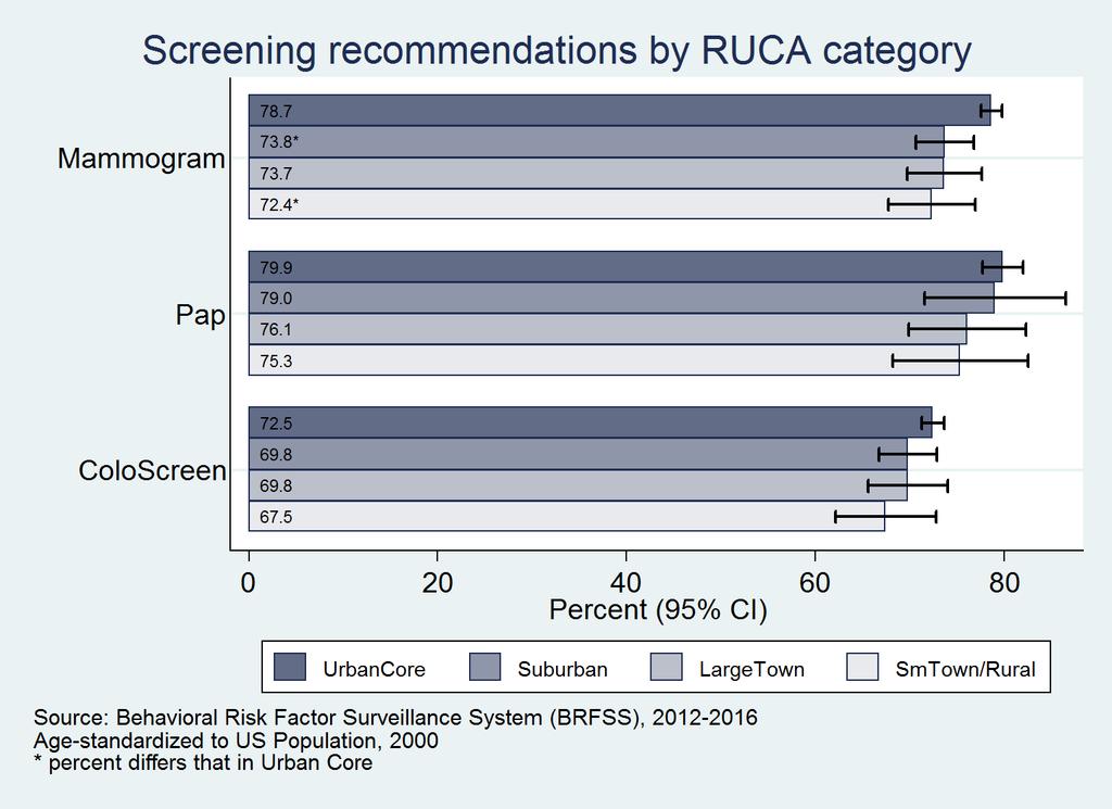
3 Pilot Grant on Catchment Area Health Address one or more of the following topics: Prevention and/or risk-reducing strategies for one of the top 5 cancers (breast, colorectal, lung, prostate, hematologic) Mitigating cancer-related behaviors in communities Aligning communities to meet screening recommendations for breast, cervical, and colorectal cancers Reducing cancer burden in rural communities within the catchment area Increasing enrollment of underserved minorities into Consortium clinical trials
4 Pilot Grant on Catchment Area Health New project or new research direction Provide prelim data for outside funding Not be an extension of on-going or recently funded studies
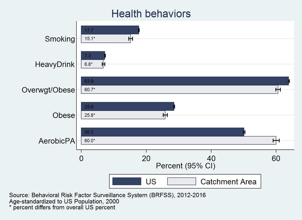
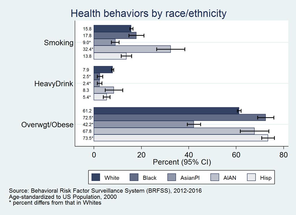
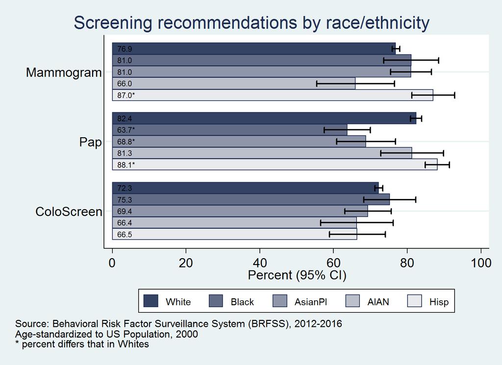
5 NEEDS ASSESSMENT DATA
6 The Cancer Consortium Catchment Area Residents: 4,931,410 Incident Cancer Cases: 27,450 Seattle
7 Demographic Characteristics of the Catchment Area and Clinical Trials 2017 Characteristic U.S. WA State 13-County Catchment Area LAPS data (Clinical Trial Accrual) Race/ethnicity Pop'n (%) Pop'n (%) Pop'n (%) Pop'n (%) NHW 197,969, ,005, ,366, * Black 40,229, , , * Asian 17,741, , , * NHOPI 567, , , AIAN 2,387, , , Hispanic 57,470, , , * Other/multiple 6,762, , , * *Significantly different compared to 13-county Catchment Area, p<0.05

8 Top 5 Cancer Incidence Sites

9 Top 5 Cancer Mortality Sites
10
11 Incidence & Mortality in the Catchment Area by Race/Ethnicity Race/ethnicity U.S. Incidence Rate Catchment Incidence Rate U.S. Mortality Rate Catchment Mortality Rate NHW Black D D Asian/PI D D AIAN D D Hispanic D D Catchment rate above U.S. rate for same race/ethnicity D Race/ethnicity disparity (vs. NHW) within catchment area
12 Incidence Rates, Catchment AIAN U.S. AIAN Catchment Black U.S. Black Catchment Hispanic U.S. Hispanic Catchment NHW U.S NHW Breast D Prostate D Lung 81.3 D D Colorectal 55.5 D Catchment rate above U.S. rate for same race/ethnicity D Race/ethnicity disparity (vs. NHW) within catchment area
13 Mortality Rates, Catchment U.S. Catchment U.S. Catchment U.S. Catchment U.S AIAN AIAN Black Black Hispanic Hispanic NHW NHW Breast 29.3 D D D Prostate D D Lung 58.5 D D Colorectal 20.7 D D D Catchment rate above U.S. rate for same race/ethnicity D Race/ethnicity disparity (vs. NHW) within catchment area

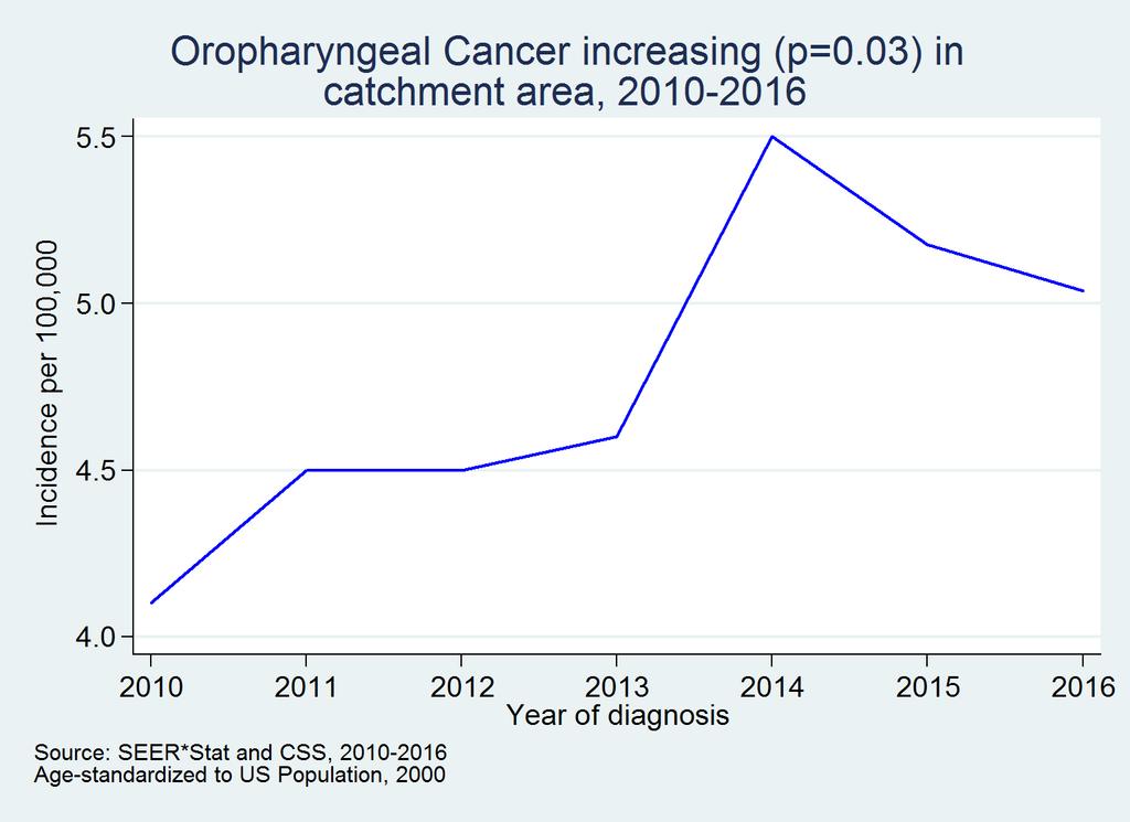
14 Cancer Incidence in Catchment Area ( )

15 Cancer Mortality in Catchment Area ( )
16
17

18 (Cont d)

19
20
21
22 KEY INFORMANT INTERVIEWS THEMES
23 Engaging the vulnerable Needs assessment in catchment area counties to establish greatest cancer needs for underserved Qualitative interviews with: State health department program heads Local county health departments Community-based organizations
24 Barriers - Categories Race/ethnicity crosses all barriers: Issues based on geography Social determinants of health Financial issues Provider issues Partnership/Collaboration issues Race/ethnicity
25 Barriers: Geography Lack of access to care (rural areas) Areas of need with limited resources to address cancer burden affects timeliness of diagnosis & treatment: East of the Cascades (have to travel across counties for care) Olympic peninsula Island counties (entire day to travel to Seattle) Not knowing where to go Transportation challenges; parking cost (urban areas) Weather
26 Barriers: Social determinants of health High unmet needs for rural and low SES populations Stigma Stable housing Food insecurity & lack of access to healthy foods Childcare Adverse Childhood Experiences (ACEs) Health communication: low health literacy lack of culturally & linguistically appropriate materials (and lack of resources among organizations to develop)
27 Barriers: Financial issues Healthcare costs Medicaid (not eligible and can t afford Medicaid expansion) Lack of resources for: Diagnosis (BCCHP limited to breast, cervical, CRC, but other gyn and GI cancers mentioned) Treatment (BCCHP doesn t cover tx for CRC)
28 Barriers: Provider issues Lack of trust in medical system Lack of access in rural areas and islands (untimely followup on screening, diagnosis, treatment) Primary care providers overwhelmed, but they are referral point for screening, vaccination, etc. High staff turnover, especially at FQHCs Complexity of screening guidelines: Not all providers on same page with recommendations Lack of time: Short appointment slots to address symptom/issue at hand Lack of cultural and linguistic competence
29 Barriers: Partnership/Collaboration issues Programs within same organizations working in silos and not aware of each other s work. Lack of knowledge among CBOs about other programs serving same population. Lack of community trust. CBOs want to know how to increase visibility to get the word out about services they offer.
30 Facilitators Patient Navigation & Community Health Workers Partners with established trust in the community Close-knit communities (especially on peninsula) Relationships with health plans Coalitions
31 Perceived role of Cancer Consortium in the catchment area People recognize individual CC entities (FH, SCCA, SC, UW). There is a perception these entities should cover the whole state; lots of resources in 13 counties, less resources and more need outside catchment area. No negative perceptions shared about CC or its entities. People don t know the CC and don t understand what we do. Organizations are interested in collaborating, but need better understanding of what the CC does. It s a time of opportunity!
32 Questions? On behalf of the CCSG Needs Assessment Committee: Steve Schwartz, PhD Dave Doody, MS Peggy Hannon, PhD Caitlin Mason, PhD Wendy Law, PhD Office of Community Outreach and Engagement: Jason Mendoza, MD, MPH, Director Kathy Briant, MPH, CHES, Program Administrator Beti Thompson, PhD, Director Emeritus
Applying Health Outcome Data to Improve Health Equity
 Applying Health Outcome Data to Improve Health Equity Devon Williford, MPH, Health GIS Specialist Lorraine Dixon-Jones, Policy Analyst CDPHE Health Equity and Environmental Justice Collaborative Mile High
Application of Indirect Race/ Ethnicity Data in Quality Metric Analyses
 Background The fifteen wholly-owned health plans under WellPoint, Inc. (WellPoint) historically did not collect data in regard to the race/ethnicity of it members. In order to overcome this lack of data
Supporting the reconfiguration of primary care services: Strategic Health Asset Planning and Evaluation
 Supporting the reconfiguration of primary care services: Strategic Health Asset Planning and Evaluation About SHAPE Strategic Health Asset Planning and Evaluation (SHAPE) is a web enabled, evidence based
Low-Income African American Women's Perceptions of Primary Care Physician Weight Loss Counseling: A Positive Deviance Study
 Thomas Jefferson University Jefferson Digital Commons Master of Public Health Thesis and Capstone Presentations Jefferson College of Population Health 6-25-2015 Low-Income African American Women's Perceptions
Using GIS to Brief New York City Public Officials after September 11
 Using GIS to Brief New York City Public Officials after September 11 Presented by Zvia Segal Naphtali, Ph.D. and Leonard M. Naphtali, Ph.D. Presented at the ESRI International Health GIS Conference, May
The Impacts of the Affordable Care Act on Preventive Services among Racial Groups UNDERGRADUATE RESEARCH THESIS
 The Impacts of the Affordable Care Act on Preventive Services among Racial Groups UNDERGRADUATE RESEARCH THESIS Presented in partial fulfillment of the requirements for the Honors Research Distinction
Social Vulnerability Index. Susan L. Cutter Department of Geography, University of South Carolina
 Social Vulnerability Index Susan L. Cutter Department of Geography, University of South Carolina scutter@sc.edu Great Lakes and St. Lawrence Cities Initiative Webinar December 3, 2014 Vulnerability The
Defining Statistically Significant Spatial Clusters of a Target Population using a Patient-Centered Approach within a GIS
 Defining Statistically Significant Spatial Clusters of a Target Population using a Patient-Centered Approach within a GIS Efforts to Improve Quality of Care Stephen Jones, PhD Bio-statistical Research
Environmental Analysis, Chapter 4 Consequences, and Mitigation
 Environmental Analysis, Chapter 4 4.17 Environmental Justice This section summarizes the potential impacts described in Chapter 3, Transportation Impacts and Mitigation, and other sections of Chapter 4,
Aristithes G. Doumouras BHSc 1, David Gomez MD 1, Barbara Haas MD 1, Donald M. Boyes PhD 2, Avery B. Nathens MD PhD FACS 1,3
 Aristithes G. Doumouras BHSc 1, David Gomez MD 1, Barbara Haas MD 1, Donald M. Boyes PhD 2, Avery B. Nathens MD PhD FACS 1,3 1 Keenan Research Center in the Li Ka Shing Knowledge Institute of St Michael
VBHC, making it happen together. G é r a r d K l o p F o u n d e r & P a r t n e r V i n t u r a M a y 11 th,
 VBHC, making it happen together G é r a r d K l o p F o u n d e r & P a r t n e r V i n t u r a M a y 11 th, 2 0 1 7 1 V i n t u r a i s c o m m i t t e d t o m a k i n g V B H C h a p p e n WHAT WE DO
Purpose Study conducted to determine the needs of the health care workforce related to GIS use, incorporation and training.
 GIS and Health Care: Educational Needs Assessment Cindy Gotz, MPH, CHES Janice Frates, Ph.D. Suzanne Wechsler, Ph.D. Departments of Health Care Administration & Geography California State University Long
STAFF REPORT ACTION REQUIRED. Extreme Cold Weather Alerts in Toronto SUMMARY. Date: April 13, Board of Health. To: Medical Officer of Health
 HL3.6 STAFF REPORT ACTION REQUIRED Extreme Cold Weather Alerts in Toronto Date: April 13, 2015 To: From: Wards: Board of Health Medical Officer of Health All Reference Number: SUMMARY Cold weather can
A Comparison of Collaborative Stage with UICC TNM. Darlene Dale Head, Princess Margaret Cancer Registry June 11, 2013
 A Comparison of Collaborative Stage with UICC TNM Darlene Dale Head, Princess Margaret Cancer Registry June 11, 2013 Outline Background Current Process Rationale for the Comparison Methods Results Conclusions
Medical GIS: New Uses of Mapping Technology in Public Health. Peter Hayward, PhD Department of Geography SUNY College at Oneonta
 Medical GIS: New Uses of Mapping Technology in Public Health Peter Hayward, PhD Department of Geography SUNY College at Oneonta Invited research seminar presentation at Bassett Healthcare. Cooperstown,
Analyzing the Geospatial Rates of the Primary Care Physician Labor Supply in the Contiguous United States
 Analyzing the Geospatial Rates of the Primary Care Physician Labor Supply in the Contiguous United States By Russ Frith Advisor: Dr. Raid Amin University of W. Florida Capstone Project in Statistics April,
Regional Growth Strategy Regional Staff Committee
 Regional Growth Strategy Regional Staff Committee June 21, 2018 1 Overview Summary of June Growth Management Policy Board Regional Growth Strategy Objectives Regional Geographies Regional Growth Strategy
Council Workshop on Neighbourhoods Thursday, October 4 th, :00 to 4:00 p.m. Burlington Performing Arts Centre
 Council Workshop on Neighbourhoods Thursday, October 4 th, 2012 1:00 to 4:00 p.m. Burlington Performing Arts Centre Agenda Introductions Warm-Up Exercise Presentation Exercise Neighbourhood Planning Break
International Journal of Computing and Business Research (IJCBR) ISSN (Online) : APPLICATION OF GIS IN HEALTHCARE MANAGEMENT
 ISSN (Online) : APPLICATION OF GIS IN HEALTHCARE MANAGEMENT") International Journal of Computing and Business Research (IJCBR) ISSN (Online) : 2229-6166 Volume 3 Issue 2 May 2012 APPLICATION OF GIS IN HEALTHCARE MANAGEMENT Dr. Ram Shukla, Faculty (Operations Area),
International Journal of Computing and Business Research (IJCBR) ISSN (Online) : 2229-6166 Volume 3 Issue 2 May 2012 APPLICATION OF GIS IN HEALTHCARE MANAGEMENT Dr. Ram Shukla, Faculty (Operations Area),
Barnabas Chipindu, Department of Physics, University of Zimbabwe
 DEFICIENCIES IN THE OPERATIONAL APPLICATIONS OF LONG - RANGE WEATHER PREDICTIONS FOR AGRICULTURE - RECOMMENDATIONS FOR IMPROVING THE TECHNOLOGY FOR THE BENEFIT OF AGRICULTURE AT THE NATIONAL AND REGIONAL
Group: Leaders of Registered Student Organizations. SPT Partners: Dr. Robbie Steward and Dr. Adam Peck
 Engagement and Data Gathering Sessions Group: Leaders of Registered Student Organizations SPT Partners: Dr. Robbie Steward and Dr. Adam Peck Date: October 6, 2014 Design: S.W.O.T. Carousel Attendees: 50
Measuring community health outcomes: New approaches for public health services research
 Research Brief March 2015 Measuring community health outcomes: New approaches for public health services research P ublic Health agencies are increasingly asked to do more with less. Tough economic times
Policy Paper Alabama Primary Care Service Areas
 Aim and Purpose Policy Paper Alabama Primary Care Service Areas Produced by the Office for Family Health Education & Research, UAB School of Medicine To create primary care rational service areas (PCSA)
BIG IDEAS. Area of Learning: SOCIAL STUDIES Urban Studies Grade 12. Learning Standards. Curricular Competencies
 Area of Learning: SOCIAL STUDIES Urban Studies Grade 12 BIG IDEAS Urbanization is a critical force that shapes both human life and the planet. The historical development of cities has been shaped by geographic,
The purpose of this report is to recommend a Geographic Information System (GIS) Strategy for the Town of Richmond Hill.
 Strategy for the Town of Richmond Hill.") Staff Report for Committee of the Whole Meeting Department: Division: Subject: Office of the Chief Administrative Officer Strategic Initiatives SRCAO.18.12 GIS Strategy Purpose: The purpose of this report
Staff Report for Committee of the Whole Meeting Department: Division: Subject: Office of the Chief Administrative Officer Strategic Initiatives SRCAO.18.12 GIS Strategy Purpose: The purpose of this report
Community Inclusion in Colorado
 A Mapping Project for Emergency Preparedness and Response Aimee Voth Siebert, MA Julia Beems, MA Rachel Coles, MA Devon Williford, MPH Adam Anderson, MURP, MPH March 2015 understanding that HUMAN ENERGY
NEW YORK AND CONNECTICUT SUSTAINABLE COMMUNITIES. Fair Housing & Equity Assessment & Regional Planning Enhancement
 NEW YORK AND CONNECTICUT SUSTAINABLE COMMUNITIES Fair Housing & Equity Assessment & Regional Planning Enhancement November 19, 2013 White Plains Public Library Federal grant to improve regional planning
Long Island Breast Cancer Study and the GIS-H (Health)
") Long Island Breast Cancer Study and the GIS-H (Health) Edward J. Trapido, Sc.D. Associate Director Epidemiology and Genetics Research Program, DCCPS/NCI COMPREHENSIVE APPROACHES TO CANCER CONTROL September,
Long Island Breast Cancer Study and the GIS-H (Health) Edward J. Trapido, Sc.D. Associate Director Epidemiology and Genetics Research Program, DCCPS/NCI COMPREHENSIVE APPROACHES TO CANCER CONTROL September,
A Framework for the Study of Urban Health. Abdullah Baqui, DrPH, MPH, MBBS Johns Hopkins University
 This work is licensed under a Creative Commons Attribution-NonCommercial-ShareAlike License. Your use of this material constitutes acceptance of that license and the conditions of use of materials on this
An introduction to thee Urban Oases Site Selection Tool:
 An introduction to thee Urban Oases Site Selection Tool: Created by Audubon Connecticut with assistance from a GIS Consultant/Research Assistant at the Harvard Forest Essential input provided by the New
Application of Geographic Information Systems and Asset Mapping to Facilitate Identification of Colorectal Cancer Screening Resources
 Application of Geographic Information Systems and Asset Mapping to Facilitate Identification of Colorectal Cancer Screening Resources Clement Kudzai Gwede 1, Beverly G Ward 2, John S Luque 3, Susan T Vadaparampil
Rural Pennsylvania: Where Is It Anyway? A Compendium of the Definitions of Rural and Rationale for Their Use
 Rural Pennsylvania: Where Is It Anyway? A Compendium of the Definitions of Rural and Rationale for Their Use Pennsylvania Office of Rural Health 310 Nursing Sciences Building University Park, PA 16802
Committee Meeting November 6, 2018
 Committee Meeting November 6, 2018 Agenda Where we are in the process Land Use Plan Transportation Element Housing & Neighborhoods Elements Next Steps Schedule November 6: Plan Elements December: Plan
Victorian Liveability Indicator Program: Definition, Measurement and Application
 Victorian Liveability Indicator Program: Definition, Measurement and Application Dr Hannah Badland Senior Research Fellow Place, Health, and Liveability Program Melbourne School of Population and Global
GOVERNMENT MAPPING WORKSHOP RECOVER Edmonton s Urban Wellness Plan Mapping Workshop December 4, 2017
 GOVERNMENT MAPPING WORKSHOP 12.4.17 RECOVER Edmonton s Urban Wellness Plan Mapping Workshop December 4, 2017 In July of 2017, City Council directed administration to develop RECOVER, Edmonton s Urban Wellness
DC: Bridging the Data Divide
 DC: Bridging the Data Divide E S T A B L I S H I N G A D A T A S H A R I N G A G R E E M E N T B E T W E E N T H E S C H O O L S, H E A L T H D E P A R T M E N T, A N D M E D I C A I D T O I M P R O V
The CRP stresses a number of factors that point to both our changing demographics and our future opportunities with recommendations for:
 Plan Overview The CRP represents the first broad planning initiative covering Lake, Porter and LaPorte counties. Unlike previous plans released by NIRPC, which focused primarily on transportation, the
JOINT STRATEGIC NEEDS ASSESSMENT (JSNA) Key findings from the Leicestershire JSNA and Charnwood summary
 Key findings from the Leicestershire JSNA and Charnwood summary") JOINT STRATEGIC NEEDS ASSESSMENT (JSNA) Key findings from the Leicestershire JSNA and Charnwood summary 1 What is a JSNA? Joint Strategic Needs Assessment (JSNA) identifies the big picture in terms of
JOINT STRATEGIC NEEDS ASSESSMENT (JSNA) Key findings from the Leicestershire JSNA and Charnwood summary 1 What is a JSNA? Joint Strategic Needs Assessment (JSNA) identifies the big picture in terms of
Integrating GIS into Food Access Analysis
 GIS Day at Kansas University Integrating GIS into Food Access Analysis Daoqin Tong School of Geography and Development Outline Introduction Research questions Method Results Discussion Introduction Food
This report details analyses and methodologies used to examine and visualize the spatial and nonspatial
 Analysis Summary: Acute Myocardial Infarction and Social Determinants of Health Acute Myocardial Infarction Study Summary March 2014 Project Summary :: Purpose This report details analyses and methodologies
Module 10 Summative Assessment
 Module 10 Summative Assessment Activity In this activity you will use the three dimensions of vulnerability that you learned about in this module exposure, sensitivity, and adaptive capacity to assess
Urban Geography. Unit 7 - Settlement and Urbanization
 Urban Geography Unit 7 - Settlement and Urbanization Unit 7 is a logical extension of the population theme. In their analysis of the distribution of people on the earth s surface, students became aware
Assessing Geographical Inaccessibility to Health Care: Using GIS Network Based Methods
 Public Health Research 2014, 4(5): 145-159 DOI: 10.5923/j.phr.20140405.01 Assessing Geographical Inaccessibility to Health Care: Using GIS Network Based Methods Sudha Yerramilli 1,*, Duber Gomez Fonseca
Flash Flood, Scales and Societal Impacts
 Flash Flood, Scales and Societal Impacts Isabelle RUIN - isar@ucar.edu National Center for Atmospheric Research Boulder, CO 4 Corners Emergency Management Conference Branson, MO December, 2008 Flash flood
Maps, Graphs and Metrics: How Local Agencies Put Data to Work. Vivien Deparday Manager of the Community Information and Mapping System June 20, 2012
 Maps, Graphs and Metrics: How Local Agencies Put Data to Work Vivien Deparday Manager of the Community Information and Mapping System June 20, 2012 Social Planning Council of Ottawa Small non-profit organization
Edexcel Geography Advanced Paper 2
 Edexcel Geography Advanced Paper 2 SECTION B: SHAPING PLACES Assessment objectives AO1 Demonstrate knowledge and understanding of places, environments, concepts, processes, interactions and change, at
1Department of Demography and Organization Studies, University of Texas at San Antonio, One UTSA Circle, San Antonio, TX
 Well, it depends on where you're born: A practical application of geographically weighted regression to the study of infant mortality in the U.S. P. Johnelle Sparks and Corey S. Sparks 1 Introduction Infant
St John s Catholic Primary School. Geography Policy. Mission Statement
 St John s Catholic Primary School Geography Policy Mission Statement We at St John s strive for excellence in education by providing a safe, secure and caring family environment where individuals are valued
OPPORTUNITY YOUTH IN THE ROAD MAP PROJECT REGION
 OPPORTUNITY YOUTH IN THE ROAD MAP PROJECT REGION DATA BRIEF Released: July 19, 2016 v2 DATA BRIEF OPPORTUNITY YOUTH IN THE ROAD MAP PROJECT REGION II ABOUT THE ROAD MAP PROJECT The Road Map Project is
Telling Stories with Numbers Secondary data collection, presentation, and interpretation
 10/10/2013 Telling Stories with Numbers Secondary data collection, presentation, and interpretation Vincent Adams Coordinator, Rural Communities Explorer Oregon State University www.oregonexplorer.info/rural
Research at the National Cancer. Dr. Robert Croyle, Director Division of Cancer Control and Population Sciences
 Geographic and GIS Research at the National Cancer Institute t and Beyond Dr. Robert Croyle, Director Division of Cancer Control and Population Sciences About The Division of Cancer Control & Population
Evaluating the Implementation of a Kidney Supportive Care program Queensland Experience
 Evaluating the Implementation of a Kidney Supportive Care program Queensland Experience Prof Ann Bonner PhD, RN School of Nursing, Kidney Health Service, Metro North Hospital and Health Service NHMRC Chronic
Health GIS Tools and Applications Informing Decisions in Yemen
 Health GIS Tools and Applications Informing Decisions in Yemen Prepared by: Carleen Ghio 1, Mark Landry 1, Abdulkadir Nueman 2, and Ahmed Attieg 3 Presented at: Map Middle East Conference April 23-25,
INDIANA ACADEMIC STANDARDS FOR SOCIAL STUDIES, WORLD GEOGRAPHY. PAGE(S) WHERE TAUGHT (If submission is not a book, cite appropriate location(s))
 WHERE TAUGHT (If submission is not a book, cite appropriate location(s))") Prentice Hall: The Cultural Landscape, An Introduction to Human Geography 2002 Indiana Academic Standards for Social Studies, World Geography (Grades 9-12) STANDARD 1: THE WORLD IN SPATIAL TERMS Students
Prentice Hall: The Cultural Landscape, An Introduction to Human Geography 2002 Indiana Academic Standards for Social Studies, World Geography (Grades 9-12) STANDARD 1: THE WORLD IN SPATIAL TERMS Students
National Weather Service 1
 National Weather Service 1 National Weather Service Source: FEMA 2 The Need for a Robust/Diverse Severe Weather Plan Presidential Disaster Declarations 2015 Kentucky Disaster Declarations DR-4216 (Feb
Climate Change Adaptation and Environmental Justice
 Climate Change Adaptation and Environmental Justice Nicky Sheats, Esq., Ph.D. Director, Center for the Urban Environment, John S. Watson Institute for Public Policy of Thomas Edison State College and member
Section 2. Indiana Geographic Information Council: Strategic Plan
 Section 2. Indiana Geographic Information Council: Strategic Plan Introduction A geographic information system (GIS) is an automated tool that allows the collection, modification, storage, analysis, and
CONSTRUCTING THE POVERTY AND OPPORTUNITIES/PUBLIC SERVICES MAPS INFORMATION MANAGEMENT. Background: Brazil Without Extreme Poverty Plan
 INFORMATION MANAGEMENT CONSTRUCTING THE POVERTY AND OPPORTUNITIES/PUBLIC SERVICES MAPS Background: Brazil Without Extreme Poverty Plan The Brazil Without Extreme Poverty Plan (BSM), designed to overcome
ACCESSIBILITY TO SERVICES IN REGIONS AND CITIES: MEASURES AND POLICIES NOTE FOR THE WPTI WORKSHOP, 18 JUNE 2013
 ACCESSIBILITY TO SERVICES IN REGIONS AND CITIES: MEASURES AND POLICIES NOTE FOR THE WPTI WORKSHOP, 18 JUNE 2013 1. Significant differences in the access to basic and advanced services, such as transport,
Regional Growth Strategy Work Session Growth Management Policy Board
 Regional Growth Strategy Work Session Growth Management Policy Board September 6, 2018 1 Overview Recap June GMPB work session Objectives and outcomes Regional geographies Growth scenarios Breakout Discussion:
Extreme Temperature Protocol in Middlesex-London
 Clean Air Partnership Webinar March 17, 2009 Extreme Temperature Protocol in Middlesex-London Presented by Iqbal Kalsi, MBA, CPHI(C), CCEP iqbal.kalsi@mlhu.on.ca 1 History Informal monitoring, tracking
Transportation and Social Equity as a Way to Alleviate Poverty
 Transportation and Social Equity as a Way to Alleviate Poverty The Case of Low-Income Neighborhoods in Savannah, GA Vishanya F. Forbes1, Dr. Deden Rukmana2 What is Social Equity? It s a term that implies
Integrated Postsecondary Education Data System
 University of Nebraska Omaha DigitalCommons@UNO IPEDS Completions Integrated Postsecondary Education Data System 202 Completions 202-3 UNO Office of Institutional Effectiveness University of Nebraska at
COMMISSION ON ACCREDITATION 2011 ANNUAL REPORT ONLINE
 COMMISSION ON ACCREDITATION 2011 ANNUAL REPORT ONLINE SUMMARY DATA: POSTDOCTORAL PROGRAMS ^Clicking a table title will automatically direct you to that table in this document *Programs that combine two
Reducing Vulnerability to Extreme Heat: Science-Policy Interface
 Reducing Vulnerability to Extreme Heat: Science-Policy Interface Olga Wilhelmi, Mary Hayden, Jennifer Boehnert, Ursula Lauper and SIMMER research team October 23, 2013 Toronto SIMMER workshop Science-Policy
Oman NSDI Supporting Economic Development. Saud Al-Nofli Director of Spatial Data Directorate General of NSDI, NCSI
 Oman NSDI Supporting Economic Development 2017 Saud Al-Nofli Director of Spatial Data Directorate General of NSDI, NCSI "It s critical to make correct decisions the first time to optimize the Investments
METHODS FOR STATISTICS
 DYNAMIC CARTOGRAPHIC METHODS FOR VISUALIZATION OF HEALTH STATISTICS Radim Stampach M.Sc. Assoc. Prof. Milan Konecny Ph.D. Petr Kubicek Ph.D. Laboratory on Geoinformatics and Cartography, Department of
STAR COMMUNITY RATING SYSTEM OBJECTIVE EE-4: EQUITABLE SERVICES & ACCESS COMMUNITY LEVEL OUTCOMES FOR KING COUNTY, WA
 STAR COMMUNITY RATING SYSTEM OBJECTIVE EE-4: EQUITABLE SERVICES & ACCESS COMMUNITY LEVEL OUTCOMES FOR KING COUNTY, WA OUTCOME I: EQUITABLE ACCESS AND PROXIMITY Background: This analysis has been developed
Kansas Geographic Alliance Strategic Plan 2013
 Table of Contents Mission..1 Vision for the KGA..1 Vision for Geography...1 Those Behind the KGA.1 Values of the KGA...2 Goals of the KGA..2 KGA History...3 Current Situation of the KGA..3 Organizational
How Usable are Current GIS Maps?: Communicating Emergency Preparedness to Urban Populations
 How Usable are Current GIS Maps?: Communicating Emergency Preparedness to Urban Populations Christina Zarcadoolas PhD, Jennefer Boyer MPH, Arthi Krishnaswami MA, Andrea Rothenberg, MS, LCSW Mount Sinai
World Geography. WG.1.1 Explain Earth s grid system and be able to locate places using degrees of latitude and longitude.
 Standard 1: The World in Spatial Terms Students will use maps, globes, atlases, and grid-referenced technologies, such as remote sensing, Geographic Information Systems (GIS), and Global Positioning Systems
Maggie M. Kovach. Department of Geography University of North Carolina at Chapel Hill
 Maggie M. Kovach Department of Geography University of North Carolina at Chapel Hill Rationale What is heat-related illness? Why is it important? Who is at risk for heat-related illness and death? Urban
COMMISSION ON ACCREDITATION 2014 ANNUAL REPORT ONLINE
 COMMISSION ON ACCREDITATION 2014 ANNUAL REPORT ONLINE SUMMARY DATA: POSTDOCTORAL PROGRAMS ^Clicking a table title will automatically direct you to that table in this document *Programs that combine two
TEXAS STATE TECHNICAL COLLEGE SYSTEM Contact Hour Production for Training Credit (CEU) Classes
 Classes") CONTACT HOURS TotalContact Hrs 45,128.00 6,032.00 0.00 7,072.00 0.00 144.00 0.00 58,376.00 Funded Contact Hrs 0.00 0.00 0.00 0.00 0.00 0.00 0.00 0.00 Percent of Total 0.00% 0.00% 0.00% 0.00% 0.00% 0.00%
CONTACT HOURS TotalContact Hrs 45,128.00 6,032.00 0.00 7,072.00 0.00 144.00 0.00 58,376.00 Funded Contact Hrs 0.00 0.00 0.00 0.00 0.00 0.00 0.00 0.00 Percent of Total 0.00% 0.00% 0.00% 0.00% 0.00% 0.00%
Sierra-Crete Task Force
 to the Contra Costa County Sierra-Crete Task Force Informational Open House and Community Meeting CONTRA COSTA COUNTY SIERRA-C -CRETE TASKASK FORCE To further evaluate and verify the information provided
Spatial Disparities in the Distribution of Parks and Green Spaces in the United States
 March 11 th, 2012 Active Living Research Conference Spatial Disparities in the Distribution of Parks and Green Spaces in the United States Ming Wen, Ph.D., University of Utah Xingyou Zhang, Ph.D., CDC
Mapping and Health Equity Advocacy
 Mapping and Health Equity Advocacy Sarah Treuhaft PolicyLink November 7, 2008 About us PolicyLink National research and action institute that advances policies to achieve economic and social equity Center
The Tampa Bay Catastrophic Plan Presentation to CFGIS Users Group FDOT District 5 Urban Offices - Orlando July 30, 2010
 The Tampa Bay Catastrophic Plan Presentation to CFGIS Users Group FDOT District 5 Urban Offices - Orlando July 30, 2010 Brady Smith Senior Planner Tampa Bay Regional Planning Council Introduction Recent
EVALUATING THE METHODOLOGY AND CLINICAL UTILITY OF SPATIAL ACCESS TO HEALTH CARE MEASURES IN APPALACHIA. Joseph J. Donohoe
 EVALUATING THE METHODOLOGY AND CLINICAL UTILITY OF SPATIAL ACCESS TO HEALTH CARE MEASURES IN APPALACHIA by Joseph J. Donohoe A dissertation submitted in partial fulfillment of the requirements for the
World Geography Review Syllabus
 Purpose Class: World Geography Review Syllabus This course is designed to help students review and remediate their understanding major themes, concepts, and facts connected to the study World Geography.
SUPPORTING A THRIVING UK LIFE SCIENCES ECOSYSTEM
 SUPPORTING A THRIVING UK LIFE SCIENCES ECOSYSTEM ABOUT THE AMERICAN PHARMACEUTICAL GROUP THE AMERICAN PHARMACEUTICAL GROUP REPRESENTS THE TEN LARGEST US RESEARCH- BASED BIO-PHARMACEUTICAL COMPANIES WITH
The Future of Healthcare? W H A T D O E S T H E F U T U R E H O L D? The Empowered Consumer
 : : The Future of Healthcare? W H A T D O E S T H E F U T U R E H O L D? The Empowered Consumer Dr. Anne Anne W. Snowdon, W. Snowdon, RN, BScN, Chair MSc, PhD World Health Innovation Network, Odette School
Core Courses for Students Who Enrolled Prior to Fall 2018
 Biostatistics and Applied Data Analysis Students must take one of the following two sequences: Sequence 1 Biostatistics and Data Analysis I (PHP 2507) This course, the first in a year long, two-course
NEW YORK AND CONNECTICUT SUSTAINABLE COMMUNITIES. Fair Housing & Equity Assessment & Regional Planning Enhancement
 NEW YORK AND CONNECTICUT SUSTAINABLE COMMUNITIES Fair Housing & Equity Assessment & Regional Planning Enhancement November 18, 2013 Fordham University Bronx, NY Federal grant to improve regional planning
RETA 6422: Mainstreaming Environment for Poverty Reduction Category 2 Subproject
 RETA 6422: Mainstreaming Environment for Poverty Reduction Category 2 Subproject A. Basic Data 1. Subproject Title: Poverty-Environment Mapping to Support Decision Making 2. Country Director: Adrian Ruthenberg
Too Close for Comfort
 Too Close for Comfort Overview South Carolina consists of urban, suburban, and rural communities. Students will utilize maps to label and describe the different land use classifications. Connection to
Social and Economic Impacts of Brownfield Redevelopment in Florida New Analytical Tools to Assess the State and Tribal Response Program
 Social and Economic Impacts of Brownfield Redevelopment in Florida New Analytical Tools to Assess the State and Tribal Response Program Christian Wells Our mission is to leverage interdisciplinary scientific
ECONOMIC AND SOCIAL COUNCIL 13 July 2007
 UNITED NATIONS E/CONF.98/CRP.34 ECONOMIC AND SOCIAL COUNCIL 13 July 2007 Ninth United Nations Conference on the Standardization of Geographical Names New York, 21-30 August 2007 Item 17(b) of the provisional
Tackling urban sprawl: towards a compact model of cities? David Ludlow University of the West of England (UWE) 19 June 2014
 19 June 2014") Tackling urban sprawl: towards a compact model of cities? David Ludlow University of the West of England (UWE) 19 June 2014 Impacts on Natural & Protected Areas why sprawl matters? Sprawl creates environmental,
Tackling urban sprawl: towards a compact model of cities? David Ludlow University of the West of England (UWE) 19 June 2014 Impacts on Natural & Protected Areas why sprawl matters? Sprawl creates environmental,
Geospatial Technologies for Resources Planning & Management
 Geospatial Technologies for Resources Planning & Management Lal Samarakoon, PhD Director, Geoinformatics Center Asian Institute of Technology, Thailand Content Geoinformatics for SDG Information Integration
HOW FAR TO THE NEAREST PHYSICIAN?
 Rural and Small Town Canada Analysis Bulletin Catalogue no. 21-006-XIE Vol. 1, No. 5 (March 1999) HOW FAR TO THE NEAREST PHYSICIAN? Edward Ng, Russell Wilkins, Jason Pole and Owen B. Adams HIGHLIGHTS In
The Economics of Ecosystems and Biodiversity on Bonaire. The value of citizens in the Netherlands for nature in the Caribbean
 The Economics of Ecosystems and Biodiversity on Bonaire The value of citizens in the Netherlands for nature in the Caribbean 2 The Economics of Ecosystems and Biodiversity on Bonaire The value of citizens
Public Participation in the Process of Local Public Health Policy in South Korea : using Policy Network Analysis
 Public Participation in the Process of Local Public Health Policy in South Korea : using Policy Network Analysis PARK Yukyung, MD, MPH YOU Myoungsoon, PhD LEE Kun-sei, MD, PhD KIM Chang-yup, MD, PhD *
Chemical Safety as a Core ACS Value: Report on the 2018 Safety Summit
 Chemical Safety as a Core ACS Value: Report on the 2018 Safety Summit Introduction In December 2016, the ACS Board of Directors adopted safety as one of the Society s core values, thus affirming that the
A Level Geography Cambridge International Content Programme For teaching from September 2016
 A Level Geography Cambridge International Content Programme For teaching from September 2016 is located on the Start Bay coast in South Devon and is surrounded by Slapton Ley National Nature Reserve. The
University of Lusaka
 University of Lusaka BSPH 315 Health Mapping & GIS Topic: Background of GIS Content: 1. Aim of the course 2. What do you know about GIS? 3. Difference between geographic data and geographic information
PUBLIC HEALTH ASSOCIATION OF AUSTRALIA Strategic Plan
 PUBLIC HEALTH ASSOCIATION OF AUSTRALIA Strategic Plan March 2017 20 Napier Close Deakin ACT Australia 2600 PO Box 319 Curtin ACT Australia 2605 Table of Contents Introduction... 2 Vision for a healthy
PUBLIC WEATHER SERVICES
 WMO AGENDA ITEM 2.1(1) PUBLIC WEATHER SERVICES Gerald Fleming Chair, OPAG/PWS (Paraguay 8-12 September 2014) WMO - Public Weather Services, WDS WMO Summary CBS requested to make decisions on: Adopt Draft
Health and Medical Geography (GEOG 222)
") Spring 2019 Class meets: Tuesdays and Thursdays 12:30-1:45pm Carolina Hall Room 220 Instructor: Michael Emch Email: emch@unc.edu Course Objectives Health and Medical Geography (GEOG 222) This course is
Spring 2019 Class meets: Tuesdays and Thursdays 12:30-1:45pm Carolina Hall Room 220 Instructor: Michael Emch Email: emch@unc.edu Course Objectives Health and Medical Geography (GEOG 222) This course is
Urban GIS for Health Metrics
 Urban GIS for Health Metrics Dajun Dai Department of Geosciences, Georgia State University Atlanta, Georgia, United States Presented at International Conference on Urban Health, March 5 th, 2014 People,