How Usable are Current GIS Maps?: Communicating Emergency Preparedness to Urban Populations
|
|
|
- Junior Sherman
- 5 years ago
- Views:
Transcription
1 How Usable are Current GIS Maps?: Communicating Emergency Preparedness to Urban Populations Christina Zarcadoolas PhD, Jennefer Boyer MPH, Arthi Krishnaswami MA, Andrea Rothenberg, MS, LCSW Mount Sinai School of Medicine New York City
2 Growing GIS Presenting population, risk, epidemiologic and myriad other data to scientists, policy makers and planners. Analyzing and presenting health and emergency information at the global, federal and state levels (ATSDR, 1998; CDC, 2000, 2006; WHO, 2006; NLM, 2006; FEMA, 2005; CA Nutrition, 2006) % of all government databases, including public health, contain geo-referenced information (Cheves & Wang, 2004).
3 GIS for Lay Publics Becoming a common way of communicating information to lay publics (FEMA, 2005; NYOEM, 2006; Florida 2006). CDC s GATHER tool (Geographic Analysis Tool for Health & Environmental Research) - provides the public health community and general public access to spatial data that is pertinent to the analysis and exploration of public health issues.
4 FEMA high hope for GIS GIS is a very useful tool for many aspects of emergency management, including: emergency response, planning, exercises, mitigation, homeland security and national preparedness. The current trend in GIS is on web-based mapping. This capability can allow users to view an already created map or create maps, based on their own specifications, on their personal computers. Webbased mapping is expected to widely expand the use of GIS in the workplace, in schools, and in homes. (
5 Public Understanding and Use Despite the growing popularity of GIS as a tool in public health there is very little research done on the ability of the lay public s and low literate people s abilities to read and use GIS data as it is presently being displayed to them.
6 Approximately half of the adults in the US read at 8 th grade level and lower. Half of adults have Low Health Literacy. (NAALS, 1993 & NAL, 2003)

7

8

9
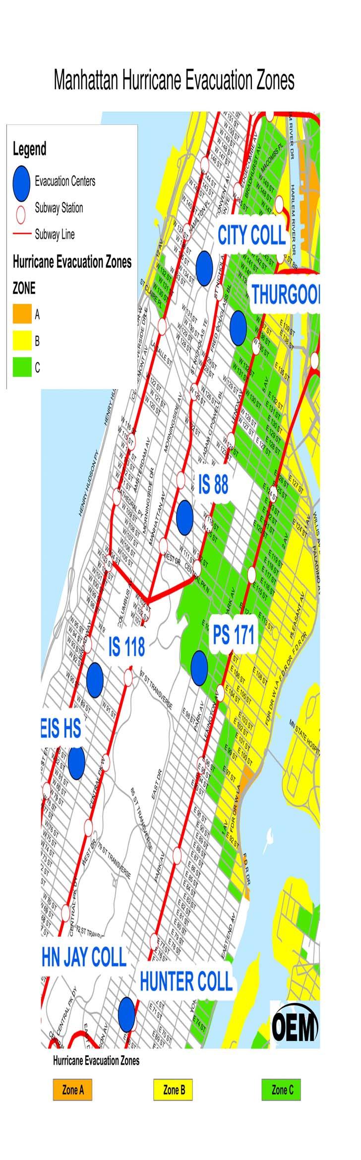
10 Post Katrina national focus on flood emergencies The NY Office of Emergency Preparedness released the New York City Coastal Storm Plan (CSP) to the public as Ready New York: Hurricanes and New York City Aug-Sept ( uide.shtml). The brochure + web, mailed to all residents living in designated hurricane evacuation zones in NYC. Large, fold-out map indicating areas designated hurricane evacuation zones, degree of hazard of zone, and where the evacuation centers are located.

11

12
13
14 Harlem Demographics 18% of East and Central Harlem residents are not proficient in English (NYC Dept Planning). Other languages - 82% speak Spanish (Healthy Harlem, 2006). Literacy Very Low - 46% of East Harlem residents and 33.5% of Central Harlem residents have not graduated high school. 38.2% live in poverty.
15 Harlem Environmental hazards, two sewage treatment plants, brownfields, six out of seven of Manhattan s diesel bus depots and home-based exposures percent children in central Harlem have asthma - double expected rate and one of highest ever documented for American neighborhood. 1996,Central Harlem had the highest crude death rate of 14.1 per 1,000 population compared to a citywide rate of 9.1 per 1,000. East Harlem tops the city in childhood asthma hospitalizations, with hospitalizations per 10,000 population for children aged 0-14 in the year 2000, compared to a citywide average of 64 per 10,000, and a national average of 33.6 childhood asthma hospitalizations per 10,000 people
16 Methods (Aug-Sept 2006) Street-readable sized version of the CSP Hurricane Evacuation Zone map. Cross-sectional - face-to-face interviews. Opportunistic/random sampling - various locations throughout East and Central Harlem Age 18 years or older. Total of 178 residents (134 English-speaking, 44 Spanish-speaking). Interviewers were trained ethnographers, supervised by a sociolinguist specializing in health literacy.
17 Questions Current knowledge, attitudes, and preparedness with emergency situations. 40% (n=72) had not graduated high school, a number very representative of the U.S. Census statistics that maintain 39% of East and Central Harlem adults have not graduated high school (New York City Department of City Planning, 2006).
18 Harlem Study Aug-Sept Surveyed 178 residents, aged 18+ (134 English-speaking, 44 Spanish-speaking). 83% of less-educated participants could not correctly identify which evacuation zone they lived in. High School or higher: 9.4 times more likely to be able to correctly identify their zone. 83% of less-educated said they did not know how to get to the evacuation center closest to their home. 46% of adults in E. Harlem have not completed High School. Thousands at risk.
19 Study Results 83% of less-educated participants (based on telling us where they lived) could not correctly identify which evacuation zone they lived in. (Those who had completed high school are 9.4 times more likely to be able to correctly identify their zone.) 83% of those with less education reported that they did not know how to get to the evacuation center closest to their home. HS or some/college - 48% said they did not know how to get to the closest evacuation center. Even before residents determined that the map was not clear and decipherable, 40% said they do not (somewhat/a little/not at all) trust emergency directions from city officials.
20 Findings Map is not readable and usable by a significant portion of the Harlem community. Vast majority of residents who had not completed HS could not correctly determine: if they lived in a hurricane evacuation zone which zone the correct location of the nearest Hurricane Evacuation Center 40% of those who had not graduated high school could not use the map to locate where they lived After adjusting for education, the other variables (age, sex, language, and length of time living in NYC) were not found to be significant.
21 Ability to Answer Questions Correctly while Looking at GIS Map (based on education level) Question Level of Education Incorrect n (%) Correct n (%) OR (CI)* Can you point to where you live? Low Ed 29 (40.3) 43 (59.7) 5.65 (2.58, 12.35) High Ed 11 (10.7) 92 (89.3) 1.0 Judging from these maps, do you live in a hurricane Low Ed 51 (73.9) 18 (26.1) 6.58 (3.32, 12.99) evacuation zone? High Ed 31 (30.1) 72 (69.9) 1.0 What zone do you live in? Low Ed 57 (82.6) 12 (17.4) 9.35 (4.44, 19.61) High Ed 34 (33.7) 67 (66.3) 1.0 Which hurricane evacuation center is closest to your Low Ed 46 (65.7) 24 (34.3) 5.32 (2.75, 10.31) home? High Ed 27 (26.5) 75 (73.5) 1.0 Do you know how to get there? Low Ed 57 (82.6) 12 (17.4) 5.15 (2.46, 10.75) High Ed 47 (48.0) 51 (52.0) 1.0 Low Ed = Less than High School; High Ed = At least High School graduate / GED *OR = Odds Ratio; CI = 95% Confidence Interval
22 Discussion
23 What makes GIS maps hard to read and use? Fundamental Literacy Vocabulary, phrases Numbers Science, civic and cultural literacies Visual topography The grammar of maps color, legends, physical orientation Connecting language and visuals
24 Elements of Complexity Color Typography Architecture/Layout Language Health and Environmental Literacy Load
25 What questions do you want your map to answer (functions) Is it reporting information (data) or is it asking people to analyze the data? Report/record What is it you re telling me? What is this before me? What do you want me to understand? What do you want me to do about/with it?

26
27 Titles of Maps make an art form of understatement Scientific Literacy highly deleted, compact, brief, nonnarrative language. Lead Exposure Risk Asthma Hospitalization Rates by Zip Code
28 Readers comprehend better when they can anticipate/frame Advance Organizer Get ready to read about Phrase + Advance Organizer
29 Clarify the declarative and propositional statements in a map When asthma is serious, children go to the hospital. This map shows where children are going to the hospital most because of asthma. This map uses zip codes to chunk communities. This map shows that many more children from Northern Manhattan are going to the hospital every year. This map shows where the polluters are bus depots, transfer stations, sewage treatment plants. Most of the polluters are in Northern Manhattan
30 Connecting the dots for readers: synthesizing More children in Northern Manhattan have asthma than anywhere else in NYC. Northern Manhattan has more than its fair share of polluters. Pollution is causing high rates of children s asthma in Northern Manhattan. What can be done?
31 Needed Research What is the linguistic and design structure of complexity in GIS information for vulnerable populations (low literate/low SES/ethnic minorities)? What does usability testing of GIS maps with low literate adults tell us about how GIS presentations can be adapted for greater readability and usability among the target audience? What are optimal templates for designing GIS maps to advance the use of these maps among low literate populations? What are best practice guidelines in writing, designing and using GIS map information with general and low literate publics?
32 Using GIS s potential and surmounting its flaws Good planning Appropriation of resources Careful goal setting by communicators/educators Incorporating Health Literacy principles Health/Environmental Literacy Incorporate Information Design principles

33 Indigenous knowledge use of local knowledge
34 Creating information that is matched to the health literacy needs of your population Identify the complexity/opportunity via an elaborated model of health literacy Collaborate with target audience collaborative GIS mapping Revise and simplify (appropriately) Contextualize Reinforce Evaluate and be ready to revise again
35 Conduct Health Literacy Load Analysis What does the material/message assume/require of the patient? Fundamental literacy Science literacy Civic literacy Cultural literacy
36 There is no civil ( and safe) society if we do not communicate and do so effectively. There is no capacity for social justice without communication.
MAKING PLANNING LOCAL
 Georgia Social Vulnerability Index 2010 Atlas MAKING PLANNING LOCAL VULNERABLE & AT-RISK POPULATIONS DATA FOR JURISDICTIONS AT THE CENSUS TRACT LEVEL Public Health Districts Regional Coordinating Hospital
Module 10 Summative Assessment
 Module 10 Summative Assessment Activity In this activity you will use the three dimensions of vulnerability that you learned about in this module exposure, sensitivity, and adaptive capacity to assess
Using GIS to Brief New York City Public Officials after September 11
 Using GIS to Brief New York City Public Officials after September 11 Presented by Zvia Segal Naphtali, Ph.D. and Leonard M. Naphtali, Ph.D. Presented at the ESRI International Health GIS Conference, May
Salem Coastal Vulnerability. By: Ariabel Adames, Abby Jackson, Mariluz Ayala, Mikara Crowley, Karley Skutul
 Salem Coastal Vulnerability By: Ariabel Adames, Abby Jackson, Mariluz Ayala, Mikara Crowley, Karley Skutul Total Population: 42,544 Sea level Rise: 10,700 Worst Case Storm Surge: 22,560 Minority Income
Measuring Disaster Risk for Urban areas in Asia-Pacific
 Measuring Disaster Risk for Urban areas in Asia-Pacific Acknowledgement: Trevor Clifford, Intl Consultant 1 SDG 11 Make cities and human settlements inclusive, safe, resilient and sustainable 11.1: By
Hennepin GIS. Tree Planting Priority Areas - Analysis Methodology. GIS Services April 2018 GOAL:
 Hennepin GIS GIS Services April 2018 Tree Planting Priority Areas - Analysis Methodology GOAL: To create a GIS data layer that will aid Hennepin County Environment & Energy staff in determining where to
4.2: Disaster Mitigation Strategies
 WMO/CAS/WWW SEVENTH INTERNATIONAL WORKSHOP ON TROPICAL CYCLONES 4.2: Disaster Mitigation Strategies Rapporteurs: Bill Read Regional Specialized Meteorological Center (RSMC) WMO Region IV 11691 SW 17 th
Spatial Disparities in the Distribution of Parks and Green Spaces in the United States
 March 11 th, 2012 Active Living Research Conference Spatial Disparities in the Distribution of Parks and Green Spaces in the United States Ming Wen, Ph.D., University of Utah Xingyou Zhang, Ph.D., CDC
Health and Medical Geography (GEOG 222)
") Spring 2019 Class meets: Tuesdays and Thursdays 12:30-1:45pm Carolina Hall Room 220 Instructor: Michael Emch Email: emch@unc.edu Course Objectives Health and Medical Geography (GEOG 222) This course is
Spring 2019 Class meets: Tuesdays and Thursdays 12:30-1:45pm Carolina Hall Room 220 Instructor: Michael Emch Email: emch@unc.edu Course Objectives Health and Medical Geography (GEOG 222) This course is
Standardized Symbologies for the Oregon Incident Response Information System (OR-IRIS)
") Standardized Symbologies for the Oregon Incident Response Information System (OR-IRIS) Chris Grant, Portland State University David Banis, Portland State University Don Pettit, Oregon Department of Environmental
Standardized Symbologies for the Oregon Incident Response Information System (OR-IRIS) Chris Grant, Portland State University David Banis, Portland State University Don Pettit, Oregon Department of Environmental
Geographic Systems and Analysis
 Geographic Systems and Analysis New York University Robert F. Wagner Graduate School of Public Service Instructor Stephanie Rosoff Contact: stephanie.rosoff@nyu.edu Office hours: Mondays by appointment
Environmental Analysis, Chapter 4 Consequences, and Mitigation
 Environmental Analysis, Chapter 4 4.17 Environmental Justice This section summarizes the potential impacts described in Chapter 3, Transportation Impacts and Mitigation, and other sections of Chapter 4,
Donna J. Kain, PhD and Catherine F. Smith, PhD East Carolina University
 Risk Perceptions and Emergency Communication Effectiveness in Coastal Zones Preliminary Findings on Interpretations of Weather Related Messages and Maps Donna J. Kain, PhD (kaind@ecu.edu), and Catherine
Many Ways to Name a Place
 Your web browser (Safari 7) is out of date. For more security, comfort and Activityapply the best experience on this site: Update your browser Ignore Many Ways to Name a Place What are the names for the
A HURRICANE IS COMING. Presented by Atiba Upchurch Broward Emergency Management Division
 A HURRICANE IS COMING Presented by Atiba Upchurch Broward Emergency Management Division Mission Statement To safeguard the lives and property of the people of Broward County from major hazards and emergencies
Hurricane Readiness for Coastal Communities
 Hurricane Readiness for Participant Guide Developed for: Federal Emergency Management Agency Emergency Management Institute 16825 South Seton Avenue Emmitsburg, MD 21727-8998 Developed by: C² Technologies,
Betty Hearn Morrow Consulting Sociologist Professor Emerita, Florida International University
 Betty Hearn Morrow Consulting Sociologist Professor Emerita, Florida International University 2018 WMO RA-IV Workshop on Hurricane Forecasting and Warning National Hurricane Center - Miami, Florida 8 March
Applying Health Outcome Data to Improve Health Equity
 Applying Health Outcome Data to Improve Health Equity Devon Williford, MPH, Health GIS Specialist Lorraine Dixon-Jones, Policy Analyst CDPHE Health Equity and Environmental Justice Collaborative Mile High
An online data and consulting resource of THE UNIVERSITY OF TOLEDO THE JACK FORD URBAN AFFAIRS CENTER
 An online data and consulting resource of THE JACK FORD URBAN AFFAIRS CENTER THE CENTER FOR GEOGRAPHIC INFORMATION SCIENCE AND APPLIED GEOGRAPHICS DEPARTMENT OF GEOGRAPHY AND PLANNING THE UNIVERSITY OF
John Laznik 273 Delaplane Ave Newark, DE (302)
") Office Address: John Laznik 273 Delaplane Ave Newark, DE 19711 (302) 831-0479 Center for Applied Demography and Survey Research College of Human Services, Education and Public Policy University of Delaware
Office Address: John Laznik 273 Delaplane Ave Newark, DE 19711 (302) 831-0479 Center for Applied Demography and Survey Research College of Human Services, Education and Public Policy University of Delaware
Use of Geospatial data for disaster managements
 Use of Geospatial data for disaster managements Source: http://alertsystemsgroup.com Instructor : Professor Dr. Yuji Murayama Teaching Assistant : Manjula Ranagalage What is GIS? A powerful set of tools
Medical GIS: New Uses of Mapping Technology in Public Health. Peter Hayward, PhD Department of Geography SUNY College at Oneonta
 Medical GIS: New Uses of Mapping Technology in Public Health Peter Hayward, PhD Department of Geography SUNY College at Oneonta Invited research seminar presentation at Bassett Healthcare. Cooperstown,
CRP 608 Winter 10 Class presentation February 04, Senior Research Associate Kirwan Institute for the Study of Race and Ethnicity
 CRP 608 Winter 10 Class presentation February 04, 2010 SAMIR GAMBHIR SAMIR GAMBHIR Senior Research Associate Kirwan Institute for the Study of Race and Ethnicity Background Kirwan Institute Our work Using
RETA 6422: Mainstreaming Environment for Poverty Reduction Category 2 Subproject
 RETA 6422: Mainstreaming Environment for Poverty Reduction Category 2 Subproject A. Basic Data 1. Subproject Title: Poverty-Environment Mapping to Support Decision Making 2. Country Director: Adrian Ruthenberg
WHAT HAPPENS WHEN A TORNADO STRIKES THE COMMUNITY? Carroll County Sheriff s Office Emergency Management
 WHAT HAPPENS WHEN A TORNADO STRIKES THE COMMUNITY? Carroll County Sheriff s Office Emergency Management WHAT IS EMERGENCY MANAGEMENT? Carroll County Sheriff s Office Emergency Management Agency is responsible
Red Hook Recovery Project. Hurricane Sandy An Urban Disaster
 Red Hook Recovery Project Hurricane Sandy An Urban Disaster Overview Impact of Changing weather Urban Preparedness Overview of preparedness efforts Complexities of urban planning (Ex. NYC) Understanding
METHODS FOR STATISTICS
 DYNAMIC CARTOGRAPHIC METHODS FOR VISUALIZATION OF HEALTH STATISTICS Radim Stampach M.Sc. Assoc. Prof. Milan Konecny Ph.D. Petr Kubicek Ph.D. Laboratory on Geoinformatics and Cartography, Department of
Oman NSDI Supporting Economic Development. Saud Al-Nofli Director of Spatial Data Directorate General of NSDI, NCSI
 Oman NSDI Supporting Economic Development 2017 Saud Al-Nofli Director of Spatial Data Directorate General of NSDI, NCSI "It s critical to make correct decisions the first time to optimize the Investments
Community Inclusion in Colorado
 A Mapping Project for Emergency Preparedness and Response Aimee Voth Siebert, MA Julia Beems, MA Rachel Coles, MA Devon Williford, MPH Adam Anderson, MURP, MPH March 2015 understanding that HUMAN ENERGY
User Guide. Affirmatively Furthering Fair Housing Data and Mapping Tool. U.S. Department of Housing and Urban Development
 User Guide Affirmatively Furthering Fair Housing Data and Mapping Tool U.S. Department of Housing and Urban Development December, 2015 1 Table of Contents 1. Getting Started... 5 1.1 Software Version...
Michael Thomas Sullivan
 Michael Thomas Sullivan michael.sullivan2@lc.cuny.edu Home Address 2319 Brigham Street Brooklyn, NY 11229 Cell (516) 729-8870 Academic Address Geographic Information Science Dept. Lehman College, CUNY
Your web browser (Safari 7) is out of date. For more security, comfort and. the best experience on this site: Update your browser Ignore
 is out of date. For more security, comfort and. the best experience on this site: Update your browser Ignore") Your web browser (Safari 7) is out of date. For more security, comfort and Activitydevelop the best experience on this site: Update your browser Ignore Places in the Park Why do we use symbols? Overview
Your web browser (Safari 7) is out of date. For more security, comfort and Activitydevelop the best experience on this site: Update your browser Ignore Places in the Park Why do we use symbols? Overview
Map-based Public Awareness Building System for Disaster Prevention
 90 Map-based Public Awareness Building System for Disaster Prevention Akira HATTORI, Sayaka MATSUMOTO, Takami YASUDA, and Shigeki YOKOI Kanagawa Institute of Technology, Japan Graduate School of Human
THE 3D SIMULATION INFORMATION SYSTEM FOR ASSESSING THE FLOODING LOST IN KEELUNG RIVER BASIN
 THE 3D SIMULATION INFORMATION SYSTEM FOR ASSESSING THE FLOODING LOST IN KEELUNG RIVER BASIN Kuo-Chung Wen *, Tsung-Hsing Huang ** * Associate Professor, Chinese Culture University, Taipei **Master, Chinese
Effective Use of Geographic Maps
 Effective Use of Geographic Maps Purpose This tool provides guidelines and tips on how to effectively use geographic maps to communicate research findings. Format This tool provides guidance on geographic
KENTUCKY HAZARD MITIGATION PLAN RISK ASSESSMENT
 KENTUCKY HAZARD MITIGATION PLAN RISK ASSESSMENT Presentation Outline Development of the 2013 State Hazard Mitigation Plan Risk Assessment Determining risk assessment scale Census Data Aggregation Levels
Social Vulnerability explorer (SV-X)
") 311 Social Vulnerability explorer (SV-X) D. P. Lanter 1 ; S. Durden 2 ; C. Baker 3 ; and C. M. Dunning 4 1 CDM Smith, Two Penn Center Plaza, 1500 JFK Blvd, Philadelphia, PA 19102. E-mail: lanterdp@cdmsmith.com
311 Social Vulnerability explorer (SV-X) D. P. Lanter 1 ; S. Durden 2 ; C. Baker 3 ; and C. M. Dunning 4 1 CDM Smith, Two Penn Center Plaza, 1500 JFK Blvd, Philadelphia, PA 19102. E-mail: lanterdp@cdmsmith.com
SYLLABUS. 1. Course description. Environmental Sciences. Physical, Chemical and Natural Systems Year: ECTS credits: 4.5.
 1. Course description Degree: Environmental Sciences Course: Natural Hazards Department: Physical, Chemical and Natural Systems Year: 2017-18 Term: Fall ECTS credits: 4.5 Course: 3 rd year Type: Basic
The Wind Hazard: Messaging the Wind Threat & Corresponding Potential Impacts
 The Wind Hazard: Messaging the Wind Threat & Corresponding Potential Impacts Scott Spratt Warning Coordination Meteorologist NWS Melbourne, FL David Sharp Science & Operations Officer NWS Melbourne, FL
Purpose Study conducted to determine the needs of the health care workforce related to GIS use, incorporation and training.
 GIS and Health Care: Educational Needs Assessment Cindy Gotz, MPH, CHES Janice Frates, Ph.D. Suzanne Wechsler, Ph.D. Departments of Health Care Administration & Geography California State University Long
Geospatial Technologies for Resources Planning & Management
 Geospatial Technologies for Resources Planning & Management Lal Samarakoon, PhD Director, Geoinformatics Center Asian Institute of Technology, Thailand Content Geoinformatics for SDG Information Integration
Acknowledgments xiii Preface xv. GIS Tutorial 1 Introducing GIS and health applications 1. What is GIS? 2
 Acknowledgments xiii Preface xv GIS Tutorial 1 Introducing GIS and health applications 1 What is GIS? 2 Spatial data 2 Digital map infrastructure 4 Unique capabilities of GIS 5 Installing ArcView and the
Jim Fox. copyright UNC Asheville's NEMAC
 Decisions and System Thinking Jim Fox November, 2012 1 UNC Asheville s s NEMAC National Environmental Modeling and Analysis Center Applied Research and technology development on integration of environmental
hurricane harvey and equitable recovery
 hurricane harvey and equitable recovery Mapping social vulnerability and intensity of wind and flooding from Hurricane Harvey in Texas hurricane harvey s impact on texas In August 2017, Hurricane Harvey
The Coastal Change Analysis Program and the Land Cover Atlas. Rebecca Love NOAA Office for Coastal Management
 The Coastal Change Analysis Program and the Land Cover Atlas Rebecca Love NOAA Office for Coastal Management Natural Infrastructure = Greater Resilience NOAA C-CAP Regional Land Cover and Change coast.noaa.gov/digitalcoast/data/ccapregional
Maps and sustainability
 Maps and sustainability The International Map Year [ mapyear.org ] Menno-Jan Kraak Maps Cartography and maps A map is a visual representation of an environment maps tell stories maps invite maps show patterns
HAZUS-MH: A Predictable Hurricane Risk Assessment Tool for the City of Houston and Harris County
 HAZUS-MH: A Predictable Hurricane Risk Assessment Tool for the City of Houston and Harris County Presented by Melvin G. Spinks, P.E., President Annie Ding, PhD, GISP October 29, 2008 Rice University Contents
By Daniel C. Edelson, PhD
 Your web browser (Safari 7) is out of date. For more security, comfort and the best experience on this site: Update your browser Ignore GEO - L ITERACY Preparation for Far-Reaching Decisions For the complete
INDIANA ACADEMIC STANDARDS FOR SOCIAL STUDIES, WORLD GEOGRAPHY. PAGE(S) WHERE TAUGHT (If submission is not a book, cite appropriate location(s))
 WHERE TAUGHT (If submission is not a book, cite appropriate location(s))") Prentice Hall: The Cultural Landscape, An Introduction to Human Geography 2002 Indiana Academic Standards for Social Studies, World Geography (Grades 9-12) STANDARD 1: THE WORLD IN SPATIAL TERMS Students
Prentice Hall: The Cultural Landscape, An Introduction to Human Geography 2002 Indiana Academic Standards for Social Studies, World Geography (Grades 9-12) STANDARD 1: THE WORLD IN SPATIAL TERMS Students
IMPLEMENTING GOVERNMENT-WIDE ENTERPRISE GIS; THE FEDERATED MODEL
 IMPLEMENTING GOVERNMENT-WIDE ENTERPRISE GIS; THE FEDERATED MODEL James E. Mitchell, Ph. D. IT GIS Manager Louisiana Department of Transportation and Development presented at the ESRI International Users
Flood Scenario Worksheet
 Flood Scenario Worksheet Scenario adapted from: http://www.epa.gov/watersecurity/tools/trainingcd/simple/source/scenario-8/ssc8-0.pdf Simple Tabletop Exercise, Interdependency Natural Disaster Scenario,
GIS in Weather and Society
 GIS in Weather and Society Olga Wilhelmi Institute for the Study of Society and Environment National Center for Atmospheric Research WAS*IS November 8, 2005 Boulder, Colorado Presentation Outline GIS basic
From Vulnerability to Resilience And the Tools to Get There. Out of Harm s Way Partnership for the Delaware Estuary August 1, 2012
 From Vulnerability to Resilience And the Tools to Get There Out of Harm s Way Partnership for the Delaware Estuary August 1, 2012 Today s Presentation Tour of New Jersey Challenges Definitions so we re
THINK RICE! GRADE 3 STANDARDS ALIGNMENT
 THINK RICE! GRADE STANDARDS ALIGNMENT National Social Studies Standards Standard I: Culture Eplore and describe similarities and differences in the ways groups, societies, and cultures address similar
A More Comprehensive Vulnerability Assessment: Flood Damage in Virginia Beach
 A More Comprehensive Vulnerability Assessment: Flood Damage in Virginia Beach By Raj Shah GIS in Water Resources Fall 2017 Introduction One of the most obvious effects of flooding events is death. Humans
Geodatabase for Sustainable Urban Development. Presented By Rhonda Maronn Maurice Johns Daniel Ashney Jack Anliker
 Geodatabase for Sustainable Urban Development Presented By Rhonda Maronn Maurice Johns Daniel Ashney Jack Anliker Objective Build a Geodatabase that will enable urban planners to create and assess the
Like other coastal cities, Honolulu s
 Worst-Case Scenarios: Flooding and Evacuation Plans in Honolulu Karl Kim, Pradip Pant, Eric Yamashita Like other coastal cities, Honolulu s long-term viability depends on how well it can adapt to climate
THE DATA REVOLUTION HAS BEGUN On the front lines with geospatial data and tools
 THE DATA REVOLUTION HAS BEGUN On the front lines with geospatial data and tools Slidedoc of presentation for MEASURE Evaluation End of Project Meeting Washington DC May 22, 2014 John Spencer Geospatial
News English.com Ready-to-Use English Lessons by Sean Banville
 www.breaking News English.com Ready-to-Use English Lessons by Sean Banville 1,000 IDEAS & ACTIVITIES FOR LANGUAGE TEACHERS www.breakingnewsenglish.com/book.html Thousands more free lessons from Sean's
Reducing Vulnerability to Extreme Heat: Science-Policy Interface
 Reducing Vulnerability to Extreme Heat: Science-Policy Interface Olga Wilhelmi, Mary Hayden, Jennifer Boehnert, Ursula Lauper and SIMMER research team October 23, 2013 Toronto SIMMER workshop Science-Policy
United States Multi-Hazard Early Warning System
 United States Multi-Hazard Early Warning System Saving Lives Through Partnership Lynn Maximuk National Weather Service Director, Central Region Kansas City, Missouri America s s Weather Enterprise: Protecting
Using Geospatial Methods with Other Health and Environmental Data to Identify Populations
 Using Geospatial Methods with Other Health and Environmental Data to Identify Populations Ellen K. Cromley, PhD Consultant, Health Geographer ellen.cromley@gmail.com Purpose and Outline To illustrate the
Shelter in Place Warning (SPW) A warning of an event where the public is recommended to immediately shelter in place (go inside, close doors and
 A warning of an event where the public is recommended to immediately shelter in place (go inside, close doors and") Shelter in Place Warning (SPW) A warning of an event where the public is recommended to immediately shelter in place (go inside, close doors and windows, turn off air conditioning or heating systems, and
Shelter in Place Warning (SPW) A warning of an event where the public is recommended to immediately shelter in place (go inside, close doors and windows, turn off air conditioning or heating systems, and
RSMC-Miami Update Daniel Brown Warning Coordination Meteorologist
 RSMC-Miami Update 2016 Daniel Brown Warning Coordination Meteorologist L-0324 Emergency Management Hurricane Preparedness Training Course Funding provided by FEMA s National Hurricane Program - partnership
Perception of Earthquake Risk and Postdisaster
 Perception of Earthquake Risk and Postdisaster Reconstruction: Comparative Study of Two Residential Neighborhoods on Different Socio-economic Status in Tehran Seyed Ali Badri University of Tehran, sabadri@ut.ac.ir
NEW YORK DEPARTMENT OF SANITATION. Spatial Analysis of Complaints
 NEW YORK DEPARTMENT OF SANITATION Spatial Analysis of Complaints Spatial Information Design Lab Columbia University Graduate School of Architecture, Planning and Preservation November 2007 Title New York
Citizen Science at the. U.S. Geological Survey
 Citizen Science at the U.S. Geological Survey David Applegate USGS Associate Director for Natural Hazards NRC Board on Earth Science & Resources December 5, 2014 U.S. Department of the Interior U.S. Geological
Typical information required from the data collection can be grouped into four categories, enumerated as below.
 Chapter 6 Data Collection 6.1 Overview The four-stage modeling, an important tool for forecasting future demand and performance of a transportation system, was developed for evaluating large-scale infrastructure
CERA-Atlantic Storm Surge Web Page: Improvements for 2013 Based on EM Feedback
 CERA-Atlantic Storm Surge Web Page: Improvements for 2013 Based on EM Feedback Jessica Losego Meteorologist University of North Carolina - Institute for the Environment Rick Luettich Director, UNC IMS
Data Collection. Lecture Notes in Transportation Systems Engineering. Prof. Tom V. Mathew. 1 Overview 1
 Data Collection Lecture Notes in Transportation Systems Engineering Prof. Tom V. Mathew Contents 1 Overview 1 2 Survey design 2 2.1 Information needed................................. 2 2.2 Study area.....................................
GEO Geohazards Community of Practice
 GEO Geohazards Community of Practice 1) Co-Chair of GHCP With input from: Stuart Marsh, GHCP Co-Chair Francesco Gaetani, GEO Secretariat and many GHCP contributors 1) Nevada Bureau of Mines and Geology
North Carolina Essential Standards Kindergarten Social Studies
 North Carolina s Kindergarten Social Studies Kindergarten through second grade students are introduced to an integrative approach of Social Studies by exploring aspects of self, others, families and communities
World Geography. WG.1.1 Explain Earth s grid system and be able to locate places using degrees of latitude and longitude.
 Standard 1: The World in Spatial Terms Students will use maps, globes, atlases, and grid-referenced technologies, such as remote sensing, Geographic Information Systems (GIS), and Global Positioning Systems
Climate Risk Visualization for Adaptation Planning and Emergency Response
 Climate Risk Visualization for Adaptation Planning and Emergency Response NCR Flood Fact Finding Workshop Ricardo Saavedra ricardo@vizonomy.com Social Media, Mobile, and Big Data St. Peter s Basilica,
Assessing Social Vulnerability to Biophysical Hazards. Dr. Jasmine Waddell
 Assessing Social Vulnerability to Biophysical Hazards Dr. Jasmine Waddell About the Project Built on a need to understand: The pre-disposition of the populations in the SE to adverse impacts from disaster
News English.com Ready-to-Use English Lessons by Sean Banville
 www.breaking News English.com Ready-to-Use English Lessons by Sean Banville 1,000 IDEAS & ACTIVITIES FOR LANGUAGE TEACHERS www.breakingnewsenglish.com/book.html Thousands more free lessons from Sean's
Social Vulnerability Index. Susan L. Cutter Department of Geography, University of South Carolina
 Social Vulnerability Index Susan L. Cutter Department of Geography, University of South Carolina scutter@sc.edu Great Lakes and St. Lawrence Cities Initiative Webinar December 3, 2014 Vulnerability The
Progress Report. Flood Hazard Mapping in Thailand
 Progress Report Flood Hazard Mapping in Thailand Prepared By: Mr. PAITOON NAKTAE Chief of Safety Standard sub-beuro Disaster Prevention beuro Department of Disaster Prevention and Mitigation THAILAND E-mail:
Tornado Preparedness. Monthly Safety Meeting
 Tornado Preparedness Monthly Safety Meeting Introduction Tornadoes can occur anywhere and at any time during the year. In an average year, 800 tornadoes are reported throughout the nation. The most violent
West Hollywood General Plan
 ITEM 2.RR. EXHIBIT B Providing a safe living environment is a fundamental goal and one of the most important challenges cities face today. Anticipating, planning for, and guarding against threats to public
Raising awareness about advantages of standardization of geographical names / Des avantages de la normalisation
 Madagascar, 2013 Raising awareness about advantages of standardization of geographical names / Des avantages de la normalisation Helen Kerfoot Past Chair, UNGEGN (2002-2012) (Natural Resources Canada)
The Tampa Bay Catastrophic Plan Presentation to CFGIS Users Group FDOT District 5 Urban Offices - Orlando July 30, 2010
 The Tampa Bay Catastrophic Plan Presentation to CFGIS Users Group FDOT District 5 Urban Offices - Orlando July 30, 2010 Brady Smith Senior Planner Tampa Bay Regional Planning Council Introduction Recent
RiskCity Training package on the Application of GIS for multi- hazard risk assessment in an urban environment.
 RiskCity Training package on the Application of GIS for multi- hazard risk assessment in an urban environment. Cees van Westen (Westen@itc.nl) & Nanette C. Kingma (Kingma@itc.nl) ITC: Training & Research
Strengthening Communities Through Neighborhood Data Baltimore Data Day 2015
 Strengthening Communities Through Neighborhood Data Baltimore Data Day 2015 #BaltimoreDataDay #VitalSigns13 @bniajfi www.bniajfi.org Role as Baltimore s Data Intermediary Democratization of Data Overcome
Developing a Community Geographical Information System (GIS) in Rural India
 in Rural India") Developing a Community Geographical Information System (GIS) in Rural India Before rushing off and describing the unique challenges of developing a small scale GIS system India I better first describe
Developing a Community Geographical Information System (GIS) in Rural India Before rushing off and describing the unique challenges of developing a small scale GIS system India I better first describe
Geographic Information Systems(GIS)
") Geographic Information Systems(GIS) Threat Analysis Techniques Overview What is GIS? Functional capabilities of GIS BCM Process and GIS How to leverage GIS in threat/risk analysis Ron Brown, CBCP Managing
Geographic Information Systems(GIS) Threat Analysis Techniques Overview What is GIS? Functional capabilities of GIS BCM Process and GIS How to leverage GIS in threat/risk analysis Ron Brown, CBCP Managing
Careful, Cyclones Can Blow You Away!
 Title: Careful, Cyclones Can Blow You Away! (Meteorology) Grade(s): 6-8 Introduction: Most people associate twisters with tornadoes, but in fact tropical twisters come from hurricanes. Hurricanes are what
Reading Area Community College (Pennsylvania) University of Pittsburgh at Johnstown TRANSFER COURSE NUMBER PITT JOHNSTOWN COURSE TITLE CREDITS COURSE
 University of Pittsburgh at Johnstown TRANSFER COURSE NUMBER PITT JOHNSTOWN COURSE TITLE CREDITS COURSE") TITLE PITT JOHNSTOWN TITLE ACC 105 Financial Accounting 3 ACCT 0115 Accounting Principles 1 3 ACC 110 Managerial Accounting 3 BUS 0000 Non-Equivalent* 3 ACC 120 Payroll Accounting 1 BUS 0000 Non-Equivalent*
TITLE PITT JOHNSTOWN TITLE ACC 105 Financial Accounting 3 ACCT 0115 Accounting Principles 1 3 ACC 110 Managerial Accounting 3 BUS 0000 Non-Equivalent* 3 ACC 120 Payroll Accounting 1 BUS 0000 Non-Equivalent*
Key Steps for Assessing Mission Critical Data for An ebook by Geo-Comm, Inc.
 Key Steps for Assessing Mission Critical Data for 9-1-1 An ebook by Geo-Comm, Inc. If you re reading this, you probably understand transitioning to Next Generation 9-1-1 (NG9-1-1) means your Geographic
Translating Ensemble Weather Forecasts into Probabilistic User-Relevant Information
 Translating Ensemble Weather Forecasts into Probabilistic User-Relevant Information Matthias Steiner with contributions from Robert Sharman, Thomas Hopson, Yubao Liu, Mike Chapman, and Mary Hayden Email:
UNESCO World Heritage Centre - Arab States Unit
 UNESCO World Heritage Centre - Arab States Unit Post-Conflict Reconstruction in the Middle East Context and in the Old City of Aleppo in Particular UNESCO Headquarter, 18-19 June 2015 ACTION PLAN resulting
Table G - 6. Mitigation Actions Identified for Implementation by the City of Kent ( ) (From Wilkin County Master Mitigation Action Chart)
 (From Wilkin County Master Mitigation Action Chart)") Table G - 6. Actions Identified by the () (From Master Action Chart) Multi-Hazard Plan, 2017 Action Comments 5 All-Hazards Local Planning & Regulations Update the Operations Plan on an annual basis. Work
Table G - 6. Actions Identified by the () (From Master Action Chart) Multi-Hazard Plan, 2017 Action Comments 5 All-Hazards Local Planning & Regulations Update the Operations Plan on an annual basis. Work
AFFH-T User Guide September 2017 AFFH-T User Guide U.S. Department of Housing and Urban Development
 AFFH-T User Guide Affirmatively Furthering Fair Housing Data and Mapping Tool v. 4.1 U.S. Department of Housing and Urban Development September 2017 Version 4.1 ❿ September 2017 Page 1 Document History
Barnabas Chipindu, Department of Physics, University of Zimbabwe
 DEFICIENCIES IN THE OPERATIONAL APPLICATIONS OF LONG - RANGE WEATHER PREDICTIONS FOR AGRICULTURE - RECOMMENDATIONS FOR IMPROVING THE TECHNOLOGY FOR THE BENEFIT OF AGRICULTURE AT THE NATIONAL AND REGIONAL
Your web browser (Safari 7) is out of date. For more security, comfort and. the best experience on this site: Update your browser Ignore
 is out of date. For more security, comfort and. the best experience on this site: Update your browser Ignore") Your web browser (Safari 7) is out of date. For more security, comfort and Activityengage the best experience on this site: Update your browser Ignore Comparing Historical Maps How can historical maps
Your web browser (Safari 7) is out of date. For more security, comfort and Activityengage the best experience on this site: Update your browser Ignore Comparing Historical Maps How can historical maps
Outline of Guideline for Development and Utilization of Tsunami Disaster Management Map
 Outline of Guideline for Development and Utilization of Tsunami Disaster Management Map Port and Airport Research Institute, Japan The Overseas Coastal Area Development Institute of Japan Ports and Harbours
Low-Income African American Women's Perceptions of Primary Care Physician Weight Loss Counseling: A Positive Deviance Study
 Thomas Jefferson University Jefferson Digital Commons Master of Public Health Thesis and Capstone Presentations Jefferson College of Population Health 6-25-2015 Low-Income African American Women's Perceptions
Dr. Emily A. Fogarty, Coordinator History, Politics and Geography Dept School of Arts & Sciences
 Geography Dr. Emily A. Fogarty, Coordinator History, Politics and Geography Dept. Emily.Fogarty@farmingdale.edu 631-420-2739 School of Arts & Sciences The History, Politics and Geography Department offers
Nurture Nature Center Receives Grant From National Oceanic and Atmospheric Administration To Study Flood Forecast and Warning Tools
 Nurture Nature Center Receives Grant From National Oceanic and Atmospheric Administration To Study Flood Forecast and Warning Tools One of four national awards by National Weather Service to advance weather
I CAN STATEMENTS 6TH GRADE SOCIAL STUDIES
 6TH GRADE SOCIAL STUDIES I can compare historical issues involving rights, roles and statues of individuals. I can describe the relationships among specialization, division of labor, productivity of workers