Using GIS Data and GPS Mapping to Expedite Area Recovery from Natural Disasters
|
|
|
- Mervyn Stone
- 5 years ago
- Views:
Transcription

1 Using GIS Data and GPS Mapping to Expedite Area Recovery from Natural Disasters
2 Who is this guy? Thomas B Toby Sanford GIS Manager for GTPDD 13 years Bachelors Degree from Mississippi State University Geology Masters Degree from Delta State University Geospatial Technologies
3 Who is this guy? I have overseen the mapping and readdressing of 6 Counties and 15 municipalities From the addressing projects, I have done; 1) School Bus Routing 2) Trash Truck Routing 3) Corrected Voter Rolls 4) Helped Tax Assessors 5) Corrected Web Map Data 6) Too many to name!!

4 Who is Golden Triangle? A nonprofit organization formed in June 1971 to improve and enlarge economic development and civic improvement in 7 counties within the state of Mississippi.

5 Mississippi Planning & Development Districts Planning & Development District CENTRAL MISSISSIPPI EAST CENTRAL MISSISSIPPI GOLDEN TRIANGLE NORTH CENTRAL MISSISSIPPI NORTH DELTA NORTHEAST MISSISSIPPI SOUTH DELTA SOUTH MISSISSIPPI SOUTHWEST MISSISSIPPI THREE RIVERS


6 Who is Golden Triangle? Counties include: Choctaw Clay Lowndes Noxubee Oktibbeha Webster Winston The goal of the organization is to assist local units of government and small businesses with highly specialized areas that fall outside of its range of expertise.


7 Who is Golden Triangle?
8 Services Offered A variety of services are offered via GTPDD to the counties we serve. These include: Support for Senior Citizens Human Services to Promote Independence for Individuals Pharmacy Support Planning Services for communities and small businesses


9 Planning Services Division Economic & Community Development IT Support Geographic Information Systems Utility Services Small Business Loans

10 Equipment Used SUB-METER HEMISPHERE GPS YUMA TRIMBLE Solo-field Mapping software


11 Equipment Used
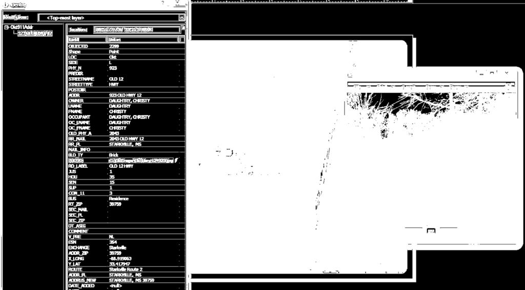
12 Geographic Information Systems Map all structures in our counties and cities to true coordinates

13 Coordinates LATITUDE & LONGITUDE LATITUDE LONGITUDE dd.ddddd dd dm.mmm dd mm ss.sss USNG UTM
14

15

16 WHAT WE DO 1. Go out and map a County and City to all structures true coordinates. 2. Create a good street network using the official county road register making sure all roads have the correct name and spelling. 3. Make sure that each road is in the correct location spatially and that it is properly center-lined.

17
18
19

20 Why Map?

21 Ensuring County (Or governing body) Receives Revenue Due Using the solid waste billing database and the physical addressing database, the county can locate all residents that are not being billed by the solid waste department In Webster County, MS the 911 addressing located 946 residences that were not receiving a solid waste bill. $113,520 was saved per year for the County Tax Payers
")
22 Direct Savings to School Districts By re-routing the City / County school busses we were able to save the school district, and City / County tax payers $85, per school year (Fuel Savings Alone = $3,092.27)


23

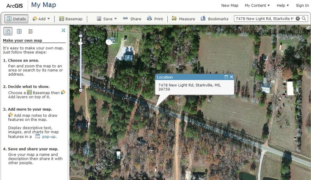
24 City/County Geo-Database Some layers are created from the field mapping, some exist and can be acquired from USGS, MARIS, etc. and all can be utilized to put all the pieces of the puzzle in place. What do these things do for a community? 1) Correct voter roll problems 2) Correct Address Errors 3) Routing of city services such as trash, school bus, fire truck, and police 4) Maintenance on roads and city services become easier to manage and know where the problems are

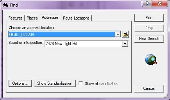
25 Use for 911 Emergencies We go a step further and re-define the county addresses using the 911 National Standard Address every 5.28 feet 5280 feet = one mile 1000 addresses per mile Address 1000 is one mile from the beginning of the road Faster response time for police, fire and EMS


26 Card Front Card Back

27

28

29
30

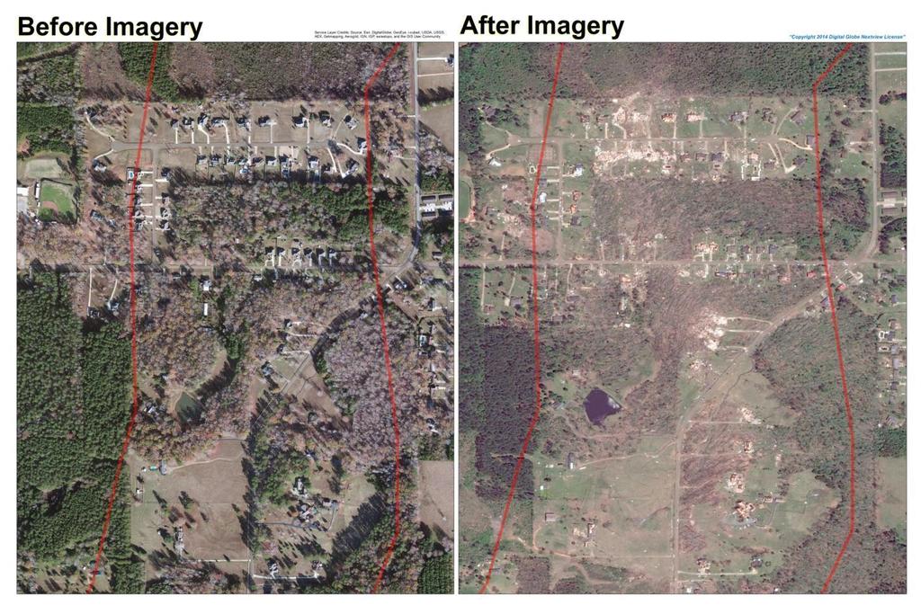
31 Recovery for Natural Disasters F4 Tornado hits Winston County, MS April 28, 2014

32 After the Storm
33

34 Emergency Recovery Process Begins Mississippi Governor Phil Bryant

35 Mayor - Will Hill EMA Director Buddy King MEMA Director Robert Latham


36 Senator Roger Wicker Congressman Greg Harper


37 Documentation of Damage Digital images with Geo-location data


38 Devastation

39 Before and After Documentation


40 Before and After Documentation


41 Results of Having GIS Information 646 Smart Images (photos with GPS data embedded) taken within 1.5 days Direct impact to Winston County budgets known within 24 hours Paperwork completed and filed with MEMA/FEMA within 48 hours Request for funds processed completely within 28 days Currently, this event is the fastest storm-recovery response in history within the State of Mississippi NOTE: One year later, other counties affected by storm are still trying To get necessary documentation needed for FEMA reimbursement

42 Financial Impact DAMAGE COUNT DESTROYED 295 MAJOR 81 MINOR 102 AFFECTED 168 TOTAL 646 CASUALTIES 10 LOSS CALCULATED FROM TAX ROLL* LOSS AT 20% ADDED TO TOTAL $32,212, $38,654,564.40
43 Advance Planning is Key 9/2011 2/ /2012 4/28/2014 5/5-7/2014 5/8/2014 Apply for grant money to support GIS mapping in county GTPDD began mapping Winston County GIS Mapping completed Tornado hits Winston County, MS Visit to area to document damage using MapSight Data & maps turned over to county and MEMA/FEMA If you need the GIS data and images, and you don t have it it s too late!
44 Questions?
45 Thank you! Toby Sanford GIS Manager GTPDD Phone tsanford@gtpdd.com
The Use of Geographic Information Systems (GIS) by Local Governments. Giving municipal decision-makers the power to make better decisions
 by Local Governments. Giving municipal decision-makers the power to make better decisions") The Use of Geographic Information Systems (GIS) by Local Governments Giving municipal decision-makers the power to make better decisions Case Study: Examples of GIS Usage by Local Governments in North
The Use of Geographic Information Systems (GIS) by Local Governments Giving municipal decision-makers the power to make better decisions Case Study: Examples of GIS Usage by Local Governments in North
GIS Monroe Geographic Information System March 14, 2018
 GIS Monroe Geographic Information System March 14, 2018 Goals Maintain Enterprise/County-wide geo-database Increase spatial accuracy of data Build and acquire more data layers Increase use of GIS; as another
2016 APWA Snow Conference. Web-based GIS for Municipal Snow Operations
 2016 APWA Snow Conference Web-based GIS for Municipal Snow Operations Christopher M. Cignoli, P.E. - Director of Public Works, Springfield, MA Bob Houldson - Director IT Services for the Department of
Geospatial natural disaster management
 Geospatial natural disaster management disasters happen. are you ready? Natural disasters can strike almost anywhere at any time, with no regard to a municipality s financial resources. These extraordinarily
GIS Needs Assessment. for. The City of East Lansing
 GIS Needs Assessment for The City of East Lansing Prepared by: Jessica Moy and Richard Groop Center for Remote Sensing and GIS, Michigan State University February 24, 2000 Executive Summary At the request
THE BEST POLICY (SMART) DECISIONS COME FROM SPATIALLY CONNECTED GOVERNMENT
 DECISIONS COME FROM SPATIALLY CONNECTED GOVERNMENT") THE BEST POLICY (SMART) DECISIONS COME FROM SPATIALLY CONNECTED GOVERNMENT Andy Wilson Ordnance Survey International andy.wilson@osi.os.uk Geospatial World Forum, Rotterdam, May 24th Mapping is everywhere
THE BEST POLICY (SMART) DECISIONS COME FROM SPATIALLY CONNECTED GOVERNMENT Andy Wilson Ordnance Survey International andy.wilson@osi.os.uk Geospatial World Forum, Rotterdam, May 24th Mapping is everywhere
CITY OF RIVERSIDE USING HAZUS TO CREATE A EARTHQUAKE PLANNING GUIDE FOR A UNIFIED FIELD RESPONSE
 CITY OF RIVERSIDE USING HAZUS TO CREATE A EARTHQUAKE PLANNING GUIDE FOR A UNIFIED FIELD RESPONSE Presented by the Phil McCormick City of Riverside Office of Emergency Management HISTORY The City had several
GIS. in the City of Lewiston Maine
 GIS in the City of Lewiston Maine The purpose of this slideshow is to provide an overview of the city GIS and how it is used, maintained and accessed in-house as well as by the public. Please simply hit
Appendix A. City of East Lansing Interview Report
 Department: City Clerk Meeting Participants: Sue Donnell, City Clerk Data Provider: The City Clerk s office maintains and updates all voting and election data. These data include legislative, school, and
Mary Sharp 1, CFM, GIS Manager. Nicholas Wissler 2, GIS Manager. James Stevenson 1, GISP, GIS Specialist. Matt Batina 1, GIS Specialist
 Mapping Infrastructure Damages from FEMA Field Notes in Support of the City of New Orleans Hurricane Katrina Disaster Recovery Efforts Mary Sharp 1, CFM, GIS Manager Nicholas Wissler 2, GIS Manager James
WELCOME & INTRODUCTIONS
 GIS Monroe Geographic Information System January 31, 2018 WELCOME & INTRODUCTIONS Chip Thomas, Ritter GIS Sarah Schrader, Acct. Mgr., ESRI Chris Beyett, Solutions Engineer, ESRI Colleen Hinzmann, IT Director,
Information. Information Technology. Geographic. Services (GIS) 119 W Indiana Ave Deland, FL 32720
 119 W Indiana Ave Deland, FL 32720") Information Technology Geographic Information Services (GIS) 119 W Indiana Ave Deland, FL 32720 A GIS consists of 5 primary components: Hardware Software People Data Methods or Business Processes --- Hardware
Information Technology Geographic Information Services (GIS) 119 W Indiana Ave Deland, FL 32720 A GIS consists of 5 primary components: Hardware Software People Data Methods or Business Processes --- Hardware
2018 NASCIO Award Submission Category: Cross-Boundary Collaboration and Partnerships. Project Title: Tennessee Wildfires: A Coordinated GIS Response
 2018 NASCIO Award Submission Category: Cross-Boundary Collaboration and Partnerships Project Title: Tennessee Wildfires: A Coordinated GIS Response Sevier County, Tennessee State of Tennessee, Emergency
APWA New England Chapter 2015 Winter Snow Stories. Winter Snow Stories
 APWA New England Chapter 2015 Winter Snow Stories APWA North American Snow Conference, Hartford, CT May 25, 2016 Winter Snow Stories 1 Winter Snow Stories Today s Team of Public Works Experts Tom Collins,
GIS Geographical Information Systems. GIS Management
 GIS Geographical Information Systems GIS Management Difficulties on establishing a GIS Funding GIS Determining Project Standards Data Gathering Map Development Recruiting GIS Professionals Educating Staff
Lesson: Don t Wait For the Storm
 Lesson: Don t Wait For the Storm Developing a GIS for Plaquemines Parish, Louisiana Presented by: Daniel Mellott, GISP Burk Kleinpeter, Inc. Where is Plaquemines Parish? 1998 GIS Feasibility Study User
A Standards Approach. Grid-Based Risk Modeling:
 Lightning Talk Presentation Grid-Based Risk Modeling: A Standards Approach Talbot Brooks, Director, Center for Interdisciplinary Geospatial Information Technologies, Delta State University Grid-Based Risk
Utilizing GIS Technology for Rockland County. Rockland County Planning Department Douglas Schuetz & Scott Lounsbury
 Utilizing GIS Technology for Rockland County Rockland County Planning Department Douglas Schuetz & Scott Lounsbury Presentation Agenda Introduction What is GIS What can GIS do GIS Efforts for BOE Resources
SNOW REMOVAL GUIDE. City Of Orange Township. Public Works Snow Removal Hotline: (973) My Orange Hotline: (973)
 My Orange Hotline: (973)") Mayor Dwayne D. Warren, Esq. And The Orange Municipal Council MOVING ORANGE FORWARD City Of Orange Township SNOW REMOVAL GUIDE Public Works Snow Removal Hotline: (973) 266-4030 My Orange Hotline: (973)
Mayor Dwayne D. Warren, Esq. And The Orange Municipal Council MOVING ORANGE FORWARD City Of Orange Township SNOW REMOVAL GUIDE Public Works Snow Removal Hotline: (973) 266-4030 My Orange Hotline: (973)
The Role of the Louisiana Geographic Information Center in the Response to Hurricane Katrina
 The Role of the Louisiana Geographic Information Center in the Response to Hurricane Katrina By: Jared Chapiewsky & Laura Brown For: URPL 969- GIS Applications in Response to Hurricane Katrina Date: March
A More Comprehensive Vulnerability Assessment: Flood Damage in Virginia Beach
 A More Comprehensive Vulnerability Assessment: Flood Damage in Virginia Beach By Raj Shah GIS in Water Resources Fall 2017 Introduction One of the most obvious effects of flooding events is death. Humans
Office of Geographic Information Systems
 Office of Geographic Information Systems Print this Page Spring 2009 - Desktop GIS: Dakota County GIS Extensions in ArcMap By Dan Castaneda In the past, the Office of GIS has created desktop extensions
COUNTY VOTED ONE CENT GAS TAX COUNTY TRANSPORTATION TRUST LIBRARY
 COMBINING STATEMENT OF,, AND C Page 1 of 7 COUNTY VOTED ONE CENT GAS TAX COUNTY TRANSPORTATION TRUST LIBRARY ) Taxes $ 2,300,000 2,315,042 15,042 7,280,000 7,327,461 47,461 8,250,846 8,341,344 90,498 Intergovernmental
Bringing GIS to the Front Lines Author- Mike Masters Co-Author James Kelt
 Pearland, Texas and Enterprise Wide GIS Bringing GIS to the Front Lines Author- Mike Masters Co-Author James Kelt Presenters Mike Masters- GIS Coordinator The City of Pearland, Texas Richard DeLa Mater-
What Are Disasters? The Rescue Kids Trio!
 The Rescue Kids Trio! What Are Disasters? This manual was made possible through funding by the Council of Local Authorities for International Relations. Disasters and emergency preparedness Emergency preparedness
Coconino County Common Snow Plow Questions/Concerns
 Coconino County Common Snow Plow Questions/Concerns I didn t know it snows so much in northern Arizona. Is this normal? According to the National Climatic Data Center, Flagstaff is the eighth snowiest
3Chapter Three: Rescue and Response
 17 16 Report Science Title and the Storms: the USGS Response to the Hurricanes of 2005 3Chapter Three: Rescue and Response This chapter documents the U.S. Geological Survey s (USGS) humanitarian rescue
INDIANAMAP VIEWING APPLICATION
 INDIANAMAP VIEWING APPLICATION (VERSION 1.0 ) Based on the 2005 Developed for the Indiana Department of Homeland Security by: IndianaMap Viewing Application Introduction The IndianaMap Viewing Application
Spatially Connected Government in Great Britain. Peter Hedlund CEO Ordnance Survey International
 Spatially Connected Government in Great Britain Peter Hedlund CEO Ordnance Survey International 1 Mapping is everywhere 2 Location - a vital component! 3 Location a meeting point for information? Postcode?
MODERNIZATION OF THE MUNICIPAL MAPPING USING HIGH END GNSS SYSTEM AND GIS SOFTWARE
 MODERNIZATION OF THE MUNICIPAL MAPPING USING HIGH END GNSS SYSTEM AND GIS SOFTWARE Mr. R. A. R. Khan Assistant Engineer, Sewerage Utility Management Centre (SUMC) Municipal Corporation Of Greater Mumbai
Hurricane Preparation and Recovery. October 11, 2011 Jon Nance, Chief Engineer, NCDOT
 Hurricane Preparation and Recovery October 11, 2011 Jon Nance, Chief Engineer, NCDOT North Carolina & Severe Weather Our state often bears the brunt of storms, which include: Ice storms Snow storms Heavy
The Tampa Bay Catastrophic Plan Presentation to CFGIS Users Group FDOT District 5 Urban Offices - Orlando July 30, 2010
 The Tampa Bay Catastrophic Plan Presentation to CFGIS Users Group FDOT District 5 Urban Offices - Orlando July 30, 2010 Brady Smith Senior Planner Tampa Bay Regional Planning Council Introduction Recent
FLOOD/SCS EVENT, APRIL 28 MAY 4
 REPORT DATE: May 4, 2017 EVENT DATE: April 28-May 4, 2017 FLOOD/SCS EVENT, APRIL 28 MAY 4 Event Summary General Significant Flood Outlook. SOURCE: National Weather Service. A significant severe thunderstorm
GIS for Planning and Revenue Collection
 GIS for Planning and Revenue Collection Laban Karanja & Barbara Seje GIS for County Government Seminar Agenda Introduction County goals County Challenges GIS as a solution for County challenges What Counties
Town of Barnstable. Department of Public Work. Snow and Ice Control Operations Plan
 Town of Barnstable Department of Public Work Snow and Ice Control Operations Plan I. Mission: The mission of the Department of Public Works is to remove accumulations of snow and ice from town, county
Your web browser (Safari 7) is out of date. For more security, comfort and the best experience on this site: Update your browser Ignore
 is out of date. For more security, comfort and the best experience on this site: Update your browser Ignore") Your web browser (Safari 7) is out of date. For more security, comfort and the best experience on this site: Update your browser Ignore GIS ( GEO GRAPHIC INFO RMATIO N SYSTEM) geospatial information system
Your web browser (Safari 7) is out of date. For more security, comfort and the best experience on this site: Update your browser Ignore GIS ( GEO GRAPHIC INFO RMATIO N SYSTEM) geospatial information system
CITY OF PORTLAND, TEXAS SERVICE PLAN FOR ANNEXATION AREA
 CITY OF PORTLAND, TEXAS SERVICE PLAN FOR ANNEXATION AREA Location and Acreage Approximately 1,863 acres of land in San Patricio County, located in the ETJ northwest of the existing City Limits. Metes and
Kentucky Collaborates in GeoMAPP Project: The Advantages and Challenges of Archiving in a State with a Centralized GIS
 Kentucky Collaborates in GeoMAPP Project: The Advantages and Challenges of Archiving in a State with a Centralized GIS Geospatial Multistate Archive and Preservation Partnership By Glen McAninch Best Practices
CITY OF NEW LONDON WINTER ROAD & SIDEWALK MAINTENANCE POLICY
 CITY OF NEW LONDON WINTER ROAD & SIDEWALK MAINTENANCE POLICY GENERAL The purpose of this policy is to set up acceptable procedures and policies for the winter maintenance of public areas in the City of
City of Saginaw Right of Way Division Snow and Ice Removal Policy January 18, 2016
 Snow and Ice Removal Policy January 18, 2016 It is the policy of the to provide snowplowing and ice removal services in order to: Provide safe traveling conditions for motorists and pedestrians Assist
GIS and Web Technologies to Improve Irrigation Districts
 GIS and Web Technologies to Improve Irrigation Districts Presented To: Montana Association of Dam and Canal Systems Workshop Presented By: Brian Fischer, CFM GIS Manager October 07, 2010 What you won t
Techniques for Science Teachers: Using GIS in Science Classrooms.
 Techniques for Science Teachers: Using GIS in Science Classrooms. After ESRI, 2008 GIS A Geographic Information System A collection of computer hardware, software, and geographic data used together for
Rural Louisiana. A quarterly publication of the Louisiana Tech Rural Development Center
 Rural Louisiana A quarterly publication of the Louisiana Tech Rural Development Center Volume 4, No. 1, Fall 2009 Editor: Aaron K. Lusby Director, Asst. Professor Newsletter design: Stephanie Tidwell Student
Measurement the Distance between Points on the Map
 International Journal of Engineering Science Invention ISSN (Online): 2319 6734, ISSN (Print): 2319 6726 ǁ Volume 3 ǁ Issue 1 ǁ January 2014 ǁ PP.01-06 Measurement the Distance between Points on the Map
Winter Ready DC District of Columbia Public Service Commission
 Winter Ready DC District of Columbia Public Service Commission Presented by: Michael Poncia, Vice President, Customer Operations, Pepco Holdings October 26, 2017 Preparing our System Improving our system
INDOT Office of Traffic Safety
 Intro to GIS Spatial Analysis INDOT Office of Traffic Safety Intro to GIS Spatial Analysis INDOT Office of Traffic Safety Kevin Knoke Section 130 Program Manager Highway Engineer II Registered Professional
MAPPS 2012 Geospatial Products and Services Excellence Awards Awards Entry Form
 MAPPS 2012 Geospatial Products and Services Excellence Awards 2012 Awards Entry Form Please include a copy of this document with the project/product submission Entry Information Submission Number: 1741558
Evaluating e-government : implementing GIS services in Municipality
 Evaluating e-government : implementing GIS services in Municipality Municipality of Thessaloniki - G.I.S. Unit Misirloglou Symeon Head of the GIS Unit ESRI UC - 2016 The GIS Section - subset of the department
Response Case Study: April 2014 Historic Flood Event. Severe Weather April 29 30, 2014
 Response Case Study: April 2014 Historic Flood Event NOAA s Regional Preparedness Training (NRPT) Natural Disaster Causing Technology Disasters in Mobile Bay Area Kimberly Albins Gulf of Mexico Regional
Exploit your geodata to enable smart cities and countries
 Exploit your geodata to enable smart cities and countries Carsten Rönsdorf, Head of Advisory Services Middle East Practice Manager Future Cities, standards and 3D 24 November 2014 Importance of Standards
Sharing GIS to Empower the End User David Wray, Roanoke County, Virginia
 Sharing GIS to Empower the End User David Wray, Roanoke County, Virginia Sharing GIS to Empower the End User Roanoke County, Virginia Roanoke County, Virginia Population: 92,901 Area: 251 Square Miles
BUILDING AN ASSET MANAGEMENT GEODATABASE FOR RANCHING. Matt Crawford, GISP
 BUILDING AN ASSET MANAGEMENT GEODATABASE FOR RANCHING Matt Crawford, GISP Introduction East Foundation Formed in 2007 Mission Research Education Outreach Properties Six ranches ~ 215,000 acres San Antonio
SMART GOVERNMENT= SPATIALY CONNECTED GOVERNMENT. Andy Wilson Ordnance Survey International
 SMART GOVERNMENT= SPATIALY CONNECTED GOVERNMENT Andy Wilson Ordnance Survey International andy.wilson@osi.os.uk Geosmart Asia, Kuala Lumpur, Oct 18 th, 2016 Mapping is everywhere Location- the vital component!
Understanding and Implementing the US National Grid
 Understanding and Implementing the US National Grid A training course designed to provide geospatial professionals the understanding and skills to support emergency responders and decision makers with
HURRICANE MATTHEW A GIS PERSPECTIVE GLYNN COUNTY GIS
 HURRICANE MATTHEW A GIS PERSPECTIVE GLYNN COUNTY GIS Situation September 25 th October 9 th 2016 Hurricane Matthew tracked its way up the east coast bringing hurricane force winds and flooding from Haiti
SITUATION REPORT: February 2018 Ohio River Flooding
 SITUATION REPORT: February 2018 Ohio River Flooding Hamilton County Emergency Management Situation Report: #28 Date of Issue: 03/06/2018 Time Issued: 1400 hrs. Prepared By: Irvin Jones Approved By: Ryan
A GIS TOUR OF DES MOINES PRESENTED BY ANNA WHIPPLE, GIS MANAGER APRIL 20, 2015
 A GIS TOUR OF DES MOINES PRESENTED BY ANNA WHIPPLE, GIS MANAGER APRIL 20, 2015 Welcome to Des Moines! Capital of Iowa Among 100 largest metropolitan areas Insurance, biotech, healthcare, and entertainment
BOWIE SENIORS COMPUTER CLUB
 BOWIE SENIORS COMPUTER CLUB Meeting Minutes for May 5, 2016 Through the efforts of Program Chairman Dan Lee, we had Patrick T. Callahan, GIS Manager of the Prince George's County Office of Information
Building a GIS with Limited Resources
 Building a GIS with Limited Resources VILLAGE OF LOMBARD Daniel Price, GIS Technician David Dratnol, Village Engineer About Lombard... 22 Miles from downtown Chicago 43,251 Residents (28th among 272 NIPC
geographic patterns and processes are captured and represented using computer technologies
 Proposed Certificate in Geographic Information Science Department of Geographical and Sustainability Sciences Submitted: November 9, 2016 Geographic information systems (GIS) capture the complex spatial
City of Lee s Summit Public Works Operations
 City of Lee s Summit Public Works Operations 2015 2016 Snow Operations August 3, 2015 GOAL The City of Lee s Summit s snow and ice goal is to provide a high level of customer service to our citizens within
Community and Infrastructure Services Committee
 REPORT TO: DATE OF MEETING: November 7, 2016 Community and Infrastructure Services Committee SUBMITTED BY: Cynthia Fletcher, Interim Executive Director INS 519-741- PREPARED BY: WARD(S) INVOLVED: 2600
E Geographic Information System. Created By: Freda Rocker Pearl River County Mapping
 E-9-1-1 Geographic Information System Created By: Freda Rocker Pearl River County Mapping frocker@pearlrivercounty.net Overview of Pearl River County E-9-1-1 Communications District GIS In 1998 the Pearl
Minnesota K-12 Academic Standards in Social Studies. Grade 4: Geography of North America
 Minnesota K-12 Academic s in Social Studies Grade 4: Geography of North America 4 Describe how people take 1. Democratic government action to influence a depends on informed and decision on a specific
GIS SERVICE CENTER MAP ORDER FORM
 Steven V. Stenger County Executive Pam Reitz Director of Administration GIS SERVICE CENTER MAP ORDER FORM 1. Print this form. 2. Fill out the form calculate and include the total cost of your order. 3.
John Laznik 273 Delaplane Ave Newark, DE (302)
") Office Address: John Laznik 273 Delaplane Ave Newark, DE 19711 (302) 831-0479 Center for Applied Demography and Survey Research College of Human Services, Education and Public Policy University of Delaware
Office Address: John Laznik 273 Delaplane Ave Newark, DE 19711 (302) 831-0479 Center for Applied Demography and Survey Research College of Human Services, Education and Public Policy University of Delaware
Enhancing Parcel Data In Colleton County. February 10, 2009
 Enhancing Parcel Data In Colleton County GIS & CAMA Conference February 10, 2009 Introductions Bruce T. Harper Technology Director Colleton County, SC Bill Wetzel National GIS Account Manager The Sidwell
WE, THE UNDERSIGNED qualified voters of the municipality of Sioux Falls, the state of South Dakota, petition that the following ordinance be
 Q30001.pptx WE, THE UNDERSIGNED qualified voters of the municipality of Sioux Falls, the state of South Dakota, petition that the following ordinance be submitted to the voters of that municipality for
A case study of Pavement Management in Chelan County
 INTEGRATING PAVEMENT MANAGEMENT AND GIS A case study of Pavement Management in Chelan County Our Road dto Full lladoption of a PMS The evolution of PMS at Chelan County Our current process Use of GIS to
BROOMFIELD COLORADO...
 2 0 1 6 P R O P O S E D A N N U A L B U D G E T C I T Y A N D C O U N T Y O F BROOMFIELD COLORADO............. 2 0 1 6 P R O P O S E D A N N U A L B U D G E T City and County of Broomfield, Colorado 2016
McHenry County Property Search Sources of Information
 Disclaimer: The information in this system may contain inaccuracies or typographical errors. The information in this system is a digital representation of information derived from original documents; as
Understanding China Census Data with GIS By Shuming Bao and Susan Haynie China Data Center, University of Michigan
 Understanding China Census Data with GIS By Shuming Bao and Susan Haynie China Data Center, University of Michigan The Census data for China provides comprehensive demographic and business information
Enterprise GIS: Realizing a Return on Investment. EGUG Coeur D Alene, ID Tuesday, October 15, 2002
 Enterprise GIS: Realizing a Return on Investment EGUG 2002 - Coeur D Alene, ID Tuesday, October 15, 2002 Technology Technology is great fun, but we can drown in our technology. The fog of information can
The Dance Hall Goes in What School District?
 The Dance Hall Goes in What School District? Vern C. Svatos Jarrod S. Doucette Abstract This paper presents the results of a GIS mapping effort created for the Delaware State Department of Education using
MUNICIPALITY OF ANCHORAGE PUBLIC TRANSPORTATION DEPARTMENT AnchorRIDES TRANSPORTATION SYSTEM
 Purpose: The Public Transportation Department and contracted provider will provide safe transportation for AnchorRIDES customers and employees during severe weather or emergency conditions. AnchorRIDES
Flood Hazard Zone Modeling for Regulation Development
 Flood Hazard Zone Modeling for Regulation Development By Greg Lang and Jared Erickson Pierce County GIS June 2003 Abstract The desire to blend current digital information with government permitting procedures,
STATE GEOGRAPHIC INFORMATION DATABASE
 STATE GEOGRAPHIC INFORMATION DATABASE Data Information and Knowledge Management STATE GEOGRAPHIC INFORMATION DATABASE EXECUTIVE SUMMARY Utah has developed one of the most comprehensive statewide GIS resources
If you aren t familiar with Geographical Information Systems (GIS), you. GIS, when combined with a database that stores response information,
, you. GIS, when combined with a database that stores response information,") Geographical Information Systems in EMS By William E. Ott If you aren t familiar with Geographical Information Systems (GIS), you should take a look at what GIS can offer you as an EMS manager. GIS, when
Geographical Information Systems in EMS By William E. Ott If you aren t familiar with Geographical Information Systems (GIS), you should take a look at what GIS can offer you as an EMS manager. GIS, when
BUDGET FOR YEAR ENDING SEPTEMBER 30, 2018
 Ordinary Income/Expense Income 40000 FRANCHISE FEES 40140 Other Franchise Fees 6,000.00 3,300.00 3,546.87 4,509.57 3,904.82 40100 Bowie Cass Electric 29,400.00 33,360.00 14,694.20 31,090.05 35,560.33 40110
GIS ADMINISTRATOR / WEB DEVELOPER EVANSVILLE-VANDERBURGH COUNTY AREA PLAN COMMISSION
 GIS ADMINISTRATOR / WEB DEVELOPER EVANSVILLE-VANDERBURGH COUNTY AREA PLAN COMMISSION SALARY RANGE INITIATION $43,277 SIX MONTHS $45,367 POSITION GRADE PAT VI The Evansville-Vanderburgh County Area Plan
Creating a Pavement Management System Using GIS
 Christopher Castruita PPD 631 Prof. Barry Waite & Prof. Bonnie Shrewsbury Creating a Pavement Management System Using GIS Problem Definition As is the case with many cities, the city of La Cañada Flintridge
THE SPATIAL DATA WAREHOUSE OF SEOUL
 THE SPATIAL DATA WAREHOUSE OF SEOUL Jae-Ho Han The Seoul Metropolitan Government Seoul City Hall, Taepyeongno 1(il)-ga, Jung-gu, Seoul 100-744, Korea djhjha@hanmail.net Impyeong Lee Dept. of Geoinformatics,
City of Milford GIS. Mark Goetz GIS Coordinator City of Milford MIS Department
 City of Milford GIS Mark Goetz GIS Coordinator City of Milford MIS Department Community Statistics Approximately 25 square miles 2000 Population 52,305 Number of Parcels 22,500 Condominiums 3,000 Commercial/Industrial
Status and Challenges on Geo-DRM Information Systems in Tonga
 Name: Mafua- i-vai utukakau Maka Status and Challenges on Geo-DRM Information Systems in Tonga 1 Roles and Relationships Land and Geographic Information Systems (LGIS) Unit: Establish updated high-resolution
The Importance of Geospatial in the Construction Industry. 10 December, 2015
 The Importance of Geospatial in the Construction Industry 10 December, 2015 Transformation will drive Build Operate Reduce Total Cost of Use Increased design freedom to deliver better infrastructure Reduce
Powerful Combination: GIS and Web Services
 IEEE DISTRIBUTED SYSTEMS ONLINE 1541-4922 2004 Published by the IEEE Computer Society Vol. 5, No. 2; February 2004 Powerful Combination: GIS and Web Services Adam Stone At the University of North Texas's
McHenry County Property Search Sources of Information
 Disclaimer: The information in this system may contain inaccuracies or typographical errors. The information in this system is a digital representation of information derived from original documents; as
SNOW CONTROL OPERATIONS 2017 PUBLIC SERVICES DEPARTMENT MAINTENANCE DIVISION
 SNOW CONTROL OPERATIONS 2017 PUBLIC SERVICES DEPARTMENT MAINTENANCE DIVISION 1 SNOW CONTROL OPERATIONS The following are the standard operating procedures f snow removal operations. 1. Plowing operations
WHAT HAPPENS WHEN A TORNADO STRIKES THE COMMUNITY? Carroll County Sheriff s Office Emergency Management
 WHAT HAPPENS WHEN A TORNADO STRIKES THE COMMUNITY? Carroll County Sheriff s Office Emergency Management WHAT IS EMERGENCY MANAGEMENT? Carroll County Sheriff s Office Emergency Management Agency is responsible
Engineer's Report. Main Street Business Area. Festoon Lighting and Sidewalk Cleaning Assessment District (Fiscal Year )
") Engineer's Report for the Main Street Business Area Festoon Lighting and Sidewalk Cleaning Assessment District (Fiscal Year 2008-09) Prepared under the provisions of the Benefit Assessment Act of 1982
Engineer's Report for the Main Street Business Area Festoon Lighting and Sidewalk Cleaning Assessment District (Fiscal Year 2008-09) Prepared under the provisions of the Benefit Assessment Act of 1982
RESOLUTION NO INTRODUCTION
 RESOLUTION NO. 0824 A RESOLUTION TO ESTABLISH THIS CITY S SNOW AND ICE CONTROL POLICY DURING WINTER MONTHS, SPECIFICALLY DEFINED AS NOVEMBER THROUGH MARCH. BE IT RESOLVED BY THE CITY COUNCIL OF SOLON,
Reserve Forecast Details
 10-26th St South of Maryland Reserve (1552) Opening Balance 158,947 158,947 0 0 0 0 0 0 0 0 1058 - Street Construction 0 (158,947) 0 0 0 0 0 0 0 0 Total 0 (158,947) 0 0 0 0 0 0 0 0 Closing Balance 158,947
A HURRICANE IS COMING. Presented by Atiba Upchurch Broward Emergency Management Division
 A HURRICANE IS COMING Presented by Atiba Upchurch Broward Emergency Management Division Mission Statement To safeguard the lives and property of the people of Broward County from major hazards and emergencies
Cartographic Division Proposal
 Cartographic Division Proposal Steve Henderson, Public Works Engineer Background The City of Gulf Shores is expected to purchase or lease additional buildings across the street from City Hall to accommodate
KING GEORGE COUNTY DEPARTMENT OF COMMUNITY DEVELOPMENT
 GIS REPORT 2016 KING GEORGE COUNTY DEPARTMENT OF COMMUNITY DEVELOPMENT Background The GIS (Geographic Information System) coordinator was hired in 2001 to develop a GIS for King George County. Prior to
Sea Level Rise and Hurricane Florence storm surge research methodology
 Sea Level Rise and Hurricane Florence storm surge research methodology Hurricane Florence storm surge analysis was conducted using a variety of input sources. In order to determine the maximum storm surge
IH 35 at Blanco River May 2015
 IH 35 at Blanco River May 2015 Presentation Objectives Background of historical damage assessment processes Introduction to Collector App ( Mat Peck) Collector App and Flood Damage Assessment (Katie Steele)
To: Ross Martin, Lisa Stapleton From: Brad Lind Subject: Joint Funding Agreement with USGS for 2012 Imagery Date: March 14, 2012.
 To: Ross Martin, Lisa Stapleton From: Brad Lind Subject: Joint Funding Agreement with USGS for 2012 Imagery Date: March 14, 2012 Attached are two copies of the Joint Funding Agreement (JFA) between SanGIS
COUNCIL POLICY BACKGROUND
 COUNCIL POLICY Policy Title: Snow and Ice Control Policy Policy Number: TP004 Report Number: TTP2003-39, C2007-44, LPT2011-57 Approved by: City Council Effective Date: Interim policy approved 2009 December
I Background. Under the Cotton Tree: Situs Addressing System in Africa. Table of contents
 Cairo, April 2005 Under the Cotton Tree: Situs Addressing System in Africa Table of contents 1. Background 2. Current situation of addressing system in Africa 3. Benefits of a functional addressing system