Mary Sharp 1, CFM, GIS Manager. Nicholas Wissler 2, GIS Manager. James Stevenson 1, GISP, GIS Specialist. Matt Batina 1, GIS Specialist
|
|
|
- Edward Kennedy
- 5 years ago
- Views:
Transcription


1 Mapping Infrastructure Damages from FEMA Field Notes in Support of the City of New Orleans Hurricane Katrina Disaster Recovery Efforts Mary Sharp 1, CFM, GIS Manager Nicholas Wissler 2, GIS Manager James Stevenson 1, GISP, GIS Specialist Matt Batina 1, GIS Specialist 1 Jacobs/CSRS New Orleans Grants Management Group 2 The Department of Public Works, City of New Orleans Background Photo Credit: NOAA,

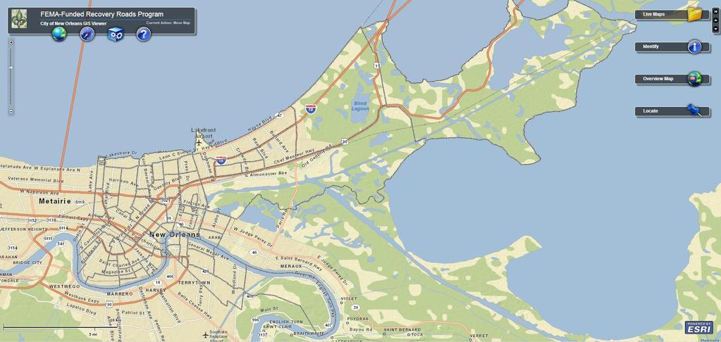
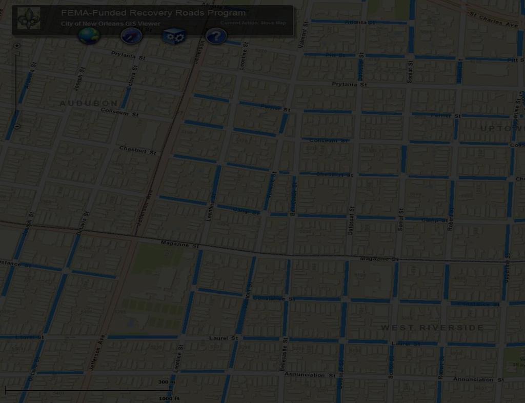
2 Project Background Federal Emergency Management Agency- Funded Recovery Roads Program City of New Orleans Department of Public Works Significant effort to get to this point

3 Purpose Stafford Act and Public Assistance Program Katrina damage to infrastructure, private property Identification of storm damages Translate FEMA eligibility written in the field into something useful for repair design Demonstrate to the public where the work is going to be performed
4
5

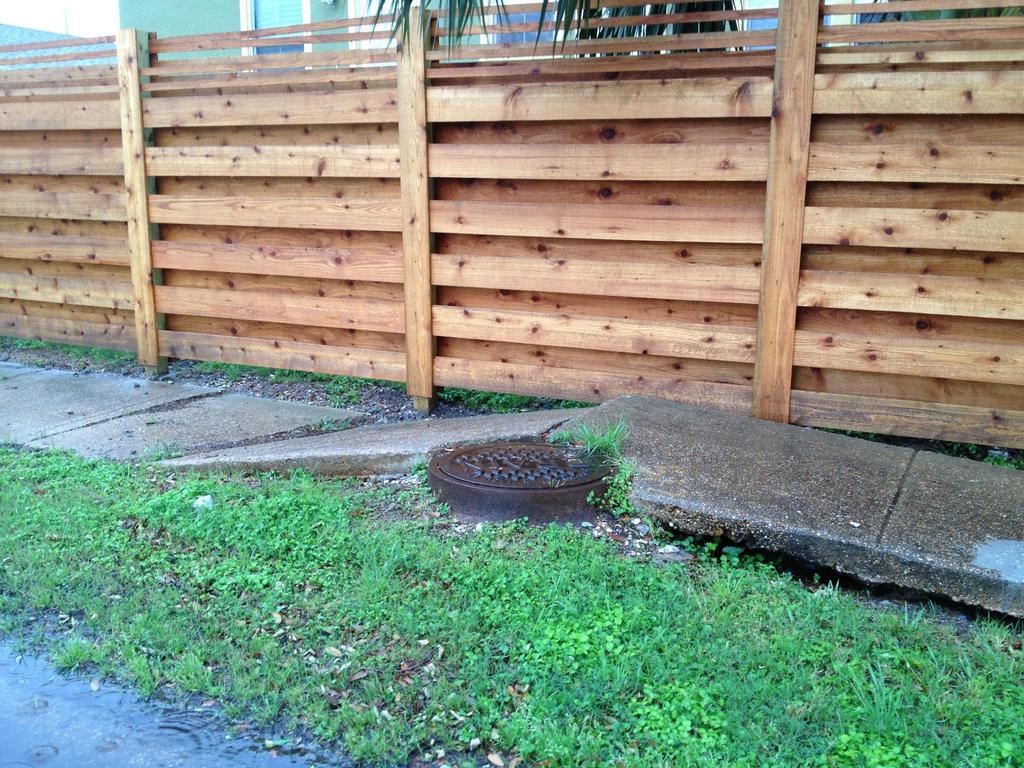
6 Insert Damage Photo

7

8 Project Scope Develop GIS data of field-identified damages Provide support to The Department of Public Works for coordination of repairs to obligated damages Multiple entities involved At least 50 A/Es estimated to perform repair work Continuing project support to The Department of Public Works and refinement of the GIS data

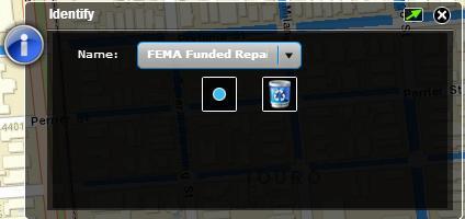
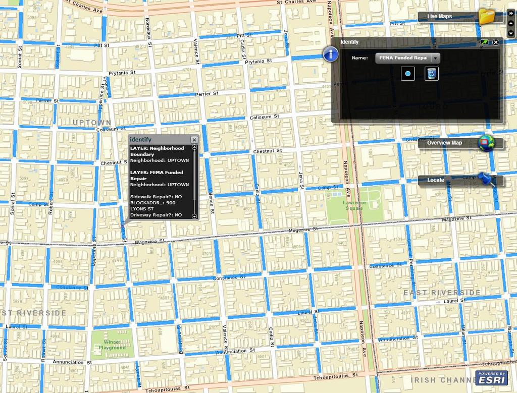
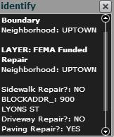
9 Benefits of the Geospatial Approach Supply visual aids for public outreach Visualization of FEMA project worksheet damages Provide planning-level project worksheet repair location data to designers Provide digital archive of project worksheet repair locations
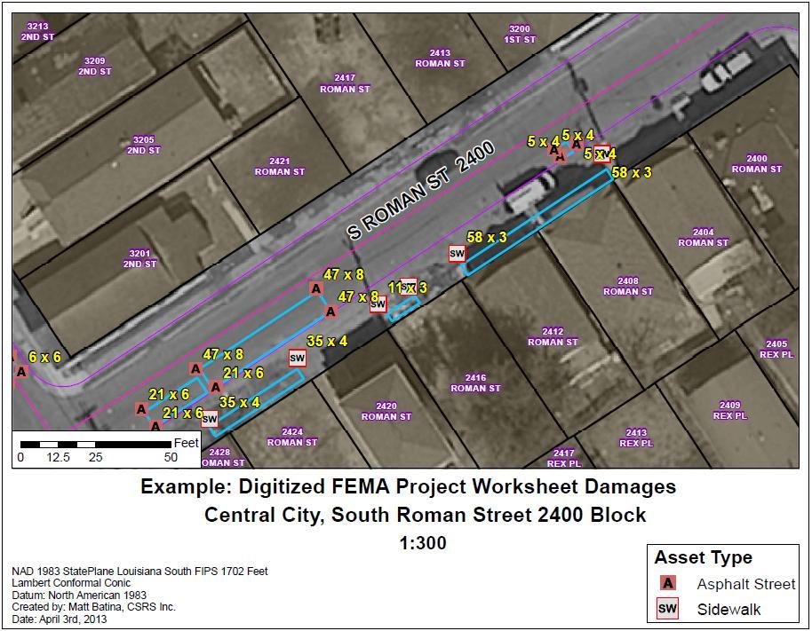
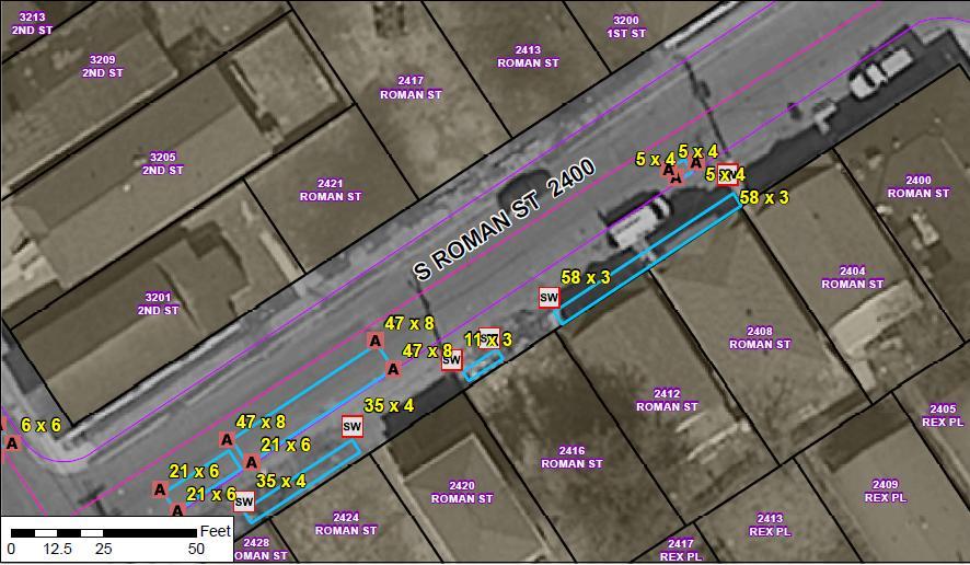
10 Example FEMA Project Worksheet Field Notes

11 What We Used - Example PW Spreadsheet

12 Evolution of GIS PW Data Examples of PW Field Inspection Data

13 Evolution of GIS PW Data Raw GPS Points Collected by Jacobs/CSRS Field Teams

14 Evolution of GIS PW Data GIS PW Datasets Derived from Raw GPS Point Data
15
16

17 How Much Data There Really Was to Collect


18 Program Data Development Tasks and Timeline Phase II Assessments Data Entry from Assessments Field GPS Data Capture Develop/Refine GIS Data fromgps Data Website Dev. GIS/Mapping Support and Data Development

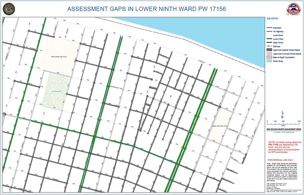
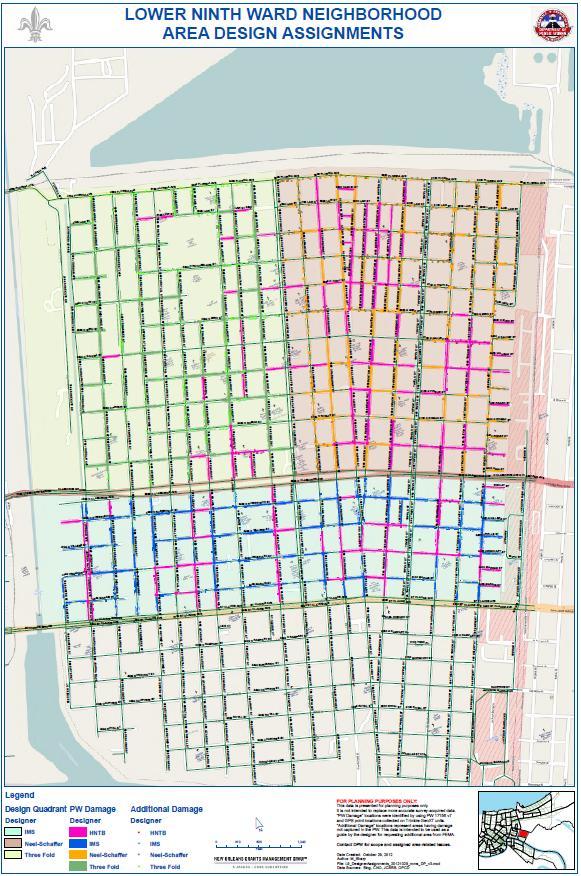
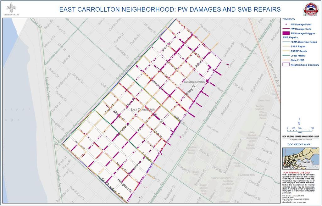
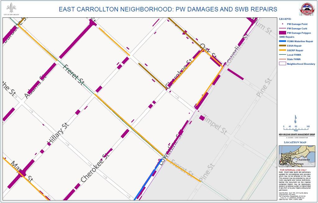
19 Coordination Efforts Keep the public informed of where work is projected to take place The Department of Public Works and Sewerage and Water Board have differing responsibilities Coordination with designers for staging and assignment of work Coordination of street repairs with Sewerage and Water Board repairs Use of GIS data to refine projections of areas where full or partial block repairs will occur
20

21
22

23 5900 N ROMAN ST 1600 BENTON ST 1700 BENTON ST 5700 N CLAIBORNE AVE 1600 LAMANCHE ST N CLAIBORNE AVE 1400 LAMANCHE ST 1500 GORDON ST 1700 GORDON ST 1400 GORDON ST 1600 GORDON ST 1700 CHARBONNET ST 1400 CHARBONNET ST 1400 STRAND CT 1700 ALABO ST1400 ALABO ST 1600 ALABO ST 1500 ALABO ST Legend PW Damage Designer HNTB IMS Neel-Schaffer
24
25
26 Benefits to the Client Everyone loves maps! Frequent use by The Department of Public Works Coordination Project Managers Public Relations Department Benefits
27 Benefits to the Client Accountability for Mayor and Director of Public Works Planning


28 Challenges Faced and Lessons Learned Field conditions and equipment issues Need to hire and train field crews Several on-the-fly adjustments to data collection Tight timeline 145 days to complete collection
29 Overall Project Benefits Effective project coordination Maximized utilization of funding toward repairs Saving taxpayer dollars Long-term benefits
30 Acknowledgements City of New Orleans, The Department of Public Works Sewerage and Water Board of New Orleans Orleans Parish Communication District Federal Emergency Management Agency Louisiana Governor s Office of Homeland Security and Emergency Preparedness Design Firms Jacobs/CSRS New Orleans Grants Management Group
31 Recovery Roads Website Please visit us! Interactive GIS Map of PW Damages

32
33
34
35
36

37 Q & A Questions
3Chapter Three: Rescue and Response
 17 16 Report Science Title and the Storms: the USGS Response to the Hurricanes of 2005 3Chapter Three: Rescue and Response This chapter documents the U.S. Geological Survey s (USGS) humanitarian rescue
Jefferson Parish GIS Hurricane Response Review. From the information given by A.J. Tapie, GIS Manager of Jefferson Parish, the use of
 Neil Dixon and Ryan Ziegelbauer URPL 969 3/10/2006 Jefferson Parish GIS Hurricane Response Review From the information given by A.J. Tapie, GIS Manager of Jefferson Parish, the use of GIS in the Parish
WHAT HAPPENS WHEN A TORNADO STRIKES THE COMMUNITY? Carroll County Sheriff s Office Emergency Management
 WHAT HAPPENS WHEN A TORNADO STRIKES THE COMMUNITY? Carroll County Sheriff s Office Emergency Management WHAT IS EMERGENCY MANAGEMENT? Carroll County Sheriff s Office Emergency Management Agency is responsible
The Role of the Louisiana Geographic Information Center in the Response to Hurricane Katrina
 The Role of the Louisiana Geographic Information Center in the Response to Hurricane Katrina By: Jared Chapiewsky & Laura Brown For: URPL 969- GIS Applications in Response to Hurricane Katrina Date: March
Enhancing Louisiana s GNIS
 Enhancing Louisiana s GNIS An Outreach Effort Between USGS and the Louisiana Geographic Information Center Louisiana Remote Sensing and GIS Workshop Lafayette, LA April 28, 2010 Louisiana Geographic Information
Lesson: Don t Wait For the Storm
 Lesson: Don t Wait For the Storm Developing a GIS for Plaquemines Parish, Louisiana Presented by: Daniel Mellott, GISP Burk Kleinpeter, Inc. Where is Plaquemines Parish? 1998 GIS Feasibility Study User
Measuring and GIS Referencing of Network Level Pavement Deterioration in Post-Katrina Louisiana March 19, 2008
 Infrastructure Data Collection Solutions Measuring and GIS Referencing of Network Level Pavement Deterioration in Post-Katrina Louisiana March 19, 2008 Hurricane Katrina August 2005 I-10 I-610 West End
IH 35 at Blanco River May 2015
 IH 35 at Blanco River May 2015 Presentation Objectives Background of historical damage assessment processes Introduction to Collector App ( Mat Peck) Collector App and Flood Damage Assessment (Katie Steele)
Response Case Study: April 2014 Historic Flood Event. Severe Weather April 29 30, 2014
 Response Case Study: April 2014 Historic Flood Event NOAA s Regional Preparedness Training (NRPT) Natural Disaster Causing Technology Disasters in Mobile Bay Area Kimberly Albins Gulf of Mexico Regional
Report on the Damage Survey Caused by Hurricane Katrina (Tentative Report)
") Report on the Damage Survey Caused by Hurricane Katrina (Tentative Report) November 1, 2005 Coastal Disaster Prevention Technology Survey Team 1. Introduction Hurricane Katrina struck the United States
Report on the Damage Survey Caused by Hurricane Katrina (Tentative Report) November 1, 2005 Coastal Disaster Prevention Technology Survey Team 1. Introduction Hurricane Katrina struck the United States
IMPLEMENTING GOVERNMENT-WIDE ENTERPRISE GIS; THE FEDERATED MODEL
 IMPLEMENTING GOVERNMENT-WIDE ENTERPRISE GIS; THE FEDERATED MODEL James E. Mitchell, Ph. D. IT GIS Manager Louisiana Department of Transportation and Development presented at the ESRI International Users
Nebraska. Large Area Mapping Initiative. The Nebraska. Introduction. Nebraska Department of Natural Resources
 Nebraska Department of Natural Resources Introduction The Nebraska The Nebraska Department of Natural Resources (NDNR) has developed a process for using a geographic information system (GIS) to map Approximate
Using GIS Data and GPS Mapping to Expedite Area Recovery from Natural Disasters
 Using GIS Data and GPS Mapping to Expedite Area Recovery from Natural Disasters Who is this guy? Thomas B Toby Sanford GIS Manager for GTPDD 13 years Bachelors Degree from Mississippi State University
INTRODUCTION. The Beacon of Hope/University of New Orleans Community Recovery Project
 The Beacon of Hope/University of New Orleans Community Recovery Project INTRODUCTION In the direct aftermath of Hurricanes Katrina and Rita, the Beacon of Hope Resource Center (BOH), a non-profit focused
Statewide Topographic Mapping Program
 Statewide Topographic Mapping Program February 28, 2018 www.dotd.la.gov Outline Purpose of the Statewide Topographic Mapping Program History Breakdown of R.S. 48:36 - Topographic Mapping Statewide Topographic
E Geographic Information System. Created By: Freda Rocker Pearl River County Mapping
 E-9-1-1 Geographic Information System Created By: Freda Rocker Pearl River County Mapping frocker@pearlrivercounty.net Overview of Pearl River County E-9-1-1 Communications District GIS In 1998 the Pearl
United States Multi-Hazard Early Warning System
 United States Multi-Hazard Early Warning System Saving Lives Through Partnership Lynn Maximuk National Weather Service Director, Central Region Kansas City, Missouri America s s Weather Enterprise: Protecting
Continental Divide National Scenic Trail GIS Program
 CDNST Vision Statement: Provide the most accurate geospatial locational information of the Continental Divide Trail and nearby resources to the public as well as help provide internal management information
Kenneth Melchert (Senior Statistician - Regional Liaison Officer)
") Sourcing Spatial Data from Local Government Getting the Data Right The Supplier s Perspective Presenter: Kenneth Melchert (Senior Statistician - Regional Liaison Officer) Information Products and Services
Sourcing Spatial Data from Local Government Getting the Data Right The Supplier s Perspective Presenter: Kenneth Melchert (Senior Statistician - Regional Liaison Officer) Information Products and Services
The Indiana Data Sharing Initiative and the IndianaMap. Cross-Boundary Collaboration and Partnerships. State of Indiana
 The Indiana Data Sharing Initiative and the IndianaMap Cross-Boundary Collaboration and Partnerships State of Indiana Brian Arrowood, CIO James Sparks, GIO EXECUTIVE SUMMARY Under the collaboration oriented
Marine Debris in the Gulf of Mexico
 Marine Debris in the Gulf of Mexico Peter Murphy NOAA Marine Debris Program / Genwest Biloxi, Mississippi October 25, 2009 Outline 1. Project Background 2. Process 3. 2006-2007 Alabama, Mississippi 4.
Who has the data? Results of Maryland s 3-Week Statewide GIS Inventory Challenge. This is your state. This is your inventory.
 Who has the data? Results of Maryland s 3-Week Statewide GIS Inventory Challenge This is your state. This is your inventory. Maryland s Need for GIS Inventory Maryland had no central repository for its
Geospatial natural disaster management
 Geospatial natural disaster management disasters happen. are you ready? Natural disasters can strike almost anywhere at any time, with no regard to a municipality s financial resources. These extraordinarily
City of Punta Gorda Community Emergency Management Plan 2013
 City of Punta Gorda Community Emergency Management Plan 2013 Hurricane Andrew- August 24, 1992 Category 5 hurricane. The second-most-destructive hurricane in U.S. history. The first named storm of the
NOAA S2S Planning. Dave DeWitt Fred Toepfer
 NOAA S2S Planning Dave DeWitt Fred Toepfer 1 Agenda 1. Brief synopsis of The Weather Research and Forecasting Act of 2017 2. Report to Congress a. Timeline b. Process c. Document Outline 3. Some Preliminary
A New National Flood Inundation Mapping Science Initiative
 A New National Flood Inundation Mapping Science Initiative William Guertal, PhD. Director, USGS Indiana and Kentucky Water Science Centers U.S. Department of the Interior U.S. Geological Survey Courtesy
NC Emergency Management A View from the Counties
 NC Emergency Management A View from the Counties Amy Bason, NCACC Rocky Hyder, Henderson County Jeff Batten, Durham County Norman Bryson, Onslow County PARTNERSHIP Emergency Management efforts require
State-of-the-Art GIS as an Integrating Technology
 Paper # 104: GIS for Oil Spill Prevention & Response Devon Humphrey Instructor, National Spill Control School Texas A&M University at Corpus Christi, TX Introduction and History The National Spill Control
Hurricane Preparation and Recovery. October 11, 2011 Jon Nance, Chief Engineer, NCDOT
 Hurricane Preparation and Recovery October 11, 2011 Jon Nance, Chief Engineer, NCDOT North Carolina & Severe Weather Our state often bears the brunt of storms, which include: Ice storms Snow storms Heavy
Department of Industrial and Manufacturing Systems Engineering. The Online Hurricane Decision Simulator
 Department of The Online Hurricane Decision Simulator Cameron MacKenzie Assistant Professor Iowa State University Eva Regnier Associate Professor Naval Postgraduate 1 U.S. Marine Forces Reserve (MFR) Lt.
PUBLIC SAFETY POWER SHUTOFF POLICIES AND PROCEDURES
 PACIFIC GAS AND ELECTRIC COMPANY PUBLIC SAFETY POWER SHUTOFF POLICIES AND PROCEDURES SEPTEMBER 2018 1 PACIFIC GAS AND ELECTRIC COMPANY PUBLIC SAFETY POWER SHUTOFF POLICIES AND PROCEDURES SEPTEMBER 2018
Hurricanes Katrina and Rita created the largest natural disaster in American history
 Overview of the Road Home Program Hurricanes Katrina and Rita created the largest natural disaster in American history In Louisiana: 123,000 homes suffered major damage 82,000 rental properties suffered
Emergency Planning. for the. Democratic National. Convention. imaging notes // Spring 2009 //
 Emergency Planning for the Democratic National Convention The DRAPP Demonstrates Partnership among Local, Regional, State, Utility and Federal Governments 14 imaging notes // Spring 2009 // www.imagingnotes.com
Information. Information Technology. Geographic. Services (GIS) 119 W Indiana Ave Deland, FL 32720
 119 W Indiana Ave Deland, FL 32720") Information Technology Geographic Information Services (GIS) 119 W Indiana Ave Deland, FL 32720 A GIS consists of 5 primary components: Hardware Software People Data Methods or Business Processes --- Hardware
Information Technology Geographic Information Services (GIS) 119 W Indiana Ave Deland, FL 32720 A GIS consists of 5 primary components: Hardware Software People Data Methods or Business Processes --- Hardware
Hurricane Readiness for Coastal Communities
 Hurricane Readiness for Participant Guide Developed for: Federal Emergency Management Agency Emergency Management Institute 16825 South Seton Avenue Emmitsburg, MD 21727-8998 Developed by: C² Technologies,
Application of Geospatial Technology in an Emergency Management Academic Program
 Application of Geospatial Technology in an Emergency Management Academic Program Author Edwin Leachman Visiting Assistant Professor Department of Emergency Administration and Management Arkansas Tech University
Top 10 Actions a CIO Can Take to Prepare for a Hurricane
 May 2013 Walter E. Washington Convention Center Washington, DC Top 10 Actions a CIO Can Take to Prepare for a Hurricane Lessons learned from Hurricane Sandy Bill Venteicher Marketing Manager Dell Email
USNG Zone Junction. New Orleans, LA. GIS technician training requirements emerge from Hurricane KATRINA, 2005.
 USNG Zone Junction New Orleans, LA GIS technician training requirements emerge from Hurricane KATRINA, 25. Additional issue. It has been suggested that MGRS/USNG cannot be used by aircraft supporting ground
A GEOGRAPHIC ASSESSMENT OF MAJOR DISASTER DECLARATIONS ACROSS THE LOWER 48 STATES
 A GEOGRAPHIC ASSESSMENT OF MAJOR DISASTER DECLARATIONS ACROSS THE LOWER 48 STATES A summary report produced by the Southern Climate Impacts Planning Program (SCIPP) Author: James Hocker Southern Climate
What Does Security Cost? Presentation to SLC s Fiscal Affairs and Government Operations Committee July 12, 2008 Oklahoma City, Oklahoma
 What Does Security Cost? Presentation to SLC s Fiscal Affairs and Government Operations Committee July 12, 2008 Oklahoma City, Oklahoma Welcome to Policy Hell Major Terrorist Attacks in the U.S. are: High
Final Results and Outreach Lessons Learned
 FEMA REGION III COASTAL HAZARD STUDY Final Results and Outreach Lessons Learned June 4, 2014 Mari Radford Christine Worley Robin Danforth David Bollinger FEMA Region III RAMPP FEMA Region III FEMA Region
2014 San Gabriel Valley Water Forum. October 2, 2014
 2014 San Gabriel Valley Water Forum October 2, 2014 Panel 3 Are we Ready? Flooding, Fires and Earthquakes Don Boland, California Utilities Emergency Association Southern California Catastrophic Earthquake
BUILDING AN ASSET MANAGEMENT GEODATABASE FOR RANCHING. Matt Crawford, GISP
 BUILDING AN ASSET MANAGEMENT GEODATABASE FOR RANCHING Matt Crawford, GISP Introduction East Foundation Formed in 2007 Mission Research Education Outreach Properties Six ranches ~ 215,000 acres San Antonio
WESTERN STATES SEISMIC POLICY COUNCIL POLICY RECOMMENDATION Earthquake and Tsunami Planning Scenarios
 WESTERN STATES SEISMIC POLICY COUNCIL POLICY RECOMMENDATION 18-1 Earthquake and Tsunami Planning Scenarios Policy Recommendation 18-1 WSSPC strongly encourages states, provinces, territories, First Nations,
ORTHOPHOTO PROGRAM FREQUENTLY ASKED QUESTIONS
 ORTHOPHOTO PROGRAM FREQUENTLY ASKED QUESTIONS June 4, 2014 Document Purpose The Florida Department of Revenue (DOR) regularly receives questions regarding its orthophoto program. This document answers
2006 & 2007 Pre-Hurricane Scenario Analyses
 2006 & 2007 Pre-Hurricane Scenario Analyses Executive Summary May 2007 Page 1 OF X FOR OFFICIAL USE ONLY 4 Public Availability to be Determined Under 5 U.S.C. 552 NOTE: Limited Distribution. Release of
Utilizing GIS Technology for Rockland County. Rockland County Planning Department Douglas Schuetz & Scott Lounsbury
 Utilizing GIS Technology for Rockland County Rockland County Planning Department Douglas Schuetz & Scott Lounsbury Presentation Agenda Introduction What is GIS What can GIS do GIS Efforts for BOE Resources
NOAA s National Weather Service. National Weather Service
 NOAA s National Weather Service Serving the Nation s Environmental Forecasting Needs Lynn Maximuk Regional Director National Weather Service Central Region Headquarters Kansas City, Missouri America s
Title: Storm of the Century: Documenting the 1993 Superstorm
 A. PAIIF 2011 Cover Page Title: Storm of the Century: Documenting the 1993 Superstorm Point of Contact: Name: Alex Granger Email: alex.granger@noaa.gov Phone Number: 571-555-9278 Mailing Address: Research
Hurricane Katrina August 29 th, 2005 Costliest Disaster/One of the 5 deadliest Hurricanes in US History. Total Cost: Approx. $100 Billion in damages O
 Eddie Katz Hurricane Katrina August 29 th, 2005 Costliest Disaster/One of the 5 deadliest Hurricanes in US History. Total Cost: Approx. $100 Billion in damages Over 15 million affected by Katrina whether
APWA New England Chapter 2015 Winter Snow Stories. Winter Snow Stories
 APWA New England Chapter 2015 Winter Snow Stories APWA North American Snow Conference, Hartford, CT May 25, 2016 Winter Snow Stories 1 Winter Snow Stories Today s Team of Public Works Experts Tom Collins,
2014 Annual Mitigation Plan Review Meeting
 2014 Annual Mitigation Plan Review Meeting Highland County EMA MEETING OBJECTIVES Understand Your Natural Disaster Risk Review of Previous Plans Current Plan Status Future Activity Plan/Needs of Each Community
GIS Monroe Geographic Information System March 14, 2018
 GIS Monroe Geographic Information System March 14, 2018 Goals Maintain Enterprise/County-wide geo-database Increase spatial accuracy of data Build and acquire more data layers Increase use of GIS; as another
Sea level rise Web GIS Applications
 Florida International University FIU Digital Commons GIS Center GIS Center 2018 Sea level rise Web GIS Applications Zhaohui Fu GIS-RS Center, Florida International University, Fujen@fiu.edu Sheyla Santana
TXWARN Tabletop Exercise: Hurricane Helen
 TXWARN Tabletop Exercise: Hurricane Helen July 31, 2015 Administrative Details In-studio participants and remote participants Situation manual Evaluations Training hours 1 In Studio: Welcome and Introductions
2015 NYS Geospatial Applications Awards Competition Entry Form
 2015 NYS Geospatial Applications Awards Competition Entry Form Please use the below template to submit your entry for the 2015 NYS Geospatial Applications Awards Competition. By entering the competition,
Integrating GIS and GPS Technologies into Cultural Resource Management Strategies The Technology
 SERDP/ESTCP/Legacy Program DoD Cultural Resources Workshop Background Paper: Knowledge Management Integrating GIS and GPS Technologies into Cultural Resource Management Strategies Deidre McCarthy National
UTILIZING GIS IN NEXT GENERATION Tennessee Information for Public Safety. Presented by State of TN, OIR-GIS Services
 UTILIZING GIS IN NEXT GENERATION 9-1-1 Tennessee Information for Public Safety Presented by State of TN, OIR-GIS Services Next Generation 9-1-1 WHAT IT IS AND HOW IT WORKS Next Generation 9-1-1 IP (Internet
Lecture 9: Game Theory and Disaster Relief
 Lecture 9: Game Theory and Disaster Relief John F. Smith Memorial Professor and Director Virtual Center for Supernetworks Isenberg School of Management University of Massachusetts Amherst, Massachusetts
GIS for Integrated Pest Management. Christina Hailey. Abstract:
 GIS for Integrated Pest Management Christina Hailey Abstract: At its formation in 1965, Harris County Mosquito Control (Houston, Texas) (HCMC) was primarily involved in the prevention and control of mosquito-borne
ELEVATION IS FOUNDATIONAL. A DEM that is inaccurate or of poor resolution will pass those characteristics onto other data layers
 ELEVATION IS FOUNDATIONAL A DEM that is inaccurate or of poor resolution will pass those characteristics onto other data layers THE DEM IS FOUNDATIONAL TO ALL GIS (Geospatial Information System) LAYERS
Table G - 6. Mitigation Actions Identified for Implementation by the City of Kent ( ) (From Wilkin County Master Mitigation Action Chart)
 (From Wilkin County Master Mitigation Action Chart)") Table G - 6. Actions Identified by the () (From Master Action Chart) Multi-Hazard Plan, 2017 Action Comments 5 All-Hazards Local Planning & Regulations Update the Operations Plan on an annual basis. Work
Table G - 6. Actions Identified by the () (From Master Action Chart) Multi-Hazard Plan, 2017 Action Comments 5 All-Hazards Local Planning & Regulations Update the Operations Plan on an annual basis. Work
Winter Ready DC District of Columbia Public Service Commission
 Winter Ready DC District of Columbia Public Service Commission Presented by: Michael Poncia, Vice President, Customer Operations, Pepco Holdings October 26, 2017 Preparing our System Improving our system
Oregon APA Legal Issues Workshop December 7, Tricia Sears, DLCD With information from Bill Burns, DOGAMI
 Oregon APA Legal Issues Workshop December 7, 2018 Tricia Sears, DLCD With information from Bill Burns, DOGAMI How this Topic Arrived WE FREQUENTLY HEAR CONCERNS ABOUT LIABILITY AND TAKINGS. Current federal
Clark County Hazard Mitigation Plan HMGP FEMA Awarded
 Table of Contents Clark County Hazard Mitigation Plan HMGP FEMA Awarded Adoption Resolution Participating Jurisdictions and School Districts Sample Resolutions Section 1 Planning Process 1.1 Plan Introduction
John Laznik 273 Delaplane Ave Newark, DE (302)
") Office Address: John Laznik 273 Delaplane Ave Newark, DE 19711 (302) 831-0479 Center for Applied Demography and Survey Research College of Human Services, Education and Public Policy University of Delaware
Office Address: John Laznik 273 Delaplane Ave Newark, DE 19711 (302) 831-0479 Center for Applied Demography and Survey Research College of Human Services, Education and Public Policy University of Delaware
MAPPS 2012 Geospatial Products and Services Excellence Awards Awards Entry Form
 MAPPS 2012 Geospatial Products and Services Excellence Awards 2012 Awards Entry Form Please include a copy of this document with the project/product submission Entry Information Submission Number: 1741558
Regional GIS Initiatives Geospatial Technology Center
 Regional GIS Initiatives Geospatial Technology Center Mr. Bobby Lear GIS Coordinator St. James Parish & Dr. Balaji Ramachandran Contractors Educational Trust Fund Endowed Professor Geomatics Program, Department
2016 APWA Snow Conference. Web-based GIS for Municipal Snow Operations
 2016 APWA Snow Conference Web-based GIS for Municipal Snow Operations Christopher M. Cignoli, P.E. - Director of Public Works, Springfield, MA Bob Houldson - Director IT Services for the Department of
FDNY Ground Zero. UCGIS Who Are We? UCGIS Research Themes. UCGIS What Do We Do?
 Geospatial Preparedness from the Non-Governmental Organization Perspective Dr. John P. Wilson President, University Consortium for Geographic Information Science UCGIS Who Are We? Network of 70+ universities,
SHOW ME THE DATA. FEMA Region 6 Community Assistance Visits Findings Collector
 SHOW ME THE DATA FEMA Region 6 Community Assistance Visits Findings Collector Roberto Ramirez, CFM / ASFPM June 4, 2015 Topics of Discussion Overview of CAV Findings Collection project Why a GIS Based
GEOGRAPHIC INFORMATION SYSTEM ANALYST I GEOGRAPHIC INFORMATION SYSTEM ANALYST II
 CITY OF ROSEVILLE GEOGRAPHIC INFORMATION SYSTEM ANALYST I GEOGRAPHIC INFORMATION SYSTEM ANALYST II DEFINITION To perform professional level work in Geographic Information Systems (GIS) management and analysis;
A Synopsis Covering the Destruction and Resurrection of an Amateur Astronomer s Private Observatory By: Gary Barabino
 A Synopsis Covering the Destruction and Resurrection of an Amateur Astronomer s Private Observatory By: Gary Barabino As an amateur astronomer for over 40 years, I have witnessed many atmospheric anomalies.
CHAPTER 22 GEOGRAPHIC INFORMATION SYSTEMS
 CHAPTER 22 GEOGRAPHIC INFORMATION SYSTEMS PURPOSE: This chapter establishes the administration and use of to improve the quality and accessibility of Department s spatial information and support graphical
Business Preparedness. Hurricane Preparedness 2018 NFP InForum February 15, 2018
 Business Preparedness Hurricane Preparedness 2018 NFP InForum February 15, 2018 Agenda Past Experience Hugo Floyd Matthew Irma Hurricane Tabletop Exercise Pre-Landfall Post-Landfall (1 day and 10 days)
OC Public Works El Niño Storm Preparation 2015
 OC Public Works El Niño Storm Preparation 2015 December 8, 2015 Overview About OC Public Works Storm Preparation Pre-Storm During Storm Post-Storm Storm Preparation Canyon and Burn Areas County Department
Climate Risk Visualization for Adaptation Planning and Emergency Response
 Climate Risk Visualization for Adaptation Planning and Emergency Response NCR Flood Fact Finding Workshop Ricardo Saavedra ricardo@vizonomy.com Social Media, Mobile, and Big Data St. Peter s Basilica,
Dewberry Support to Federal, State, and Local Governments with Hurricane Evacuation Studies
 Dewberry Support to Federal, State, and Local Governments with Hurricane Evacuation Studies FEMA R2 and USACE Jacksonville Study Coordinators Presenting the Puerto Rico GeoPDF in San Juan About Dewberry
MISSOURI LiDAR Stakeholders Meeting
 MISSOURI LiDAR Stakeholders Meeting East-West Gateway June 18, 2010 Tim Haithcoat Missouri GIO Enhanced Elevation Data What s different about it? Business requirements are changing.fast New data collection
From a Hurricane Evacuation Map Series to a 3D Analytical Approach to Emergency Response by SHA Road Maintenance Crews
 From a Hurricane Evacuation Map Series to a 3D Analytical Approach to Emergency Response by SHA Road Maintenance Crews Mike Sheffer Highway Information Services Division GIS Program Coordinator GIS-T T
Natural Disaster Emergencies
 Natural Disaster Emergencies Tim Baxter Road Safety and Loss Prevention Specialist Nebraska Intergovernmental Risk Management Association (NIRMA) Preparation for Natural Disaster Events Have emergency
FIRE DEPARMENT SANTA CLARA COUNTY
 DEFINITION FIRE DEPARMENT SANTA CLARA COUNTY GEOGRAPHIC INFORMATION SYSTEM (GIS) ANALYST Under the direction of the Information Technology Officer, the GIS Analyst provides geo-spatial strategic planning,
Indiana GIS Resources
 Indiana GIS Resources National Association of Water Companies September 21, 2017 Jim Sparks Indiana Geographic Information Officer ABOUT THE INDIANA GEOGRAPHIC INFORMATION OFFICE I.C. 4-23-7.3 Indiana
State GIS Officer/GIS Data
 State GIS Officer/GIS Data This Act creates the position of state Geographic Information Systems (GIS) officer. The Act: requires the state GIS officer to adopt or veto the GIS data standards and a statewide
Mapping Coastal Change Using LiDAR and Multispectral Imagery
 Mapping Coastal Change Using LiDAR and Multispectral Imagery Contributor: Patrick Collins, Technical Solutions Engineer Presented by TABLE OF CONTENTS Introduction... 1 Coastal Change... 1 Mapping Coastal
Status and Challenges on Geo-DRM Information Systems in Tonga
 Name: Mafua- i-vai utukakau Maka Status and Challenges on Geo-DRM Information Systems in Tonga 1 Roles and Relationships Land and Geographic Information Systems (LGIS) Unit: Establish updated high-resolution
WELCOME & INTRODUCTIONS
 GIS Monroe Geographic Information System January 31, 2018 WELCOME & INTRODUCTIONS Chip Thomas, Ritter GIS Sarah Schrader, Acct. Mgr., ESRI Chris Beyett, Solutions Engineer, ESRI Colleen Hinzmann, IT Director,
Flood Hazard Zone Modeling for Regulation Development
 Flood Hazard Zone Modeling for Regulation Development By Greg Lang and Jared Erickson Pierce County GIS June 2003 Abstract The desire to blend current digital information with government permitting procedures,
Nomination Form. Clearinghouse. New York State Office for Technology. Address: State Capitol-ESP, PO Box
 NASIRE 2001 RECOGNITION AWARDS Recognizing Outstanding Achievement in the Field of Innovative Use of Technology Nomination Form Title of Nomination: Manager/Job Title: Agency: NYS Geographic Information
Roadmap to Stability
 Landslide Policy Committee for Aizawl City February 2014 Technical Support by: Aizawl is in earthquake hazard zone V and highly prone to natural, man-made and earthquake induced landslides. In order to
1. Which agency in your state is PRIMARILY responsible for archiving geospatial data and managing archived geo records? (choose one) nmlkj.
 nmlkj.") Survey Intro Kentucky, North Carolina, and Utah are partnering with the Library of Congress as part of the National Digital Information Infrastructure and Preservation Program (NDIIPP) to examine the current
Survey Intro Kentucky, North Carolina, and Utah are partnering with the Library of Congress as part of the National Digital Information Infrastructure and Preservation Program (NDIIPP) to examine the current
Hurricanes A 5 Day Unit Plan. Kristy Scott EDUC 651 October 30, nd grade
 Hurricanes A 5 Day Unit Plan Kristy Scott EDUC 651 October 30, 2006 2 nd grade Unit Overview Unit Description: The focus of this unit is to combine the students experiences of Hurricane Katrina with the
West Carroll Parish Hazard Mitigation Plan Update Public Meeting. August 25, 2015 Oak Grove, LA
 West Carroll Parish Hazard Mitigation Plan Update Public Meeting August 25, 2015 Oak Grove, LA Agenda Hazard Mitigation Planning Process SDMI Staff Risk Assessment SDMI Staff Update on Previous/Current
INDOT Office of Traffic Safety
 Intro to GIS Spatial Analysis INDOT Office of Traffic Safety Intro to GIS Spatial Analysis INDOT Office of Traffic Safety Kevin Knoke Section 130 Program Manager Highway Engineer II Registered Professional
GIS Capabilities. Leveraging POINT OF BEGINNING. Waterfront Surveying Safety Certification GNSS Advantages
 Waterfront Surveying Safety Certification GNSS Advantages October 2008 Risk Data POINT OF BEGINNING Final DFIRM Leveraging GIS Capabilities Engineering Data Elevation Data Plus: A Review of the 2008 ESRI
S/He reports to the Programme Effectiveness Manager. Lead, review and process the development of NO GIS framework and tools.
 GIS Coordinator Location: [Africa] [Ghana] Town/City: Accra Category: Knowledge Management GIS Coordinator To provide leadership and management to cluster staff (of 2 to 3 Area Programs) by ensuring that
GIS Geographical Information Systems. GIS Management
 GIS Geographical Information Systems GIS Management Difficulties on establishing a GIS Funding GIS Determining Project Standards Data Gathering Map Development Recruiting GIS Professionals Educating Staff
GIS as a Management Tool in Nepal Earthquake Response
 GIS as a Management Tool in Nepal Earthquake Response Presenter: Charlie Charping GIS Manager Samaritan s Purse A CASE STUDY & LESSONS LEARNED Presentation Agenda Samaritan s Purse Background The Case
The World Bank Ecuador Risk Mitigation and Emergency Recovery Project (P157324)
") Public Disclosure Authorized LATIN AMERICA AND CARIBBEAN Ecuador Social, Urban, Rural and Resilience Global Practice Global Practice IBRD/IDA Investment Project Financing FY 2016 Seq No: 2 ARCHIVED on
Public Disclosure Authorized LATIN AMERICA AND CARIBBEAN Ecuador Social, Urban, Rural and Resilience Global Practice Global Practice IBRD/IDA Investment Project Financing FY 2016 Seq No: 2 ARCHIVED on
GIS Education Activities in Detroit Public Schools Preparing Students for Careers in the Geospatial Industry A Multi-Agency Collaboration
 GIS Education Activities in Detroit Public Schools Preparing Students for Careers in the Geospatial Industry A Multi-Agency Collaboration Marsha A. Lewis, Social Studies Curriculum Specialist, Detroit