Clark County Hazard Mitigation Plan HMGP FEMA Awarded
|
|
|
- Dominic Greene
- 5 years ago
- Views:
Transcription
1 Table of Contents Clark County Hazard Mitigation Plan HMGP FEMA Awarded Adoption Resolution Participating Jurisdictions and School Districts Sample Resolutions Section 1 Planning Process 1.1 Plan Introduction Disaster Mitigation Act of Parts of the Plan Involvement for Local Governments Neighboring Community Involvement Public Review Plan Developers 1.2 Plan Maintenance Process Monitoring, Evaluation, and Updating the Plan Incorporating into Existing Mechanicals Continuous Public Involvement Section 2 Planning Area and Resources 2.1 General Geography 2.2 General Land Use/Analyzing Development Trends NFIP Participation/ Capability Assessment Fire Districts Forestry and Agriculture Residential Development Transportation Surface Water Wetlands Section 3 Hazard Identification and Risk Assessment 3.1 Hazard Identification and Prioritization 3.2 Vulnerable Structures/Facilities 3.3 Vulnerability and Risk Assessment by Hazard 3.4 Methodology Estimating Potential Loss 3.5 Natural Hazard Affecting Clark County Dam Failure Drought Earthquake Extreme Heat Page 1
2 3.5.5 Flooding Thunderstorms Tornado Wildfire Winter storms Section 4 Mitigation Strategy 4.1 Mitigation Goals and Objectives for Each Hazard 4.2 NFIP Compliance 4.3 Implementation of Mitigation Actions 4.4 Mitigation Actions Section 5 Acronyms Section 6 Plan Adoption Section 7 Annex Page 2
3 Adoption Resolution County, Participating Jurisdictions and School Districts Sample Resolution RESOLUTION # A RESOLUTION ADOPTING THE CLARK COUNTY HAZARD MITIGATION PLAN FOR THE CITY/COUNTY/SCHOOL DISTRICT IN CLARK COUNTY ARKANSAS. WHEREAS, certain areas of Clark County are subject to periodic flooding and other natural and man-caused hazards with the potential to cause damages to people s properties with the area; and WHEREAS, the City/County/School District desires to prepare and mitigate for such circumstances; and WHEREAS, under the Disaster Mitigation Act of 2000, the United States Federal Emergency Management Agency (FEMA) required that local jurisdictions have in place a FEMA-approved Hazard Mitigation Action Plan as a condition of receipt of certain future Federal mitigation funding after November 1, 2004; and SAMPLE NOW, THEREFORE, BE IT RESOLVED BY THE City/Quorum/Board of City/County/School District. WHEREAS, to assist cities and counties in meeting this requirement, [] County, with the assistance of West Central Arkansas Planning and Development District, has initiated development of county wide, multi-jurisdiction Hazard Mitigation Plan the county and all jurisdictions in the county, specifically the cities and school districts; That the City/County/School District, Arkansas adopts those portions of the Plan relating to and protecting its jurisdictional area against all hazards (date) and Appoints the Emergency Management Director to assure that the Hazard Mitigation Plan be reviewed at least annually and that any needed adjustment to the Hazard Mitigation Plan be developed and presented to the governing board for consideration; and Agrees to take such other official action as may be reasonably necessary to carry out the objectives of the Hazard Mitigation Plan. APPROVED and ADOPTED on this day of, 2014 APPROVED: Mayor/Judge/Superintendent ATTEST: Secretary Page 3
4 SECTION 1 Planning Process 1.1 Plan Introduction The 2015 Clark County Hazard Mitigation Plan is an update of the 2008 Multi-Jurisdictional All Hazards Mitigation Plan. Hazard mitigation is sustained action taken to reduce or eliminate long-term risk to people and their property from hazards. Hazard mitigation planning is the process State, Tribal, and local governments use to identify risks and vulnerabilities associated with natural disasters, and to develop long-term strategies for protecting people and property from future hazard events. The update will allow the new FEMA requirements to be incorporated and ensure greater multi-jurisdictional coordination for mitigation planning efforts. This update is being developed to assess the ongoing natural hazard mitigation activities in Clark County, to evaluate additional mitigation measures that should be undertaken, and to outline a strategy for implementation of mitigation projects. The purpose of the Clark County Hazard Mitigation Plan is to provide guidance for hazard mitigation activities in Clark County. The Clark County Office of Emergency Management has the responsibility to coordinate all local activities relating to hazard evaluation and mitigation and to prepare and submit to FEMA a Local Mitigation Plan following the criteria established in 44 CFR and Section 322 of the Disaster Mitigation Act of 2000 (Public Law ). The Disaster Mitigation Act of 2000 became law on October 30, 2000, and amends the Robert T. Stafford Disaster Relief and Emergency Assistance Act (the Stafford Act ) (Public Law , as amended). Regulations for this activity can be found in Title 44 of the Code of Federal Regulations Part 206, Subpart M. This plan meets requirements for a local mitigation plan under Interim Final Rule 44 CFR 201.4, published in the Federal Register by the Federal Emergency Management Agency (FEMA) on February 28, Meeting the requirements of the regulations cited above keeps Clark County qualified to obtain all disaster assistance including hazard mitigation grants available through the Robert T. Stafford Disaster Relief and Emergency Assistance Act, P.L , as amended. Clark County initiated the Hazard Mitigation planning process by securing a FEMA HMGP grant to complete the Plan. Clark County hired West Central Arkansas Planning and Development District, Inc. (WCAPDD) to author the plan. Clark County Office of Emergency Management and WCAPDD worked together to engage the county, cities, communities and school districts in the planning process. The Clark County Hazard Mitigation Plan is being developed to assess the ongoing natural hazard mitigation activities in Clark County, to evaluate additional mitigation measures that should be undertaken, and to outline a strategy for implementation of mitigation projects. This plan is a multi-jurisdictional plan with a planning area that includes all of unincorporated Clark County and the municipalities within the County. Formal adoption and implementation of a hazard mitigation plan presents many benefits to Clark County and its residents. By identifying problems and possible solutions in advance of a disaster, Clark County, participating communities and school districts will be in a better position to obtain pre- and post-disaster funding. Specifically, the Disaster Mitigation Act of 2000 establishes a pre-disaster hazard mitigation program and new requirements for the national post-disaster Hazard Mitigation Grant Program (HMGP). It requires that states and communities have a FEMA approved hazard mitigation plan in place prior to receiving post-disaster HMGP funds. Adoption of this hazard mitigation strategy will also increase Clark County s eligibility for assistance from FEMA s Flood Mitigation Assistance (FMA) program. Clark County and participating communities will also gain additional credit points under FEMA s Community Rating System (CRS) program, which provides discounts on National Flood Insurance Program (NFIP) flood insurance premiums for residents of communities that voluntarily participate in this program. Most importantly, Clark County will be able to recover faster and more wisely from a disaster. Through planning and acting on local mitigation strategies, the city will reduce vulnerability to disasters and identify opportunities for mitigation. In addition, the communities may meet comprehensive planning and other planning requirements and achieve community Page 4
5 goals. The priorities of the 2016 Clark County Hazard Mitigation Plan remain consistent with that of the 2008 FEMA approved Clark County Hazard Mitigation Plan. The priorities of the county have not changed Parts of the Plan The Clark County Hazard Mitigation Plan is divided into sections to address FEMA requirements for a local multijurisdictional plan. These sections are; 1. Planning Process 2. Planning Area 3. Capability Assessment 4. Hazard Identification and Risk Assessment 5. Mitigation Strategy 6. Acronyms 7. Plan Adoption Involvement of Local Governments This Hazard Mitigation Plan is multi-jurisdictional with a planning area that includes all of unincorporated Clark County and municipalities; Cities of Amity, Arkadelphia, Caddo Valley, Gum Springs, Gurdon, Okolona, Whelen Springs and school districts of Arkadelphia and Gurdon, as well as Henderson State University and Ouachita Baptist University. All jurisdictions and school districts listed above actively participated in the planning process from its inception. Each jurisdiction provided a representative to participate on the planning team or if a representative was unable to attend, they chose to be represented by the Clark County Office of Emergency Management. Planning team members actively participated in meetings, solicited input from members of their communities, and ensured that all jurisdiction information was reflected in the plan which included mitigation actions, projects, and past hazard occurrences with WCAPDD. Natural Hazard Questionnaires were distributed to the public and a total of 7 were returned from the communities. Once all Natural Hazards Questionnaires were collected they were used in the profiling of hazards as well as the Mitigation Actions that were selected by the jurisdictions that participated in the planning process. It has been recommended to the County Office of Emergency Management that the Natural Hazard Questioners be distributed from time to time to see what hazards citizens are concerned about in the participating jurisdictions. This information will be used for updates to the plan and will encourage continued public awareness and participation. The West Central Arkansas Planning and Development District and planning also utilized technical assistance provided by the Arkansas Department of Emergency Management Neighboring Community Involvement During the Mitigation Planning Process for Clark County, neighboring communities, local and regional agencies involved in hazard mitigation activities, agencies that have the authority to regulate development were informed of the meetings and invited personally by the Clark County OEM to attend planning meetings. Representatives from Arkansas Tech University attended meetings and were involved in the risk assessment Planning Process: Clark County s mitigation planning process was initiated in January 2013, when the County, through the efforts of the Clark County Office of Emergency Management (OEM), was awarded a Hazard Mitigation Grant Program (HMGP) grant by FEMA through ADEM, under Clark County Judge Ron Daniell. Clark County negotiated a subcontract with West Central Arkansas Planning and Development District to facilitate their mitigation planning efforts. West Central Arkansas Planning and Development District served as facilitator and Mikki Hastings, Director of the Clark County OEM, led the planning effort. Page 5
6 Once all participating cities and school districts for which the Clark County OEM is responsible formally agreed to participate, an initial planning team comprised of representatives from Clark County and participating jurisdiction was organized. This initial team was instructed to solicit interested persons from their community to participate on the planning team. The planning team members include representatives from county government, local city governments, public works officials, emergency management officials, fire districts, and school districts. All participating jurisdictions actively participated in the planning process through soliciting input from their communities and participation in meetings. If a city or school district could not attend a meeting, all minutes and materials were mailed out to the jurisdiction. The cities of Amity, Arkadelphia, Gum Springs, Okolona and Whelen Springs were represented by the Clark County Office of Emergency Management and participated in conference calls and visits to their cities because they were not always available to attend meetings. The Clark County Mitigation Planning Team also discussed mitigation actions, projects, and past hazard occurrences with WCAPDD during conference calls. Multiple planning events were scheduled throughout the update planning process. Training events began the planning process. The West Central Arkansas Planning and Development District also utilized technical assistance provided by the Arkansas Department of Emergency Management by receiving training at workshops provided by ADEM and FEMA. Guidelines for the mitigation plan were discussed as well as training for entering data and how to locate and research the data needed for the mitigation plan. It was stressed to have public involvement and to work together with cities, schools, and county. Timeline: The first planning meeting was held on April 08, 2014 that included the initial planning team. Natural Hazard Mitigation Questionnaires were distributed to Judge Daniell, the cities of Arkadelphia, Amity, Caddo Valley, Gum Springs, Gurdon, Okolona, and Whelen Springs. Completed questionnaires were received from Judge Daniell and the city of Arkadelphia. The meeting began with the Powerpoint presentation Overview of the Mitigation Planning Process. The planning process was broken into 8 Tasks to be completed. On the meeting held on May 13, 2014, the 1 st -3 rd Tasks were discussed and completed in the first meeting in July of The power point Task 4-Community Capabilities was reviewed and the planning team was asked to complete Worksheet 4.1 Capability Assessment Worksheet, Worksheet 4.2 Safe Growth Audit, Worksheet 4.3 National Flood Insurance Program (NFIP) and bring to the meeting on June 10, The meeting held on June 10, 2014 consisted of discussions regarding tasks 5 through 7. The risk assessment and critical facilities were discussed. Then, mitigation actions and projects were also discussed. Lastly, the planning team discussed the procedures to keep the plan updated. In summary, the planning process consisted of the following items: Clark County appointed a planning committee consisting of mayors and city personnel, school personnel, fire department members, emergency workers, planning and development district employees, and LEPC/Citizens Corp/Hazard Mitigation Planning Team Members. Clark County engaged West Central Arkansas Planning and Development District (WCAPDD), the regional planning organization, to provide staff support in conducting the planning process and preparing the plan. Meetings were held with committee members to understand and agree on planning processes and steps required, including organizing resources, assess hazards, develop a mitigation plan, and implement the plan and mentor progress. West Central Arkansas Planning and Development District staff attended workshops presented by FEMA and ADEM on the preparation of the mitigation plan. Page 6
7 West Central Arkansas Planning and Development District staff also had numerous subsequent discussions about the planning process with ADEM staff. The WCAPDD staff also discussed planning process issues with others in the state that were involved in the preparation of other hazard mitigation plans such as UALR which prepared the State Hazard Mitigation Plan, other Planning and Development Districts Plan Participants: Planning Team and Participants Team Member Agency/Organization Paricipation / Involvement Johnathan Braswell Michael Garner Mayor Joe Jackson Replaced by Jason Johnson Mayor Clayton Franklin Replaced by Mayor Sherry Kelley Judge Ron Daniell Johnny Campbell Chief of University Police John Hardman Director of Maintenance Mikki Hastings Andy Neel Karen Barlow Program Manager Gum Springs Fire Department Arkansas Tech City of Caddo Valley City of Gurdon Clark County Judge Henderson State University Ouachita Baptist University Clark County Office of Emergency Services Arkadelphia Fire Department West Central Arkansas Planning and Development District Attended planning meeting, participated in correspondence with planning team, received mitigation handouts, completed questioners. Attended Meetings and Conducted the risk assessment of Dams for Clark County. Attended planning meeting, participated in correspondence with planning team, received mitigation handouts, completed questioners. Attended planning meeting, participated in correspondence with planning team, received mitigation handouts, completed questioners. Attended planning meeting, participated in correspondence with planning team, received mitigation handouts completed questioners. Attended planning meeting, Completed questioners, participated in correspondence with planning team, received mitigation handouts from meeting provided information for the plan. Received handouts from the meeting, participated in correspondence with County OEM. Scheduled meeting for the planning team, attended planning meeting, Completed questioners, participated in correspondence with planning team, received mitigation handouts from meeting provided information for the plan, represented the schools and universities as well as Whelen Springs when they could not attend meetings. Attended planning meeting, participated in correspondence with planning team, received mitigation handouts, completed questioners. Scheduled meeting for the planning team, conducted risk assessment, conducted research to support plan and information, participated in correspondence with planning team, Started draft of plan, completed Qtr reports Conducted risk assessment, conducted research to support plan and information, Cody Shreve Program West Central Arkansas Planning and participated in correspondence with planning Manager Development District team, worked on and completed plan, completed Qtr reports Mayor Michael Lester City of Gum Springs Attended planning meeting, Completed Page 7
8 Virginia Anderson, Director of Admin. Service Carolyn Crow - Assistant Business Manager Ricky Arnold Mayor James Cox - vacated during planning Deborah Sisser, Director of Grants and Research John Robinson Jimmy Bolt Point of Contacts Arkadelphia School District Gurdon School District Arkadelphia Fire Department City of Okolona City of Arkadelphia Clark County 911/ Floodplain Manager City Manager for City of Arkadelphia questioners, participated in correspondence with planning team, received mitigation handouts from meeting provided information for the plan. Attended planning meeting, participated in correspondence with planning team, received mitigation handouts from meeting provided information for the plan. Participated in correspondence with WCAPDD. Provided documents and Questioners when requested. Attended planning meeting, participated in correspondence with planning team, received mitigation handouts, completed questioners. Attended planning meeting, participated in correspondence with planning team, received mitigation handouts, and completed questioners. Attended planning meeting, participated in correspondence with planning team, received mitigation handouts, and completed questioners. Attended planning meeting, participated in correspondence with planning team, received mitigation handouts, and completed questioners, provided NFIP information. Attended planning meeting, Completed questioners, participated in correspondence with planning team, received mitigation handouts from meeting provided information for the plan. Judge Ron Daniel Clark County 401 Clay Street Arkadelphia, AR City Manager Jimmy Bolt City of Arkadelphia 700 Clay Street Arkadelphia, AR Mayor Sherry Kelley City of Gurdon P.O. Box 246 Gurdon, AR Arkadelphia School District 235 N. 11 th Arkadelphia, AR Point of Contacts OEM Mikki Hastings Clark County 401 Clay Street Arkadelphia, AR Mayor Jason Johnson City of Caddo Valley 137 Malvern Road Arkadelphia, AR Mayor Vacant City of Okolona P.O. Box 42 Okolona, AR Henderson State University Johnny Campbell Box 7572 Arkadelphia, AR Mayor Don Hinkle City of Amity P.O. Box 197 Amity, AR Mayor Michael L. Lester City of Gum Springs 340 Gum Street Arkadelphia, AR Mayor Glen Hughes City of Whelen Springs P.O. Box 39 Whelen Springs, AR Gurdon Public Schools #1 Go-Devil Road Gurdon, AR The planning committee utilized the following technical documents and software: Arkansas Hazard Mitigation Plan was used as a guidance tool for past occurrences and risk assessments. Page 8
9 WCAPDD Comprehensive Economic Development Strategy was used to review Disaster and Resiliency procedures from natural disasters that helped during the mitigation actions process. Esri ArcGIS was utilized to create maps. Google Earth was used when looking at dams as well as geological information of the area. NOAA Storm Events Database was used to research previous natural hazard events Public Review: After the completion of the planning meetings, the draft plan was provided on the West Central Arkansas Planning and Development District (WCAPDD) website for the Planning Team members and public to review. A notice was posted on WCAPDD website and Clark County OEM Facebook for public comments. There were zero comments received from the public. Planning members were made aware of the requirement that the Clark County Hazard Mitigation Plan must be submitted to the Arkansas Department of Emergency Management for review prior to the State submitting plans to FEMA Adoption Process: Clark County Quorum Court, City Councils of Gum Springs, Caddo Valley, Gurdon, Arkadelphia, Okolona, Whelen Springs, and Amity will adopt the approved mitigation plan through resolution. The Board of Directors of the school districts of Arkadelphia, Gurdon, Henderson State University, and Ouachita Baptist will be adopting the Hazard Mitigation Plan by formal adoption or resolution in their existing plans that are relevant to Hazard Mitigation. Any participant without previous plans in place will be encouraged to develop zoning plans and other land ordinance plans to incorporated mitigation strategies. Participants incorporating the Clark County Hazard Mitigation Plan pertain to them. After these discussions, each incorporating mechanism will follow their local laws or guidelines necessary for implementation through open forum public meetings. Each incorporating party will monitor the progress of any incorporated mitigation strategies and report the success or failure to the Local Emergency Planning Committee for inclusion in the annual progress report. After each update of the Clark County Mitigation Plan, each incorporating participant will be informed of the changes so they can reflect these changes in their plans also. Incorporating the plan into other plans will be done by vote at the regular quorum court meetings and passed by resolution. 1.2 Plan Maintenance Process Monitoring, Evaluation and Updating the Plan Although FEMA regulations require a plan update within five years, Clark County has developed a method to ensure that monitoring, evaluation, and updating of the Clark County Hazard Mitigation Plan occurs annually or as needed. The plan will be submitted to FEMA within five-years for review. The County will form a Hazard Mitigation Plan Evaluation Sub-Committee of the existing Clark County Local Emergency Planning Committee (LEPC). The LEPC consists of members from fire service, health officials, emergency management, law enforcement, community groups, transportation, hospital personnel, school administration and emergency medical personnel, elected officials, and owners and operators of covered facilities. The Director of the Clark County Office of Emergency Management will be the initial Chair of the sub-committee or Planning Team Leader. The Planning Team Leader will contact the planning team committee, set up meeting dates, and insure that each community will maintain a representative on the team. The responsible party for overseeing and assuring plan updates is the Clark County Office of Emergency Management. At this time, the maintenance procedures for the Mitigation Plan will be conducted at the LEPC meeting, which are held quarterly. Each community s representative will be responsible for monitoring and evaluating the progress of the mitigation strategies in the plan. The team members will monitor the plan by providing a mitigation planning update at each quarterly meeting. Page 9
10 During the last LEPC meeting of each year, the sub-committee will meet to review and evaluate each goal and objective to determine their relevance to changing situations in Clark County, as well as changes in State or Federal policy, and to ensure that they are addressing current and expected conditions. The Sub-committee will also review and evaluate the risk assessment portion of the plan to determine if this information should be updated or modified. The parties or agencies responsible for the various implementation actions (identified in Section 4) will report on the status of their projects and will evaluate which implementation processes worked well, any difficulties encountered, how coordination efforts were proceeding, and which strategies should be revised. The Clark County Office of Emergency Management will then have three months to update and make changes to the plan before submitting it to the Sub-Committee members and the State Hazard Mitigation Officer. If no changes are necessary, the State Hazard Mitigation Officer will be given a justification for this determination. Comments and recommendations offered by Sub-Committee members and the State Hazard Mitigation Officer will be incorporated into the plan update. In addition, the Clark County Hazard Mitigation Plan will be integrated into other plans. Integrating hazard mitigation into the local comprehensive plan thereby establishes resilience as an overarching value of a community and provides the opportunity to continuously manage development in a way that does not lead to increased hazard vulnerability. The Hazard Mitigation Plan has taken into account any changes in plans and incorporate the information accordingly in its next update. The Planning Committee made every attempt to ensure the public was able to directly comment on, and provide feedback about the Plan by posting the agenda and submitting meeting notice to the local media through newspaper articles, county website and postings in public locations. This process informed the county citizens on changes and revisions of the Clark County Hazard Mitigation Plan. Since future plans and government regulations might need to be adopted into the Hazard Mitigation Plan, Clark County Quorum Court will be informed of any necessary changes to the plan by the Team Leader, to be adopted into the Plan by county resolution. The Arkansas Department of Emergency Management will be contacted as necessary for professional and technical advice as needed Continuous Public Involvement Clark County is dedicated to involving the public directly in the continual reshaping and updating of the Clark County Hazard Mitigation Plan. The Hazard Mitigation Plan Evaluation Sub-Committee members are responsible for the annual monitoring, evaluation, and update of the plan. Although they represent the public to some extent, the public will be able to directly comment on and provide feedback about the plan. Copies of the FEMA approved Clark County Hazard Mitigation Plan will be available at Contained in the plan are the address, phone number, and of the Director of the Clark County Office of Emergency Management, the primary point of contact for the plan. A public announcement inviting all interested parties will be made prior to each quarterly LEPC meeting, including the December LEPC meeting during which the Hazard Mitigation Planning Sub-Committee reviews and evaluates the plan in its entirety. This meeting will provide the public a forum for which the general public can express concerns, opinions, or ideas about the plan. The Clark County Office of Emergency Management and the Clark County LEPC will publicize and host this meeting. Following the meeting, the evaluation committee will review the comments and make changes to the plan, as appropriate. Page 10

11 SECTION 2 Planning Area and Resources 2.1 General Land Use/Analyzing Development Trends There has been no significant change in population or development that has increased the impact of natural disasters to the community s infrastructure, people, and economy. There have been changes in the area due to the mitigation actions in the previous mitigation plan. Where it is applicable, the changes in land use and development will be addressed in the hazard profile. If there is not a summary identifying the changes in land use and development trends, then there is no applicable change that affects the impact to the community s infrastructure, people, and economy in respect to that hazard. Page 11
12 Clark County Local Emergency Planning Committee Planning Commission Mutual Aid Agreements Maintenance Programs to Reduce Risk Floodplain Administrator Emergency Manager Community Planner / Grant Writers GIS / HAZUS Warning Systems Civil Engineer Hazard Data and Information Comprehensive Master Plan Capital Improvements Plan Economic Development Plan Local Emergency Operations Plan Continuity of Operations Plan Transportation Plan Stormwater Management Plan Community Wildfire Management Plan ISO Rating Zoning Ordinance Subdivision Ordinance Floodplain Ordinance Building Codes Acquisition of land for open space BCEGS Score APA 2/15/ Capability Assessment: Planning and Regulatory Capabilities Jurisdiction Clark County X X X X X X X X Amity Arkadelphia X X X X X X X X X X Caddo Valley X X X Gum Springs Gurdon Okolona Whelen Arkadelphia S.D. Gurdon S.D. Henderson State X X X X X X X University Ouachita Baptist University Administrative and Technical Capabilities Clark County X X X X X X X X Amity X X Arkadelphia X X X X X X X X Caddo Valley X Gum Springs X Gurdon X Okolona X Whelen X Arkadelphia S.D. X Gurdon S.D. X Henderson State X X X X X X University Ouachita Baptist X University Page 12
13 Non-Profit Organizations focused on environmental protection, emergency preparedness, or access and functional needs populations Ongoing Public Education Program or information program Natural Disaster or safety related school programs Firewise Communities Certification Public-private partnership initiatives addressing disaster related issues Storm Read Certification Fees for water, sewer, gas, or electric services Capital improvements project funding Community Development Block Grant Federal Funding Programs State Funding Programs Impact fees for new development Authority to levy taxes for specific purposes APA 2/15/17 Financial Capabilities Jurisdiction Clark County X X X Amity Arkadelphia X X X X Caddo Valley Gum Springs Gurdon Okolona Whelen Arkadelphia S.D. Gurdon S.D. Henderson State University X X Ouachita Baptist University Education and Outreach Capabilities Jurisdiction Clark County X X X X Amity Arkadelphia X X Caddo Valley Gum Springs Gurdon Okolona Whelen Arkadelphia S.D. Gurdon S.D. Henderson State X University X X Ouachita Baptist University Page 13
14 2.3 Improving Capabilities: Leadership and representatives in all participating jurisdictions are very receptive to mitigation. The Clark County Judge and County OEM make mitigation a first priority. Representatives are actively seeking additional funding to improve the readiness of their communities by mitigating hazards. Ways the communities are improving capabilities are: Becoming StormReady Certified Organizing a Community Emergency Response Team Attend state-wide exercises Conduct local exercise in County jurisdiction Expand upon education and outreach by establishing and promoting cooling centers and shelters Send representatives to attend trainings through ADEM and FEMA to include ICS and NIMS Seek funding to construct saferooms Improve roadways and bridges that flood on a regular basis. Seek funding to purchase generators for critical facilities. 2.4 Incorporation into Existing Planning Mechanisms: Clark County and all participating jurisdictions will be incorporating the Clark County Hazard Mitigation Plan into the carious plans and functions listed in the chart below by following the laws set forth by the county and or local city government. Incorporating the plan into other plans will be done by vote at the regular quorum court or city council meetings and passed by resolution. All participating schools and colleges will be incorporating the Clark County Hazard Mitigation Plan into their other plans and related activities by following the rules set forth by each school board. Incorporating the mitigation plan into other plans as well as adopting the plan will be done at regular school board meetings. Jurisdiction Clark County Planning Mechanism & How Incorporated Comprehensive / Master Plans: The risk assessment will inform all strategic strategies of hazard areas. The data and maps will be used as supporting documentation to encourage political agendas to deter from development and activity in hazard areas. Integrating mitigation concepts and policies will provide a means for implementing initiatives through legal frameworks and enhances the opportunity to reduce the risk posed by hazard events. Emergency Operation Plan (EOP): The Clark County HMP will be annexed into the Clark County EOP. COOP: The risk assessment will inform the risk analysis in the COOP, and the vulnerable structures will inform the COOP of places to avoid when selecting alternate locations. County Forman/Road Department: Risk assessment will inform committees and leadership to adopt policies that will direct growth away from known hazard areas. It will also insure that county roads and other critical infrastructure are designed to withstand the probable extent of known hazards so they function in the event of an emergency or disaster. The monthly report that is submitted every month detailing roads and bridges needing repairs will also feed the mitigation plan to prioritize mitigation when repairing roads and bridges with concrete stabilization and correcting erosion. There are 770 miles of county and public access roads that the county oversees and encourages public complaints and suggestions when mitigation roads. Storm Water Management: Clark County will require permits for sewer systems and construction to guide storm waters in designated Regulated Small (Small MS4) areas. Page 14
15 Amity Arkadelphia Grant Applications: Data and maps will be used as supporting documentation in grant applications. Risk assessment will be used to identify hazard areas for community development and critical facilities in need of repair and renovation. Budget: The local budget will be fund hazard mitigation goals and objectives as budge allows. The mitigation strategies will inform city councils of most important construction projects to be completed. Emergency Manager: Will be the liaison between county and city leadership and ADEM and FEMA to encourage and monitor regional recovery, response, mitigation, and readiness by conduction training sessions and informing leadership and staff of available training like ICS, NIMS, and flood plain management. Flood Plain Administrator: County Foreman is the CFM. Will attend regular meetings to inform leadership and community of the water source out of Lake Brewer. He assist in filling out addendum forms and permits for those building in flood plains. Monitors the county s compliance with the NFIP. Development Ordinance: Will provide an opportunity to account for the natural hazards described in the risk assessment prior to the development of land as they formulate regulations when the land is subdivided. Also, A variety of building and zoning regulations are used to restrict the uses of land and establish building specifications. Prior to land use, zoning changes, or development permitting, the county will review the hazard mitigation plan to ensure consistent and compatible land use. Fire Department ISO Rating: The mitigation actions will employ effective fire prevention practices without unduly affecting those who have not yet adopted such measures. Economic Development Plans: The risk assessment will inform these plans and guide commercial or industrial expansion in areas that are not vulnerable to damage or disruption form hazards and by making community resilience a key feature in attracting, expanding, and retaining businesses and industry. Ongoing public education or information program: The county received funds for a radio tower for the public s use of NOAA radios. The county will continue to encourage use of these radios and bettering the service by purchasing a repeater. Maintenance Programs to Reduce Risk: The county Foreman oversees the maintenance program. The Foreman ensures all 770 miles of trees along roads are trimmed and maintained. Also monitors drainage systems to ensure that debris is not causing flooding. Also purchases signs for dangerous roads during flooding that reads Unsafe when Underwater Grant Applications: Data and maps will be used as supporting documentation in grant applications. Risk assessment will be used to identify hazard areas for community development and critical facilities in need of repair and renovation Building Codes: The risk assessment will identify the type, frequency, and intensity of hazards present in specific geographic areas. The building codes will in turn use this information to develop and regulate construction standards in order to increase the structure s resiliency to the specified hazards. Budget: The local budget will be fund hazard mitigation goals and objectives as budge allows. The mitigation strategies will inform city councils of most important construction projects to be completed. Fire Department ISO Rating: The mitigation actions will employ effective fire prevention practices without unduly affecting those who have not yet adopted such measures. Grant Applications: Data and maps will be used as supporting documentation in grant applications. Risk assessment will be used to identify hazard areas for community development and critical facilities in need of repair and renovation Building Codes: The risk assessment will identify the type, frequency, and intensity of hazards present in specific geographic areas. The building codes will in turn use this information to develop and regulate construction standards in order to increase Page 15
16 Caddo Valley Gum Springs Gurdon Okolona the structure s resiliency to the specified hazards. Budget: The local budget will be fund hazard mitigation goals and objectives as budge allows. The mitigation strategies will inform city councils of most important construction projects to be completed. Fire Department ISO Rating: The mitigation actions will employ effective fire prevention practices without unduly affecting those who have not yet adopted such measures. Grant Applications: Data and maps will be used as supporting documentation in grant applications. Risk assessment will be used to identify hazard areas for community development and critical facilities in need of repair and renovation Building Codes: The risk assessment will identify the type, frequency, and intensity of hazards present in specific geographic areas. The building codes will in turn use this information to develop and regulate construction standards in order to increase the structure s resiliency to the specified hazards. Budget: The local budget will be fund hazard mitigation goals and objectives as budge allows. The mitigation strategies will inform city councils of most important construction projects to be completed. Fire Department ISO Rating: The mitigation actions will employ effective fire prevention practices without unduly affecting those who have not yet adopted such measures. Grant Applications: Data and maps will be used as supporting documentation in grant applications. Risk assessment will be used to identify hazard areas for community development and critical facilities in need of repair and renovation Building Codes: The risk assessment will identify the type, frequency, and intensity of hazards present in specific geographic areas. The building codes will in turn use this information to develop and regulate construction standards in order to increase the structure s resiliency to the specified hazards. Budget: The local budget will be fund hazard mitigation goals and objectives as budge allows. The mitigation strategies will inform city councils of most important construction projects to be completed. Fire Department ISO Rating: The mitigation actions will employ effective fire prevention practices without unduly affecting those who have not yet adopted such measures. Grant Applications: Data and maps will be used as supporting documentation in grant applications. Risk assessment will be used to identify hazard areas for community development and critical facilities in need of repair and renovation Building Codes: The risk assessment will identify the type, frequency, and intensity of hazards present in specific geographic areas. The building codes will in turn use this information to develop and regulate construction standards in order to increase the structure s resiliency to the specified hazards. Budget: The local budget will be fund hazard mitigation goals and objectives as budge allows. The mitigation strategies will inform city councils of most important construction projects to be completed. Fire Department ISO Rating: The mitigation actions will employ effective fire prevention practices without unduly affecting those who have not yet adopted such measures. Grant Applications: Data and maps will be used as supporting documentation in grant applications. Risk assessment will be used to identify hazard areas for community development and critical facilities in need of repair and renovation Building Codes: The risk assessment will identify the type, frequency, and intensity of hazards present in specific geographic areas. The building codes will in turn use this information to develop and regulate construction standards in order to increase the structure s resiliency to the specified hazards. Budget: The local budget will be fund hazard mitigation goals and objectives as budge allows. The mitigation strategies will inform city councils of most important Page 16
17 Whelen Arkadelphia S.D. Gurdon S.D. Henderson State University construction projects to be completed. Fire Department ISO Rating: The mitigation actions will employ effective fire prevention practices without unduly affecting those who have not yet adopted such measures. Grant Applications: Data and maps will be used as supporting documentation in grant applications. Risk assessment will be used to identify hazard areas for community development and critical facilities in need of repair and renovation Building Codes: The risk assessment will identify the type, frequency, and intensity of hazards present in specific geographic areas. The building codes will in turn use this information to develop and regulate construction standards in order to increase the structure s resiliency to the specified hazards. Budget: The local budget will be fund hazard mitigation goals and objectives as budge allows. The mitigation strategies will inform city councils of most important construction projects to be completed. Fire Department ISO Rating: The mitigation actions will employ effective fire prevention practices without unduly affecting those who have not yet adopted such measures. Grant Applications: Data and maps will be used as supporting documentation in grant applications. Risk assessment will be used to identify hazard areas for community development and critical facilities in need of repair and renovation Building Codes: The risk assessment will identify the type, frequency, and intensity of hazards present in specific geographic areas. The building codes will in turn use this information to develop and regulate construction standards in order to increase the structure s resiliency to the specified hazards. Budget: The local budget will fund hazard mitigation goals and objectives as budge allows. The mitigation strategies will inform the school board of most important construction projects to be completed. Natural Disaster or Safety Related School Programs: School districts will provide FEMA brochures for StormReady and Turn Around Don t Drown brochures to students that will enlighten them and their families of hazards identified. Grant Applications: Data and maps will be used as supporting documentation in grant applications. Risk assessment will be used to identify hazard areas for community development and critical facilities in need of repair and renovation Building Codes: The risk assessment will identify the type, frequency, and intensity of hazards present in specific geographic areas. The building codes will in turn use this information to develop and regulate construction standards in order to increase the structure s resiliency to the specified hazards. Budget: The local budget will fund hazard mitigation goals and objectives as budge allows. The mitigation strategies will inform the school board of most important construction projects to be completed. Natural Disaster or Safety Related School Programs: School districts will provide FEMA brochures for StormReady and Turn Around Don t Drown brochures to students that will enlighten them and their families of hazards identified. Grant Applications: Data and maps will be used as supporting documentation in grant applications. Risk assessment will be used to identify hazard areas for community development and critical facilities in need of repair and renovation Building Codes: The risk assessment will identify the type, frequency, and intensity of hazards present in specific geographic areas. The building codes will in turn use this information to develop and regulate construction standards in order to increase the structure s resiliency to the specified hazards. Budget: The local budget will fund hazard mitigation goals and objectives as budge allows. The mitigation strategies will inform the school board of most important construction projects to be completed. Natural Disaster or Safety Related School Programs: School districts will provide FEMA brochures for StormReady and Turn Around Don t Drown brochures to Page 17
18 students that will enlighten them and their families of hazards identified. Ouachita Baptist University Grant Applications: Data and maps will be used as supporting documentation in grant applications. Risk assessment will be used to identify hazard areas for community development and critical facilities in need of repair and renovation Building Codes: The risk assessment will identify the type, frequency, and intensity of hazards present in specific geographic areas. The building codes will in turn use this information to develop and regulate construction standards in order to increase the structure s resiliency to the specified hazards. Budget: The local budget will fund hazard mitigation goals and objectives as budge allows. The mitigation strategies will inform the school board of most important construction projects to be completed. Natural Disaster or Safety Related School Programs: School districts will provide FEMA brochures for StormReady and Turn Around Don t Drown brochures to students that will enlighten them and their families of hazards identified. The last plan was incorporated into the county Emergency Operations Plan and some actions were achieved since the last plan was implemented. There is no further data detailing what other plans, budgets, etc. that the mitigation plan was incorporated into. Jurisdiction NFIP Participation NFIP Member Community Identification Number Init FHBM Init FIRM Current Effective Map Date Reg- Emergency Date Clark County Yes /25/77 08/05/85 02/02/12 08/05/85 Amity Yes /21/75 02/02/12 02/02/12 02/02/12 Arkadelphia Yes /12/73 04/15/81 02/02/12 04/15/81 Caddo Valley Yes /20/79 05/01/85 02/02/12 05/01/85 Gum Springs No NA NA NA NA NA Gurdon Yes /18/75 09/04/85 02/02/12 09/04/85 Okolona No NA NA NA NA NA Whelen NO NA NA NA NA NA NFIP Members Clark County Participation: Assists residents with document completion for the NFIP and educates the citizens about the NFIP program. Permits are issued for those building in the floodplain, and then the floodplain manager monitors the construction process to insure compliance. The county will continue to participate through continuing floodplain education, and staying in compliance with the NFIP. There is no study underway and the county has never been mapped. Insurance Summary: The county had an emergency entry on 08/15/1979. There are 44 policies in force, in force, with paid losses. Staff Resources: County Floodplain Manager oversees the floodplain management. The NFIP administrative services include floodplain maps, permit reviews, and inspections. Other floodplain resources that are needed are requested from the Arkansas Natural Resource Conservation Service Page 18
19 Amity Arkadelphia Caddo Valley Gurdon (ANRC) and the Federal Emergency Management Agency (FEMA). Compliance History: Clark County is in good standing with the NFIP, and there are no outstanding compliance issues. Participation: Assists residents with document completion for the NFIP and educates the citizens about the NFIP program. Permits are issued for those building in the floodplain, and then the floodplain manager monitors the construction process to insure compliance. The city will continue to participate through continuing floodplain education, and staying in compliance with the NFIP. There is no study underway and the city has never been mapped. Insurance Summary: The city had an emergency entry on 7/27/2011. Staff Resources: Emergency Manager oversees the floodplain management, along with other responsibilities in the Office of Emergency Management. The NFIP administrative services include floodplain maps, permit reviews, and inspections. Other floodplain resources that are needed are requested from the Arkansas Natural Resource Conservation Service (ANRC) and the Federal Emergency Management Agency (FEMA). Compliance History: The City of Amity is in good standing with the NFIP, and there are no outstanding compliance issues. Participation: Assists residents with document completion for the NFIP and educates the citizens about the NFIP program. Permits are issued for those building in the floodplain, and then the floodplain manager monitors the construction process to insure compliance. The city will continue to participate through continuing floodplain education, and staying in compliance with the NFIP. There is no study underway and the county has never been mapped. Insurance Summary: The city had an emergency entry on 8/16/1974. There are 54 policies in force, in force, with paid losses. Staff Resources: City Floodplain manager oversees the floodplain management, along with other responsibilities in the office. The NFIP administrative services include floodplain maps, permit reviews, and inspections. Other floodplain resources that are needed are requested from the Arkansas Natural Resource Conservation Service (ANRC) and the Federal Emergency Management Agency (FEMA). Compliance History: The City of Arkadelphia is in good standing with the NFIP, and there are no outstanding compliance issues. Participation: Assists residents with document completion for the NFIP and educates the citizens about the NFIP program. Permits are issued for those building in the floodplain, and then the floodplain manager monitors the construction process to insure compliance. The city will continue to participate through continuing floodplain education, and staying in compliance with the NFIP. There is no study underway and the county has never been mapped. Insurance Summary: The city had an emergency entry on 5/1/85. Staff Resources: City Floodplain manager oversees the floodplain management, along with other responsibilities in the office. The NFIP administrative services include floodplain maps, permit reviews, and inspections. Other floodplain resources that are needed are requested from the Arkansas Natural Resource Conservation Service (ANRC) and the Federal Emergency Management Agency (FEMA). Compliance History: The City of Caddo Valley is in good standing with the NFIP, and there are no outstanding compliance issues. Participation: Assists residents with document completion for the NFIP and educates the citizens about the NFIP program. Permits are issued for those building in the floodplain, and then the floodplain manager monitors the construction process to insure compliance. The county will continue to participate through continuing floodplain education, and staying in compliance with the NFIP. There is no study underway and the city has never been mapped. Insurance Summary: The county had an emergency entry on 9/8/1975. There are 5 policies in force, in force, with paid losses. Staff Resources: City Floodplain administrator oversees the floodplain management, along with other responsibilities. The NFIP administrative services include floodplain maps, permit reviews, and inspections. Other floodplain resources that are needed are requested from the Arkansas Natural Resource Conservation Service (ANRC) and the Federal Emergency Management Agency (FEMA). Compliance History: The City of Gurdon is in good standing with the NFIP, and there are no outstanding compliance issues. Page 19
20 SECTION 3 Hazard Identification and Risk Assessment 3.1 Hazard Identification and Prioritization Hazard identification, the process of identifying hazard that threatens a given area, is the first step in the risk assessment process. Clark County has identified several natural hazards that, because they pose a threat to the county and its residents, have warranted a complete profile in this hazard mitigation plan. The following hazards were identified from historical information provided by planning team members, newspapers, review of plans and reports, internet research, the State Mitigation Plan, and FEMA publication Multi-Hazard- Identification and Risk Assessment, and information provided by FEMA and ADEM. Hazards Hazard Events Dam Failure There are no previous dam or levee failure events. Drought There have been 21 drought events between 9/1/50 and 9/30/15. Earthquake There have been 8 events between 1938 and Extreme Heat There have been 10 events between 9/1/50 and 9/30/15. Flood / Flash Flood There have been 24 flood events and 46 flash flood events between 9/1/50 and 9/30/15 Thunderstorms There have been 71 events between April 2007 and May Tornado There have been 32 events between 9/1/50 and 9/30/15. Wildfire There have been 8 events between 9/1/50 and 9/30/15. Winter Storms / Ice There have been 9 winter storm events and 5 ice storm events between 9/1/50 and Storms 9/30/15. Presidential Disaster Declarations in Clark County Disaster Declaration Date Description and Date of Incident FEMA-4226-DR 06/26/15 Severe Storms, Tornadoes, Straight-line winds, and Flooding FEMA-4100-DR 02/14/13 Severe Winter Storm FEMA-1975-DR 06/16/11 Severe Storms, Tornadoes, and associated flooding FEMA-1872-DR 02/26/10 Severe Storms and Flooding FEMA-1845-DR 06/16/09 Severe Storms, Tornadoes, and Flooding FEMA-1804-DR 10/22/08 Tropical Storm FEMA-1793-DR 09/18/08 Severe Storms, High Winds, Major Flooding resulted from Hurricane Gustav FEMA-1751-DR 03/26/08 Storm, Tornado, Flood FEMA-1528-DR 06/30/04 Severe Storms and Flooding FEMA-1363-DR 02/14/01 Flooding FEMA-1354-DR 12/29/01 Ice Storm FEMA-1162-DR 3/2/1997 Storm, Tornado FEMA-950-DR 07/24/92 Severe Storm, Thunderstorms Page 20
21 3.2 Vulnerability: Vulnerable populations were retrieved from the Census Bureau for each participating jurisdiction in Clark County. Also, during the planning meetings, an inventory was completed of all critical facilities in the participating jurisdictions. Tables below show the vulnerable populations and critical facilities. Characteristics Population and Demographics of Clark County and Incorporated Jurisdictions Clark Caddo Gum County Amity Arkadelphia Gurdon Valley Springs Okolona Total Whelen Springs # # # # # # # # Population and Age Total Population 22, , , Under 5 years 1, years and older 3, , Economic Characteristics Below Poverty Level % 31.1% 18.4% 25.2% 26.1% 31.2% 0.0% Housing Characteristics Housing Units 10, , Households 8, , Clark County, Arkansas Subject Total In Labor Force Employed Estimate Margin of Error Estimate Margin of Error Estimate Population 16 and Over 18,883 +/ % +/ % Age 16 to 19 years 2,299 +/ % +/ % 20 to 42 years 3,292 +/ % +/ % 24 to 44 years 4,575 +/ % +/ % 45 to 54 years 2,683 +/ % +/ % 55 to 64 years 2,551 +/ % +/ % 65 to 74 years 1,893 +/ % +/ % 75 years and over 1,590 +/ % +/ % Page 21

22 Page 22
23 3.3 Risk Assessment by Hazard The Clark County Hazard Mitigation Plan includes a description or profile, location, and extent of all natural hazards that can affect each jurisdiction. Description describes the natural hazard that can affect the jurisdictions in the planning area. Location (Geographic Area Affected) is where geographic areas in the planning area that are affected by the hazard, and when possible maps were used to illustrate the location. But for some hazards, such as tornados, the plan stated that the entire planning area is equally at risk to that hazard. Previous Occurrences lists past hazard events for the participating jurisdictions. Probability of Future Events means the likelihood of the hazard occurring in the future and may be defined in terms of general descriptors, historical frequencies, and statistical probabilities. Statistical probabilities often refer to events of a specific size or strength. Hazard likelihood can also be compared using general descriptions or rankings. Probability was determined by using Poisson Distribution P(k)=(ʎ^k) (e^-ʎ)/k! ʎ=average number of times the event happens in the past over the whole time period k= average number of times the event happens in one year e= k!=the Factorial of k. (exp. 1*2*3*4*.*8) A description of each identified hazard s impact on the community as well as an overall summary of the community s vulnerability for each is included. Impact and Overall Jurisdictional Vulnerability: the consequence or effect of the hazard on the community and its assets. Impacts will be described by referencing historical disaster impacts and/or an estimate of potential future losses, such as percent damage of total exposure. It will identify the structures, systems, populations or other community assets previously listed under the Vulnerability section that are susceptible to damage and loss from hazard events. It is a list of key issues or problem statements that clearly describes the community s greatest vulnerabilities and that will be address in the mitigation strategy. Repetitive Loss Properties and Severe Repetitive Loss Properties: Addresses NFIP insured structures describing the types (residential, commercial, institutional, etc.) and estimates the number of repetitive loss properties located in the identified flood hazard areas. 3.4 Methodology used in Estimating Potential Loss The methodology used in this plan for the potential loss estimate was developed by using past hazard events data from The National Climatic Data Center (NCDC) Storm Events Database. If information was not able to be obtained of a certain type past hazard event, an estimate of potential loss was not completed due to the lack of information Hazards Affecting Clark County This mitigation plan addresses the natural hazards that can affect the unincorporated areas of Clark County, cities of Amity, Arkadelphia, Caddo Valley, Gum Springs, Gurdon, Okolona, Whelen Springs, and the school districts of Arkadelphia and Gurdon. The Hazards which have affected Clark County in the past or could possibly affect the participating jurisdictions in the near future are dam failure, drought, extreme heat, earthquake, flooding, landslides, thunderstorms, tornadoes, wildfire, and winter storms. Page 23
24 3.5.2 Dam Failure For the dam failure risk assessment, each dam will be described separately with their corresponding location, impact and overall summary of vulnerability due to the uniqueness of each dam and location. Note that all inundation areas depicted I the following maps created in ArcMap have been estimated by following natural floodways using information of maximum discharge release, maximum capacity, and the drainage area acreage retrieved from the National Inventory of Dams. Low Risk Dams that are private, county or state owned dams not presenting a danger to individuals, structures, residential housing, county roads or state highways will not be addressed in this plan. Description of Dam Failure: According to the Association of State Dam Safety Officials, the term dam is defined in the rules as any barrier, including one for flood detention, designed to impound liquid volumes. A dam failure is the collapse, breach, or other failure resulting in downstream flooding. A dam impounds water in the upstream area, referred to as the reservoir. The amount of water impounded is measured in acre-feet. An acre-foot is the volume of water that covers an acre of land to a depth of one foot. As a function of upstream topography, even a very small dam may impound or detain many acrefeet of water. Two factors influence the potential severity of a full or partial dam failure: the amount of water impounded, and the density, type, and value of development and infrastructure located downstream. According to the Arkansas Natural Resource Commission (ANRC) Title 7, Sections , the criteria for size classifications are based on height of dam and impoundment capacity, and hazard classifications, which are used in this plan to describe the level of risk and severity associated with dam failure. Section provides detail in the hydrologic criteria for dams based on hazard classification. The classifications are shown in the table below: Category Maximum Storage (ac-ft) Height (Feet) Small 50 to Intermediate 1000 and <50, and <100 Large 50, The following calculations do not reflect the physical conditions of the dams, but rather describe areas downstream of the dams that could be impacted in the event of failure. According to ANRC Title 7, the rate of risk for dam failure is calculated as follows: Low Hazard Dams Significant Hazard Dams High Hazard Dams No loss of life and minimal economic loss are expected. (No significant structures, pastures, woodland, or largely undeveloped land); less than $ 100,000. Loss of life is possible, but not expected. Economic loss would be appreciable. (Significant structures, industrial, or commercial development, or cropland); $100,000 to $500,000. Loss of life is expected, and economic damage would be excessive. (Extensive public, industrial, commercial, or agricultural development); over $500,000. Page 24

25 DEGRAY DAM: Lat: Long: , NPDP ID: AR00151 High Risk Hazard. Degray Dam is federally owned by DAEN LMK. The dam was constructed in 1969 and is used for hydroelectric, flood control and storm water management, water supply, recreation, and other purposes; it has a dam height of 243 feet and 3400 feet long. It has a normal surface area of 6,400 acres, elevation is 453 above MSL or meter and is of earth construction. Maximum discharge is 67,000 cubic feet per second. Its maximum capacity is 1,377,000 acre feet. Normal storage area is 654,700. The drain area is 0 acres. Threats: In the event of a dam failure the approximate inundation area is outlined in yellow in the map above. There are no structures or individuals threatened by potential dam failure. Failure of this dam would send inundation into the Degray Regulating Dam (AR000153) basin, Caddo Gap, Arkansas lies downstream approximately 1.8 miles. Arkadelphia, Arkansas is located downstream approximately miles. Page 25


26 Extent There can be advanced warning to no warnings at all for a dam failure event. At present, there is no history of a dam failure of any size occurring in Clark County or its participating jurisdictions. Due to the fact that this dam is maintained by the USACE s, maintenance and structural information is confidential and therefore not available to the public and planning team. Since an inundation study is not available to the planning team it is unable to determine the extent at which the area may be impacted in the event of a dam failure. Using Marplot and Hazus the planning team were able to determine how many homes and individuals may be impacted. Please see the threats section above for individuals and houses that would be impacted. Page 26

27 DEGRAY REREGULATING DAM: Lat: Long: -93.1, NPDP ID: AR00153 High Risk Hazard. Degray Reregulating Dam is federal owned by DAEN LMK. The dam was constructed in 1971 and is used for flood control and storm water management, water supply, recreation, and other purposes; it has a dam height of 52 feet and 1,100 feet long. It has a normal surface area of 6,400 acres, elevation is 229 above MSL or meter and is of earth and gravity construction. Maximum discharge is 45,000 cubic feet per second. Its maximum capacity is 8,890 acre feet. Normal storage area is 218. The drain area is 0 acres. Threats: Marplot indicates that there are 77 houses and 162 individuals (2010 census) directly threatened by failure of this dam. ArcMap analysis of structures (Clark County Assessor) with any improvement value showed 26 structures at risk due to potential dam failure, with a value of $1,587,600. Caddo Valley, Arkansas is downstream approximately 1.8 miles while Arkadelphia, Arkansas is downstream approximately 8.2 miles. Extent: There can be advanced warning to no warnings at all for a dam failure event. At present, there is no history of a dam failure of any size occurring in Clark County or its participating jurisdictions. Due to the fact that this dam is maintained by the USACE s, maintenance and structural information is confidential and therefore not available to the public and planning team. Since an inundation study is not available to the planning team it is unable to determine the extent at which the area may be impacted in the event of a dam failure. Using Marplot and Hazus the planning team Page 27

28 were able to determine how many homes and individuals may be impacted. Please see the threats section above for individuals and houses that would be impacted. DEGRAY SADDLE DIKE: Lat: Long: , NPDP ID: AR00152 High Risk Hazard. Degray Saddle Dike is federal owned by DAEN LMK. The dam was constructed in 1969 and is used for hydroelectric, flood control and storm water management, water supply, recreation, and other purposes; it has a dam height of 98 feet and 6,200 feet long. It has a normal surface area of 6,400 acres, elevation is 458 above MSL or 140 meter and is of earth construction. Maximum discharge is 0 cubic feet per second. Its maximum capacity is 1,377,000 acre feet. Normal storage area is 654,700. The drain area is 0 acres. Threats: If the dike failed the majority of the inundation would drain into the 100 year flood zone. The town of Arkadelphia, Arkansas is approximately 14.5 miles downstream. Immediately below the dike there are 7 housing units and 15 individuals and in Arkadelphia area there are 77 housing units and 162 individuals at risk to failure of Degray Saddle Dike. Extent: There can be advanced warning to no warnings at all for a dam failure event. At present, there is no history of a dam failure of any size occurring in Clark County or its participating jurisdictions. Due to the fact that this dam is maintained by the USACE s, maintenance and structural information is confidential and therefore not available to the public and planning team. Since an inundation study is not available to the planning team it is unable to determine the Page 28

29 extent at which the area may be impacted in the event of a dam failure. Using Marplot and Hazus the planning team were able to determine how many homes and individuals may be impacted. Please see the threats section above for individuals and houses that would be impacted. GURDON POND 1 DAM: Lat: Long: , NPDP ID: AR00586 High Risk Hazard Gurdon Pond 1 Dam is private owned by International Paper Company. The dam was constructed in 1915 and is used for water supply and recreation purposes; it has a dam height of 17 feet and 1,600 feet long. It has a normal surface area of 38 acres, elevation is 215 ft above MSL or 66 meter and is of earth construction. Maximum discharge is 227 cubic feet per second. Its maximum capacity is 312 acre feet. Normal storage area is 228. The drain area is 0 acres. Threats: There are 19 housing units and 40 individuals threatened by failure of this dam. The town of Gurdon, Arkansas is approximately 0.75 miles downstream and will be affected. Fallin and Haynie roads will be affected by the inundation. Extent: This dam does not have an EAP, and there have not been any inundation studies done to determine the extent of dam failure in the unincorporated areas near Petit Jean Mountain. The planning team has addressed the lack of flood inundation studies as a mitigation action in this plan. Detailed studies will be conducted. Probability of Dam Failure There have been zero occurrences in the past however there is always a possibility that a dam failure could occur Drought Description of Drought A drought is a period of unusually persistent dry weather that persists long enough to cause serious deficiencies in water supply (surface or underground). Droughts are slow onset hazard, but over time they can severely affect crops, municipal water supplies, recreation resources and wildlife. If drought conditions extend over a number of years, the direct and indirect economic impacts can be significant. High temperatures, high winds, and low humidity can worsen Page 29
30 drought conditions and also make areas more susceptible to wildfire. In addition, human actions and demands for water resources can accelerate drought-related impacts. Location of Drought Events There is no geographical boundary for a drought event. All unincorporated areas of Clark County, cities of Amity, Arkadelphia, Caddo Valley, Gum Springs, Gurdon, Okolona, Whelen Springs, and the school districts of Arkadelphia and Gurdon as well as Henderson State University and Ouachita Baptist University will be affected by a drought event. Extent, Magnitude or Severity of Drought Clark County and all participating jurisdictions can experience between a range of D0 and range of D3 and the Drought Severity Table included: Category Description Possible Impacts D0 D1 D2 D3 D4 Abnormally Dry Moderate Drought Severe Drought Extreme Drought Exceptional Drought Source: U.S. National Drought Mitigation Center Probability of Future Drought Events The probability of a drought occurring in any given year is a 23% chance. Impact and Vulnerability: Going into drought: short-term dryness slowing planting, growth of crops or pastures; fire risk above average. Coming out of drought: some lingering water deficits; pastures or crops not fully recovered. Some damage to crops, pastures; fire risk high; streams, reservoirs, or wells low, some water shortages developing or imminent, voluntary water use restrictions requested Crop or pasture losses likely; fire risk very high; water shortages common; water restrictions imposed Major crop/pasture losses; extreme fire danger; widespread water shortages or restrictions Exceptional and widespread crop/pasture losses; exceptional fire risk; shortages of water in reservoirs, streams, and wells, creating water emergencies Drought Severity Classification Palmer Drought Index -1.0 to to to to or less RANGES CPC Soil Moisture Model (Percentiles) USGS Weekly Streamflow (Percentiles) Percent of Normal Precip <75% for 3 months <70% for 3 months <65% for 6 months <60% for 6 months <65% for 12 months Standardized Precipitation Index (SPI) Satellite Vegetation Health Index The populations vulnerable to a drought event are the unincorporated areas of Clark County, cities of Amity, Arkadelphia, Caddo Valley, Gum Springs, Gurdon, Okolona, Whelen Springs, and the school districts of Arkadelphia, Gurdon, Henderson State University and Ouachita Baptist University are children under five years, the elderly over 65 years, disabled, those living below the poverty level, and farmers raising livestock, crops, hay, and timber. Buildings and infrastructure are not vulnerable to drought events to to to to or less 1-5 Page 30
31 The primary and most devastating effect for the participating jurisdictions of Clark County is the lack of water. As a dry period progresses and water supplies dwindle, existing water supplies are overtaxed and dry up. If the drought is long term, it may result in permanent changes in settlement, social, and living patterns in these jurisdictions. Cascading effects also include major ecological changes such as increased flash flooding and desertification. Drought produces impacts that affect the social, environmental, and economical standard of living. Some direct impacts of drought are reduced crop, rangeland, and forest productivity; reduced water levees; increased fire hazard; increased livestock and wildlife death rates; and damage to wildlife and fish habitat. A reduction in crop productivity usually results in less income for farmers, retailers, and increased prices for food. Environmental losses are caused by damages to plant and animal species. Wildlife habitat and air and water quality are usually damaged due to a lack of water and an increase in forest and range fires, insect infestations, plant disease and wind erosion. Most of the effects of drought are short-term, and as the drought comes to an end many problems are solved. Damages from drought are generally economic. Assets at risk would include open land that could become vulnerable to the wildfire hazard due to extended periods of low rain and high heat. Water supply resources would be affected and the vulnerable populations such as the farmers. Public Health would be affected through lack of water supply, unsafe water in ponds and creeks, and airborne dust. Those affected most would be the homeless, children, those with health conditions and elderly. Page 31

32 3.5.4 Earthquake Description of Earthquake An Earthquake is a sudden release of energy that creates a movement in the earth s crust. Most earthquake-related property damage and deaths are caused by the failure and collapse of structures due to ground shaking. The level of damage depends upon the extent and duration of the shaking Location Affected by Earthquakes *Source: Arkansas Geologicl Survey All participating jurisdictions of Clark County can experience an earthquake. However, the areas seen above on the map has had past occurrences and therefore is more susceptible to future earthquake events. Page 32


33 Extent, Magnitude or Severity of Extreme Earthquake Events Richter Scale: The Arkansas Geological Survey confirms that damage is not a concern unless a quake has a magnitude of at least a 4.0. Clark County has experienced up to a 4.2 magnitude earthquake. It is not expected that the participating jurisdictions of Clark County will experience an earthquake higher than a 4.9 magnitude. Probability of Future Earthquake Events There is a 9% chance of an earthquake occurring in any given year. Vulnerability and Impact of Earthquake The Arkansas State Hazard Mitigation Plan describes the regions along the New Madrid Fault as the regions with high probability of future earthquakes in the State of Arkansas. Clark County is not located in the area near the New Madrid Fault however, jurisdictions in Clark County have experienced up to a 4.2 magnitude earthquake. The Arkansas Geological survey confirms that damage is not a concern unless a magnitude of at least a 4.0. The city of Arkadelphia would be most affected by an earthquake (stronger than 4.0) due to the building density in the area. There are vulnerable commercial structures located in downtown Arkadelphia that are constructed with unreinforced masonry. During a 7.0 magnitude earthquake, the walls of the buildings would crack or collapse and windows would break. All furniture, equipment, and material inside the buildings could be overturned, broken. Cars parked downtown could be rocked and displaced by the shaking and damaged or destroyed by falling debris. The cities of Amity, Caddo Valley, Gum Springs, Gurdon, Okolona, and Whelen Springs are located in rural areas. In these areas most housing is constructed with unreinforced masonry. The walls of the buildings could crack or collapse. Page 33

34 The windows could be broken and or destroyed. Mobile homes that are mounted on piers could be knocked off their foundations and dropped 24 to 36 inches before striking the ground. Any residents in mobile homes are vulnerable and would be knocked from their current position to the floor and injured or killed. Arkadelphia School District, Henderson State University and Ouachita Baptist University are located in Arkadelphia. Some of the buildings are older and constructed with unreinforced masonry. The walls of the buildings could crack or collapse. Furniture and equipment inside the buildings would be overturned and displaced. Heavy furniture and equipment could strike students, faculty, or staff located in the buildings during an earthquake event. Due to the amount of people that could be in one area during an earthquake event, widespread panic could pose additional risk to those located on campus trying to exit the building and injuring others in their path. Gurdon School District contains buildings that are older and constructed with unreinforced masonry. The walls of the buildings could crack or collapse. Furniture and equipment inside the buildings would be overturned and displaced. Heavy furniture and equipment could strike students, faculty, or staff located in the buildings during an earthquake event. Due to the amount of people that could be in one area during an earthquake event, widespread panic could pose additional risk to those located on campus trying to exit the building and injuring others in their path. Extreme Heat Description of Extreme Heat Temperatures that hover 10 degrees or more above the average high temperature for the region and last for several weeks are defined as extreme heat. Humid or muggy conditions, which add to the discomfort of high temperatures, occur when a "dome" of high atmospheric pressure traps hazy, damp air near the ground. Locations Affected by Extreme Heat There is no defined geographic hazard boundary for extreme heat. Extreme heat generally affects people rather than property. All areas within Clark County, cities of Amity, Arkadelphia, Caddo Valley, Gum Springs, Gurdon, Okolona, Whelen Springs, and the school districts of Arkadelphia and Gurdon, Universities including Henderson State University and Ouachita Baptist University are equally likely to experience an extreme heat event. Extent, Magnitude or Severity of Extreme Heat Events All participating jurisdictions of Clark County can experience extreme heat events up to 110 degrees Fahrenheit in July and August. Page 34
35 Probability of Future Extreme Heat Events There is a 13% chance of an extreme heat event occurring in any given year. Impact and Vulnerability of Extreme Heat The populations vulnerable to an extreme heat event of the unincorporated areas of Clark County, cities of Amity, Arkadelphia, Gum Springs, Gurdon, Okolona, Whelen Springs, and the school districts of Arkadelphia and Gurdon are children under 5 years, the elderly over 65 years, tourists, and those living below the poverty level. For children and elderly, prolonged exposure to temperatures above 100 degrees Fahrenheit can cause significant health-related ailments that include heat stroke and even death. Those living below poverty level will not have the budget for utility expenses during extreme heat conditions. Fatalities can result from extreme heat. Building structures are not affected by extreme heat. It primarily affects elderly, children, homeless, agriculture, livestock, wildlife, water supply and timber plantations. It affects people of all ages, primarily the elderly, children and homeless. All agriculture crops, livestock, water supply and timber plantations are vulnerable to extreme heat. No area can be said to be immune from, or any more or less vulnerable to extreme heat. Heat exhaustion usually affects people who are working or exercising in a hot environment. Those at risk for heat exhaustion include: Infants and young children are at risk because their temperature regulation mechanisms are not fully developed. They also are dependent upon others for water and appropriate clothing. In Clark County 5.4 % of the county s population is under the age of 5 years. The elderly are similarly at risk because of underlying medical conditions that limit the ability to sweat including poor circulation, skin changes, and chronic medication usage. In Clark County 20% of the county s populations is over the age of 60 years. Socioeconomic issues increase the risk of heat exhaustion if access to air conditioning is limited. During heat waves, large cities often open cooling centers to help minimize the risk of large numbers of people succumbing to heat-related illness. Certain medications may impair the ability of the body to sweat. Based on historical records for Clark County, the region s location is within one of the country s highest exposures to an extreme heat index. All unincorporated areas of Clark County, cities of Amity, Arkadelphia, Caddo Valley, Gum Springs, Gurdon, Okolona, Whelen Springs, school districts of Arkadelphia and Gurdon as well as Henderson State University and Ouachita Baptist University will sometime in the near future face extreme heat. Extreme heat is equally dangerous to all jurisdictions, and school districts throughout the county. Extreme heat will not affect one area of Clark County more than another Flooding Description of Flooding A flood is the partial or complete inundation of normally dry land. The various types of flooding include riverine flooding, and shallow flooding in Clark County. Common impacts of flooding include damage to personal property, buildings, and infrastructure; bridge and road closures; service disruptions; and injuries or even fatalities Location of Flooding Events Page 35
36 All participating jurisdictions of Clark County are subject to flooding and or flash flooding. The Hazard Mitigation Planning Team has reviewed Clark County s Flood Insurance Rate Maps (FIRMs) and worked with the County Floodplain Administrator to compile a profile of the flooding hazard within the participating jurisdictions. Research on flooding history in the county included newspaper accounts of major floods, data collected by the National Climatic Data Center and the National Flood Insurance Program, and interviews with individual county residents. A variety of factors affect the type and severity of flooding within Clark County, including topography, geology, urban development and infrastructure. Serious flooding in the mountainous areas is unusual because streams tend to be faster flowing and flood waters drain quickly. Also, the mountainous areas of the county are generally less populated and flooding that does occur is not as likely to threaten property or lives. Flash floods are most common in this area due to this area exhibiting high to moderate relief, steep to moderate slopes, and bedrock with low permeability. All factors facilitate rapid runoff and the consequent potential for flash floods. Development in this part of the county exacerbates the flash flooding problem. Intense rainfall events, often accompanying the large thunderstorms that occur in Clark County several times a year, may result in water flowing rapidly from higher elevations into valleys, collecting in, and sometimes overtopping the valley streams. There have also been issues with the maintenance and clearing of drainage channels in this area that have resulted in obstructions restricting the flow of water during a storm. FIRM Maps show flood zones in all jurisdictions; see Section 7 for Flood Maps. Extent, Magnitude or Severity of Flooding The city of Amity can experience flooding in the following areas but not limited to just these areas: Ar-8 Before Nutt Rd Flood Elevation Data not available W Texas Street between N Briggs St and N Mountain St - Flood Elevation Data not available S Hull Street and E Texas Street - Flood Elevation Data not available Ar-8 Near Crawford Wilson Rd - Flood Elevation Data not available *please see map for Amity in Section 7 for better detail The City of Arkadelphia experience flooding in the following areas but not limited to just these areas: N 26 th St between 225 feet and 230 feet near the intersection of N park Dr. and N 26 th St. Creekwood Dr. 208 feet Welch St 204 feet N 15th St near intersection of Welch St between 201 Feet and 201 feet End of Lee St near feet Intersection of M H Russel Rd. and N 12 th St between 196 Feet and 195 feet Impacts Campus of Henderson State University in Zone AE Intersection of M H Russell Rd and N 10 th St 193 feet N 8 th St feet Impacts Ouachita Baptist University which is in Zone AE S 23 rd St near Hills Ct Flood Elevation Data not Available S 19 th St - Flood Elevation Data not available S Peake St - Flood Elevation Data not available S Clark St - Flood Elevation Data not available S 16 th St - Flood Elevation Data not available Intersection of Pecan St and S 12 St 206 feet *Flood elevation data is displayed as feet above sea level *Please see map for Arkadelphia in Section 7 for better detail The City of Caddo Valley Please see map in Section 7 Flood Elevation Data not available The City of Gum Springs US-67 is impacted - Please see map in Section 7 Flood Elevation Data not available The City of Gurdon Please see map in Section 7 Flood Elevation Data not available The City of Okolona No Roads appear to be impacted - Please see map in Section 7 Flood Elevation Data not available The City of Whelen Springs No Roads appear to be impacted - Please see map in Section 7 Flood Elevation Data not available Page 36
37 Arkadelphia School District None of the school appears to be impacted by flooding. However students that attend the Arkadelphia School District may be impacted depending upon where they reside. Gurdon School District The Gurdon Public School is located in an area of Minimal Flooding. However students that attend the school may be impacted due to flooding depending on where they reside. Probability of Future Flooding There is a 25% chance of flooding and a 34% chance of Flash Flooding occurring in any given year. Impact of Flooding There are numerous ways that flooding could impact Clark County. Flooding causes traffic problems by cutting off streets, collapsing overpasses and bridges and causing traffic-light failures. Cars may stall and can even be carried off by flood waters. Flood waters interrupt gas, electricity and water services and contaminate the water supply, making drinkable water unavailable. Transportation systems may go off-line because buses, cars and trucks can't navigate the high water. People can die in floods when their autos and homes are overtaken quickly by fast-rising flood waters. Homes, personal belongings and businesses can be damaged or lost entirely as a result of ravages of flooding. Structures and citizens that are located in flood zones are most vulnerable to the impacts of flooding. Please see section 7 for detailed maps containing Cities and streets that are susceptible to flooding. The City of Arkadelphia has numerous structures that would be impacted by the events of flooding. Some of these areas include numerous streets which were mentioned above, Henderson State University as well as Ouachita Baptist University. Arkadelphia public schools according to the data available and the maps in section 7 are not located in the flood plain however students and staff could be impacted by the flooding especially if the live in an area the is located in a flood prone area or have to take streets and or bridges that have been inundated by flood waters. The same could be said for Gurdon Public Schools as well. Listed are other areas in which flooding can affect Clark County and participating jurisdictions; Environmental -Flat areas that do not have trees or rocks to prevent erosion are often swept away. Farm fields, which typically are located in flat areas, become washed out and crops are lost. Contaminants from sewer back-ups and other waste may be washed into the water supply, resulting in water that is unsafe for residents to use. The shelters of animals in the area are also washed out, resulting in many homeless animals that can cause problems for their owners. Economic- Residential loss or repair. Businesses also suffer, not only from the loss of property, but the lack of customers during the flood and for a while after during recovery. Farmers also suffer from the loss of their crops. Financial- Some residents who do not carry flood insurance suffer a great financial hardship. Those who do have insurance get help with the clean-up, but some costs may still come out of pocket. Towns and cities that are impacted by a flood carry the financial burden of fixing the public buildings, roads and other structures damaged by the flood waters. People who are impacted by the flood may also lose wages because the business they work for suffered damages or they are unable to get to work. Health- Flood waters can also damage the health of those living and working in the area. Because flood waters can wash dangerous waste into water supplies, tap water may become unsafe to use if the local authorities do not issue a boil advisory warning everyone to boil water before ingesting it. Mold is also likely to grow in homes and other buildings that were engulfed by the flood waters. It is important to search all homes for mold and remove it completely before moving back in. Breathing the mold spores is dangerous for your health. A flood can also contribute to other health problems from human waste that contaminates the ground. Page 37
38 Safety Once flooding begins, strong currents can pull a grown man beneath the water to drown. Once the flood waters have settled, it is still unsafe to wander through the water by car or on foot. Deep spots may be undetectable and there may be electric currents running through the water as well. Timber Plantations Flooding can severely stress or even kill trees, depending on how deeply or how long they remain submerged. Floods kill trees that are completely covered by water and seedlings pushed over by the force of the water or buried under silt. Prolonged flooding can cause root rot, leading to tree death. Prior tree health plays a role in whether the trees survive after flooding. Soil Flooding results in poor soil aeration, leading to poor plant growth. Soil becomes more acidic following flooding. In addition, flooding can lead to soil erosion or soil contamination from such man-made pollutants as oils (on roadways), fertilizers (in yards and farms) and paints. Rural Impact Floods damage farmland by burying crops in silt, uprooting crops by the force of the water or drowning crops. Flood waters can drown livestock as well. Flooding devastates wetlands and other wildlife habitats by depositing massive amounts of silt or leaving behind toxic substances such as petroleum products, fertilizers and pesticides and other man-made chemicals. This can kill animals and lead to water and land pollution. Disease Flooding increases human exposure to dysentery and other diseases especially when flooding sewage treatment plants Addressing Repetitive Loss Properties Clark County has had three paid residential losses with a total of $66, Arkadelphia has had eight paid residential losses with $192, in paid losses. Gurdon has had eight paid losses with seven losses being to residential structures and 1 being commercial bringing paid losses to a total of $183, Arkadelphia has 1 repetitive loss property, Clark County Has 1 repetitive loss property; Gurdon has 2 repetitive loss properties. All repetitive loss properties are residential properties. As of December 31 st 2015 BureauNet, NFIP database, has zero Severe Repetitive Loss properties for Clark County and its jurisdictions Thunderstorms Description of Thunderstorm, Lightning, Hail and High Wind Events A thunderstorm, also known as an electrical storm, a lightning storm, thundershower or simply a storm, is a form of turbulent weather characterized by the presence of lightning and its acoustic effect on the Earth's atmosphere known as thunder. The meteorologically assigned cloud type associated with the thunderstorm is the cumulonimbus. Thunderstorms are usually accompanied by strong winds, heavy rain and sometimes snow, sleet, hail, or no precipitation at all. Those that cause hail to fall are called hailstorms. Thunderstorms may line up in a series or rainband, known as a squall line. Strong or severe thunderstorms may rotate, known as supercells. While most thunderstorms move with the mean wind flow through the layer of the troposphere that they occupy, vertical wind shear causes a deviation in their course at a right angle to the wind shear direction. Location of Thunderstorm, Lightning, Strong Winds and Hail Events All participating jurisdictions of Clark County including the unincorporated areas and cities of Amity, Arkadelphia, Caddo Valley, Gum Springs, Gurdon, Okolona, Whelen Springs, and the school districts of Arkadelphia, Gurdon, and Henderson State University and Ouachita University can experience thunderstorms. Extent, Magnitude or Severity of Thunderstorm, Lightning, Strong Winds and Hail Events Page 38
39 All participating jurisdictions in Clark County including the unincorporated areas, cities of Amity, Arkadelphia, Caddo Valley Gum Springs, Gurdon, Okolona, Whelen Springs, and the school districts of Arkadelphia and Gurdon, Univeristies includng Henderson State University and Ouachita Baptist University will experience thunderstorms between a T-1 Weak Thunderstorm or a Thundershower, to a T-5 Severe Thunderstorm and Supercell. THUNDERSTORM TYPES T-1 Weak Thunderstorms or Thundershowers T-2 Moderate Thunderstorms RAINFALL RATE/HR MAX WIND GUST HAIL SIZE PEAK TORNADO.03".10" 25 MPH None None.10".25" MPH None None THUNDERSTORM CRITERIA LIGHTNING FREQUENCY Only a few strikes during the storm Occasional 1-10 DARKNESS FACTOR STORM IMPACT Slightly Dark. Sunlight 1. No Damage may be seen under the 2. Gusty Winds at times storm. 1. Heavy Downpours. 2. Occasional lightning. Moderately Dark. 3. Gusty winds. Heavy downpours may 4.Very little damage. cause the need for car 5. Small tree branches may break. lights. 6. Lawn furniture moved around T-3 Heavy Thunderstorms 1. Singular or lines of storms.25".55" MPH 1/4"-3/4" EF 0 Occasional to Frequent Dark. Car lights used. Visibility low in heavy rains. 1. Minor Damage 2. Downpours that produce some flooding. 3. Frequent lightning 4. Hail occurs with the downpours 5. Small branches are broken. 6. Shingles are blown off roofs. T-4 Intense Thunderstorms 1. Weaker Supercells 2. Bow echos or lines of storms T-5 Extreme Thunderstorms 1. Supercells with famility of tornadoes 2. Derecho Windstorms.55" 1.25" MPH 1" - 1.5" EF 0 to EF 2 Frequent " 4" Over 70 MPH Over 1.5" to 4" EF 3 to EF5 Frequent to Continuous < 30 * Modified Extreme Weather Madness Thunderstorm Criteria published by Accuweather Very Dark. Car lights are used and street lights come on. Pitch Black with the need for street lights and housing lights. 1. Moderate Damage 2. Heavy rains can cause flooding to streams, creeks, and roadways. 3. Wind damage to trees and buildings 4. Tornado damage 5. Power outages 1. Severe damage to trees and property. Damage is widespread. 2. Flooding rains. 3. Damaging hail. 4. Damaging wind gusts to trees and buildings. 5.Tornados F3-F5 or family of tornados can occur and cause total devastation. 6. Widespread power outage Probability of Future Thunderstorm Events There is a 20% chance of a thunderstorm event occurring in any given year. Vulnerability and Impact of Thunderstorm Events Thunderstorm hazard can contribute to property damage and in some cases, injuries or fatalities. All areas within Clark County, cities of Amity, Arkadelphia, Caddo Valley, Gum Springs, Gurdon, Okolona, Whelen Springs, school districts of Arkadelphia, Gurdon, and Universities including Henderson State University, Ouachita Baptist University are equally likely to experience a severe thunderstorm, lightning, strong winds and hailstorm events. All structures in the county and their contents are vulnerable to damage by thunderstorms winds. Strong winds can down trees onto power lines, damage mobile homes that are not anchored, and rip off roofing. Winds can cause death and injuries by lifting unanchored objects creating flying missiles. Lightning strikes have the power to fell trees many times disrupting service, and structural fires. Lightning can possibly cause death and injuries. Two people have experienced injuries due to lightning in Clark County. Wind and lightning can damage communication towers located throughout the county. Hailstorms event are frequent in the county and can cause damage to all structures, namely roof shingles which can lead to roof leaks and further damage to the structure interiors. All types of real and personal property are vulnerable to Page 39
40 hailstorms including cars, trailers, boats, and crops. Hailstorms can cause bodily injury if caught outside without protection. The entire county is subject to thunderstorm events where usually high winds, lightning and hail are involved. The threat of thunderstorms, strong winds, lightning and hailstorms are countywide making Clark County, cities of Amity, Arkadelphia, Gum Springs, Gurdon, Okolona, Whelen Springs, school districts of Arkadelphia, Gurdon, with no significant variation at the county or jurisdiction levels Tornado Description of a Tornado A Tornado is a violently rotating column of air that has contact with the ground and is often visible as a funnel cloud. The destruction caused by tornadoes ranges from light to catastrophic depending on the intensity, size, and duration of the storm. Typically, tornadoes cause the greatest damage to structures of light construction, including residential dwellings and particularly manufactured homes. Tornadoes are more likely to occur during the months of March through May and tend to form in the late afternoon and early evening. Locations of Tornado Events Because there is no defined geographic hazard boundary, all people and property in the unincorporated areas of Clark County, cities of Amity, Arkadelphia, Caddo Valley, Gum Springs, Gurdon, Okolona, Whelen Springs, and the school districts of Arkadelphia and Gurdon, and Universities including Henderson State University and Ouachita Baptist University are equally susceptible to risk of damage from tornado events. Extent, Magnitude or Severity of Tornado All participating jurisdictions can expect a tornado on the Operational EF Scale from a EF-0 to EF-5. Page 40
 RESIDENTAL HOME DAMAGE CLASSES Expected Wind Speed")
41 Probability of Future Tornadoes There is a 30% chance of a Tornado occurring in any given year. Impact of Tornado The table below describes the impact of tornados to residential homes in the participating jurisdictions: Degree of Damage (DOD) RESIDENTAL HOME DAMAGE CLASSES Expected Wind Speed Value (mph) 1 Threshold of visible damage 65 2 Loss of roof covering material (<20%), gutters, and/or Awning; loss of vinyl or metal siding 79 3 Broken glass in doors and windows 90 4 Uplift of roof deck and loss of significant roof covering material (>20%); collapse of chimney, garage doors; 97 collapse inward, failure of porch or carport. 5 Entire house shifts off foundation Large sections of roof structure removed; most walls remain standing Exterior walls collapsed Most walls collapsed, except small interior rooms All walls collapsed Destruction of engineered and/or well-constructed residence; slab swept clean. 200 Tornadoes can cause significant damage to trees, building, and power infrastructure. They can cause fatalities, particularly when people are unable to get to a protective shelter. Associated hazards include: Wind- Tornadoes consist of strong, often destructive winds that can uproot trees and damage buildings and cars Rain/Hail-Tornadoes are associated with thunderstorms and may be preceded or followed by heavy rainfall or hail. Depending on the hydrological conditions, flash flooding may occur. Page 41

42 Obstacles to Response- Damage or destruction of public facilities, including hospitals, can complicate emergency response efforts. Additionally, debris may block roadways, there may be extensive damage to electric and telephone lines, utility lines may be broken, and communication may be cut off because of damaged or destroyed cell, radio and television towers. Clark County has recorded 32 tornadoes since Clark County and jurisdictions of Amity, Arkadelphia, Caddo Valley Gum Springs, Gurdon, Okolona, Whelen Springs, school Districts of Arkadelphia and Gurdon and Universities including Henderson State University and Ouachita Baptist University could continue to see damages ranging from EF0-EF5: Light to Severe, such as chimneys that are damaged, tree branches are broken, shallow-rooted trees are toppled to Roofs and some walls are torn from structures, some small buildings are destroyed, non-reinforced masonry buildings are destroyed, and most trees in forest are uprooted. There is a documented damage report of $ Million in property damages from 1950 to 2015 consisting of tornado damage to structures, trees, and several chicken houses All areas, residents, structures, and critical facilities in Clark County are of high risk of tornado events. Mobile Homes are of the highest risk. Because there is no defined geographic hazard boundary, all people and property in Clark County are exposed to the risk of damage from tornadoes. All structures in Clark County are vulnerable to tornadoes. The most vulnerable to tornadoes are wood frame structures and manufactured homes. Damage to residential structures could cause hundreds to be without shelter, or try to live in unsafe conditions. Utilities most vulnerable to tornado winds are electrical power (e.g. power generation facility, above ground transmission lines and sub-stations) and communication structures (radio towers, cell phone towers). Most transportation systems such as highways, railways are not highly vulnerable to tornadoes, but downed power lines and trees and limbs can delay travel until roads are cleared. This would not only affect the day to day traffic but also critical services such as emergency police, fire, and ambulance. Vulnerable populations (retirement homes, schools and child care centers), are located in about every section of the Page 42
43 county. Long term care facilities/nursing Homes are located in Arkadelphia. There are numerous schools and child care centers that are located in Arkadelphia and Gurdon. All areas of Clark County, cities of Amity, Arkadelphia, Gum Springs, Gurdon, Okolona, Whelen Springs, the school districts of Arkadelphia, Gurdon, and Henderson State University and Ouachita Baptist University would be affected due to the lost power, water, sewer, gas, and communications. Power and water outages would cause food spoilage and sanitation problems for communities. Hospitals, grocery stores and other critical need and economically important facilities are damaged and closed for extended periods. Businesses and local government infrastructure often suffer extensive damage in tornados as well as the death of people, wildlife and livestock. Employment is often affected because of businesses that close due to the tornado damage and loss of business. Even with the advances in meteorology, warning times may be short. The Arkadelphia and Gurdon School Districts could be closed for extended periods due to power and water outages, or possible damage to building structures on school campuses. The school buses are also disrupted due to damaged or destroyed roads and bridges. Employment would be affected from school closings Wildfire Profile Description of Wildfire A wildfire is any outdoor fire that is not controlled, supervised, or arranged that spreads through vegetative fuels, exposing and possibly consuming structures. They often begin unnoticed and spread quickly and are usually signaled by dense smoke that fills the area for miles around. Naturally occurring and non-native species of grasses, brush, and trees fuel wildfires. A wildland fire is a wildfire in an area in which development is essentially nonexistent, except for roads, railroads, power lines and similar facilities. A Wildland-Urban Interface (WUI) fire is a wildfire in a geographical area where structures and other human development meet or intermingle with wildland or vegetative fuels. Areas with a large amount of wooded, brush and grassy areas are at highest risk of wildfires. Additionally, areas anywhere that have experienced prolonged droughts or are excessively dry are also at risk of wildfires. Location of Wildfire Any jurisdiction located in zones that inhibit the primary factors of fuel, topography, and weather are susceptible to wildfire. These three factors can predict wildfire behavior in WUI areas and wildland areas. Large amount of wooded, brush, and grassy areas are considered fuel that promotes the spread of wildfires. Topography affects the movement of air over the ground surface, and the slopes of terrain will change the rate of speed that the fire spreads. Lastly, areas that have experienced prolonged droughts or excessive dry spells can predict wildfires. For WUI Fires, any location that intermixes with wildland. Please see the fallowing maps on page in this section that were generated using the Southern Wildfire Assessment Tool in regards to areas of the participating jurisdictions that may be impacted by wildfire. Each participating Jurisdiction will have a map for their area. Extent, Magnitude or Severity of Wildfire Burn Severity From a landscape perspective, burn severity is defined as the degree of environmental change caused by fire. Heterogeneity in burn severity is a result of the spatial variation of factors such as fire intensity, topography and vegetation type. Burn severity can be broken down into several categories, useful in gauging post burn ecological responses: Page 43
44 Rank Burn Severity Description Characteristics 0 Unburned Fire extinguished before reaching microsite 1 Low Severity Burn Surface fire which consumes litter yet has little effect on trees and understory vegetation. 2 Medium-Low Severity Burn 3 Medium-High Severity Burn No significant differences in overstory density and basal area, & no significant differences in species richness. However, understory density, basal area, and species richness declined. Flames that were slightly taller than those of Medium-low intensity fires, but these fires had occasional hot spots that killed large trees, With significant reduction in the understory 4 High Severity Burn Crown fires, usually a stand replacing burn with relatively high overstory mortality Leaf litter from previous years intact and uncharred No evidence of char around base of trees and shrubs Pre-burn seedlings and herbaceous vegetation present. Burned with partially consumed litter present Evidence of low flame heights around base of trees and shrubs (<0.5 m) No significant decreases in overstory & understory basal area, diversity or species richness from pre-burn assessments Usually burning below 80 C No litter present and 100% of the area covered by duff Flame lengths < 2 m Understory mortality present, little or no overstory mortality Soil exposure on l-50% of the area Flame lengths <6m High understory mortality with some overstory trees affected Soil exposure >50% Flame lengths >6m Higher overstory mortality >20% Usually burning above 800 C Page 44

45 Page 45

46 Page 46

47 Page 47

48 Page 48

49 Page 49

50 Page 50

51 Page 51

52 Page 52
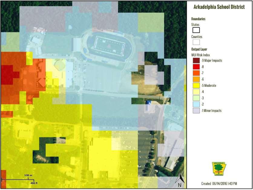
53 Page 53

54 Page 54

55 Page 55

56 Page 56
57 Probability of Future Wildfire Occurrences There is a 10% chance of a Wild Fire event occurring in any given year. Impact and Vulnerability of Wildfire Wildland fires not only consume forest and rangeland vegetation, but impact wildlife habitat, recreation and tourism, water quality and supply and property values. Wildfires can cause extensive damage, both to property and human life. In Clark County, most rural residents depend on their local volunteer fire departments to protect their property from loss. In drought conditions, wildfires can be easily started and are extremely dangerous. Protecting structures in the wildland from fires poses special problems, and put additional burdens on local firefighting resources. Weather conditions leading to wildfires can change rapidly. Thus, there are few measures, other than rapid-response, that can contain wildfires and limit their threat to property. Local economic impacts from catastrophic wildfires include disruptions to both consumption and production of local goods and services. Immediate effects may include decreased recreation / tourism and timber harvest in the fire region, as well as disruptions from evacuations and transportation delays. Increased use of local goods and services for fire protection also impacts local economies. Other effects include direct property losses (in the form of buildings, timber, livestock, and other capital), damage to human health, and possible changes in the long-term structure of the local economy. There are many secondary effects to wildfire. All vegetation may be destroyed as well as the organic material in the soil may be burned away or may decompose into water repellent substances that prevent water from absorbing into the soil. In effect, normal rainfall after a wildfire may result in unusual erosion or flooding from burned areas; depending on the topography of the burned area, heavy rain can produce destructive debris flows. Wildfires also have an effect on water supplies. The loss of ground-surface cover, such as pine needles and small branches, and the chemical transformation of burned soils make watersheds more susceptible to erosion from rainstorms. Page 57

58 It is likely that Clark County will continue to experience wildfire hazards due to the three primary factors wildfires are based on: fuel, topography, and weather. Though most wildfires typically affect only grass and wood-lands with no damage to property or loss of lives, the threat of wildfires to homes and other structures is often high during certain times of the year and under certain conditions. As residential growth increases in the rural areas of the county, the likelihood of wildfires causing property damage and possibly injuries grows. Good fire protection coverage is provided throughout the county by rural fire departments, which do an excellent job of responding to and minimizing the damage of wildfires. The county is also planning to establish the State Forestry s Firewise program, which is intended to educate residents on the dangers of wildfires and on mitigating measures to take. Participation in the Firewise program will also help the county quantify the number of structures in the county that are vulnerable to wildfire The entire County possesses some type of fuel, whether grass, agriculture, forestry, shrubs, structures, or other vegetation types. The upper portion of the county is also located in timber plantations and higher population areas and local businesses, which makes this area of the county a higher risk to wildfires. Structure location is the primary control on vulnerability to wildfire. Structures most vulnerable to wildfire are those located within the wildland-urban interface and wildland-urban intermix. These are areas where structures and other human development meet or intermix with undeveloped wildland. The WUI creates an environment in which fire can move readily between structural and vegetation fuels. Its expansion in recent years has increased the likelihood that Page 58

59 wildfires will threaten structures and people. Although all building construction types within the WUI are vulnerable, the most vulnerable construction type is wood frame, which comprises approximately 65-70% of the structures in the county. For future plan updates, Clark County would like to have more details for what is vulnerable to wildfire and will work with communities to improve database inventory for structure types within the county at the local level Winter Storm Description of Winter Storm Severe winter storms, which may include heavy snowfall, sleet, freezing rain, or a mix of these wintry forms of precipitation. Severe winter weather can down trees, cause widespread power outages, damage property, and cause fatalities and injuries Location of Winter Storm Events All participating jurisdictions of Clark County including the cities of Amity, Arkadelphia, Caddo Valley Gum Springs, Gurdon, Okolona, Whelen Springs, and the school districts of Arkadelphia and Gurdon and Universities including Henderson State University and Ouachita Baptist University are affected by winter storm events. There is no geographical boundary. Extent, Magnitude or Severity of Winter Storms Typical ice storm accumulations range from 1/10 of one inch to ½ of an inch. When severe winter storm events do occur (the worse typically associated with ice), they are usually wide-spread over the area. Snow accumulates up to 14 inches. Probability of Future Winter Storms There is a 12% chance of a winter storm and a 7% chance of an Ice Storm occurring in any given year Impact and Vulnerability of Winter Storms Clark County experiences a major winter storm about every few years, with sometimes multiple occurring in a single year. Damage from of winter storms is often not reported to public agencies for recording in databases such as SHELDUS, typically because the damage is not widespread and usually amounts to no more than downed tree limbs and utility-lines and closed schools and businesses caused by icy road conditions. Based on past experience, an estimated twenty to thirty structures might be impacted in any given year by severe winter storm events, resulting typically in only minor damage to the structures, mainly due to limbs breaking and falling on roofs. Winter storms can immobilize an entire county. Six inches of unplowed snow can make roads impassable. Trees can be brought down by the weight of wet snow, snap power lines and damage buildings and houses when they fall. Winter storms can cut off heat, power and communications for several days or weeks. Death can occur from hypothermia. Page 59
60 Winter storms with freezing rain create a coating of ice which snaps tree branches, down power lines, ruin crops, and makes driving hazardous. Rural areas are most at risk of losing power and becoming isolated during a winter storm. Winter storms can be accompanied by strong winds creating blizzard conditions with blinding wind driven snow, severe drifting, and dangerous wind chill. Strong winds with these intense storms and cold fronts can knock down trees, utility poles, and power lines. Extreme cold often accompanies a winter storm; exposure to the cold can cause frostbite or hypothermia and be lifethreatening. Infants and elderly people are most susceptible. Freezing temperatures can cause severe damage to crops and other vegetation. Pipes may freeze and burst in homes or businesses that are poorly insulated or without heat. Structure fires occur more frequently in the winter due to lack of proper safety precautions and present a greater danger because water supplies may freeze, and impede firefighting efforts. People die of hypothermia from prolonged exposure to the cold. Elderly people are most vulnerable to winter storms and account for the largest percentage of hypothermia victims largely due to improperly or unheated homes, but the leading cause of death during winter storms is from automobile or other transportation accidents. Heavy accumulations of ice can bring down trees, electrical wires, telephone poles and lines, and communication towers. Communications and power can be disrupted for days while utility companies work to repair the extensive damage. Even small accumulations of ice may cause extreme hazards to motorists and pedestrians. Heavy snow can immobilize an area and paralyze a city, stranding commuters, stopping the flow of supplies, and disrupting emergency services. Large amounts of snow can collapse buildings and knock down trees and power lines. In rural areas, homes and farms may be isolated for days, and unprotected livestock may be lost. The cost of snow removal, repairing damages, and loss of business can have large economic impacts on cities and towns. According to National Climatic Data Center (NCDC) and National Weather Service Data, typical snow accumulations in Clark County during heavy snow and winter storm events ranges from 4 inch to 14 inches. Typical ice storm accumulations range from 1/10 of one inch to 1/2 of an inch. Only two severe winter storm events, the December 12 th, 2000 to January 8 th, 2001 Severe Winter Storm (FEMA 1354-DR) and December 25 th 26th, 2012 Severe Winter Storm (FEMA DR-4100), have resulted in a Presidential Disaster Declaration in Clark County. When severe winter storm events do occur (the worse typically associated with ice), they are usually wide-spread over the area and impede the movement of vehicles limiting regular movement of traffic, causing accidents and limiting responsiveness of emergency services and can down power and communications lines and seriously damage some structures, thus creating potentially critical conditions for the entire area. The School Districts officials of Arkadelphia and Gurdon monitor weather updates via television, radio and internet. If weather becomes hazardous, as determined by the superintendent, then appropriate actions are taken based on students being in school or getting ready to come to school. There is not an actual policy on implement weather; the school administrators use their judgment decision as to closing school due to implement weather. If weather is due to snow or ice, and either is forecasted to become hazardous, by the determination of the school official s school may be cancelled. If weather becomes hazardous after school has started school officials may dismiss school early, if road conditions are safe to do so. Students may be kept inside by the determination of the building principals if there are extreme cold temperatures. Wind chill would be the determining factor in keeping students inside. Some districts initiate monitoring for wind chill is below 32 degrees, some 40 degrees. The unincorporated areas of Clark County, cities of Amity, Arkadelphia, Caddo Valley, Gum Springs, Gurdon, Okolona, Whelen Springs and school districts of Arkadelphia and Gurdon and Universities including Henderson State University and Ouachita Baptist University are equally affected by winter storms. Winter storms do not seem to be unique to particular areas of the county; the threat is considered to be countywide with no significant variation at the county or jurisdiction levels. All parts of Clark County are equally susceptible to severe winter storms events. The occurrence of severe winter storms can have a substantial impact on public and private buildings, utility systems, transportation systems, and Page 60
61 agriculture. Heavy accumulations of ice or snow commonly result in collapse of structural damage to buildings. Then damage may be caused directly by the excessive weight of the ice/snow accumulation, or by ice-laden trees or branches falling on structures. Homes, businesses, as well as weaker nonresidential structures are most vulnerable to this type of structural damage. The abundant wood structures and manufactured houses in the planning area are much more vulnerable than steel, concrete, or masonry structures. Past storms indicate that poultry houses are particularly vulnerable. Heavy accumulations of ice from ice storms or heavy snow can bring down trees, electrical wires, telephone poles and lines, and communication towers. Communication and power can be disrupted for days or weeks while utility companies repair the damage. Power and communication disruptions are common consequences of ice storms and heavy snow in Clark County. Winter storms are sometimes accompanied by strong winds. These winds can knock down trees, utility poles and power lines. Clark County s transportation systems are vulnerable to severe winter storms. These storms have rarely been hazardous to structural damage in the past, but accumulations of ice and snow can be extremely hazardous to motorist. Motorist in Clark County are not accustomed to driving on icy roads, causing an increase in traffic accidents. Travel is hampered by ice or heavy snow because Clark County may lack the necessary snow removal equipment due to the occurrence at which severe winter storms do occur. The entire county is usually affected when a winter storm hits Clark County. Parts of the county may not be affected as bad as others, but when major roads are affected, it affects the travel flow and the availability of essential services throughout the county. Page 61
62 SECTION 4-Task 6 Mitigation Strategy Mitigation Goals and Objectives for Each Hazard Based upon the results of the local and State risk assessments, the Clark County Hazard Mitigation Planning Team, with input from local jurisdictions and officials, developed hazard mitigation goals and objectives and selected those that were determined to be of greatest benefit. These goals and objectives represent what Clark County believes is a long-term vision for reduction and enhancement of mitigation capabilities: Goal 1- Reduce the potential for loss of life, injury and economic damage created by exposure to natural hazard for residents of Clark County due to natural disasters. Goal 2- Provide a framework and coordination to encourage all levels of government and public and private organizations to undertake mitigation to minimize potential disasters and to employ mitigation in the recovery following disasters. Goal 3- Seek grants for mitigation projects through the State and Federal funding. Goal 4- Protect existing properties from natural disasters. Implementation of Mitigation Actions The mitigation actions are prioritized based upon their effect on the overall risk to life and property. Ease of implementation, community and agency support and ease of obtaining funding. The County and participating jurisdictions have used the STAPLEE method to prioritize mitigation actions. This method has the benefit that the Mitigation actions are considered in discrete categories of Social, Technical, Administrative, Political, Economic and Environmental. Prioritization can therefore be made taking each of these categories into account, so that nothing is overlooked when considering which actions may be best for each jurisdiction to consider. Criteria used for prioritization and review of mitigation actions based on STAPLEE Evaluation Category Social Technical Administrative Political Legal Economic Sources of Information Members of Local governments and the Clark County Government were members of the Hazard Mitigation Planning Team and had input throughout the planning process. It must be noted that many small town political leaders are also business or professional persons. They are also members of the LEPC. Existing community plans were and will be relied on wherever possible. Members of the media were contacted and invited to all attend all HMPT meetings. The following persons/agencies were consulted as to the technical feasibility of the various projects: Arkansas Geological Commission, University of Arkansas Extension Service, Arkansas Soil and Water Conservation Commission, Arkansas Health Department, Arkansas Highway and Transportation Department, Arkansas Department of Environmental Quality, Arkansas Governor s Pre-Disaster Advisory Council, Arkansas Governor s Earthquake Advisory Council, and Arkansas Forestry Service. Arkansas Department of Emergency Management. All of these had their comments and suggestions incorporated. Staffing for proper implementation of the plan currently will rely largely on existing members of the various agencies involved. Technical assistance is available from various local and state agencies. Some local jurisdictions have incorporated Hazard Mitigation efforts into their Capital Improvement Plans. Operations costs are under discussion by the appropriate agency or department heads. The County Quorum Court has passed resolutions in support of mitigation activities involving floodplain ordinances, mitigation planning, and fire districts, among others. The Governor of Arkansas issued an Executive Order in August of 2004 (EO 04-02) instructing all state agencies to assist ADEM in mitigation planning and implementation of mitigation goals. Members of the HMPT discussed legal issues, and it was their opinion that no significant legal issues were involved in the projects that were selected by the HMPT. However, where legalities may be an issue, this is noted. Economic and benefit cost issues were the predominant topics discussed by all concerned. Each entity felt that the projects selected would have positive effects, but yet realized that actions often have costs, sometimes hidden, imposed on the community, residents and businesses. Funding for the various activities was a major concern as local budgets are always under pressures with existing and competing projects and activities. Where necessary, particularly for costly Page 62
63 Environmental capital projects, outside grants would be relied on heavily. The Arkansas Geological Survey, Arkansas Department of Environmental Quality, Arkansas Forestry Commission, and Arkansas Soil and Water Conservation Commission were all consulted as to the environmental impact of the various projects and it was felt that there would be no negative impact. Local environmental issues and concerns were also taken into consideration. The Clark County Office of Emergency Management is responsible for evaluating actions among competing actions. The Planning Team prioritized the list of mitigation actions by conducting a cost-benefit review. This review was conducted by; first considering the number of people who would be affected by a chosen project, determining the area the project would cover, considering how critical the structures were within in the project area, and which structure were most critical, and finally how would it benefit the entire community. The () shall evaluate actions based on funding availability, comparative value to mitigation objectives, and consideration of economic benefits and environmental concerns of the communities. Actions are prioritized in three different categories; High need for immediate action, Medium need for action, Low lacking in urgency. All Clark County actions and planning mechanisms are the responsibility of the director of the Clark County Office of Emergency Management. The Cities of Amity, Arkadelphia, Caddo Valley, Gum Springs, Gurdon, Okolona and Whelen Springs actions and planning mechanisms are the responsibility of their Mayors. The School Districts of Arkadelphia and Gurdon will be the responsibility of their School Board Administration. Henderson State University and Ouachita Baptist University will be the responsibility of their Board of Directors and/or University President. The Responsible Agency for each mitigation action will identify resources. Their responsibility will be to examine resources from all levels of government. The responsible parties will integrate the requirements of the mitigation plan into other plans when appropriate. This also, includes funding and support for enacting and enforcing building codes and zoning ordinances, and developing public education programs to alert residents to risks and how they can reduce hazard losses. Plans will be made to earmark resources for implementing these actions. Each jurisdiction and school district within the County that participated in the planning process has at least two actions that will benefit the jurisdiction. For the purpose of developing the Clark County Hazard Mitigation Plan, mitigation actions are categorized into six groups; Actions that will keep problems from getting worse (Prevention). Actions that address individual buildings (Property protection) Actions that will inform the public (Public education and awareness) Actions that will protect natural resources (Natural resource protection) Actions that will protect emergency services before, during, and immediately after an occurrence (Emergency services protection) Actions that will control the hazard (Structural projects) Page 63
64 Applicable to New/Existing Buildings and Infrastructure Hazard Addressed Countywide School District/Henderson and Ouachita Baptiist Universities Caddo Valley Gum Springs District Okolona Whelen Springs Mitigation Action Completed - Action Not Completed - X APA 2/15/17 Progress in Local Mitigation Efforts Mitigation Actions Amity Amity elementary Arkadelphia- Arkadelphia Gurdon-Gurdon School Acquire reliable and current information relating to existing and new buildings and infrastructure, especially critical facilities. Provide residents with ways to recognize signs of impending dam failure. Establish burn restriction and water conservation measures for localized drought conditions. Increase public awareness of drought risks and measures the public can take to reduce risk. Increase public awareness of earthquake threat and NOAA weather radio Design new buildings in ways that reduce the impact of ground shaking. Community organized outreach to vulnerable population during periods of extreme temperature, including establishing and promoting assessable cooling centers in the community. City officials and community leaders can encourage utility companies to offer special arrangements for paying utility bills. Establish shelters for vulnerable, specialneeds, and at-risk population for use during disaster. New and Existing New and Existing Dam Failure Dam Failure X Existing Drought X Existing Drought New and Earthquake Existing New Earthquake Existing Extreme Heat N/A New and Existing Extreme Heat Extreme Heat X X X X X Sponsor a Helping Your Neighbor program through local schools and fire department to assist the needs of persons who require special assistance such as elderly people, infants or people with disabilities during extreme heat conditions. Identify sources of water in the area (small ponds, cisterns, wells, pools, hydrants, etc.) for appropriate use during disaster. Public information on all-hazard radios for all schools, city halls, large N/A Extreme Heat N/A New and Existing Extreme Heat Flood X X Page 64
65 businesses, churches, and other locations where large groups of people gather. Storm Water drainage ordinances Acquire generators for all County shelters, city halls, emergency centers, fire and health dept and other critical facilities All communities should join the National Flood Insurance Program Improve public awareness of tornado and high wind risks, safe rooms, wind construction methods, safe zones around the home, and NOAA weather radio warning system. New and Existing New and Existing Flood Flood N/A Flood New and Existing Tornado- High Winds Assess current warning system Existing Tornado- High Winds Seek funding to provide NOAA weather radios at reduced cost. New and Existing Tornado- High Winds Seek funding to provide safe rooms for New and Tornado schools, universities and critical facilities Existing High Winds Trim trees to reduce wind damages. Existing Tornado- High Wind Improve public awareness of lightning New and Thunderstorm and hail risk, measures that can be taken Existing -Lightening to reduce risk (trimming trees, purchasing Hail generators) and community warning systems (sirens and NOAA weather radio) Local ordinances can require burn permits and restrict campfires and outdoor burning. All communities should join Fire Wise Program at firewise.org Distribute FEMA information through Clark County OEM and local insurance companies on the importance of tree pruning as a deterrent to wildland fires, Increase public awareness of winter storms hazards and risk and measures they can take to reduce risks, including weatherizing homes, protecting pipes from freezing, and recommended snow load building standards. New and Existing Wildfire N/A Wildfire New and Existing New and Existing Wildfire Winter Storms Promote NOAA weather radios New and Existing Winter Storms Establish tree-trimming programs. Existing Winter Storms Identify vulnerable populations who may Existing Winter require special assistance. Storms Acquire generators for shelters, city halls, New and ALL emergency operations centers, and other Existing critical facilities. * Note Actions that were not completed however are still a priority for the participating jurisdictions will be listed in section 4.4 which deal with current mitigation actions. The planning team may add and update this list as needed during each yearly update period at the local level. Page 65 X X X X X X X X X X X X X X
66 4.4 Mitigation Actions/Projects Mitigation Actions Multi-Hazard Events Prepare and adopt an Outdoor Warning Sirens Plan, including consideration of the unique geographic locations, technical requirements, system types and operational procedures of each local jurisdiction. These plans will include a review of existing outdoor warning siren coverage and recommend new locations if and where there are coverage gaps. Install new warning sirens in accordance with plan recommendations. Associated Hazard: Tornado, Dam Failure Type of Action: Prevention Contribution to Mitigation Objective: Protect lives by alerting congregations of people of impending disasters. Priority: Medium Rationale for Priority: Past Disasters Addresses new or existing buildings: New and Existing Cost Benefit: Highly beneficial, cost to county TimeLine: Ongoing Projected Resources: Existing County Responsible Party: Clark County, Cities of Amity, Arkadelphia, Caddo Valley, Gum Springs, Gurdon, Okolona, Whelen Springs Mitigation Action adopted by: Clark County, Cities of Amity, Arkadelphia, Caddo Valley, Gum Springs, Gurdon, Okolona, Whelen Springs STAPLEE: Meets all Criteria Implement Code RED weather warning early telephone warning system designed to automatically deliver targeted weather notification for the immediate threats of severe weather events with moments of being issued by the National Weather Service (NWS) throughout Clark County. Associated Hazard: Flood, Thunderstorm, Tornado, Winter storms, Earthquake, Dam Failure, Wildfire Type of Action: Prevention Contribution to Mitigation Objective: Prevents the loss of lives by alerting citizens by landline or cell phone of approaching storms by physical address. Priority: High Rationale for Priority: Past Storm Events Addresses new or existing buildings: N/A Cost Benefit: Highly Beneficial TimeLine: Ongoing Projected Resources: Existing county and possible outside sources Responsible Party: Clark County, Cities of Amity, Arkadelphia, Caddo Valley, Gum Springs, Gurdon, Okolona, Whelen Springs Mitigation Action adopted by: Clark County, Cities of Amity, Arkadelphia, Caddo Valley, Gum Springs, Gurdon, Okolona, Whelen Springs STAPLEE: Meets all criteria Page 66
67 Burying or otherwise protecting electric and other utility lines or prevent disruption by protecting lines from ice, wind, snow, high winds, and tornadoes. Associated Hazard: Thunderstorm, Tornado, Winter Storm, Ice Storm, Type of Action: Prevention Action Contribution to Mitigation Objective: Prevents the loss of electrical power to critical facilities, homes, and communication systems. Priority: High Rationale for Priority: Past Disasters Addresses new or existing buildings: New and Existing Cost Benefit: Highly Beneficial, Cost to owner of right-of-ways TimeLine: Ongoing Projected Resources: County and Local Responsible Party: Local Utility Companies Mitigation Action adopted by: Clark County, Cities of Amity, Arkadelphia, Caddo Valley, Gum Springs, Gurdon, Okolona, Whelen Springs STAPLEE: Meets all Criteria Install NOAA weather radios in all public buildings where large numbers of people congregate. Associated Hazard: Dam Failure, Drought, Earthquake, Extreme Heat, Flood/Flash Flood, Thunderstorms, Tornado, Wildfire, Winter Storms/Ice Storms Type of Action: Prevention Contribution to Mitigation Objective: Protect lives by alerting congregations of people about impending disasters. Priority: High Rationale for Priority: Past Disasters Addresses new or existing buildings: New and Existing Cost Benefit: If action proves effective in influencing others to obtain radio, benefits will greatly outweigh cost. TimeLine: Ongoing Projected Resources: County, Cities, and School Districts Responsible Party: Clark County, Cities of Amity, Arkadelphia, Caddo Valley, Gum Springs, Gurdon, Okolona, Whelen Springs and school districts of Arkadelphia and Gurdon, as well as Henderson State and Ouachita Baptist. Mitigation Action adopted by: Clark County, Cities of Amity, Arkadelphia, Caddo Valley, Gum Springs, Gurdon, Okolona, Whelen Springs and school districts of Arkadelphia and Gurdon, as well as Henderson State and Ouachita Baptist. STAPLEE: Meets all Criteria Install heavy duty generators to back up and maintain electrical power for critical facilities, schools and shelters to maintain power and water supply during disasters. Associated Hazard: Dam Failure, Drought, Earthquake, Extreme Heat, Flood, Lightning, Thunderstorms, Tornado, Wildfires, Winter Storms, Ice Storms Type of Action: Emergency Services Protection, Critical Infrastructure Protection Contribution to Mitigation Objective: Continuation of Water Services, Continuation of Critical Services, and Temperature control for shelters and critical facilities. Priority: High Rationale for Priority: Past Disasters Addresses new or existing buildings: New and Existing Cost Benefit: Cost varies on size and type of generator TimeLine: Ongoing Projected Resources: County, Cities, and school districts Responsible Party: Clark County, Cities of Amity, Arkadelphia, Caddo Valley, Gum Springs, Gurdon, Okolona, Whelen Springs and school districts of Arkadelphia and Gurdon, as well as Henderson State and Ouachita Baptist. Mitigation Action adopted by: Clark County, Cities of Amity, Arkadelphia, Caddo Valley, Gum Springs, Gurdon, Okolona, Whelen Springs and school districts of Arkadelphia and Gurdon, as well as Henderson State and Ouachita Baptist. STAPLEE: Meets all Criteria Page 67
68 Use newspapers, local radio stations and websites to promote the use of Weather Apps for iphone and smart phones. Associated Hazard: Dam Failure, Drought, Earthquake, Extreme Heat, Flood / Flash Flood, Thunderstorms, Tornado, Wildfire, Winter Storms/Ice Storms Type of Action: Prevention Contribution to Mitigation Objective: Educate public about threats the area may face. Priority: High Rationale for Priority: Past Disasters Addresses new or existing buildings: N/A Cost Benefit: Highly Beneficial/ little to no cost TimeLine: Ongoing Projected Resources: County, Cities, and School Districts Responsible Party: Clark County, Cities of Amity, Arkadelphia, Caddo Valley, Gum Springs, Gurdon, Okolona, Whelen Springs and school districts of Arkadelphia and Gurdon, as well as Henderson State and Ouachita Baptist. Mitigation Action adopted by: Clark County, Cities of Amity, Arkadelphia, Caddo Valley, Gum Springs, Gurdon, Okolona, Whelen Springs and school districts of Arkadelphia and Gurdon, as well as Henderson State and Ouachita Baptist. STAPLEE: Meets all Criteria Create a data base to track individuals at high risk of death such as the elderly, homeless and special needs etc. Associated Hazard: Dam Failure, Earthquake, Extreme Heat, Winter/Ice Storms, Tornadoes, Flooding, Wildfires, Drought Type of Action: Prevention Contribution to Mitigation Objective: Reduces the risk of lives due to hazards Priority: High Rationale for Priority: Past Disasters Addresses new or existing buildings: Na Cost Benefit: Highly Beneficial, little to no cost TimeLine: 1 year Projected Resources: County, Cities Responsible Party: Clark County, Fire Departments Mitigation Action adopted by: Clark County, Fire Departments STAPLEE: Meets all Criteria Provide emergency preparedness information and resource for extreme weather conditions and mitigation activities through an active education outreach programs with specific plans and procedures for at risk populations. Associated Hazard: Dam Failure, Drought, Earthquake, Extreme Heat, Flood, Thunderstorms, Tornado, Wildfire, Winter/Ice Storms Type of Action: Public Education and Outreach Contribution to Mitigation Objective: Prevents loss of life and property by preparing at risk populations for possible hazards. Priority: Medium Rationale for Priority: Inform the public prior to hazards Addresses new or existing buildings: N/A Cost Benefit: Beneficial, at little cost TimeLine: Ongoing Projected Resources: FEMA Brochures, Time Responsible Party: Clark County office of Emergency Management, Campus Public Safety Mitigation Action adopted by: Clark County, Cities of Amity, Arkadelphia, Caddo Valley, Gum Springs, Gurdon, Okolona, Whelen Springs and school districts of Arkadelphia and Gurdon, as well as Henderson State and Ouachita Baptist. STAPLEE: Meets all Criteria Page 68
69 Construct safe rooms within new and existing public buildings, such as schools, libraries and community centers Associated Hazard: Thunderstorm Winds, Tornadoes Type of Action: Structural Project Contribution to Mitigation Objective: Prevents the loss of life by providing shelter during pre/post disaster. Priority: High Rationale for Priority: Prevents the loss of life during storms and also minimizes the effects post hazards. Ranked high dud to past storm events. Addresses new or existing buildings: New and existing Cost Benefit: Benefits outweigh cost. Possible grants for construction TimeLine: Ongoing Projected Resources: HMGP, PDM funding Responsible Party: Clark County, Cities of Amity, Arkadelphia, Caddo Valley, Gum Springs, Gurdon, Okolona, Whelen Springs and school districts of Arkadelphia and Gurdon, as well as Henderson State and Ouachita Baptist. Mitigation Action adopted by: Clark County, Cities of Amity, Arkadelphia, Caddo Valley, Gum Springs, Gurdon, Okolona, Whelen Springs and school districts of Arkadelphia and Gurdon, as well as Henderson State and Ouachita Baptist. STAPLEE: Meets all Criteria Use GIS to map hazard areas, at-risk structures and associated hazards to assess high risk areas. Associated Hazard: Earthquake, Flood, and Wildfire Type of Action: Prevention Contribution to Mitigation Objective: Reduces the risk to lives due to hazardous events Priority: High Rationale for Priority: Pin points areas that are at risk to earthquakes, flooding, and wildfires. Addresses new or existing buildings: New and Existing Cost Benefit: Highly Beneficial, Little Cost TimeLine: 2 years Projected Resources: County Funds Responsible Party: Clark County Office of Emergency Management Mitigation Action adopted by: Clark County STAPLEE: Meets all Criteria Purchase and install emergency back-up generators in all public buildings where safe rooms are installed and at public utilities to maintain emergency functionality during power outages. Associated Hazard: Dam Failure, Extreme Heat, Flood, Lightning, Thunderstorms, Tornado, Wildfires, Winter Storms, Ice Storms Type of Action: Emergency Services Protection, Critical Infrastructure Protection Contribution to Mitigation Objective: Continuation of Water Services, Continuation of Critical Services, and Temperature control for shelters and critical facilities. Priority: High Rationale for Priority: Past Disasters Addresses new or existing buildings: New and Existing Cost Benefit: Cost varies on size and type of generator TimeLine: Ongoing Projected Resources: County, Cities, and school districts Responsible Party: Clark County, Cities of Amity, Arkadelphia, Caddo Valley, Gum Springs, Gurdon, Okolona, Whelen Springs and school districts of Arkadelphia and Gurdon, as well as Henderson State and Ouachita Baptist. Mitigation Action adopted by: Clark County, Cities of Amity, Arkadelphia, Caddo Valley, Gum Springs, Gurdon, Okolona, Whelen Springs and school districts of Arkadelphia and Gurdon, as well as Henderson State and Ouachita Baptist. STAPLEE: Meets all Criteria Page 69
70 Purchase and install emergency back-up lightning in all public shelters and safe room that do not already have them. Associated Hazard: Flood, Lightning, Thunderstorms, Tornado, Winter Storms, Ice Storms Type of Action: Prevention Contribution to Mitigation Objective: Allows for the safe passage out of facilities during power failure. Priority: High Rationale for Priority: Past Disasters Addresses new or existing buildings: New and Existing Cost Benefit: Cost varies TimeLine: Ongoing Projected Resources: County, Cities, and school districts, Colleges Responsible Party: Clark County, Cities of Amity, Arkadelphia, Caddo Valley, Gum Springs, Gurdon, Okolona, Whelen Springs and school districts of Arkadelphia and Gurdon, as well as Henderson State and Ouachita Baptist. Mitigation Action adopted by: Clark County, Cities of Amity, Arkadelphia, Caddo Valley, Gum Springs, Gurdon, Okolona, Whelen Springs and school districts of Arkadelphia and Gurdon, as well as Henderson State and Ouachita Baptist. STAPLEE: Meets all Criteria Apply window film to windows at public schools and public buildings as able to prevent shattering. Associated Hazard: Earthquakes, Thunderstorms, Tornadoes Type of Action: Prevention Contribution to Mitigation Objective: reduces the risk of injuries from broken glass. Priority: Medium Rationale for Priority: Past events Addresses new or existing buildings: New and existing Cost Benefit: Highly Beneficial, at little cost TimeLine: 3 years Projected Resources: County, City, School, and Possible Grant funds Responsible Party: Clark County, Cities of Amity, Arkadelphia, Caddo Valley, Gum Springs, Gurdon, Okolona, Whelen Springs and school districts of Arkadelphia and Gurdon, as well as Henderson State and Ouachita Baptist. Mitigation Action adopted by: Clark County, Cities of Amity, Arkadelphia, Caddo Valley, Gum Springs, Gurdon, Okolona, Whelen Springs and school districts of Arkadelphia and Gurdon, as well as Henderson State and Ouachita Baptist. STAPLEE: Meets all Criteria Dam Failure Conduct or gather inundation data in regards to dam failures in the county and participating jurisdictions. Associated Hazard: Dam Failure Type of Action: Prevention Contribution to Mitigation Objective: reduces the risk of injuries or death due to dam failure. Priority: Medium Rationale for Priority: Risk Addresses new or existing buildings: NA Cost Benefit: Highly Beneficial, cost outweigh risk TimeLine: ongoing Projected Resources: County, City, and Possible Grant funds Responsible Party: Clark County, Cities of Amity, Arkadelphia, Caddo Valley, Gum Springs, Gurdon, Okolona, Whelen Springs Mitigation Action adopted by: Clark County, Cities of Amity, Arkadelphia, Caddo Valley, Gum Springs, Gurdon, Okolona, Whelen Springs STAPLEE: Meets all Criteria Page 70
71 Drought Actions Pass Ordinance to regulate the times when watering of gardens is allowable. Associated Hazard: Drought Type of Action: Prevention Contribution to Mitigation Objective: Reduce the amount of water that will be used for nonessential task. Priority: High Rationale for Priority: Past events in area and around the world. Addresses new or existing buildings: New and existing Cost Benefit: Highly Beneficial, no cost TimeLine: As needed Projected Resources: County Responsible Party: Clark County Mitigation Action adopted by: Clark County STAPLEE: Meets all Criteria Implement an outreach program directed at agriculture community to include programs that educate farmers on benefits of buying crop insurance mitigation actions and the economic effects of prolonged drought. Associated Hazard: Drought Type of Action: Public Education and Awareness Contribution to Mitigation Objective: Educates public on how to minimalize losses Priority: High Rationale for Priority: The possibility of drought affecting the area. Addresses new or existing buildings: N/A Cost Benefit: Highly Beneficial TimeLine: Ongoing Projected Resources: County, City s, and Federal Responsible Party: Clark County, Cities of Amity, Arkadelphia, Caddo Valley, Gum Springs, Gurdon, Okolona, Whelen Springs Mitigation Action adopted by: Clark County, Cities of Amity, Arkadelphia, Caddo Valley, Gum Springs, Gurdon, Okolona, Whelen Springs STAPLEE: Meets all Criteria Page 71
72 Earthquake Support financial incentives, such as low interest loans or tax breaks for home and business owners who seismically retrofit their structures. Associated Hazard: Earthquake Type of Action: Prevention Contribution to Mitigation Objective: Helps to build structures to seismic standards. Priority: Low Rationale for Priority: Earthquakes have occurred in the past. Addresses new or existing buildings: new and existing Cost Benefit: beneficial TimeLine: Ongoing Projected Resources: County Responsible Party: Clark County Mitigation Action adopted by: Clark STAPLEE: Meets al Criteria Extreme Heat Encourage installation of green roofs, which provide shade and remove heat from roof surface and surrounding air. Associated Hazard: Extreme Heat Type of Action: Prevention Contribution to Mitigation Objective: Seeks to decrease the temperature within facilities Priority: Medium Rationale for Priority: Decreases the amount of heat within a facility. Addresses new or existing buildings: New and existing Cost Benefit: Highly Beneficial TimeLine: Ongoing Projected Resources: N/A Responsible Party: Clark County, Cities of Amity, Arkadelphia, Caddo Valley, Gum Springs, Gurdon, Okolona, Whelen Springs and school districts of Arkadelphia and Gurdon, as well as Henderson State and Ouachita Baptist. Mitigation Action adopted by: Clark County, Cities of Amity, Arkadelphia, Caddo Valley, Gum Springs, Gurdon, Okolona, Whelen Springs and school districts of Arkadelphia and Gurdon, as well as Henderson State and Ouachita Baptist. STAPLEE: Meets all Criteria Establish and promote accessible cooling centers/shelters for vulnerable, special-needs, and at risk populations. Associated Hazard: Extreme Heat Type of Action: Prevention Contribution to Mitigation Objective: Provides sheltering for vulnerable, special-needs, and at risk populations during extreme heat events. Priority: High Rationale for Priority: Past Events Addresses new or existing buildings: New and exiting Cost Benefit: Highly Beneficial, Little to no Cost TimeLine: Ongoing Projected Resources: County and local resources Responsible Party: Clark County, Cities of Amity, Arkadelphia, Caddo Valley, Gum Springs, Gurdon, Okolona, Whelen Springs Mitigation Action adopted by: Clark County, Cities of Amity, Arkadelphia, Caddo Valley, Gum Springs, Gurdon, Okolona, Whelen Springs STAPLEE: Meets all Criteria Page 72
73 Flood For critical facilities and public buildings-keep water out by strengthening walls, sealing openings, and/or using waterproof compounds or plastic sheeting on walls. This is intended for non-residential structures-either in new construction, while making a substantial improvement, or while repairing a substantially damaged structure. Associated Hazard: Flood/Flash Flood Type of Action: Prevention and Structural Contribution to Mitigation Objective: Will guard critical facilities from receiving water damage. Priority: High Rationale for Priority: Past Disasters Addresses new or existing buildings: New and Existing Cost Benefit: Highly Beneficial TimeLine: 3 years Projected Resources: County, City, School Responsible Party: Clark County, Cities of Amity, Arkadelphia, Caddo Valley, Gum Springs, Gurdon, Okolona, Whelen Springs and school districts of Arkadelphia and Gurdon, as well as Henderson State and Ouachita Baptist. Mitigation Action adopted by: Clark County, Cities of Amity, Arkadelphia, Caddo Valley, Gum Springs, Gurdon, Okolona, Whelen Springs and school districts of Arkadelphia and Gurdon, as well as Henderson State and Ouachita Baptist. STAPLEE: Meets all Criteria Set the design flood elevation at or about the historic high water mark if it is about the mapped base flood elevation. Associated Hazard: Flood/Flash Flood Type of Action: Prevention and Structural Contribution to Mitigation Objective: Priority: High Rationale for Priority: Past Disasters Addresses new or existing buildings: New Cost Benefit: Highly Beneficial TimeLine: 1 Year Projected Resources: Federal, County, City Responsible Party: Clark County, Cities of Amity, Arkadelphia, Caddo Valley, Gum Springs, Gurdon, Okolona, Whelen Springs Mitigation Action adopted by: Clark County, Cities of Amity, Arkadelphia, Caddo Valley, Gum Springs, Gurdon, Okolona, Whelen Springs STAPLEE: Meets all Criteria Implement and retrofit construction plans to modify low water bridges in the area that are susceptible to flooding. Associated Hazard: Flood/Flash Flood Type of Action: Prevention and Structural Contribution to Mitigation Objective: Helps to mitigate against bridges being washed out. Priority: High Rationale for Priority: Past Disasters Addresses new or existing buildings: New and Existing Cost Benefit: Highly Beneficial, Benefits outweigh cost TimeLine: Ongoing Projected Resources: County, City, and Possible Grant Funding Responsible Party: Clark County, Cities of Amity, Arkadelphia, Caddo Valley, Gum Springs, Gurdon, Okolona, Whelen Springs Mitigation Action adopted by: Clark County, Cities of Amity, Arkadelphia, Caddo Valley, Gum Springs, Gurdon, Okolona, Whelen Springs STAPLEE: Meets all Criteria Page 73
74 Regulate development in upland areas in order to reduce stormwater run-off; using erosion control techniques that may be employed within a watershed area such are proper ban stabilization with sloping or grading techniques, planting vegetation on slopes, terracing hillsides, or installing riprap boulders or geotextile fabric. Associated Hazard: Flood Type of Action: Prevention Contribution to Mitigation Objective: Helps to protect downhill areas from run off. Priority: High Rationale for Priority: Past Disaster Addresses new or existing buildings: New Cost Benefit: Highly Beneficial, Little to no cost TimeLine: 2 years Projected Resources: County and Cities Responsible Party: Clark County, Cities of Amity, Arkadelphia, Caddo Valley, Gum Springs, Gurdon, Okolona, Whelen Springs Mitigation Action adopted by: Clark County, Cities of Amity, Arkadelphia, Caddo Valley, Gum Springs, Gurdon, Okolona, Whelen Springs STAPLEE: Meets all Criteria Increase capacity for storm drainage by increasing the sizing of all culverts when upgrading roads, bridges and similar county infrastructure. Associated Hazard: Flood Type of Action: Prevention and Structural Contribution to Mitigation Objective: Helps to increase the capacity at which water can flow so that area can drain faster and not flood. Priority: High Rationale for Priority: Past Events Addresses new or existing buildings: New and Existing Cost Benefit: Highly Beneficial, Benefits outweigh Cost TimeLine: Ongoing Projected Resources: State, County, City Responsible Party: Clark County, Cities of Amity, Arkadelphia, Caddo Valley, Gum Springs, Gurdon, Okolona, Whelen Springs Mitigation Action adopted by: Clark County, Cities of Amity, Arkadelphia, Caddo Valley, Gum Springs, Gurdon, Okolona, Whelen Springs STAPLEE: Meets all Criteria Conduct NFIP community workshops to provide information for property owners to acquire flood insurance. Associated Hazard: Flood/Flash Flood Type of Action: Public Education and Outreach Contribution to Mitigation Objective: Educates the public on the importance of flood insurance. Priority: High Rationale for Priority: Flooding has occurred in the past. Addresses new or existing buildings: New and Existing Cost Benefit: Highly Beneficial at no Cost TimeLine: Ongoing Projected Resources: FEMA F-679 online free brochures Responsible Party: County and City Floodplain Management Mitigation Action adopted by: Clark County, Cities of Amity, Arkadelphia, Caddo Valley, Gum Springs, Gurdon, Okolona, Whelen Springs STAPLEE: Meets all Criteria Page 74
75 Acquire properties that are deemed repetitive loss properties or severe repetitive loss properties through mitigation funding. Associated Hazard: Flood Type of Action: Prevention and Structural Contribution to Mitigation Objective: Helps to decrease the number of properties that are located within a flood zone. Priority: High Rationale for Priority: Past Events Addresses new or existing buildings: New and Existing Cost Benefit: Highly Beneficial, Benefits outweigh Cost TimeLine: Ongoing Projected Resources: Federal, State, County, City Responsible Party: Clark County, Cities of Amity, Arkadelphia, Caddo Valley, Gum Springs, Gurdon, Okolona, Whelen Springs Mitigation Action adopted by: Clark County, Cities of Amity, Arkadelphia, Caddo Valley, Gum Springs, Gurdon, Okolona, Whelen Springs STAPLEE: Meets all Criteria Gather new flood data or conduct studies to meet any data deficiencies that were determined in this plan. Associated Hazard: Flood Type of Action: Prevention and Structural Contribution to Mitigation Objective: Helps to increase information in regards to flooding Priority: High Rationale for Priority: Past Events Addresses new or existing buildings: New and Existing Cost Benefit: Highly Beneficial, TimeLine: Ongoing Projected Resources: Federal, State, County, City Responsible Party: Clark County, Cities of Amity, Arkadelphia, Caddo Valley, Gum Springs, Gurdon, Okolona, Whelen Springs Mitigation Action adopted by: Clark County, Cities of Amity, Arkadelphia, Caddo Valley, Gum Springs, Gurdon, Okolona, Whelen Springs STAPLEE: Meets all Criteria Winter and Ice Storms Using designed-failure mode for power line design to allow line to fall or fail in small sections rather than as a complete system to enable faster repairs. Associated Hazard: Winter Storms and Ice storms + Thunder storms Type of Action: Prevention Contribution to Mitigation Objective: Prevents strong winds and ice causing trees from falling on power lines creating power outages to homes, critical facilities, and communication systems Priority: High Rationale for Priority: Past Disasters Addresses new or existing buildings: New and Existing Cost Benefit: Beneficial, Cost to the owner of right-of-ways either County or City TimeLine: Ongoing Projected Resources: Existing County and Local Resources Responsible Party: Local Utility Companies Mitigation Action adopted by: Clark County, Cities of Amity, Arkadelphia, Caddo Valley, Gum Springs, Gurdon, Okolona, Whelen Springs STAPLEE: Meets all Criteria Page 75
76 Trim trees to reduce damage to utilities such as powerlines. Associated Hazard: Winter and Ice Storms Type of Action: Prevention Contribution to Mitigation Objective: Prevents tree limbs from falling on utility lines causing them to loose service Priority: High Rationale for Priority: Past Disasters Addresses new or existing buildings: New and Existing Cost Benefit: Highly Beneficial, Benefits outweigh Cost TimeLine: Ongoing Projected Resources: County, City Responsible Party: Local Utility Companies, Clark County, Cities of Amity, Arkadelphia, Caddo Valley, Gum Springs, Gurdon, Okolona, Whelen Springs, Henderson State University, Ouachita Baptist University Mitigation Action adopted by: Clark County, Cities of Amity, Arkadelphia, Caddo Valley, Gum Springs, Gurdon, Okolona, Whelen Springs, Henderson State University, Ouachita Baptist University STAPLEE: Meets all Criteria Tornado Install tornado-warning sirens across planning area as funds become available Associated Hazard: Tornado Type of Action: Prevention Contribution to Mitigation Objective: Alerts citizens during sever weather events so that they will know to take shelter. Priority: High Rationale for Priority: Past Disasters Addresses new or existing buildings: N/A Cost Benefit: Highly Beneficial, Benefits outweigh Cost TimeLine: Ongoing Projected Resources: County, City, Possible Grant Funding Responsible Party: Clark County, Cities of Amity, Arkadelphia, Caddo Valley, Gum Springs, Gurdon, Okolona, Whelen Springs Mitigation Action adopted by: Clark County, Cities of Amity, Arkadelphia, Caddo Valley, Gum Springs, Gurdon, Okolona, Whelen Springs STAPLEE: Meets all Criteria Thunderstorm Winds, Hail and Lightning Installing and maintaining surge protection to protect against lightning strikes on all critical electronic equipment. Associated Hazard: Thunderstorm, Lightning Type of Action: Prevention Contribution to Mitigation Objective: Prevents critical electronic devices from being damaged due to surge in electricity. Priority: High Rationale for Priority: Past Events Addresses new or existing buildings: New and Existing Cost Benefit: Highly Beneficial, Benefits outweigh Cost TimeLine: 2 years Projected Resources: County, City, Schools Responsible Party: Clark County, Cities of Amity, Arkadelphia, Caddo Valley, Gum Springs, Gurdon, Okolona, Whelen Springs and school districts of Arkadelphia and Gurdon, as well as Henderson State and Ouachita Baptist. Page 76
77 Mitigation Action adopted by: Clark County, Cities of Amity, Arkadelphia, Caddo Valley, Gum Springs, Gurdon, Okolona, Whelen Springs and school districts of Arkadelphia and Gurdon, as well as Henderson State and Ouachita Baptist. STAPLEE: Meets all Criteria Install lightning protection devices and methods such as lightning rods and grounding on communication infrastructure and other critical facilities. Associated Hazard: Thunderstorm, Lightning Type of Action: Prevention, Structural Contribution to Mitigation Objective: Priority: High Rationale for Priority: Past Events Addresses new or existing buildings: New and Existing Cost Benefit: Highly Beneficial, Benefits outweigh Cost TimeLine: 3 years Projected Resources: County, City, Schools Responsible Party: Clark County, Cities of Amity, Arkadelphia, Caddo Valley, Gum Springs, Gurdon, Okolona, Whelen Springs and school districts of Arkadelphia and Gurdon, as well as Henderson State and Ouachita Baptist. Mitigation Action adopted by: Clark County, Cities of Amity, Arkadelphia, Caddo Valley, Gum Springs, Gurdon, Okolona, Whelen Springs and school districts of Arkadelphia and Gurdon, as well as Henderson State and Ouachita Baptist. STAPLEE: Meets all Criteria Wildfire Countywide ordinance to enforce burn bans during drought periods. Associated Hazard: Wildfire Type of Action: Prevention Contribution to Mitigation Objective: Prohibits burning during designated times. Priority: High Rationale for Priority: Past Events Addresses new or existing buildings: New and Existing Cost Benefit: Highly Beneficial, No Cost TimeLine: Ongoing Projected Resources: County Responsible Party: Clark County Mitigation Action adopted by: Clark County STAPLEE: Meets all Criteria Page 77
78 Provide free technical assistance brochures and pamphlets from FEMA, FireWise, and ADEM on potential wildfire mitigation activities for homeowners. Associated Hazard: Wildfire Type of Action: Public Education and Outreach Contribution to Mitigation Objective: Educates the public on Wildfires and the dangers of burning in regards to climate conditions Priority: Medium Rationale for Priority: Past Events Addresses new or existing buildings: New and Existing Cost Benefit: Highly Beneficial, No Cost TimeLine: Ongoing Projected Resources: County, City, School Responsible Party: Clark County, Cities of Amity, Arkadelphia, Caddo Valley, Gum Springs, Gurdon, Okolona, Whelen Springs and school districts of Arkadelphia and Gurdon, as well as Henderson State and Ouachita Baptist. Mitigation Action adopted by: Clark County, Cities of Amity, Arkadelphia, Caddo Valley, Gum Springs, Gurdon, Okolona, Whelen Springs and school districts of Arkadelphia and Gurdon, as well as Henderson State and Ouachita Baptist. STAPLEE: Meets all Criteria Encourage communities to join the Fire Wise Program. Associated Hazard: Wildfire Type of Action: Prevention Contribution to Mitigation Objective: Areas put efforts toward wildfire protection Priority: High Rationale for Priority: Past Events Addresses new or existing buildings: New and Existing Cost Benefit: Highly Beneficial, little Cost TimeLine: Ongoing Projected Resources: County, City Responsible Party: Clark County Mitigation Action adopted by: Clark County, Cities of Amity, Arkadelphia, Caddo Valley, Gum Springs, Gurdon, Okolona, Whelen Springs STAPLEE: Meets all Criteria Page 78
79 Dam Failure Conduct inspections, maintenance and enforce programs on dams to ensure structural integrity. (NFIP consideration, CRS 330 Outreach, CRS 350 Flood Protection Information) Associated Hazard: Dam Failure Type of Action: Prevention Contribution to Mitigation Objective: Conduct Inspections of dams to enforce compliance. Priority: High Rationale for Priority: No Past Dam Failures Addresses new or existing buildings: New and Existing Cost Benefit: Highly Beneficial, Little to no cost TimeLine: Ongoing Projected Resources: Clark County Responsible Party: Clark County Mitigation Action adopted by: Clark County STAPLEE: Meets all Criteria Adopting Ordinances that limit development in areas that could be affected by flooding caused by dam failure. Associated Hazard: Dam Failure Type of Action: Prevention Contribution to Mitigation Objective: Prevent the construction of new homes or facilities in areas that could be affected by dam failure. Priority: High Rationale for Priority: No Past Dam Failures Addresses new or existing buildings: New Cost Benefit: Highly Beneficial, No Cost TimeLine: N/A Projected Resources: Clark County Responsible Party: Clark County, Cities of Amity, Arkadelphia, Caddo Valley, Gum Springs, Gurdon, Okolona, Whelen Springs Mitigation Action adopted by: Clark County, Cities of Amity, Arkadelphia, Caddo Valley, Gum Springs, Gurdon, Okolona, Whelen Springs STAPLEE: Meets all Criteria Page 79
80 SECTION 5 Acronyms ADA Average Daily Attendance ADEM Arkansas Department of Emergency Management BCA Benefit-Cost Analysis BMPs Best Management Practices CCOEM Clark County Office of Emergency Management CFR Code of Regulations CRS Community Rating System DMA 2000 Disaster Mitigation Act of 2000 FEMA Federal Emergency Management Agency FIRM Flood Insurance Rate Map FIS Flood Insurance Study GIS Geographic Information System HMC Hazard Mitigation Committee HMGP Hazard Mitigation Grant Program IBC Internal Building Code IFR Interim Final Rule LEPC Local Emergency Planning Committee MOU Memorandum of Understanding NFIP National Flood Insurance Program PDM Pre-Disaster Mitigation Program PGA Peak Ground Acceleration SHMO State Hazard Mitigation Officer STAPLEE Social, Technical, Administrative, Political, Legal, Economic UCC Uniform Construction Code WUI Wildland Urban Interface Page 80
81 SECTION 6 Plan Adoption Attached are approved resolutions the county, cities and school districts passed after FEMA approved the [] Hazard Mitigation Plan. 6.1 Resolutions (To be added after FEMA approves DRAFT copy of Hazard Mitigation Plan) Page 81
82 SECTION 7 Supporting Documents Flood FIRM Maps This page was intentionaly left blank Page 82

83 Amity Page 83

84 Arkadelphia Page 84

85 Page 85

86 Page 86

87 Page 87

88 Page 88

89 Page 89

90 Page 90

91 Page 91

92 Page 92

93 Page 93

94 Page 94

95 Page 95

96 Page 96

97 Caddo Valley Page 97

98 Gum Springs Page 98

99 Gurdon Page 99

100 Okolona Page 100

101 Whelen Springs Page 101

102 Arkadelphia School District Page 102

103 Page 103

104 Page 104

105 Page 105

106 Page 106

107 Gurdon School Page 107
Table G - 6. Mitigation Actions Identified for Implementation by the City of Kent ( ) (From Wilkin County Master Mitigation Action Chart)
 (From Wilkin County Master Mitigation Action Chart)") Table G - 6. Actions Identified by the () (From Master Action Chart) Multi-Hazard Plan, 2017 Action Comments 5 All-Hazards Local Planning & Regulations Update the Operations Plan on an annual basis. Work
Table G - 6. Actions Identified by the () (From Master Action Chart) Multi-Hazard Plan, 2017 Action Comments 5 All-Hazards Local Planning & Regulations Update the Operations Plan on an annual basis. Work
Timeframe. Crow Wing County, Baxter, Brainerd, Breezy Point, Crosby, Crosslake, Cuyuna, Deerwood, Emily, Fifty
 Table G - 13. s Identified for by the () (From Crow Wing County Master Chart) 1 5 9 All- Hazards All- Hazards Winter Work to ensure that all Crow Wing County residents are aware of and sign-up for the
Page G Crow Wing County Multi-Hazard Mitigation Plan, 2017
 Table G - 10. s Identified by the () (From Crow Wing County Master Chart) 1 5 All- Hazards All- Hazards Work to ensure that all Crow Wing County residents are aware of and sign-up for the County s Emergency
2014 Annual Mitigation Plan Review Meeting
 2014 Annual Mitigation Plan Review Meeting Highland County EMA MEETING OBJECTIVES Understand Your Natural Disaster Risk Review of Previous Plans Current Plan Status Future Activity Plan/Needs of Each Community
Oregon APA Legal Issues Workshop December 7, Tricia Sears, DLCD With information from Bill Burns, DOGAMI
 Oregon APA Legal Issues Workshop December 7, 2018 Tricia Sears, DLCD With information from Bill Burns, DOGAMI How this Topic Arrived WE FREQUENTLY HEAR CONCERNS ABOUT LIABILITY AND TAKINGS. Current federal
City of Manitou Springs
 March 2018 City of Manitou Springs Implementing Land Use tools to reduce and mitigate natural hazard risk Context & History Past Present Historic homes Older infrastructure Hillside development Creekside
2014 Russell County Hazard Mitigation Plan Update STAKEHOLDERS AND TECHNICAL ADVISORS MEETING 2/6/14
 2014 Russell County Hazard Mitigation Plan Update STAKEHOLDERS AND TECHNICAL ADVISORS MEETING 2/6/14 Welcome and Introductions We cannot direct the wind, but we can adjust our sails. 44 CFR 201.6; Local
APPLICATIONS OF EARTHQUAKE HAZARD MAPS TO LAND-USE AND EMERGENCY PLANNING EXAMPLES FROM THE PORTLAND AREA
 APPLICATIONS OF EARTHQUAKE HAZARD MAPS TO LAND-USE AND EMERGENCY PLANNING EXAMPLES FROM THE PORTLAND AREA O. Gerald Uba Metro, Portland, Oregon OVERVIEW The extent to which we understand "below ground"
Franklin County Hazard Mitigation Plan Update HMGP FEMA Awarded
 Franklin County Hazard Mitigation Plan Update HMGP FEMA Awarded Table of Contents Adoption Resolution Participating Jurisdictions and School Districts Sample Resolutions Section 1 Planning Process 1.1
Scott County Hazard Mitigation Plan Update PDM FEMA Awarded
 Table of Contents Scott County Hazard Mitigation Plan Update PDM FEMA Awarded Adoption Resolution Participating Jurisdictions and School Districts Sample Resolutions Section 1 Planning Process 1.1 Plan
On Page 1, following Paragraph 2 of the Planning Participants subsection, insert the following: 2012 Committee members included:
 Appendix 4: City of West Linn Addendum to the Clackamas County Natural Hazards Mitigation Plan 2012 Amendments and Update The Oregon Partnership for Disaster Resilience prepared this Appendix to the City
Sebastian County Hazard Mitigation Plan Update FMA FEMA Awarded
 Sebastian County Hazard Mitigation Plan Update FMA FEMA Awarded Table of Contents Adoption Resolution Participating Jurisdictions and School Districts Sample Resolutions Section 1 Planning Process 1.1
Baldwin County, Alabama
 2015 Baldwin County, Alabama Multi-Hazard Mitigation Plan I. Comprehensive Plan A multi-jurisdiction plan City of Bay Minette City of Daphne Town of Elberta City of Fairhope City of Foley City of Gulf
Southington. Challenges
 Southington Southington, similar to its next-door neighbor Berlin, is a suburban community in the southeast part of the region. Originally an agricultural community, Southington has also hosted industry
SECTION DESCRIPTION PAGE I. BUDGET INTRODUCTION... 1 II. FISCAL YEAR 2017 BUDGET ANALYSIS... 2 III. FINAL OPERATING BUDGET... 3
 2018 SECTION DESCRIPTION PAGE I. BUDGET INTRODUCTION... 1 II. FISCAL YEAR 2017 BUDGET ANALYSIS... 2 III. FINAL OPERATING BUDGET... 3 IV. GENERAL FUND 001 DESCRIPTIONS... 4 Background Information The Four
Madison County Hazard Mitigation
 Madison County Hazard Mitigation Mitigating Risk: Protecting Madison County from All Hazards 2013-2018 Emergency Management 101 W. Main Street, Suite B, 13 Madisonville, Texas 77864 EXECUTIVE SUMMARY PURPOSE
Economic and Social Council
 United Nations Economic and Social Council Distr.: General 18 July 2016 Original: English Committee of Experts on Global Geospatial Information Management Sixth session New York, 3-5 August 2016 Item 2
WHAT HAPPENS WHEN A TORNADO STRIKES THE COMMUNITY? Carroll County Sheriff s Office Emergency Management
 WHAT HAPPENS WHEN A TORNADO STRIKES THE COMMUNITY? Carroll County Sheriff s Office Emergency Management WHAT IS EMERGENCY MANAGEMENT? Carroll County Sheriff s Office Emergency Management Agency is responsible
Earthquakes. & Expansive Soils
 Earthquakes & Expansive Soils January 22, 2009 Plan Update Flanagan & Associates, LLC Consultants Tulsa, OK www.rdflanagan.com rdflanagan@rdflanagan.com Plan can be reviewed at: www.rdflanagan.com/.html
RESOLUTION NOW, THEREFORE, BE IT RESOLVED BY THE BOARD OF SUPERVISORS OF THE CORKSCREW FARMS COMMUNITY DEVELOPMENT DISTRICT:
 RESOLUTION 2017-08 A RESOLUTION OF THE BOARD OF SUPERVISORS OF THE CORKSCREW FARMS COMMUNITY DEVELOPMENT DISTRICT APPROVING PROPOSED BUDGET(S) FOR FISCAL YEAR 2017/2018 AND SETTING A PUBLIC HEARING THEREON
SECTION DESCRIPTION PAGE I. BUDGET INTRODUCTION... 1 II. FISCAL YEAR 2017 BUDGET ANALYSIS... 2 III. PROPOSED OPERATING BUDGET... 4
 2018 SECTION DESCRIPTION PAGE I. BUDGET INTRODUCTION... 1 II. FISCAL YEAR 2017 BUDGET ANALYSIS... 2 III. PROPOSED OPERATING BUDGET... 4 IV. GENERAL FUND 001 DESCRIPTIONS... 6 V. DEBT SERVICE FUNDS... 9
OREGON POPULATION FORECAST PROGRAM
 OREGON POPULATION FORECAST PROGRAM PROGRAM OVERVIEW BACKGROUND Beginning in 1973 with the passage of Senate Bill (SB) 100, Oregon s growth management system has relied on population forecasts as the primary
West Carroll Parish Hazard Mitigation Plan Update Public Meeting. August 25, 2015 Oak Grove, LA
 West Carroll Parish Hazard Mitigation Plan Update Public Meeting August 25, 2015 Oak Grove, LA Agenda Hazard Mitigation Planning Process SDMI Staff Risk Assessment SDMI Staff Update on Previous/Current
StormReady Supporter Application Form updated by NWS Chanhassen on April 7, Name of Applying Entity: Point of Contact: Title:
 NATIONAL WEATHER SERVICE 1733 Lake Drive West Chanhassen, Minnesota www.weather.gov/twincities www.stormready.noaa.gov 952-361-6671, todd.krause@noaa.gov StormReady Supporter Application Form updated by
United States Multi-Hazard Early Warning System
 United States Multi-Hazard Early Warning System Saving Lives Through Partnership Lynn Maximuk National Weather Service Director, Central Region Kansas City, Missouri America s s Weather Enterprise: Protecting
Hurricane Readiness for Coastal Communities
 Hurricane Readiness for Participant Guide Developed for: Federal Emergency Management Agency Emergency Management Institute 16825 South Seton Avenue Emmitsburg, MD 21727-8998 Developed by: C² Technologies,
State GIS Officer/GIS Data
 State GIS Officer/GIS Data This Act creates the position of state Geographic Information Systems (GIS) officer. The Act: requires the state GIS officer to adopt or veto the GIS data standards and a statewide
SECTION DESCRIPTION PAGE I. BUDGET INTRODUCTION... 1 II. FISCAL YEAR 2017 BUDGET ANALYSIS... 2 III. PROPOSED OPERATING BUDGET... 3
 2018 SECTION DESCRIPTION PAGE I. BUDGET INTRODUCTION... 1 II. FISCAL YEAR 2017 BUDGET ANALYSIS... 2 III. PROPOSED OPERATING BUDGET... 3 IV. GENERAL FUND 001 DESCRIPTIONS... 4 V. DEBT SERVICE FUNDS... 6
Grimes County Hazard Mitigation
 Grimes County Hazard Mitigation Mitigating Risk: Protecting Grimes County from All Hazards 2013-2018 Department of Emergency Management Anderson, Texas EXECUTIVE SUMMARY PURPOSE AND PROCESS OF DEVELOPMENT
Department: Emergency Management FY 2018/19 Proposed Budget
 Department: Emergency Management FY 2018/19 Proposed Budget Department Mission: The mission of Klamath County Emergency Management (EM) is to create an EM program that meets the requirements of ORS 401
CHAPTER 22 GEOGRAPHIC INFORMATION SYSTEMS
 CHAPTER 22 GEOGRAPHIC INFORMATION SYSTEMS PURPOSE: This chapter establishes the administration and use of to improve the quality and accessibility of Department s spatial information and support graphical
MUNICIPALITY OF ANCHORAGE PUBLIC TRANSPORTATION DEPARTMENT AnchorRIDES TRANSPORTATION SYSTEM
 Purpose: The Public Transportation Department and contracted provider will provide safe transportation for AnchorRIDES customers and employees during severe weather or emergency conditions. AnchorRIDES
GIS ADMINISTRATOR / WEB DEVELOPER EVANSVILLE-VANDERBURGH COUNTY AREA PLAN COMMISSION
 GIS ADMINISTRATOR / WEB DEVELOPER EVANSVILLE-VANDERBURGH COUNTY AREA PLAN COMMISSION SALARY RANGE INITIATION $43,277 SIX MONTHS $45,367 POSITION GRADE PAT VI The Evansville-Vanderburgh County Area Plan
John Laznik 273 Delaplane Ave Newark, DE (302)
") Office Address: John Laznik 273 Delaplane Ave Newark, DE 19711 (302) 831-0479 Center for Applied Demography and Survey Research College of Human Services, Education and Public Policy University of Delaware
Office Address: John Laznik 273 Delaplane Ave Newark, DE 19711 (302) 831-0479 Center for Applied Demography and Survey Research College of Human Services, Education and Public Policy University of Delaware
Community and Infrastructure Services Committee
 REPORT TO: DATE OF MEETING: November 7, 2016 Community and Infrastructure Services Committee SUBMITTED BY: Cynthia Fletcher, Interim Executive Director INS 519-741- PREPARED BY: WARD(S) INVOLVED: 2600
Table 31. Steele County Master Mitigation Action Chart ( )
") Table 31. Master Action Chart () Action Comments on Planning 1 All-Hazards 2 All-Hazards Education & Awareness Programs Work to ensure that all residents are aware of and sign-up for the Everbridge emergency
Table 31. Master Action Chart () Action Comments on Planning 1 All-Hazards 2 All-Hazards Education & Awareness Programs Work to ensure that all residents are aware of and sign-up for the Everbridge emergency
5.2. IDENTIFICATION OF NATURAL HAZARDS OF CONCERN
 5.2. IDENTIFICATION OF NATURAL HAZARDS OF CONCERN To provide a strong foundation for mitigation strategies considered in Sections 6 and 9, County considered a full range of natural hazards that could impact
D2E GIS Coordination Initiative Functional Transformation Kick-Off Meeting
 D2E GIS Coordination Initiative Functional Transformation Kick-Off Meeting GIS Functional Transformation Kick-Off Meeting May 13, 2008 D2E GIS Coordination Initiative Functional Transformation Kick-Off
2018/1 The integration of statistical and geospatial information. The Regional Committee of UN-GGIM: Americas:
 The following are the conclusions and recommendations of the Regional Committee of the United Nations on Global Geospatial Information Management for the Americas, during its Fifth Session, Thursday 8
Assumption Parish Hazard Mitigation Plan Update Public Meeting. September 1, 2015 Napoleonville, LA
 Assumption Parish Hazard Mitigation Plan Update Public Meeting September 1, 2015 Napoleonville, LA Agenda Hazard Mitigation Planning Process SDMI Staff Risk Assessment SDMI Staff Update on Previous/Current
REGIONAL HAZARD MITIGATION PLANNING IN SOUTH CENTRAL CONNECTICUT. Association of State Floodplain Managers Conference June 13, 2013 Hartford, CT
 REGIONAL HAZARD MITIGATION PLANNING IN SOUTH CENTRAL CONNECTICUT Association of State Floodplain Managers Conference June 13, 2013 Hartford, CT MULTI-JURISDICTION MITIGATION PLAN South Central Regional
Agenda Item B /20 Strategic Budget Development Phase I Preliminary Recommendations
 Agenda Item B-24 2019/20 Strategic Budget Development Phase I Preliminary Recommendations Board of Education February 13, 2019 2 Outline Preliminary Recommendations and Discussions School Staffing School
Internal Audit Report
 Internal Audit Report Right of Way Mapping TxDOT Internal Audit Division Objective To determine the efficiency and effectiveness of district mapping procedures. Opinion Based on the audit scope areas reviewed,
Appendix F Public Outreach & Engagement Documentation
 Appendix F Public Outreach & Engagement Documentation Page F - 1 Page F - 2 Page F - 3 Page F - 4 Page F - 5 Page F - 6 Page F - 7 Page F - 8 Page F - 9 Page F - 10 Page F - 11 Page F - 12 https://scse.d.umn.edu/steele-county-mhmp
Responsibilities: Effective Date: November Revision Date: February 8, VP, Facilities and Construction Management. Issuing Authority:
 Title: Chemical Hygiene Written Program Effective Date: November 2005 Revision Date: February 8, 2017 Issuing Authority: Responsible Officer: VP, Facilities and Construction Management Director Environmental
National Weather Service 1
 National Weather Service 1 National Weather Service Source: FEMA 2 The Need for a Robust/Diverse Severe Weather Plan Presidential Disaster Declarations 2015 Kentucky Disaster Declarations DR-4216 (Feb
Chippewa County Natural Hazards Mitigation Plan
 2014 Chippewa County Natural Hazards Mitigation Plan Prepared for: Chippewa County Office of Emergency Management With the Assistance of: Eastern U.P. Regional Planning & Development Commission April,
4.1 Hazard Identification: Natural Hazards
 data is provided in an annex, it should be assumed that the risk and potential impacts to the affected jurisdiction are similar to those described here for the entire Sacramento County Planning Area. This
Mitigation planning in Epirus- The case of frost and snowfalls. Thematic seminar Epirus September 2011
 Mitigation planning in Epirus- The case of frost and snowfalls Thematic seminar Epirus September 2011 1 Structure of Mitigation Planning in Greece First Level: General Plan for Civil Protection Ksenokratis
President s Day Weekend Storm Community Meeting and Workshop April 17, 2017
 President s Day Weekend Storm Community Meeting and Workshop April 17, 2017 Meeting outline 1. Progress update on the City of San Jose s recovery efforts 2. Water district presentation on: Weather situation
Comprehensive Emergency Management Plan
 Comprehensive Emergency Management Plan Section 6- Severe Weather/Wildfire Annex Blank Intentionally 2 CEMP Annex 6 11 Severe Weather / Wildfire Annex I. PURPOSE This plan outlines the procedures to be
KEELE UNIVERSITY SNOW AND SEVERE WEATHER MANAGEMENT PLAN
 1.0 Introduction 1.1 It is recognised that severe weather conditions, particularly snow and ice, can make it difficult for people to travel. However, as a residential campus, even during severe weather
Roadmap to Stability
 Landslide Policy Committee for Aizawl City February 2014 Technical Support by: Aizawl is in earthquake hazard zone V and highly prone to natural, man-made and earthquake induced landslides. In order to
GOAL 7 AREAS SUBJECT TO NATURAL DISASTERS AND HAZARDS. To protect life and property from natural disasters and hazards.
 GOAL 7 AREAS SUBJECT TO NATURAL DISASTERS AND HAZARDS A. GOALS: To protect life and property from natural disasters and hazards. B. POLICIES: 1. Floodplains shall be maintained as natural drainage-ways.
WELCOME & INTRODUCTIONS
 GIS Monroe Geographic Information System January 31, 2018 WELCOME & INTRODUCTIONS Chip Thomas, Ritter GIS Sarah Schrader, Acct. Mgr., ESRI Chris Beyett, Solutions Engineer, ESRI Colleen Hinzmann, IT Director,
Proposed Scope of Work Village of Farmingdale Downtown Farmingdale BOA Step 2 BOA Nomination Study / Draft Generic Environmental Impact Statement
 Proposed Scope of Work Village of Farmingdale Downtown Farmingdale BOA Step 2 BOA Nomination Study / Draft Generic Environmental Impact Statement The scope of work that follows incorporates and covers
Section 2. Indiana Geographic Information Council: Strategic Plan
 Section 2. Indiana Geographic Information Council: Strategic Plan Introduction A geographic information system (GIS) is an automated tool that allows the collection, modification, storage, analysis, and
5.2 IDENTIFICATION OF HAZARDS OF CONCERN
 5.2 IDENTIFICATION OF HAZARDS OF CONCERN 2016 HMP Update Changes The 2011 HMP hazard identification was presented in Section 3. For the 2016 HMP update, the hazard identification is presented in subsection
Bossier Parish Hazard Mitigation Plan Update Public Meeting. August 10, 2016 Bossier City, LA
 Bossier Parish Hazard Mitigation Plan Update Public Meeting August 10, 2016 Bossier City, LA Agenda Hazard Mitigation Planning Process SDMI Staff Risk Assessment SDMI Staff Update on Previous/Current Mitigation
PUBLIC SAFETY POWER SHUTOFF POLICIES AND PROCEDURES
 PACIFIC GAS AND ELECTRIC COMPANY PUBLIC SAFETY POWER SHUTOFF POLICIES AND PROCEDURES SEPTEMBER 2018 1 PACIFIC GAS AND ELECTRIC COMPANY PUBLIC SAFETY POWER SHUTOFF POLICIES AND PROCEDURES SEPTEMBER 2018
Hurricane Preparation and Recovery. October 11, 2011 Jon Nance, Chief Engineer, NCDOT
 Hurricane Preparation and Recovery October 11, 2011 Jon Nance, Chief Engineer, NCDOT North Carolina & Severe Weather Our state often bears the brunt of storms, which include: Ice storms Snow storms Heavy
City of Saginaw Right of Way Division Snow and Ice Removal Policy January 18, 2016
 Snow and Ice Removal Policy January 18, 2016 It is the policy of the to provide snowplowing and ice removal services in order to: Provide safe traveling conditions for motorists and pedestrians Assist
Discovery Data Questionnaire
 Region III Discovery Data Questionnaire Thank you for taking the time to complete this Discovery Data questionnaire. It will provide important information to help FEMA better understand flood risk issues
Document Title. Estimating the Value of Partner Contributions to Flood Mapping Projects. Blue Book
 Document Title Estimating the Value of Partner Contributions to Flood Mapping Projects Blue Book Version 1.1 November 2006 Table of Contents 1. Background...1 2. Purpose...1 3. Overview of Approach...2
New Zealand s Next Top Model: integrating tsunami modelling into land use planning
 New Zealand s Next Top Model: integrating tsunami modelling into land use planning Wendy Saunders (MZNZPI), Gegar Prasetya, Graham Leonard GNS Science, Lower Hutt, w.saunders@gns.cri.nz In April 2011 a
5.2 IDENTIFICATION OF HAZARDS OF CONCERN
 5.2 IDENTIFICATION OF HAZARDS OF CONCERN 2015 HMP Update Changes The 2010 HMP hazard identification was presented in Section 6. For the 2015 HMP update, the hazard identification is presented in subsection
City of Punta Gorda Community Emergency Management Plan 2013
 City of Punta Gorda Community Emergency Management Plan 2013 Hurricane Andrew- August 24, 1992 Category 5 hurricane. The second-most-destructive hurricane in U.S. history. The first named storm of the
Strategic Plan
 2013-2015 Strategic Plan April 23, 2014 Introduction The Indiana Geographic Information Council's (IGIC) 2013-2015 Strategic Plan establishes a path of action to meet opportunities and challenges of applying
POLICY ISSUE (INFORMATION)
") POLICY ISSUE (INFORMATION) August 12, 2011 SECY-11-0112 FOR: FROM: SUBJECT: The Commissioners Michael R. Johnson, Director /RA/ Office of New Reactors STAFF ASSESSMENT OF SELECTED SMALL MODULAR REACTOR
POLICY ISSUE (INFORMATION) August 12, 2011 SECY-11-0112 FOR: FROM: SUBJECT: The Commissioners Michael R. Johnson, Director /RA/ Office of New Reactors STAFF ASSESSMENT OF SELECTED SMALL MODULAR REACTOR
RESOLUTION NO
 RESOLUTION NO. 09-2017 Adopting Job Descriptions for Engineering and GIS Manager and GIS Analyst and Amending the Pay Resolution to Accommodate Said Positions and Amending the Staffing Chart to Accommodate
NC Emergency Management A View from the Counties
 NC Emergency Management A View from the Counties Amy Bason, NCACC Rocky Hyder, Henderson County Jeff Batten, Durham County Norman Bryson, Onslow County PARTNERSHIP Emergency Management efforts require
MUNICIPALITY OF ANCHORAGE PUBLIC TRANSPORTATION DEPARTMENT AnchorRIDES PARATRANSIT SYSTEM
 Purpose: The Public Transportation Department (PTD) and AnchorRIDES paratransit contractor will provide transportation in as safe a manner as effectively possible. Paratransit vehicles primarily operate
Dark Sky Initiative Draft Terms of Reference
 Dark Sky Initiative Draft Terms of Reference July 2008 Table of Contents 1.0 Introduction 2 2.0 Initiative intent 2-3 3.0 Initiative goals 3 4.0 Legislation 3 5.0 Municipal Development Plan 3 6.0 Land
GIS Geographical Information Systems. GIS Management
 GIS Geographical Information Systems GIS Management Difficulties on establishing a GIS Funding GIS Determining Project Standards Data Gathering Map Development Recruiting GIS Professionals Educating Staff
IMPROVING FLOOD RISK COMMUNICATIONS: SIGNS OF CHANGING BEHAVIOR? DANIEL M. TOMCZAK, CFM
 IMPROVING FLOOD RISK COMMUNICATIONS: SIGNS OF CHANGING BEHAVIOR? DANIEL M. TOMCZAK, CFM CH2M HILL, INC RALEIGH, NC U.S. HOW MUCH RISK DO WE WANT TO TAKE DRIVING THROUGH FLOOD WATERS? TURN AROUND DON T
Village of Giltner. Hamilton County Multi-Jurisdictional Hazard Mitigation Plan
 Village of Giltner Hamilton County Multi-Jurisdictional Hazard Mitigation Plan 2014 HISTORY Settlement began in the community of Giltner in 1886 when the Lincoln Land Company, a business that developed
Report to the Seventy-first Legislative Assembly on the Implementation of 1999 Senate Bill 12 Relating to Public Safety and Rapidly Moving Landslides
 Report to the Seventy-first Legislative Assembly on the Implementation of 1999 Senate Bill 12 Relating to Public Safety and Rapidly Moving Landslides December 28, 2000 Department of Geology and Mineral
NOAA S2S Planning. Dave DeWitt Fred Toepfer
 NOAA S2S Planning Dave DeWitt Fred Toepfer 1 Agenda 1. Brief synopsis of The Weather Research and Forecasting Act of 2017 2. Report to Congress a. Timeline b. Process c. Document Outline 3. Some Preliminary
The Use of Geographic Information Systems (GIS) by Local Governments. Giving municipal decision-makers the power to make better decisions
 by Local Governments. Giving municipal decision-makers the power to make better decisions") The Use of Geographic Information Systems (GIS) by Local Governments Giving municipal decision-makers the power to make better decisions Case Study: Examples of GIS Usage by Local Governments in North
The Use of Geographic Information Systems (GIS) by Local Governments Giving municipal decision-makers the power to make better decisions Case Study: Examples of GIS Usage by Local Governments in North
ADMINISTRATIVE PROCEDURES
 PROCEDURES NO: A-AD-109-14 ADMINISTRATIVE PROCEDURES SUBJECT: A. Communications For the purpose of communicating the policies, regulations, administrative procedures, and parental expectations of Transportation
Doug Kluck NOAA Kansas City, MO National Center for Environmental Information (NCEI) National Integrated Drought Information System (NIDIS)
 National Integrated Drought Information System (NIDIS)") National Integrated Drought Information System (NIDIS) for the Missouri River Basin Drought Early Warning Information System (DEWS) & Runoff Trends in the Missouri Basin & Latest Flood Outlook Doug Kluck
National Integrated Drought Information System (NIDIS) for the Missouri River Basin Drought Early Warning Information System (DEWS) & Runoff Trends in the Missouri Basin & Latest Flood Outlook Doug Kluck
Mary Sharp 1, CFM, GIS Manager. Nicholas Wissler 2, GIS Manager. James Stevenson 1, GISP, GIS Specialist. Matt Batina 1, GIS Specialist
 Mapping Infrastructure Damages from FEMA Field Notes in Support of the City of New Orleans Hurricane Katrina Disaster Recovery Efforts Mary Sharp 1, CFM, GIS Manager Nicholas Wissler 2, GIS Manager James
GIS Monroe Geographic Information System March 14, 2018
 GIS Monroe Geographic Information System March 14, 2018 Goals Maintain Enterprise/County-wide geo-database Increase spatial accuracy of data Build and acquire more data layers Increase use of GIS; as another
State Authorization Just the Facts
 State Authorization Just the Facts M a r y J o B o n d y D H E d, P A - C D a v e K e a h e y M S P H, P A - C P A E A G o v e r n m e n t R e l a t i o n s a n d E x t e r n a l A f f a i r s C o u n
Butte County Board of Supervisors Agenda Transmittal
 Butte County Board of Supervisors Agenda Transmittal Clerk of the Board Use Only Agenda Item: 3.38 Subject: Resolution to Establish the Butte County Groundwater Sustainability Agency in the West Butte
Date: June 19, 2013 Meeting Date: July 5, Consideration of the City of Vancouver s Regional Context Statement
 Section E 1.5 To: From: Regional Planning and Agriculture Committee Lee-Ann Garnett, Senior Regional Planner Planning, Policy and Environment Department Date: June 19, 2013 Meeting Date: July 5, 2013 Subject:
Interpretive Map Series 24
 Oregon Department of Geology and Mineral Industries Interpretive Map Series 24 Geologic Hazards, and Hazard Maps, and Future Damage Estimates for Six Counties in the Mid/Southern Willamette Valley Including
VISIT MISSISSIPPI GULF COAST CRISIS COMMUNICATION MANUAL 2016
 VISIT MISSISSIPPI GULF COAST CRISIS COMMUNICATION MANUAL 2016 This manual was prepared for Visit Mississippi Gulf Coast staff in the event of a crisis, and will help to distinguish the appropriate course
Report of the Working Group 2 Data Sharing and Integration for Disaster Management *
 UNITED NATIONS E/CONF.104/6 ECONOMIC AND SOCIAL COUNCIL Twentieth United Nations Regional Cartographic Conference for Asia and the Pacific Jeju, 6-9 October 2015 Item 5 of the provisional agenda Report
Edward R. Sajecki Commissioner of Planning and Building. Conservation Authority Regulations and Mapping
 Corporate Report Clerk s Files Originator s Files EC.19.CON DATE: TO: FROM: SUBJECT: Chair and Members of Planning and Development Committee Meeting Date: April 3, 2006 Edward R. Sajecki Commissioner of
Final Results and Outreach Lessons Learned
 FEMA REGION III COASTAL HAZARD STUDY Final Results and Outreach Lessons Learned June 4, 2014 Mari Radford Christine Worley Robin Danforth David Bollinger FEMA Region III RAMPP FEMA Region III FEMA Region
Night Comes to the Cumberlands and It s Awesome: Promoting Night Sky Conservation and Development in the Upper Cumberland
 Night Comes to the Cumberlands and It s Awesome: Promoting Night Sky Conservation and Development in the Upper Cumberland Jean Mercer Assistant Vice Chancellor for Research Office of Sponsored Programs
West Baton Rouge Parish Hazard Mitigation Plan Update Public Meeting. September 9, 2015 Port Allen, LA
 West Baton Rouge Parish Hazard Mitigation Plan Update Public Meeting September 9, 2015 Port Allen, LA Agenda Hazard Mitigation Planning Process SDMI Staff Risk Assessment SDMI Staff Update on Previous/Current
LABORATORY MANAGEMENT PLAN (LMP) TABLE OF CONTENTS 4. UNIVERSITY OF PITTSBURGH LMP PART I CHEMICAL WASTE REMOVAL FROM LABORATORIES...
 TABLE OF CONTENTS 4. UNIVERSITY OF PITTSBURGH LMP PART I CHEMICAL WASTE REMOVAL FROM LABORATORIES...") Page 1 of 9 (LMP) TABLE OF CONTENTS 1. INTRODUCTION...2 2. APPLICABILITY...2 3. LMP REQUIREMENTS...3 3.1 PART I: ENFORCEABLE REQUIREMENTS...3 3.2 PART II: NON-ENFORCEABLE REQUIREMENTS...4 4. UNIVERSITY
Page 1 of 9 (LMP) TABLE OF CONTENTS 1. INTRODUCTION...2 2. APPLICABILITY...2 3. LMP REQUIREMENTS...3 3.1 PART I: ENFORCEABLE REQUIREMENTS...3 3.2 PART II: NON-ENFORCEABLE REQUIREMENTS...4 4. UNIVERSITY
Randall W. Parkinson, Ph.D., P.G. Institute of Water and Environment Florida International University
 An Update on Adaptation Action Activities Undertaken Since Completion of the City of Satellite Beach (FL) Vulnerability Assessment to Rising Seas (2010) Randall W. Parkinson, Ph.D., P.G. Institute of Water
RISK ASSESSMENT COMMUNITY PROFILE NATURAL HAZARDS COMMUNITY RISK PROFILES. Page 13 of 524
 RISK ASSESSMENT COMMUNITY PROFILE NATURAL HAZARDS COMMUNITY RISK PROFILES Page 13 of 524 Introduction The Risk Assessment identifies and characterizes Tillamook County s natural hazards and describes how
Tornado Safety: 2013 Practical Steps for Weather-Related Emergencies
 Tornado Safety: 2013 Practical Steps for Weather-Related Emergencies Campbell County Public Safety One County, One Mission, One Call Away Tornado Preparedness Day March 12, 2013 As 62 tornadoes struck
SECTION DESCRIPTION PAGE I. BUDGET INTRODUCTION... 1 II. FISCAL YEAR 2016 BUDGET ANALYSIS... 2 III. FINAL OPERATING BUDGET FUND
 2017 SECTION DESCRIPTION PAGE I. BUDGET INTRODUCTION... 1 II. FISCAL YEAR 2016 BUDGET ANALYSIS... 2 III. FINAL OPERATING BUDGET FUND 001... 3 IV. GENERAL FUND 001 DESCRIPTIONS... 4 V. DEBT SERVICE FUND...
REQUEST FOR PROPOSALS CLOSING DATE:
 Request for Proposals 110 Westlake Drive City of West Lake Hills 110 Westlake Drive REQUEST FOR PROPOSALS CLOSING DATE: Tuesday, October 23, 2018 City of West Lake Hills Request for Proposals 1 I. INTRODUCTION
Extreme Temperature Protocol in Middlesex-London
 Clean Air Partnership Webinar March 17, 2009 Extreme Temperature Protocol in Middlesex-London Presented by Iqbal Kalsi, MBA, CPHI(C), CCEP iqbal.kalsi@mlhu.on.ca 1 History Informal monitoring, tracking