Bossier Parish Hazard Mitigation Plan Update Public Meeting. August 10, 2016 Bossier City, LA
|
|
|
- Derek Golden
- 5 years ago
- Views:
Transcription


1 Bossier Parish Hazard Mitigation Plan Update Public Meeting August 10, 2016 Bossier City, LA
2 Agenda Hazard Mitigation Planning Process SDMI Staff Risk Assessment SDMI Staff Update on Previous/Current Mitigation Projects Bossier OHSEP Public Outreach Activities SDMI & Bossier OHSEP
3 Hazard Mitigation Protect public safety and prevent loss of life and injury; Help accomplish community objectives, such as leveraging capital improvements, infrastructure protection, open space preservation, and economic resiliency; Prevent damage to a community s economic, cultural and environmental assets; Minimize operational downtime and accelerate recovery of government and the private sector after an event
 Section 322 of the Act specifically addresses mitigation planning and requires state and local")
 201.")
4 Why are we required to have a Hazard Mitigation Plan? Disaster Mitigation Act of 2000 (DMA 2000) Section 322 of the Act specifically addresses mitigation planning and requires state and local governments to prepare multi-hazard migration plans as a precondition for receiving FEMA mitigation project grants. Meet federal requirements of Title 44 Code of Regulations (CFR) for approval and eligibility to apply for FEMA Hazard Mitigation Assistance grant programs. The approved Bossier Parish Hazard Mitigation Plan will allow for distribution of HM funding following future disasters.


5 Collaborative Planning Approach Planning Team Community Stakeholders General Public
6 Planning Development
7 New Plan Layout Section 1: Introduction Updated demographics Economics Update parish/jurisdiction descriptions Section 2: Hazard Identification and Parish-wide Risk Assessment Section 3: Capability Assessment Section 4: Mitigation Strategies New actions Action updates Survey results
8 New Plan Layout Appendix A: Planning Process Appendix B: Plan Maintenance Appendix C: Parish Essential Facilities Appendix D: Plan Adoption Appendix E: State Required Worksheets
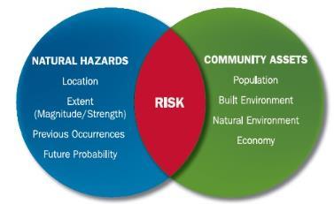
9 Hazard Identification and Risk Assessment Based on Currently Profiled Risks Any Newly Identified Risks Prevalent Hazards Previous Occurrences Probability of Future Events Assets Inventory Essential Facilities Hazard Impact Future Development Future Hazard Impacts Zoning and Land Use Hazard Profiles
10 Hazard Identification and Risk Assessment Drought Earthquakes *Discounted Extreme Heat Flooding Thunderstorms Lightning High Winds Hailstorms Tornadoes Tropical Cyclones Wildfires Winter Storms Dam/Levee Failure These natural hazards were selected based on an assessment of the overall impact (geographic extent, magnitude, probability, and exacerbating or mitigating conditions) affecting Bossier Parish.
11 Risk Assessment: Hazard Identification The plan includes descriptions of the natural hazards that affect the jurisdictions in the planning area. A hazards identification should include the following: locations affected the extent or strength previous occurrences probability of future events
12 Risk Assessment: Analyze Risk and Summarize Vulnerability Risk analysis involves evaluating vulnerable assets, describing potential impacts, and estimating losses for each hazard. This helps the community understand the greatest risks facing the area. Methods can include exposure risk analysis, historical analysis and scenario analysis. Through the risk analysis the community should be able to verbalize or create problem statements about the identified risks.

13 Risk Assessment: Maps

14 Land Use in Bossier Parish

15 Critical Facilities Government Buildings

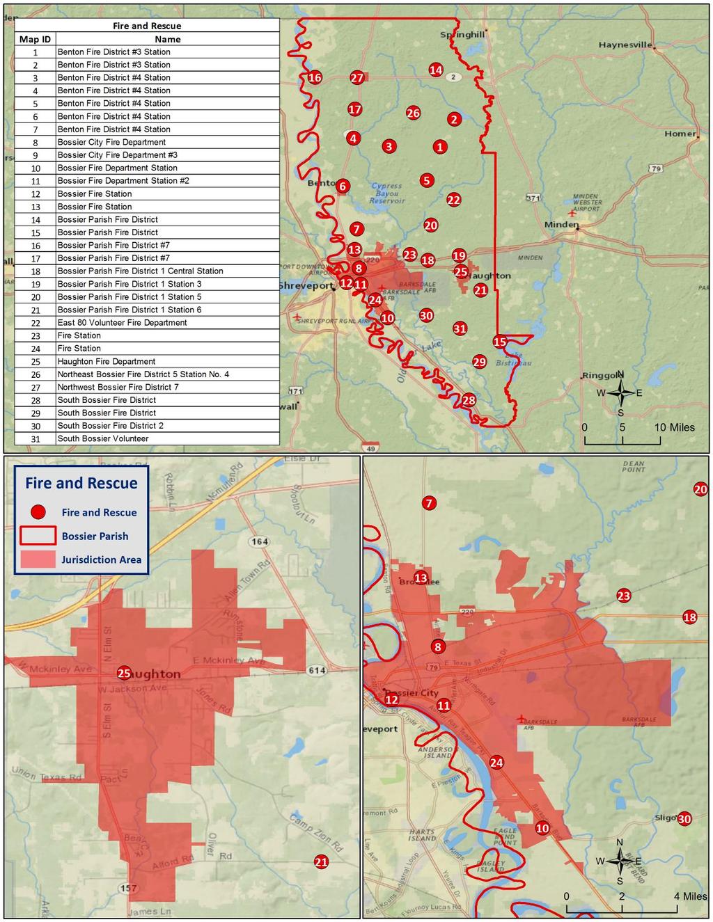
16 Critical Facilities Fire Stations

17 Critical Facilities Law Enforcement

18 Critical Facilities Public Health

19 Critical Facilities Schools
20 Drought Drought is when a region receives below-average precipitation, resulting in prolonged shortages in its water supply, whether atmospheric, surface or ground water. Drought can last for months or years, or may be declared after as few as 15 days. It can have a substantial impact on the ecosystem and agriculture of the affected region. Periods of heat can significantly worsen drought conditions.
21
22 Flooding A flood is the overflow of water onto land that is usually not inundated. The National Flood Insurance Program defines a flood as a general and temporary condition of partial or complete inundation of two or more acres of normally dry land area or of two or more properties from overflow of inland or tidal waves, unusual and rapid accumulation or runoff of surface waters from any source, mudflow, or collapse or subsidence of land along the shore of a lake or similar body of water as a result of erosion or undermining caused by waves or currents of water exceeding anticipated cyclical levels that result in a flood as defined above.

23 Flooding Types of flooding may include the following: Riverine Flash Ponding Backwater Urban Coastal

24 Flood Zone Classifications Parish/Jurisdictions


25 Flood Zone Classifications Town of Benton City of Bossier City


26 Flood Zone Classifications Town of Haughton Town of Plain Dealing

27 Flooding Elevation Model
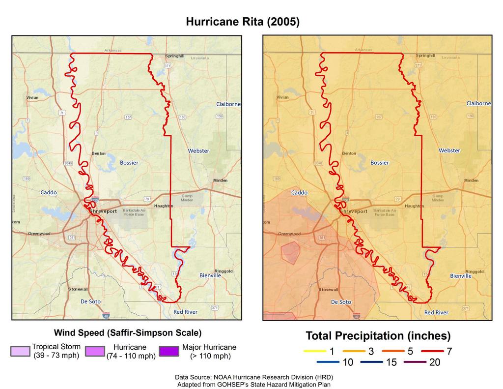
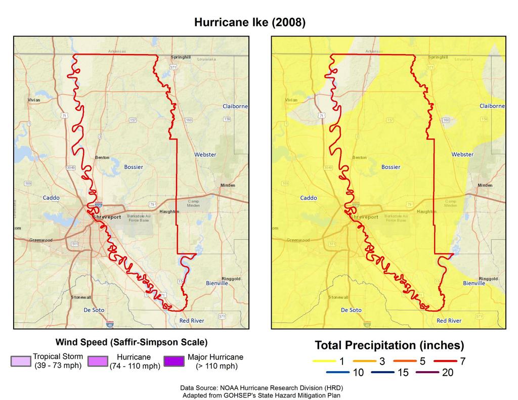
28 Repetitive Flooding Some areas flood more often than other properties, even more than those in the mapped 100-year floodplain. FEMA defines a repetitive loss property as one which has received two flood insurance claim payments for at least $1,000 over any 10-year period since These properties are important to the National Flood Insurance Program and the Community Rating System because even though they comprise 1% of the policy base, they account for 30% of the country s flood insurance claim payments.

29 Repetitive Loss Properties

30 Repetitive Loss Properties Density Model
31 Thunderstorms Lightning/High Wind/Hail A thunderstorm, also known as an electrical storm, a lightning storm, or a thundershower, is a type of storm characterized by the presence of lightning and its acoustic effect on the Earth s atmosphere known as thunder. They are usually accompanied by strong winds, heavy rain, and sometimes snow, sleet, or hail. Thunderstorms may line up in a series or rainband, known as a squall line. Strong or severe thunderstorms may rotate, known as supercells. While most thunderstorms move with the mean wind flow through the layer of the troposphere that they occupy, vertical wind sheer causes a deviation in their course at a right angle to the wind shear direction.

32 Lightning Density Model

33 Hail Density Models


34 Tornadoes Tornadoes (also called twisters and cyclones) are rapidly rotating funnels of wind extending between storm clouds and the ground. Tornadoes are the most severe storms for their size, and 70% of the world s reported tornadoes occur within the continental United States.

35 Tornado Density

36 Manufactured Home Density


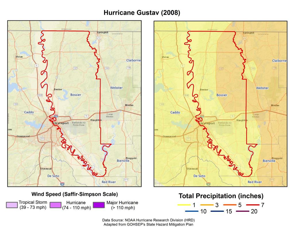
37 Tropical Cyclones Tropical cyclones are defined spinning, low-pressure air masses that draw surface air into their centers and attain strength ranging from weak tropical waves to the most intense hurricanes
38
39
40

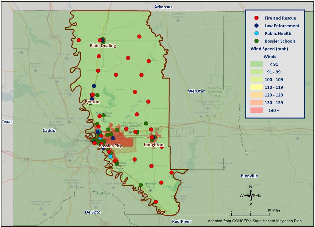
41 Critical Facilities Wind Speeds


42 Wildfires Wildfires are fueled by naturally occurring or non-native species of trees, brush, and grasses. Topography, fuel, and weather are the three principal factors that impact wildfire hazards and behavior. There are four categories of wildfires; wildland fires, interface or intermixed fires, firestorms, and prescribed natural fires. Haze in Baton Rouge from 2013 Tangipahoa/St Tammany Wildfires

43 Areas of Wildland Urban Interaction

44 Winter Weather For Louisiana and other parts of the southeastern United States, a severe winter storm occurs when humid air from the Gulf of Mexico meets a cold air mass from the north. As the temperature falls once the cold air mass crosses Louisiana, precipitation may fall in the form of snow or sleet. If the ground temperature is cold enough but air temperature is above freezing, rain can freeze instantly on contact with the surface, causing massive ice storms. Ice storms Freezes Snow events Strong winds Wind-driven snow, drifting, wind chill

45 Mitigation Strategy Parish Goals Goal 1: Enhance and develop emergency services, including response Goal 2: Protect lives and property from the dangers of natural hazards
46 Parish HM Project Status Director s Comments
47 Public Outreach Activities Risk Analysis Activity (Hazard Occurrences) Problem Area Identification (Parish Maps) Survey
48 Contact Us Brant Mitchell, SDMI Director of Research & Operations (225) Lauren Stevens, HM Project Lead (225) Chris Rippetoe, HM Project Lead Stephenson Disaster Management Institute
49 49
West Carroll Parish Hazard Mitigation Plan Update Public Meeting. August 25, 2015 Oak Grove, LA
 West Carroll Parish Hazard Mitigation Plan Update Public Meeting August 25, 2015 Oak Grove, LA Agenda Hazard Mitigation Planning Process SDMI Staff Risk Assessment SDMI Staff Update on Previous/Current
West Baton Rouge Parish Hazard Mitigation Plan Update Public Meeting. September 9, 2015 Port Allen, LA
 West Baton Rouge Parish Hazard Mitigation Plan Update Public Meeting September 9, 2015 Port Allen, LA Agenda Hazard Mitigation Planning Process SDMI Staff Risk Assessment SDMI Staff Update on Previous/Current
Assumption Parish Hazard Mitigation Plan Update Public Meeting. September 1, 2015 Napoleonville, LA
 Assumption Parish Hazard Mitigation Plan Update Public Meeting September 1, 2015 Napoleonville, LA Agenda Hazard Mitigation Planning Process SDMI Staff Risk Assessment SDMI Staff Update on Previous/Current
5.2. IDENTIFICATION OF NATURAL HAZARDS OF CONCERN
 5.2. IDENTIFICATION OF NATURAL HAZARDS OF CONCERN To provide a strong foundation for mitigation strategies considered in Sections 6 and 9, County considered a full range of natural hazards that could impact
5.2 IDENTIFICATION OF HAZARDS OF CONCERN
 5.2 IDENTIFICATION OF HAZARDS OF CONCERN 2016 HMP Update Changes The 2011 HMP hazard identification was presented in Section 3. For the 2016 HMP update, the hazard identification is presented in subsection
IDENTIFICATION OF HAZARDS OF CONCERN
 IDENTIFICATION OF HAZARDS OF CONCERN To provide a strong foundation for mitigation strategies considered in Section 6, the Village considered a full range of hazards that could impact the area and then
5.2 IDENTIFICATION OF HAZARDS OF CONCERN
 5.2 IDENTIFICATION OF HAZARDS OF CONCERN 2016 HMP Update Changes The 2011 HMP hazard identification was presented in Section 3. For the 2016 HMP update, the hazard identification is presented in subsection
5.2 IDENTIFICATION OF HAZARDS OF CONCERN
 5.2 IDENTIFICATION OF HAZARDS OF CONCERN 2015 HMP Update Changes The 2010 HMP hazard identification was presented in Section 6. For the 2015 HMP update, the hazard identification is presented in subsection
Baldwin County, Alabama
 2015 Baldwin County, Alabama Multi-Hazard Mitigation Plan I. Comprehensive Plan A multi-jurisdiction plan City of Bay Minette City of Daphne Town of Elberta City of Fairhope City of Foley City of Gulf
5.2 IDENTIFICATION OF NATURAL HAZARDS OF CONCERN
 5.2 IDENTIFICATION OF NATURAL HAZARDS OF CONCERN To provide a strong foundation for mitigation strategies considered in Sections 6 and 9, County considered a full range of natural s that could impact area,
Wind Events. Flooding Events. T-Storm Events. Awareness Alerts / Potential Alerts / Action Alerts / Immediate Action Alerts / Emergency Alerts.
 Information Updated: February of 2016 Our Alert Terms Definitions * Use exactly as seen below * Wind Events Awareness Alert - Strong Winds Potential Alert - Damaging Winds ACTION Alert - Damaging Winds
RISK ASSESSMENT COMMUNITY PROFILE NATURAL HAZARDS COMMUNITY RISK PROFILES. Page 13 of 524
 RISK ASSESSMENT COMMUNITY PROFILE NATURAL HAZARDS COMMUNITY RISK PROFILES Page 13 of 524 Introduction The Risk Assessment identifies and characterizes Tillamook County s natural hazards and describes how
On Page 1, following Paragraph 2 of the Planning Participants subsection, insert the following: 2012 Committee members included:
 Appendix 4: City of West Linn Addendum to the Clackamas County Natural Hazards Mitigation Plan 2012 Amendments and Update The Oregon Partnership for Disaster Resilience prepared this Appendix to the City
2014 Russell County Hazard Mitigation Plan Update STAKEHOLDERS AND TECHNICAL ADVISORS MEETING 2/6/14
 2014 Russell County Hazard Mitigation Plan Update STAKEHOLDERS AND TECHNICAL ADVISORS MEETING 2/6/14 Welcome and Introductions We cannot direct the wind, but we can adjust our sails. 44 CFR 201.6; Local
Table G - 6. Mitigation Actions Identified for Implementation by the City of Kent ( ) (From Wilkin County Master Mitigation Action Chart)
 (From Wilkin County Master Mitigation Action Chart)") Table G - 6. Actions Identified by the () (From Master Action Chart) Multi-Hazard Plan, 2017 Action Comments 5 All-Hazards Local Planning & Regulations Update the Operations Plan on an annual basis. Work
Table G - 6. Actions Identified by the () (From Master Action Chart) Multi-Hazard Plan, 2017 Action Comments 5 All-Hazards Local Planning & Regulations Update the Operations Plan on an annual basis. Work
2014 Annual Mitigation Plan Review Meeting
 2014 Annual Mitigation Plan Review Meeting Highland County EMA MEETING OBJECTIVES Understand Your Natural Disaster Risk Review of Previous Plans Current Plan Status Future Activity Plan/Needs of Each Community
Joseph E. Boxhorn, Ph.D., Senior Planner Southeastern Wisconsin Regional Planning Commission #
 Joseph E. Boxhorn, Ph.D., Senior Planner Southeastern Wisconsin Regional Planning Commission # 228395 Chapter I Introduction and Background Chapter II Basic Study Area Inventory and Analysis Hazard
4.1 Hazard Identification: Natural Hazards
 data is provided in an annex, it should be assumed that the risk and potential impacts to the affected jurisdiction are similar to those described here for the entire Sacramento County Planning Area. This
Severe Weather Watches, Advisories & Warnings
 Severe Weather Watches, Advisories & Warnings Tornado Watch Issued by the Storm Prediction Center when conditions are favorable for the development of severe thunderstorms and tornadoes over a larger-scale
Storm and Storm Systems Related Vocabulary and Definitions. Magnitudes are measured differently for different hazard types:
 Storm and Storm Systems Related Vocabulary and Definitions Magnitude: this is an indication of the scale of an event, often synonymous with intensity or size. In natural systems, magnitude is also related
STEUBEN COUNTY, NEW YORK. Hazard Analysis Report
 STEUBEN COUNTY, NEW YORK Hazard Analysis Report Prepared by: April 1, 2014 Background On April 1, 2014 the Steuben County Office of Emergency Management conducted a hazard analysis using the automated
They include earthquakes, volcanic eruptions, floods, landslides, and other processes and occurrences. They are included in the broader concept of.
 They include earthquakes, volcanic eruptions, floods, landslides, and other processes and occurrences. They are included in the broader concept of. In general, natural processes are labeled hazardous only
5.2 IDENTIFICATION OF HAZARDS OF CONCERN
 5.2 IDENTIFICATION OF HAZARDS OF CONCERN To provide a strong foundation for mitigation actions considered in Sections 6 and 9, County focused on considering a full range of s that could impact area, and
3.1: Identifying Hazards. Introduction
 3.1: Identifying Hazards 44 CFR 201.4(c)(5)(i)(ii) The State mitigation strategy shall include the following elements: A Plan Maintenance Process that includes: An established method and schedule for monitoring,
CITY OF TUSCALOOSA ORGANIZATION OF 2015 FMP FLOODPLAIN MANAGEMENT PLAN
 CITY OF TUSCALOOSA FLOODPLAIN MANAGEMENT PLAN FMPC Meeting #2 July 8, 2015 ORGANIZATION OF 2015 FMP 2015 Floodplain Management Plan Structure Chapter 1 Introduction Chapter 2 Community Profile Chapter
Joseph E. Boxhorn, Ph.D., Senior Planner Southeastern Wisconsin Regional Planning Commission #
 Joseph E. Boxhorn, Ph.D., Senior Planner Southeastern Wisconsin Regional Planning Commission # 228346 Chapter I Introduction and Background Chapter II Basic Study Area Inventory and Analysis Hazard
Multiple Choice Identify the choice that best completes the statement or answers the question.
 CH.15 practice TEST Multiple Choice Identify the choice that best completes the statement or answers the question. 1) The short-term state of the atmosphere is called a) climate. c) water cycle. b) weather.
REGIONAL HAZARD MITIGATION PLANNING IN SOUTH CENTRAL CONNECTICUT. Association of State Floodplain Managers Conference June 13, 2013 Hartford, CT
 REGIONAL HAZARD MITIGATION PLANNING IN SOUTH CENTRAL CONNECTICUT Association of State Floodplain Managers Conference June 13, 2013 Hartford, CT MULTI-JURISDICTION MITIGATION PLAN South Central Regional
WINTER STORM Annex II
 WINTER STORM Annex II I. PURPOSE A. This annex has been prepared to ensure a coordinated response by state agencies to requests from local jurisdictions to reduce potential loss of life and to ensure essential
HAZARD IDENTIFICATION... 1 HAZARD EFFECTS OF CLIMATE CHANGE... 2 OVERVIEW OF HAZARD ANALYSIS... 4 BUILDING VALUES... 5 POTENTIAL DOLLAR LOSSES...
 R ISK OVERVIEW IDENTIFICATION... 1 EFFECTS OF CLIMATE CHANGE... 2 OVERVIEW OF ANALYSIS... 4 BUILDING VALUES... 5 POTENTIAL DOLLAR LOSSES... 7 IDENTIFICATION This section begins the risk assessment, which
KENTUCKY HAZARD MITIGATION PLAN RISK ASSESSMENT
 KENTUCKY HAZARD MITIGATION PLAN RISK ASSESSMENT Presentation Outline Development of the 2013 State Hazard Mitigation Plan Risk Assessment Determining risk assessment scale Census Data Aggregation Levels
Advisory Committee Meeting December 5, 2012
 SOUTH CENTRAL REGION MULTI-JURISDICTION HAZARD MITIGATION PLAN Advisory Committee Meeting December 5, 2012 MEETING PURPOSE Review Municipality Meetings and Capabilities Review Hazard Identification and
Oregon APA Legal Issues Workshop December 7, Tricia Sears, DLCD With information from Bill Burns, DOGAMI
 Oregon APA Legal Issues Workshop December 7, 2018 Tricia Sears, DLCD With information from Bill Burns, DOGAMI How this Topic Arrived WE FREQUENTLY HEAR CONCERNS ABOUT LIABILITY AND TAKINGS. Current federal
B.2 Sources for Hazard Identification, Profiling, and Ranking (Section 3) Overview of Sussex County s History of Hazards
 Overview of Sussex County s History of Hazards") Appendix B Sources B.1 Sources for Planning Process (Section 2) FEMA. Mitigation Planning Guidance (386 Series). Available on the web at: http://www.fema.gov/plan/mitplanning/planning_resources.shtm FEMA
Appendix B Sources B.1 Sources for Planning Process (Section 2) FEMA. Mitigation Planning Guidance (386 Series). Available on the web at: http://www.fema.gov/plan/mitplanning/planning_resources.shtm FEMA
Key Concept Weather results from the movement of air masses that differ in temperature and humidity.
 Section 2 Fronts and Weather Key Concept Weather results from the movement of air masses that differ in temperature and humidity. What You Will Learn Differences in pressure, temperature, air movement,
A GEOGRAPHIC ASSESSMENT OF MAJOR DISASTER DECLARATIONS ACROSS THE LOWER 48 STATES
 A GEOGRAPHIC ASSESSMENT OF MAJOR DISASTER DECLARATIONS ACROSS THE LOWER 48 STATES A summary report produced by the Southern Climate Impacts Planning Program (SCIPP) Author: James Hocker Southern Climate
Pre-Disaster Natural Hazard Mitigation Plan Guilford, Connecticut History of Hazard Mitigation Planning Authority Disaster Mitigation Act of 2000 (ame
 Pre-Disaster Natural Hazard Mitigation Plan Guilford, Connecticut History of Hazard Mitigation Planning Authority Disaster Mitigation Act of 2000 (amendments to Stafford Act of 1988) Presented by: David
Assessing Hazards and Risk
 Page 1 of 6 EENS 204 Tulane University Natural Disasters Prof. Stephen A. Nelson Assessing Hazards and Risk This page last updated on 07-Jan-2004 As discussed before, natural disasters are produced by
Running Head: HAZARD MITIGATION PLAN OUTLINE FOR MISSISSIPPI 1
 Running Head: HAZARD MITIGATION PLAN OUTLINE FOR MISSISSIPPI 1 Hazard Mitigation Plan Outline for Mississippi Name: Institution: HAZARD MITIGATION PLAN OUTLINE FOR MISSISSIPPI 2 Hazard Mitigation Plan
Extreme Weather and Risks to Infrastructure. Heather Auld & Neil Comer Risk Sciences International
 Extreme Weather and Risks to Infrastructure Heather Auld & Neil Comer Risk Sciences International The Science is Valid and the Evidence grows Stronger AGREE Climate Change Disagree More Intense Rainfall
Chippewa County Natural Hazards Mitigation Plan
 2014 Chippewa County Natural Hazards Mitigation Plan Prepared for: Chippewa County Office of Emergency Management With the Assistance of: Eastern U.P. Regional Planning & Development Commission April,
Comparative Analysis of Hurricane Vulnerability in New Orleans and Baton Rouge. Dr. Marc Levitan LSU Hurricane Center. April 2003
 Comparative Analysis of Hurricane Vulnerability in New Orleans and Baton Rouge Dr. Marc Levitan LSU Hurricane Center April 2003 In order to compare hurricane vulnerability of facilities located in different
Catastrophic Events Impact on Ecosystems
 Catastrophic Events Impact on Ecosystems Hurricanes Hurricanes An intense, rotating oceanic weather system with sustained winds of at least 74 mph and a welldefined eye Conditions for formation: Warm water
Understanding Weather and Climate Risk. Matthew Perry Sharing an Uncertain World Conference The Geological Society, 13 July 2017
 Understanding Weather and Climate Risk Matthew Perry Sharing an Uncertain World Conference The Geological Society, 13 July 2017 What is risk in a weather and climate context? Hazard: something with the
Daily Operations Briefing. Tuesday, January 9, :30 a.m. EST
 Daily Operations Briefing Tuesday, January 9, 2018 8:30 a.m. EST Significant Activity Jan 8-9 Significant Events: Flash Flooding CA Tropical Activity: None Significant Weather: Heavy rain and Thunderstorms
Earthquakes. & Expansive Soils
 Earthquakes & Expansive Soils January 22, 2009 Plan Update Flanagan & Associates, LLC Consultants Tulsa, OK www.rdflanagan.com rdflanagan@rdflanagan.com Plan can be reviewed at: www.rdflanagan.com/.html
Miami-Dade County Overview
 Miami-Dade County Overview 2,000 square miles World s busiest cruise port 2.6 million residents Second busiest US airport for international travelers Gateway to the Caribbean and Latin America Natural
HAZARD DESCRIPTION... 1 LOCATION... 1 EXTENT... 1 HISTORICAL OCCURRENCES...
 WINTER STORM HAZARD DESCRIPTION... 1 LOCATION... 1 EXTENT... 1 HISTORICAL OCCURRENCES... 3 SIGNIFICANT PAST EVENTS... 4 PROBABILITY OF FUTURE EVENTS... 5 VULNERABILITY AND IMPACT... 5 Hazard Description
SECTION 6 VULNERABILITY ASSESSMENT
 SECTION 6 VULNERABILITY ASSESSMENT This section identifies and quantifies the vulnerability of the MEMA District 1 Region to the significant hazards identified in the previous sections (Hazard Identification
Guided Notes Weather. Part 2: Meteorology Air Masses Fronts Weather Maps Storms Storm Preparation
 Guided Notes Weather Part 2: Meteorology Air Masses Fronts Weather Maps Storms Storm Preparation The map below shows North America and its surrounding bodies of water. Country borders are shown. On the
NOAA s National Weather Service. National Weather Service
 NOAA s National Weather Service Serving the Nation s Environmental Forecasting Needs Lynn Maximuk Regional Director National Weather Service Central Region Headquarters Kansas City, Missouri America s
MODELLING FROST RISK IN APPLE TREE, IRAN. Mohammad Rahimi
 WMO Regional Seminar on strategic Capacity Development of National Meteorological and Hydrological Services in RA II (Opportunity and Challenges in 21th century) Tashkent, Uzbekistan, 3-4 December 2008
CLIMATE CHANGE ADAPTATION BY MEANS OF PUBLIC PRIVATE PARTNERSHIP TO ESTABLISH EARLY WARNING SYSTEM
 CLIMATE CHANGE ADAPTATION BY MEANS OF PUBLIC PRIVATE PARTNERSHIP TO ESTABLISH EARLY WARNING SYSTEM By: Dr Mamadou Lamine BAH, National Director Direction Nationale de la Meteorologie (DNM), Guinea President,
Thunderstorm. Thunderstorms result from the rapid upward movement of warm, moist air.
 Severe Weather Thunderstorm A thunderstorm (aka an electrical storm, a lightning storm, or a thundershower) is a type of storm characterized by the presence of lightning and its acoustic effect, thunder.
WHAT HAPPENS WHEN A TORNADO STRIKES THE COMMUNITY? Carroll County Sheriff s Office Emergency Management
 WHAT HAPPENS WHEN A TORNADO STRIKES THE COMMUNITY? Carroll County Sheriff s Office Emergency Management WHAT IS EMERGENCY MANAGEMENT? Carroll County Sheriff s Office Emergency Management Agency is responsible
APPENDIX D: Hazard Summary Matrices
 APPENDIX D: Hazard Summary Matrices Florida Division of Emergency Management Appendix D: HAZARD SUMMARY MATRICES : A few sentences from the hazard description. Frequency: Ranking of how often the hazard
A bright flash that is produced due to electrical discharge and occurs during a thunderstorm.
 Science Mr. G/Mrs. Kelly Name: KEY Date: Inv.6.1 - That s a Fact: An Introduction to Thunderstorms, Tornadoes, and Hurricanes (pgs.92-97) 1. Define lightning. A bright flash that is produced due to electrical
Meteorology. Chapter 10 Worksheet 2
 Chapter 10 Worksheet 2 Meteorology Name: Circle the letter that corresponds to the correct answer 1) Downdrafts totally dominate the in the development of a thunderstorm. a) dissipating stage b) mature
United States Multi-Hazard Early Warning System
 United States Multi-Hazard Early Warning System Saving Lives Through Partnership Lynn Maximuk National Weather Service Director, Central Region Kansas City, Missouri America s s Weather Enterprise: Protecting
Jim Fox. copyright UNC Asheville's NEMAC
 Decisions and System Thinking Jim Fox November, 2012 1 UNC Asheville s s NEMAC National Environmental Modeling and Analysis Center Applied Research and technology development on integration of environmental
SPEARFISH FIRE DEPARTMENT POLICIES AND PROCEDURES
 SPEARFISH FIRE DEPARTMENT POLICIES AND PROCEDURES Page 1 of 5 Volume: Operation Section: 20.00 Number: 20.09 Subject: Weather Watches, Warnings, Advisory s and Spotter Activation Date Issued: 28 March
Kentucky Weather Hazards: What is Your Risk?
 Kentucky Weather Hazards: What is Your Risk? Stuart A. Foster State Climatologist for Kentucky 2010 Kentucky Weather Conference Bowling Green, Kentucky January 16, 2010 Perspectives on Kentucky s Climate
4.4 Assessing Vulnerability: Estimating Potential Losses
 4.4 Assessing Vulnerability: Estimating Potential Losses This section presents exposure, damage, and loss estimates, for each of the 8 hazards evaluated. The findings support planning efforts based on
Daily Operations Briefing Wednesday, April 5, :30 a.m. EDT
 Daily Operations Briefing Wednesday, April 5, 2017 8:30 a.m. EDT Significant Activity Apr 4-5 Significant Events: Severe Weather Southern Plains to Southeast Significant Weather: Severe thunderstorms &
Weather Unit Part 2: Meteorology
 Name: Earth Science Date: Period: Weather Unit Part 2: Meteorology 1 The map below shows North America and its surrounding bodies of water. Country borders are shown. On the map, label the following locations:
Daily Operations Briefing. Wednesday, August 23, :30 a.m. EDT
 Daily Operations Briefing Wednesday, August 23, 2017 8:30 a.m. EDT Significant Activity August 22-23 Significant Events: Tropical Weather Threat Gulf Coast Tropical Activity: Atlantic Disturbance 1 High
Workshop on Drought and Extreme Temperatures: Preparedness and Management for Sustainable Agriculture, Forestry and Fishery
 Workshop on Drought and Extreme Temperatures: Preparedness and Management for Sustainable Agriculture, Forestry and Fishery 16-17 Feb.2009, Beijing, China Modeling Apple Tree Bud burst time and frost risk
Wednesday, June 13, :30 a.m. EDT
 Wednesday, June 13, 2018 8:30 a.m. EDT Significant Activity June 12-13 Significant Events: None Tropical Activity: Atlantic Disturbance 1: Low (20%) Eastern Pacific Tropical Storm Bud; Disturbance 1: Low
Daily Operations Briefing. Friday, October 6, :30 a.m. EDT
 Daily Operations Briefing Friday, October 6, 2017 8:30 a.m. EDT Significant Activity Oct 5-6 Significant Events: Response for Hurricane Maria, Preparations for Tropical Storm Nate Tropical Activity: Atlantic
Daily Operations Briefing. Tuesday, June 27, :30 a.m. EDT
 Daily Operations Briefing Tuesday, June 27, 2017 8:30 a.m. EDT Significant Activity June 26-27 Significant Events: None Tropical Activity: Atlantic Disturbance 1: Low (near 0%) Eastern Pacific Hurricane
Timeframe. Crow Wing County, Baxter, Brainerd, Breezy Point, Crosby, Crosslake, Cuyuna, Deerwood, Emily, Fifty
 Table G - 13. s Identified for by the () (From Crow Wing County Master Chart) 1 5 9 All- Hazards All- Hazards Winter Work to ensure that all Crow Wing County residents are aware of and sign-up for the
Daily Operations Briefing Wednesday, February 8, :30 a.m. EST
 Daily Operations Briefing Wednesday, February 8, 2017 8:30 a.m. EST Significant Activity Feb 7-8 Significant Events: Severe weather/tornadoes - Louisiana Significant Weather: Freezing rain possible Pacific
Daily Operations Briefing. Monday, October 9, :30 a.m. EDT
 Daily Operations Briefing Monday, October 9, 2017 8:30 a.m. EDT Significant Activity Oct 8-9 Significant Events: Response for Hurricane Maria Tropical Activity: Atlantic Tropical Depression Seventeen Eastern
NOAA S2S Planning. Dave DeWitt Fred Toepfer
 NOAA S2S Planning Dave DeWitt Fred Toepfer 1 Agenda 1. Brief synopsis of The Weather Research and Forecasting Act of 2017 2. Report to Congress a. Timeline b. Process c. Document Outline 3. Some Preliminary
The AIR Bushfire Model for Australia
 The AIR Bushfire Model for Australia In February 2009, amid tripledigit temperatures and drought conditions, fires broke out just north of Melbourne, Australia. Propelled by high winds, as many as 400
Daily Operations Briefing Tuesday, April 4, :30 a.m. EDT
 Daily Operations Briefing Tuesday, April 4, 2017 8:30 a.m. EDT Significant Activity Apr 3-4 Significant Events: Severe Weather Southern Plains to Southeast Significant Weather: Severe Thunderstorms and
This section identifies and profiles the hazards that could affect the state of Alaska.
 5. This section identifies and profiles the hazards that could affect the state of Alaska. 5.1. OVERVIEW A hazard analysis includes identifying, screening, and profiling each hazard. Hazard identification
Poverty and Hazard Linkages
 Poverty and Hazard Linkages Global Risk Identification Programme Proposal Development Coordination Meeting Friday, 19 May 2006 CIESIN Earth Institute Columbia University www.ciesin.columbia.edu Data Improvements
Hazard Vulnerability Analysis Union County
 Hazard Vulnerability Analysis Union County Union County Geographic Description Union County is located in northeastern Oregon and bordered by Baker and Grant County to the south, Wallowa County to the
CLIMATE READY BOSTON. Climate Projections Consensus ADAPTED FROM THE BOSTON RESEARCH ADVISORY GROUP REPORT MAY 2016
 CLIMATE READY BOSTON Sasaki Steering Committee Meeting, March 28 nd, 2016 Climate Projections Consensus ADAPTED FROM THE BOSTON RESEARCH ADVISORY GROUP REPORT MAY 2016 WHAT S IN STORE FOR BOSTON S CLIMATE?
Daily Operations Briefing Monday, February 13, :30 a.m. EST
 Daily Operations Briefing Monday, February 13, 2017 8:30 a.m. EST Significant Activity Feb 10-13 Significant Events: Oroville Dam Spillway Erosion CA Significant Weather: Heavy Snow Southwest to Southern
National Wildland Significant Fire Potential Outlook
 National Wildland Significant Fire Potential Outlook National Interagency Fire Center Predictive Services Issued: September, 2007 Wildland Fire Outlook September through December 2007 Significant fire
Daily Operations Briefing. Tuesday, March 27, :30 a.m. EDT
 Daily Operations Briefing Tuesday, March 27, 2018 8:30 a.m. EDT Significant Activity Mar 26-27 Significant Events: None Tropical Activity: Western Pacific No activity affecting U.S. interests Significant
Page G Crow Wing County Multi-Hazard Mitigation Plan, 2017
 Table G - 10. s Identified by the () (From Crow Wing County Master Chart) 1 5 All- Hazards All- Hazards Work to ensure that all Crow Wing County residents are aware of and sign-up for the County s Emergency
CHAPTER 4 NATURAL HAZARDS RISK ASSESSMENT
 CHAPTER 4 NATURAL HAZARDS RISK ASSESSMENT Requirement 201.6(c)(2): [The plan shall include] A risk assessment that provides the factual basis for activities proposed in the strategy to reduce losses from
Guided Reading Chapter 18: Weather Patterns
 Name Number Date Guided Reading Chapter 18: Weather Patterns 18-1: Air Masses and Fronts 1. What is an air mass? 2. Scientists classify air masses according to and 3. Is the following sentence true or
Comprehensive Emergency Management Plan
 Comprehensive Emergency Management Plan Section 6- Severe Weather/Wildfire Annex Blank Intentionally 2 CEMP Annex 6 11 Severe Weather / Wildfire Annex I. PURPOSE This plan outlines the procedures to be
Air Masses, Fronts & Storms
 Air Masses, Fronts & Storms Air Masses and Fronts Bell Work Define Terms (page 130-135) Vocab Word Definition Picture Air Mass A huge body of air that has smilier temperature, humidity and air pressure
Title: Concepts of Flood Risk
 Title: Concepts of Flood Risk Title Prepared by: Dr. Mohammed Abdulkadir and Dr. Micha Werner Outline of presentation Hazards Flood Event Flood losses Classification of floods Flood management Concepts
Natural Disasters. in Florida. Severe Thunderstorms
 Natural Disasters in Florida SC.6.E.7.7 Investigate how natural disasters have affected human life in Florida. Severe Thunderstorms While the typical afternoon thunderstorm in Florida may not appear to
Saturday, June 9, :30 a.m. EDT
 Saturday, June 9, 2018 8:30 a.m. EDT Significant Activity June 8-9 Significant Events: None Tropical Activity: Atlantic No tropical cyclones expected next 48 hours Eastern Pacific Hurricane Aletta; Disturbance
History of Natural and Man-Made Disaster within the Region. There have been two aircraft accident resulting in casualties within the past 50 years.
 Aircraft Accidents Hail History of Natural and Man-Made Disaster within the Region There have been two aircraft accident resulting in casualties within the past 50 years. Date Number of Passengers Number
Untitled.notebook May 12, Thunderstorms. Moisture is needed to form clouds and precipitation the lifting of air, or uplift, must be very strong
 Thunderstorms Moisture is needed to form clouds and precipitation the lifting of air, or uplift, must be very strong cold air and warm air must mix; creating an active circulation system that has both
Unit 2: The World in Spatial Terms (Lessons 6-7)
") Unit 2: The World in Spatial Terms (Lessons 6-7) Physical Features of Earth Create Challenges and Opportunities The physical features of Earth create both challenges and opportunities for the people living
Unit 2: The World in Spatial Terms (Lessons 6-7) Physical Features of Earth Create Challenges and Opportunities The physical features of Earth create both challenges and opportunities for the people living
Saturday, April 14, :30 a.m. EDT
 Saturday, April 14, 2018 8:30 a.m. EDT Significant Activity April 13-14 Significant Events: Severe Weather Southern/Central Plains and Lower/Middle Mississippi Valley Tropical Activity: Western Pacific
Daily Operations Briefing Saturday, January 16, :30 a.m. EST
 Daily Operations Briefing Saturday, January 16, 2016 8:30 a.m. EST Significant Activity: Jan 15-16 Significant Events: None Significant Weather: Flooding Central and Southern US Nor'easter expected over
Best Practices Natural Disasters Action Plan
 Best Practices Natural Disasters Action Plan MODERATORS: Jeannie Chiaromonte, CAR Vice President / National Remarketing Manager Bank of America Chuck Novince, CAR Vice President National Accounts Manheim
Chapter 3: Weather Fronts & Storms
 Chapter 3: Weather Fronts & Storms An AIR MASS is a large body of air that has similar characteristics (temperature, humidity) throughout. Air masses can be massively large. Air masses are classified by
Weather Systems III: Thunderstorms and Twisters
 Weather Systems III: Thunderstorms and Twisters Review 1. Definition of airmasses? Bergeron classification of air masses 2. Surface weather analysis: Station model, wind speed code, present weather 3.
Mr. P s Science Test!
 WEATHER- 2017 Mr. P s Science Test! # Name Date 1. Draw and label a weather station model. (10 pts) 2. The is the layer of the atmosphere with our weather. 3. Meteorologists classify clouds in about different