The Importance of Geospatial in the Construction Industry. 10 December, 2015
|
|
|
- Harold Scot Shepherd
- 6 years ago
- Views:
Transcription

1 The Importance of Geospatial in the Construction Industry 10 December, 2015

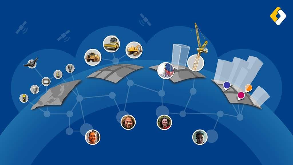
2 Transformation will drive Build Operate Reduce Total Cost of Use Increased design freedom to deliver better infrastructure Reduce waste and inefficiency
3


4 Transformation Enablers BIM Collaboration Spatial Context Connected Networks Integrated Workspace Management
5 BIM


6 Building Information Modeling - BIM 2D/3D Design Symbolic Human transcription BIM 3D - Object/Relationship Computational Association of the asset with space, cost, schedule, process, status, content and more
7 Cost Cost Object Level Representation Schedule Schedule BIM is a Connector Quantities by Location are key Data + Context = Information
8 Building Information Modeling - BIM Highlights by Asset Phase Planning Site selection and analysis Visualization Existing conditions modeling Cost estimating (5D)... Construction Digital fabrication Construction planning (4D) Constructability analysis Clash analysis Site utilization planning... Design Design authoring and analysis Energy analysis Lighting analysis Structural analysis 3D design coordination... Facilities Management Asset/space utilization/optimization Building automation, efficiency and performance Building analytics and capital planning...
9 BIM adoption Moving beyond visualization to applications that will Increase productivity, reduce cost and increase safety) 62% 72% % of contractor adoption of BIM by Phase % of where contractors believe BIM provides ROI 46% 36% 35% 19% 24% Spatial Context Matters 17% 16% 9% >4% CONCEPT ENGINEERING & DESIGN ESTIMATING PROJECT PLANNING CONSTRUCT DOCUMENT & HAND OVER Sources: (1) 2014 McGraw-Hill Smart Market Report; The Business Value of BOM for Construction in Major Global Markets, (2) Internal Trimble market estimate


10 The Smart Building: BIM
11 Spatial Context
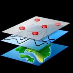
12 Spatial Context = Relation to Space Location, location, location Buffer How many things are within x distance of this location? Overlay What things are within the boundaries of a specified area? Proximity What are the nearest x things to this location? Geocoding Provide a location that corresponds to a given address. Density Show the density of things typically per square unit, such as feet or acre (meter or hectare). Route Display the fastest or shortest distance between two points along a transportation network (roads, rail, footpaths). Spatial selection Select the objects in layer A that are within the boundaries of a feature(s) in layer B. Drive time Show me all the things or areas that can be aggregated within a specified drive time of location x. Temporal Show the geographic relationship between things over time. Line of sight What can I see from location x (3D)? Source (1) Geographic information systems (GIS) for facility management Stuart Rich and Kevin H. Davis (2) Are Smart Cities Enough - Stéphane Roche, Nashid Nabian, Kristian Kloeckl, and Carlo Ratti


13 Distance Distance Spatial Context Address Address
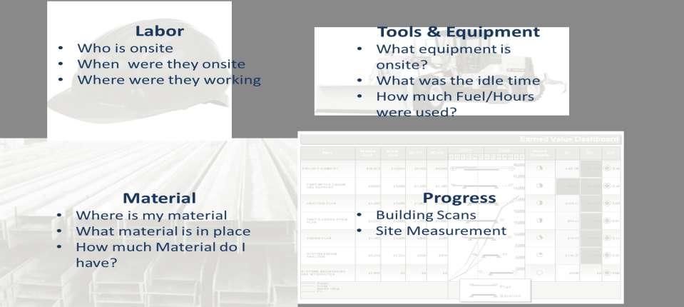
14 Spatial Context Planning Site selection and Buy vs lease Survey /Permitting Energy Analysis Spatial Planning Environmental Analysis... Design As-Built Data collection and site assessment Visualization... Construction Layout, control and Q/A Volumetric analysis Labor, Equipment & Material Tracking, Production Control, Q/A Safety/Security Supply chain management... Facilities Management Asset/space utilization/optimization Facility Management and Maintenance...

15 Google Prototype: Project Tango Android based device with location awareness

16 Google Prototype: Project Tango Android based device with location awareness

17 Microsoft HoloLens
18 Connected Networks
 Harvard Business Review; Smart, Connected")
19 Continuously Connected Network(s) Cloud Data Stores People & Physical Assets Portals & Devices Relevant Source: (1) Harvard Business Review; Smart, Connected Products

")


20 Association Material Methods Labor Locations f(x) Object Qty s (per Location) Cost & Time are fully associated with the 3D model Equipment Cost Unit Costs Crew Productivity Schedule
21 Continuously Connected
22 Continuously Connected


23 BIM + Spatial Context


24 BIM + Spatial Context + Connected
25 Integrated Workspace Management (IWMS)
26 Integrated Workspace Management Cost of Occupancy is the second largest cost to a company after payroll Individual workspaces are only US buildings consume 70% of actually occupied on average of all electricity and 50% of it is about 42% of the typical day wasted 42% 50% 2nd 17% of occupancy cost is construction, 83% of occupancy cost is rent, office services, operations & maintenance, utilities, security, housekeeping and other costs 83%


27 New Digital Workplace in the Digital City Bryant Park


28 BIM + Spatial Context + Connected + IWMS As BIM transforms the way we maintain and operate assets, Geospatial data becomes very important

29 The Edge, in Amsterdam
30 COLLABORATION
31
32
33 Wrap Up
34 Together we can transform the way the world works Enabler Building Information Modeling (BIM) Spatial Context Connected Networks Integrated Workplace Management Collaboration Value Intelligent process to capture, relate and maintain building and project information Relationships between people, places and assets Continuously Connected network of people, assets and data for automating, processing, informing, tracking, measuring, crowd sourcing Cost and behavior in a space for planning and optimization Leveraging & liberating data through standards, common language, sharing Transformation: Build Operate Total Cost of Use design freedom deliver better infrastructure waste and inefficiency
35 Together we can transform our industry
A Broad View of Geospatial Technology & Systems
 A Broad View of Geospatial Technology & Systems Pete Large Vice President, Trimble On the shoulders of giants 1 Since their time, our ability to generate geospatial information has grown exponentially
An Industry Perspective. Bryn Fosburgh Vice President Trimble
 An Industry Perspective Bryn Fosburgh Vice President Trimble Who are we? Professionals & Consultants Geospatial Professionals working at or with: AEC Consultants Transportation Departments Construction
Empowering water/wastewater network management with GIS
 Empowering water/wastewater network management with GIS Ioannis Kavouras_GIS Manager Surveying Engineer, MSc, MBA The Company responsible for fresh water distribution & sanitation serving 1.500.000 citizens
ArcGIS is Advancing. Both Contributing and Integrating many new Innovations. IoT. Smart Mapping. Smart Devices Advanced Analytics
 ArcGIS is Advancing IoT Smart Devices Advanced Analytics Smart Mapping Real-Time Faster Computing Web Services Crowdsourcing Sensor Networks Both Contributing and Integrating many new Innovations ArcGIS
You are Building Your Organization s Geographic Knowledge
 You are Building Your Organization s Geographic Knowledge And Increasingly Making it Available Sharing Data Publishing Maps and Geo-Apps Developing Collaborative Approaches Citizens Knowledge Workers Analysts
Asset Management Planning. GIS and Asset Management Integration Readiness Assessment
 Asset Management Planning GIS and Asset Management Integration Readiness Assessment With too little data, you won t be able to make any conclusions that you trust. With loads of data you will find relationships
TRAITS to put you on the map
 TRAITS to put you on the map Know what s where See the big picture Connect the dots Get it right Use where to say WOW Look around Spread the word Make it yours Finding your way Location is associated with
The Social Life of Location. David Sonnen September 2008
 The Social Life of Location David Sonnen September 2008 Three Transformations Traditional Cartography -- 2300 B.C. - ~ 1980 Maps represent location and attributes Portable, persistent communication/ reference
ArcGIS. for Server. Understanding our World
 ArcGIS for Server Understanding our World ArcGIS for Server Create, Distribute, and Manage GIS Services You can use ArcGIS for Server to create services from your mapping and geographic information system
GIS Integration to Maximo
 GIS Integration to Maximo Tuesday 15 th January 2008 Mahmoud Jaafar Systems Director GISTEC Agenda Introduction Why AMS & GIS Integration? ESRI GIS Enabling Technology. Integrating GIS & Maximo. What do
ArcGIS Enterprise: What s New. Philip Heede Shannon Kalisky Melanie Summers Sam Williamson
 ArcGIS Enterprise: What s New Philip Heede Shannon Kalisky Melanie Summers Sam Williamson ArcGIS Enterprise is the new name for ArcGIS for Server What is ArcGIS Enterprise ArcGIS Enterprise is powerful
Industry Trends and Direction: a quick look! John Whitehead Trimble Navigation Ltd.
 Industry Trends and Direction: a quick look! John Whitehead Trimble Navigation Ltd. Converging forces have placed geospatial information at the center of an evolving ecosystem Technology Societal Forces
GIS and Governing Anchorage. GIS Critical for Efficient, Transparent Government How is GIS Program Doing Where can GIS Program Take us
 GIS and Governing Anchorage GIS Critical for Efficient, Transparent Government How is GIS Program Doing Where can GIS Program Take us Municipality of Anchorage Office of Economic And Community Development
US National Spatial Data Infrastructure A Spatial Framework for Governance and Policy Development to Enable a Location-Based Digital Ecosystem
 GeoPlatform Workshop 7 Dec 2016, Department of the Interior Washington, D.C. US National Spatial Infrastructure A Spatial Framework for Governance and Policy Development to Enable a Location-Based Digital
ESRI Survey Summit August Clint Brown Director of ESRI Software Products
 ESRI Survey Summit August 2006 Clint Brown Director of ESRI Software Products Cadastral Fabric How does Cadastral fit with Survey? Surveyors process raw field observations Survey measurements define high-order
Working with ArcGIS Online
 Esri International User Conference San Diego, CA Technical Workshops July 12, 2011 Working with ArcGIS Online Bern Szukalski, Deane Kensok Topics for this Session ArcGIS Online Overview ArcGIS Online Content
Sustainability Adaptation Transparency Accountability. $400 FBC of fuel.
 Sustainability Adaptation Transparency Accountability $400 FBC of fuel. We need a sustainability platform Tools for organization, collaboration, policy, data collection, storage, analysis, understanding,
Geospatial natural disaster management
 Geospatial natural disaster management disasters happen. are you ready? Natural disasters can strike almost anywhere at any time, with no regard to a municipality s financial resources. These extraordinarily
Tools to Assess Local Health Needs. Richard Leadbeater, Esri NACo 2011 Healthy Counties Forum December 1, 2011
 Tools to Assess Local Health Needs Richard Leadbeater, Esri NACo 2011 Healthy Counties Forum December 1, 2011 Richard Leadbeater currently holds the position of Industry Solutions Manager with Esri. He
GIS-based Smart Campus System using 3D Modeling
 GIS-based Smart Campus System using 3D Modeling Smita Sengupta GISE Advance Research Lab. IIT Bombay, Powai Mumbai 400 076, India smitas@cse.iitb.ac.in Concept of Smart Campus System Overview of IITB Campus
What s New in Collector for ArcGIS (Aurora)
") What s New in Collector for ArcGIS (Aurora) Derek Law (dlaw@esri.com) Esri Apps Product Management @GIS_Bandit Oct 10 th, 2018 Agenda Product overview Use cases Preparing data for Collector for ArcGIS
What s New in Collector for ArcGIS (Aurora) Derek Law (dlaw@esri.com) Esri Apps Product Management @GIS_Bandit Oct 10 th, 2018 Agenda Product overview Use cases Preparing data for Collector for ArcGIS
Investigating the practical relationship between GIS and BIM; then relating that to a 3D cadastre. J. Gabriel van Wyk, Johan Nel
 Investigating the practical relationship between GIS and BIM; then relating that to a 3D cadastre. J. Gabriel van Wyk, Johan Nel Overview So exactly what is BIM? Available BIM offerings in the market Traditional
June 19 Huntsville, Alabama 1
 June 19 Huntsville, Alabama 1 Real-Time Geospatial Data: The Fusion of PI and ArcGIS Enabling Smarter Facilities Management OSIsoft and Esri Mapping and Location Analytics Platform Supporting Your Use
geographic patterns and processes are captured and represented using computer technologies
 Proposed Certificate in Geographic Information Science Department of Geographical and Sustainability Sciences Submitted: November 9, 2016 Geographic information systems (GIS) capture the complex spatial
Esri and GIS Education
 Esri and GIS Education Organizations Esri Users 1,200 National Government Agencies 11,500 States & Regional Agencies 30,800 Cities & Local Governments 32,000 Businesses 8,500 Utilities 12,600 NGOs 11,000
Pushing the Standards Edge: Collaborative Testbeds to Accelerate Standards Development and Implementation
 Pushing the Standards Edge: Collaborative Testbeds to Accelerate Standards Development and Implementation Mark E. Reichardt President mreichardt@opengeospatial.org 31 October 2006 2006 Open Geospatial
DATA SCIENCE SIMPLIFIED USING ARCGIS API FOR PYTHON
 DATA SCIENCE SIMPLIFIED USING ARCGIS API FOR PYTHON LEAD CONSULTANT, INFOSYS LIMITED SEZ Survey No. 41 (pt) 50 (pt), Singapore Township PO, Ghatkesar Mandal, Hyderabad, Telengana 500088 Word Limit of the
The Underutilization of GIS & How to Cure It. Adam Carnow Esri
 The Underutilization of GIS & How to Cure It Adam Carnow Esri What is GIS? A framework to organize, communicate, and understand the science of our world Business Intelligence (BI) is the set of
Google Maps and Beyond
 Google Maps and Beyond Aaron Paul First American Title apaul@firstam.com 2015 APRA Symposium Association of Professional Reserve Analysts May 2 nd, 2015 Google Maps and Beyond - Overview Business case
Introducing Spatial IQ
 Introducing Spatial IQ TM A Managed Services Approach to Enterprise GIS Let AppGeo be your bridge to the future. The Magic of Location AppGeo believes that information plus geography changes how we work
Oman NSDI Business Values and Future Directions. Hassan Alawi Alghazali Acting Director General National Spatial Data Infrastructure
 Oman NSDI Business Values and Future Directions Hassan Alawi Alghazali Acting Director General National Spatial Data Infrastructure Presentation Outline Geospatial Maturity Current Challenges NCSI s Role
GIS is a tool for Pipeline Management
 ESRI User Conference 2011 GIS is a tool for Pipeline Management Pacheco (1) (1) Position: GIS Supervisor for Compañía Operadora de LNG del Perú. Address: Jiron Villa Real de los Infantes 255 D604, La Molina.
Law Enforcement Solutions and Applications
 ArcGIS for Solutions and Applications Solutions and Applications ArcGIS for Platform ArcGIS for Collection of solutions and applications for law enforcement. Built on the ArcGIS platform. For any named
Ministry of Health and Long-Term Care Geographic Information System (GIS) Strategy An Overview of the Strategy Implementation Plan November 2009
 Strategy An Overview of the Strategy Implementation Plan November 2009") Ministry of Health and Long-Term Care Geographic Information System (GIS) Strategy An Overview of the Strategy Implementation Plan November 2009 John Hill, Health Analytics Branch Health System Information
Ministry of Health and Long-Term Care Geographic Information System (GIS) Strategy An Overview of the Strategy Implementation Plan November 2009 John Hill, Health Analytics Branch Health System Information
Geography for the 2020 Round of Census
 Boundaries Key Census Data EA Id Population Male Female EA Id Area EA Id Num HH Avg HH size Geography for the 2020 Round of Census Linda Peters, Esri lpeters@esri.com Integration of Statistical and Geospatial
SPURRING NATION S ECONOMY THROUGH SmartKADASTER
 SPURRING NATION S ECONOMY THROUGH SmartKADASTER SR MOHAMAD KAMALI BIN ADIMIN DIVISION DIRECTOR (CADASTRE) DEPARTMENT OF SURVEY AND MAPPING MALAYSIA THE NEED TO TRANSFORM TRANSFORMATION AGENDA EMPOWERING
The Significance and Role of GIS and CSDI in Smart City Development
 The Significance and Role of GIS and CSDI in Smart City Development Dr. Kenneth Tang Immediate Past President, HKGISA Chairman, Spatial Data Infrastructure (SDI) Committee, Smart City Consortium 20 June
CHARTING SPATIAL BUSINESS TRANSFORMATION
 CHARTING SPATIAL BUSINESS TRANSFORMATION An in-depth look at the business patterns of GIS and location intelligence adoption in the private sector EXECUTIVE SUMMARY The global use of geographic information
Your web browser (Safari 7) is out of date. For more security, comfort and. the best experience on this site: Update your browser Ignore
 is out of date. For more security, comfort and. the best experience on this site: Update your browser Ignore") Your web browser (Safari 7) is out of date. For more security, comfort and Activityengage the best experience on this site: Update your browser Ignore Introduction to GIS What is a geographic information
Your web browser (Safari 7) is out of date. For more security, comfort and Activityengage the best experience on this site: Update your browser Ignore Introduction to GIS What is a geographic information
Portal for ArcGIS: An Introduction. Catherine Hynes and Derek Law
 Portal for ArcGIS: An Introduction Catherine Hynes and Derek Law Agenda Web GIS pattern Product overview Installation and deployment Configuration options Security options and groups Portal for ArcGIS
Putting the U.S. Geospatial Services Industry On the Map
 Putting the U.S. Geospatial Services Industry On the Map December 2012 Definition of geospatial services and the focus of this economic study Geospatial services Geospatial services industry Allow consumers,
Urban GIS for Health Metrics
 Urban GIS for Health Metrics Dajun Dai Department of Geosciences, Georgia State University Atlanta, Georgia, United States Presented at International Conference on Urban Health, March 5 th, 2014 People,
Esri Overview for Mentor Protégé Program:
 Agenda Passionate About Helping You Succeed Esri Overview for Mentor Protégé Program: Northrop Grumman CSSS Jeff Dawley 3 September 2010 Esri Overview ArcGIS as a System ArcGIS 10 - Map Production - Mobile
An Ontology-based Framework for Modeling Movement on a Smart Campus
 An Ontology-based Framework for Modeling Movement on a Smart Campus Junchuan Fan 1, Kathleen Stewart 1 1 Department of Geographical and Sustainability Sciences, University of Iowa, Iowa City, IA, 52242,
ArcGIS Enterprise: What s New. Philip Heede Shannon Kalisky Melanie Summers Shreyas Shinde
 ArcGIS Enterprise: What s New Philip Heede Shannon Kalisky Melanie Summers Shreyas Shinde ArcGIS Enterprise is the new name for ArcGIS for Server ArcGIS Enterprise Software Components ArcGIS Server Portal
Field Verification of Gas Pipeline HCA s. John Linehan, GISP Enbridge Energy Company (US) Houston, TX 24 Feb 2009
 Houston, TX 24 Feb 2009") Field Verification of Gas Pipeline HCA s John Linehan, GISP Enbridge Energy Company (US) Houston, TX 24 Feb 2009 Purpose According to 49 CFR 192.905(c), a gas transmission must incorporate an HCA into
Field Verification of Gas Pipeline HCA s John Linehan, GISP Enbridge Energy Company (US) Houston, TX 24 Feb 2009 Purpose According to 49 CFR 192.905(c), a gas transmission must incorporate an HCA into
Leveraging Web GIS: An Introduction to the ArcGIS portal
 Leveraging Web GIS: An Introduction to the ArcGIS portal Derek Law Product Management DLaw@esri.com Agenda Web GIS pattern Product overview Installation and deployment Configuration options Security options
Bentley Map Advancing GIS for the World s Infrastructure
 Bentley Map Advancing GIS for the World s Infrastructure Presentation Overview Why would you need Bentley Map? What is Bentley Map? Where is Bentley Map Used? Why would you need Bentley Map? Because your
Oman NSDI Supporting Economic Development. Saud Al-Nofli Director of Spatial Data Directorate General of NSDI, NCSI
 Oman NSDI Supporting Economic Development 2017 Saud Al-Nofli Director of Spatial Data Directorate General of NSDI, NCSI "It s critical to make correct decisions the first time to optimize the Investments
Web GIS Deployment for Administrators. Vanessa Ramirez Solution Engineer, Natural Resources, Esri
 Web GIS Deployment for Administrators Vanessa Ramirez Solution Engineer, Natural Resources, Esri Agenda Web GIS Concepts Web GIS Deployment Patterns Components of an On-Premises Web GIS Federation of Server
Cutting Edge Engineering for Modern Geospatial Systems Rear Admiral Dr. S Kulshrestha, retd
 Cutting Edge Engineering for Modern Geospatial Systems Rear Admiral Dr. S Kulshrestha, retd 11 Jun 2015 GeoIntelligence Asia 2015 The technology would become so pervasive that it becomes a part of you
Application of GIS in Public Transportation Case-study: Almada, Portugal
 Case-study: Almada, Portugal Doutor Jorge Ferreira 1 FSCH/UNL Av Berna 26 C 1069-061 Lisboa, Portugal +351 21 7908300 jr.ferreira@fcsh.unl.pt 2 FSCH/UNL Dra. FCSH/UNL +351 914693843, leite.ines@gmail.com
Spatial Statistical Information Services in KOSTAT
 Distr. GENERAL WP.30 12 April 2010 ENGLISH ONLY UNITED NATIONS ECONOMIC COMMISSION FOR EUROPE (UNECE) CONFERENCE OF EUROPEAN STATISTICIANS EUROPEAN COMMISSION STATISTICAL OFFICE OF THE EUROPEAN UNION (EUROSTAT)
Leveraging Geospatial Technology for Cadastral Surveys
 Matthew Delano, LS Geospatial World Forum January 2017 Leveraging Geospatial Technology for Cadastral Surveys Fit-for-Purpose Simple to start Can improve over time whenever necessary Meet the needs of
Social Studies Grade 2 - Building a Society
 Social Studies Grade 2 - Building a Society Description The second grade curriculum provides students with a broad view of the political units around them, specifically their town, state, and country.
The Role of Mapping, GPS, and GIS in Trail Design and Construction
 The Role of Mapping, GPS, and GIS in Trail Design and Construction How do we normally think about MAPS and TRAILS? Idea of map as final product Trail maps Kiosk / trailhead maps Survey plat Map as Product
Aerial Survey of Coffee Estates
 Aerial Survey of Coffee Estates Why get an Aerial Survey of your Coffee Estate done? Aerial surveying produces high resolution and highly accurate image data about your coffee estate. This data can be
Systems Interoperability at the Port of Long Beach
 Systems Interoperability at the Port of Long Beach Tuesday, June 11, 2013 2:45 pm 4:00 pm, Garden Salon One, 2nd Fl. Presented by: Brien Green, Account Manager, Bentley Systems Daniel Lee, Business Analyst,
Systems Interoperability at the Port of Long Beach
 Systems Interoperability at the Port of Long Beach Tuesday, June 11, 2013 2:45 pm 4:00 pm, Garden Salon One, 2nd Fl. Presented by: Brien Green, Account Manager, Bentley Systems Daniel Lee, Business Analyst,
Road Ahead: Linear Referencing and UPDM
 Road Ahead: Linear Referencing and UPDM Esri European Petroleum GIS Conference November 7, 2014 Congress Centre, London Your Work Making a Difference ArcGIS Is Evolving Your GIS Is Becoming Part of an
Data Aggregation with InfraWorks and ArcGIS for Visualization, Analysis, and Planning
 CI125230 Data Aggregation with InfraWorks and ArcGIS for Visualization, Analysis, and Planning Stephen Brockwell Brockwell IT Consulting Inc. Sean Kinahan Brockwell IT Consulting Inc. Learning Objectives
GEOGRAPHIC INFORMATION SYSTEMS Session 8
 GEOGRAPHIC INFORMATION SYSTEMS Session 8 Introduction Geography underpins all activities associated with a census Census geography is essential to plan and manage fieldwork as well as to report results
ArcGIS for Desktop. ArcGIS for Desktop is the primary authoring tool for the ArcGIS platform.
 ArcGIS for Desktop ArcGIS for Desktop ArcGIS for Desktop is the primary authoring tool for the ArcGIS platform. Beyond showing your data as points on a map, ArcGIS for Desktop gives you the power to manage
The Attractive Side of Corpus Christi: A Study of the City s Downtown Economic Growth
 The Attractive Side of Corpus Christi: A Study of the City s Downtown Economic Growth GISC PROJECT DR. LUCY HUANG SPRING 2012 DIONNE BRYANT Introduction Background As a GIS Intern working with the City
The Convergence of GIS, CAD, BIM Promises New Insight
 The Convergence of GIS, CAD, BIM Promises New Insight Matt Ball, Vector1 Media @spatialsustain mattball@vector1media.com Overview Model-based Design 3D Benefits Tool Maker Approaches Living Laboratory
OFWIM 2017 Annual Conference What Does Web GIS Really Mean for Fish and Wildlife Agencies?
 Content Open Mapping OFWIM 2017 Annual Conference What Does Web GIS Really Mean for Fish and Wildlife Agencies? Imagery Spatial Analysis Mike Bialousz, Esri 3D Data Exploration Real-Time Apps Visualization
Using ArcGIS for Intelligence Analysis. Tony Mason Suzanne Foss Vinh Lam
 Using ArcGIS for Intelligence Analysis Tony Mason Suzanne Foss Vinh Lam Agenda Background Concepts of Using ArcGIS for Intelligence Analysis Pattern of Life Analysis Scenario based demonstration Conclusions
Joint MISTRAL/CESI lunch workshop 15 th November 2017
 MISTRAL@Newcastle Joint MISTRAL/CESI lunch workshop 15 th November 2017 ITRC at Newcastle ITRC at Newcastle MISTRAL at Newcastle New approach to infrastructure data management to open-up analytics, modelling
Allo Fiber City Checklist
 Allo Fiber City Checklist Experience Fiber Internet + TV + Phone Like Never Before. Gigabit Internet speeds have the power to move communities forward by contributing to economic development and heightening
Exploit your geodata to enable smart cities and countries
 Exploit your geodata to enable smart cities and countries Carsten Rönsdorf, Head of Advisory Services Middle East Practice Manager Future Cities, standards and 3D 24 November 2014 Importance of Standards
Corporate. Information. Railway Infrastructure Administrator. Year indracompany.com
 geospatial and mobility Corporate Geographic Information System of ADIF Railway Infrastructure Administrator. Year 2009-2010 Corporate Geographic Information System of ADIF ADIF. Spanish Administrator
Mapping a Nation in 3D Singapore s Journey. Bryan Chew Registrar of Titles Assistant Chief Executive Singapore Land Authority
 Mapping a Nation in 3D Singapore s Journey Bryan Chew Registrar of Titles Assistant Chief Executive Singapore Land Authority Singapore Size - 719 sq km Population - 5.5 million Density 7,600/sq km Singapore
IMPLEMENTING GOVERNMENT-WIDE ENTERPRISE GIS; THE FEDERATED MODEL
 IMPLEMENTING GOVERNMENT-WIDE ENTERPRISE GIS; THE FEDERATED MODEL James E. Mitchell, Ph. D. IT GIS Manager Louisiana Department of Transportation and Development presented at the ESRI International Users
Steve Pietersen Office Telephone No
 Steve Pietersen Steve.Pieterson@durban.gov.za Office Telephone No. 031 311 8655 Overview Why geography matters The power of GIS EWS GIS water stats EWS GIS sanitation stats How to build a GIS system EWS
Coordinate systems, measured surveys for BIM, total station for BIM, as-built surveys, setting-out
 Coordinate systems, measured surveys for BIM, total station for BIM, as-built surveys, setting-out What is a BIM What does a BIM do Why use a BIM BIM Software BIM and the Surveyor How do they relate to
Using GIS Data and GPS Mapping to Expedite Area Recovery from Natural Disasters
 Using GIS Data and GPS Mapping to Expedite Area Recovery from Natural Disasters Who is this guy? Thomas B Toby Sanford GIS Manager for GTPDD 13 years Bachelors Degree from Mississippi State University
Study on Shandong Expressway Network Planning Based on Highway Transportation System
 Study on Shandong Expressway Network Planning Based on Highway Transportation System Fei Peng a, Yimeng Wang b and Chengjun Shi c School of Automobile, Changan University, Xian 71000, China; apengfei0799@163.com,
The Pace of Change Is Accelerating Creating Many Challenges
 VISION The Pace of Change Is Accelerating Creating Many Challenges Evidence Threatening Our Natural World and Our Future as Humans Social Conflict Mass Migration Ocean Acidification Food Population Urbanization
MAPPS 2012 Geospatial Products and Services Excellence Awards Awards Entry Form
 MAPPS 2012 Geospatial Products and Services Excellence Awards 2012 Awards Entry Form Please include a copy of this document with the project/product submission Entry Information Submission Number: 1741558
MODERNIZATION OF THE MUNICIPAL MAPPING USING HIGH END GNSS SYSTEM AND GIS SOFTWARE
 MODERNIZATION OF THE MUNICIPAL MAPPING USING HIGH END GNSS SYSTEM AND GIS SOFTWARE Mr. R. A. R. Khan Assistant Engineer, Sewerage Utility Management Centre (SUMC) Municipal Corporation Of Greater Mumbai
Portal for ArcGIS: An Introduction
 Portal for ArcGIS: An Introduction Derek Law Esri Product Management Esri UC 2014 Technical Workshop Agenda Web GIS pattern Product overview Installation and deployment Security and groups Configuration
The University of Arizona Enterprise GIS. CFTA 2016 Facilities Geospatial Technologies Showcase
 The University of Arizona Enterprise GIS CFTA 2016 Facilities Geospatial Technologies Showcase Main Campus: Tucson, Arizona Founded: 1885 Number of Buildings: 227 GSF: 9.4 million Acres: 393 Total Students:
Introduction to ArcGIS Maps for Office. Greg Ponto Scott Ball
 Introduction to ArcGIS Maps for Office Greg Ponto Scott Ball Agenda What is Maps for Office? Platform overview What are Apps for the Office? ArcGIS Maps for Office features - Visualization - Geoenrichment
Geo-Enabling Digital India. 15 th Esri India User Conference GIS and Smart Cities
 15 th Esri India User Conference 2014 GIS and Smart Cities 15 th Esri India User Conference 2014 GIS and Smart Cities Agendra Kumar President, Esri India Our World Is Facing Serious Challenges Our World
Evaluating e-government : implementing GIS services in Municipality
 Evaluating e-government : implementing GIS services in Municipality Municipality of Thessaloniki - G.I.S. Unit Misirloglou Symeon Head of the GIS Unit ESRI UC - 2016 The GIS Section - subset of the department
Basics of GIS. by Basudeb Bhatta. Computer Aided Design Centre Department of Computer Science and Engineering Jadavpur University
 Basics of GIS by Basudeb Bhatta Computer Aided Design Centre Department of Computer Science and Engineering Jadavpur University e-governance Training Programme Conducted by National Institute of Electronics
Geographical Information System (GIS) Prof. A. K. Gosain
 Prof. A. K. Gosain") Geographical Information System (GIS) Prof. A. K. Gosain gosain@civil.iitd.ernet.in Definition of GIS GIS - Geographic Information System or a particular information system applied to geographical data
Geographical Information System (GIS) Prof. A. K. Gosain gosain@civil.iitd.ernet.in Definition of GIS GIS - Geographic Information System or a particular information system applied to geographical data
Integrating Geographic Information System and. Building Information Model for Real Estate Valuation. Haicong Yu Ying Liu
 Integrating Geographic Information System and Presented at the FIG Working Week 2016, May 2-6, 2016 in Christchurch, New Zealand TS02H - Mass Appraisal & Real Estate Taxation in a Changing World Building
2013 NASCIO Award Submission Category: Cross-Boundary Collaboration and Partnerships. Project Title: Public Safety and Enterprise GIS in Tennessee
 2013 NASCIO Award Submission Category: Cross-Boundary Collaboration and Partnerships Project Title: Public Safety and Enterprise GIS in Tennessee State of Tennessee, Board of Parole State of Tennessee,
Your Perfect 3D World (BIM and GIS Integrated)
") Your Perfect 3D World (BIM and GIS Integrated) June 2015 Larisa Kruger Background Larisa Kruger- Enterprise GIS Manager FITS- Facilities Information Technology Services 2 years (GIS for 15) 2 FTE, 4 students
Your Perfect 3D World (BIM and GIS Integrated) June 2015 Larisa Kruger Background Larisa Kruger- Enterprise GIS Manager FITS- Facilities Information Technology Services 2 years (GIS for 15) 2 FTE, 4 students
Infrastructure Industry Vertical Solutions and Beyond
 Infrastructure Industry Vertical Solutions and Beyond Chris Bradshaw Vice President Autodesk Investor Day 2005 1 Infrastructure Industry Customers Manage Large, Complex Infrastructure Systems Engineering
JOB TITLE: CURRENT CLASSIFICATION/GRID POSITION # GIS Coordinator AD Grid Level 6(c) # 420
 # 420") COUNTY OF GRANDE PRAIRIE JOB DESCRIPTION JOB TITLE: CURRENT CLASSIFICATION/GRID POSITION # GIS Coordinator AD Grid Level 6(c) # 420 NOC CODE: 2255 STANDARD HOURS: 35 hours/week (non-management) JOB TITLE
COUNTY OF GRANDE PRAIRIE JOB DESCRIPTION JOB TITLE: CURRENT CLASSIFICATION/GRID POSITION # GIS Coordinator AD Grid Level 6(c) # 420 NOC CODE: 2255 STANDARD HOURS: 35 hours/week (non-management) JOB TITLE
Crime Analysis. GIS Solutions for Intelligence-Led Policing
 Crime Analysis GIS Solutions for Intelligence-Led Policing Applying GIS Technology to Crime Analysis Know Your Community Analyze Your Crime Use Your Advantage GIS aids crime analysis by Identifying and
The Emerging Role of Enterprise GIS in State Forest Agencies
 The Emerging Role of Enterprise GIS in State Forest Agencies Geographic Information System (GIS) A geographic information system (GIS) is a computer software system designed to capture, store, manipulate,
Imagery and the Location-enabled Platform in State and Local Government
 Imagery and the Location-enabled Platform in State and Local Government Fred Limp, Director, CAST Jim Farley, Vice President, Leica Geosystems Oracle Spatial Users Group Denver, March 10, 2005 TM TM Discussion
Flood Hazard Zone Modeling for Regulation Development
 Flood Hazard Zone Modeling for Regulation Development By Greg Lang and Jared Erickson Pierce County GIS June 2003 Abstract The desire to blend current digital information with government permitting procedures,
GIS for ChEs Introduction to Geographic Information Systems
 GIS for ChEs Introduction to Geographic Information Systems AIChE Webinar John Cirucci 1 GIS for ChEs Introduction to Geographic Information Systems What is GIS? Tools and Methods Applications Examples
Optimizing Field Operations
 Optimizing Field Operations with ArcGIS Ismael Chivite Jeff Shaner Chris Lesueur Agenda Notes from the field ArcGIS apps Concepts Demonstrations Q&A Who are we? Ismael Chivite Jeff Shaner Chris LeSueur
Reliability Assessment Electric Utility Mapping. Maged Yackoub Eva Szatmari Veridian Connections Toronto, October 2015
 Reliability Assessment Electric Utility Mapping Maged Yackoub Eva Szatmari Veridian Connections Toronto, October 2015 Agenda Introduction About Veridian Connections Veridian s GIS platform Reliability
Big Data Discovery and Visualisation Insights for ArcGIS
 Big Data Discovery and Visualisation Insights for ArcGIS Create Enrich - Collaborate Lee Kum Cheong GIS CONVERSATIONS At Esri, we believe people can do amazing things with applied geography. GIS CONVERSATIONS