Joint MISTRAL/CESI lunch workshop 15 th November 2017
|
|
|
- Dortha Greene
- 5 years ago
- Views:
Transcription


1 Joint MISTRAL/CESI lunch workshop 15 th November 2017

2 ITRC at Newcastle

3 ITRC at Newcastle


4 MISTRAL at Newcastle New approach to infrastructure data management to open-up analytics, modelling and visualisation of infrastructure systems. Next generation of infrastructure systems simulation and tools. Multiscale approach buildings,, cities, regions, nationally. A key focus on infrastructure data, analytics, modelling and visualisation for Urban Systems Science.


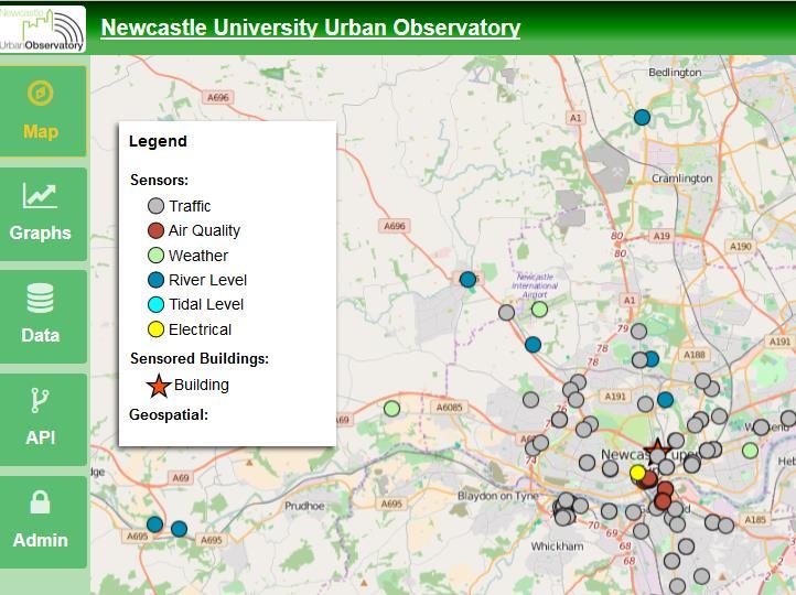


5 Infrastructure Systems Data New Opportunities & Challenges
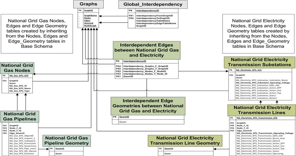
6 NISMOD-DB++ Prototype Design

7 NISMOD-DB++: Architecture NSIMOD-DB++ User API Models Web interfaces Admin interfaces Flexibility in type of databases employed Database to fit the data Access controlled through a single database
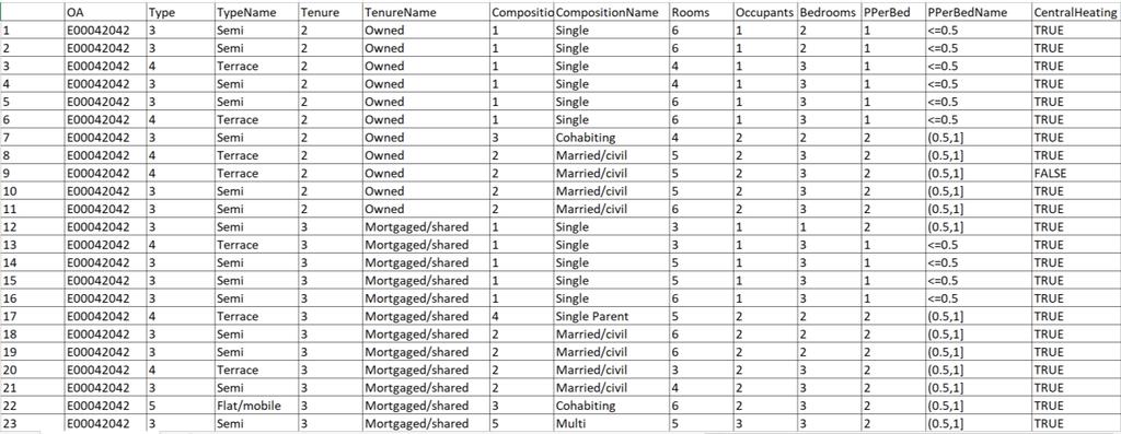
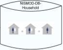
8 NISMOD-DB++: A Newcastle Pilot NISMOD-DB-Households
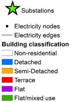
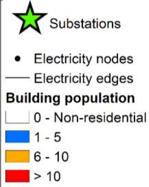

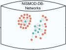
9 NISMOD-DB++: A Newcastle Pilot NISMOD-DB-Networks
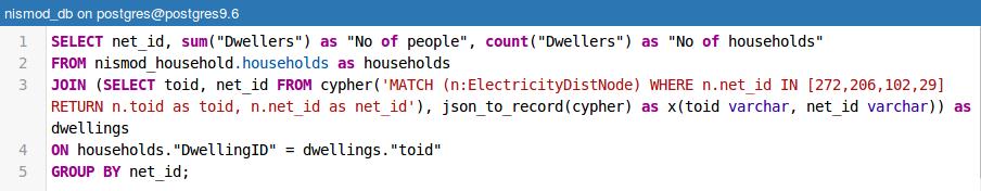

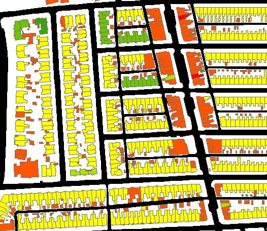
10 NISMOD-DB++: A Newcastle Pilot Hybrid Queries Find the number of people and number of households who are dependent on different electricity sub-stations.
11 Ji s Research City Scale Networks Spatial heuristic algorithm for generating fine scale urban infrastructure networks. Digital representation of urban infrastructure networks to understand spatial connectivity, local energy demand, and aggregation of infrastructure service flow. Database schema development to accommodate infrastructure networks to enable further applications.
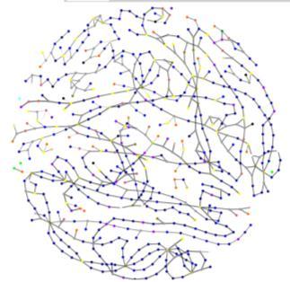
12 Spatial Heuristic Algorithm Haven t got spatial data for infrastructure networks? Want some advice for infrastructure network planning? Let s generate them spatially
13 Spatial Heuristic Algorithm Building Layout Substation Layout Road Network Spatial Heuristic Algorithm Distribution Network Layout
14 Spatial Heuristic Algorithm Results
15 Spatial Heuristic Algorithm Results The synthetic networks are rich in: Geometry Spatial Connectivity
")
16 Spatial Heuristic Algorithm Results City level distribution network generation (Newcastle) 657 Synthetic distribution networks Serving buildings Actual distribution network diagram (Northern Power Grid)


17 Ji s Future Work Database schema development Distribution Networks Database App for simulation or Analysis stored in Data Query API e.g. Electricity Distribution e.g. PostGIS / ITRC e.g. Simulation of voltage drops on feeder networks Database schema should be scalable and transferable enough to efficiently handle common queries on infrastructure networks of mega cities (such as London).


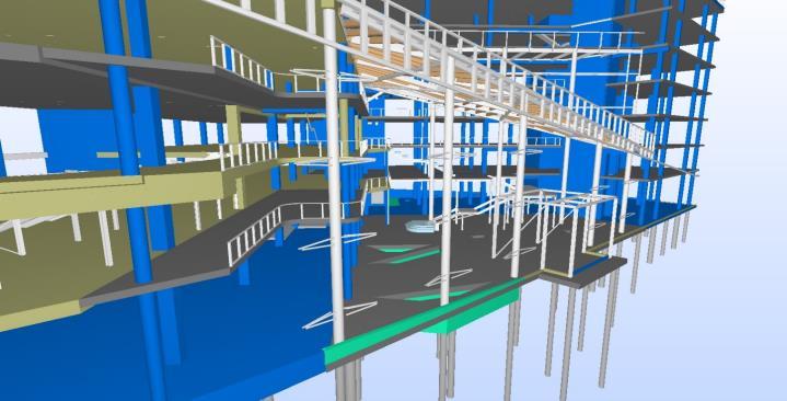
18 BIM, Infrastructure + Real Time Data Apache Kafka message broker Neo4j graph database JSON processor s Model parsers Link topic Node topic BIM Flow topic Ubuntu VM Local Node.JS web server Web browser GIS Web socket Web socket
19 UKCRIC DAFNI at Newcastle Data and Analytics Facility for National Infrastructure 8M national capability for infrastructure modelling, simulation and visualisation facilities Develop by UKCRIC Universities and STFC Harwell. Develop a national infrastructure modelling database capability. Provide many-task computing facilities. Facilitate coupling of simulation modules to enable system-of-systems simulation. Link with visualisation facilities to enable scrutiny and communication of complex and high dimensional simulation results. DAFNI s visualisation facilities, which will be located within participating universities as well as at Harwell to enable scrutiny of big datasets and complex model outputs.

20 UKCRIC DAFNI at Newcastle Co-develop with STFC A national infrastructure database: A secure facility for assembling, hosting and creating datasets on infrastructure assets and networks, and the human and natural environments in which they are located. Management of licence arrangements, and a commitment to Open Data, as far as possible, but with tiered security arrangements.
21 MISTRAL/DAFNI Opportunities DAFINI-Accelerator EPSRC 1M pump priming grant to crowd-in DAFNI development and use. Ordnance Survey working with NWl and UK Power Networks (CKI) on developing a national infrastructure assets register. NIC and ATI looking to develop a national digital twin pilot study probably at the neighbourhood scale over 6-months. IDBE initiative between OGC and Building-SMART to develop a integrated data standard for BIM/spatial data. Key to get infrastructure involved.
A National Scale Infrastructure Database and Modelling Environment for the UK
 A National Scale Infrastructure Database and Modelling Environment for the UK Stuart Barr a, David Alderson a, Craig Robson a, Alex Otto b, Jim Hall b, Scott Thacker b, Raghav Pant b. Presenting Author:
Using OGC standards to improve the common
 Using OGC standards to improve the common operational picture Abstract A "Common Operational Picture", or a, is a single identical display of relevant operational information shared by many users. The
Introduction to Portal for ArcGIS. Hao LEE November 12, 2015
 Introduction to Portal for ArcGIS Hao LEE November 12, 2015 Agenda Web GIS pattern Product overview Installation and deployment Security and groups Configuration options Portal for ArcGIS + ArcGIS for
Leveraging Web GIS: An Introduction to the ArcGIS portal
 Leveraging Web GIS: An Introduction to the ArcGIS portal Derek Law Product Management DLaw@esri.com Agenda Web GIS pattern Product overview Installation and deployment Configuration options Security options
Portal for ArcGIS: An Introduction. Catherine Hynes and Derek Law
 Portal for ArcGIS: An Introduction Catherine Hynes and Derek Law Agenda Web GIS pattern Product overview Installation and deployment Configuration options Security options and groups Portal for ArcGIS
ArcGIS Enterprise: What s New. Philip Heede Shannon Kalisky Melanie Summers Sam Williamson
 ArcGIS Enterprise: What s New Philip Heede Shannon Kalisky Melanie Summers Sam Williamson ArcGIS Enterprise is the new name for ArcGIS for Server What is ArcGIS Enterprise ArcGIS Enterprise is powerful
TOWARDS THE DEVELOPMENT OF A MONITORING SYSTEM FOR PLANNING POLICY Residential Land Uses Case study of Brisbane, Melbourne, Chicago and London
 TOWARDS THE DEVELOPMENT OF A MONITORING SYSTEM FOR PLANNING POLICY Residential Land Uses Case study of Brisbane, Melbourne, Chicago and London Presented to CUPUM 12 July 2017 by Claire Daniel Urban Planning/Data
Introduction to Portal for ArcGIS
 Introduction to Portal for ArcGIS Derek Law Product Management March 10 th, 2015 Esri Developer Summit 2015 Agenda Web GIS pattern Product overview Installation and deployment Security and groups Configuration
Tutorial: Urban Trajectory Visualization. Case Studies. Ye Zhao
 Case Studies Ye Zhao Use Cases We show examples of the web-based visual analytics system TrajAnalytics The case study information and videos are available at http://vis.cs.kent.edu/trajanalytics/ Porto
ArcGIS Enterprise: What s New. Philip Heede Shannon Kalisky Melanie Summers Shreyas Shinde
 ArcGIS Enterprise: What s New Philip Heede Shannon Kalisky Melanie Summers Shreyas Shinde ArcGIS Enterprise is the new name for ArcGIS for Server ArcGIS Enterprise Software Components ArcGIS Server Portal
INTRODUCTION. In March 1998, the tender for project CT.98.EP.04 was awarded to the Department of Medicines Management, Keele University, UK.
 INTRODUCTION In many areas of Europe patterns of drug use are changing. The mechanisms of diffusion are diverse: introduction of new practices by new users, tourism and migration, cross-border contact,
Portal for ArcGIS: An Introduction
 Portal for ArcGIS: An Introduction Derek Law Esri Product Management Esri UC 2014 Technical Workshop Agenda Web GIS pattern Product overview Installation and deployment Security and groups Configuration
Lesson 16: Technology Trends and Research
 http://www.esri.com/library/whitepapers/pdfs/integrated-geoenabled-soa.pdf GEOG DL582 : GIS Data Management Lesson 16: Technology Trends and Research Overview Learning Objective Questions: 1. Why is integration
Geog 469 GIS Workshop. Managing Enterprise GIS Geodatabases
 Geog 469 GIS Workshop Managing Enterprise GIS Geodatabases Outline 1. Why is a geodatabase important for GIS? 2. What is the architecture of a geodatabase? 3. How can we compare and contrast three types
GIS-based Smart Campus System using 3D Modeling
 GIS-based Smart Campus System using 3D Modeling Smita Sengupta GISE Advance Research Lab. IIT Bombay, Powai Mumbai 400 076, India smitas@cse.iitb.ac.in Concept of Smart Campus System Overview of IITB Campus
putting communities in control of their neighbourhood plan using new technologies
 putting communities in control of their neighbourhood plan using new technologies Richard Kingston Senior Lecturer in Urban Planning & Smart Cities Head of Planning & Environmental Management University
IDBE. Common conceptual framework and roadmap of collaboration in Spatial Standards for the Digital Built Environment
 IDBE Common conceptual framework and roadmap of collaboration in Spatial Standards for the Digital Built Environment GeoBIM: 3D GIS in China Mei Xue: In my opinion, what matters most in the integration
Data Aggregation with InfraWorks and ArcGIS for Visualization, Analysis, and Planning
 Data Aggregation with InfraWorks and ArcGIS for Visualization, Analysis, and Planning Stephen Brockwell President, Brockwell IT Consulting, Inc. Join the conversation #AU2017 KEYWORD Class Summary Silos
SPATIAL INFORMATION GRID AND ITS APPLICATION IN GEOLOGICAL SURVEY
 SPATIAL INFORMATION GRID AND ITS APPLICATION IN GEOLOGICAL SURVEY K. T. He a, b, Y. Tang a, W. X. Yu a a School of Electronic Science and Engineering, National University of Defense Technology, Changsha,
Road Ahead: Linear Referencing and UPDM
 Road Ahead: Linear Referencing and UPDM Esri European Petroleum GIS Conference November 7, 2014 Congress Centre, London Your Work Making a Difference ArcGIS Is Evolving Your GIS Is Becoming Part of an
ELF products in the ArcGIS platform
 ELF products in the ArcGIS platform Presentation to: Author: Date: NMO Summit 2016, Dublin, Ireland Clemens Portele 18 May 2016 The Building Blocks 18 May, 2016 More ELF users through affiliated platforms
ArcGIS is Advancing. Both Contributing and Integrating many new Innovations. IoT. Smart Mapping. Smart Devices Advanced Analytics
 ArcGIS is Advancing IoT Smart Devices Advanced Analytics Smart Mapping Real-Time Faster Computing Web Services Crowdsourcing Sensor Networks Both Contributing and Integrating many new Innovations ArcGIS
Overview of CityGML. Dave Capstick, Ordnance Survey Research Department
 Overview of CityGML Dave Capstick, Ordnance Survey Research Department Introduction Why is citygml necessary CityGML development who is responsible? Ordnance Surveys interest 3D modelling basic concepts
GENERALIZATION IN THE NEW GENERATION OF GIS. Dan Lee ESRI, Inc. 380 New York Street Redlands, CA USA Fax:
 GENERALIZATION IN THE NEW GENERATION OF GIS Dan Lee ESRI, Inc. 380 New York Street Redlands, CA 92373 USA dlee@esri.com Fax: 909-793-5953 Abstract In the research and development of automated map generalization,
Overview. Everywhere. Over everything.
 Cadenza Desktop Cadenza Web Cadenza Mobile Cadenza Overview. Everywhere. Over everything. The ultimate GIS and reporting suite. Provide, analyze and report data efficiently. For desktop, web and mobile.
One platform for desktop, web and mobile
 One platform for desktop, web and mobile Search and filter Get access to all data thematically filter data in context factually and spatially as well as display it dynamically. Export a selection or send
NATO Headquarters The Situation Center GIS experience.
 NATO Headquarters The Situation Center GIS experience. Abstract Recently, the dynamic capability of responding to a major world crisis with comprehensive in-depth information has become a crucial aspect
4D information management system for road maintenance using GIS
 icccbe 2010 Nottingham University Press Proceedings of the International Conference on Computing in Civil and Building Engineering W Tizani (Editor) 4D information management system for road maintenance
Harvard Center for Geographic Analysis Geospatial on the MOC
 2017 Massachusetts Open Cloud Workshop Boston University Harvard Center for Geographic Analysis Geospatial on the MOC Ben Lewis Harvard Center for Geographic Analysis Aaron Williams MapD Small Team Supporting
Web-GIS based Framework for Solid Waste Complaint Management for Sustainable and Smart City
 Cloud Publications International Journal of Advanced Remote Sensing and GIS 2016, Volume 5, Issue 10, pp. 1930-1936 ISSN 2320-0243, DOI: 10.23953/cloud.ijarsg.71 Research Article Open Access Web-GIS based
What s New. August 2013
 What s New. August 2013 Tom Schwartzman Esri tschwartzman@esri.com Esri UC2013. Technical Workshop. What is new in ArcGIS 10.2 for Server ArcGIS 10.2 for Desktop Major Themes Why should I use ArcGIS 10.2
Imagery and the Location-enabled Platform in State and Local Government
 Imagery and the Location-enabled Platform in State and Local Government Fred Limp, Director, CAST Jim Farley, Vice President, Leica Geosystems Oracle Spatial Users Group Denver, March 10, 2005 TM TM Discussion
Visualizing Big Data on Maps: Emerging Tools and Techniques. Ilir Bejleri, Sanjay Ranka
 Visualizing Big Data on Maps: Emerging Tools and Techniques Ilir Bejleri, Sanjay Ranka Topics Web GIS Visualization Big Data GIS Performance Maps in Data Visualization Platforms Next: Web GIS Visualization
LRS Task Force June 13, REVISION HISTORY
 North Carolina Department of Transportation Geographic Information Systems (GIS) Unit LINEAR REFERENCING SYSTEM (LRS) PROJECT DEFINITION Version 1.0 REVISION HISTORY Date Document Manager Revision Purpose
Spatial Analytics Workshop
 Spatial Analytics Workshop Pete Skomoroch, LinkedIn (@peteskomoroch) Kevin Weil, Twitter (@kevinweil) Sean Gorman, FortiusOne (@seangorman) #spatialanalytics Introduction The Rise of Spatial Analytics
Practical teaching of GIS at University of Liège
 Practical teaching of GIS at University of Liège Jean-Paul Kasprzyk, assistant Lessons Pr. Jean-Paul Donnay: For non-geographers (geologists, urban planners, engineers ) GIS users Master: Introduction
CHAPTER 22 GEOGRAPHIC INFORMATION SYSTEMS
 CHAPTER 22 GEOGRAPHIC INFORMATION SYSTEMS PURPOSE: This chapter establishes the administration and use of to improve the quality and accessibility of Department s spatial information and support graphical
Creating Basemaps to Manage Buildings and Facilities
 Esri International User Conference San Diego, California Technical Workshops July 26, 2012 Creating Basemaps to Manage Buildings and Facilities Mark Stewart and Tamara Yoder Topics for this Session Overview
ArcGIS GeoAnalytics Server: An Introduction. Sarah Ambrose and Ravi Narayanan
 ArcGIS GeoAnalytics Server: An Introduction Sarah Ambrose and Ravi Narayanan Overview Introduction Demos Analysis Concepts using GeoAnalytics Server GeoAnalytics Data Sources GeoAnalytics Server Administration
Enabling Web GIS. Dal Hunter Jeff Shaner
 Enabling Web GIS Dal Hunter Jeff Shaner Enabling Web GIS In Your Infrastructure Agenda Quick Overview Web GIS Deployment Server GIS Deployment Security and Identity Management Web GIS Operations Web GIS
Bentley Map Advancing GIS for the World s Infrastructure
 Bentley Map Advancing GIS for the World s Infrastructure Presentation Overview Why would you need Bentley Map? What is Bentley Map? Where is Bentley Map Used? Why would you need Bentley Map? Because your
GIS Supports to Economic and Social Development
 GIS Supports to Economic and Social Development Dang Van Duc and Le Quoc Hung Institute of Information Technology 18, Hoang Quoc Viet Rd., Cau Giay Dist., Hanoi, Vietnam Email: dvduc@ioit.ncst.ac.vn; lqhung@ioit.ncst.ac.vn
Data Aggregation with InfraWorks and ArcGIS for Visualization, Analysis, and Planning
 CI125230 Data Aggregation with InfraWorks and ArcGIS for Visualization, Analysis, and Planning Stephen Brockwell Brockwell IT Consulting Inc. Sean Kinahan Brockwell IT Consulting Inc. Learning Objectives
2011 Oracle Spatial Excellence Awards Presentation
 2011 Oracle Spatial Excellence Awards Presentation May 19, 2011 Ronald Reagan Building and International Trade Center Washington, DC USA Thanks to our sponsors Media Sponsor Media Participants Media Sponsor
INSPIRE - A Legal framework for environmental and land administration data in Europe
 INSPIRE - A Legal framework for environmental and land administration data in Europe Dr. Markus Seifert Bavarian Administration for Surveying and Cadastre Head of the SDI Office Bavaria Delegate of Germany
FINNISH LINKED DATA PILOTS
 FINNISH LINKED DATA PILOTS Kai Koistinen Data Linking by Indirect Reference Systems -workshop 5.9.2018 1 NLS FINLAND National Land Survey of Finland National mapping and cadastral agency Geodetic research
Spatial Analysis in CyberGIS
 Spatial Analysis in CyberGIS towards a spatial econometrics workbench Luc Anselin, Sergio Rey and Myunghwa Hwang GeoDa Center School of Geographical Sciences and Urban Planning Arizona State University
Investigating the practical relationship between GIS and BIM; then relating that to a 3D cadastre. J. Gabriel van Wyk, Johan Nel
 Investigating the practical relationship between GIS and BIM; then relating that to a 3D cadastre. J. Gabriel van Wyk, Johan Nel Overview So exactly what is BIM? Available BIM offerings in the market Traditional
GIS Integration to Maximo
 GIS Integration to Maximo Tuesday 15 th January 2008 Mahmoud Jaafar Systems Director GISTEC Agenda Introduction Why AMS & GIS Integration? ESRI GIS Enabling Technology. Integrating GIS & Maximo. What do
Web Visualization of Geo-Spatial Data using SVG and VRML/X3D
 Web Visualization of Geo-Spatial Data using SVG and VRML/X3D Jianghui Ying Falls Church, VA 22043, USA jying@vt.edu Denis Gračanin Blacksburg, VA 24061, USA gracanin@vt.edu Chang-Tien Lu Falls Church,
Oak Ridge Urban Dynamics Institute
 Oak Ridge Urban Dynamics Institute Presented to ORNL NEED Workshop Budhendra Bhaduri, Director Corporate Research Fellow July 30, 2014 Oak Ridge, TN Our societal challenges and solutions are often local
The Importance of Geospatial in the Construction Industry. 10 December, 2015
 The Importance of Geospatial in the Construction Industry 10 December, 2015 Transformation will drive Build Operate Reduce Total Cost of Use Increased design freedom to deliver better infrastructure Reduce
Global Geospatial Information Management Country Report Finland. Submitted by Director General Jarmo Ratia, National Land Survey
 Global Geospatial Information Management Country Report Finland Submitted by Director General Jarmo Ratia, National Land Survey Global Geospatial Information Management Country Report Finland Background
Making spatial data available on the desktop
 Making spatial data available on the desktop Loch Lomond and The Trossachs National Park Authority (LLTNPA) Sally Newton GIS Manager Francis Corbett GIS Systems Officer Where we were in 2010 What we wanted
Features and Benefits
 Autodesk LandXplorer Features and Benefits Use the Autodesk LandXplorer software family to help improve decision making, lower costs, view and share changes, and avoid the expense of creating physical
3D Urban Information Models in making a smart city the i-scope project case study
 UDC: 007:528.9]:004; 007:912]:004; 004.92 DOI: 10.14438/gn.2014.17 Typology: 1.04 Professional Article 3D Urban Information Models in making a smart city the i-scope project case study Dragutin PROTIĆ
European Location Framework data in the ArcGIS platform
 European Location Framework data in the ArcGIS platform Presentation to: Author: Date: INSPIRE Conference 2016 Clemens Portele 26 September 2016 Why ELF? Global (e.g. UN GGIM) Regional Europe (INSPIRE
Working with ArcGIS Online
 Esri International User Conference San Diego, CA Technical Workshops July 12, 2011 Working with ArcGIS Online Bern Szukalski, Deane Kensok Topics for this Session ArcGIS Online Overview ArcGIS Online Content
Integrating Official Statistics and Geospatial Information NBS Experience
 Integrating Official Statistics and Geospatial Information NBS Experience Presented by Eng. Reda AL Sabbagh Director of IT Dept. Prepared by Eng. Adham Makky GIS Specialist Topics to be covered: Background
What are we like? Population characteristics from UK censuses. Justin Hayes & Richard Wiseman UK Data Service Census Support
 What are we like? Population characteristics from UK censuses Justin Hayes & Richard Wiseman UK Data Service Census Support Who are we? Richard Wiseman UK Data Service / Jisc Justin Hayes UK Data Service
Abstract. Interoperable Framework for Mobile Dynamic Surveying based on open source components
 Interoperable Framework for Mobile Dynamic Surveying based on open source components Sergiusz Pawlowicz, Didier Leibovici, Richard Saull±, Mike Jackson, Chaoyu Ye, Wenchao Jiang, Natalie Adams 1, Suchith
Esri and GIS Education
 Esri and GIS Education Organizations Esri Users 1,200 National Government Agencies 11,500 States & Regional Agencies 30,800 Cities & Local Governments 32,000 Businesses 8,500 Utilities 12,600 NGOs 11,000
Personal Field Data Collection by UM-FieldGIS (Integration of Google Map API to Mobile GIS)
") Personal Field Data Collection by UM-FieldGIS (Integration of Google Map API to Mobile GIS) Ko Ko Lwin*. Yuji MURAYAMA* *Division of Spatial Information Science Graduate School of Life and Environmental
Personal Field Data Collection by UM-FieldGIS (Integration of Google Map API to Mobile GIS) Ko Ko Lwin*. Yuji MURAYAMA* *Division of Spatial Information Science Graduate School of Life and Environmental
Ministry of Health and Long-Term Care Geographic Information System (GIS) Strategy An Overview of the Strategy Implementation Plan November 2009
 Strategy An Overview of the Strategy Implementation Plan November 2009") Ministry of Health and Long-Term Care Geographic Information System (GIS) Strategy An Overview of the Strategy Implementation Plan November 2009 John Hill, Health Analytics Branch Health System Information
Ministry of Health and Long-Term Care Geographic Information System (GIS) Strategy An Overview of the Strategy Implementation Plan November 2009 John Hill, Health Analytics Branch Health System Information
US National Spatial Data Infrastructure A Spatial Framework for Governance and Policy Development to Enable a Location-Based Digital Ecosystem
 GeoPlatform Workshop 7 Dec 2016, Department of the Interior Washington, D.C. US National Spatial Infrastructure A Spatial Framework for Governance and Policy Development to Enable a Location-Based Digital
ESRI Survey Summit August Clint Brown Director of ESRI Software Products
 ESRI Survey Summit August 2006 Clint Brown Director of ESRI Software Products Cadastral Fabric How does Cadastral fit with Survey? Surveyors process raw field observations Survey measurements define high-order
Methodological Chain for Hydrological Management with Web-GIS Applications
 Advances in Geosciences Konstantinos Perakis & Athanasios Moysiadis, Editors EARSeL, 2012 Methodological Chain for Hydrological Management with Web-GIS Applications Alexandros Konstantinidis 1, Eleni Tzanou
ArcGIS. for Server. Understanding our World
 ArcGIS for Server Understanding our World ArcGIS for Server Create, Distribute, and Manage GIS Services You can use ArcGIS for Server to create services from your mapping and geographic information system
Testing of Geoportals: INSPIRE demands and challenges
 Testing of Geoportals: INSPIRE demands and challenges Imad Abugessaisa & Solgerd Tanzilli Lantmäteriet - Swedish Mapping, Cadastre and Land Registration Authority / Future Position X, Gävle INSPIRE 2010
THE DESIGN AND IMPLEMENTATION OF A WEB SERVICES-BASED APPLICATION FRAMEWORK FOR SEA SURFACE TEMPERATURE INFORMATION
 THE DESIGN AND IMPLEMENTATION OF A WEB SERVICES-BASED APPLICATION FRAMEWORK FOR SEA SURFACE TEMPERATURE INFORMATION HE Ya-wen a,b,c, SU Fen-zhen a, DU Yun-yan a, Xiao Ru-lin a,c, Sun Xiaodan d a. Institute
Voices from Private Sector: Insights for Future NSDI Development in Indonesia
 Voices from Private Sector: Insights for Future NSDI Development in Indonesia Ta n d a n g Yu l i a d i D w i P u t ra, Ryosuke S h i b a s a k i I n st i t u t e o f I n d u st r i a l S c i e n c e,
Pushing the Standards Edge: Collaborative Testbeds to Accelerate Standards Development and Implementation
 Pushing the Standards Edge: Collaborative Testbeds to Accelerate Standards Development and Implementation Mark E. Reichardt President mreichardt@opengeospatial.org 31 October 2006 2006 Open Geospatial
You are Building Your Organization s Geographic Knowledge
 You are Building Your Organization s Geographic Knowledge And Increasingly Making it Available Sharing Data Publishing Maps and Geo-Apps Developing Collaborative Approaches Citizens Knowledge Workers Analysts
Web GIS & ArcGIS Pro. Zena Pelletier Nick Popovich
 Web GIS & ArcGIS Pro Zena Pelletier Nick Popovich Web GIS Transformation of the ArcGIS Platform Desktop Apps GIS Web Maps Web Scenes Layers Evolution of the modern GIS Desktop GIS (standalone GIS) GIS
Understanding and accessing 2011 census aggregate data
 Understanding and accessing 2011 census aggregate data 4 July 11:00 to 16:00 BST Justin Hayes and Richard Wiseman UK Data Service Census Support UK censuses provide an unparalleled resource of high quality
Key Points Sharing fosters participation and collaboration Metadata has a big role in sharing Sharing is not always easy
 Sharing Resources Geoff Mortson esri, Inc. SDI Solutions Team Key Points Sharing fosters participation and collaboration Metadata has a big role in sharing Sharing is not always easy Data Sharing is Good
BIM and INSPIRE, for a better integration of built infrastructures in their environment : the MINnD project
 BIM and INSPIRE, for a better integration of built infrastructures in their environment : the MINnD project François ROBIDA Christophe CASTAING Strasbourg, > 1 8 septembre 2017 ABOUT BIM Building Information
GIS FOR MAZOWSZE REGION - GENERAL OUTLINE
 GIS FOR MAZOWSZE REGION - GENERAL OUTLINE S. Bialousz 1), K Mączewski 2), E. Janczar 2), K. Osinska-Skotak 1) 1) Warsaw University of Technology, Warsaw, Poland 2) Office of the Surveyor of the Mazowieckie
An Ontology-based Framework for Modeling Movement on a Smart Campus
 An Ontology-based Framework for Modeling Movement on a Smart Campus Junchuan Fan 1, Kathleen Stewart 1 1 Department of Geographical and Sustainability Sciences, University of Iowa, Iowa City, IA, 52242,
A Prototype of a Web Mapping System Architecture for the Arctic Region
 A Prototype of a Web Mapping System Architecture for the Arctic Region Han-Fang Tsai 1, Chih-Yuan Huang 2, and Steve Liang 3 GeoSensorWeb Laboratory, Department of Geomatics Engineering, University of
CENSUS MAPPING WITH GIS IN NAMIBIA. BY Mrs. Ottilie Mwazi Central Bureau of Statistics Tel: October 2007
 CENSUS MAPPING WITH GIS IN NAMIBIA BY Mrs. Ottilie Mwazi Central Bureau of Statistics E-mail: omwazi@npc.gov.na Tel: + 264 61 283 4060 October 2007 Content of Presentation HISTORICAL BACKGROUND OF CENSUS
The Challenge of Geospatial Big Data Analysis
 288 POSTERS The Challenge of Geospatial Big Data Analysis Authors - Teerayut Horanont, University of Tokyo, Japan - Apichon Witayangkurn, University of Tokyo, Japan - Shibasaki Ryosuke, University of Tokyo,
National GIS Platform for Digital India. Dr.(Mrs.) Vandana Sharma Deputy Director General National Informatics Centre
 Vandana Sharma Deputy Director General National Informatics Centre") National GIS Platform for Digital India Dr.(Mrs.) Vandana Sharma Deputy Director General National Informatics Centre sharma.vandana@nic.in NIC DEITY - National e-governance Infrastructure Meghraj Cloud
National GIS Platform for Digital India Dr.(Mrs.) Vandana Sharma Deputy Director General National Informatics Centre sharma.vandana@nic.in NIC DEITY - National e-governance Infrastructure Meghraj Cloud
Creation of an Internet Based Indiana Water Quality Atlas (IWQA)
") Department of Environmental Management Creation of an Internet Based Water Quality Atlas (IWQA) May 4, 2005 IUPUI 1200 Waterway Blvd., Suite 100 polis, 46202-5140 Water Quality Atlas John Buechler, Neil
Department of Environmental Management Creation of an Internet Based Water Quality Atlas (IWQA) May 4, 2005 IUPUI 1200 Waterway Blvd., Suite 100 polis, 46202-5140 Water Quality Atlas John Buechler, Neil
DataShine Automated Thematic Mapping of 2011 Census Quick Statistics
 DataShine Automated Thematic Mapping of 2011 Census Quick Statistics Oliver O Brien, James Cheshire Department of Geography University College London UKDS Census Applications Conference, July 2015 Contents
Global 3D Models with Local Content
 Gunnar Misund Associate Professor Head of Environmental Computing gunnar.misund@hiof.no - Morten Granlund, Scientfic Assistant Herman Kolås, Master Student Mats Lindh, Master Student - Østfold University
Improving Geographical Data Finder Using Tokenize Approach from GIS Map API
 Improving Geographical Data Finder Using Tokenize Approach from GIS Map API Antveer Kaur Department of computer science Banasthali University, Jaipur, Rajasthan, India bntsnghbrr940@gmail.com Shweta Kumari
INSPIRE implementation in the Turkish Ministry of Environment and Urbanization Producing and Publishing Environmental Data
 INSPIRE implementation in the Turkish Ministry of Environment and Urbanization Producing and Publishing Environmental Data Ezgi Sarmusak Urban Planner, MoEU Sibel Süer Toybıyık - Assistant Expert, MoEU
EXPECTATIONS OF TURKISH ENVIRONMENTAL SECTOR FROM INSPIRE
 EXPECTATIONS OF TURKISH ENVIRONMENTAL SECTOR FROM INSPIRE June, 2010 Ahmet ÇİVİ Tuncay DEMİR INSPIRE in the Eyes of MoEF Handling of Geodata by MoEF Benefits Expected TEIEN First Steps for INSPIRE Final
Animating Maps: Visual Analytics meets Geoweb 2.0
 Animating Maps: Visual Analytics meets Geoweb 2.0 Piyush Yadav 1, Shailesh Deshpande 1, Raja Sengupta 2 1 Tata Research Development and Design Centre, Pune (India) Email: {piyush.yadav1, shailesh.deshpande}@tcs.com
GIS at UCAR. The evolution of NCAR s GIS Initiative. Olga Wilhelmi ESIG-NCAR Unidata Workshop 24 June, 2003
 GIS at UCAR The evolution of NCAR s GIS Initiative Olga Wilhelmi ESIG-NCAR Unidata Workshop 24 June, 2003 Why GIS? z z z z More questions about various climatological, meteorological, hydrological and
June 19 Huntsville, Alabama 1
 June 19 Huntsville, Alabama 1 Real-Time Geospatial Data: The Fusion of PI and ArcGIS Enabling Smarter Facilities Management OSIsoft and Esri Mapping and Location Analytics Platform Supporting Your Use
GEOGRAPHICAL STATISTICS & THE GRID
 GEOGRAPHICAL STATISTICS & THE GRID Rich Harris, Chris Brunsdon and Daniel Grose (Universities of Bristol, Leicester & Lancaster) http://rose.bris.ac.uk OUTLINE About Geographically Weighted Regression
Information System as a Tool for Marine Spatial Planning The SmartSea Vision and a Prototype
 Information System as a Tool for Marine Spatial Planning The SmartSea Vision and a Prototype Ari Jolma Marine Research Centre Finnish Environment Institute May 10, 2017 ISESS 2017, Zadar, Croatia Contents
THE 3D SIMULATION INFORMATION SYSTEM FOR ASSESSING THE FLOODING LOST IN KEELUNG RIVER BASIN
 THE 3D SIMULATION INFORMATION SYSTEM FOR ASSESSING THE FLOODING LOST IN KEELUNG RIVER BASIN Kuo-Chung Wen *, Tsung-Hsing Huang ** * Associate Professor, Chinese Culture University, Taipei **Master, Chinese
MODERNIZATION OF THE MUNICIPAL MAPPING USING HIGH END GNSS SYSTEM AND GIS SOFTWARE
 MODERNIZATION OF THE MUNICIPAL MAPPING USING HIGH END GNSS SYSTEM AND GIS SOFTWARE Mr. R. A. R. Khan Assistant Engineer, Sewerage Utility Management Centre (SUMC) Municipal Corporation Of Greater Mumbai
MapOSMatic: city maps for the masses
 MapOSMatic: city maps for the masses Thomas Petazzoni Libre Software Meeting July 9th, 2010 Outline 1 The story 2 MapOSMatic 3 Behind the web page 4 Pain points 5 Future work 6 Conclusion Thomas Petazzoni
COSMIC: COmplexity in Spatial dynamic
 COSMIC: COmplexity in Spatial dynamic MICs 9 10 November, Brussels Michael Batty University College London m.batty@ucl.ac.uk http://www.casa.ucl.ac.uk/ Outline The Focus of the Pilot The Partners: VU,
THE SPATIAL DATA WAREHOUSE OF SEOUL
 THE SPATIAL DATA WAREHOUSE OF SEOUL Jae-Ho Han The Seoul Metropolitan Government Seoul City Hall, Taepyeongno 1(il)-ga, Jung-gu, Seoul 100-744, Korea djhjha@hanmail.net Impyeong Lee Dept. of Geoinformatics,
Integrating Geographic Information System and. Building Information Model for Real Estate Valuation. Haicong Yu Ying Liu
 Integrating Geographic Information System and Presented at the FIG Working Week 2016, May 2-6, 2016 in Christchurch, New Zealand TS02H - Mass Appraisal & Real Estate Taxation in a Changing World Building