TOWARDS THE DEVELOPMENT OF A MONITORING SYSTEM FOR PLANNING POLICY Residential Land Uses Case study of Brisbane, Melbourne, Chicago and London
|
|
|
- Adele Whitehead
- 6 years ago
- Views:
Transcription

1 TOWARDS THE DEVELOPMENT OF A MONITORING SYSTEM FOR PLANNING POLICY Residential Land Uses Case study of Brisbane, Melbourne, Chicago and London Presented to CUPUM 12 July 2017 by Claire Daniel Urban Planning/Data Science


2 ABOUT ME
3 THE PROJECT How can planning can take advantage of relatively recent technology for the storage, processing and display of large amounts of data (big data) in an automated and ongoing fashion for the purposes of monitoring the development of the city? Prototype focused on residential land-uses only
4 MONITORING IN THEORY Evaluation occurs at three stages: Before the plan Evaluation of alternative policy options and future scenarios. During the plan Ongoing monitoring After the plan Looking back at overall impacts


5 EVALUATION IN PRACTICE When it comes to evaluation most effort in system building is put towards predictions and projections, evaluating the future. Urban Sim SLEUTH Model Spatial Interaction Models London Land Release Model Key assumption: policy is going to work the way it is intended, that the rules will be followed


6 MONITORING IN PRACTICE Monitoring and evaluation into the actual effects of past planning policy is comparatively largely neglected. Where monitoring is undertaken it tends to be reported as citywide statistics without much detail
7 MONITORING IN PRACTICE Reasons include lack of resources, established methods and indicators, and political and organisational will. Difficulties are also found untangling the complexity of planning objectives, defining success, reconciling measurements, managing stakeholder interests and allowing enough time for policy effects to show.

8 CASE STUDY CITIES Chicago London Brisbane Melbourne Planning systems vary from regulatory to discretionary
9 CONCEPTUAL STRUCTURE OF MONITORING SYSTEM Component 1 Base Case Establish what exists Component 2 - Change Establish what has changed Component 3 Metrics How well does change meet policy objectives? Land Use Data Development Data Infrastructure Location Data Component 4 Visualisation and Communication How to present monitoring information and measurements effectively?
10 PRACTICAL STRUCTURE OF MONITORING SYSTEM Raw data on file Images Server R Scripts 1. Data cleaning and formatting R Scripts 2. Units of analysis and visualization methods 3. Calculation of metrics HTML, JavaScript Libraries, Google Maps API Interactive browserbased visualization MySQL to R interface with RODBC & RMySQL packages MySQL Calculated metrics MySQL Node.js express API


11 DEVELOPMENT DATA Establishing LAND USE what - DATA has changed QUALITY AND PROCESSING Brisbane London Chicago Melbourne Brisbane City Council Land Use Activity Dataset Ordnance Survey Address Base Plus Chicago Metropolitan Agency for Planning Land Use Inventory Melbourne City Census of Land Use and Employment Data Processing for Chicago Land use 2010 Land Parcels 2010 Census blocks 2010 Modelled land use Use Codes
 Brisbane")

 Brisbane (n=15,036) What requires approval?")
12 DEVELOPMENT DEVELOPMENT DATA DATA Establishing Establishing what has what changed has changed DEVELOPMENT DATA - DATA QUALITY AND PROCESSING London (n=34,035) Brisbane Brisbane City Council Building Completions Certificates London Greater London Authority London Development Database Chicago City of Chicago Building Permits Melbourne City of Melbourne Development Activity Monitor Melbourne City Census of Land Use and Employment count of developments Chicago (n=11,390) Brisbane (n=15,036) What requires approval? Has it been built?

13 VISUALISATION CHLOROPLETH MAP Preserving and making sense of spatial patterns Dwellings developed since 2010 by ward
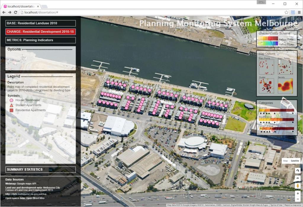
14 VISUALISATION POINT MAP Preserving and making sense of spatial patterns Location of completed schemes since 2010

15 VISUALISATION CLUSTERS Preserving and making sense of spatial patterns Number of Dwellings by Cluster

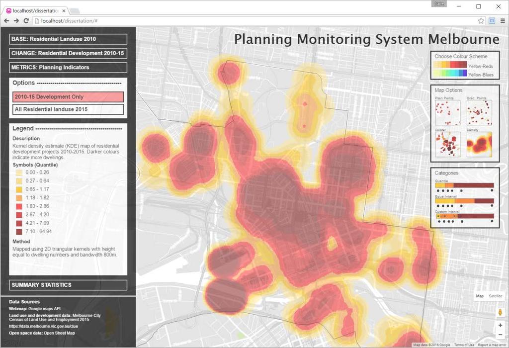
16 VISUALISATION KERNEL DENSITY MAP Preserving and making sense of spatial patterns Aggregate of kernels Number of dwellings 800m Bandwidth a b c d e

17 VISUALISATION KERNEL DENSITY MAP Preserving and making sense of spatial patterns
 North Melbourne")
 North Melbourne Carlton N 1km")
18 DENSITY PROFILE RELATIVE CHANGE Existing Land Use 2011 (Base Case) North Melbourne Carlton N 1km 2km N 1km 2km Percent Change ( ) North Melbourne Carlton N 1km 2km

19 METRICS DWELLING MIX Attached and detached dwellings N 10km 20km

20 METRICS DWELLING MIX Number of Bedrooms N 10km 20km

21 METRICS PROXIMITY TO SERVICES Melbourne, proximity to parks N 1km 2km N 1km 2km Number of parks in a buffer distance Distance along road network


22 METRICS PROXIMITY TO SERVICES Chicago, proximity to public transport (GTFS data) Number of public transport services per stop from 06:00 to 09:00 on a Wednesday, City of Chicago Distance along road network to a public transport stop serviced on average at least every 10 minutes or more during morning peak hour (new development sites).
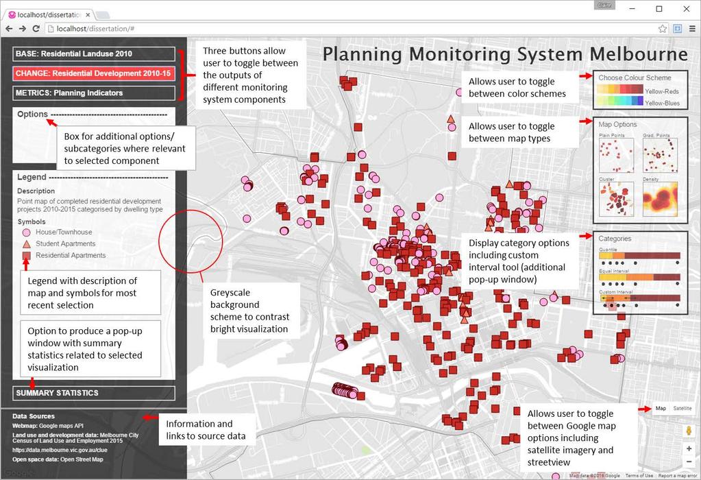
23 WEB VISULISATION
24
25 CONCLUSIONS AND FINAL THOUGHTS Hundreds of ways to program these kind of metrics Prototype monitoring system a demonstration of some of the things that can be done to get a spatially detailed picture showing which areas are relatively successful in achieving planning goals. Data attributes often reflect the administrative procedures required to process an application and are not necessarily the best for ongoing monitoring purposes. Data entry is often done by people who will not see the value of the outputs. This does not in itself define success what level or measure is considered acceptable is defined politically Achieves monitoring in an ongoing fashion, updating automatically when new data becomes available Cuts out a lot of labour intensive work otherwise making the task impossible. More testing to be done regarding usability The prototype shows that it is technically feasible, however, existing manual and digital administrative systems would need to change to make it easy in practice.
26
Joint MISTRAL/CESI lunch workshop 15 th November 2017
 MISTRAL@Newcastle Joint MISTRAL/CESI lunch workshop 15 th November 2017 ITRC at Newcastle ITRC at Newcastle MISTRAL at Newcastle New approach to infrastructure data management to open-up analytics, modelling
ArcGIS Enterprise: What s New. Philip Heede Shannon Kalisky Melanie Summers Sam Williamson
 ArcGIS Enterprise: What s New Philip Heede Shannon Kalisky Melanie Summers Sam Williamson ArcGIS Enterprise is the new name for ArcGIS for Server What is ArcGIS Enterprise ArcGIS Enterprise is powerful
Geodatabase for Sustainable Urban Development. Presented By Rhonda Maronn Maurice Johns Daniel Ashney Jack Anliker
 Geodatabase for Sustainable Urban Development Presented By Rhonda Maronn Maurice Johns Daniel Ashney Jack Anliker Objective Build a Geodatabase that will enable urban planners to create and assess the
Transport Planning in Large Scale Housing Developments. David Knight
 Transport Planning in Large Scale Housing Developments David Knight Large Scale Housing Developments No longer creating great urban spaces in the UK (Hall 2014) Transport Planning Transport planning processes
BROOKINGS May
 Appendix 1. Technical Methodology This study combines detailed data on transit systems, demographics, and employment to determine the accessibility of jobs via transit within and across the country s 100
Chapter 6. Fundamentals of GIS-Based Data Analysis for Decision Support. Table 6.1. Spatial Data Transformations by Geospatial Data Types
 Chapter 6 Fundamentals of GIS-Based Data Analysis for Decision Support FROM: Points Lines Polygons Fields Table 6.1. Spatial Data Transformations by Geospatial Data Types TO: Points Lines Polygons Fields
Digital Tax Maps Westport Island Project Summary
 Digital Tax Maps Westport Island Project Summary Presented to the: Mid-Coast Regional Planning Commission Creating GIS-Based Digital Tax Maps And Linked Assessment Records For Small Towns on a Budget Dennis
StreamStats: Delivering Streamflow Information to the Public. By Kernell Ries
 StreamStats: Delivering Streamflow Information to the Public By Kernell Ries U.S. Department of the Interior U.S. Geological Survey MD-DE-DC District 410-238-4317 kries@usgs.gov StreamStats Web Application
Geostatistics and Spatial Scales
 Geostatistics and Spatial Scales Semivariance & semi-variograms Scale dependence & independence Ranges of spatial scales Variable dependent Fractal dimension GIS implications Spatial Modeling Spatial Analysis
A GIS TOUR OF DES MOINES PRESENTED BY ANNA WHIPPLE, GIS MANAGER APRIL 20, 2015
 A GIS TOUR OF DES MOINES PRESENTED BY ANNA WHIPPLE, GIS MANAGER APRIL 20, 2015 Welcome to Des Moines! Capital of Iowa Among 100 largest metropolitan areas Insurance, biotech, healthcare, and entertainment
GIS Geographical Information Systems. GIS Management
 GIS Geographical Information Systems GIS Management Difficulties on establishing a GIS Funding GIS Determining Project Standards Data Gathering Map Development Recruiting GIS Professionals Educating Staff
GIS ADMINISTRATOR / WEB DEVELOPER EVANSVILLE-VANDERBURGH COUNTY AREA PLAN COMMISSION
 GIS ADMINISTRATOR / WEB DEVELOPER EVANSVILLE-VANDERBURGH COUNTY AREA PLAN COMMISSION SALARY RANGE INITIATION $43,277 SIX MONTHS $45,367 POSITION GRADE PAT VI The Evansville-Vanderburgh County Area Plan
An Open Source Tool for the Visualization, Analysis and Reporting of Regional and Statewide Transit Networks
 An Open Source Tool for the Visualization, Analysis and Reporting of Regional and Statewide Transit Networks Saeed Ghanbartehrani Department of Industrial and Systems Engineering, Ohio University J. David
CALOTS Upgrade for Performance Monitoring
 CALOTS Upgrade for Performance Monitoring A project of the Southern California Association of Governments supported by the UCLA Lewis Center for Regional Policy Studies Agenda 1. Revisit Project Overview
Digitization in a Census
 Topics Connectivity of Geographic Data Sketch Maps Data Organization and Geodatabases Managing a Digitization Project Quality and Control Topology Metadata 1 Topics (continued) Interactive Selection Snapping
Interactive Visualization Tool (InViTo)
") Interactive Visualization Tool (InViTo) Stefano Pensa To cite this report: Stefano Pensa (2012) Interactive Visualization Tool (InViTo), in Angela Hull, Cecília Silva and Luca Bertolini (Eds.) Accessibility
Interactive Visualization Tool (InViTo) Stefano Pensa To cite this report: Stefano Pensa (2012) Interactive Visualization Tool (InViTo), in Angela Hull, Cecília Silva and Luca Bertolini (Eds.) Accessibility
Smart Solutions for Spatial Planning
 Smart Solutions for Spatial Planning Aedas R&D [Computational Design Research] Centre for Evolutionary Computing in Architecture [CECA @ UEL] Knowledge Transfer [breaking silos] * constructing consensus
The Road to Data in Baltimore
 Creating a parcel level database from high resolution imagery By Austin Troy and Weiqi Zhou University of Vermont, Rubenstein School of Natural Resources State and local planning agencies are increasingly
A Method for Mapping Settlement Area Boundaries in the Greater Golden Horseshoe
 A Method for Mapping Settlement Area Boundaries in the Greater Golden Horseshoe Purpose This paper describes a method for mapping and measuring the lands designated for growth and urban expansion in the
3D - Boulder Valley Comprehensive Plan. Lesli Ellis Comprehensive Planning Manager City of Boulder
 3D - Boulder Valley Comprehensive Plan Lesli Ellis Comprehensive Planning Manager City of Boulder Presentation Boulder s use of 3D GIS and other tools in Comprehensive Planning (e.g., story maps, CityEngine,
Spatial Statistical Information Services in KOSTAT
 Distr. GENERAL WP.30 12 April 2010 ENGLISH ONLY UNITED NATIONS ECONOMIC COMMISSION FOR EUROPE (UNECE) CONFERENCE OF EUROPEAN STATISTICIANS EUROPEAN COMMISSION STATISTICAL OFFICE OF THE EUROPEAN UNION (EUROSTAT)
What are we like? Population characteristics from UK censuses. Justin Hayes & Richard Wiseman UK Data Service Census Support
 What are we like? Population characteristics from UK censuses Justin Hayes & Richard Wiseman UK Data Service Census Support Who are we? Richard Wiseman UK Data Service / Jisc Justin Hayes UK Data Service
Merging statistics and geospatial information
 Merging statistics and geospatial information Demography / Commuting / Spatial planning / Registers Mirosław Migacz Chief GIS Specialist Janusz Dygaszewicz Director Central Statistical Office of Poland
Presented by: Bryan Bloch GIS Specialist DNREC Division of Watershed Stewardship
 Presented by: Bryan Bloch GIS Specialist DNREC Division of Watershed Stewardship Bryan Hall, AICP Sussex County Circuit Rider Planner, Office of State Planning Coordination, OMB November 19, 2012 UD Sustainable
How GIS based Visualizations Support Land Use and Transportation Modeling
 How GIS based Visualizations Support Land Use and Transportation Modeling ESRI International Users Conference San Diego, CA - July 23, 2015 Prepared by: Troy Hightower Introduction This presentation will
Chapter 5. GIS The Global Information System
 Chapter 5 GIS The Global Information System What is GIS? We have just discussed GPS a simple three letter acronym for a fairly sophisticated technique to locate a persons or objects position on the Earth
Features and Benefits
 Autodesk LandXplorer Features and Benefits Use the Autodesk LandXplorer software family to help improve decision making, lower costs, view and share changes, and avoid the expense of creating physical
King City URA 6D Concept Plan
 King City URA 6D Concept Plan King City s Evolution Among the fastest growing cities 2000 Census 1,949 2010 Census 3,111 60% increase 2016 Census estimate 3,817 23% increase Average annual rate 4.3% Surpassing
Attachment 3. Updating UBC s Regional Context Statement. University of British Columbia CONSIDERATION MEMORANDUM OF CONSULTATION INPUT
 Attachment 3 University of British Columbia Updating UBC s Regional Context Statement CONSIDERATION MEMORANDUM OF CONSULTATION INPUT Campus and Community Planning February 24, 2014 1 CONSIDERATION MEMORANDUM
Land Accounts - The Canadian Experience
 Land Accounts - The Canadian Experience Development of a Geospatial database to measure the effect of human activity on the environment Who is doing Land Accounts Statistics Canada (national) Component
Neighborhood Locations and Amenities
 University of Maryland School of Architecture, Planning and Preservation Fall, 2014 Neighborhood Locations and Amenities Authors: Cole Greene Jacob Johnson Maha Tariq Under the Supervision of: Dr. Chao
ArcGIS Enterprise: What s New. Philip Heede Shannon Kalisky Melanie Summers Shreyas Shinde
 ArcGIS Enterprise: What s New Philip Heede Shannon Kalisky Melanie Summers Shreyas Shinde ArcGIS Enterprise is the new name for ArcGIS for Server ArcGIS Enterprise Software Components ArcGIS Server Portal
GIS for the Non-Expert
 GIS for the Non-Expert Ann Forsyth University of Minnesota February 2006 GIS for the Non-Expert 1. Definitions and problems 2. Measures being tested in Twin Cities Walking Study Basic approach, data, variables
Land Use in the context of sustainable, smart and inclusive growth
 Land Use in the context of sustainable, smart and inclusive growth François Salgé Ministry of sustainable development France facilitator EUROGI vice president AFIGéO board member 1 Introduction e-content+
The Building Blocks of the City: Points, Lines and Polygons
 The Building Blocks of the City: Points, Lines and Polygons Andrew Crooks Centre For Advanced Spatial Analysis andrew.crooks@ucl.ac.uk www.gisagents.blogspot.com Introduction Why use ABM for Residential
Assessing spatial distribution and variability of destinations in inner-city Sydney from travel diary and smartphone location data
 Assessing spatial distribution and variability of destinations in inner-city Sydney from travel diary and smartphone location data Richard B. Ellison 1, Adrian B. Ellison 1 and Stephen P. Greaves 1 1 Institute
High Speed / Commuter Rail Suitability Analysis For Central And Southern Arizona
 High Speed / Commuter Rail Suitability Analysis For Central And Southern Arizona Item Type Reports (Electronic) Authors Deveney, Matthew R. Publisher The University of Arizona. Rights Copyright is held
SPATIAL INEQUALITIES IN PUBLIC TRANSPORT AVAILABILITY: INVESTIGATION WITH SMALL-AREA METRICS
 SPATIAL INEQUALITIES IN PUBLIC TRANSPORT AVAILABILITY: INVESTIGATION WITH SMALL-AREA METRICS Research conducted by Yeran Sun and Piyushimita (Vonu) Thakuriah Presented by Obinna C.D. Anejionu INTRODUCTION
Global Geospatial Information Management Country Report Finland. Submitted by Director General Jarmo Ratia, National Land Survey
 Global Geospatial Information Management Country Report Finland Submitted by Director General Jarmo Ratia, National Land Survey Global Geospatial Information Management Country Report Finland Background
How the science of cities can help European policy makers: new analysis and perspectives
 How the science of cities can help European policy makers: new analysis and perspectives By Lewis Dijkstra, PhD Deputy Head of the Economic Analysis Unit, DG Regional and European Commission Overview Data
The integration of land change modeling framework FUTURES into GRASS GIS 7
 The integration of land change modeling framework FUTURES into GRASS GIS 7 Anna Petrasova, Vaclav Petras, Douglas A. Shoemaker, Monica A. Dorning, Ross K. Meentemeyer NCSU OSGeo Research and Education
Urban Spatial Scenario Design Modelling (USSDM) in Dar es Salaam: Background Information
 in Dar es Salaam: Background Information") Urban Spatial Scenario Design Modelling (USSDM) in Dar es Salaam: Background Information Modelling urban settlement dynamics in Dar es Salaam Revision: 2 (July 2013) Prepared by: Katja Buchta TUM team
Urban Spatial Scenario Design Modelling (USSDM) in Dar es Salaam: Background Information Modelling urban settlement dynamics in Dar es Salaam Revision: 2 (July 2013) Prepared by: Katja Buchta TUM team
Statistical-geospatial integration - The example of Sweden. Marie Haldorson Director, Statistics Sweden
 Statistical-geospatial integration - The example of Sweden Marie Haldorson Director, Statistics Sweden Spatial data and geospatial applications at Statistics Sweden Long tradition GI integrated in production
City of Chino Hills General Plan Update 13GPA02 Scoping Meeting. June 4, 2013
 13GPA02 Scoping Meeting June 4, 2013 Every California city must adopt a comprehensive, long-term general plan. The General Plan is the City s constitution or blueprint for its long-range physical development.
presents challenges related to utility infrastructure planning. Many of these challenges
 1 Introduction: - a. Purpose According to U.S. Census Bureau the population of stark county was 367,585 in 1990, and in 2000 it was increase to 378,098. Thus County is experiencing a growth that presents
Introduction to Field Data Collection
 Introduction to Field Data Collection Dr. Yuji Murayama (Professor) Dr. Ko Ko Lwin (JSPS Postdoctoral Researcher) Division of Spatial Information Science Graduate School of Life and Environmental Sciences
A Land Use Transport Model for Greater London:
 Spatio-Temporal Analysis of Network Data and Road Developments Launch Event Workshop UCL Monday 18 May 2009 A Land Use Transport Model for Greater London: With Applications to an Integrated Assessment
RESIDENTIAL SATISFACTION IN THE CHANGING URBAN FORM IN ADELAIDE: A COMPARATIVE ANALYSIS OF MAWSON LAKES AND CRAIGBURN FARM, SOUTH AUSTRALIA
 RESIDENTIAL SATISFACTION IN THE CHANGING URBAN FORM IN ADELAIDE: A COMPARATIVE ANALYSIS OF MAWSON LAKES AND CRAIGBURN FARM, SOUTH AUSTRALIA by Michael Chadbourne BEPM (Hons) University of Adelaide Thesis
GIS and Governing Anchorage. GIS Critical for Efficient, Transparent Government How is GIS Program Doing Where can GIS Program Take us
 GIS and Governing Anchorage GIS Critical for Efficient, Transparent Government How is GIS Program Doing Where can GIS Program Take us Municipality of Anchorage Office of Economic And Community Development
SA Geospatial Analysis Platform (GAP) Methodology*, collaborators & data sources
 Methodology*, collaborators & data sources") SA Geospatial Analysis Platform (GAP) Methodology*, collaborators & data sources Mesoframe CSIR, dti, the Presidency & GTZ Demarcation of South Africa into a grid of 50 Km 2 mesozones, nested within important
SA Geospatial Analysis Platform (GAP) Methodology*, collaborators & data sources Mesoframe CSIR, dti, the Presidency & GTZ Demarcation of South Africa into a grid of 50 Km 2 mesozones, nested within important
ESRI INTERNATIONAL USER CONFERENCE July 11 15, 2011 San Diego, CA - USA. Spatial analysis of health facilities in Yola, Nigeria, using GIS
 ESRI INTERNATIONAL USER CONFERENCE July 11 15, 2011 San Diego, CA - USA Spatial analysis of health facilities in Yola, Nigeria, using GIS Abdurrahman Belel ISMAILA 1 belelismaila@yahoo.com Nurünnisa USUL
Metrolinx Transit Accessibility/Connectivity Toolkit
 Metrolinx Transit Accessibility/Connectivity Toolkit Christopher Livett, MSc Transportation Planning Analyst Research and Planning Analytics Tweet about this presentation #TransitGIS OUTLINE 1. Who is
Contents. Ipswich City Council Ipswich Adopted Infrastructure Charges Resolution (No. 1) Page
 Page") Ipswich City Council Ipswich Adopted Infrastructure Charges Resolution (No. 1) 2014 Contents Page Part 1 Introduction 3 1. Short title 3 2. Commencement 3 3. Sustainable Planning Act 2009 3 4. Purpose
Ipswich City Council Ipswich Adopted Infrastructure Charges Resolution (No. 1) 2014 Contents Page Part 1 Introduction 3 1. Short title 3 2. Commencement 3 3. Sustainable Planning Act 2009 3 4. Purpose
FSUTMS Framework for Integrating Land Use Modeling
 FSUTMS Framework for Integrating Land Use Modeling presented to MTF Data Committee presented by Wade L. White, Whitehouse Group Walter Anderson, Whitehouse Group March 6, 2012 Agenda Background Previous
The Use of Geographic Information Systems (GIS) by Local Governments. Giving municipal decision-makers the power to make better decisions
 by Local Governments. Giving municipal decision-makers the power to make better decisions") The Use of Geographic Information Systems (GIS) by Local Governments Giving municipal decision-makers the power to make better decisions Case Study: Examples of GIS Usage by Local Governments in North
The Use of Geographic Information Systems (GIS) by Local Governments Giving municipal decision-makers the power to make better decisions Case Study: Examples of GIS Usage by Local Governments in North
Developing a Subdivision Build- Out Study and Site Suitability Tool; Enabling Access Through a Web GIS Application
 Developing a Subdivision Build- Out Study and Site Suitability Tool; Enabling Access Through a Web GIS Application DOUG SEXTON GEOG 596A SUMMER 2017 ADVISOR: DR. JAMES O BRIEN Project Outline Introduction
GIS and Remote Sensing Support for Evacuation Analysis
 GIS and Remote Sensing Support for Evacuation Analysis Presented to GIS for Transportation Symposium Rapid City, South Dakota March 28-31, 2004 Demin Xiong Oak Ridge National Laboratory 2360 Cherahala
ParkServe. The Trust for Public Land s. Emmalee Dolfi Gabriel Patterson-King ESRI User Conference 2017
 The Trust for Public Land s ParkServe Automating Large-Scale Data Transformation, QA/QC and Analysis Emmalee Dolfi Gabriel Patterson-King ESRI User Conference 2017 Our mission The Trust for Public Land
GIS Level 2. MIT GIS Services
 GIS Level 2 MIT GIS Services http://libraries.mit.edu/gis Email: gishelp@mit.edu TOOLS IN THIS WORKSHOP - Definition Queries - Create a new field in the attribute table - Field Calculator - Add XY Data
Army Installation Geospatial Information and Services (IGI&S) Program Overview
 Program Overview") Army Installation Geospatial Information and Services (IGI&S) Program Overview Joshua Delmonico Geospatial Information Officer OACSIM IGI&S Program 703-602-2851 Joshua.Delmonico@hqda.army.mil 1of 11 221400
Army Installation Geospatial Information and Services (IGI&S) Program Overview Joshua Delmonico Geospatial Information Officer OACSIM IGI&S Program 703-602-2851 Joshua.Delmonico@hqda.army.mil 1of 11 221400
1.1 What is Site Fingerprinting?
 Site Fingerprinting Utilizing GIS/GPS Technology 1.1 What is Site Fingerprinting? Site fingerprinting is a planning tool used to design communities where protection of natural resources is the primary
2040 MTP and CTP Socioeconomic Data
 SE Data 6-1 24 MTP and CTP Socioeconomic Data Purpose of Socioeconomic Data The socioeconomic data (SE Data) shows the location of the population and employment, median household income and other demographic
GOVERNMENT MAPPING WORKSHOP RECOVER Edmonton s Urban Wellness Plan Mapping Workshop December 4, 2017
 GOVERNMENT MAPPING WORKSHOP 12.4.17 RECOVER Edmonton s Urban Wellness Plan Mapping Workshop December 4, 2017 In July of 2017, City Council directed administration to develop RECOVER, Edmonton s Urban Wellness
Economic and Social Urban Indicators: A Spatial Decision Support System for Chicago Area Transportation Planning
 Economic and Social Urban Indicators: A Spatial Decision Support System for Chicago Area Transportation Planning Piyushimita Thakuriah (Vonu), P.S. Sriraj, Paul Metaxatos, Inshu Minocha & Tanushri Swarup
LBRS Ohio s Location-Based Response System
 LBRS Ohio s Location-Based Response System Comprised of state-level statewide datasets for Ohio, including road centerlines with point-based address locations, parcels, and orthophotography Spatially accurate
An Internet-Based Integrated Resource Management System (IRMS)
") An Internet-Based Integrated Resource Management System (IRMS) Third Quarter Report, Year II 4/1/2000 6/30/2000 Prepared for Missouri Department of Natural Resources Missouri Department of Conservation
An Internet-Based Integrated Resource Management System (IRMS) Third Quarter Report, Year II 4/1/2000 6/30/2000 Prepared for Missouri Department of Natural Resources Missouri Department of Conservation
Exploring Digital Welfare data using GeoTools and Grids
 Exploring Digital Welfare data using GeoTools and Grids Hodkinson, S.N., Turner, A.G.D. School of Geography, University of Leeds June 20, 2014 Summary As part of the Digital Welfare project [1] a Java
Chapter 12: Facilitating the National Infrastructure for Managing Land Information (NIMLI) through Spatial Metadata Automation
 through Spatial Metadata Automation") Chapter 12: Facilitating the National Infrastructure for Managing Land Information (NIMLI) through Spatial Automation Hamed Olfat Introduction As part of the National Infrastructure for Managing Land Information
Chapter 12: Facilitating the National Infrastructure for Managing Land Information (NIMLI) through Spatial Automation Hamed Olfat Introduction As part of the National Infrastructure for Managing Land Information
- World-wide cities are growing at a rate of 2% annually (UN 1999). - (60,3%) will reside in urban areas in 2030.
. - (60,3%) will reside in urban areas in 2030.") THE EFFECTIVENESS OF NEW TECHNOLOGIES FOR URBAN LAND MANAGEMENT BAHAAEDDINE I. AL HADDAD Centro de Política de Suelo y Valoraciones Universidad Politécnica de Cataluña Barcelona, España www.upc.es/cpsv
THE EFFECTIVENESS OF NEW TECHNOLOGIES FOR URBAN LAND MANAGEMENT BAHAAEDDINE I. AL HADDAD Centro de Política de Suelo y Valoraciones Universidad Politécnica de Cataluña Barcelona, España www.upc.es/cpsv
GEOGRAPHIC INFORMATION SYSTEM ANALYST I GEOGRAPHIC INFORMATION SYSTEM ANALYST II
 CITY OF ROSEVILLE GEOGRAPHIC INFORMATION SYSTEM ANALYST I GEOGRAPHIC INFORMATION SYSTEM ANALYST II DEFINITION To perform professional level work in Geographic Information Systems (GIS) management and analysis;
Transit Time Shed Analyzing Accessibility to Employment and Services
 Transit Time Shed Analyzing Accessibility to Employment and Services presented by Ammar Naji, Liz Thompson and Abdulnaser Arafat Shimberg Center for Housing Studies at the University of Florida www.shimberg.ufl.edu
CAPE FARM MAPPER - an integrated spatial portal
 CAPE FARM MAPPER - an integrated spatial portal Skukuza Dr Mike Wallace June 2017 Overview of GIS applications in WCDoA Spatial information and technology has become indispensable across a wide range of
Flood Hazard Zone Modeling for Regulation Development
 Flood Hazard Zone Modeling for Regulation Development By Greg Lang and Jared Erickson Pierce County GIS June 2003 Abstract The desire to blend current digital information with government permitting procedures,
GIS in Community & Regional Planning
 GIS in Community & Regional Planning The The role role of of GIS GIS in in Re-writing the the Zoning Bylaw for for the the City City of of Vernon LandInfo Technologies Presentation Overview The GIS Initiative
Integrated Modelling of the Spatial Impacts of Climate Change In Greater London
 Megacities, Vulnerability and Global Climate Change: FAPESP: City of São Paulo, July 20 th 22 nd 2009 Integrated Modelling of the Spatial Impacts of Climate Change In Greater London Michael Batty University
Houston Plat Tracker puts the GIS in Land Development
 Houston Plat Tracker puts the GIS in Land Development Abstract: The Plat Tracker supports Houston's land development approval process. This home grown web-based system includes GIS research tools and a
THE FUTURE OF FORECASTING AT METROPOLITAN COUNCIL. CTS Research Conference May 23, 2012
 THE FUTURE OF FORECASTING AT METROPOLITAN COUNCIL CTS Research Conference May 23, 2012 Metropolitan Council forecasts Regional planning agency and MPO for Twin Cities metropolitan area Operates regional
Crossing Boundaries Building Tools to Combine Public-Use (and Misaligned) Data
 Data") Crossing Boundaries Building Tools to Combine Public-Use (and Misaligned) Data Matthew Graham LEHD Program Center for Economic Studies U.S. Census Bureau 2018 FCSM Research and Policy Conference 1 Disclaimer
Crossing Boundaries Building Tools to Combine Public-Use (and Misaligned) Data Matthew Graham LEHD Program Center for Economic Studies U.S. Census Bureau 2018 FCSM Research and Policy Conference 1 Disclaimer
A tale of two cities. John Daley, CEO, Grattan Institute Work and life in cities: City strategy in Australia Melbourne Economic Forum 27 October 2016
 A tale of two cities John Daley, CEO, Grattan Institute Work and life in cities: City strategy in Australia Melbourne Economic Forum 27 October 2016 A tale of two cities Shifts in consumption are driving
Embracing ArcGIS Server Technology A City s Balanced Approach
 Embracing ArcGIS Server Technology A City s Balanced Approach Sridhar Katragadda Virginia Johnston Esri UC2013. About the City Virginia Beach Metropolitan Statistical Area (MSA) is the 38th largest in
Reducing Vulnerability to Extreme Heat: Science-Policy Interface
 Reducing Vulnerability to Extreme Heat: Science-Policy Interface Olga Wilhelmi, Mary Hayden, Jennifer Boehnert, Ursula Lauper and SIMMER research team October 23, 2013 Toronto SIMMER workshop Science-Policy
Web-GIS based Framework for Solid Waste Complaint Management for Sustainable and Smart City
 Cloud Publications International Journal of Advanced Remote Sensing and GIS 2016, Volume 5, Issue 10, pp. 1930-1936 ISSN 2320-0243, DOI: 10.23953/cloud.ijarsg.71 Research Article Open Access Web-GIS based
Digital Wetlands. Bringing the Field into the Office Through GIS
 Digital Wetlands Bringing the Field into the Office Through GIS Maryland Department of the Environment Wetlands and Waterways Program MDE's Wetlands and Waterways Program seeks to conserve valuable aquatic
Who are we? Use of German State s Rhineland-Palatinate Spatial Data Infrastructure for e-government INSPIRE. Topics of Presentation INSPIRE
 Who are we? University of Applied Sciences, Mainz, Germany Institute for Spatial Information and Surveying Technology Use of German State s Rhineland-Palatinate Spatial Data Infrastructure for e-government
McHenry County Property Search Sources of Information
 Disclaimer: The information in this system may contain inaccuracies or typographical errors. The information in this system is a digital representation of information derived from original documents; as
Operational Definitions of Urban, Rural and Urban Agglomeration for Monitoring Human Settlements
 Operational Definitions of Urban, Rural and Urban Agglomeration for Monitoring Human Settlements By Markandey Rai United Nations Human Settlements Programme PO Box-30030 Nairobi, Kenya Abstract The United
Orbital Insight Energy: Oil Storage v5.1 Methodologies & Data Documentation
 Orbital Insight Energy: Oil Storage v5.1 Methodologies & Data Documentation Overview and Summary Orbital Insight Global Oil Storage leverages commercial satellite imagery, proprietary computer vision algorithms,
Population 24/7. David Martin, University of Southampton
 Population 24/7 David Martin, University of Southampton Demographics User Group 18 March 2011 Presentation overview Acknowledgement: Samantha Cockings and Samuel Leung; ESRC award RES-062-23-181 Small
If you aren t familiar with Geographical Information Systems (GIS), you. GIS, when combined with a database that stores response information,
, you. GIS, when combined with a database that stores response information,") Geographical Information Systems in EMS By William E. Ott If you aren t familiar with Geographical Information Systems (GIS), you should take a look at what GIS can offer you as an EMS manager. GIS, when
Geographical Information Systems in EMS By William E. Ott If you aren t familiar with Geographical Information Systems (GIS), you should take a look at what GIS can offer you as an EMS manager. GIS, when
City Models to Explore the Impact of New Urban Infrastructures
 June 29 th 2016 City Models to Explore the Impact of New Urban Infrastructures Michael Batty m.batty@ucl.ac.uk @jmichaelbatty http://www.complexcity.info/ http://www.spatialcomplexity.info/ My Main Themes
3D Urban Information Models in making a smart city the i-scope project case study
 UDC: 007:528.9]:004; 007:912]:004; 004.92 DOI: 10.14438/gn.2014.17 Typology: 1.04 Professional Article 3D Urban Information Models in making a smart city the i-scope project case study Dragutin PROTIĆ
Globally Estimating the Population Characteristics of Small Geographic Areas. Tom Fitzwater
 Globally Estimating the Population Characteristics of Small Geographic Areas Tom Fitzwater U.S. Census Bureau Population Division What we know 2 Where do people live? Difficult to measure and quantify.
Overview. Project Background Project Approach: Content and Application Development Application Demonstration Future Developments
 Overview Project Background Project Approach: Content and Application Development Application Demonstration Future Developments Southeast Pressures: Continued Population Growth Transportation Corridors
Exploring representational issues in the visualisation of geographical phenomenon over large changes in scale.
 Institute of Geography Online Paper Series: GEO-017 Exploring representational issues in the visualisation of geographical phenomenon over large changes in scale. William Mackaness & Omair Chaudhry Institute
Accessibility to urban areas of different sizes
 Working paper/pm 2010:10 Accessibility to urban areas of different sizes - Modelling through indexed accessibility The Swedish Agency for Growth Policy Analysis has developed a tool for measuring and analysing
Calibrated Virtual Urban Water Systems software tool for one partner city. Software
 Calibrated Virtual Urban Water Systems software tool for one partner city Software COLOPHON Title Calibrated Virtual Urban Water Systems software tool for one partner city - Software Report number: PREPARED
ENV208/ENV508 Applied GIS. Week 1: What is GIS?
 ENV208/ENV508 Applied GIS Week 1: What is GIS? 1 WHAT IS GIS? A GIS integrates hardware, software, and data for capturing, managing, analyzing, and displaying all forms of geographically referenced information.
APPENDIX I: Traffic Forecasting Model and Assumptions
 APPENDIX I: Traffic Forecasting Model and Assumptions Appendix I reports on the assumptions and traffic model specifications that were developed to support the Reaffirmation of the 2040 Long Range Plan.
McHenry County Property Search Sources of Information
 Disclaimer: The information in this system may contain inaccuracies or typographical errors. The information in this system is a digital representation of information derived from original documents; as
NOACA s DART: Web GIS Tools for Transportation Planning. Chad Harris, NOACA Bryan Baker, Tierra Plan LLC Kevin Knapp, Tierra Plan LLC
 NOACA s DART: Web GIS Tools for Transportation Planning Chad Harris, NOACA Bryan Baker, Tierra Plan LLC Kevin Knapp, Tierra Plan LLC NOACA DART: Data Analysis and Reporting Tool NOACA: Northeast Ohio Areawide