Ecological Valuation for Land Use Planning Decision Support in South Florida: The Ecosystem Portfolio Model
|
|
|
- Eric Atkins
- 5 years ago
- Views:
Transcription

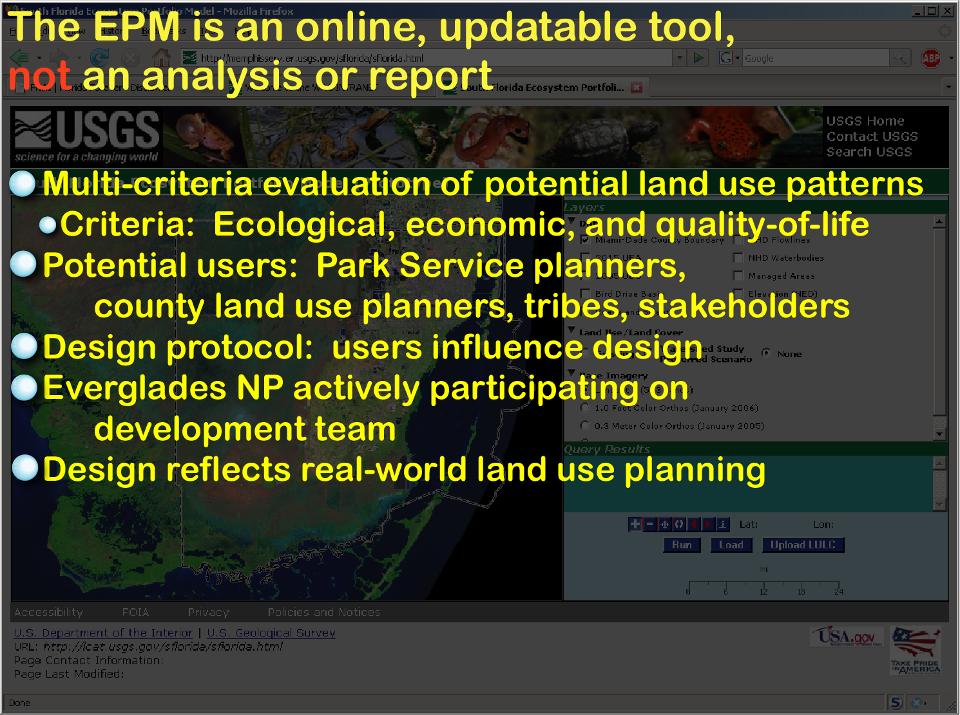
1 Ecological Valuation for Land Use Planning Decision Support in South Florida: The Ecosystem Portfolio Model Bill Labiosa, Rich Bernknopf, Paul Hearn, Dianna Hogan, Dave Strong, Leonard Pearlstine, Amy Mathie, Kevin Gillen, Anne Wein, and Susan Wachter U.S. Department of the Interior U.S. Geological Survey ACES Conference December 9, 2008
2 Outline Ecosystem Portfolio Model background EPM components: ecological value, land price, quality-of-life Comparing land use plans with the EPM Next steps

3 EPM Purpose: Incorporating ecosystem values into land use planning decision support Proposed Developments UDB Biscayne NP Everglades NP Agriculture Agriculture Miami-Dade County Pilot Proposed Development Turkey Point Nuclear Plant
4


5 How the EPM works 1. Multiple land use plans considered 2. Evaluated against multiple criteria Model-based characterization of outcomes Ecological Value Model Land Price Model 3. Value maps combine user-elicited value judgments and criteria scores Quality-of of-life Value Map Land Price Map Ecological Value Map Habitat, Fragmentation Water quality Restoration Multi-attribute utility valuation Parcel prices, Price drivers Quality-of-Life Indicators Affordability, Risks, Open space,
6 Multi-attribute utility (MAU) valuation Value Alternative 0.8 to cost-benefit analysis Can 0.7 be used when outcomes are highly uncertain 0.6 Does 0.5 not require monetization to assign value Does 0.4 not require (but can make use of) economic 0.3 valuation approaches Used 0.2 in deliberative decision-making processes 0.1 involving Outcome stakeholders to construct values Model-based score (characterization)
7 EPM components (models) Ecological Value Model Land Price Model Habitat, Fragmentation Water quality Restoration Parcel prices, Price drivers Quality-of-Life Indicators Affordability, Risks, Open space,


8 Ecological Value Model USGS Florida GAP Habitat suitability model Biodiversity Potential Criterion Florida Natural Areas Inventory (FNAI) Rare & Unique Habitats Criterion Fragmentation & Patterns Criterion FRAGSTATS metrics MAU Value Map Cell-wise Aggregate Ecological Value USFWS Multi- Species Recovery Plan model Threatened & Endangered Species Criterion Attribute-based based Ranking model Attribute-based based Ranking model Restoration Potential Water Quality Buffer Potential Criterion Criterion
 Reveals how environmental and ecological amenities affect land prices Land Price Model Parcel prices, Price drivers Determined")
9 Land price (hedonic) model What drives parcel prices? Statistical analysis of real land market transactions ( ) Reveals how environmental and ecological amenities affect land prices Land Price Model Parcel prices, Price drivers Determined drivers Parcel characteristics (zoning, size) Development restrictions (environmental, infrastructure, water needs) Measured (GIS) distance to amenities
10 Community Quality-of-Life Indicators Map-based representations of: Community population and development densities Infrastructure inventory, condition, and needs (flood control structures, roads, armoring Flood/storm surge risks (sea level rise impact scenarios) Recreational opportunities, accessibility, use Green/open space/natural areas Housing price/affordability indices Beach/nearshore character (set of indicators) Community character (set of indicators) Multi-attribute utility function for QOL indicators Affordability, Risks, Open space,
11 Comparing land use plans with the EPM


 Upload custom LU plan 3) Modify")
12 Inputting land use plans, proposed developments, proposed restoration projects, Current land use/cover, county master plan, Watershed Study Preferred Scenario for 2050, X 1) Load LU plan from menu 2) Upload custom LU plan 3) Modify loaded plan through interface


13 Using the EPM to compare landscapes: Running the models Value Ecological Value Model Criteria Multi-attribute Criteria Weights utility parameters Outcome Model-based score (characterization)
14 Ways to evaluate and compare landscapes Cell-based value map comparisons Aggregate ecological value maps (MAU) Individual ecological criterion value maps Community Quality-of-Life indicator maps Predicted land price maps (parcels) Value map statistics Area of interest User-defined grid Variety of statistics Queries Find cells that meet conditions

15 Example: Comparing current landscape to 2050 Watershed Study Plan Ag and low-density development to higher-density development Land density use development changes between current use and 2050 Plan New parks Ag to Commercial


16 Comparing landscapes: Aggregate ecological value maps Avg, median, Std dev, percentiles Current 2050

17 Current land use vs plan: Biodiversity potential value map Avg, median, Std dev, percentiles Current 2050


18 Science tools: Exploring under the hood DRIs Cohesion Core Area Shape


19 Decision-making tools: Queries and trade-offs Find ecological restoration potential > 7 and land price < 10 $/sq_ft Land price map
20 Future work Collaborating with Florida International University and Florida Atlantic University to develop Quality-of-Life indicators component Evaluating key scenarios with the EPM Detailed sea level rise scenarios being developed Simulated future urbanization under demographic scenarios
21 EPM contributors PIs (USGS): Bill Labiosa, Rich Bernknopf, Paul Hearn USGS core team: Dianna Hogan, Amy Mathie, Dave Strong, Anne Wein National Park Service: Leonard Pearlstine*, Dave Hallac, Sarah Bellmund, Linda Friar US FWS: Patrick Pitts, Les Vilchek USGS BRD: Don DeAngelis Univ. of Florida: Frank Mozzotti, Leonard Pearlstine* Miami-Dade Env Resources: G. Burzycki Miami-Dade Planning and Zoning: S. Basu Univ. of Pennsyvlania Wharton School: Kevin Gillen, Susan Wachter, Paul Amos Florida Atlantic Univ: A-M Esnard Florida Int l Univ: Hugh Gladwin, Jennifer Borum Funders: USGS PES, NPS CESI, USGS GAM EPM website: User: sflorida Password: alligator
Assessment and valuation of Ecosystem Services for decision-makers
 Assessment and valuation of Ecosystem Services for decision-makers An introduction to the ARIES approach Ferdinando Villa *, Ken Bagstad Gary Johnson, Marta Ceroni *Basque Center for Climate Change, Bilbao,
Fig 1. Steps in the EcoValue Project
 Assessing the Social and Economic Value of Ecosystem Services in the Northern Forest Region: A Geographic Information System (GIS) Approach to Landscape Valuation Principal Investigator(s): Dr. Matthew
Presented by: Bryan Bloch GIS Specialist DNREC Division of Watershed Stewardship
 Presented by: Bryan Bloch GIS Specialist DNREC Division of Watershed Stewardship Bryan Hall, AICP Sussex County Circuit Rider Planner, Office of State Planning Coordination, OMB November 19, 2012 UD Sustainable
Summary Description Municipality of Anchorage. Anchorage Coastal Resource Atlas Project
 Summary Description Municipality of Anchorage Anchorage Coastal Resource Atlas Project By: Thede Tobish, MOA Planner; and Charlie Barnwell, MOA GIS Manager Introduction Local governments often struggle
Ecological Land Cover Classification For a Natural Resources Inventory in the Kansas City Region, USA
 Ecological Land Cover Classification For a Natural Resources Inventory in the Kansas City Region, USA by Applied Ecological Services, Inc. In cooperation with the Mid-America Regional Council 600 Broadway,
AUTOMATED ONLINE ECOLOGICAL MODELING AND EVALUATION FOR EVERGLADES MANAGEMENT AND RESTORATION
 AUTOMATED ONLINE ECOLOGICAL MODELING AND EVALUATION FOR EVERGLADES MANAGEMENT AND RESTORATION Leonard Pearlstine 1 Suresh Goldconda 2 Kevin Suir 3 Alicia LoGalbo 1 Craig Conzelmann 3 Janice Parsons 1 1
ESTIMATING THE SOCIAL & ENVIRONMENTAL EFFECTS OF ADVENTURE TOURISM AND RECREATION ON CROWN LAND IN BRITISH COLUMBIA
 ESTIMATING THE SOCIAL & ENVIRONMENTAL EFFECTS OF ADVENTURE TOURISM AND RECREATION ON CROWN LAND IN BRITISH COLUMBIA Wolfgang Haider School of Resource and Environmental Mgt. Simon Fraser University Burnaby,
SPLAN-Natura Towards an integrated spatial planning approach for Natura th January, 2017 Brussels. Commissioned by DG Environment
 SPLAN-Natura 2000 Towards an integrated spatial planning approach for Natura 2000 Commissioned by DG Environment 17 th January, 2017 Brussels V. Simeonova (Ph.D.) Drivers towards integrating Biodiversity
Landscape Planning and Habitat Metrics
 Landscape Planning and Habitat Metrics Frank W. Davis National Center for Ecological Analysis and Synthesis UC Santa Barbara (Tools for Landscape Biodiversity Planning) Jimmy Kagan Institute for Natural
NetRA Resources Assessment (NetRA) 1
 1") NetRA Resources Assessment (NetRA) 1 Dadhi Ram Adhikari Economist 2 Christopher Babis -Water Resources Policy Richard L. Bernknopf- Economist Craig D. Broadbent- Economist David S. Brookshire- Economist
NetRA Resources Assessment (NetRA) 1 Dadhi Ram Adhikari Economist 2 Christopher Babis -Water Resources Policy Richard L. Bernknopf- Economist Craig D. Broadbent- Economist David S. Brookshire- Economist
Creating a framework for mapping opportunity space to enhance ecological resilience in Wales
 Creating a framework for mapping opportunity space to enhance ecological resilience in Wales Dr Katie Medcalf CEnv MCIEEM MBSSS Why place matters To get a resilient Wales we need to maximise the benefit
MPOs SB 375 LAFCOs SCAG Practices/Experiences And Future Collaborations with LAFCOs
 Connecting LAFCOs and COGs for Mutual Benefits MPOs SB 375 LAFCOs SCAG Practices/Experiences And Future Collaborations with LAFCOs Frank Wen, Manager Research & Analysis Land Use & Environmental Planning
European Topic Centre on Land Urban and Soil Systems. Green Infrastructure at EEA
 Green Infrastructure at EEA A SPATIAL APPROACH TO MAPPING GI Stefan Kleeschulte, ETC ULS GI and territorial cohesion 2011 first EEA report on Green Infrastructure Underlining the need to develop tools
Land Use in the context of sustainable, smart and inclusive growth
 Land Use in the context of sustainable, smart and inclusive growth François Salgé Ministry of sustainable development France facilitator EUROGI vice president AFIGéO board member 1 Introduction e-content+
Regional Sediment Management
 Regional Sediment Management Linda S. Lillycrop Program Manager Coastal Engineer US Army Engineer Research and Development Center Coastal and Hydraulics Laboratory Q AVG Coastal Resilience: The Environmental,
Reducing Vulnerability to Extreme Heat: Science-Policy Interface
 Reducing Vulnerability to Extreme Heat: Science-Policy Interface Olga Wilhelmi, Mary Hayden, Jennifer Boehnert, Ursula Lauper and SIMMER research team October 23, 2013 Toronto SIMMER workshop Science-Policy
Free State Provincial Biodiversity Assessment
 Free State Provincial Biodiversity Assessment Presentation at: Biodiversity Planning Forum; 22 25 May 2013 Golden Gate Highlands National Park Nacelle Collins Department of Economic Development, Tourism
Population Trends Along the Coastal United States:
 Coastal Trends Report Series Population Trends Along the Coastal United States: 1980-2008 U.S. Department of Commerce National Oceanic and Atmospheric Administration National Ocean Service Assessing the
Stephanie J. Connolly Forest Soil Scientist
 Stephanie J. Connolly Forest Soil Scientist Approximately 1 million acres High elevation Steep slopes Rain shadow effect Hydrologically shallow soils Sedimentary geology Acidic environments Biodiversity
Land Accounts - The Canadian Experience
 Land Accounts - The Canadian Experience Development of a Geospatial database to measure the effect of human activity on the environment Who is doing Land Accounts Statistics Canada (national) Component
Great California Delta Trail Blueprint for Contra Costa and Solano Counties GIS AND MAPPING MEMORANDUM JULY 2010
 Great California Delta Trail Blueprint for Contra Costa and Solano Counties GIS AND MAPPING MEMORANDUM JULY 2010 {DRAFT} July 2010 Introduction Geographic Information Systems (GIS) are computer-based
Mapping and Assessment of Ecosystems and their Services
 Mapping and Assessment of Ecosystems and their Services ALTER-Net Conference 2013: Science underpinning the EU 2020 Biodiversity Strategy. April 2013 Gent Joachim MAES 1 This presentation is based on the
Key Indicators for Territorial Cohesion & Spatial Planning Stakeholder Workshop - Project Update. 13 th December 2012 San Sebastián, Basque Country
 Key Indicators for Territorial Cohesion & Spatial Planning Stakeholder Workshop - Project Update 13 th December 2012 San Sebastián, Basque Country Key Aims Explore the use of territorial data in developing
How to make the European landscape climate-change proof for biodiversity? Prof. Paul Opdam
 How to make the European landscape climate-change proof for biodiversity? Prof. Paul Opdam Notions Habitat fragmentation and land use prevent species to respond to climate change Adaptation of the landscape
NOAA s OCM: Services, tools and collaboration opportunities & Puerto Rico s NE Marine Corridor as a case study
 NOAA s OCM: Services, tools and collaboration opportunities & Puerto Rico s NE Marine Corridor as a case study Dr. Antares Ramos Álvarez NOAA s Office of Coastal Management September 15 th, 2016 Conservation
Social Values for Ecosystem Services (SolVES)
") Social Values for Ecosystem Services (SolVES) Presented to the Chesapeake Bay Program Scientific, Technical Assessment and Reporting (STAR) Team Meeting Annapolis, Maryland November 5, 2012 US Department
Social Values for Ecosystem Services (SolVES) Presented to the Chesapeake Bay Program Scientific, Technical Assessment and Reporting (STAR) Team Meeting Annapolis, Maryland November 5, 2012 US Department
EnviroAtlas: An Atlas about Ecosystems and their Connection with People
 EnviroAtlas: An Atlas about Ecosystems and their Connection with People Annie Neale, Megan Mehaffey & Atlas Team ASWM Webinar October, 17 th, 2012 What is it? The Atlas is an online decision support tool
Incorporating GIS into Hedonic Pricing Models
 Blanchette 1 Alex Blanchette NRS 509 12/10/2016 Incorporating GIS into Hedonic Pricing Models One of the central themes in environmental economics is determining the value individuals derive from various
Developing urban ecosystem accounts for Great Britain. Emily Connors Head of Natural Capital Accounting Office for National Statistics (UK)
") Developing urban ecosystem accounts for Great Britain Emily Connors Head of Natural Capital Accounting Office for National Statistics (UK) UN 2014 UN 2014 ONS 2017 UK motivation 54% 82% 5,900 Of the world
Developing urban ecosystem accounts for Great Britain Emily Connors Head of Natural Capital Accounting Office for National Statistics (UK) UN 2014 UN 2014 ONS 2017 UK motivation 54% 82% 5,900 Of the world
Chapter 6. Fundamentals of GIS-Based Data Analysis for Decision Support. Table 6.1. Spatial Data Transformations by Geospatial Data Types
 Chapter 6 Fundamentals of GIS-Based Data Analysis for Decision Support FROM: Points Lines Polygons Fields Table 6.1. Spatial Data Transformations by Geospatial Data Types TO: Points Lines Polygons Fields
Quantifying and Valuing Floodplain Nutrient and Sediment Retention
 Quantifying and Valuing Floodplain Nutrient and Sediment Retention Krissy Hopkins, Dianna Hogan, Emily Pindilli, Greg Noe, Fabiano Franco, and Stephanie Gordon A Community on Ecosystem Services December
3/29/11. Why bother with tools? Incorporating Decision Support Tools into Climate Adaptation Planning. A Simplified Planning Process
 Incorporating Decision Support Tools into Climate Adaptation Planning Why bother with tools? Tools don t eliminate complexity but they can help deal with it" Tools can:"! Help incorporate science into
Policy-oriented ES-research in Belgium: progress and prospects
 Policy-oriented ES-research in Belgium: progress and prospects Vilm 12.10.2011 Sander Jacobs 1, Wouter Van Reeth², Jan Staes 1 & Patrick Meire 1 1 University of Antwerp, ecosystem management research group
GIS Solutions in Natural Resource Management: Balancing the Technical- Political Equation
 GIS Solutions in Natural Resource Management: Balancing the Technical- Political Equation Stan Morain, Editor SUB Gdttlngen 7 208 520 309 98 A14447 0NW0RD PRESS V? % \
Planning for Sea Level Rise in the Matanzas Basin
 Planning for Sea Level Rise in the Matanzas Basin Appendix E: Matanzas Future Development Scenarios June, 2015 Prepared by: Dr. Paul Zwick University of Florida Department of Urban and Regional Planning
EcoServ-GIS. EcoServ GIS Stage I. Why EcoServ GIS? 17/12/2012
 EcoServ-GIS Ecosystem Services Mapping: A Wildlife Trust GIS Toolkit to map ecosystem services at a county scale Dr Jonathan Winn Living Landscape Coordinator Durham Wildlife Trust Dr Chloe Bellamy Ecosystem
Sea level rise Web GIS Applications
 Florida International University FIU Digital Commons GIS Center GIS Center 2018 Sea level rise Web GIS Applications Zhaohui Fu GIS-RS Center, Florida International University, Fujen@fiu.edu Sheyla Santana
How GIS based Visualizations Support Land Use and Transportation Modeling
 How GIS based Visualizations Support Land Use and Transportation Modeling ESRI International Users Conference San Diego, CA - July 23, 2015 Prepared by: Troy Hightower Introduction This presentation will
GI AND WATERSHED MANAGEMENT: Discussing GI relevance Towards monitoring EU Legal Framework
 DGT- Direcção Geral do Território GI AND WATERSHED MANAGEMENT: Discussing GI relevance Towards monitoring EU Legal Framework Maria José Vale and Raquel Saraiva INSPIRE CONFERENCE 2012 ISTAMBUL Summary
Chapter : 1 : Introduction of GIS
 History of GIS : Chapter : 1 : Introduction of GIS In 1960 the Department of Forestry and Rural Department of Canada has decided to pursue a large-scale project to manage the resources. The initial task
An Internet-based Agricultural Land Use Trends Visualization System (AgLuT)
") An Internet-based Agricultural Land Use Trends Visualization System (AgLuT) Prepared for Missouri Department of Natural Resources Missouri Department of Conservation 07-01-2000-12-31-2001 Submitted by
An Internet-based Agricultural Land Use Trends Visualization System (AgLuT) Prepared for Missouri Department of Natural Resources Missouri Department of Conservation 07-01-2000-12-31-2001 Submitted by
Exploring the provision of ecosystem services through rural landscape management: a development of conceptual framework
 Exploring the provision of ecosystem services through rural landscape management: a development of conceptual framework Rovai M., Bartolini F., Fastelli L., Brunori G. Department of Agriculture, Food and
GALVESTON BAY RSM Moving toward an Integrated, Cooperative, and Holistic Approach to Estuarine Sediments
 GALVESTON BAY RSM Moving toward an Integrated, Cooperative, and Holistic Approach to Estuarine Sediments RAE Conference 2010 Larry A. Wise Moffatt & Nichol RSM is a system-based approach for collaboratively
Is Ignoring Evolution Intelligent Design for Conservation? Mark Reynolds, Gretchen LeBuhn, Dick Cameron, and Rebecca Shaw
 Is Ignoring Evolution Intelligent Design for Conservation? Mark Reynolds, Gretchen LeBuhn, Dick Cameron, and Rebecca Shaw Outline Evolution and Conservation Practice Biodiversity Pattern and Process Global
Designing Networks of Marine Protected Areas in DFO s Three Atlantic Bioregions
 Designing Networks of Marine Protected Areas in DFO s Three Atlantic Bioregions Presentation for Indigenous Protected Areas Workshop Max Westhead, DFO and Adrian Gerhartz-Abraham, Dalhousie March 29, 2017
Committee Meeting November 6, 2018
 Committee Meeting November 6, 2018 Agenda Where we are in the process Land Use Plan Transportation Element Housing & Neighborhoods Elements Next Steps Schedule November 6: Plan Elements December: Plan
ROSS ECOSYSTEM VALUATION FRAMEWORK. TECHNICAL WORK SESSION June 12 th, 2013 FRAMEWORK DEVELOPMENT TO SUPPORT DECISION MAKING
 ECOSYSTEM VALUATION FRAMEWORK ROSS TECHNICAL WORK SESSION June 12 th, 2013 FRAMEWORK DEVELOPMENT TO SUPPORT DECISION MAKING CENTRAL PUGET SOUND REGIONAL OPEN SPACE SYSTEM (ROSS) Understand how landscape
Proposed Scope of Work Village of Farmingdale Downtown Farmingdale BOA Step 2 BOA Nomination Study / Draft Generic Environmental Impact Statement
 Proposed Scope of Work Village of Farmingdale Downtown Farmingdale BOA Step 2 BOA Nomination Study / Draft Generic Environmental Impact Statement The scope of work that follows incorporates and covers
Geospatial Technologies
 An Overview of Prepared by: John McGee Jennifer McKee With support from: NSF DUE-0903270 in partnership with: Geospatial Technician Education Through Virginia s Community Colleges (GTEVCC) What is Geospatial?
Urban Spatial Scenario Design Modelling (USSDM) in Dar es Salaam: Background Information
 in Dar es Salaam: Background Information") Urban Spatial Scenario Design Modelling (USSDM) in Dar es Salaam: Background Information Modelling urban settlement dynamics in Dar es Salaam Revision: 2 (July 2013) Prepared by: Katja Buchta TUM team
Urban Spatial Scenario Design Modelling (USSDM) in Dar es Salaam: Background Information Modelling urban settlement dynamics in Dar es Salaam Revision: 2 (July 2013) Prepared by: Katja Buchta TUM team
The Road to Data in Baltimore
 Creating a parcel level database from high resolution imagery By Austin Troy and Weiqi Zhou University of Vermont, Rubenstein School of Natural Resources State and local planning agencies are increasingly
The inland water related tourism in South Africa by 2030 in the light of global change
 The inland water related tourism in South Africa by 2030 in the light of global change KSA 2 Water-Linked Ecosystems T4: Green economy and sustainable (green) innovations K5/2620 How can natural capital
Spatial Decision-Support for National Marine Conservation Areas in the Southern Strait of Georgia and Gwaii Haanas
 Spatial Decision-Support for National Marine Conservation Areas in the Southern Strait of Georgia and Gwaii Haanas Lindsay McBlane Krista Royle Greg MacMillan Photo: Mark Hiebert Western and Northern Service
Natural Resource Management. Northern Tasmania. Strategy. Appendix 2
 Natural Resource Management Strategy Northern Tasmania 2015 2020 Appendix 2 Appendix 2 Appendix 2. Carbon Planting Spatial Prioritisation In support of this Strategy s development and implementation, work
United States Department of the Interior NATIONAL PARK SERVICE Northeast Region
 United States Department of the Interior NATIONAL PARK SERVICE Northeast Region June 17, 2017 REQUEST FOR STATEMENTS OF INTEREST and QUALIFICATIONS Project Title: ASSESSMENT OF NATURAL RESOURCE CONDITION
Presentation Outline. Project Overview. Sea Level Rise Assessment & Decision Tools. Community Engagement. Tina Whitman, Friends of the San Juans
 Healthy Beaches for People & Fish Sea Level Rise Adaptation Tools for San Juan County, WA Tina Whitman & Andrea MacLennan December 10, 2015 Presentation Outline Project Overview Tina Whitman, Friends of
An Internet-Based Integrated Resource Management System (IRMS)
") An Internet-Based Integrated Resource Management System (IRMS) Third Quarter Report, Year II 4/1/2000 6/30/2000 Prepared for Missouri Department of Natural Resources Missouri Department of Conservation
An Internet-Based Integrated Resource Management System (IRMS) Third Quarter Report, Year II 4/1/2000 6/30/2000 Prepared for Missouri Department of Natural Resources Missouri Department of Conservation
Council Workshop on Neighbourhoods Thursday, October 4 th, :00 to 4:00 p.m. Burlington Performing Arts Centre
 Council Workshop on Neighbourhoods Thursday, October 4 th, 2012 1:00 to 4:00 p.m. Burlington Performing Arts Centre Agenda Introductions Warm-Up Exercise Presentation Exercise Neighbourhood Planning Break
Storm Surge/Coastal Inundation State of the Union. Jamie Rhome Storm Surge Team Lead NOAA/National Hurricane Center
 Storm Surge/Coastal Inundation State of the Union Jamie Rhome Storm Surge Team Lead NOAA/National Hurricane Center 2 Tampa: Cat 5 Scenario 3 4 The Stakes are High Combination of SLR and increasing coastal
Spatial Data Availability Energizes Florida s Citizens
 NASCIO 2016 Recognition Awards Nomination Spatial Data Availability Energizes Florida s Citizens State of Florida Agency for State Technology & Department of Environmental Protection Category: ICT Innovations
Spatial Modeling of Land Use and Land Cover Change
 Spatial Modeling of Land Use and Land Cover Change Daniel G. Brown Environmental Spatial Analysis Lab School of Natural Resources and Environment University of Michigan Synthesis Products Modeling Chapter
Work Group A «Core Data» Report and Update François Chirié, Dominique Laurent, France
 JOINT UN-GGIM: EUROPE ESS MEETING ON THE INTEGRATION OF STATISTICAL AND GEOSPATIAL INFORMATION LUXEMBOURG 11 MARCH 2016 Work Group A «Core Data» Report and Update François Chirié, Dominique Laurent, France
Smart Solutions for Spatial Planning
 Smart Solutions for Spatial Planning Aedas R&D [Computational Design Research] Centre for Evolutionary Computing in Architecture [CECA @ UEL] Knowledge Transfer [breaking silos] * constructing consensus
Jim Fox. copyright UNC Asheville's NEMAC
 Decisions and System Thinking Jim Fox November, 2012 1 UNC Asheville s s NEMAC National Environmental Modeling and Analysis Center Applied Research and technology development on integration of environmental
Visualizing Upper Trophic and Ecosystem Modeling Outputs with EverVIEW to Inform the Decision Process in Coastal Louisiana.
 Visualizing Upper Trophic and Ecosystem Modeling Outputs with EverVIEW to Inform the Decision Process in Coastal Louisiana 2012 Master Plan Craig Conzelmann Carol Parsons Richards Kevin Suir COMPREHENSIVE
BACKGROUND INFORMATION DOCUMENT
 Strategic Environmental Assessment of the SKA Phase 1 in South Africa BACKGROUND INFORMATION DOCUMENT www.skaphase1.csir.co.za SKAPhase1@csir.co.za Introduction The MeerKAT and SKA projects are part of
GIS Data and Technology to Support Transportation & MPO Decision-Making & Planning. using an Eco-Logical* Approach within the Kansas City Region
 GIS Data and Technology to Support Transportation & MPO Decision-Making & Planning using an Eco-Logical* Approach within the Kansas City Region Authors (in alphabetical order): Tom Gerend, Tom Jacobs,
Thoughts toward autonomous land development. Introduction
 Thoughts toward autonomous land development Spatial Transformation of Regular grid Irrigation Frameworks Bangkok and Cairo A Work in Progress Information based on student workshop June 2009 and earlier
Opportunities to Improve Ecological Functions of Floodplains and Reduce Flood Risk along Major Rivers in the Puget Sound Basin
 Opportunities to Improve Ecological Functions of Floodplains and Reduce Flood Risk along Major Rivers in the Puget Sound Basin Christopher Konrad, US Geological Survey Tim Beechie, NOAA Fisheries Managing
A Comparison of the Social Valuation of Ecosystem Services in Urban and Rural Contexts
 A Comparison of the Social Valuation of Ecosystem Services in Urban and Rural Contexts Jarrod L. Loerzel College of Charleston Zachary D. Cole University of Florida Presentation Map 1. What is SolVES?
The Tyndall Cities Integrated Assessment Framework
 The Tyndall Cities Integrated Assessment Framework Alistair Ford 1, Stuart Barr 1, Richard Dawson 1, Jim Hall 2, Michael Batty 3 1 School of Civil Engineering & Geosciences and Centre for Earth Systems
Marine Spatial Planning: A Tool for Implementing Ecosystem-Based Management
 Marine Spatial Planning: A Tool for Implementing Ecosystem-Based Management Steven Murawski, Ph.D., Ecosystem Goal Team Lead National Oceanic and Atmospheric Administration NOAA November 16, 2009 1 To
Data Collection and GIS Applications
 Data Collection and GIS Applications Governor s s Conference on the Management of the Illinois River System Jeff Jack of all Trades Boeckler, IDNR Introduction Collecting available GIS data sets Creating
Evaluating GIS for Disaster Management
 Evaluating GIS for Disaster Management Bruce Kinner GEOG 596B 1 Outline Problem Area Project Goals Background Methodology System Case Study Significance & Limitations 2 Problem Area Problem Rationale -
Using 3D Geographic Information System to Improve Sales Comparison Approach for Real Estate Valuation
 XXV FIG Congress, Kuala Lumpur, Malaysia TS02E-3D Using 3D Geographic Information System to Improve Sales Comparison Approach for Real Estate Valuation Haicong Yu Center for Assessment and Development
Partnering with LANDFIRE, NatureServe, and Heritage Programs. Utilizing Legacy Data for Ecological Site Concept Development and Descriptions
 Partnering with LANDFIRE, NatureServe, and Heritage Programs Utilizing Legacy Data for Ecological Site Concept Development and Descriptions Content LANDFIRE: BpS vs. EVT LANDFIRE: Disturbance Models NatureServe:
Visitation: Recreation and Tourism Model
 Visitation: Recreation and Tourism Model Shuang Feng Florida State University, Center for Economic Analysis and Forecasting May 02, 2017 Visitation: Recreation and Tourism Model Supporting Ecosystem Services
Transportation and Logistics Planning and Development Mapping Tool
 Transportation and Logistics Planning and Development Mapping Tool Doreen Gonzales-Gaboyan Business Development and Outreach Center for Innovation through Visualization and Simulation (CIVS) Purdue University
Gina Hunt Chesapeake Bay Program Fish Habitat Coordinator
 Gina Hunt Chesapeake Bay Program Fish Habitat Coordinator Regional Fish Habitat Assessment User Needs A guiding principal for the assessment framework is that it should support planning and management
Stream Ecological Assessment in Virginia Using INSTAR. Greg Garman Leonard Smock Stephen McIninch William Shuart Virginia Commonwealth University
 Stream Ecological Assessment in Virginia Using INSTAR Greg Garman Leonard Smock Stephen McIninch William Shuart Virginia Commonwealth University Interactive Stream Assessment Resource (INSTAR( INSTAR)
Land Use Modelling for Environmental and Ecological Policy Assessment:
 Judith Borsboom Land Use Modelling for Environmental and Ecological Policy Assessment: Sustainable Netherlands Study in collaboration with: Wageningen University & Research centre WL Delft Hydraulics Arcadis
EBA Engineering Consultants Ltd. Creating and Delivering Better Solutions
 EBA Engineering Consultants Ltd. Creating and Delivering Better Solutions ENHANCING THE CAPABILITY OF ECOSYSTEM MAPPING TO SUPPORT ADAPTIVE FOREST MANAGEMENT Prepared by: EBA ENGINEERING CONSULTANTS LTD.
COMMON CONCEPTUAL AND OPERATIONAL FRAMEWORKS FOR RESEARCH AND SUSTAINABLE MANAGEMENT OF NESTED SOCIO-ECOLOGICAL SYSTEMS ACROSS LARGE WATERSHEDS
 COMMON CONCEPTUAL AND OPERATIONAL FRAMEWORKS FOR RESEARCH AND SUSTAINABLE MANAGEMENT OF NESTED SOCIO-ECOLOGICAL SYSTEMS ACROSS LARGE WATERSHEDS Angheluta VADINEANU 1 & Nusret KARAKAYA 2 1 Department of
16540/14 EE/cm 1 DG E 1A
 Council of the European Union Brussels, 5 December 2014 (OR. en) 16540/14 ENV 965 CULT 139 NOTE From: To: Subject: General Secretariat of the Council Delegations Charter of Rome on Natural and Cultural
GIS Technology and Tools for Long Range Transportation Planning in the National Park Service
 GIS Technology and Tools for Long Range Transportation Planning in the National Park Service Geospatial Information Systems for Transportation Symposium Loveland, Colorado April 16, 2012 Nell Blodgett
NREL, Intro to GIS for Wind Energy Siting for IGERT Wind NSF
 NREL, 2010 Intro to GIS for Wind Energy Siting for IGERT Wind NSF Challenge: How to encourage offshore wind in the US while managing ecological responsibility and ocean use conflicts? Introduction NREL,
On the Feasibility of Quantitative Population Viability Analysis in Recovery Planning: Efforts to Bridge the Gap Between Theory and Practice
 On the Feasibility of Quantitative Population Viability Analysis in Recovery Planning: Efforts to Bridge the Gap Between Theory and Practice LUTZ TISCHENDORF 1 AND KATHRYN LINDSAY 2 1 ELUTIS Modeling and
A Regional Database Tracking Fire Footprint Each Year within the South Atlantic Region: Current Database Description and Future Directions
 A Regional Database Tracking Fire Footprint Each Year within the South Atlantic Region: Current Database Description and Future Directions Last Updated on September 30, 2018 Contributors: NatureServe,
Examples of How Aerial Imagery Is Used in North Carolina. October 2007
 Examples of How Aerial Imagery Is Used in North Carolina October 2007 Table of Contributors Asheville Stormwater Utility Billing Camden County Tracking Permit Violations on Land Clearings CGIA Delineating
Comparing losses and gains in biodiversity: Lessons learnt from HS2 Phase One
 Comparing losses and gains in biodiversity: Lessons learnt from HS2 Phase One John Simmons (URS) & David Collins (HS2 Ltd) IEEM Spring Conference, Birmingham 18 th March 2014 Environmental Overview Consultants
Bureau of Economic and Business Research May 29, Measuring Population Density for Counties in Florida
 Bureau of Economic and Business Research May 29, 2015 Measuring Population Density for Counties in Florida By: Stefan Rayer, PhD; Ying Wang, PhD https://www.bebr.ufl.edu/content/measuring-population-density-counties-florida
INSPIRE Basics. Vlado Cetl European Commission Joint Research Centre. https://ec.europa.eu/jrc/
 INSPIRE Basics Vlado Cetl European Commission Joint Research Centre https://ec.europa.eu/jrc/ Serving society Stimulating innovation Supporting legislation Outline SDI? Why European SDI? INSPIRE Policy
FESTF Gopher. A Data Integration Tool to Inform Decisions in FIFRA/ESA Processes
 FESTF Gopher A Data Integration Tool to Inform Decisions in FIFRA/ESA Processes April 26, 2018 CropLife America & RISE Regulatory Conference Arlington, VA An Introduction to FESTF The (FESTF), incorporated
GIS in Weather and Society
 GIS in Weather and Society Olga Wilhelmi Institute for the Study of Society and Environment National Center for Atmospheric Research WAS*IS November 8, 2005 Boulder, Colorado Presentation Outline GIS basic
Tools for Climate Change Adaptation Planning
 Adaptation base for Planning Tool (ADAPT) CRiSTAL (Community-based Risk Screening Tool Adaptation and Livelihoods) NOAA CSC Coastal Inundation Toolkit NOAA CSC Roadmap Ecosystem-Based Managment Tools Network
INSTITUTE OF TOWN PLANNERS, INDIA TOWN PLANNING EXAMINATION BOARD ASSOCIATESHIP EXAMINATION
 SUBJECT: C.1.1. Planning Theory Maximum Marks: 20 1. What is Rational Planning Model? Discuss its main features. 2. Discuss the salient features of Advocacy Planning Theory. 3. Discuss David Harvey s contribution
U.S. Department of the Interior U.S. Geological Survey. Krista Karstensen Mark Drummond
 USGS Land-Cover Trends: A focus on contemporary land-use and land-cover change within the LCCs U.S. Department of the Interior U.S. Geological Survey Krista Karstensen Mark Drummond The Challenge Land
Geospatial Data Solutions: Site and Corridor Siting Projects. Rachel Turney-Work
 Geospatial Data Solutions: Site and Corridor Siting Projects Rachel Turney-Work Agenda GIS-based Corridor Routing Definition Major Components Uses and Functionality Geospatial Data Sources Data Accuracy
Cannon River Watershed 2017 Zonation Update Clarification
 Project Name Cannon River One Watershed, One Plan Date 8-10-2017 To / Contact info Policy Committee Planning Work Group From / Contact info Regarding Meghan Funke, PhD Cannon River Watershed 2017 Zonation
GIS-Based Sediment Quality Database for the St. Louis River Area of Concern (AOC): Overview Presentations and Demonstration
: Overview Presentations and Demonstration") GIS-Based Sediment Quality Database for the St. Louis River Area of Concern (AOC): Overview Presentations and Demonstration Judy L. Crane 1 and Dawn E. Smorong 2 1 Minnesota Pollution Control Agency, St.
GIS-Based Sediment Quality Database for the St. Louis River Area of Concern (AOC): Overview Presentations and Demonstration Judy L. Crane 1 and Dawn E. Smorong 2 1 Minnesota Pollution Control Agency, St.