NetRA Resources Assessment (NetRA) 1
|
|
|
- Anis Paul
- 6 years ago
- Views:
Transcription

 and A Focus on Natural Resource Economics & Value of Information (G13AC00076).")
 Director of SILPE, University of New Mexico; Economist, USGS Science and Decision Center; Mining Engineer, USGS Central Energy Resources Science Center;")
1 NetRA Resources Assessment (NetRA) 1 Dadhi Ram Adhikari Economist 2 Christopher Babis -Water Resources Policy Richard L. Bernknopf- Economist Craig D. Broadbent- Economist David S. Brookshire- Economist Emily Pindilli- Economist Paul E. Pierce- Mining Engineer Darius Semmens- Research Physical Scientist David Soller- Geologist Vince Tidwell- Hydrologist 1 Funded by the USGS Science and Decisions Center cooperative agreements: A Collaborative Agreement between USGS & SILPE: A Focus on Ecosystems & Institutional Frameworks (G10AC00303) and A Focus on Natural Resource Economics & Value of Information (G13AC00076). 2 Respectively Research Assistant, University of New Mexico; Research Assistant, University of New Mexico; Research Professor, University of New Mexico; Assistant Professor, Illinois Wesleyan University; Distinguished Professor (Emeritus) Director of SILPE, University of New Mexico; Economist, USGS Science and Decision Center; Mining Engineer, USGS Central Energy Resources Science Center; Research Physical Scientist, USGS, Geosciences and Environmental Change Science Center, Co-Director of the Science Impact Laboratory for Policy and Economics; Geologist, USGS; Distinguished Member of the Technical Staff, Sandia National Laboratories Earth Systems Analysis. 1
2 Setting: NetRA Context/Background USGS Energy and Minerals Science Strategy (2013): Provide inventories and assessments of energy and mineral resources Understand the effects of energy and mineral development on natural resources and society Secretarial Order 3330 (October 31, 2013): The Order will ensure consistency and efficiency in the review and permitting of new energy and other infrastructure development projects while also providing for the conservation, adaptation and restoration of our nation s valuable and natural and cultural resources. 1 Net Resource Assessment: NetRA is an analytical component of a Multi-Resource Analysis Will be a Decision Support Tool (DST) 1 Secretary Jewell Offers Vision for Conservation, Balanced Development, Youth Engagement in National Press Club Speech. October 31,
3 NetRA Purpose Current societal decision making demands: An expansion of natural resource assessments to include ecosystem services- -- why? USGS Organic Act USFS Organic Administration Act Environmental laws passed in the last 45 years! Suggest the Organic Act would have a broader focus Meeting Ecosystem Needs Terrestrial Ecosystem Meeting Developmen t Needs Tight Gas Resources USGS Resource Assessments can be Broadened: By developing a Decision Support Tool (DST) oriented conceptual framework Which assesses the benefits, costs and societal tradeoffs associated with the collocation of natural resources and ecosystem services DST Provides a Tool for Policy Analysis with Simulation Capabilities: The system dynamics model allows for the simulation of multiple resource development scenarios Provides a comparative analysis of the outcomes of different policies and practices Mining Ft Huachuca Integrated Science, Economics & Policy is Required to find the Balance!! 3
4 NetRA Capabilities The NetRA is initialized with USGS natural resource and ecosystem data NetRA Capabilities: Integrates multiple collocated resources To develop useable and useful development scenarios Contains both spatial and temporal components To estimate the net societal benefits for a scenario of regional natural resource development Applies DST systems dynamics model To evaluate specific resource development scenarios which results from landscape conversion 4

 Candidate Sites: Greater Green River Basin")

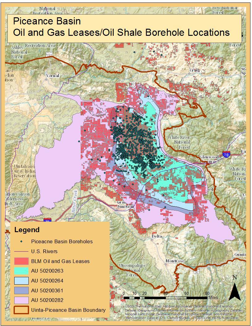
5 Site Selection Process Site Selection Criteria: Active or potential development Ecosystem services/trade-offs of interest Collocated Public land Available data Potential Decisions (BLM decision process) Candidate Sites: Greater Green River Basin San Juan Basin Piceance Basin Bakken Shale Formation Uranium Time-Out Area Site: Piceance Basin selected Site approved by USGS Director 5
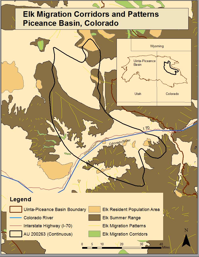
 Ecological Assessment Unit EAU Geographic boundaries, surface and subsurface components Clearly identifiable/measurable ecosystem services Possible Study Site EAUs Habitat Fragmentation Water")
6 Resource Assessment Units- RAU Reserves available under current economics conditions, for production of energy and mineral Areal unit for estimation of natural resources Study Site RAU Tight Gas (Sand) Ecological Assessment Unit EAU Geographic boundaries, surface and subsurface components Clearly identifiable/measurable ecosystem services Possible Study Site EAUs Habitat Fragmentation Water Quality Large Fauna (Elk) 6
7 7
8 Overview of Decision Support Tool What will our Decision Support Tool (DST) (i.e. our conceptual framework) do? Incorporate biology, ecology, geology, hydrology, economics, and engineering Integrates natural resource / economics value concepts, methods, and data Couples models and scientific data with market and nonmarket prices A Decision Support Tool: Estimates the net societal benefits of all natural resources developed and preserved Apply at multiple scales (large and within a region) Temporal Can operate in multiple regulatory constraint frameworks 8
9 DST: Informed Resource Development Net Societal Benefit Environmental Impact Development Costs Natural Gas Production Pads/Wells/Stimulation The Decision Support Tool: Systems are modeled as a network of stocks and flows Feedbacks are key between the various stocks and flows comprising the system Temporally dynamic (e.g. annual time step) and spatially aggregated (e.g. regional scale) 9

10 Yellow Data source is yet to be determined Orange No function assigned as of yet
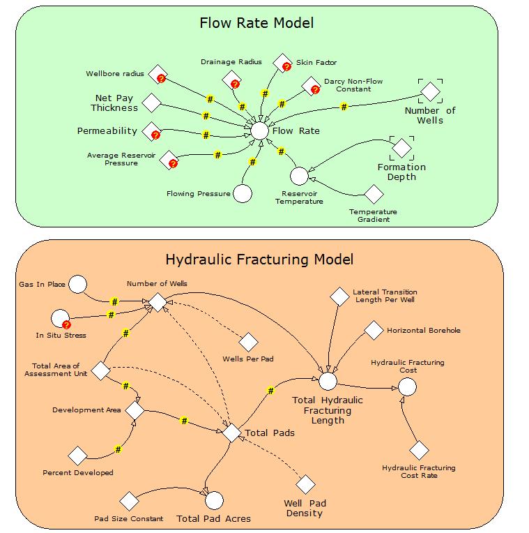
11 Hydraulic Fracturing Sub-models

12

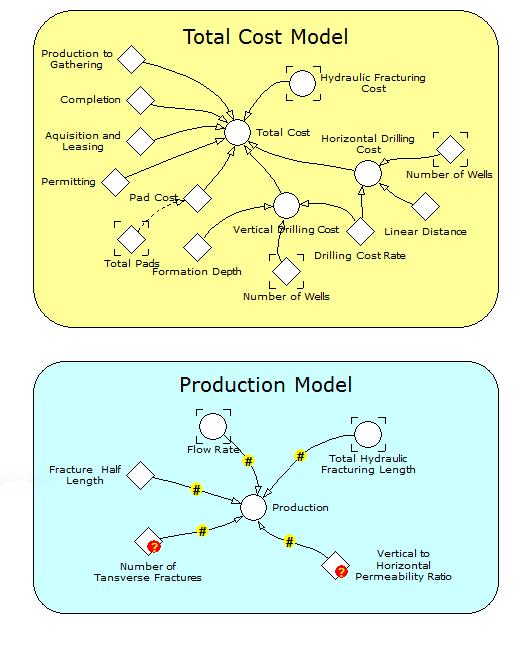
13 NetRA Flow Diagram RAU Quantity of Fuel Mineral Reserves Price Resources Extracted Reserves Ecosystem Change Fuel Resource Social Benefits EAU Water quality Total Social Benefits from RAU and EAU Quantity of Environment Price Habitat Fragmentation Environmental Social Benefits 13

14 Status and Next Step Proof of concept: Realization of a certain method or idea to demonstrate its feasibility who s purpose is to verify that some concept has the potential of being used Inputs: Data resolution, map scales, and model compatibility will be evaluated Data and model gaps will be identified Earth science for natural resource stocks, engineering economics, biophysical and ecological data for ecosystem services stocks, market prices, regulations, and nonmarket values Output: A limited modeling framework that demonstrates the functionality of the DST Example: Stepping backwards to make a leap forward Model of oil and gas drill pads and resource roads overlying National Aerial Imagery Program (NAIP) imagery, near Rifle, Colorado, 2007 (USGS sir )


15 Thank You Meeting Ecosystem Needs Meeting Development Needs Terrestrial Ecosystem Tight Gas Resources Ft Huachuca Mining NetRA: Integrated Science, Economics & Policy to find a Balance 15
Drilling & Developing the Marcellus Shale
 Drilling & Developing the Marcellus Shale Presented by the Independent Oil and Gas Association of Pennsylvania at the Pennsylvania State Association of Township Supervisors Annual Meeting, May 12, 2008,
WELCOME & INTRODUCTION
 MPA Management Capacity Building Training Module 1: WELCOME & INTRODUCTION Participants Distinguished Guests Welcome Site Overviews of MPAs represented Overview of Training Program What are Today s Objectives?
SPLAN-Natura Towards an integrated spatial planning approach for Natura th January, 2017 Brussels. Commissioned by DG Environment
 SPLAN-Natura 2000 Towards an integrated spatial planning approach for Natura 2000 Commissioned by DG Environment 17 th January, 2017 Brussels V. Simeonova (Ph.D.) Drivers towards integrating Biodiversity
Overview of Methods. Terrestrial areas that are most important for conservation Conservation
 Overview of Methods The goal of the Western Lake Erie Coastal Conservation Vision project (WLECCV) is to define where we should be working locally to optimally achieve regional conservation impact. The
Cooperating Organization Report of Circum Pacific Council for Energy and Mineral Resources (CPC)
") CCOP-41AS/6.2-29 Coordinating Committee for Geoscience Programmes in East and Southeast Asia (CCOP) 41 st CCOP Annual Session 15 18 November 2004 Tsukuba, Japan Cooperating Organization Report of Circum
CCOP-41AS/6.2-29 Coordinating Committee for Geoscience Programmes in East and Southeast Asia (CCOP) 41 st CCOP Annual Session 15 18 November 2004 Tsukuba, Japan Cooperating Organization Report of Circum
Marine Spatial Planning Leslie-Ann McGee Battelle Memorial Institute
 Marine Spatial Planning Leslie-Ann McGee Battelle Memorial Institute Rev061708 1 Marine Spatial Planning What is it? Why is it different? Where is it currently being employed? What is happening in the
An Introduction to Day Two. Linking Conservation and Transportation Planning Lakewood, Colorado August 15-16, 16, 2006
 An Introduction to Day Two Linking Conservation and Transportation Planning Lakewood, Colorado August 15-16, 16, 2006 1 Agenda Day One Transportation Planning Heritage Program State Wildlife Action Plan
Spatial Data Availability Energizes Florida s Citizens
 NASCIO 2016 Recognition Awards Nomination Spatial Data Availability Energizes Florida s Citizens State of Florida Agency for State Technology & Department of Environmental Protection Category: ICT Innovations
Land Use in the context of sustainable, smart and inclusive growth
 Land Use in the context of sustainable, smart and inclusive growth François Salgé Ministry of sustainable development France facilitator EUROGI vice president AFIGéO board member 1 Introduction e-content+
Social Values for Ecosystem Services (SolVES)
") Social Values for Ecosystem Services (SolVES) Presented to the Chesapeake Bay Program Scientific, Technical Assessment and Reporting (STAR) Team Meeting Annapolis, Maryland November 5, 2012 US Department
Social Values for Ecosystem Services (SolVES) Presented to the Chesapeake Bay Program Scientific, Technical Assessment and Reporting (STAR) Team Meeting Annapolis, Maryland November 5, 2012 US Department
Economic Benefit Study on Value of Spatial Information Australian Experience
 Economic Benefit Study on Value of Spatial Information Australian Experience Dr Zaffar Sadiq Mohamed-Ghouse Director, International Relations Cooperative Research Centre for Spatial Information zsadiq@crcsi.com.au
Mapping and Assessment of Ecosystems and their Services
 Mapping and Assessment of Ecosystems and their Services ALTER-Net Conference 2013: Science underpinning the EU 2020 Biodiversity Strategy. April 2013 Gent Joachim MAES 1 This presentation is based on the
Fig 1. Steps in the EcoValue Project
 Assessing the Social and Economic Value of Ecosystem Services in the Northern Forest Region: A Geographic Information System (GIS) Approach to Landscape Valuation Principal Investigator(s): Dr. Matthew
Application of GIS Technology in Watershed-based Management and Decision Making
 Application of GIS Technology in Watershed-based Management and Decision Making U. Sunday Tim Iowa State University Department of Agricultural and Biosystems Engineering 100 Davidson Hall Email:
Atlas of the Upper Gila River Watershed
 Atlas of the Upper Gila River Watershed Katie Banister, David Chan, Jessica M. Driscoll, Christopher Fullerton, Aaron Lien and Kelly Mott Lacroix January 2014 The University of Arizona Water Resources
USGS National Geospatial Program Understanding User Needs. Dick Vraga National Map Liaison for Federal Agencies July 2015
 + USGS National Geospatial Program Understanding User Needs Dick Vraga National Map Liaison for Federal Agencies July 2015 + Topics 2 Background Communities of Use User Surveys National Map Liaisons Partnerships
A Comprehensive Inventory of the Number of Modified Stream Channels in the State of Minnesota. Data, Information and Knowledge Management.
 A Comprehensive Inventory of the Number of Modified Stream Channels in the State of Minnesota Data, Information and Knowledge Management Glenn Skuta Environmental Analysis and Outcomes Division Minnesota
Marine/Maritime Spatial Planning Andrej Abramić
 Marine/Maritime Spatial Planning Andrej Abramić EcoAqua SUMMER SCHOOL: Ecosystem approach to aquaculture 26-29th of October 2015 Research and Technology to enhance excellence in Aquaculture development
New Frameworks for Urban Sustainability Assessments: Linking Complexity, Information and Policy
 New Frameworks for Urban Sustainability Assessments: Linking Complexity, Information and Policy Moira L. Zellner 1, Thomas L. Theis 2 1 University of Illinois at Chicago, Urban Planning and Policy Program
COMMON CONCEPTUAL AND OPERATIONAL FRAMEWORKS FOR RESEARCH AND SUSTAINABLE MANAGEMENT OF NESTED SOCIO-ECOLOGICAL SYSTEMS ACROSS LARGE WATERSHEDS
 COMMON CONCEPTUAL AND OPERATIONAL FRAMEWORKS FOR RESEARCH AND SUSTAINABLE MANAGEMENT OF NESTED SOCIO-ECOLOGICAL SYSTEMS ACROSS LARGE WATERSHEDS Angheluta VADINEANU 1 & Nusret KARAKAYA 2 1 Department of
Ecological Valuation for Land Use Planning Decision Support in South Florida: The Ecosystem Portfolio Model
 Ecological Valuation for Land Use Planning Decision Support in South Florida: The Ecosystem Portfolio Model Bill Labiosa, Rich Bernknopf, Paul Hearn, Dianna Hogan, Dave Strong, Leonard Pearlstine, Amy
Hydraulic Impacts of Limestone Quarries and Gravel Pits. Jeff Green Minnesota DNR-Division of Ecological & Water Resources
 Hydraulic Impacts of Limestone Quarries and Gravel Pits Jeff Green Minnesota DNR-Division of Ecological & Water Resources The Hydraulic Impacts of Limestone Quarries and Gravel Pits Study was funded by
Unconventional Oil Plays Opportunity vs Risk
 Unconventional Oil Plays Opportunity vs Risk EnerCom s London Oil & Gas Conference 4 June 14, 2012 Sofitel London Danny D. Simmons 1000 BOPD - What a great well! 10,000 1,000 BOPD 100 10 12/2009 1/2010
Assessing state-wide biodiversity in the Florida Gap analysis project
 University of Nebraska - Lincoln DigitalCommons@University of Nebraska - Lincoln Nebraska Cooperative Fish & Wildlife Research Unit -- Staff Publications Nebraska Cooperative Fish & Wildlife Research Unit
GIS Solutions in Natural Resource Management: Balancing the Technical- Political Equation
 GIS Solutions in Natural Resource Management: Balancing the Technical- Political Equation Stan Morain, Editor SUB Gdttlngen 7 208 520 309 98 A14447 0NW0RD PRESS V? % \
Biodiversity Blueprint Overview
 Biodiversity Blueprint Overview Climate Variability Climate projections for the Glenelg Hopkins Regions suggest that the weather will be hotter and drier in the coming years which will impact on land use,
Global Land Project: major scientific questions for coupled modelling
 Global Land Project: major scientific questions for coupled modelling Richard Aspinall Macaulay Land Use Research Institute and GLP Nodal Office on Integration and Modelling Aberdeen, Scotland NATO Advanced
U.S. Department of the Interior U.S. Geological Survey. Krista Karstensen Mark Drummond
 USGS Land-Cover Trends: A focus on contemporary land-use and land-cover change within the LCCs U.S. Department of the Interior U.S. Geological Survey Krista Karstensen Mark Drummond The Challenge Land
EcoServ-GIS. EcoServ GIS Stage I. Why EcoServ GIS? 17/12/2012
 EcoServ-GIS Ecosystem Services Mapping: A Wildlife Trust GIS Toolkit to map ecosystem services at a county scale Dr Jonathan Winn Living Landscape Coordinator Durham Wildlife Trust Dr Chloe Bellamy Ecosystem
Marine Spatial Planning: A Tool for Implementing Ecosystem-Based Management
 Marine Spatial Planning: A Tool for Implementing Ecosystem-Based Management Steven Murawski, Ph.D., Ecosystem Goal Team Lead National Oceanic and Atmospheric Administration NOAA November 16, 2009 1 To
Vegetation and Wildlife Habitat Mapping Study in the Upper and Middle Susitna Basin Study Plan Section 11.5
 (FERC No. 14241) Vegetation and Wildlife Habitat Mapping Study in the Upper and Middle Susitna Basin Study Plan Section 11.5 Initial Study Report Part C: Executive Summary and Section 7 Prepared for Prepared
Mineral reserves and resources
 Mineral reserves and resources Our mineral reserves and resources are the foundation of our company and fundamental to our success. We have interests in a number of uranium properties. The tables in this
Outline National legislative & policy context Regional history with ESSIM ESSIM Evaluation Phase Government Integration via RCCOM Regional ICOM Framew
 What MSP Implementation could change in the Maritimes Region Tim Hall, Regional Manager Oceans and Coastal Management Division Ecosystem Management Branch Fisheries and Oceans Canada Maritimes Region BIO
Alluvium Consulting Australia Senior integrated water management specialist Position Description March 2018
 Alluvium Consulting Australia Senior integrated water management specialist Position Description March 2018 Overview of Alluvium We are an employee-owned consulting firm founded in 2006 to provide advice
Assessment and valuation of Ecosystem Services for decision-makers
 Assessment and valuation of Ecosystem Services for decision-makers An introduction to the ARIES approach Ferdinando Villa *, Ken Bagstad Gary Johnson, Marta Ceroni *Basque Center for Climate Change, Bilbao,
Landscape Analysis of Mineral Resources A View from Home Tree ( Avatar )
") NRC Workshop on Landscape Approaches and Multi-Resource Analysis for Sustainable Natural Resource Management: June 2, 2015 Landscape Analysis of Mineral Resources A View from Home Tree ( Avatar ) Murray
NRC Workshop on Landscape Approaches and Multi-Resource Analysis for Sustainable Natural Resource Management: June 2, 2015 Landscape Analysis of Mineral Resources A View from Home Tree ( Avatar ) Murray
Application for Geotourism Charter
 Application for Geotourism Charter Thank you for the interest in geotourism as a long-term strategy to foster wisely managed tourism and enlightened destination stewardship. National Geographic s Center
EBA Engineering Consultants Ltd. Creating and Delivering Better Solutions
 EBA Engineering Consultants Ltd. Creating and Delivering Better Solutions ENHANCING THE CAPABILITY OF ECOSYSTEM MAPPING TO SUPPORT ADAPTIVE FOREST MANAGEMENT Prepared by: EBA ENGINEERING CONSULTANTS LTD.
Land Accounts - The Canadian Experience
 Land Accounts - The Canadian Experience Development of a Geospatial database to measure the effect of human activity on the environment Who is doing Land Accounts Statistics Canada (national) Component
Marine Spatial Planning (MSP): A practical approach to ecosystembased
: A practical approach to ecosystembased") Marine Spatial Planning (MSP): A practical approach to ecosystembased management Erik Olsen, Institute of Marine Research, Norway Fanny Douvere, International Oceanographic Commission Overview Why we need
Marine Spatial Planning (MSP): A practical approach to ecosystembased management Erik Olsen, Institute of Marine Research, Norway Fanny Douvere, International Oceanographic Commission Overview Why we need
An Introduction to NatureServe Linking Conservation and Transportation Planning Phoenix, Arizona November 8 & 9, 2006
 An Introduction to NatureServe Linking Conservation and Transportation Planning Phoenix, Arizona November 8 & 9, 2006 1 NatureServe in Brief An independent, non-profit conservation organization Provides
INSPIRE Basics. Vlado Cetl European Commission Joint Research Centre. https://ec.europa.eu/jrc/
 INSPIRE Basics Vlado Cetl European Commission Joint Research Centre https://ec.europa.eu/jrc/ Serving society Stimulating innovation Supporting legislation Outline SDI? Why European SDI? INSPIRE Policy
5. Environmental Analysis
 5.9 MINERAL RESOURCES 5.9.1 Methodology The California Geological Survey Mineral Resources Project provides information about California s nonfuel mineral resources. The primary focus of the Mineral Resources
Progress on Defense-Related Uranium Mines Program
 Progress on Defense-Related Uranium Mines Program Russel Edge US Department of Energy (DOE) Office of Legacy Management (LM) John Elmer Navarro Research and Engineering, Inc., Contractor to LM Uranium
Quantifying and Valuing Floodplain Nutrient and Sediment Retention
 Quantifying and Valuing Floodplain Nutrient and Sediment Retention Krissy Hopkins, Dianna Hogan, Emily Pindilli, Greg Noe, Fabiano Franco, and Stephanie Gordon A Community on Ecosystem Services December
Geospatial Policy Development and Institutional Arrangements *
 HIGH LEVEL FORUM ON GLOBAL GEOSPATIAL MANAGEMENT INFORMATION WORKING PAPER No. 13 First Forum Seoul, Republic of Korea, 24-26 October 2011 Geospatial Policy Development and Institutional Arrangements *
What is a compact city? How could it be measured?
 What is a compact city? How could it be measured? Madhu Singh Transport Planner Directorate of Urban Land Transport, Bangalore Guided By: Professor H. M. Shivanand Swamy CEPT University, Ahmedabad Cities
Geology and the Aggregate Industry: The Role of Geologists
 Geology and the Aggregate Industry: The Role of Geologists Donald G. Mikulic Illinois State Geological Survey Prairie Research Institute University of Illinois at Urbana-Champaign Outline Importance of
Possibilities for applying ES assessment results in spatial planning in Latvia
 Possibilities for applying ES assessment results in spatial planning in Latvia Inga Hoņavko LIFE EcosystemServices project manager LIFE Viva Grass seminar, Sigulda, 17.05.2018 Projekts LIFE EcosystemServices,
Phase 1 Geoscientific Preliminary Assessment Southern Ontario, Sedimentary Communities
 Phase 1 Geoscientific Preliminary Assessment Southern Ontario, Sedimentary Communities Presented to: Community Liaison Committees (Brockton, Huron-Kinloss, South Bruce) March 2014 Project Description»
Mineral reserves and resources
 Mineral reserves and resources Our mineral reserves and resources are the foundation of our company and fundamental to our success. We have interests in a number of uranium properties. The tables in this
DWH Restoration Funding at a Glance
 NCER 2018 DWH Restoration Funding at a Glance Natural Resource Damage Assessment: $8.1 Billion RESTORE Act: $5.3 Billion National Fish and Wildlife Foundation GEBF: $2.5 Billion National Academy of Sciences:
Policy-oriented ES-research in Belgium: progress and prospects
 Policy-oriented ES-research in Belgium: progress and prospects Vilm 12.10.2011 Sander Jacobs 1, Wouter Van Reeth², Jan Staes 1 & Patrick Meire 1 1 University of Antwerp, ecosystem management research group
UNSD SEEA-EEA revision 2020
 UNSD SEEA-EEA revision 2020 Area 1: Spatial units; introduction Sjoerd Schenau, Patrick Bogaart, Edwin Horlings London group meeting, October 2018 Overview Spatial units in SEEA EEA Main revision issues
Arctic ecosystem services: TEEB Arctic Scoping study. Alexander Shestakov WWF Global Arctic Programme 3 December Arctic Biodiversity Congress
 Arctic ecosystem services: TEEB Arctic Scoping study Alexander Shestakov WWF Global Arctic Programme 3 December 20143 Arctic Biodiversity Congress Content 1. Project design 2. Approach 3. Challenges and
WHAT IS MINERAL EXPLORATION?
 INDABA PRESENTATION CAPE TOWN FEBRUARY 2017 AIM:SAV WHAT IS MINERAL EXPLORATION? AIM:SAV What is mineral exploration? 2 Exploration is the term used to describe a wide range of activities aimed at searching
Accounting for Ecosystem and Biodiversity Related Themes in Uganda
 Introduction Accounting for Ecosystem and Biodiversity Related Themes in Uganda Calls for more evidence-based approaches to policy have increased the need for integrated environmental-economic information
Terms of Reference for the Comparative Environmental Review (CER) of. Options for the Mactaquac Project, Mactaquac, New Brunswick
 of. Options for the Mactaquac Project, Mactaquac, New Brunswick") Terms of Reference for the Comparative Environmental Review (CER) of Options for the Mactaquac Project, Mactaquac, New Brunswick Preamble The New Brunswick Power Corporation ( NB Power ) operates the Mactaquac
Terms of Reference for the Comparative Environmental Review (CER) of Options for the Mactaquac Project, Mactaquac, New Brunswick Preamble The New Brunswick Power Corporation ( NB Power ) operates the Mactaquac
Assessing Investment in Future Landsat Instruments for Ecosystem Management: The Example of Forest Carbon Sequestration
 Assessing Investment in Future Landsat Instruments for Ecosystem Management: The Example of Forest Carbon Sequestration Molly K. Macauley Jhih-Shyang Shih ACES 2010 7 December 2010 macauley@rff.org;shih@rff.org
Mineral reserves and resources
 Mineral reserves and resources Our mineral reserves and resources are the foundation of our company and fundamental to our success. We have interests in a number of uranium properties. The tables in this
GRINDING THE GEARS AND PUTTING THE RUBBER TO THE ROAD GEOSCIENCE AUSTRALIA S EXPERIENCE IN IMPLEMENTING THE FOUNDATION SPATIAL DATA FRAMEWORK
 GRINDING THE GEARS AND PUTTING THE RUBBER TO THE ROAD GEOSCIENCE AUSTRALIA S EXPERIENCE IN IMPLEMENTING THE FOUNDATION SPATIAL DATA FRAMEWORK Shane Crossman Geoscience Australia Shane.Crossman@ga.gov.au
Subcommittee on Sedimentation Draft Sediment Analysis Guidelines for Dam Removal
 Subcommittee on Sedimentation Draft Sediment Analysis Guidelines for Dam Removal August 4, 2011 Jennifer Bountry, M.S., P.E. Tim Randle, M.S., P.E., D.WRE. Blair Greimann, Ph.D., P.E. Sedimentation and
Landscape Planning and Habitat Metrics
 Landscape Planning and Habitat Metrics Frank W. Davis National Center for Ecological Analysis and Synthesis UC Santa Barbara (Tools for Landscape Biodiversity Planning) Jimmy Kagan Institute for Natural
Spatial units (Levels 0 and 1)
") Spatial units (Levels 0 and 1) Project: Advancing the SEEA Experimental Ecosystem Accounting Overview: Spatial units 1. Learning objectives 2. Level 1: Presentation & group exercise Spatial units (10m
Spatial units (Levels 0 and 1) Project: Advancing the SEEA Experimental Ecosystem Accounting Overview: Spatial units 1. Learning objectives 2. Level 1: Presentation & group exercise Spatial units (10m
06/04/2015. Overview: Spatial units. Advancing the SEEA Experimental Ecosystem Accounting Spatial units (Level 1)
") Advancing the SEEA Experimental Ecosystem Accounting Spatial units (Level 1) Advancing the SEEA-EEA Project Overview: Spatial units 1. Learning objectives 2. Level 1: Presentation & group exercise Spatial
Advancing the SEEA Experimental Ecosystem Accounting Spatial units (Level 1) Advancing the SEEA-EEA Project Overview: Spatial units 1. Learning objectives 2. Level 1: Presentation & group exercise Spatial
This year s conference theme: Mining Geology through the value chain
 Benchmarking: Does it have a role in improving the performance of mining geology? AMC Consultants Pty Ltd Mark Berry, Principal Geologist This year s conference theme: Mining Geology through the value
1 Complementary Access Tools
 ENERGY IHS AccuMap Shaped by industry and powered by IHS Markit information, AccuMap is a powerful and intuitive interpretation solution for the Canadian Energy Industry. 1 Complementary Access Tools AccuLogs
Sustainability science
 Sustainability science and the challenges of transdisciplinary research Sustainability science and the challenges of transdisciplinary research Responding to the challenges of SD Sustainable development
Coastal Viewer Mapping Application:
 Coastal Viewer Mapping Application: MAPPING OF COASTAL PUBLIC PROPERTY, THE COASTAL PROTECTION ZONE BOUNDARIES AND AUDITING OF STRUCTURES ON THE COASTAL PUBLIC PROPERTY 15 May 2014 INTEGRATED COASTAL MANAGEMENT
Resolution XIII.23. Wetlands in the Arctic and sub-arctic
 13th Meeting of the Conference of the Contracting Parties to the Ramsar Convention on Wetlands Wetlands for a Sustainable Urban Future Dubai, United Arab Emirates, 21-29 October 2018 Resolution XIII.23
Overview of Geoscience Employers Workshop Outcomes
 Overview of Geoscience Employers Workshop Outcomes General thoughts on concepts: From Geoscience Employers Workshop Systems Thinking How systems work and interact Processes Atmosphere: Climate, Weather,
Licensed Science Officer Benchmark
 POSITION EVALUATION RATIONALE POSITION TITLE MINISTRY AND DIVISION Energy, Mines and Petroleum Resources: Geology Division BRANCH AND SECTION Mineral Resources Branch, Applied Geology Section UNIT OR PROGRAM
COAL BED NATURAL GAS BASINS AND PRODUCED WATER
 COAL BED NATURAL GAS BASINS AND PRODUCED WATER Presented To Garfield County Energy Advisory Board February 3, 2005 Presented By - Doug Dennison, Oil & Gas Liaison Outline Goal of Presentation What is CBNG?
GOVERNMENT MAPPING WORKSHOP RECOVER Edmonton s Urban Wellness Plan Mapping Workshop December 4, 2017
 GOVERNMENT MAPPING WORKSHOP 12.4.17 RECOVER Edmonton s Urban Wellness Plan Mapping Workshop December 4, 2017 In July of 2017, City Council directed administration to develop RECOVER, Edmonton s Urban Wellness
The first steps in the hydropower project cycle:
 The first steps in the hydropower project cycle: Initial investigations and feasibility studies 12 September 2013 Bruce Taylor Introduction Objectives of early stage studies Tools and methods Case study
Unconventional Reservoir Development: The Role of Geoscience from a State Regulator s Perspective
 Unconventional Reservoir Development: The Role of Geoscience from a State Regulator s Perspective Nick Tew Alabama State Geologist and Oil and Gas Supervisor President, American Geosciences Institute Geological
The Role of the Geoscientist in the U.S. Federal Government*
 The Role of the Geoscientist in the U.S. Federal Government* Brenda Pierce 1 Search and Discovery Article #120006 (2009) Posted November 20, 2009 *Adapted from presentation at AAPG Geoscience Technology
PROPOSED UNESCO FUNDY BIOSPHERE RESERVE
 OVERVIEW PROPOSED UNESCO FUNDY BIOSPHERE RESERVE NEW BRUNSWICK, CANADA NOMINATION DOCUMENT April 10, 2007 The United Nations Educational, Scientific and Cultural Organization (UNESCO) Man and the Biosphere
Technical Drafting, Geographic Information Systems and Computer- Based Cartography
 Technical Drafting, Geographic Information Systems and Computer- Based Cartography Project-Specific and Regional Resource Mapping Services Geographic Information Systems - Spatial Analysis Terrestrial
Economic Geology Unconventional Energy Research
 Bureau of Economic Geology Unconventional Energy Research Overview for CEE meeting December, 2011 QAd2349x BUREAU OF ECONOMIC GEOLOGY Oldest research unit of The University of Texas at Austin Geological
Hydrologic Analysis for Ecosystem Restoration
 Hydrologic Analysis for Ecosystem Restoration Davis, California Objectives: To provide participants with: 1) an understanding of the issues in restoration studies; 2) an overview of Corps policies and
Implementation of the Political Declaration on energy cooperation between the North Seas Countries. Support Group 1 on Maritime Spatial Planning
 Implementation of the Political Declaration on energy cooperation between the North Seas Countries Support Group 1 on Maritime Spatial Planning Work Programme 1. Work area as outlined in Annex I to the
EnviroAtlas: An Atlas about Ecosystems and their Connection with People
 EnviroAtlas: An Atlas about Ecosystems and their Connection with People Annie Neale, Megan Mehaffey & Atlas Team ASWM Webinar October, 17 th, 2012 What is it? The Atlas is an online decision support tool
Opportunities to Improve Ecological Functions of Floodplains and Reduce Flood Risk along Major Rivers in the Puget Sound Basin
 Opportunities to Improve Ecological Functions of Floodplains and Reduce Flood Risk along Major Rivers in the Puget Sound Basin Christopher Konrad, US Geological Survey Tim Beechie, NOAA Fisheries Managing
Sustainable management of sediment resources: sediment management at the river basin scale
 Sustainable management of sediment resources: sediment management at the river basin scale Phil Owens University of Northern British Columbia, Canada owensp@unbc.ca Co-authos: Sabine Apitz, Ramon Batalla,
Cross-border Maritime Spatial Plan for the Black sea - Romania and Bulgaria project
 Cross-border Maritime Spatial Plan for the Black sea - Romania and Bulgaria project in Romania and Bulgaria Plan Presentation A first step in the management of the marine areas of Romania and Bulgaria
16540/14 EE/cm 1 DG E 1A
 Council of the European Union Brussels, 5 December 2014 (OR. en) 16540/14 ENV 965 CULT 139 NOTE From: To: Subject: General Secretariat of the Council Delegations Charter of Rome on Natural and Cultural
Role of SF-MST. A summary of SF-MST
 A summary of SF-MST UNWTO Committee on Statistics and TSA Madrid, 27 & 28 February 2018 Carl Obst, IDEEA Group Consultant to UNWTO Role of SF-MST Respond to the significant demand for robust measures of
Thoughts toward autonomous land development. Introduction
 Thoughts toward autonomous land development Spatial Transformation of Regular grid Irrigation Frameworks Bangkok and Cairo A Work in Progress Information based on student workshop June 2009 and earlier
Kyoto and Carbon Initiative - the Ramsar / Wetlands International perspective
 Kyoto and Carbon Initiative - the Ramsar / Wetlands International perspective (the thoughts of Max Finlayson, as interpreted by John Lowry) Broad Requirements Guideline(s) for delineating wetlands (specifically,
Marine Spatial Planning as an important tool for implementing the MSFD
 Marine Spatial Planning as an important tool for implementing the MSFD Risto Kalliola Tallinn, Nov. 16 th 2012 DEPARTMENT OF GEOGRAPHY AND GEOLOGY University of Turku, Finland Ten principles to provide
Natura 2000 and spatial planning. Executive summary
 Natura 2000 and spatial planning Executive summary DISCLAIMER The information and views set out in this study are those of the author(s) and do not necessarily reflect the official opinion of the Commission.
Unmanned Aircraft Systems (UAS) Activities in Earth Sciences
 Activities in Earth Sciences") Unmanned Aircraft Systems (UAS) Activities in Earth Sciences Bruce K. Quirk quirk@usgs.gov Department of the Interior U.S. Geological Survey June 22, 2015 Department of the Interior Bureau of Land Management
Unmanned Aircraft Systems (UAS) Activities in Earth Sciences Bruce K. Quirk quirk@usgs.gov Department of the Interior U.S. Geological Survey June 22, 2015 Department of the Interior Bureau of Land Management
Economic and Social Council
 United Nations Economic and Social Council Distr.: General 18 July 2016 Original: English Committee of Experts on Global Geospatial Information Management Sixth session New York, 3-5 August 2016 Item 2
National Perspectives - Portugal. Margarida Almodovar
 National Perspectives - Portugal Margarida Almodovar margarida.almodovar@mam.gov.pt from base line to the external limit of the continental shelf behind 200 miles and according to UNCLOS definitions Economic
DEPARTMENT OF GEOLOGY AND MINERAL INDUSTRIES WAYS & MEANS SUBCOMMITTEE ON NATURAL RESOURCES MARCH 2, 2017
 DEPARTMENT OF GEOLOGY AND MINERAL INDUSTRIES WAYS & MEANS SUBCOMMITTEE ON NATURAL RESOURCES MARCH 2, 2017 1 ABOUT DOGAMI AGENCY MISSION, VISION & GOALS 2 Lidar image of a stream network along the Umpqua
Improvement of the National Hydrography Dataset for Parts of the Lower Colorado Region and Additional Areas of Importance to the DLCC
 Improvement of the National Hydrography Dataset for Parts of the Lower Colorado Region and Additional Areas of Importance to the DLCC Carlos Reyes-Andrade California State University, Northridge September
Integrated valuation of biodiversity and ecosystem services
 Integrated valuation of biodiversity and ecosystem services The challenge of articulating social, ecological and economic values in ecosystem services science and policy Integrated valuation What, Why
Biodiversity and Protected Areas Management Project
 Biodiversity and Protected Areas Management Project Technical Advisor ESA region: Selwyn Willoughby Coordinator ESA region: Christine Mentzel FlexiCadastre EMEA Regional User Conference, Cape Town, South
Key Indicators for Territorial Cohesion & Spatial Planning Stakeholder Workshop - Project Update. 13 th December 2012 San Sebastián, Basque Country
 Key Indicators for Territorial Cohesion & Spatial Planning Stakeholder Workshop - Project Update 13 th December 2012 San Sebastián, Basque Country Key Aims Explore the use of territorial data in developing