Stream Ecological Assessment in Virginia Using INSTAR. Greg Garman Leonard Smock Stephen McIninch William Shuart Virginia Commonwealth University
|
|
|
- Reynold Hunter
- 6 years ago
- Views:
Transcription
1 Stream Ecological Assessment in Virginia Using INSTAR Greg Garman Leonard Smock Stephen McIninch William Shuart Virginia Commonwealth University
2 Interactive Stream Assessment Resource (INSTAR( INSTAR) Program Goals Develop a comprehensive stream and river database and use it to conduct interactive and objective, geospatial assessments of lotic ecosystem health and function Develop a novel decision-support support tool that leverages an extensive new stream and river database with state- of-the the-art information technologies
3 INSTAR at a glance The Database Aquatic resources and in-stream habitat information >200K records representing >1,825 stream reaches (probabilistic design) Ecological models (i.e., virtual reference streams) to support objective assessment and analysis of stream health The Application Interactive and internet based (ArcIMS( ArcIMS; ; MS SQL) High-resolution spatial data (GIS) coverages Wide range of functions and database queries supported; new lite interface in beta testing Accessible to anyone with a PC and modem
4 INSTAR Supports Two BioAssessment Protocols: Modified Index of Biotic Integrity (mibi) Metrics: 1. Native species richness 2. Number of R, T, & E species 3. Number of non-indigenous species 4. Number of significant species 5. Number of tolerant species 6. Number of intolerant species -Regional Scoring Criteria -Index ranges between Broad geospatial scales (e.g. 6 th order watersheds) -Qualitative data are inputs Virtual Stream Assessment (VSA) Percent comparability to virtual regional reference conditions Empirical ranges: 12-88% of VSA models Statistics supported multiple VSA models, including lower piedmont, coastal plain, and Shenandoah basin Intermediate and fine spatial scales (stream reach) Quantitative data are inputs
5
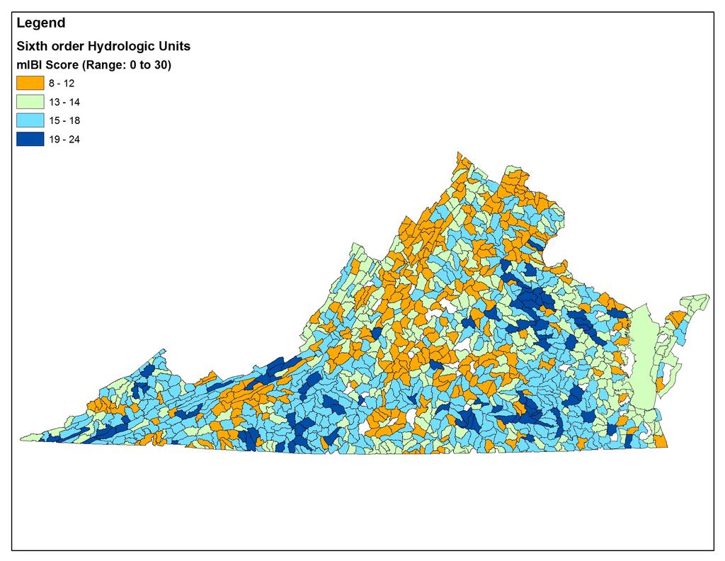
6 INSTAR Supports Two Bioassessment Protocols: Modified Index of Biotic Integrity (mibi) Metrics: 1. Native species richness 2. Number of R, T, & E species 3. Number of non-indigenous species 4. Number of critical species 5. Number of tolerant species 6. Number of intolerant species Regional Scoring Criteria Ranges between 6-30 Broad geospatial scales (HUCs) Virtual Stream Assessment (VSA) Percent comparability to virtual regional reference conditions Empirical range: 8-90% of VSA region-appropriate model Statistics currently support several regional VSA models, including lower piedmont and coastal zone; others in development (e.g. Shenandoah) Intermediate spatial scales (reach) Quantitative data are inputs
7 The INSTAR Database Biological 18 IBI metrics 12 RBP III metrics others Geomorphology 4 Rosgen-type classification metrics Candidate Input Variables for Virtual Stream Models In-stream Habitat 20 RHA metrics Landscape Stream order, link metrics, green infrastructure Modeling exercise to answer: Which of these ~63 stream attributes are most closely related to stream integrity, structure, and function?
8 Data Analysis Data Retrieval Graphically assess data for outliers Make necessary transformations Data Ordination; CCA Fish Data Macroinvertebrate Data Habitat Data Combined Data Set Model Creation (SMR) and Validation
 Chnalt = percent channel alteration Intol = percent intolerant species Toler = number tolerant species HBI =")
9 Virtual Stream Model Lower Coastal Plain Virtual Reference Stream (100%) = 0.05(EP) (Rich) (Chnlalt) - 0.1(Intol) (Toler) (HBI) EP = Ephemeroptera & Plecoptera taxa Rich = fish species richness (native) Chnalt = percent channel alteration Intol = percent intolerant species Toler = number tolerant species HBI = Hilsenhoff Biotic Index adjusted R square = 0.72

10
11 Stream Ecological Integrity Classes -1 sd Mean + 1 sd Poor Fair Good Excellent (i.e., Healthy) n=1,068
12
13


14
15 Selected INSTAR Applications: 1. Integrate Excellent/Extraordinary (i.e., healthy ) into Stream Conservation Units (VNH) 2. Expand mitigation credits (stream bank) for protection and conservation of healthy streams (TNC/DEQ/COE) 3. Target resource protection activities (TNC s freshwater portfolio) 4. Target development activities (UDAs; Coastal GEMS) 5. Enhance existing state programs and policies (NPS assessment; Shenandoah fish kills; Richmond County NFWF program; DEQ ProbMon program) 6. Healthy Waters Pilot Initiative in Virginia
Use of benthic invertebrate biological indicators in evaluating sediment deposition impairment on the Middle Truckee River, California
 Use of benthic invertebrate biological indicators in evaluating sediment deposition impairment on the Middle Truckee River, California David B. Herbst Sierra Nevada Aquatic Research Laboratory University
Monitoring and evaluation of benthic macroinvertebrates in the Big Hole River and tributaries
 Monitoring and evaluation of benthic macroinvertebrates in the Big Hole River and tributaries Michael A. Bias Big Hole River Foundation Introduction BMI used to evaluate stream biological health Quantifies
Savannah District s Revised SOP: Moving Towards A Functional Approach. US Army Corps of Engineers BUILDING STRONG
 Savannah District s Revised SOP: Moving Towards A Functional Approach US Army Corps of Engineers Agenda SOP Revision Concept New Aquatic Resource Credit Types New Urban Mitigation Service Area Filter Background
Birch Creek Geomorphic Assessment and Action Plan
 Birch Creek Geomorphic Assessment and Action Plan Jim Webster Tim Hanrahan, PhD, CFM Jesse Schwartz, PhD Zach Hill January 22, 2015 White Eagle Grange This Project is a First Step in Strategy Planning
Fish Passage and Abundance around Grade Control Structures on Incised Streams in Western Iowa
 Fish Passage and Abundance around Grade Control Structures on Incised Streams in Western Iowa John Thomas Hungry Canyons Alliance Mary Culler Iowa State University / Missouri DNR Dimitri Dermisis IIHR
Keanahalululu Gulch, Hawaiÿi
 DAR Watershed Code: 85021 WATERSHED FEATURES Keanahalululu Gulch watershed occurs on the island of Hawaiÿi. The Hawaiian meaning of the name is unknown. The area of the watershed is 4.1 square mi (10.6
POPULATION DEMOGRAPHICS IN DOG RIVER WATERSHED OVER TIME
 POPULATION DEMOGRAPHICS IN DOG RIVER WATERSHED OVER TIME Kal-El Q. Waters-Jones, Department of Earth Sciences, University of South Alabama, Mobile, AL 36688. E-mail: kwatersjones@yahoo.com. Over time,
Landscape Planning and Habitat Metrics
 Landscape Planning and Habitat Metrics Frank W. Davis National Center for Ecological Analysis and Synthesis UC Santa Barbara (Tools for Landscape Biodiversity Planning) Jimmy Kagan Institute for Natural
Hydrologic Analysis for Ecosystem Restoration
 Hydrologic Analysis for Ecosystem Restoration Davis, California Objectives: To provide participants with: 1) an understanding of the issues in restoration studies; 2) an overview of Corps policies and
The Refugia Concept: Using Watershed Analysis to Prioritize Salmonid Habitat for Conservation and Restoration
 The Refugia Concept: Using Watershed Analysis to Prioritize Salmonid Habitat for Conservation and Restoration Christopher May Battelle & UW Cumulative Impacts of Urbanization Landscape Alterations Loss
Puakea, Hawaiÿi. Puakea, Hawaiÿi WATERSHED FEATURES
 Puakea, Hawaiÿi DAR Watershed Code: 85046 Puakea, Hawaiÿi WATERSHED FEATURES Puakea watershed occurs on the island of Hawaiÿi. The Hawaiian meaning of the name is white blossom. The area of the watershed
Geospatial Decision Support Tools for Planning of Marine Protected Areas in California
 Geospatial Decision Support Tools for Planning of Marine Protected Areas in California WILL MCCLINTOCK (UNIVERSITY OF CALIFORNIA SANTA BARBARA), MATT MERRIFIELD (THE NATURE CONSERVANCY), SOPHIE DE BEUKELAER
WV WATERSHED ASSESSMENT PILOT PROJECT
 WV WATERSHED ASSESSMENT PILOT PROJECT Expert Workshop #1, Round 2 Bridgeport Conference Center, October 10 & 11, 2012 Gauley River Kent Mason Outline Project Background Methodology & Model Structure Relative
Fig 1. Steps in the EcoValue Project
 Assessing the Social and Economic Value of Ecosystem Services in the Northern Forest Region: A Geographic Information System (GIS) Approach to Landscape Valuation Principal Investigator(s): Dr. Matthew
Assessment and valuation of Ecosystem Services for decision-makers
 Assessment and valuation of Ecosystem Services for decision-makers An introduction to the ARIES approach Ferdinando Villa *, Ken Bagstad Gary Johnson, Marta Ceroni *Basque Center for Climate Change, Bilbao,
Effects to Communities & Ecosystems
 Biology 5868 Ecotoxicology Effects to Communities & Ecosystems April 18, 2007 Definitions Ecological Community an assemblage of populations living in a prescribed area or physical habitat [It is] the living
Juanita Bacey Environmental Scientist. Terrell Barry Research Scientist III. April 2008
 A Comparison Study of the Proper use of Hester-Dendy Samplers to Achieve Maximum Diversity and Population Size of Benthic Macroinvertebrates Sacramento Valley, California Juanita Bacey Environmental Scientist
Quantifying and Valuing Floodplain Nutrient and Sediment Retention
 Quantifying and Valuing Floodplain Nutrient and Sediment Retention Krissy Hopkins, Dianna Hogan, Emily Pindilli, Greg Noe, Fabiano Franco, and Stephanie Gordon A Community on Ecosystem Services December
Wailupe, Oÿahu. Wailupe, Oÿahu WATERSHED FEATURES
 DAR Watershed Code: 33005 WATERSHED FEATURES Wailupe watershed occurs on the island of Oÿahu. The Hawaiian meaning of the name is kite water. The area of the watershed is 3.4 square mi (8.8 square km),
Integrating Aquatic Insect Data Into Hawaiian Stream Assessments
 Integrating Aquatic Insect Data Into Hawaiian Stream Assessments DAN A. POLHEMUS Division of Aquatic Resources DLNR State of Hawaii Insects for the Future HAWAII Hawaiian Islands is an isolated hotspot
Ecological Land Cover Classification For a Natural Resources Inventory in the Kansas City Region, USA
 Ecological Land Cover Classification For a Natural Resources Inventory in the Kansas City Region, USA by Applied Ecological Services, Inc. In cooperation with the Mid-America Regional Council 600 Broadway,
Overview of Methods. Terrestrial areas that are most important for conservation Conservation
 Overview of Methods The goal of the Western Lake Erie Coastal Conservation Vision project (WLECCV) is to define where we should be working locally to optimally achieve regional conservation impact. The
Priority Conservation Area and Cumulative Resource Assessment Integration Methods
 Priority Conservation Area and Cumulative Resource Assessment Integration Methods Introduction and Background Habitat loss, fragmentation, and degradation represent the most significant threats to the
BZ471, Steam Biology & Ecology Exam
 BZ471, Eam1, p.1 BZ471, Steam Biology & Ecology Eam Name Multiple choice When benthic organisms enter the water column with a regular diel periodicity: a) catastrophic drift b) behavioral drift c) constant
Mapping the Distributions of the. America: Data and Tools
 Mapping the Distributions of the Freshwater Fishes of North America: Data and Tools Comparing Apples,Oranges and Pineapples: Mapping the distribution of brook trout; Lessons learned from the Eastern Brook
GIS Solutions in Natural Resource Management: Balancing the Technical- Political Equation
 GIS Solutions in Natural Resource Management: Balancing the Technical- Political Equation Stan Morain, Editor SUB Gdttlngen 7 208 520 309 98 A14447 0NW0RD PRESS V? % \
Using Big Interagency Databases to Identify Climate Refugia for Idaho s Species of Concern
 Using Big Interagency Databases to Identify Climate Refugia for Idaho s Species of Concern What is a Climate Refugia? habitat that supports a locally reproducing population [or key life history stage]
Modeling Fish Assemblages in Stream Networks Representation of Stream Network Introduction habitat attributes Criteria for Success
 Modeling Fish Assemblages in Stream Networks Joan P. Baker and Denis White Western Ecology Division National Health & Environmental Effects Research Laboratory U.S. Environmental Protection Agency baker.joan@epa.gov
SYSTEM WIDE WATER RESOURCES PROGRAM UNIFYING TECHNOLOGIES GEOSPATIAL APPLICATIONS (GIS IN SWWRP)
") SYSTEM WIDE WATER RESOURCES PROGRAM UNIFYING TECHNOLOGIES GEOSPATIAL APPLICATIONS (GIS IN SWWRP) 3 August 2005 2005 Tri-Service Infrastructure Systems Conference Re-Energizing Engineering Excellence The
SYSTEM WIDE WATER RESOURCES PROGRAM UNIFYING TECHNOLOGIES GEOSPATIAL APPLICATIONS (GIS IN SWWRP) 3 August 2005 2005 Tri-Service Infrastructure Systems Conference Re-Energizing Engineering Excellence The
The River Continuum Concept (or not?) Stream Classification
 Stream Classification") The River Continuum Concept (or not?) Stream Classification Goal: Generalization 2 general types of classification streams (longitudinal) streams (e.g., hydrologic regime classification) Longitudinal Classification
The River Continuum Concept (or not?) Stream Classification Goal: Generalization 2 general types of classification streams (longitudinal) streams (e.g., hydrologic regime classification) Longitudinal Classification
ILLINOIS RIVER BASIN RESTORATION COMPREHENSIVE PLAN WITH INTEGRATED ENVIRONMENTAL ASSESSMENT APPENDIX B
 ILLINOIS RIVER BASIN RESTORATION COMPREHENSIVE PLAN WITH INTEGRATED ENVIRONMENTAL ASSESSMENT APPENDIX B SYSTEM ECOLOGY ILLINOIS RIVER BASIN RESTORATION COMPREHENSIVE PLAN WITH INTEGRATED ENVIRONMENTAL
T he O utlet: Almirante
 T he O utlet: Almirante For me, the sea is life. This understanding also holds true with our rivers. Each are alive, and carry life with them as they reach the sea. Our rivers, are born up high in the
Opportunities to Improve Ecological Functions of Floodplains and Reduce Flood Risk along Major Rivers in the Puget Sound Basin
 Opportunities to Improve Ecological Functions of Floodplains and Reduce Flood Risk along Major Rivers in the Puget Sound Basin Christopher Konrad, US Geological Survey Tim Beechie, NOAA Fisheries Managing
AMBIENT BIOMONITORING NETWORK Watershed Management Areas 1, 2, and 11
 State of New Jersey Christine Todd Whitman, Governor AMBIENT BIOMONITORING NETWORK Watershed Management Areas 1, 2, and 11 Upper Delaware Region 1998 Benthic Macroinvertebrate Data New Jersey Department
An Integrated Habitat Classification and Map of the Lake Erie Basin: Final Report
 An Integrated Habitat Classification and Map of the Lake Erie Basin: Final Report Dr. Lucinda Johnson Natural Resources Research Institute University of Minnesota 5013 Miller Trunk Highway, Duluth, MN
New Approaches to Restoring NH s Rivers Natural Channel Design and Dam Removal
 NHACC Annual Meeting 2012 New Approaches to Restoring NH s Rivers Natural Channel Design and Dam Removal Peter J. Walker CROOKED STREAMS are a menace to life and crops in the areas bordering on their banks.
Riparian Assessment. Steps in the right direction... Drainage Basin/Watershed: Start by Thinking Big. Riparian Assessment vs.
 Riparian Assessment vs. Monitoring Riparian Assessment What is a healthy stream? Determine stream/riparian health Determine change or trend, especially in response to mgmt Classification = designation
Introduction: The Gulf of Mexico Alliance. The Gulf GAME project MERMAid and PHINS Results & Conclusions What s next? Examples
 AAG Las Vegas March 25, 2009 Introduction: Ocean governance and Ecosystem-Based Management The Gulf of Mexico Alliance Habitat Identification and Characterization The Gulf GAME project MERMAid and PHINS
Ecosystem response during the removal of the Elwha River Dams
 Ecosystem response during the removal of the Elwha River Dams Presentation Prepared by George Pess - NOAA Photo by John McMillan December 2015 Elwha The Elwha River Basin Olympic Natl. Park > 90% of habitat
AIM Master Sample: A Tool to Support Statistically Valid Sample Designs
 AIM Master Sample: A Tool to Support Statistically Valid Sample Designs AIM A National Strategy designed to: Promote integrated, cross-program resource inventory, assessment, and monitoring at multiple
Observatories in the context of the Digital Continent: CZO s and HIS
 Observatories in the context of the Digital Continent: CZO s and HIS Dr. Richard P. Hooper, President, Consortium of Universities for the Advancement of Hydrologic Science, Inc. Why Observatories? From
Wailua, Maui WATERSHED FEATURES
 Wailua, Maui DAR Watershed Code: 65007 Wailua, Maui WATERSHED FEATURES Wailua watershed occurs on the island of Maui. The Hawaiian meaning of the name is two waters. The area of the watershed is 1.9 square
Ecological Valuation for Land Use Planning Decision Support in South Florida: The Ecosystem Portfolio Model
 Ecological Valuation for Land Use Planning Decision Support in South Florida: The Ecosystem Portfolio Model Bill Labiosa, Rich Bernknopf, Paul Hearn, Dianna Hogan, Dave Strong, Leonard Pearlstine, Amy
A Geographic Information System Based Model John L Marshall Geography 562 GIS Coastal Resources - Final Project: Fall 2017 University of Washington
 EFFECTS OF OYSTER CULTURE ON NATIVE EELGRASS AND RELATED NATURAL RESOURCES IN THE PUGET SOUND A Geographic Information System Based Model John L Marshall Geography 562 GIS Coastal Resources - Final Project:
EcoServ-GIS. EcoServ GIS Stage I. Why EcoServ GIS? 17/12/2012
 EcoServ-GIS Ecosystem Services Mapping: A Wildlife Trust GIS Toolkit to map ecosystem services at a county scale Dr Jonathan Winn Living Landscape Coordinator Durham Wildlife Trust Dr Chloe Bellamy Ecosystem
Land Use Methods & Metrics Development Outcome
 Quarterly Progress Meeting November 15, 2018 Land Use Methods & Metrics Development Outcome Peter Claggett, USGS LUWG Coordinator Through the Chesapeake Bay Watershed Agreement, the Chesapeake Bay Program
United States Department of the Interior NATIONAL PARK SERVICE Northeast Region
 United States Department of the Interior NATIONAL PARK SERVICE Northeast Region June 17, 2017 REQUEST FOR STATEMENTS OF INTEREST and QUALIFICATIONS Project Title: ASSESSMENT OF NATURAL RESOURCE CONDITION
EBA Engineering Consultants Ltd. Creating and Delivering Better Solutions
 EBA Engineering Consultants Ltd. Creating and Delivering Better Solutions ENHANCING THE CAPABILITY OF ECOSYSTEM MAPPING TO SUPPORT ADAPTIVE FOREST MANAGEMENT Prepared by: EBA ENGINEERING CONSULTANTS LTD.
Limitation to qualitative stability indicators. the real world is a continuum, not a dichotomy ~ 100 % 30 % ~ 100 % ~ 40 %
 Stream Stability Assessment & BEHI Surveys Joe Rathbun MDEQ Water Resources Division rathbunj@michigan.gov 517--373 517 373--8868 Stability Stream can transport its water and sediment inputs without changing
Statewide Topographic Mapping Program
 Statewide Topographic Mapping Program February 28, 2018 www.dotd.la.gov Outline Purpose of the Statewide Topographic Mapping Program History Breakdown of R.S. 48:36 - Topographic Mapping Statewide Topographic
Application of GIS Technology in Watershed-based Management and Decision Making
 Application of GIS Technology in Watershed-based Management and Decision Making U. Sunday Tim Iowa State University Department of Agricultural and Biosystems Engineering 100 Davidson Hall Email:
Conserving freshwater ecosystem values in Tasmania, Australia: identification and application of freshwater conservation management priority areas
 Conserving freshwater ecosystem values in Tasmania, Australia: identification and application of freshwater conservation management priority areas Danielle Hardie 1 and Peter Davies 2 1 Department of Primary
GEOGRAPHIC INFORMATION SYSTEMS AND IT SOLUTIONS FOR THE ENVIRONMENT
 GEOGRAPHIC INFORMATION SYSTEMS AND IT SOLUTIONS FOR THE ENVIRONMENT Mission We focus on Solutions is a worldwide operating business offering Geographic Information Systems and IT solutions to assist environmental
EcoServ-GIS. Ecosystem Services Mapping: A Wildlife Trust GIS Toolkit to map ecosystem services at a county scale
 EcoServ-GIS Ecosystem Services Mapping: A Wildlife Trust GIS Toolkit to map ecosystem services at a county scale Dr Jonathan Winn Living Landscape Coordinator Durham Wildlife Trust Dr Chloe Bellamy Ecosystem
Wetlands and Riparian Mapping Framework Technical Meeting
 Wetlands and Riparian Mapping Framework Technical Meeting Meghan Burns Landscape Ecologist Linda Vance Senior Ecologist Why wetland and riparian mapping? Preliminary site assessment for the presence of
What is a watershed or landscape perspective?
 What is a watershed or landscape perspective? -remove sediment -add sediment -add wood, riparian manipulation -alter (engineer) channel/floodplain morphology -restore/abandon roads You are here What is
Economic Valuation of the Montego Bay Marine Park
 Economic Valuation of the Montego Bay Marine Park Methodology Test Cases Presenter: Brian L. Zane What? A means to estimate the value of environmental resources How? Different methodologies exist Total
Coastal Riparian Buffers Analysis
 Final Report To the EPA Office of Long Island Sound 1. Title Coastal Riparian Buffers Analysis EPA Grant Number: LI 97128801-0 2. Grantee Organization and Contact Name: Emily Wilson, Geospatial Research
Graduate Courses Meteorology / Atmospheric Science UNC Charlotte
 Graduate Courses Meteorology / Atmospheric Science UNC Charlotte In order to inform prospective M.S. Earth Science students as to what graduate-level courses are offered across the broad disciplines of
Creation of an Internet Based Indiana Water Quality Atlas (IWQA)
") Department of Environmental Management Creation of an Internet Based Water Quality Atlas (IWQA) May 4, 2005 IUPUI 1200 Waterway Blvd., Suite 100 polis, 46202-5140 Water Quality Atlas John Buechler, Neil
Department of Environmental Management Creation of an Internet Based Water Quality Atlas (IWQA) May 4, 2005 IUPUI 1200 Waterway Blvd., Suite 100 polis, 46202-5140 Water Quality Atlas John Buechler, Neil
Restoration Goals TFG Meeting. Agenda
 San Joaquin River Restoration Program Restoration Goals TFG Meeting Reach 2B Update April 28, 2010 Agenda 1. Introductions 2. Program Restoration Goal Context 3. Program Update a) Interim Flows b) EIS/EIR
National Atlas of Groundwater Dependent Ecosystems (GDE)
") National Atlas of Groundwater Dependent Ecosystems (GDE) Dr. Zaffar Sadiq Mohamed-Ghouse Executive Consultant & Practice Head-Spatial SKM, Australia zsadiq@globalskm.com Geospatial World Forum 2013, Rotterdam,
National Atlas of Groundwater Dependent Ecosystems (GDE) Dr. Zaffar Sadiq Mohamed-Ghouse Executive Consultant & Practice Head-Spatial SKM, Australia zsadiq@globalskm.com Geospatial World Forum 2013, Rotterdam,
Moanalua, Oÿahu. Moanalua, Oÿahu WATERSHED FEATURES
 DAR Watershed Code: 33012 WATERSHED FEATURES Moanalua watershed occurs on the island of Oÿahu. The Hawaiian meaning of the name is unknown. The area of the watershed is 10.5 square mi (27.2 square km),
Cartography Visualization Of Spatial Data 3rd Edition By Kraak Menno Jan Ormeling Fj 2009 Paperback
 Cartography Visualization Of Spatial Data 3rd Edition By Kraak Menno Jan Ormeling Fj 2009 Paperback We have made it easy for you to find a PDF Ebooks without any digging. And by having access to our ebooks
Welcome to NetMap Portal Tutorial
 Welcome to NetMap Portal Tutorial Potential Applications What Can you do with the Portal? At least 25 things! 1) Locate the best potential fish habitats. 2) Identify biological hotspots. 3) Map floodplain
USGS National Geospatial Program Understanding User Needs. Dick Vraga National Map Liaison for Federal Agencies July 2015
 + USGS National Geospatial Program Understanding User Needs Dick Vraga National Map Liaison for Federal Agencies July 2015 + Topics 2 Background Communities of Use User Surveys National Map Liaisons Partnerships
GMES Service for Geospatial Reference Data Access (RDA) Covering Areas Outside Europe
 Covering Areas Outside Europe") INSPIRE Conference 2011 Edinburgh 27 June - 1 July GMES Service for Geospatial Reference Data Access (RDA) Covering Areas Outside Europe Andrea Ajmar, Simone Balbo, Piero Boccardo, Simone Dalmasso, Anna
INSPIRE Conference 2011 Edinburgh 27 June - 1 July GMES Service for Geospatial Reference Data Access (RDA) Covering Areas Outside Europe Andrea Ajmar, Simone Balbo, Piero Boccardo, Simone Dalmasso, Anna
BACHELOR OF GEOINFORMATION TECHNOLOGY (NQF Level 7) Programme Aims/Purpose:
 Programme Aims/Purpose:") BACHELOR OF GEOINFORMATION TECHNOLOGY ( Level 7) Programme Aims/Purpose: The Bachelor of Geoinformation Technology aims to provide a skilful and competent labour force for the growing Systems (GIS) industry
BACHELOR OF GEOINFORMATION TECHNOLOGY ( Level 7) Programme Aims/Purpose: The Bachelor of Geoinformation Technology aims to provide a skilful and competent labour force for the growing Systems (GIS) industry
GIS and Coastal Nutrients Luke Cole
 GIS and Coastal Nutrients Luke Cole Human population density has been widely utilized as a valid predictor of terrestrial nitrogen loads into marine systems. As 50% of the world s population lives within
DEPARTMENT OF GEOLOGY AND MINERAL INDUSTRIES WAYS & MEANS SUBCOMMITTEE ON NATURAL RESOURCES MARCH 2, 2017
 DEPARTMENT OF GEOLOGY AND MINERAL INDUSTRIES WAYS & MEANS SUBCOMMITTEE ON NATURAL RESOURCES MARCH 2, 2017 1 ABOUT DOGAMI AGENCY MISSION, VISION & GOALS 2 Lidar image of a stream network along the Umpqua
EARTH AND SPACE SCIENCE
 EARTH AND SPACE SCIENCE Content Domain Range of Competencies l. Nature of Science 0001 0003 18% ll. Geology 0004 0007 25% lll. IV. Oceanography and Freshwater Systems 0008 0010 19% The Atmosphere, Weather,
Framework for the Basin-Wide Socio-Economic Analysis of Four Proposed Sediment Diversions. August 4, 2015
 Framework for the Basin-Wide Socio-Economic Analysis of Four Proposed Sediment Diversions August 4, 2015 Proposed Sediment Diversions Mid-Breton Mid-Barataria Lower Barataria Lower Breton Overview of Presentation
Distinct landscape features with important biologic, hydrologic, geomorphic, and biogeochemical functions.
 1 Distinct landscape features with important biologic, hydrologic, geomorphic, and biogeochemical functions. Have distinguishing characteristics that include low slopes, well drained soils, intermittent
Flood Hazard Zone Modeling for Regulation Development
 Flood Hazard Zone Modeling for Regulation Development By Greg Lang and Jared Erickson Pierce County GIS June 2003 Abstract The desire to blend current digital information with government permitting procedures,
Krešimir Žganec, doc. dr. sc. University of Zadar
 Krešimir Žganec, doc. dr. sc. University of Zadar Project aim: highlight the most outstanding freshwater/river ecosystems in Serbia Expected results: A map showing the most outstanding freshwater ecosystems
BUREAU OF CLEAN WATER. Appendix C Biological Field Methods C1. Habitat Assessment DECEMBER 2013
 BUREAU OF CLEAN WATER Appendix C Biological Field Methods C1. Assessment DECEMBER 2013 HABITAT ASSESSMENT The Department has adopted the habitat assessment methods outlined in EPA s Rapid Bioassessment
GIS Data, Technology, and Models. to Integrate Information and Improve Transportation Decision-Making. within the Eco-Logical* Framework for Oregon
 GIS Data, Technology, and Models to Integrate Information and Improve Transportation Decision-Making within the Eco-Logical* Framework for Oregon GIS-T 2009, Oklahoma City, OK April 8, 2009, Session 5..2.2
A Comprehensive Inventory of the Number of Modified Stream Channels in the State of Minnesota. Data, Information and Knowledge Management.
 A Comprehensive Inventory of the Number of Modified Stream Channels in the State of Minnesota Data, Information and Knowledge Management Glenn Skuta Environmental Analysis and Outcomes Division Minnesota
Session C1 - Applying the Stream Functions Pyramid to Geomorphic Assessments and Restoration Design
 University of Massachusetts - Amherst ScholarWorks@UMass Amherst International Conference on Engineering and Ecohydrology for Fish Passage International Conference on Engineering and Ecohydrology for Fish
ROSS ECOSYSTEM VALUATION FRAMEWORK. TECHNICAL WORK SESSION June 12 th, 2013 FRAMEWORK DEVELOPMENT TO SUPPORT DECISION MAKING
 ECOSYSTEM VALUATION FRAMEWORK ROSS TECHNICAL WORK SESSION June 12 th, 2013 FRAMEWORK DEVELOPMENT TO SUPPORT DECISION MAKING CENTRAL PUGET SOUND REGIONAL OPEN SPACE SYSTEM (ROSS) Understand how landscape
BASIS FOR RIVER RESTORATION PROJECT
 The FLUVIO FCT-Doctoral Program Hydromorphological and Habitat Restoration Course Diego García de Jalón and Marta González del Tánago, UPM Madrid BASIS FOR RIVER RESTORATION PROJECT Throughout the course,
Stream Buffer Characterization Study
 University of New Hampshire University of New Hampshire Scholars' Repository PREP Reports & Publications Institute for the Study of Earth, Oceans, and Space (EOS) 7-31-2006 Stream Buffer Characterization
Nutrient and Sediment Cycling and Retention in Urban Floodplain Wetlands
 Nutrient and Sediment Cycling and Retention in Urban Floodplain Wetlands Greg Noe, Cliff Hupp, Nancy Rybicki, Ed Schenk, and Jackie Batson National Research Program, Reston VA U.S. Department of the Interior
Use of Remote Sensing and GIS for Wetland, Riparian, and Watershed Assessment, Restoration, and Monitoring
 Use of Remote Sensing and GIS for Wetland, Riparian, and Watershed Assessment, Restoration, and Monitoring Ralph Tiner Wetland Ecologist U.S. Fish & Wildlife Service National Wetlands Inventory Program
Chapter 2 Roanoke River Subbasin Including: Dan and Mayo Rivers, Pawpaw and Jacobs Creek
 Chapter 2 Roanoke River Subbasin 03-02-02 Including: Dan and Mayo Rivers, Pawpaw and Jacobs Creek 2.1 Subbasin Overview Subbasin 03-02-02 at a Glance Land and Water Area Total area: 231 mi 2 Land area:
Multivariate Statistics 101. Ordination (PCA, NMDS, CA) Cluster Analysis (UPGMA, Ward s) Canonical Correspondence Analysis
 Cluster Analysis (UPGMA, Ward s) Canonical Correspondence Analysis") Multivariate Statistics 101 Ordination (PCA, NMDS, CA) Cluster Analysis (UPGMA, Ward s) Canonical Correspondence Analysis Multivariate Statistics 101 Copy of slides and exercises PAST software download
Multivariate Statistics 101 Ordination (PCA, NMDS, CA) Cluster Analysis (UPGMA, Ward s) Canonical Correspondence Analysis Multivariate Statistics 101 Copy of slides and exercises PAST software download
Sediment and nutrient transport and storage along the urban stream corridor
 Sediment and nutrient transport and storage along the urban stream corridor Greg Noe, Cliff Hupp, Ed Schenk, Jackie Batson, Nancy Rybicki, Allen Gellis What is the role of floodplains everywhere? Noe 2013,
Shawn K. Staton Species at Risk Program Fisheries and Oceans Canada Burlington, Ontario
 Identification of Critical Habitat for Endangered Freshwater Mussels Shawn K. Staton Species at Risk Program Fisheries and Oceans Canada Burlington, Ontario Introduction Outline SARA & Critical Habitat
Wetland and Riparian Mapping: An Overview of the Montana Program
 Wetland and Riparian Mapping: An Overview of the Montana Program Meghan Burns, Catherine McIntyre, Karen Newlon Ecology Program Montana Natural Heritage Program Helena, MT Montana Natural Heritage Program
Missouri Educator Gateway Assessments
 Missouri Educator Gateway Assessments FIELD 019: EARTH SCIENCE June 2014 Content Domain Range of Competencies Approximate Percentage of Test Score I. Science and Engineering Practices 0001 0003 18% II.
Developing a nearshore geospatial framework for recovery assessment and planning
 Western Washington University Western CEDAR Salish Sea Ecosystem Conference 2018 Salish Sea Ecosystem Conference (Seattle, Wash.) Apr 6th, 10:30 AM - 10:45 AM Developing a nearshore geospatial framework
MASTER OF APPLIED GEOGRAPHY (M.A.GEO.) MAJOR IN GEOGRAPHY RESOURCE AND ENVIRONMENTAL STUDIES
 MAJOR IN GEOGRAPHY RESOURCE AND ENVIRONMENTAL STUDIES") Master of Applied Geography (M.A.Geo.) Major in Geography Resource and Environmental Studies 1 MASTER OF APPLIED GEOGRAPHY (M.A.GEO.) MAJOR IN GEOGRAPHY RESOURCE AND ENVIRONMENTAL STUDIES Major Program
Master of Applied Geography (M.A.Geo.) Major in Geography Resource and Environmental Studies 1 MASTER OF APPLIED GEOGRAPHY (M.A.GEO.) MAJOR IN GEOGRAPHY RESOURCE AND ENVIRONMENTAL STUDIES Major Program
MASTER OF APPLIED GEOGRAPHY (M.A.GEO.) MAJOR IN GEOGRAPHIC INFORMATION SCIENCE
 MAJOR IN GEOGRAPHIC INFORMATION SCIENCE") Master of Applied Geography (M.A.Geo.) Major in Geographic Information Science 1 MASTER OF APPLIED GEOGRAPHY (M.A.GEO.) MAJOR IN GEOGRAPHIC INFORMATION SCIENCE Major Program The Master of Applied Geography
Master of Applied Geography (M.A.Geo.) Major in Geographic Information Science 1 MASTER OF APPLIED GEOGRAPHY (M.A.GEO.) MAJOR IN GEOGRAPHIC INFORMATION SCIENCE Major Program The Master of Applied Geography
Karr J.R. and D.R. Dudley Ecological perspective on water quality goals. Environmental Manager 5:55-68.
 Ecological Integrity Assessment: An Approach for Assessing Ecosystem Condition to Guide Conservation and Management Ecological Integrity " the ability of an ecosystem to support and maintain i a balanced
THE FLOODRESILIENCITY PROJECT
 THE FLOODRESILIENCITY PROJECT Tony Maguire, Senior Executive Engineer, Environment & Engineering Department, Dublin City Council. EWA SYMPOSIUM IFAT 2010 Note all photos & graphics FRC Project; Dublin
Native species (Forbes and Graminoids) Less than 5% woody plant species. Inclusions of vernal pools. High plant diversity
 Less than 5% woody plant species. Inclusions of vernal pools. High plant diversity") WILLAMETTE VALLEY WET-PRAIRIE RESTORATION MODEL WHAT IS A WILLAMETTE VALLEY WET-PRAIRIE Hot Spot s Native species (Forbes and Graminoids) Rare plant species Less than 5% woody plant species Often dominated
WILLAMETTE VALLEY WET-PRAIRIE RESTORATION MODEL WHAT IS A WILLAMETTE VALLEY WET-PRAIRIE Hot Spot s Native species (Forbes and Graminoids) Rare plant species Less than 5% woody plant species Often dominated
Assessment. Assessment
 2001 SPRINGBROOK CREEK RESTORATION - THREE YEAR POST-CONSTRUCTION REVIEW - Presented by Bruce Henderson and Andy Harris 2005 River Restoration Northwest Symposium Skamania Lodge, Washington www.hendersonlandservices.com
GIS FOR MAZOWSZE REGION - GENERAL OUTLINE
 GIS FOR MAZOWSZE REGION - GENERAL OUTLINE S. Bialousz 1), K Mączewski 2), E. Janczar 2), K. Osinska-Skotak 1) 1) Warsaw University of Technology, Warsaw, Poland 2) Office of the Surveyor of the Mazowieckie
GIS to Support West Nile Virus Program
 GIS to Support West Nile Virus Program 2008 Community Excellence Awards Leadership and Innovation Regional District Regional District Okanagan Similkameen July 2008 2008 UBCM Community Excellence Awards
Treasure Coast Science Scope and Sequence
 Course: Marine Science I Honors Course Code: 2002510 Quarter: 3 Topic(s) of Study: Marine Organisms and Ecosystems Bodies of Knowledge: Nature of Science and Life Science Standard(s): 1: The Practice of