Shawn K. Staton Species at Risk Program Fisheries and Oceans Canada Burlington, Ontario
|
|
|
- Ambrose Lamb
- 5 years ago
- Views:
Transcription

1 Identification of Critical Habitat for Endangered Freshwater Mussels Shawn K. Staton Species at Risk Program Fisheries and Oceans Canada Burlington, Ontario
2 Introduction Outline SARA & Critical Habitat Freshwater Mussels Identification Methods Geospatial & Biophysical Summary
3 Introduction Outline SARA & Critical Habitat Freshwater Mussels Identification Methods Geospatial & Biophysical Summary
4 A ASSESSMENT B Status Reports COSEWIC Designation LEGAL LISTING Consultations Socio-economic Analyses 4 components of the Species at Risk Act (SARA) C PROTECTION Automatic Prohibitions: Protection for EXT/END/THR species, CH and residence Mandatory Recovery Planning: Development of Recovery Strategies and Action Plans D RECOVERY
5 SARA Prohibitions Sec. 32. Individual Organisms Prohibitions against killing, harming, harassing, buying, collecting, selling extirpated, endangered or threatened schedule 1 species Sec. 33. Residences Only applies for those species to which the concept of residence applies To date, not defined for any aquatic species Sec. 58. Critical Habitat Prohibitions against the destruction of Critical Habitat once defined in a recovery strategy or action plan
6 Critical Habitat (CH) - Definition the habitat necessary for the survival or recovery of a listed wildlife species and that is identified as the species critical habitat in the recovery strategy or in an action plan for the species SARA S. 2(1) SARA defines habitat for aquatic SAR as: spawning grounds and nursery, rearing, food supply, migration and any other areas on which aquatic species depend directly or indirectly in order to carry out their life processes, or areas where aquatic species formerly occurred and have the potential to be reintroduced. SARA requires ID of CH - to the extent possible, based on the best available information.
7 Introduction Outline SARA & Critical Habitat Freshwater Mussels Identification Methods Geospatial & Biophysical Summary


8 Freshwater Mussels Burrowing, benthic, filter feeders Sedentary Long-lived Obligate parasites (fish host relationship)


 8 spp")


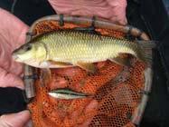
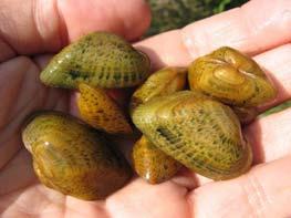
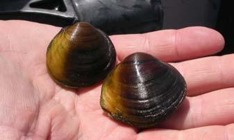
9 Mussel Species at Risk 41 species of freshwater mussels in ON Currently 13 SAR listed by COSEWIC (~1/3) 8 spp listed under SARA; 5 under consideration Sydenham, Ausable, Thames & Grand Rivers as Refuges

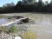
10 Sydenham River Prime Mussel Habitat


11 Mussel Recovery Strategies
12 Introduction Outline SARA & Critical Habitat Freshwater Mussels Identification Methods Geospatial & Biophysical Summary


13 Critical Habitat ID - Challenges Many data poor species with few records Lack of targeted surveys + insufficient effort to detect Identification expertise generally lacking Habitat needs little known for many SAR Habitat mapping in southern Ontario is limited or nonexistent in many areas with SAR fishes SARA requires ID of CH using best available information Northern Madtom - Endangered
14 Critical Habitat ID Overall Method Features (biophysical) Geo-spatial extent of CH Bounding Box Method: the species area of occupancy associated with a description of a defined feature whose location may or may not be known.

15 Approaches for ID of CH for Fishes Recovery Target Dependent Whole Waterbody Convex Polygon Ecological Classification
 If species is present in a segment (recent records of live animals or fresh shells for mussels), assumed throughout")
16 Ecological Classification Aquatic Landscape Inventory System (ALIS; Stanfield and Kuyvenhoven 2005): streams broken down into homogenous valley segments based on controlling variables (e.g. surficial geology, slope, barriers) If species is present in a segment (recent records of live animals or fresh shells for mussels), assumed throughout

17 Kidneyshell Ausable River Draft CH extent includes bankfull width

18 Northern Riffleshell Ausable River

19 Snuffbox Ausable River

20 Round Hickorynut Sydenham River


21 Kidneyshell Sydenham River * CH overlaps with 5 other SAR mussels

22 Round Pigtoe Bear Creek

23 Kidneyshell Thames River

24 Rayed Bean Thames River

25 Round Pigtoe Lower Grand River

26 Kidneyshell CH (Biophysical) Critical Habitat: areas must support one or more habitat functions within the delineated zones. * Most of the 7 SAR mussels will be very similar (some differences in substrate and host spp)
27 Introduction Outline SARA & Critical Habitat Freshwater Mussels Identification Methods Geospatial & Biophysical Summary
28 Summary Sydenham, Ausable, Thames and Grand Rivers support CH for 7 SAR Mussels and are important refugia Bounding Box approach allows ID of CH when basic habitat needs are known and habitats are unmapped Incorporates ecological variability (features can shift) Use of an ecological classification (ALIS) with basic occurrence data provides a good first cut for determining CH boundaries (bounding box) Site-specific information req d for decision making to determine presence of CH within Bounding Box (not just a no touch zone )
29 Summary Host fish are an important component of CH for mussel SAR and would receive protection during the encystment phase ID of CH under SARA will allow for greater habitat protection than the Fisheries Act currently provides Proposed works or undertakings within CH areas will be assessed through the SAR permitting process currently in place. Additional research required to improve our understanding of habitat needs (and tolerances) for SAR mussels for protection of CH
30 Questions?
31
File Geodatabase Feature Class
 Page 1 of 9 Fisheries and Oceans Canada Species at Risk Distribution (Range) File Geodatabase Feature Class Tags Molluscs, Protected species, Science, Endangered species, Fisheries management, Freshwater
Fisheries and Oceans Canada Species at Risk. File Geodatabase Feature Class
 Page 1 of 12 Fisheries and Oceans Canada Species at Risk File Geodatabase Feature Class Tags Molluscs, Protected species, Science, Endangered species, Fisheries management, Freshwater fish, Salt water
Why Erosion and Sedimention Control is Important: A Fish s Point of View
 Why Erosion and Sedimention Control is Important: A Fish s Point of View Fisheries Protection Program Department of Fisheries and Oceans June 6, 2014 Basic definition: Sediment is defined as soil particles
RAILWAYS AND FISH: HOW TO PROTECT AND ENHANCE FISH HABITAT VALUES AT STREAM CROSSINGS THROUGH PROJECT DESIGN AND CONSTRUCTION
 RAILWAYS AND FISH: HOW TO PROTECT AND ENHANCE FISH HABITAT VALUES AT STREAM CROSSINGS THROUGH PROJECT DESIGN AND CONSTRUCTION Rail Environment Conference November 2016 AGENDA Objective Background Benefits
Mobrand to Jones and Stokes. Sustainable Fisheries Management Use of EDT
 Sustainable Fisheries Management Use of EDT Ecosystem Diagnosis and Treatment EDT EDT designed to provide a practical, science-based approach for developing and implementing watershed plans. Provides decision
Framework for the Basin-Wide Socio-Economic Analysis of Four Proposed Sediment Diversions. August 4, 2015
 Framework for the Basin-Wide Socio-Economic Analysis of Four Proposed Sediment Diversions August 4, 2015 Proposed Sediment Diversions Mid-Breton Mid-Barataria Lower Barataria Lower Breton Overview of Presentation
When Creek Meets Valley Wall: Prioritizing Erosion Mitigation alongside the Oshawa Landfill
 1 When Creek Meets Valley Wall: Prioritizing Erosion Mitigation alongside the Oshawa Landfill Robin McKillop 1, Dan McParland 1 & Cassie Scobie 2 TRIECA conference March 22-23, 2017 1 Palmer Environmental
Addressing the Impact of Road-Stream Crossing Structures on the Movement of Aquatic Organisms
 Scott Jackson University of Massachusetts Amherst Addressing the Impact of Road-Stream Crossing Structures on the Movement of Aquatic Organisms Dams Sub-standard Culverts Excessive Velocities Inlet Drop
Spatial Decision-Support for National Marine Conservation Areas in the Southern Strait of Georgia and Gwaii Haanas
 Spatial Decision-Support for National Marine Conservation Areas in the Southern Strait of Georgia and Gwaii Haanas Lindsay McBlane Krista Royle Greg MacMillan Photo: Mark Hiebert Western and Northern Service
Environmental. Plan Update. By Jodie Pavlica
 E i t l and d Environmental Recreational Analysis Snake Salt Basin Plan Update By Jodie Pavlica i for f oday s d Presentation P t ti opics 1. 2. 3. 4. 5. 6. Recreational and Environmental Uses in the Last
ADDRESSING GEOMORPHIC AND HYDRAULIC CONTROLS IN OFF-CHANNEL HABITAT DESIGN
 ADDRESSING GEOMORPHIC AND HYDRAULIC CONTROLS IN OFF-CHANNEL HABITAT DESIGN Conor Shea - Hydrologist U.S. Fish and Wildlife Service Conservation Partnerships Program Arcata, CA Learning Objectives Examine
The Refugia Concept: Using Watershed Analysis to Prioritize Salmonid Habitat for Conservation and Restoration
 The Refugia Concept: Using Watershed Analysis to Prioritize Salmonid Habitat for Conservation and Restoration Christopher May Battelle & UW Cumulative Impacts of Urbanization Landscape Alterations Loss
HABITAT EFFECTIVENESS AND SECURITY AREA ANALYSES
 HABITAT EFFECTIVENESS AND SECURITY AREA ANALYSES ESGBP 194 12. HABITAT EFFECTIVENESS AND SECURITY AREA ANALYSIS Michael Gibeau As demands on the land increase, cumulative effects result from individually
APPENDIX 15-S KSM PROJECT: 2012 FISH BEARING STATUS ASSESSMENT MEMORANDUM
 APPENDIX 15-S KSM PROJECT: 2012 FISH BEARING STATUS ASSESSMENT MEMORANDUM TM Memorandum Refer to File No.: N:\868 Seabridge\868-017 KSM 2012 Fieldwork\868- DATE: December 17, 2012 017-19 Fisheries - Treaty
What standard are we focusing on today?
 What standard are we focusing on today? Standard H.B.6 The student will demonstrate an understanding that ecosystems are complex, interactive systems that include both biological communities and physical
Designing Networks of Marine Protected Areas in DFO s Three Atlantic Bioregions
 Designing Networks of Marine Protected Areas in DFO s Three Atlantic Bioregions Presentation for Indigenous Protected Areas Workshop Max Westhead, DFO and Adrian Gerhartz-Abraham, Dalhousie March 29, 2017
Bob Van Dolah. Marine Resources Research Institute South Carolina Department of Natural Resources
 Bob Van Dolah Marine Resources Research Institute South Carolina Department of Natural Resources Shoreline Change Will Occur! On our front beaches where it is not easy to retreat Shoreline Change Will
Canada s Policy for the Conservation of Wild Pacific Salmon: conservation planning for an uncertain future.
 Canada s Policy for the Conservation of Wild Pacific Salmon: conservation planning for an uncertain future. Brian Riddell and Blair Holtby, Dept. Fisheries & Oceans, Science Branch, Pacific Biological
Biosphere Biome Ecosystem Community Population Organism
 Ecology ecology - The study of living things and how they relate to their environment Levels of Organization in Ecology organism lowest level one living thing population collection of organisms of the
Cowichan Estuary Habitat Mapping and Oyster Population Assessment. Cowichan Stewardship Round Table
 Cowichan Estuary Habitat Mapping and Oyster Population Assessment Presentation at Cowichan Stewardship Round Table June 21, 2018 By Dr. Goetz Schuerholz 1 More than 8000 drone photos taken stitched together
A NEW GIS-BASED RIVER BASIN FRAMEWORK
 A NEW GIS-BASED RIVER BASIN FRAMEWORK FOR AQUATIC ECOSYSTEM CONSERVATION IN THE AMAZON www.amazonwaters.org info@amazonwaters.org 2 3 Introduction The Amazon Waters Initiative is a call to action to conceptualize
The Freshwater Pearl Mussel: Threats and Conservation
 The Freshwater Pearl Mussel: Threats and Conservation Prof. Dr. Jürgen Geist Aquatic Systems Biology Unit geist@wzw.tum.de Freshwater Mussels in Peril Redrawn from The Nature Conservancy and NatureServe
Community Structure. Community An assemblage of all the populations interacting in an area
 Community Structure Community An assemblage of all the populations interacting in an area Community Ecology The ecological community is the set of plant and animal species that occupy an area Questions
Case Study 2: Twenty-mile Creek Rock Fords
 Case Study : Twenty-mile Creek Rock Fords Location Crossing Description Washington. Okanagan National Forest. Methow Valley Ranger District. Chewuch river basin, East Chewuch Road. The Twenty-mile Creek
Species at Risk Act Implementation Guidance for Recovery Practitioners
 Species at Risk Act Implementation Guidance for Recovery Practitioners Critical Habitat Identification Toolbox Developed by Environment and Climate Change Canada Canadian Wildlife Service Critical Habitat
Assessing Michigan s Biological diversity. Michigan Natural Features Inventory MSU Extension
 Assessing Michigan s Biological diversity John Paskus,, Amy Derosier,, Edward Schools, and Helen Enander Michigan Natural Features Inventory MSU Extension Goal Provide scientifically based information
The Use of Higher-Resolution Satellite Imagery, LiDAR and Drones in River Applications:
 The Use of Higher-Resolution Satellite Imagery, LiDAR and Drones in River Applications: Meander Belt Width Assessments to Effluent Plume Delineation Joanna Eyquem, P.Geo., Principal Fluvial Geomorphology,
Geovisualization of shipping noise exposure for whales in Canada. Simone Cominelli; Brent Hall; Michael Leahy; Michael Luubert
 Geovisualization of shipping noise exposure for whales in Canada Simone Cominelli; Brent Hall; Michael Leahy; Michael Luubert Introduction ANTHROPOGENIC NOISE, SHIPPING AND CETACEANS ANTHROPOGENIC NOISE
Appendix 12J Winter-Run Chinook Salmon Life Cycle Modeling
 Appendix 12J Winter-Run Chinook Salmon Life Cycle Modeling Line items and numbers identified or noted as No Action Alternative represent the Existing Conditions/No Project/No Action Condition (described
MEMORANDUM OF UNDERSTANDING ON THE CONSERVATION OF MIGRATORY SHARKS HABITAT CONSERVATION. (Prepared by the Advisory Committee)
") MEMORANDUM OF UNDERSTANDING ON THE CONSERVATION OF MIGRATORY SHARKS CMS/Sharks/MOS3/Doc.10.2 24 August 2018 Original: English 3 rd Meeting of the Signatories (Sharks MOS3) Monaco, 10 14 December 2018 Agenda
MEMORANDUM OF UNDERSTANDING ON THE CONSERVATION OF MIGRATORY SHARKS CMS/Sharks/MOS3/Doc.10.2 24 August 2018 Original: English 3 rd Meeting of the Signatories (Sharks MOS3) Monaco, 10 14 December 2018 Agenda
Land Accounts - The Canadian Experience
 Land Accounts - The Canadian Experience Development of a Geospatial database to measure the effect of human activity on the environment Who is doing Land Accounts Statistics Canada (national) Component
Simplistic view of energy flow Linear path Lacks other possible pathways energy can be passed. Food Chain?
 Simplistic view of energy flow Linear path Lacks other possible pathways energy can be passed. Food Chain? Realistic view of energy passage. Combines food chains. Food Web? Energy Pyramid Quaternary Consumer
Using Grassland Vegetation Inventory Data
 Adam Moltzahn Eastern Short-Horned Lizard Using Grassland Vegetation Inventory Data The GVI represents the Government of Alberta s comprehensive biophysical, anthropogenic and land-use inventory of the
Outline. Ecology: Succession and Life Strategies. Interactions within communities of organisms. Key Concepts:
 Ecology: Succession and Life Strategies Interactions within communities of organisms u 1. Key concepts Outline u 2. Ecosystems and communities u 3. Competition, Predation, Commensalism, Mutualism, Parasitism
BOEM Marine Minerals Program
 BOEM Marine Minerals Program Restoring and Protecting Our Nation s Coasts through Stewardship of OCS Sand Resources SECOORA 2018 Annual Meeting May 22-24 Doug Piatkowski Douglas.piatkowski@boem.gov 703-787-1833
FRAMEWORK FOR CHARACTERIZING CONSERVATION UNITS OF PACIFIC SALMON (ONCORHYNCHUS SPP.) FOR IMPLEMENTING THE WILD SALMON POLICY
 FOR IMPLEMENTING THE WILD SALMON POLICY") Canadian Science Advisory Secretariat Science Advisory Report 2008/052 FRAMEWORK FOR CHARACTERIZING CONSERVATION UNITS OF PACIFIC SALMON (ONCORHYNCHUS SPP.) FOR IMPLEMENTING THE WILD SALMON POLICY Figure
Canadian Science Advisory Secretariat Science Advisory Report 2008/052 FRAMEWORK FOR CHARACTERIZING CONSERVATION UNITS OF PACIFIC SALMON (ONCORHYNCHUS SPP.) FOR IMPLEMENTING THE WILD SALMON POLICY Figure
Natural Resource Management. Northern Tasmania. Strategy. Appendix 2
 Natural Resource Management Strategy Northern Tasmania 2015 2020 Appendix 2 Appendix 2 Appendix 2. Carbon Planting Spatial Prioritisation In support of this Strategy s development and implementation, work
Australia s Marine Bioregional Planning
 Australia s Marine Bioregional Planning And possible lessons for areas beyond national jurisdiction Nautilus (Dr M. Norman, Museum Victoria) Butterfly fish & Yellowback Fusiliners (R.Thorn) Soft coral
Wisconsin s Invasive Species Classification Assessment and Rule
 Wisconsin s Invasive Species Classification Assessment and Rule The Process Legislature gave WIDNR authority to create an invasive species classification system. Legislature also created Wis. Council on
Natural Shoreline Landscapes on Michigan Inland Lakes
 Natural Shoreline Landscapes on Michigan Inland Lakes Excerpts from Chapters 2 and 3 Photo Photo by Jane by Jane Herbert Herbert Did you know? Twenty-four species of amphibians, 25 species of reptiles,
NOTES: CH 4 Ecosystems & Communities
 NOTES: CH 4 Ecosystems & Communities 4.1 - Weather & Climate: WEATHER = day-to-day conditions of Earth s atmosphere CLIMATE= refers to average conditions over long periods; defined by year-afteryear patterns
Background. North Cascades Ecosystem Grizzly Bear Restoration Plan/ Environmental Impact Statement. Steve Rochetta
 Grizzly Bear Restoration Plan/ Environmental Impact Statement Steve Rochetta Background Situated in the core of the North Cascades ecosystem (NCE), the North Cascades National Park Complex is surrounded
4. Ecology and Population Biology
 4. Ecology and Population Biology 4.1 Ecology and The Energy Cycle 4.2 Ecological Cycles 4.3 Population Growth and Models 4.4 Population Growth and Limiting Factors 4.5 Community Structure and Biogeography
CHAPTER 1 INTRODUCTION
 CONTENTS Page No. CHAPTER 1 INTRODUCTION 1.1 LOCATION OF THE PROJECT 1-1 1.2 BACKGROUND 1-1 1.2.1 Previous Studies 1-2 1.2.2 NHPC Proposal 1-2 1.2.3 Work after Submission of PFR 1-3 1.3 PROJECT AREA 1-3
Blue Mountain Province
 Rolling Provincial Review: Implementation 2001-2003 Province 23 Columbia Basin Fish & Wildlife Authority Province FY 2001-2003 Spending Summaries NPCC Recommendations and BPA Spending by Project Category,
An Introduction to Day Two. Linking Conservation and Transportation Planning Lakewood, Colorado August 15-16, 16, 2006
 An Introduction to Day Two Linking Conservation and Transportation Planning Lakewood, Colorado August 15-16, 16, 2006 1 Agenda Day One Transportation Planning Heritage Program State Wildlife Action Plan
Introduction to Part III Examining wildlife distributions and abundance using boat surveys
 Baseline Wildlife Studies in Atlantic Waters Offshore of Maryland: Final Report to the Maryland Department of Natural Resources and Maryland Energy Administration, 2015 Introduction to Part III Examining
Modeling Fish Assemblages in Stream Networks Representation of Stream Network Introduction habitat attributes Criteria for Success
 Modeling Fish Assemblages in Stream Networks Joan P. Baker and Denis White Western Ecology Division National Health & Environmental Effects Research Laboratory U.S. Environmental Protection Agency baker.joan@epa.gov
Grant Opportunity Monitoring Bi-State Sage-grouse Populations in Nevada
 Grant Opportunity Monitoring Bi-State Sage-grouse Populations in Nevada Proposals are due no later than November 13, 2015. Grant proposal and any questions should be directed to: Shawn Espinosa @ sepsinosa@ndow.org.
Good Morning! When the bell rings we will be filling out AP Paper work.
 Good Morning! Turn in HW into bin or email to smithm9@fultonschools.org If you do not want to tear the lab out of your notebook take a picture and email it. When the bell rings we will be filling out AP
Using Big Interagency Databases to Identify Climate Refugia for Idaho s Species of Concern
 Using Big Interagency Databases to Identify Climate Refugia for Idaho s Species of Concern What is a Climate Refugia? habitat that supports a locally reproducing population [or key life history stage]
Stream Restoration and Environmental River Mechanics. Objectives. Pierre Y. Julien. 1. Peligre Dam in Haiti (deforestation)
") Stream Restoration and Environmental River Mechanics Pierre Y. Julien Malaysia 2004 Objectives Brief overview of environmental river mechanics and stream restoration: 1. Typical problems in environmental
Stream Restoration and Environmental River Mechanics Pierre Y. Julien Malaysia 2004 Objectives Brief overview of environmental river mechanics and stream restoration: 1. Typical problems in environmental
Relatively little hard substrate occurs naturally in the
 CHAPTER FIVE Rock Habitats Relatively little hard substrate occurs naturally in the estuary, owing mainly to the vast quantities of fine sediment that have been deposited by the rivers. Rock habitat is
Getting Biodiversity Data
 Getting Biodiversity Data NatureServe Canada Douglas Hyde Executive Director Value of biodiversity data to business? Reasons vary depending on the business Reduce development uncertainty Integrated views
Section B - Chapter 13 Neuse River Subbasin Bay River and Pamlico Sound
 Section B - Chapter 13 Neuse River Subbasin 3-4-13 Bay River and Pamlico Sound 13.1 Subbasin Overview Subbasin 3-4-13 at a Glance Land and Water Area Total area: 277 mi 2 Land area: 145 mi 2 Water area:
Types of Wetlands. Tidal Systems
 Types of Wetlands Tidal Systems 1 COASTAL WETLAND ECOSYSTEMS Tidal Salt Marshes Tidal Freshwater Marshes Mangrove Wetlands 2 Tidal Estuarine Wetland 3 Definition and Formation of Estuaries Estuary: : partially
Subtidal permanently flooded with tidal water. Irregularly exposed surface exposed by tides less often than daily
 Types of Wetlands Tidal Systems COASTAL WETLAND ECOSYSTEMS Tidal Salt Marshes Tidal Freshwater Marshes Mangrove Wetlands Tidal Estuarine Wetland 1 Definition and Formation of Estuaries u Estuary : partially
Grizzly Bear Value Summary April 2016
 Grizzly Bear Value Summary April 2016 The Cumulative Effects Framework (CEF) provides statutory decision-makers and resource managers with critical information for managing cumulative effects on CEF values
THE RED BOOK OF PLANTS OF THE REPUBLIC OF ARMENIA
 THE RED BOOK OF PLANTS OF THE REPUBLIC OF ARMENIA Dear compatriots, Armenia is one of the corners of the Caucasus. The country s attractiveness and public welfare are directly linked with the splendour
2012 FORUM OF MARINE PROTECTED AREAS IN THE MEDITERRANEAN ANTALYA, TURKEY
 2012 FORUM OF MARINE PROTECTED AREAS IN THE MEDITERRANEAN ANTALYA, TURKEY SPECIAL EVENT Challenges for Open Seas MPAs in the Mediterranean region November 27, 2012. 15h00-16H00 Slide # 1 2012 FORUM OF
Winter Skate Leucoraje ocellata.
 Addendum to COSEWIC 2015 Status Report for the Winter Skate Leucoraje ocellata. 2017 Fisheries and Oceans Canada (DFO) has requested that COSEWIC reconsider the designatable unit (DU) structure for Winter
Land Information Ontario Data Description. Source Protection Area Generalized
 Unclassified Land Information Ontario Data Description Source Protection Area Generalized Disclaimer This technical documentation has been prepared by the Ministry of Natural Resources (the Ministry ),
COSSARO Candidate Species at Risk Evaluation. for
 COSSARO Candidate Species at Risk Evaluation for Large Whorled Pogonia (Isotria verticillata) Committee on the Status of Species at Risk in Ontario (COSSARO) Assessed by COSSARO as ENDANGERED December
Abiotic, Biotic and Cultural Resource Survey for Land Planning Along the Rideau Canal
 Abiotic, Biotic and Cultural Resource Survey for Land Planning Along the Rideau Canal Executive Summary The intent of this study was to test a mapping method to determine its effectiveness as a tool for
Southwest LRT Habitat Analysis. May 2016 Southwest LRT Project Technical Report
 Southwest LRT Habitat Analysis Southwest LRT Project Technical Report This page intentionally blank. Executive Summary This technical report describes the habitat analysis that was performed to support
Course Introduction VI Physical Aspects of Culture
 Exercise 1 Human Adaptation (cultural ecology) Discuss how the regional physical geography influenced the development of unique cultural traits in two distinct areas of the world. GRADE DISTRIBUTION 9
AGGREGATE RESOURCES OF ONTARIO (ARO) METADATA
 METADATA") AGGREGATE RESOURCES OF ONTARIO (ARO) METADATA GENERAL INFORMATION Official Name of the Data Set or Information Holding: Aggregate Resources of Ontario Acronyms are Used to Identify the Data Set or Information
AGGREGATE RESOURCES OF ONTARIO (ARO) METADATA GENERAL INFORMATION Official Name of the Data Set or Information Holding: Aggregate Resources of Ontario Acronyms are Used to Identify the Data Set or Information
An Integrated Habitat Classification and Map of the Lake Erie Basin: Final Report
 An Integrated Habitat Classification and Map of the Lake Erie Basin: Final Report Dr. Lucinda Johnson Natural Resources Research Institute University of Minnesota 5013 Miller Trunk Highway, Duluth, MN
Project 4 Wildlife Technical Report. Lake. Winnipeg. Project 4 WTR. Ecological Land Classification in the Project 4 Study Area
 Ecoregion Number and Ecodistrict Name 90, Berens River 90, Wrong Project 1: PR304 to Berens River Project 4: to Transmission Line Ecodistricts: Government of Canada, Agriculture and Agri-Food Canada, Ecological
Krešimir Žganec, doc. dr. sc. University of Zadar
 Krešimir Žganec, doc. dr. sc. University of Zadar Project aim: highlight the most outstanding freshwater/river ecosystems in Serbia Expected results: A map showing the most outstanding freshwater ecosystems
Stream Ecological Assessment in Virginia Using INSTAR. Greg Garman Leonard Smock Stephen McIninch William Shuart Virginia Commonwealth University
 Stream Ecological Assessment in Virginia Using INSTAR Greg Garman Leonard Smock Stephen McIninch William Shuart Virginia Commonwealth University Interactive Stream Assessment Resource (INSTAR( INSTAR)
Sediment Management in the Coastal Bays
 Sediment Management in the Coastal Bays Introduction Need for ecosystem view of sediment management in Coastal Bays Island loss and restoration Navigation needs Habitat Trade offs Living Shoreline Requirements
Priority areas for grizzly bear conservation in western North America: an analysis of habitat and population viability INTRODUCTION METHODS
 Priority areas for grizzly bear conservation in western North America: an analysis of habitat and population viability. Carroll, C. 2005. Klamath Center for Conservation Research, Orleans, CA. Revised
Name Hour. Section 4-1 The Role of Climate (pages 87-89) What Is Climate? (page 87) 1. How is weather different from climate?
 What Is Climate? (page 87) 1. How is weather different from climate?") Name Hour Section 4-1 The Role of Climate (pages 87-89) What Is Climate? (page 87) 1. How is weather different from climate? 2. What factors cause climate? The Greenhouse Effect (page 87) 3. Circle the
Name Hour Section 4-1 The Role of Climate (pages 87-89) What Is Climate? (page 87) 1. How is weather different from climate? 2. What factors cause climate? The Greenhouse Effect (page 87) 3. Circle the
Principles of Ecology
 Principles of Ecology Ecology is the scientific study of interactions between 1. organisms and other organisms 2. organisms and their environment. Biotic vs. Abiotic Factors Biotic Factors: All of the
Chapter 52 An Introduction to Ecology and the Biosphere
 Chapter 52 An Introduction to Ecology and the Biosphere Ecology The study of the interactions between organisms and their environment. Ecology Integrates all areas of biological research and informs environmental
Fig 1. Steps in the EcoValue Project
 Assessing the Social and Economic Value of Ecosystem Services in the Northern Forest Region: A Geographic Information System (GIS) Approach to Landscape Valuation Principal Investigator(s): Dr. Matthew
Pee Dee Explorer. Science Standards
 Science Standards About Pee Dee Explorer What does it mean when someone says they are from the "Pee Dee" of South Carolina? A place is bigger than its physical geography. A "sense of place" weaves together
Biodiversity Classwork Classwork #1
 Biodiversity Classwork Classwork #1 1. What is biodiversity? 2. In the boxes below, create two ecosystems: one with low biodiversity and one with high biodiversity. Explain the difference. Biodiversity
TEST NAME: Biome Test 10/7 TEST ID: GRADE:05 - Fifth Grade SUBJECT:Life and Physical Sciences TEST CATEGORY: My Classroom
 TEST NAME: Biome Test 10/7 TEST ID:1239163 GRADE:05 - Fifth Grade SUBJECT:Life and Physical Sciences TEST CATEGORY: My Classroom Biome Test 10/7 Page 1 of 8 10/07/16, Biome Test 10/7 Student: Class: Date:
Lower South Fork McKenzie River Floodplain Enhancement Project
 Lower South Fork McKenzie River Floodplain Enhancement Project McKenzie River Ranger District Willamette National Forest Project Location The project is located in the South Fork McKenzie River Watershed,
Spatial Graph Theory for Cross-scale Connectivity Analysis
 Spatial Graph Theory for Cross-scale Connectivity Analysis Andrew Fall School of Resource and Environmental Management, SFU and Gowlland Technologies Ltd., Victoria, BC Acknowledgements Marie-Josée Fortin,
WEBINAR AGENDA. Review of connectivity mapping progress to date. Describe draft methodology for delineating and validating core areas
 WEBINAR AGENDA Review of connectivity mapping progress to date Describe draft methodology for delineating and validating core areas Review examples of the methodology implemented in the Highlands Explain
Module 3. Basic Ecological Principles
 Module 3. Basic Ecological Principles Ecosystem Components Abiotic Biotic Species & Habitat The Biomes of North America Communities Energy & Matter Cycles in Ecosystems Primary Productivity Simple Ecosystem
Columbia Estuary Province
 Rolling Provincial Review: Implementation 2001-2004 Province 73 Columbia Basin Fish & Wildlife Authority Province FY 2001-2004 Spending Summaries NPCC Recommendations and BPA Spending by Project Category,
MPA_Inventory_GIS_Database
 MPA_Inventory_GIS_Database Metadata also available as Frequently-anticipated questions: What does this data set describe? 1. How should this data set be cited? 2. What geographic area does the data set
Environmental Response Management Application
 Environmental Response Management Application Coastal Response Research Center Nancy Kinner, Michele Jacobi, Rob Braswell, Kurt Schwehr & Amy Merten RRT III May 14, 2008 1 Talk Outline Overview of Center
THE DIGITAL TERRAIN MAP LIBRARY: AN EXPLORATIONIST S RESOURCE
 THE DIGITAL TERRAIN MAP LIBRARY: AN EXPLORATIONIST S RESOURCE By I.C.L. Webster, P.J. Desjardins and W.E. Kilby KEYWORDS: digital terrain maps, digital terrain stability maps, surficial geology, GIS, raster
Identifying Sensitive Marine Areas: A tour of the legal and scientific criteria
 Identifying Sensitive Marine Areas: A tour of the legal and scientific criteria CIL High Seas Governance: Gaps and Challenges Panel 1 on Sensitive Marine Areas 24-25 April 2017, Singapore Youna Lyons,
An Introduction to NatureServe Linking Conservation and Transportation Planning Phoenix, Arizona November 8 & 9, 2006
 An Introduction to NatureServe Linking Conservation and Transportation Planning Phoenix, Arizona November 8 & 9, 2006 1 NatureServe in Brief An independent, non-profit conservation organization Provides
HABITAT SUITABILITY MODELS: RESEARCH AND MANAGEMENT
 HABITAT SUITABILITY MODELS: RESEARCH AND MANAGEMENT Mark Barrett, Ph.D. Florida Fish and Wildlife Conservation Commission Fish and Wildlife Research Institute Center for Spatial Analysis George Box (1976)
HCSA Peer Review Report Korindo - PT. Tunas Sawaerma (POP A) (PT. TSE)
 (PT. TSE)") HCSA Peer Review Report Korindo - PT. Tunas Sawaerma (POP A) (PT. TSE) Background information: a) Did a Registered Practitioner Organisation lead the HCS assessment? If not, has the organisation which
HCSA Peer Review Report Korindo - PT. Tunas Sawaerma (POP A) (PT. TSE) Background information: a) Did a Registered Practitioner Organisation lead the HCS assessment? If not, has the organisation which
adaptation any structure or behavior of an organism that allows it to survive in its environment (IG)
") FOSS Environments Module Glossary NGSS Edition 2019 adaptation any structure or behavior of an organism that allows it to survive in its environment (IG) adult a fully grown organism (IG) algae a large
FOSS Environments Module Glossary NGSS Edition 2019 adaptation any structure or behavior of an organism that allows it to survive in its environment (IG) adult a fully grown organism (IG) algae a large
A Small Migrating Herd. Mapping Wildlife Distribution 1. Mapping Wildlife Distribution 2. Conservation & Reserve Management
 A Basic Introduction to Wildlife Mapping & Modeling ~~~~~~~~~~ Rev. Ronald J. Wasowski, C.S.C. Associate Professor of Environmental Science University of Portland Portland, Oregon 8 December 2015 Introduction
Birch Creek Geomorphic Assessment and Action Plan
 Birch Creek Geomorphic Assessment and Action Plan Jim Webster Tim Hanrahan, PhD, CFM Jesse Schwartz, PhD Zach Hill January 22, 2015 White Eagle Grange This Project is a First Step in Strategy Planning
Community Mapping Network. Selected Coastal Atlases and Information Systems in British Columbia, Canada
 Community Mapping Network Selected Coastal Atlases and Information Systems in British Columbia, Canada Outline Community Mapping Network cmnbc.ca Pacific Coastal Resources Atlas for BC cmnbc.ca The Living
Giant Salvinia Overview & History Restore America s Estuaries & The Coastal Society 2016 Summit December 15, 2016
 Giant Salvinia Overview & History Restore America s Estuaries & The Coastal Society 2016 Summit December 15, 2016 Jillian Day Aquatic Plant Control Coordinator Inland Fisheries Giant Salvinia Native to
Trinity River Sub basin Environmental Flows Data Report for Quality Assured Data Collected between September 1, 2014 and June 30, 2015.
 Trinity River Sub basin Environmental Flows Data Report for Quality Assured Data Collected between September 1, 2014 and June 30, 2015 Final Report August 1, 2015 Trinity River Sub basin Environmental
On the Feasibility of Quantitative Population Viability Analysis in Recovery Planning: Efforts to Bridge the Gap Between Theory and Practice
 On the Feasibility of Quantitative Population Viability Analysis in Recovery Planning: Efforts to Bridge the Gap Between Theory and Practice LUTZ TISCHENDORF 1 AND KATHRYN LINDSAY 2 1 ELUTIS Modeling and
Conserving freshwater ecosystem values in Tasmania, Australia: identification and application of freshwater conservation management priority areas
 Conserving freshwater ecosystem values in Tasmania, Australia: identification and application of freshwater conservation management priority areas Danielle Hardie 1 and Peter Davies 2 1 Department of Primary