HABITAT SUITABILITY MODELS: RESEARCH AND MANAGEMENT
|
|
|
- Nora Goodman
- 5 years ago
- Views:
Transcription


1 HABITAT SUITABILITY MODELS: RESEARCH AND MANAGEMENT Mark Barrett, Ph.D. Florida Fish and Wildlife Conservation Commission Fish and Wildlife Research Institute Center for Spatial Analysis George Box (1976) All models are wrong but some are useful David Hand (2014) when building statistical models, we must not forget that the aim is to understand something about the real world not an abstract mathematical world
")
2 POTENTIAL HABITAT MODELS SPECIES DATA ENVIRONMENTAL VARIABLES ALGORITHM POTENTIAL HABITAT (Not occupancy) algorithm
3 GENERAL MODEL TYPES Model Classification Complexity Process Result Habitat Affinity Binary (0,1) Simple Descriptive Index Fuzzy Logic Continuous (0-1) Intermediate Descriptive statistics State or extent of event Predictive* Continuous (0-1) Complex Statistical model** Probability/Likelihood * Presence-only, presence/absence, abundance ** Algorithms: - Resource Selection Function (GLM (Logistic Regression)) - Machine Learning (Maxent, Random Forest, Boosted Regression Trees) - Neural Networks - Envelope (BIOCLIM) - Occupancy - Model Averaging / Ensemble Models Explanatory (ecological) power vs Predictive (mapping) power e.g., GLM > e.g., Machine Learning


4 INCREASING INFORMATION: [Unsampled areas] RANGE MAP > OCCURRENCES > HABITAT AFFINITY > PREDICTIVE


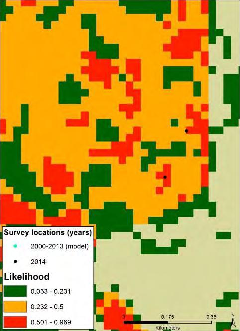
5 Striped Newt Predictive Model Use current location data (~ last 10 yr) Use current environ. variables P o t e n t i a l h a b i t a t

6 CONTINUOUS SCALE OUTPUT BINARY SCALE OUTPUT Threshold = 0.231
 VARIABLE IMPORTANCE Based on jacknife tests, the variable with the most influence on the model was elevation followed by distance to")
7 MODEL VALIDATION AUC = Species Sample Confusion Matrix (based on 10 Percentile Threshold) Model Threshold % Pres Abs Pres Abs True Skill Statistic (TSS) = 0.73 Species expert feedback/ review Independent data (new surveys) VARIABLE IMPORTANCE Based on jacknife tests, the variable with the most influence on the model was elevation followed by distance to wetland and TPI. However, CI overlaps for most variables, so likely not large distinction in rank. Example of response to DEM When variable removed from model
8 MODEL FIT TO LOCATION DATA Refine post model? Min patch size Connectivity
9 Striped Newt Independent data


10

")

11 Comparing Models Model Area (ha) Difference (ha) Affinity 244,576 Predictive 158,706-85,870
12 UPDATING MODELS UPDATE WHCNIF 2009 AFFINITY MODELS TO CURRENT (2016) DATA - SIMILAR METHODS - UPDATED DATA LAYERS: LAND COVER FROM FWC 2003 (30M) TO CLC 2016 (10M) SPECIES 2003 model (ha) 2016 model (ha) Area Diff ** (ha) Scott's seaside sparrow 65,446 67,469 2,023 Louisiana seaside sparrow 192 2,367 2,175 MacGillivray's seaside sparrow 20,241 21, Short-tailed hawk 1,696,174 1,650,411-45,763 Swallow-tailed kite 3,749,343 3,714,812-34,531 **Most differences not from true LC change but from refining LC mapping methods


13 MODELS TO DATE Taxa Model Bird Mammal Herp Fish Invert Total Affinity Fuzzy logic Predictive Total

14 COMBINING POTENTIAL HABITAT MODELS

15 N = 55 spp


16

17 OCCURRENCE DATA POTENTIAL HABITAT MODELS


18 SPECIES WITH LIMITED RANGE GENERAL TAXA INFORMATION General Taxa Birds Fish Herps Invertebrates Mammals

 program Species management on")


19 Habitat Model Uses - FWC Management Plans - FWC/FWRI Research - USFWS Species Status Reviews - FNAI Critical Lands and Waters Identification Project - Military Lands Natural Resource Management - Development Plans/Permitting (Environmental Consultants) FWC Management Plans The Wildlife Conservation Prioritization and Recovery (WCPR) program Species management on FWC-managed lands - Statewide potential habitat models - Consultation of species experts - Knowledge of local staff - Review of area-specific natural community maps Quantity vs Quality - fire interval - invasive species - predation - competition - hydrology - disturbance proximity soniagandiaga TIME PERIOD: data collected model layers model development model validation/review model used

20 THE TREACHERY OF IMAGES René Magritte This is not a pipe. This is not habitat.

21 THANK YOU Terrestrial, Freshwater, Marine
Incorporating Boosted Regression Trees into Ecological Latent Variable Models
 Incorporating Boosted Regression Trees into Ecological Latent Variable Models Rebecca A. Hutchinson, Li-Ping Liu, Thomas G. Dietterich School of EECS, Oregon State University Motivation Species Distribution
Conserving freshwater ecosystem values in Tasmania, Australia: identification and application of freshwater conservation management priority areas
 Conserving freshwater ecosystem values in Tasmania, Australia: identification and application of freshwater conservation management priority areas Danielle Hardie 1 and Peter Davies 2 1 Department of Primary
Summary Description Municipality of Anchorage. Anchorage Coastal Resource Atlas Project
 Summary Description Municipality of Anchorage Anchorage Coastal Resource Atlas Project By: Thede Tobish, MOA Planner; and Charlie Barnwell, MOA GIS Manager Introduction Local governments often struggle
Florida Natural Areas Inventory. Tracking Florida s Biodiversity
 Florida Natural Areas Inventory Tracking Florida s Biodiversity Mission Collect, interpret, and disseminate ecological information critical to the conservation of Florida s biological diversity Program
RTNCF Species & Habitat Step-down Models
 RTNCF Species & Habitat Step-down Models USFWS Science Support Project Ashton Drew Jaime Collazo, John Stanton, Alexa McKerrow Project Objective Aid with step-down of national population & habitat objectives
Anatrytone logan. Species Distribution Model (SDM) assessment metrics and metadata Common name: Delaware Skipper Date: 17 Nov 2017 Code: anatloga
 assessment metrics and metadata Common name: Delaware Skipper Date: 17 Nov 2017 Code: anatloga") Anatrytone logan Species Distribution Model (SDM) assessment metrics and metadata Common name: Delaware Skipper Date: 17 Nov 2017 Code: anatloga fair TSS=0.74 ability to find new sites This SDM incorporates
Anatrytone logan Species Distribution Model (SDM) assessment metrics and metadata Common name: Delaware Skipper Date: 17 Nov 2017 Code: anatloga fair TSS=0.74 ability to find new sites This SDM incorporates
NatureServe s Federally Listed Species Location Data Play an Important Role in EPA s FIFRA Risk Assessments
 NatureServe s Federally Listed Species Location Data Play an Important Role in EPA s FIFRA Risk Assessments 1 ASHLEA FRANK COMPLIANCE SERVICES INTERNATIONAL FIFRA ENDANGERED SPECIES TASK FORCE BIODIVERSITY
Assessing Michigan s Biological diversity. Michigan Natural Features Inventory MSU Extension
 Assessing Michigan s Biological diversity John Paskus,, Amy Derosier,, Edward Schools, and Helen Enander Michigan Natural Features Inventory MSU Extension Goal Provide scientifically based information
Objectives-Based Vegetation Management
 Objectives-Based Vegetation Management The Florida Fish and Wildlife Conservation Commission s Adaptive Management Program GEORGE OTTO, QUANTITATIVE ECOLOGIST george.otto@myfwc.com 352.327.1761 OBVM has
Spatio-temporal dynamics of Marbled Murrelet hotspots during nesting in nearshore waters along the Washington to California coast
 Western Washington University Western CEDAR Salish Sea Ecosystem Conference 2014 Salish Sea Ecosystem Conference (Seattle, Wash.) May 1st, 10:30 AM - 12:00 PM Spatio-temporal dynamics of Marbled Murrelet
Maximum Entropy and Species Distribution Modeling
 Maximum Entropy and Species Distribution Modeling Rob Schapire Steven Phillips Miro Dudík Also including work by or with: Rob Anderson, Jane Elith, Catherine Graham, Chris Raxworthy, NCEAS Working Group,...
Maximum entropy modeling of species geographic distributions. Steven Phillips. with Miro Dudik & Rob Schapire
 Maximum entropy modeling of species geographic distributions Steven Phillips with Miro Dudik & Rob Schapire Modeling species distributions Yellow-throated Vireo occurrence points environmental variables
Setting Priorities for Eelgrass Conservation and Restoration. Robert Buchsbaum Massachusetts Audubon Society
 Setting Priorities for Eelgrass Conservation and Restoration Robert Buchsbaum Massachusetts Audubon Society Eelgrass habitat values A rich, productive habitat for many marine organisms Nursery habitat
Multi-scale modeling of species distributions, hydrology, & gene flow
 Multi-scale modeling of species distributions, hydrology, & gene flow Douglas R. Leasure PhD. Candidate University of Arkansas Department of Biological Sciences BIG data in GIS http://www.gap.uidaho.edu/portal/datadownload.html
Southwest LRT Habitat Analysis. May 2016 Southwest LRT Project Technical Report
 Southwest LRT Habitat Analysis Southwest LRT Project Technical Report This page intentionally blank. Executive Summary This technical report describes the habitat analysis that was performed to support
Nonlinear Classification
 Nonlinear Classification INFO-4604, Applied Machine Learning University of Colorado Boulder October 5-10, 2017 Prof. Michael Paul Linear Classification Most classifiers we ve seen use linear functions
ATLSS SESI MODEL: Long-Legged and Short-Legged Wading Birds: Foraging Indices
 ATLSS SESI MODEL: Long-Legged and Short-Legged Wading Birds: Foraging Indices Louis J. Gross, University of Tennessee ATLSS.org Provides a relative estimate of quality of pixels as sites for nesting colonies
Landscape Planning and Habitat Metrics
 Landscape Planning and Habitat Metrics Frank W. Davis National Center for Ecological Analysis and Synthesis UC Santa Barbara (Tools for Landscape Biodiversity Planning) Jimmy Kagan Institute for Natural
Through their research, geographers gather a great deal of data about Canada.
 Ecozones What is an Ecozone? Through their research, geographers gather a great deal of data about Canada. To make sense of this information, they often organize and group areas with similar features.
Outline. - Background of coastal and marine conservation - Species distribution modeling (SDM) - Reserve selection analysis. - Results & discussion
 - Reserve selection analysis. - Results & discussion") Application of GIS for data preparation and modeling for coastal and marine conservation planning in Madagascar Rija Rajaonson Technical Assistant, REBIOMA Wildlife Conservation Society Madagascar Outline
Application of GIS for data preparation and modeling for coastal and marine conservation planning in Madagascar Rija Rajaonson Technical Assistant, REBIOMA Wildlife Conservation Society Madagascar Outline
Assessing state-wide biodiversity in the Florida Gap analysis project
 University of Nebraska - Lincoln DigitalCommons@University of Nebraska - Lincoln Nebraska Cooperative Fish & Wildlife Research Unit -- Staff Publications Nebraska Cooperative Fish & Wildlife Research Unit
The FNAI Invasive Plants Program
 The FNAI Invasive Plants Program What we do and how we can help the Northwest FL CISMA Frank Price Invasive Plants Program Manager Staff of 32 Part of FUS and the NatureServe network 100% contract funded
Climate Change Vulnerability Assessment for Species
 Climate Change Vulnerability Assessment for Species SPECIES: Specify whether you are assessing the entire species or particular populations: This tool assesses the vulnerability or resilience of species
Wisconsin s Invasive Species Classification Assessment and Rule
 Wisconsin s Invasive Species Classification Assessment and Rule The Process Legislature gave WIDNR authority to create an invasive species classification system. Legislature also created Wis. Council on
Project Leader: Project Partners:
 UTILIZING LIDAR TO MAP HIGH PRIORITY WOODLAND HABITAT IN ARKANSAS DEVELOPING METHODOLOGY AND CONDUCTING A PILOT PROJECT IN THE OZARK HIGHLANDS TO MAP CURRENT EXTENT, SIZE AND CONDITION Project Summary
Welcome to NetMap Portal Tutorial
 Welcome to NetMap Portal Tutorial Potential Applications What Can you do with the Portal? At least 25 things! 1) Locate the best potential fish habitats. 2) Identify biological hotspots. 3) Map floodplain
Geographic Information Systems, Remote Sensing, and Biodiversity. Mandi Caudill
 Geographic Information Systems, Remote Sensing, and Biodiversity Mandi Caudill Habitat loss and fragmentation are the lead causes attributed to biodiversity loss. Geographic information systems (GIS) and
ANIMAL ECOLOGY (A ECL)
") Animal Ecology (A ECL) 1 ANIMAL ECOLOGY (A ECL) Courses primarily for undergraduates: A ECL 312: Ecology (Cross-listed with BIOL, ENSCI). (3-3) Cr. 4. SS. Prereq: BIOL 211, BIOL 211L, BIOL 212, and BIOL
Animal Ecology (A ECL) 1 ANIMAL ECOLOGY (A ECL) Courses primarily for undergraduates: A ECL 312: Ecology (Cross-listed with BIOL, ENSCI). (3-3) Cr. 4. SS. Prereq: BIOL 211, BIOL 211L, BIOL 212, and BIOL
Data Mining Classification: Alternative Techniques. Lecture Notes for Chapter 5. Introduction to Data Mining
 Data Mining Classification: Alternative Techniques Lecture Notes for Chapter 5 Introduction to Data Mining by Tan, Steinbach, Kumar Tan,Steinbach, Kumar Introduction to Data Mining 4/18/2004 1 Neural networks
The Refugia Concept: Using Watershed Analysis to Prioritize Salmonid Habitat for Conservation and Restoration
 The Refugia Concept: Using Watershed Analysis to Prioritize Salmonid Habitat for Conservation and Restoration Christopher May Battelle & UW Cumulative Impacts of Urbanization Landscape Alterations Loss
Using Big Interagency Databases to Identify Climate Refugia for Idaho s Species of Concern
 Using Big Interagency Databases to Identify Climate Refugia for Idaho s Species of Concern What is a Climate Refugia? habitat that supports a locally reproducing population [or key life history stage]
AUTOMATED ONLINE ECOLOGICAL MODELING AND EVALUATION FOR EVERGLADES MANAGEMENT AND RESTORATION
 AUTOMATED ONLINE ECOLOGICAL MODELING AND EVALUATION FOR EVERGLADES MANAGEMENT AND RESTORATION Leonard Pearlstine 1 Suresh Goldconda 2 Kevin Suir 3 Alicia LoGalbo 1 Craig Conzelmann 3 Janice Parsons 1 1
Remote Sensing Techniques for Renewable Energy Projects. Dr Stuart Clough APEM Ltd
 Remote Sensing Techniques for Renewable Energy Projects Dr Stuart Clough APEM Ltd What is Remote Sensing? The use of aerial sensors to detect and classify objects on Earth Remote sensing for ecological
Overview. How many species are there? Major patterns of diversity Causes of these patterns Conserving biodiversity
 Overview How many species are there? Major patterns of diversity Causes of these patterns Conserving biodiversity Biodiversity The variability among living organisms from all sources, including, inter
Demography and Genetic Structure of the NCDE Grizzly Bear Population. Kate Kendall US Geological Survey Libby, MT Jan 26, 2011
 Demography and Genetic Structure of the NCDE Grizzly Bear Population Kate Kendall US Geological Survey Libby, MT Jan 26, 2011 GRIZZLY BEAR RECOVERY ZONES NEED FOR INFORMATION No baseline data Cabinet -Yaak
Modeling Fish Assemblages in Stream Networks Representation of Stream Network Introduction habitat attributes Criteria for Success
 Modeling Fish Assemblages in Stream Networks Joan P. Baker and Denis White Western Ecology Division National Health & Environmental Effects Research Laboratory U.S. Environmental Protection Agency baker.joan@epa.gov
Sunset Harbour / Huntington Harbour Maintenance Dredging and Waterline Installation Project. CMANC 21 January 2016
 Sunset Harbour / Huntington Harbour Maintenance Dredging and Waterline Installation Project CMANC 21 January 2016 County of Orange Footprint Huntington Harbour Operational and Dredging Cost Sharing Agreements
Data Dictionary for Observation Data Transcription Reports from the Colorado Natural Heritage Program
 Data Dictionary for Observation Data Transcription Reports from the Colorado Natural Heritage Program This Data Dictionary defines terms used in Observation Data Reports exported by the Colorado Natural
Comments. x > w = w > x. Clarification: this course is about getting you to be able to think as a machine learning expert
 Logistic regression Comments Mini-review and feedback These are equivalent: x > w = w > x Clarification: this course is about getting you to be able to think as a machine learning expert There has to be
Species Distribution Modeling
 Species Distribution Modeling Julie Lapidus Scripps College 11 Eli Moss Brown University 11 Objective To characterize the performance of both multiple response and single response machine learning algorithms
Alaska Center for Climate Assessment and Policy
 Alaska Center for Climate Assessment and Policy Welcome to the webinar: CONNECTING ALASKA LANDSCAPES INTO THE FUTURE December 8, 2009 10 AM (ADT) By Nancy Fresco, Scenarios Network for Alaska Planning
Mobrand to Jones and Stokes. Sustainable Fisheries Management Use of EDT
 Sustainable Fisheries Management Use of EDT Ecosystem Diagnosis and Treatment EDT EDT designed to provide a practical, science-based approach for developing and implementing watershed plans. Provides decision
Species Distribution Models
 Species Distribution Models Whitney Preisser ESSM 689 Quantitative Methods in Ecology, Evolution, and Biogeography Overview What are SDMs? What are they used for? Assumptions and Limitations Data Types
USING LANDSCAPE SCALE ESTIMATES OF RELATIVE ELECTROCUTION RISK TO INFORM PRIORITIZATION OF RETROFITS: AN EXAMPLE WITH GOLDEN EAGLES
 USING LANDSCAPE SCALE ESTIMATES OF RELATIVE ELECTROCUTION RISK TO INFORM PRIORITIZATION OF RETROFITS: Gary Williams, Todd Lickfett and Brian Woodbridge USFWS Western Golden Eagle Team AN EXAMPLE WITH GOLDEN
Introduction. Ecology is the scientific study of the interactions between organisms and their environment.
 Introduction Ecology is the scientific study of the interactions between organisms and their environment. 1. The interactions between organisms and their environments determine the distribution and abundance
A Maximum Entropy Approach to Species Distribution Modeling. Rob Schapire Steven Phillips Miro Dudík Rob Anderson.
 A Maximum Entropy Approach to Species Distribution Modeling Rob Schapire Steven Phillips Miro Dudík Rob Anderson www.cs.princeton.edu/ schapire The Problem: Species Habitat Modeling goal: model distribution
Article from. Predictive Analytics and Futurism. July 2016 Issue 13
 Article from Predictive Analytics and Futurism July 2016 Issue 13 Regression and Classification: A Deeper Look By Jeff Heaton Classification and regression are the two most common forms of models fitted
Shawn K. Staton Species at Risk Program Fisheries and Oceans Canada Burlington, Ontario
 Identification of Critical Habitat for Endangered Freshwater Mussels Shawn K. Staton Species at Risk Program Fisheries and Oceans Canada Burlington, Ontario Introduction Outline SARA & Critical Habitat
SHIFTING SEASONS, CLIMATE CHANGE & ECOSYSTEM CONSEQUENCES
 SHIFTING SEASONS, CLIMATE CHANGE & ECOSYSTEM CONSEQUENCES Stephen Thackeray*, Peter Henrys, Deborah Hemming, Chris Huntingford, James Bell, David Leech & Sarah Wanless *sjtr@ceh.ac.uk Phenology & the global
Adaptive Crowdsourcing via EM with Prior
 Adaptive Crowdsourcing via EM with Prior Peter Maginnis and Tanmay Gupta May, 205 In this work, we make two primary contributions: derivation of the EM update for the shifted and rescaled beta prior and
Resolving habitat classification and structure using aerial photography. Michael Wilson Center for Conservation Biology College of William and Mary
 Resolving habitat classification and structure using aerial photography Michael Wilson Center for Conservation Biology College of William and Mary Aerial Photo-interpretation Digitizing features of aerial
EXAM IN STATISTICAL MACHINE LEARNING STATISTISK MASKININLÄRNING
 EXAM IN STATISTICAL MACHINE LEARNING STATISTISK MASKININLÄRNING DATE AND TIME: June 9, 2018, 09.00 14.00 RESPONSIBLE TEACHER: Andreas Svensson NUMBER OF PROBLEMS: 5 AIDING MATERIAL: Calculator, mathematical
Ecosystems and Communities
 Ecosystems and Communities Chapter 4 Section Outline Section 4-1 4 1 The Role of Climate A. What Is Climate? 1. Weather is day to day at a particular time and place 2. Climate is year-to-year averages
Pattern to Process: Research and Applications for Understanding Multiple Interactions and Feedbacks on Land Cover Change (NAG ).
.") Pattern to Process: Research and Applications for Understanding Multiple Interactions and Feedbacks on Land Cover Change (NAG 5 9232). Robert Walker, Principle Investigator Department of Geography 315
Pattern to Process: Research and Applications for Understanding Multiple Interactions and Feedbacks on Land Cover Change (NAG 5 9232). Robert Walker, Principle Investigator Department of Geography 315
Bryan F.J. Manly and Andrew Merrill Western EcoSystems Technology Inc. Laramie and Cheyenne, Wyoming. Contents. 1. Introduction...
 Comments on Statistical Aspects of the U.S. Fish and Wildlife Service's Modeling Framework for the Proposed Revision of Critical Habitat for the Northern Spotted Owl. Bryan F.J. Manly and Andrew Merrill
Nikki Sacha. NRS 509 Restoration Ecology
 Nikki Sacha NRS 509 Restoration Ecology There were several ways that GIS was incorporated into restoration ecology that was repeated in the eight articles that I reviewed. The first was that it served
THE GLOBAL INDICATOR FRAMEWORK: NEW AND INNOVATIVE METHODS FOR DISAGGREGATIN BY GEOLOCATION
 Parallel Session: Measuring and Monitoring the SDGs: THE GLOBAL INDICATOR FRAMEWORK: NEW AND INNOVATIVE METHODS FOR DISAGGREGATIN BY GEOLOCATION from global to regional to national panorama 8 th Meeting
Population Ecology. Study of populations in relation to the environment. Increase population size= endangered species
 Population Basics Population Ecology Study of populations in relation to the environment Purpose: Increase population size= endangered species Decrease population size = pests, invasive species Maintain
論文の内容の要旨. distribution using multi-scale approach in Java Island, Indonesia
 論文の内容の要旨 農学国際専攻 平成 17 年度博士課程 入学 氏名 Syartinilia ( シャルティニリア ) 指導教員名露木聡 論文題目 GIS-Bsed modelling of Javan-Hawk-Eagle (Spizaetus bartelsi) habitat distribution using multi-scale approach in Java Island, Indonesia
National assessment on member s readiness to produce indicators
 Inter-Agency and Expert Group on the Sustainable Development Goal Indicators WORKING GROUP ON GEOSPATIAL INFORMATION Fifth expert meeting 5 and 8 December 2018 8 th Meeting of IAEG-SDGs 5 8 November 2018,
Quantifying effects of oil on coastal dune vegetation. Thomas Miller and Elise Gornish Biological Science, Florida State University
 Quantifying effects of oil on coastal dune vegetation Thomas Miller and Elise Gornish Biological Science, Florida State University Natural History of Barrier Islands in the Northern Gulf Make up ~70% of
Metacommunities Spatial Ecology of Communities
 Spatial Ecology of Communities Four perspectives for multiple species Patch dynamics principles of metapopulation models (patchy pops, Levins) Mass effects principles of source-sink and rescue effects
14.1 Habitat And Niche
 14.1 Habitat And Niche A habitat differs from a niche. Habitat physical area in which an organism lives Niche each species plays a specific role in an ecosystem niche includes the species habitat, feeding
Machine Learning Methods for Radio Host Cross-Identification with Crowdsourced Labels
 Machine Learning Methods for Radio Host Cross-Identification with Crowdsourced Labels Matthew Alger (ANU), Julie Banfield (ANU/WSU), Cheng Soon Ong (Data61/ANU), Ivy Wong (ICRAR/UWA) Slides: http://www.mso.anu.edu.au/~alger/sparcs-vii
Statistical Machine Learning from Data
 Samy Bengio Statistical Machine Learning from Data 1 Statistical Machine Learning from Data Ensembles Samy Bengio IDIAP Research Institute, Martigny, Switzerland, and Ecole Polytechnique Fédérale de Lausanne
UPDATING THE MINNESOTA NATIONAL WETLAND INVENTORY
 UPDATING THE MINNESOTA NATIONAL WETLAND INVENTORY An Integrated Approach Using Object-Oriented Image Analysis, Human Air-Photo Interpretation and Machine Learning AARON SMITH EQUINOX ANALYTICS INC. FUNDING
Krešimir Žganec, doc. dr. sc. University of Zadar
 Krešimir Žganec, doc. dr. sc. University of Zadar Project aim: highlight the most outstanding freshwater/river ecosystems in Serbia Expected results: A map showing the most outstanding freshwater ecosystems
Ecological Site Descriptions ESDs : NRCS Site-based Approach to Land Classification and Evaluation. Nels Barrett, NRCS Ecologist SSSSNE 20
 Ecological Site Descriptions ESDs : NRCS Site-based Approach to Land Classification and Evaluation Nels Barrett, NRCS Ecologist SSSSNE 20 Overview Definition of Ecological Sites, ES Content of Ecological
Taxon: generally refers to any named group of organisms, such as species, genus, family, order, etc.. Node: represents the hypothetical ancestor
 A quick review Taxon: generally refers to any named group of organisms, such as species, genus, family, order, etc.. Node: represents the hypothetical ancestor Branches: lines diverging from a node Root:
CS7267 MACHINE LEARNING
 CS7267 MACHINE LEARNING ENSEMBLE LEARNING Ref: Dr. Ricardo Gutierrez-Osuna at TAMU, and Aarti Singh at CMU Mingon Kang, Ph.D. Computer Science, Kennesaw State University Definition of Ensemble Learning
Building a Spatial Framework for the Analysis of Benthic Fauna Along the River Network of Switzerland
 Building a Spatial Framework for the Analysis of Benthic Fauna Along the River Network of Switzerland Lehmann 1 A., S., Stucki 2 P. and Gonseth 3 Y. 1 University of Geneva, 2 private consultancy, 3 CSCF
GIS 5306 GIS in Environmental Systems
 GIS 5306 GIS in Environmental Systems Week 2: Some more Theory, then Rudimentary Species Distribution Modeling: Habitat Suitability Models and Logistic Regression Last Time Intro and Logistics Main Questions
Floristic Quality Index: Current Methods and Development. Nia Wellendorf Russ Frydenborg DEP Bureau of Labs
 Floristic Quality Index: Current Methods and Development Nia Wellendorf Russ Frydenborg DEP Bureau of Labs Outline History and definition of FQI Methods developed for Florida lakes Ongoing index development
Puakea, Hawaiÿi. Puakea, Hawaiÿi WATERSHED FEATURES
 Puakea, Hawaiÿi DAR Watershed Code: 85046 Puakea, Hawaiÿi WATERSHED FEATURES Puakea watershed occurs on the island of Hawaiÿi. The Hawaiian meaning of the name is white blossom. The area of the watershed
USING HYPERSPECTRAL IMAGERY
 USING HYPERSPECTRAL IMAGERY AND LIDAR DATA TO DETECT PLANT INVASIONS 2016 ESRI CANADA SCHOLARSHIP APPLICATION CURTIS CHANCE M.SC. CANDIDATE FACULTY OF FORESTRY UNIVERSITY OF BRITISH COLUMBIA CURTIS.CHANCE@ALUMNI.UBC.CA
Chapter 14 Combining Models
 Chapter 14 Combining Models T-61.62 Special Course II: Pattern Recognition and Machine Learning Spring 27 Laboratory of Computer and Information Science TKK April 3th 27 Outline Independent Mixing Coefficients
Michigan State University, East Lansing, MI USA. Lansing, MI USA.
 On-line Supporting Information for: Using Cost-Effective Targeting to Enhance the Efficiency of Conservation Investments in Payments for Ecosystem Services Xiaodong Chen1,*, Frank Lupi2, Andrés Viña1,
BIO B.4 Ecology You should be able to: Keystone Vocabulary:
 Name Period BIO B.4 Ecology You should be able to: 1. Describe ecological levels of organization in the biosphere 2. Describe interactions and relationships in an ecosystem.. Keystone Vocabulary: Ecology:
ASSESSING SEXUAL SEGREGATION IN DEER
 ASSESSING SEXUAL SEGREGATION IN DEER R. TERRY BOWYER, 1 Institute of Arctic Biology, and Department of Biology and Wildlife, University of Alaska, Fairbanks, KELLEY M. STEWART, Institute of Arctic Biology,
Multi-scale Modeling of Ecological Systems: Systems Biology in Application to Natural Resource Management
 Multi-scale Modeling of Ecological Systems: Systems Biology in Application to Natural Resource Management Louis J. Gross The Institute for Environmental Modeling Departments of Ecology and Evolutionary
Treasure Coast Science Scope and Sequence
 Course: Marine Science I Honors Course Code: 2002510 Quarter: 3 Topic(s) of Study: Marine Organisms and Ecosystems Bodies of Knowledge: Nature of Science and Life Science Standard(s): 1: The Practice of
D. Adaptive Radiation
 D. Adaptive Radiation One species new species: A new species: B new species: C new species: D Typically occurs when populations of a single species... invade a variety of new habitats, evolve under different
An Introduction to Day Two. Linking Conservation and Transportation Planning Lakewood, Colorado August 15-16, 16, 2006
 An Introduction to Day Two Linking Conservation and Transportation Planning Lakewood, Colorado August 15-16, 16, 2006 1 Agenda Day One Transportation Planning Heritage Program State Wildlife Action Plan
Keanahalululu Gulch, Hawaiÿi
 DAR Watershed Code: 85021 WATERSHED FEATURES Keanahalululu Gulch watershed occurs on the island of Hawaiÿi. The Hawaiian meaning of the name is unknown. The area of the watershed is 4.1 square mi (10.6
Courtesy of Tomi Petr
 Lake Dal, rich in submerged aquatic plants, is threatened by pollution, Kashmir, India Lakes, reservoirs, rivers and streams are important habitats for inland fisheries, but they are threatened by human
Support Vector Machine, Random Forests, Boosting Based in part on slides from textbook, slides of Susan Holmes. December 2, 2012
 Support Vector Machine, Random Forests, Boosting Based in part on slides from textbook, slides of Susan Holmes December 2, 2012 1 / 1 Neural networks Neural network Another classifier (or regression technique)
Reference status and WFD assessment of river macrophytes in Flanders (Belgium)
") Reference status and WFD assessment of river macrophytes in Flanders (Belgium) Luc Denys, Anik Schneiders Research Institute for Nature and Forest A reference is what we can only imagine The ecological
Reference status and WFD assessment of river macrophytes in Flanders (Belgium) Luc Denys, Anik Schneiders Research Institute for Nature and Forest A reference is what we can only imagine The ecological
New version of the Spatial Data Modeler tool: ArcSDM 5. ArcSDM 5 Final Seminar May 4 th 2018, Rovaniemi
 New version of the Spatial Data Modeler tool: ArcSDM 5 ArcSDM 5 Final Seminar May 4 th 2018, Rovaniemi Funding 2 Acknowledgements This presentation may include slides borrowed from the following persons
Generalised linear models. Response variable can take a number of different formats
 Generalised linear models Response variable can take a number of different formats Structure Limitations of linear models and GLM theory GLM for count data GLM for presence \ absence data GLM for proportion
DATABASE DEVELOPMENT & SPATIAL ANALYSES IN SUPPORT OF TENNESSEE S STATE WILDLIFE ACTION PLAN Data and Methods Update
 DATABASE DEVELOPMENT & SPATIAL ANALYSES IN SUPPORT OF TENNESSEE S STATE WILDLIFE ACTION PLAN 2012 Data and Methods Update Database Development & Spatial Analyses in Support of Tennessee s State Wildlife
Reminder that we update the website: with new information, project updates, etc.
 1 Reminder that we update the website: http://www.njfishandwildlife.com/ensp/connectivity_proj.htm with new information, project updates, etc. regularly. Any suggestions are welcome on how to make the
GIS-Based Sediment Quality Database for the St. Louis River Area of Concern (AOC): Overview Presentations and Demonstration
: Overview Presentations and Demonstration") GIS-Based Sediment Quality Database for the St. Louis River Area of Concern (AOC): Overview Presentations and Demonstration Judy L. Crane 1 and Dawn E. Smorong 2 1 Minnesota Pollution Control Agency, St.
GIS-Based Sediment Quality Database for the St. Louis River Area of Concern (AOC): Overview Presentations and Demonstration Judy L. Crane 1 and Dawn E. Smorong 2 1 Minnesota Pollution Control Agency, St.
Advanced Mantel Test
 Advanced Mantel Test Objectives: Illustrate Flexibility of Simple Mantel Test Discuss the Need and Rationale for the Partial Mantel Test Illustrate the use of the Partial Mantel Test Summary Mantel Test
Earth s Major Terrerstrial Biomes. *Wetlands (found all over Earth)
") Biomes Biome: the major types of terrestrial ecosystems determined primarily by climate 2 main factors: Depends on ; proximity to ocean; and air and ocean circulation patterns Similar traits of plants
Biomes Biome: the major types of terrestrial ecosystems determined primarily by climate 2 main factors: Depends on ; proximity to ocean; and air and ocean circulation patterns Similar traits of plants
The Atlas Aspect of the Atlas of Living Australia
 The Atlas Aspect of the Atlas of Living Australia Lee Belbin lee@blatantfabrications.com Melbourne Museum, July 28, 2010 The Atlas is funded by the Australian Government under the National Collaborative
Yuri P. Springer,* Catherine S. Jarnevich, David T. Barnett, Andrew J. Monaghan, and Rebecca J. Eisen
 Am. J. Trop. Med. Hyg., 93(4), 2015, pp. 875 890 doi:10.4269/ajtmh.15-0330 Copyright 2015 by The American Society of Tropical Medicine and Hygiene Modeling the Present and Future Geographic Distribution
Vegetation and Wildlife Habitat Mapping Study in the Upper and Middle Susitna Basin Study Plan Section 11.5
 (FERC No. 14241) Vegetation and Wildlife Habitat Mapping Study in the Upper and Middle Susitna Basin Study Plan Section 11.5 Initial Study Report Part C: Executive Summary and Section 7 Prepared for Prepared
Biosphere Biome Ecosystem Community Population Organism
 Ecology ecology - The study of living things and how they relate to their environment Levels of Organization in Ecology organism lowest level one living thing population collection of organisms of the
VBM683 Machine Learning
 VBM683 Machine Learning Pinar Duygulu Slides are adapted from Dhruv Batra Bias is the algorithm's tendency to consistently learn the wrong thing by not taking into account all the information in the data
Land Accounts - The Canadian Experience
 Land Accounts - The Canadian Experience Development of a Geospatial database to measure the effect of human activity on the environment Who is doing Land Accounts Statistics Canada (national) Component