Multi-scale modeling of species distributions, hydrology, & gene flow
|
|
|
- Antony Cummings
- 5 years ago
- Views:
Transcription
1 Multi-scale modeling of species distributions, hydrology, & gene flow Douglas R. Leasure PhD. Candidate University of Arkansas Department of Biological Sciences
2 BIG data in GIS
3
4
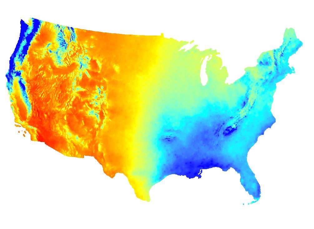
5 Future Climate
6 Future Climate
7 Future Climate
8 Future Climate
9 Future Climate
10 Future Climate
11 Future Climate
12 The problem of pattern and scale in ecology Simon A. Levin 1992

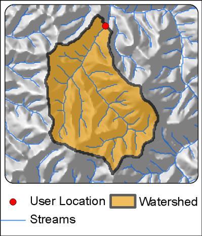
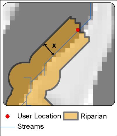
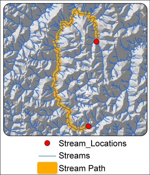
13 Spatial Scales Point Watershed Riparian Local Local-watershed Local-riparian Linear Path Stream Path Point-based data from a location s X, Y coordinates.
14 Spatial Scales Point Watershed Riparian Local Local-watershed Local-riparian Linear Path Stream Path All geographic areas that drain into a userdefined location
15 Spatial Scales Point Watershed Riparian Local Local-watershed Local-riparian Linear Path Stream Path Areas within a location s watershed AND within a user-defined distance (x) from streams.
16 Spatial Scales Point Watershed Riparian Local Local-watershed Local-riparian Linear Path Stream Path Areas within a location s watershed AND within a user-defined distance (x) from streams.
 of a user-defined location.")
17 Spatial Scales Point Watershed Riparian Local Local-watershed Local-riparian Linear Path Stream Path Areas within a user-defined radius (x) of a user-defined location.
18 Spatial Scales Point Watershed Riparian Local Local-watershed Local-riparian Linear Path Stream Path Areas within a location s local zone AND within its watershed.
19 Spatial Scales Point Watershed Riparian Local Local-watershed Local-riparian Linear Path Stream Path Areas within a location s local zone AND within its watershed.
20 Spatial Scales Point Watershed Riparian Local Local-watershed Local-riparian Linear Path Stream Path Buffered (x) stream path between all pairwise combinations of user-provided locations.
 stream path between all pairwise combinations of user-provided")
21 Spatial Scales Point Watershed Riparian Local Local-watershed Local-riparian Linear Path Stream Path Buffered (x) stream path between all pairwise combinations of user-provided locations.
22 Geodata Crawler Centralized national geodatabase & Automated multi-scale data crawler


23 Geodata Crawler Centralized national geodatabase & Automated multi-scale data crawler Python scripting with ESRI ArcGIS

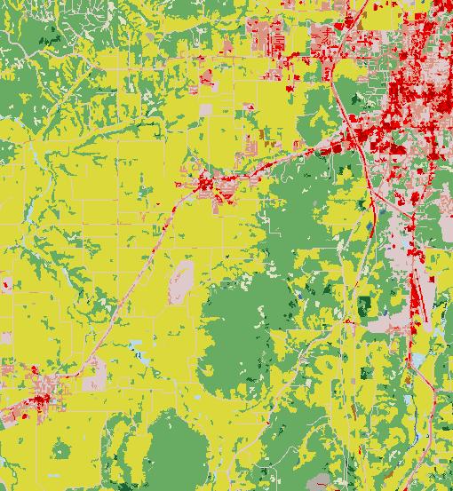
24 1. User-provided Locations
25 2. User-provided Boundary
26 3. Variable Selection Human population within 5 km radius Avg. January rainfall in watershed % forest in upstream riparian zone within 100 m of streams

27 Automated Sample Area Delineation & Data Collection Drainage Area: 926 sq km Forest Cover: 215 sq km Population: 482 people January Rainfall: 6 cm Avg. Terrain Slope: 3.2 degrees
28 Research Applications Species Distribution Modeling Sulphur Springs diving beetle Hydrological Modeling Mapping natural flow regimes & flow alteration Path analysis Gene flow among bluehead sucker populations in the Colorado River basin
29 Species Distribution Modeling

30 Sulphur Springs diving beetle Collaborators: Scott Longing & Pablo Bacon Endemic species of concern Headwater specialist 83 sample locations o Presence/absence Habitat associations at multiple spatial scales Heterosternuta sulphuria Predictive model
 Avg./Max. Terrain Slope Avg./Max. Stream Channel Slope Human population density Road density Riparian (50-800m buffer)")
31 Sulphur Springs diving beetle Landscape Characteristics of Interest: Watershed Area % Forest % Canopy Cover % Urban % Impervious Surfaces % Agriculture Watershed Local-watershed (200m-2km radius) Avg./Max. Terrain Slope Avg./Max. Stream Channel Slope Human population density Road density Riparian (50-800m buffer)
32 Bayesian Information Criteria (BIC) Effects of urbanization at multiple spatial scales Multi-model comparison with logistic regression Site Radius (meters)
33 Forested Riparian Buffers Non-parametric Multiplicative Regression McCune 2011, McCune & Medford 2004 Forest Cover in 100 m Riparian Zone Low Med High
34 Predicted Occurrences Maxent Presence-only modeling Phillips 2006
35 Predicted Occurrences Maxent Presence-only modeling Phillips 2006 R Package: BIOMOD Thuiller et al BIOMOD - a platform for ensemble forecasting of species distributions. Ecography.

36 Predicted Occurrences Maxent Presence-only modeling Phillips 2006 hydrology? population connectivity?
37 Hydrological Modeling
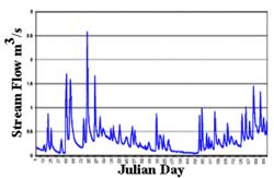
 67 reference streams with USGS gauges Collaborators: Dan Magoulick & Scott Longing Predict natural flow")
38 Mapping Natural Flow Regimes 7 natural flow regimes in Arkansas region (Leasure et al., in review) 67 reference streams with USGS gauges Collaborators: Dan Magoulick & Scott Longing Predict natural flow at un-gauged and disturbed streams

39 Landscape-Climate Flow Regime PRECIP SOIL

40 Predicted Natural Flow Regimes Random Forests Classification Breiman ,000 stream segments Predict natural flow regime Error Rate = 37%
41 Assessing Hydrologic Alteration Carlisle et al Random Forest to predict expected natural conditions (E) Gauge data to measure observed current conditions (O) O/E to measure flow alteration
42 Path Analysis & Animal Movements


43 Gene flow among bluehead sucker populations Collaborators: Michael & Marlis Douglas Bluehead Sucker Catostomis discobolus Microsat loci: 16 Specimens: 1092 Locations: 39
44 Barriers to Gene Flow??
45 No barrier = Similar allele freq.
46 Barrier = Dissimilar allele freq.


47 Fst Dissimilarity Matrix Fst
48 Map Fst to Stream Segments StreamTree (Kalinowski 2007) Fst Fst Fst Fst Fst Fst
49 Landscape/segment Fst/segment Fst Fst Fst Fst Fst Fst

50 Map Gene Flow Resistance Gene flow resistance Red = High Green = Low
51 Multi-scale Analysis as an Interdisciplinary Bridge
52 Hydrology Habitat Suitability Population Connectivity
53 Hydrology Population Connectivity Habitat Suitability
54 Hydrology Population Connectivity Habitat Suitability
55 Hydrology Future Climate Future Climate Future Climate Population Connectivity Habitat Suitability
56 Hydrology Population Connectivity Habitat Suitability
57 Hydrology Future Climate Population Connectivity Habitat Suitability
58 Hydrology Population Connectivity Habitat Suitability
59 Strategies Going Forward Big data from GIS & remote sensing Automated multi-scale data collection Contemporary modeling tools Multi-model inference Machine learning Ensemble forecasting Hierarchical Bayesian models*

60 Questions?
StreamStats: Delivering Streamflow Information to the Public. By Kernell Ries
 StreamStats: Delivering Streamflow Information to the Public By Kernell Ries U.S. Department of the Interior U.S. Geological Survey MD-DE-DC District 410-238-4317 kries@usgs.gov StreamStats Web Application
Assessing Michigan s Biological diversity. Michigan Natural Features Inventory MSU Extension
 Assessing Michigan s Biological diversity John Paskus,, Amy Derosier,, Edward Schools, and Helen Enander Michigan Natural Features Inventory MSU Extension Goal Provide scientifically based information
Spatial units (Levels 0 and 1)
") Spatial units (Levels 0 and 1) Project: Advancing the SEEA Experimental Ecosystem Accounting Overview: Spatial units 1. Learning objectives 2. Level 1: Presentation & group exercise Spatial units (10m
Spatial units (Levels 0 and 1) Project: Advancing the SEEA Experimental Ecosystem Accounting Overview: Spatial units 1. Learning objectives 2. Level 1: Presentation & group exercise Spatial units (10m
06/04/2015. Overview: Spatial units. Advancing the SEEA Experimental Ecosystem Accounting Spatial units (Level 1)
") Advancing the SEEA Experimental Ecosystem Accounting Spatial units (Level 1) Advancing the SEEA-EEA Project Overview: Spatial units 1. Learning objectives 2. Level 1: Presentation & group exercise Spatial
Advancing the SEEA Experimental Ecosystem Accounting Spatial units (Level 1) Advancing the SEEA-EEA Project Overview: Spatial units 1. Learning objectives 2. Level 1: Presentation & group exercise Spatial
Opportunities to Improve Ecological Functions of Floodplains and Reduce Flood Risk along Major Rivers in the Puget Sound Basin
 Opportunities to Improve Ecological Functions of Floodplains and Reduce Flood Risk along Major Rivers in the Puget Sound Basin Christopher Konrad, US Geological Survey Tim Beechie, NOAA Fisheries Managing
Welcome to NetMap Portal Tutorial
 Welcome to NetMap Portal Tutorial Potential Applications What Can you do with the Portal? At least 25 things! 1) Locate the best potential fish habitats. 2) Identify biological hotspots. 3) Map floodplain
Basin characteristics
 Basin characteristics From hydrological processes at the point scale to hydrological processes throughout the space continuum: point scale à river basin The watershed characteristics (shape, length, topography,
Dan Miller + Kelly Burnett, Kelly Christiansen, Sharon Clarke, Lee Benda. GOAL Predict Channel Characteristics in Space and Time
 Broad-Scale Models Dan Miller + Kelly Burnett, Kelly Christiansen, Sharon Clarke, Lee Benda GOAL Predict Channel Characteristics in Space and Time Assess Potential for Fish Use and Productivity Assess
A GIS-based Approach to Watershed Analysis in Texas Author: Allison Guettner
 Texas A&M University Zachry Department of Civil Engineering CVEN 658 Civil Engineering Applications of GIS Instructor: Dr. Francisco Olivera A GIS-based Approach to Watershed Analysis in Texas Author:
A Comprehensive Inventory of the Number of Modified Stream Channels in the State of Minnesota. Data, Information and Knowledge Management.
 A Comprehensive Inventory of the Number of Modified Stream Channels in the State of Minnesota Data, Information and Knowledge Management Glenn Skuta Environmental Analysis and Outcomes Division Minnesota
Hydrologic and Hydraulic Analyses Using ArcGIS
 Hydrologic and Hydraulic Analyses Using ArcGIS Two day training class Overview ArcGIS and Arc Hydro provide strong foundation for support of hydrologic and hydraulic (H&H) analyses. This two-day course
Geo-spatial Analysis for Prediction of River Floods
 Geo-spatial Analysis for Prediction of River Floods Abstract. Due to the serious climate change, severe weather conditions constantly change the environment s phenomena. Floods turned out to be one of
CAUSES FOR CHANGE IN STREAM-CHANNEL MORPHOLOGY
 CAUSES FOR CHANGE IN STREAM-CHANNEL MORPHOLOGY Chad A. Whaley, Department of Earth Sciences, University of South Alabama, MobileAL, 36688. E-MAIL: caw408@jaguar1.usouthal.edu The ultimate goal of this
Building a Spatial Framework for the Analysis of Benthic Fauna Along the River Network of Switzerland
 Building a Spatial Framework for the Analysis of Benthic Fauna Along the River Network of Switzerland Lehmann 1 A., S., Stucki 2 P. and Gonseth 3 Y. 1 University of Geneva, 2 private consultancy, 3 CSCF
Watershed Delineation in GIS Environment Rasheed Saleem Abed Lecturer, Remote Sensing Centre, University of Mosul, Iraq
 Watershed Delineation in GIS Environment Rasheed Saleem Abed Lecturer, Remote Sensing Centre, University of Mosul, Iraq Abstract: The management and protection of watershed areas is a major issue for human
CE 394K.3 GIS in Water Resources Midterm Quiz Fall There are 5 questions on this exam. Please do all 5. They are of equal credit.
 Name: CE 394K.3 GIS in Water Resources Midterm Quiz Fall 2000 There are 5 questions on this exam. Please do all 5. They are of equal credit. 1. The ArcView Geographic Information System can display different
The Refugia Concept: Using Watershed Analysis to Prioritize Salmonid Habitat for Conservation and Restoration
 The Refugia Concept: Using Watershed Analysis to Prioritize Salmonid Habitat for Conservation and Restoration Christopher May Battelle & UW Cumulative Impacts of Urbanization Landscape Alterations Loss
The Road to Data in Baltimore
 Creating a parcel level database from high resolution imagery By Austin Troy and Weiqi Zhou University of Vermont, Rubenstein School of Natural Resources State and local planning agencies are increasingly
USING HYPERSPECTRAL IMAGERY
 USING HYPERSPECTRAL IMAGERY AND LIDAR DATA TO DETECT PLANT INVASIONS 2016 ESRI CANADA SCHOLARSHIP APPLICATION CURTIS CHANCE M.SC. CANDIDATE FACULTY OF FORESTRY UNIVERSITY OF BRITISH COLUMBIA CURTIS.CHANCE@ALUMNI.UBC.CA
Introduction Fluvial Processes in Small Southeastern Watersheds
 Introduction Fluvial Processes in Small Southeastern Watersheds L. Allan James Scott A. Lecce Lisa Davis Southeastern Geographer, Volume 50, Number 4, Winter 2010, pp. 393-396 (Article) Published by The
Development and Land Use Change in the Central Potomac River Watershed. Rebecca Posa. GIS for Water Resources, Fall 2014 University of Texas
 Development and Land Use Change in the Central Potomac River Watershed Rebecca Posa GIS for Water Resources, Fall 2014 University of Texas December 5, 2014 Table of Contents I. Introduction and Motivation..4
Distinct landscape features with important biologic, hydrologic, geomorphic, and biogeochemical functions.
 1 Distinct landscape features with important biologic, hydrologic, geomorphic, and biogeochemical functions. Have distinguishing characteristics that include low slopes, well drained soils, intermittent
How Do Human Impacts and Geomorphological Responses Vary with Spatial Scale in the Streams and Rivers of the Illinois Basin?
 How Do Human Impacts and Geomorphological Responses Vary with Spatial Scale in the Streams and Rivers of the Illinois Basin? Bruce Rhoads Department of Geography University of Illinois at Urbana-Champaign
Spatial Units (Level 1)
") Spatial Units (Level 1) Project: Advancing the SEEA Experimental Ecosystem Accounting Overview: Spatial Units 1. Learning objectives 2. Review of Level 0 (5m) 3. Level 1 (Compilers): Presentation & group
Spatial Units (Level 1) Project: Advancing the SEEA Experimental Ecosystem Accounting Overview: Spatial Units 1. Learning objectives 2. Review of Level 0 (5m) 3. Level 1 (Compilers): Presentation & group
GIS Enabled Automated Culvert Design
 GIS Enabled Automated Culvert Design ASHTON GREER PH.D. STUDENT, THE UNIVERSITY OF ALABAMA DR. ANDREW GRAETTINGER, LEAH CLIFTON, ZACHARY WILBANKS, BRADFORD WILSON Outline Culvert Background Project Objectives
Using Remote Sensing to Analyze River Geomorphology
 Using Remote Sensing to Analyze River Geomorphology Seeing Water from Space Workshop August 11 th, 2015 George Allen geoallen@unc.edu Rivers impact: Geology Ecology Humans The atmosphere River Geomorphology
Using ArcGIS for Hydrology and Watershed Analysis:
 Using ArcGIS 10.2.2 for Hydrology and Watershed Analysis: A guide for running hydrologic analysis using elevation and a suite of ArcGIS tools Anna Nakae Feb. 10, 2015 Introduction Hydrology and watershed
Potential Restorable Wetlands (PRWs):
:") ASWM Webinar Sept. 17, 2014 Potential Restorable Wetlands (PRWs): Working definition: wetland hydrology and soils minus presently mapped wetlands for the re-establishment of wetlands Hydric Soil Query
ASWM Webinar Sept. 17, 2014 Potential Restorable Wetlands (PRWs): Working definition: wetland hydrology and soils minus presently mapped wetlands for the re-establishment of wetlands Hydric Soil Query
Vulnerability assessment of Sta.Rosa-Silang subwatershed using SWAT
 Vulnerability assessment of Sta.Rosa-Silang subwatershed using SWAT Damasa B. Magcale-Macandog, Charles Gunay and Milben A. Bragais Institute of Biological Sciences, University of the Philippines Los Baños,
Existing NWS Flash Flood Guidance
 Introduction The Flash Flood Potential Index (FFPI) incorporates physiographic characteristics of an individual drainage basin to determine its hydrologic response. In flash flood situations, the hydrologic
Hydrologic Modelling of the Upper Malaprabha Catchment using ArcView SWAT
 Hydrologic Modelling of the Upper Malaprabha Catchment using ArcView SWAT Technical briefs are short summaries of the models used in the project aimed at nontechnical readers. The aim of the PES India
HYDROLOGIC AND WATER RESOURCES EVALUATIONS FOR SG. LUI WATERSHED
 HYDROLOGIC AND WATER RESOURCES EVALUATIONS FOR SG. LUI WATERSHED 1.0 Introduction The Sg. Lui watershed is the upper part of Langat River Basin, in the state of Selangor which located approximately 20
Hydrologic Engineering Applications of Geographic Information Systems
 Hydrologic Engineering Applications of Geographic Information Systems Davis, California Objectives: The participant will acquire practical knowledge and skills in the application of GIS technologies for
REMOTE SENSING AND GEOSPATIAL APPLICATIONS FOR WATERSHED DELINEATION
 REMOTE SENSING AND GEOSPATIAL APPLICATIONS FOR WATERSHED DELINEATION Gaurav Savant (gaurav@engr.msstate.edu) Research Assistant, Department of Civil Engineering, Lei Wang (lw4@ra.msstate.edu) Research
MISSOURI LiDAR Stakeholders Meeting
 MISSOURI LiDAR Stakeholders Meeting East-West Gateway June 18, 2010 Tim Haithcoat Missouri GIO Enhanced Elevation Data What s different about it? Business requirements are changing.fast New data collection
Appendix D. Model Setup, Calibration, and Validation
 . Model Setup, Calibration, and Validation Lower Grand River Watershed TMDL January 1 1. Model Selection and Setup The Loading Simulation Program in C++ (LSPC) was selected to address the modeling needs
GRAPEVINE LAKE MODELING & WATERSHED CHARACTERISTICS
 GRAPEVINE LAKE MODELING & WATERSHED CHARACTERISTICS Photo Credit: Lake Grapevine Boat Ramps Nash Mock GIS in Water Resources Fall 2016 Table of Contents Figures and Tables... 2 Introduction... 3 Objectives...
Monitoring Headwater Streams for Landscape Response to
 Monitoring Headwater Streams for Landscape Response to Climate Change Matthew Connor, PhD Connor nvironmental, nc. www.oe-i.com icom Healdsburg, California verview Headwater stream geomorphology Response
Automated Identification and Characterization of Landforms on Mars
 Automated Identification and Characterization of Landforms on Mars Tomasz F. Stepinski Lunar and Planetary Institute Collaborators: Wei Luo Students: Brain Bue Ian Molloy Erik Urbach Michael Mendenhall
13 Watershed Delineation & Modeling
 Module 4 (L12 - L18): Watershed Modeling Standard modeling approaches and classifications, system concept for watershed modeling, overall description of different hydrologic processes, modeling of rainfall,
Relief Camp Tool Using GIS
 Relief Camp Tool Using GIS MAYANK SINGH SAKLA 1, JANKI ADHVARYU 2 1 M.TECH GEOMATICS STUDENT, CEPT UNIVERSITY 2 M.TECH GEOMATICS STUDENT, CEPT UNIVERSITY K L CAMPUS UNIVERSITY AREA NAVARANG PURA AHMEDABAD
MODELING RIPARIAN ZONES UTILIZING DEMS, FLOOD HEIGHT DATA, DIGITAL SOIL DATA AND NATIONAL WETLAND INVENTORY VIA GIS INTRODUCTION
 MODELING RIPARIAN ZONES UTILIZING DEMS, FLOOD HEIGHT DATA, DIGITAL SOIL DATA AND NATIONAL WETLAND INVENTORY VIA GIS Sinan Abood, PhD Candidate Ann Maclean, Professor School of Forest Resources and Environmental
Graduate Courses Meteorology / Atmospheric Science UNC Charlotte
 Graduate Courses Meteorology / Atmospheric Science UNC Charlotte In order to inform prospective M.S. Earth Science students as to what graduate-level courses are offered across the broad disciplines of
Governing Rules of Water Movement
 Governing Rules of Water Movement Like all physical processes, the flow of water always occurs across some form of energy gradient from high to low e.g., a topographic (slope) gradient from high to low
5/4/2017 Fountain Creek. Gage Analysis. Homework 6. Clifton, Cundiff, Pour, Queen, and Zey CIVE 717
 5/4/2017 Fountain Creek Gage Analysis Homework 6 Clifton, Cundiff, Pour, Queen, and Zey CIVE 717 Introduction: The CIVE 717 class members, Nate Clifton, Susan Cundiff, Ali Reza Nowrooz Pour, Robbie Queen
Diagnostic Geomorphic Methods for Understanding Future Behavior of Lake Superior Streams What Have We Learned in Two Decades?
 Diagnostic Geomorphic Methods for Understanding Future Behavior of Lake Superior Streams What Have We Learned in Two Decades? Faith Fitzpatrick USGS WI Water Science Center, Middleton, WI fafitzpa@usgs.gov
LAND CHANGE MODELER SOFTWARE FOR ARCGIS
 LAND CHANGE MODELER SOFTWARE FOR ARCGIS The Land Change Modeler is revolutionary land cover change analysis and prediction software which also incorporates tools that allow you to analyze, measure and
ENMTools: a toolbox for comparative studies of environmental niche models
 Ecography 33: 607611, 2010 doi: 10.1111/j.1600-0587.2009.06142.x # 2010 The Authors. Journal compilation # 2010 Ecography Subject Editor: Thiago Rangel. Accepted 4 September 2009 ENMTools: a toolbox for
Improvement of the National Hydrography Dataset for Parts of the Lower Colorado Region and Additional Areas of Importance to the DLCC
 Improvement of the National Hydrography Dataset for Parts of the Lower Colorado Region and Additional Areas of Importance to the DLCC Carlos Reyes-Andrade California State University, Northridge September
Extreme Phenomena in Dobrogea - Floods and Droughts
 Extreme Phenomena in Dobrogea - Floods and Droughts PhD eng. Carmen Maftei Ovidius University of Constanta (Partner no 4) OUTLINES Introduction Study area Drought Floods Conclusion What is the problem?
MODULE 7 LECTURE NOTES 5 DRAINAGE PATTERN AND CATCHMENT AREA DELINEATION
 MODULE 7 LECTURE NOTES 5 DRAINAGE PATTERN AND CATCHMENT AREA DELINEATION 1. Introduction Topography of the river basin plays an important role in hydrologic modelling, by providing information on different
WATER RESOURCES AND URBANIZATION Vulnerability and Adaptation in the Context of Climate Variability
 WATER RESOURCES AND URBANIZATION Vulnerability and Adaptation in the Context of Climate Variability Krishna Balakrishnan LA 221: Class Project Problem Statement My PhD research focuses on the vulnerability
Watershed concepts for community environmental planning
 Purpose and Objectives Watershed concepts for community environmental planning Dale Bruns, Wilkes University USDA Rural GIS Consortium May 2007 Provide background on basic concepts in watershed, stream,
A SIMPLE GIS METHOD FOR OBTAINING FLOODED AREAS
 A SIMPLE GIS METHOD FOR OBTAINING FLOODED AREAS ROMAN P., I. 1, OROS C., R. 2 ABSTRACT. A simple GIS method for obtaining flooded areas. This paper presents a method for obtaining flooded areas near to
ENVS S102 Earth and Environment (Cross-listed as GEOG 102) ENVS S110 Introduction to ArcGIS (Cross-listed as GEOG 110)
 ENVS S110 Introduction to ArcGIS (Cross-listed as GEOG 110)") ENVS S102 Earth and Environment (Cross-listed as GEOG 102) 1. Describe the fundamental workings of the atmospheric, hydrospheric, lithospheric, and oceanic systems of Earth 2. Explain the interactions
ENVS S102 Earth and Environment (Cross-listed as GEOG 102) 1. Describe the fundamental workings of the atmospheric, hydrospheric, lithospheric, and oceanic systems of Earth 2. Explain the interactions
Geospatial Data, Services, and Products. National Surveying, mapping and geospatial conference
 Geospatial Data, Services, and Products Federal Programs -- USDA NRCS National Surveying, mapping and geospatial conference March 15, 2016 NRCS Applications using Geosaptial Products & Services Field
USING A GEOGRAPHIC INFORMATION SYSTEM TO PREDICT FLOW DURATION CURVES AT UNGAGED STREAM SITES IN GUAM
 USING A GEOGRAPHIC INFORMATION SYSTEM TO PREDICT FLOW DURATION CURVES AT UNGAGED STREAM SITES IN GUAM Dr. Leroy F. Heitz lheitz@triton.uog.edu Dr. Shahram Khosrowpanah khosrow@triton.uog.edu Water and
Summary Description Municipality of Anchorage. Anchorage Coastal Resource Atlas Project
 Summary Description Municipality of Anchorage Anchorage Coastal Resource Atlas Project By: Thede Tobish, MOA Planner; and Charlie Barnwell, MOA GIS Manager Introduction Local governments often struggle
Atlas of the Upper Gila River Watershed
 Atlas of the Upper Gila River Watershed Katie Banister, David Chan, Jessica M. Driscoll, Christopher Fullerton, Aaron Lien and Kelly Mott Lacroix January 2014 The University of Arizona Water Resources
Influence of spatial variation in precipitation on artificial neural network rainfall-runoff model
 Hydrology Days 212 Influence of spatial variation in precipitation on artificial neural network rainfall-runoff model André Dozier 1 Department of Civil and Environmental Engineering, Colorado State University
Managing Grizzly Bear Data. ESRI 2009 International User Conference, San Diego, California Presented by: Julie Duval, July 15, 2009
 Managing Grizzly Bear Data ESRI 2009 International User Conference, San Diego, California Presented by: Julie Duval, July 15, 2009 Agenda 1) Overview of the Foothills Research Institute 2) Grizzly Bear
Logistic Regression for Distribution Modeling
 Logistic Regression for Distribution Modeling GIS5306 GIS Applications in Environmental Systems Presented by: Andrea Palmiotto John Perry Theory Familiar Territory Linear Regression Relevant Assumptions
Appendix I: The Summit-at-Snoqualmie Master Development Plan Proposal FEIS Physical and Biological Resource Data Tables
 Appendix I: The Summit-at-Snoqualmie Master Development Plan Proposal FEIS Physical and Biological Resource Data Tables DPC Tables Rationale for DPC Analysis Parameters for 7 th Field Watersheds for The
Introduction to Geographic Information Systems (GIS): Environmental Science Focus
: Environmental Science Focus") Introduction to Geographic Information Systems (GIS): Environmental Science Focus September 9, 2013 We will begin at 9:10 AM. Login info: Username:!cnrguest Password: gocal_bears Instructor: Domain: CAMPUS
Introduction to Geographic Information Systems (GIS): Environmental Science Focus September 9, 2013 We will begin at 9:10 AM. Login info: Username:!cnrguest Password: gocal_bears Instructor: Domain: CAMPUS
Section 4: Model Development and Application
 Section 4: Model Development and Application The hydrologic model for the Wissahickon Act 167 study was built using GIS layers of land use, hydrologic soil groups, terrain and orthophotography. Within
CHAPTER V WATERSHED CHARACTERIZATION USING GIS
 61 CHAPTER V WATERSHED CHARACTERIZATION USING GIS 5.1 GENERAL: In this chapter, introduction to watershed characterization and analysis has been presented in the first part. Methodology to compute important
Development of GIS Tools to Optimize Identification of Road Segments Prone to Flood Damage
 A Report from the University of Vermont Transportation Research Center Development of GIS Tools to Optimize Identification of Road Segments Prone to Flood Damage Final Report TRC Report 15-005 September
Figure 0-18: Dendrogeomorphic analysis of streambank erosion and floodplain deposition (from Noe and others, 2015a)
") Appendix 9A: Stream to River During the development of the Phase 6 Watershed Model, multiple methods for determining coefficients were often attempted. In some cases, the methods are averaged or otherwise
Appendix 9A: Stream to River During the development of the Phase 6 Watershed Model, multiple methods for determining coefficients were often attempted. In some cases, the methods are averaged or otherwise
Spatial Units, Scaling and Aggregation (Level 1) October 2017
 October 2017") Spatial Units, Scaling and Aggregation (Level 1) October 2017 Overview: Spatial Units 1. Learning objectives 2. Review of Level 0 (5m) 3. Level 1 (Compilers): Presentation & group exercise Spatial units
Spatial Units, Scaling and Aggregation (Level 1) October 2017 Overview: Spatial Units 1. Learning objectives 2. Review of Level 0 (5m) 3. Level 1 (Compilers): Presentation & group exercise Spatial units
Lecture 3. Data Sources for GIS in Water Resources
 Lecture 3 Data Sources for GIS in Water Resources GIS in Water Resources Spring 2015 http://www.data.gov/ 1 USGS GIS data for Water http://water.usgs.gov/maps.html Watersheds of the US 2-digit water resource
4. GIS Implementation of the TxDOT Hydrology Extensions
 4. GIS Implementation of the TxDOT Hydrology Extensions A Geographic Information System (GIS) is a computer-assisted system for the capture, storage, retrieval, analysis and display of spatial data. It
GIS in Water Resources Midterm Exam Fall 2012 There are five questions on this exam. Please do all five.
 Page 1 of 6 Name: Key GIS in Water Resources Midterm Exam Fall 2012 There are five questions on this exam. Please do all five. Question 1 (a) You have worked with the location of Utah State University
CR AAO Bridge. Dead River Flood & Natural Channel Design. Mitch Koetje Water Resources Division UP District
 CR AAO Bridge Dead River Flood & Natural Channel Design Mitch Koetje Water Resources Division UP District Old County Road AAO Bridge Map courtesy of Marquette County Silver Lake Basin McClure Basin
Chapter 6. Fundamentals of GIS-Based Data Analysis for Decision Support. Table 6.1. Spatial Data Transformations by Geospatial Data Types
 Chapter 6 Fundamentals of GIS-Based Data Analysis for Decision Support FROM: Points Lines Polygons Fields Table 6.1. Spatial Data Transformations by Geospatial Data Types TO: Points Lines Polygons Fields
ROAD SEDIMENT ASSESSMENT & MODELING: KOOTENAI-FISHER TMDL PLANNING AREA ROAD GIS LAYERS & SUMMARY STATISTICS
 ROAD SEDIMENT ASSESSMENT & MODELING: KOOTENAI-FISHER TMDL PLANNING AREA ROAD GIS LAYERS & SUMMARY STATISTICS Prepared by: ATKINS Water Resources Group 820 North Montana Avenue Helena, MT 59601 November
Stream Correction for Local Government GIS
 Stream Correction for Local Government GIS A Practical Guide and Introduction Nicholas McKenny Penn State Adviser: James O'Brien 1/16 Presentation Outline Existing Situation Solution, Goals, & Hopes Guide
A Temporal Hydrologic Database for Rapidly Changing Landscapes
 A Temporal Hydrologic Database for Rapidly Changing Landscapes Using Mt. St. Helens in Washington as a Pilot Site Adam Mosbrucker Geog 575 BACKGROUND: Client / User U.S. Geological Survey Cascades Volcano
The Yellow River Initiative: The Birth of a System Approach to Challenges Facing the Everglades of the North
 The Yellow River Initiative: The Birth of a System Approach to Challenges Facing the Everglades of the North Robert Barr and Siavash Beik 2016 INAFSM Annual Conference Belterra Conference Center, Indiana
Each basin is surrounded & defined by a drainage divide (high point from which water flows away) Channel initiation
 Channel initiation") DRAINAGE BASINS A drainage basin or watershed is defined from a downstream point, working upstream, to include all of the hillslope & channel areas which drain to that point Each basin is surrounded &
DRAINAGE BASINS A drainage basin or watershed is defined from a downstream point, working upstream, to include all of the hillslope & channel areas which drain to that point Each basin is surrounded &
USGS Hydrography Overview. May 9, 2018
 + 1 USGS Hydrography Overview May 9, 2018 + 2 The National Geospatial Program Provides the geospatial baseline of the Nation s topography, natural landscape and built environment through The National Map,
Application of Geographical Information System (GIS) tools in watershed analysis
 tools in watershed analysis") Application of Geographical Information System (GIS) tools in watershed analysis Paritosh Gupta 1, Damanjit S Minhas 2, Rajendra M Tamhane 1, A K Mookerjee 2 1.ESRI India New Delhi 2. LEA Associates South
Application of Geographical Information System (GIS) tools in watershed analysis Paritosh Gupta 1, Damanjit S Minhas 2, Rajendra M Tamhane 1, A K Mookerjee 2 1.ESRI India New Delhi 2. LEA Associates South
The Iowa Watershed Approach
 A vision for a more resilient Iowa Larry Weber Director, IIHR Hydroscience & Engineering Larry-weber@uiowa.edu 1 Kickoff Iowa Grant meeting Award: follow-up $96,887,177 2 How can we stay informed about
MESO SCALE 5/3/2018. Outline: 1.Introduction 2.Fractal Dimension 3.Geographic Information Systems (GIS) 4.Remote Sensing (RS) 5.
 4.Remote Sensing (RS) 5.") 5/3/218 Dr. Kaswanto Thursday, May 3, 218 www.kaswanto.staff.ipb.ac.id It is important to immediately clarify that the study of the landscape requires metrics but also additional tools like Databases,
5/3/218 Dr. Kaswanto Thursday, May 3, 218 www.kaswanto.staff.ipb.ac.id It is important to immediately clarify that the study of the landscape requires metrics but also additional tools like Databases,
CE 394K/CEE6440 GIS in Water Resources Fall 2018 Final Exam Solution
 CE 394K/CEE6440 GIS in Water Resources Fall 2018 Final Exam Solution 3. Austin Population The figure below shows two feature classes, one being the extent of the 1:24,000 Austin East topographic map and
Locating Potential Archaeology Sites in Aomori, Japan Using Predicative and Maximum Entropy Modeling
 Locating Potential Archaeology Sites in Aomori, Japan Using Predicative and Maximum Entropy Modeling William Goldby LA 221 Tessa Beach Amna Alruheili Final White Paper 13 May 2014 Locating Potential Archaeology
Preliminary Calculation of Landscape Integrity in West Virginia Based on Distance from Weighted Disturbances
 Preliminary Calculation of Landscape Integrity in West Virginia Based on Distance from Weighted Disturbances Michael Dougherty and Elizabeth Byers Technical Support and Wildlife Diversity Units, Wildlife
Flood Forecasting Tools for Ungauged Streams in Alberta: Status and Lessons from the Flood of 2013
 Flood Forecasting Tools for Ungauged Streams in Alberta: Status and Lessons from the Flood of 2013 John Pomeroy, Xing Fang, Kevin Shook, Tom Brown Centre for Hydrology, University of Saskatchewan, Saskatoon
Workshops funded by the Minnesota Environment and Natural Resources Trust Fund
 Workshops funded by the Minnesota Environment and Natural Resources Trust Fund Conservation Applications of LiDAR Data Workshops funded by: Minnesota Environment and Natural Resources Trust Fund Presented
USING 3D GIS TO ASSESS ENVIRONMENTAL FLOOD HAZARDS IN MINA
 King Fahd University of Petroleum & Minerals College of Environmental Design Geographical Information system USING 3D GIS TO ASSESS ENVIRONMENTAL FLOOD HAZARDS IN MINA Prepared by : Ali AL-Zahrani OUTLINE
Streamflow, Sediment, and Nutrient Simulation of the Bitterroot Watershed using SWAT
 Streamflow, Sediment, and Nutrient Simulation of the Bitterroot Watershed using SWAT by Dr. Michael Van Liew Montana Department of Environmental Quality Helena, Montana, USA Site Map of SWAT Watersheds
Vegetation and Wildlife Habitat Mapping Study in the Upper and Middle Susitna Basin Study Plan Section 11.5
 (FERC No. 14241) Vegetation and Wildlife Habitat Mapping Study in the Upper and Middle Susitna Basin Study Plan Section 11.5 Initial Study Report Part C: Executive Summary and Section 7 Prepared for Prepared
STREUVER FIDELCO CAPPELLI, LLC YONKERS DOWNTOWN DEVELOPMENT PHASE 1. DRAFT ENVIRONMENTAL IMPACT STATEMENT For: PALISADES POINT
 STREUVER FIDELCO CAPPELLI, LLC YONKERS DOWNTOWN DEVELOPMENT PHASE 1 DRAFT ENVIRONMENTAL IMPACT STATEMENT For: PALISADES POINT Prepared by: PAULUS, SOKOLOWSKI & SARTOR STORMWATER MANAGEMENT 1. Methodology
What is a watershed or landscape perspective?
 What is a watershed or landscape perspective? -remove sediment -add sediment -add wood, riparian manipulation -alter (engineer) channel/floodplain morphology -restore/abandon roads You are here What is
Gully erosion and associated risks in the Tutova basin Moldavian Plateau
 Landform Analysis, Vol. 17: 193 197 (2011) Gully erosion and associated risks in the Tutova basin Moldavian Plateau University Alexandru Ioan Cuza of Iasi, Department of Geography, Romania, e-mail: catiul@yahoo.com
Stochastic Hydrology. a) Data Mining for Evolution of Association Rules for Droughts and Floods in India using Climate Inputs
 Data Mining for Evolution of Association Rules for Droughts and Floods in India using Climate Inputs") Stochastic Hydrology a) Data Mining for Evolution of Association Rules for Droughts and Floods in India using Climate Inputs An accurate prediction of extreme rainfall events can significantly aid in policy
Stochastic Hydrology a) Data Mining for Evolution of Association Rules for Droughts and Floods in India using Climate Inputs An accurate prediction of extreme rainfall events can significantly aid in policy
Assignment 1. Measuring River Characteristics- Vernon Creek. Applied Fluvial Geomorphology Field Techniques EESc 435
 Assignment 1 Measuring River Characteristics- Vernon Creek Applied Fluvial Geomorphology Field Techniques EESc 435 Amanda Jardine 30100093 Jaime McDonald 14177083 Erica Massey 50870088 April 28, 2012 Introduction
Drainage Analysis. Appendix F
 Drainage Analysis Appendix F Golden View Drive Elizabeth Street LMORE CREEK Ricky Road Rabbit Creek Road LITTLE RABBIT CREEK East 156th Avenue MOA Project #10-026 Golden View Drive Intersection
Remote Sensing and Geospatial Application for Wetlands Mapping, Assessment, and Mitigation
 Remote Sensing and Geospatial Application for Wetlands Mapping, Assessment, and Mitigation Hydrology Soils MSU Seminar Series Remote Sensing and Geospatial Applications September 4, 2002 Vegetation NEPA
GIS Techniques for Floodplain Delineation. Dean Djokic
 GIS Techniques for Floodplain Delineation Dean Djokic (ddjokic@esri.com) Content What is a floodplain? How to get a floodplain? What can GIS do for floodplain modeling? Simple GIS techniques for floodplain
VT EPSCoR Streams Project: Highlights & Future Plans. Streams Project Symposium April 27, 2009
 VT EPSCoR Streams Project: Highlights & Future Plans Streams Project Symposium April 27, 2009 What is the Streams Project? Collaborative effort by high schools, colleges and community partners around the