City Models to Explore the Impact of New Urban Infrastructures
|
|
|
- Augustus Campbell
- 5 years ago
- Views:
Transcription
1 June 29 th 2016 City Models to Explore the Impact of New Urban Infrastructures Michael My Main Themes Can We Predict the Impact of New Infrastructure? Bottom Up Impacts, Better Data, Poor Theory, Unforeseen Effects, Unintended Consequences City Models: What Do We Already Have? Models were simple and are now complicated or complex Complexity and Cities: Bigness, Scale We need models to capture effects across many scales/times Building A Model For Everywhere & Everyone Our model is a LUTI model for England and Wales A Prototype: A Demonstration 1
2 Can We Predict the Impact of New Infrastructure? Bottom Up Impacts cities work from the bottom up top down planning is brute force and needs to be tempered Poor Theory we do not have good theory and this is getting less good due to increasing complexity of cities Impact is all about unforeseen effects we do not know what these are and they work at all scales in space and time Examples of fine spatial scale and time Unintended Consequences City Models: What Do We Already Have? Models were simple and are now complicated or complex. We have many many models from many many perspectives wrt cities but they are not integrated or even coordinated We do not have good tested and validated models and we may never have such models there may always be a plurality of models for different purposes of prediction and impact analysis Our most operational models tend to be urban land use transport models LUTI models and they tend to be static not dynamics and of modest spatial scale they do not treat time and space in sufficient detail - 2
3 Complexity and Cities: Bigness, Scale We need models to capture effects across many scales/times - the problem is that bigness and scale are crucial to working out impacts Basically our models have always struggled to get fine spatial scales and time scales. To introduce this let us look briefly at the models that we have been building These are models for Greater London and we began a few years ago with a limited area the GLA and we have expanded out Building A Model For Everywhere & Everyone Our model is a LUTI model for England and Wales. Here is our model ORIGINS DESTINATIONS t = 1 ORIGINS Employment E i (t) T ij (t) DESTINATIONS S ji (t) P j (t) Population Economy Demography 3


 i & v i")
 d ij")
 d ji")


4 t = 1 ORIGINS ORIGINS Employment Wages and Revenues we i (t) i & v i DESTINATIONS T ij (t) d ij DESTINATIONS S ji (t) d ji Economy P j (t) p j House Population prices Demography What about other flows, than people or money, materials and information? 4


5 We have built this model for Greater London and used it to test various what if type statements about impact of new transport routes and so on 5


6 6
7 A Prototype Demo for England &Wales 7


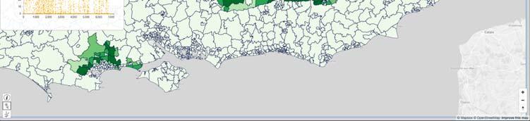
8 Flow Maps Bar Maps 8
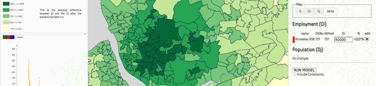
9 An Idea of the Model: Essentially a couple of nested spatial interactiondiscrete choice-like models one for residential, the other for the retail sector, cross sectional static T k ij O i k P j T ij S O k j k k i P k j obs k k Dj exp( dij ) obs k D exp( d ) j W obs j obs W k k S j j k exp( d k j k ij ) k exp( d k j ) k 1, k 2, k 3 road, rail, bus The Web and the Desktop: Users are also Data We are building this aggregate LUTI model of the UK well E&W at present we will add Scotland before long which is of the nature we have been implying Without going into details, the model takes a few seconds to run it will take a lot longer when finished as we will add sectors and of course the number of big data we have to hold in RAM might be very large currently we need to hold 3 x 2 such 52 million sized matrices we may need to go up to multiples of this and that will involve a lot of packing and moving in and out of core, I think 9
10 But the real issue is users if our model is this large, and we have many users, then our data problem is exploded by the users Our big data is our original and predicted data from the model, times the number of users. Why are users data? Well because they are using data differently they are making their own predictions and thus scaling up the data. We could have one model for each user but we don t know who the users are? We thus want them to access this on the web... Let me see if I can demo it from here in fact I am hoping you have some web links if you haven t then you can do it on your phone and then it really does look dreadful The Web and the Desktop: Users are also Data Here is a block diagram of how we are currently organising things Client-1 Client-2 Client-3. Client-n Server(s) Model on server side; Maps on the client side Can we reverse this? Not really the matrices are too slow to download to client? We also can t assume the client is fast enough for computation. Also we cannot predict the client and we can t assume enough memory in the client Frankly at this point, I am out of my depth 10


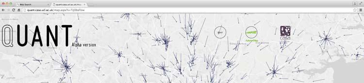
11 So Let Me Give You A Demo Of What We Are Doing The web link is For those who want to try it out There is always a caveat emptor with demo models like this. We are building it as a demo for the FCC and it not supposed to be a flashy app or anything it is something that local authority planners and consultants might use as a resource along with many other complementary decision support tools 11


12 12


13 13


14 14


15 15


16 16


17 17


18 18


19 19


20 20


21 21


22 22


23 23


24 Conclusions and Next Steps We need to do many things and the most important is working with decision-makers people who will use these tools. Our view is that the process of translating these models into tools is one which is lengthy and involved more involved than building these models per se and we have only just begun to recognise these We need to develop fine scale multi level models The extent to which these models needs to be known by those who use them is still a crucial issue in fact a more important issue than ever we realised before. 24
25 June 30 th 2016 Thanks Acknowledgements CASA: Richard Milton, Lyz Cortes, FCC: Ewen Gibb, Scott Cain, Borkur Sigurbjornsson
Land Use Transportation Interaction Models
 July 27- August 2, 2014 Land Use Transportation Interaction Models Michael Batty m.batty@ucl.ac.uk @michaelbatty http://www.complexcity.info/ http://www.spatialcomplexity.info/ Outline Preliminary Ideas:
Land Use Transportation Interaction Models
 Opening Lecture 2 September 4 th 2014 Land Use Transportation Interaction Models Michael Batty m.batty@ucl.ac.uk @michaelbatty http://www.complexcity.info/ http://www.spatialcomplexity.info/ Outline Preliminary
Integrated Modelling of the Spatial Impacts of Climate Change In Greater London
 Megacities, Vulnerability and Global Climate Change: FAPESP: City of São Paulo, July 20 th 22 nd 2009 Integrated Modelling of the Spatial Impacts of Climate Change In Greater London Michael Batty University
The Tyndall Cities Integrated Assessment Framework
 The Tyndall Cities Integrated Assessment Framework Alistair Ford 1, Stuart Barr 1, Richard Dawson 1, Jim Hall 2, Michael Batty 3 1 School of Civil Engineering & Geosciences and Centre for Earth Systems
Measuring connectivity in London
 Measuring connectivity in London OECD, Paris 30 th October 2017 Simon Cooper TfL City Planning 1 Overview TfL Connectivity measures in TfL PTALs Travel time mapping Catchment analysis WebCAT Current and
Designing smart & Resilient cities:
 Designing smart & Resilient cities: How can Egyptian cities learn from an emerging global practice On the Cuspof Change Professor Samer Bagaeen FRICS MRTPI FRSA AoU 1. GLOBAL CHALLENGES POPULATION GROWTH,
Extending the Focus of Urban Modelling Tools
 A Meeting sponsored by ASU, UCL, Newcastle Universities and the British Consulate, 21-23 May 2010 Extending the Focus of Urban Modelling Tools Michael Batty University College London m.batty@ucl.ac.uk
A Land Use Transport Model for Greater London:
 Spatio-Temporal Analysis of Network Data and Road Developments Launch Event Workshop UCL Monday 18 May 2009 A Land Use Transport Model for Greater London: With Applications to an Integrated Assessment
OFWIM 2017 Annual Conference What Does Web GIS Really Mean for Fish and Wildlife Agencies?
 Content Open Mapping OFWIM 2017 Annual Conference What Does Web GIS Really Mean for Fish and Wildlife Agencies? Imagery Spatial Analysis Mike Bialousz, Esri 3D Data Exploration Real-Time Apps Visualization
Delivering Met to the Military User
 Delivering Met to the Military User Andy Kirkman Met Office Defence Business Manager ECMWF MOS Workshop - November 2007 Crown copyright 2006 Page 1 Delivering Met to the Military User This Presentation
Simple Spatial Growth Models The Origins of Scaling in Size Distributions
 Lectures on Spatial Complexity 17 th 28 th October 2011 Lecture 3: 21 st October 2011 Simple Spatial Growth Models The Origins of Scaling in Size Distributions Michael Batty m.batty@ucl.ac.uk @jmichaelbatty
COSMIC: COmplexity in Spatial dynamic
 COSMIC: COmplexity in Spatial dynamic MICs 9 10 November, Brussels Michael Batty University College London m.batty@ucl.ac.uk http://www.casa.ucl.ac.uk/ Outline The Focus of the Pilot The Partners: VU,
Smart Cities & Big Data How We Can Make Cities More Resilient
 July 15 th 19 th 2012 University College Dublin Smart Cities & Big Data How We Can Make Cities More Resilient Michael Batty m.batty@ucl.ac.uk @jmichaelbatty http://www.spatialcomplexity.info/ http://www.casa.ucl.ac.uk/
Manchester City Region: The case for agglomeration economies. Steve Gibbons Henry Overman Alessandra Tucci
 Manchester City Region: The case for agglomeration economies Steve Gibbons Henry Overman Alessandra Tucci Objectives Explain agglomeration economies Review of existing evidence Primary evidence on role
Exploring Digital Welfare data using GeoTools and Grids
 Exploring Digital Welfare data using GeoTools and Grids Hodkinson, S.N., Turner, A.G.D. School of Geography, University of Leeds June 20, 2014 Summary As part of the Digital Welfare project [1] a Java
ECNU Writing Workshop, October 28 th, Urban Models: The Decline of Theory, The Rise of Big Data and the Fragmentation of Applications
 ECNU Writing Workshop, October 28 th, 2012 CAMUSS Urban Models: The Decline of Theory, The Rise of Big Data and the Fragmentation of Applications Michael Batty University College London m.batty@ucl.ac.uk
Infrastructure to Explore Geographic Systems through Models and Maps
 Exemplar 1: GeoVUE Then GENeSIS (GENerative e SocIalScience) Infrastructure to Explore Geographic Systems through Models and Maps Michael Batty University College London m.batty@ucl.ac.uk http://www.casa.ucl.ac.uk/
1 A Science of Cities
 5 th February 2014 1 A Science of Cities Michael Batty m.batty@ucl.ac.uk @jmichaelbatty http://www.complexcity.info/ http://www.casa.ucl.ac.uk/ Centre Centre for Advanced for Advanced Spatial Spatial Analysis,
TOWARDS THE DEVELOPMENT OF A MONITORING SYSTEM FOR PLANNING POLICY Residential Land Uses Case study of Brisbane, Melbourne, Chicago and London
 TOWARDS THE DEVELOPMENT OF A MONITORING SYSTEM FOR PLANNING POLICY Residential Land Uses Case study of Brisbane, Melbourne, Chicago and London Presented to CUPUM 12 July 2017 by Claire Daniel Urban Planning/Data
Connectivity. RTPI Scotland Annual Conference Edinburgh, 2nd October 2018
 Connectivity Tom Rye, Professor and Director, Transport Research Institute (TRI), Edinburgh Napier University, Scotland, UK (with input from Nina Plevnik, TRI) RTPI Scotland Annual Conference Edinburgh,
Transport Planning in Large Scale Housing Developments. David Knight
 Transport Planning in Large Scale Housing Developments David Knight Large Scale Housing Developments No longer creating great urban spaces in the UK (Hall 2014) Transport Planning Transport planning processes
The Governance of Land Use
 The planning system The Governance of Land Use United Kingdom Levels of government and their responsibilities The United Kingdom is a unitary state with three devolved governments in Northern Ireland,
Getting On the Same Page and Parcel
 Getting On the Same Page and Parcel Local flair is a valued and cherished quality of small Vermont towns and cities. The Agency of Natural Resources works daily with town officials and local committee
Spatial Planning & Climate Change
 Spatial Planning & Climate Change A GRIP Approach Joseph Scott, Glasgow & Clyde Valley Strategic Development Plan Authority, Scotland Today s presentation Context Spatial Planning & Climate Change Exploring
Can Public Transport Infrastructure Relieve Spatial Mismatch?
 Can Public Transport Infrastructure Relieve Spatial Mismatch? Evidence from Recent Light Rail Extensions Kilian Heilmann University of California San Diego April 20, 2015 Motivation Paradox: Even though
INTELLIGENT CITIES AND A NEW ECONOMIC STORY CASES FOR HOUSING DUNCAN MACLENNAN UNIVERSITIES OF GLASGOW AND ST ANDREWS
 INTELLIGENT CITIES AND A NEW ECONOMIC STORY CASES FOR HOUSING DUNCAN MACLENNAN UNIVERSITIES OF GLASGOW AND ST ANDREWS THREE POLICY PARADOXES 16-11-08 1. GROWING FISCAL IMBALANCE 1. All orders of government
Cities, AI, Design, & the Future Can Artificial Intelligence Improve Design Intelligence?
 March 27 th 28 Cities, AI, Design, & the Future Can Artificial Intelligence Improve Design Intelligence? Michael Batty m.batty@ucl.ac.uk @jmichaelbatty http://www.spatialcomplexcity.info/ http://www.casa.ucl.ac.uk/
Secondary Towns and Poverty Reduction: Refocusing the Urbanization Agenda
 Secondary Towns and Poverty Reduction: Refocusing the Urbanization Agenda Luc Christiaensen and Ravi Kanbur World Bank Cornell Conference Washington, DC 18 19May, 2016 losure Authorized Public Disclosure
Unit 1, Lesson 3 What Tools and Technologies Do Geographers Use?
 Unit 1, Lesson 3 What Tools and Technologies Do Geographers Use? Geographers use a variety of tools and technologies in investigating geographic questions. Maps and globes both represent the earth, but
Joint MISTRAL/CESI lunch workshop 15 th November 2017
 MISTRAL@Newcastle Joint MISTRAL/CESI lunch workshop 15 th November 2017 ITRC at Newcastle ITRC at Newcastle MISTRAL at Newcastle New approach to infrastructure data management to open-up analytics, modelling
Lecture 19: Common property resources
 Lecture 19: Common property resources Economics 336 Economics 336 (Toronto) Lecture 19: Common property resources 1 / 19 Introduction Common property resource: A resource for which no agent has full property
The Role of Urban Planning and Local SDI Development in a Spatially Enabled Government. Faisal Qureishi
 The Role of Urban Planning and Local SDI Development in a Spatially Enabled Government Faisal Qureishi 1 Introduction A continuous increase in world population combined with limited resources has lead
Cadcorp Introductory Paper I
 Cadcorp Introductory Paper I An introduction to Geographic Information and Geographic Information Systems Keywords: computer, data, digital, geographic information systems (GIS), geographic information
Section 20: Arrow Diagrams on the Integers
 Section 0: Arrow Diagrams on the Integers Most of the material we have discussed so far concerns the idea and representations of functions. A function is a relationship between a set of inputs (the leave
Note on Transportation and Urban Spatial Structure
 Note on Transportation and Urban Spatial Structure 1 By Alain Bertaud, Washington, ABCDE conference, April 2002 Email: duatreb@msn.com Web site: http://alain-bertaud.com/ http://alainbertaud.com/ The physical
How is public transport performing in Australia
 How is public transport performing in Australia CILTA Moving People Thursday 17 March 2011 Professor Corinne Mulley Institute of Transport and Logistics Studies Outline Measuring performance Australia
accessibility accessibility by-pass bid-rent curve bridging point administrative centre How easy or difficult a place is to reach.
 accessibility accessibility How easy or difficult a place is to reach. How easy or difficult it is to enter a building. administrative centre bid-rent curve The function of a town which is a centre for
Spatial Analysis using Vector GIS THE GOAL: PREPARATION:
 PLAN 512 GIS FOR PLANNERS Department of Urban and Environmental Planning University of Virginia Fall 2006 Prof. David L. Phillips Spatial Analysis using Vector GIS THE GOAL: This tutorial explores some
Introduction to ArcGIS Maps for Office. Greg Ponto Scott Ball
 Introduction to ArcGIS Maps for Office Greg Ponto Scott Ball Agenda What is Maps for Office? Platform overview What are Apps for the Office? ArcGIS Maps for Office features - Visualization - Geoenrichment
Data driven approaches to Urban Planning Experience from Derry/Londonderry
 Data driven approaches to Urban Planning Experience from Derry/Londonderry Anna Rose RTPI Belfast 11 th of September 1 June 26 07:47AM 2 The value of the City The space of the city is a theatre: playing
Estimating Transportation Demand, Part 2
 Transportation Decision-making Principles of Project Evaluation and Programming Estimating Transportation Demand, Part 2 K. C. Sinha and S. Labi Purdue University School of Civil Engineering 1 Estimating
Key Questions: Where are Alaska s volcanoes? How many volcanoes are found in Alaska?
 Key Questions: Where are Alaska s volcanoes? How many volcanoes are found in Alaska? Unit 1 Grade levels: At a basic level, these activities are appropriate for grades 3-6; with suggested extensions for
Year 11: Possible Extended Questions. 1. Using examples explain why it is difficult to predict future population growth.
 Year 11: Possible Extended Questions Population Dynamics 1. Using examples explain why it is difficult to predict future population growth. 2. Explain why the future growth of world population is hard
Data Aggregation with InfraWorks and ArcGIS for Visualization, Analysis, and Planning
 Data Aggregation with InfraWorks and ArcGIS for Visualization, Analysis, and Planning Stephen Brockwell President, Brockwell IT Consulting, Inc. Join the conversation #AU2017 KEYWORD Class Summary Silos
Map reading made easy
 Map reading made easy 1 1. What is a map? A map is simply a drawing or picture (in 2-D) of a landscape or area of a country (in 3-D). It could be anything from a sketch map for a visitor to find your school
CITY OF CEDAR FALLS D O W N T O W N PA R K I N G S T U D Y P U B L I C W O R K S H O P D E C E M B E R 5,
 CITY OF CEDAR FALLS D O W N T O W N PA R K I N G S T U D Y P U B L I C W O R K S H O P D E C E M B E R 5, 2 0 1 8 PA R K I N G S T U D Y S C O P E O F W O R K Parking study methodology Parking inventory
C/W 4/9/ Sheffield = Steel. 2. Detroit = Car Manufacturing. 3. Bangalore = Business Process Outsourcing. 4. Leeds = Textiles
 C/W Qu:Why did 5 steel workers become strippers? Aim: To describe how the function of major UK cities has changed over time and suggest reasons for this. Starter: What industry are the following cities
Unit 1, Lesson 2. What is geographic inquiry?
 What is geographic inquiry? Unit 1, Lesson 2 Understanding the way in which social scientists investigate problems will help you conduct your own investigations about problems or issues facing your community
Web GIS Patterns and Practices
 FedGIS Conference February 24 25, 2016 Washington, DC Web GIS Patterns and Practices Philip Heede Jay Theodore Witt Mathot Web GIS Transformation of the ArcGIS Platform Desktop Apps Web Maps Web Scenes
Map reading made easy
 Map reading made easy 1. What is a map? A map is simply a drawing or picture (in 2-D) of a landscape or area of a country (in 3-D). It could be anything from a sketch map for a visitor to find your school
1 Impact Evaluation: Randomized Controlled Trial (RCT)
") Introductory Applied Econometrics EEP/IAS 118 Fall 2013 Daley Kutzman Section #12 11-20-13 Warm-Up Consider the two panel data regressions below, where i indexes individuals and t indexes time in months:
Introductory Applied Econometrics EEP/IAS 118 Fall 2013 Daley Kutzman Section #12 11-20-13 Warm-Up Consider the two panel data regressions below, where i indexes individuals and t indexes time in months:
Web GIS: Architectural Patterns and Practices. Shannon Kalisky Philip Heede
 Web GIS: Architectural Patterns and Practices Shannon Kalisky Philip Heede Web GIS Transformation of the ArcGIS Platform Desktop Apps Server GIS Web Maps Web Scenes Layers Web GIS Transformation of the
Map reading made easy
 Map reading made easy Maps can be great fun and they can lead you to all sorts of discoveries. They can help you get to know an area really well, because they pinpoint interesting places that are often
Business Model for sustainable regional development by tourism
 Business Model for sustainable regional development by tourism Why EuroVeloPark Banat? Steps to Success Action proposal 1. Drawing of the Basis Map 2. Data Acquisition, POIs, etc. 3. Printed Map and Distribution
Accessibility as an Instrument in Planning Practice. Derek Halden DHC 2 Dean Path, Edinburgh EH4 3BA
 Accessibility as an Instrument in Planning Practice Derek Halden DHC 2 Dean Path, Edinburgh EH4 3BA derek.halden@dhc1.co.uk www.dhc1.co.uk Theory to practice a starting point Shared goals for access to
Healthy Cities. Lecture 4 Planning and Regeneration, Sustainable and Healthy. Opening Address
 Healthy Cities Lecture 4 Planning and Regeneration, Sustainable and Healthy Opening Address Suzanne Wylie Director of Health and Environmental Services, Belfast City Council Belfast The Past The Present
The Building Blocks of the City: Points, Lines and Polygons
 The Building Blocks of the City: Points, Lines and Polygons Andrew Crooks Centre For Advanced Spatial Analysis andrew.crooks@ucl.ac.uk www.gisagents.blogspot.com Introduction Why use ABM for Residential
GIS for the Beginner on a Budget
 GIS for the Beginner on a Budget Andre C. Bally, RLA, GIS Coordinator, Harris County Public Infrastructure Department Engineering Division This presentation, GIS for Beginners on a Budget. will briefly
6.080 / Great Ideas in Theoretical Computer Science Spring 2008
 MIT OpenCourseWare http://ocw.mit.edu 6.080 / 6.089 Great Ideas in Theoretical Computer Science Spring 2008 For information about citing these materials or our Terms of Use, visit: http://ocw.mit.edu/terms.
Land Use in the context of sustainable, smart and inclusive growth
 Land Use in the context of sustainable, smart and inclusive growth François Salgé Ministry of sustainable development France facilitator EUROGI vice president AFIGéO board member 1 Introduction e-content+
Working with ArcGIS Online
 Esri International User Conference San Diego, CA Technical Workshops July 12, 2011 Working with ArcGIS Online Bern Szukalski, Deane Kensok Topics for this Session ArcGIS Online Overview ArcGIS Online Content
Reimaging GIS: Geographic Information Society. Clint Brown Linda Beale Mark Harrower Esri
 Reimaging GIS: Geographic Information Society Clint Brown Linda Beale Mark Harrower Esri 8 billion = Number of basemap requests per month on AGOL 14,000 = Unique requests per second 12,000 = New Items
THE FIVE THEMES OF GEOGRAPHY U N I T O N E
 THE FIVE THEMES OF GEOGRAPHY U N I T O N E FIVE THEMES OF GEOGRAPHY 1. Location 2. Place 3. Human-Environment Interaction 4. Movement 5. Region LOCATION LOCATION The position that something occupies Earth
Land Use Modeling at ABAG. Mike Reilly October 3, 2011
 Land Use Modeling at ABAG Mike Reilly michaelr@abag.ca.gov October 3, 2011 Overview What and Why Details Integration Use Visualization Questions What is a Land Use Model? Statistical relationships between
Cloud Shadow IT Survey Results
 Cloud Shadow IT Survey Results *Preview 12 April 2016 Demographics 250 IT decision makers (ITDMs) and 250 business decision makers (BDMs) were interviewed in March 2016, split in the following ways...
What is GIS and How Can It Help Me?
 esri European User Conference Madrid 2011 What is GIS and How Can It Help Me? Jaime Nieves Ignacio Vázquez esri spain «Knowing where things are, and why, is essential to rational decision making.» Jack
Deviant Behavior in Monetary Economics
 Deviant Behavior in Monetary Economics Lawrence Christiano and Yuta Takahashi July 26, 2018 Multiple Equilibria Standard NK Model Standard, New Keynesian (NK) Monetary Model: Taylor rule satisfying Taylor
Subject: Geography Scheme of Work: B1 to B6 Mastery tiles. Term: Autumn/Spring/Summer
 Subject: Geography Scheme of Work: B1 to B6 Mastery tiles Term: Autumn/Spring/Summer Topic / Unit(s) Overview / Context Introduction to geography. An introduction to geography including basic map skills
Smart Cities, Data and Big Data
 Urban and Regional Planning for Urban Design October 2015 Smart Cities, Data and Big Data Michael Batty m.batty@ucl.ac.uk @jmichaelbatty http://www.complexcity.info/ http://www.spatialcomplexity.info/
Community Engagement in Cultural Routes SiTI Higher Institute on Territorial Systems for Innovation Sara Levi Sacerdotti
 Transnational Workshop Wroclaw, 7th-8th December 2016 Community Engagement in Cultural Routes SiTI Higher Institute on Territorial Systems for Innovation Sara Levi Sacerdotti levi@siti.polito.it TAKING
Portal for ArcGIS: An Introduction. Catherine Hynes and Derek Law
 Portal for ArcGIS: An Introduction Catherine Hynes and Derek Law Agenda Web GIS pattern Product overview Installation and deployment Configuration options Security options and groups Portal for ArcGIS
GIS Building Communities beyond National Borders (Building Successful Spatial Data Infrastructures) Nick Land, ESRI Europe
 Nick Land, ESRI Europe") GIS Building Communities beyond National Borders (Building Successful Spatial Data Infrastructures) Nick Land, ESRI Europe UK worst flooding in the last 60 years 350,000 households without drinking water
GIS Building Communities beyond National Borders (Building Successful Spatial Data Infrastructures) Nick Land, ESRI Europe UK worst flooding in the last 60 years 350,000 households without drinking water
M. Saraiva* 1 and J. Barros 1. * Keywords: Agent-Based Models, Urban Flows, Accessibility, Centrality.
 The AXS Model: an agent-based simulation model for urban flows M. Saraiva* 1 and J. Barros 1 1 Department of Geography, Birkbeck, University of London, 32 Tavistock Square, London, WC1H 9EZ *Email: m.saraiva@mail.bbk.ac.uk
Demystifying ArcGIS Online. Karen Lizcano Esri
 Demystifying ArcGIS Online Karen Lizcano Esri An Integrated Web GIS Platform Desktop Web Device Powered by Services Managed via Portal Access from any Device Portal Server Online Content and Services ArcGIS
Subject: Note on spatial issues in Urban South Africa From: Alain Bertaud Date: Oct 7, A. Spatial issues
 Page 1 of 6 Subject: Note on spatial issues in Urban South Africa From: Alain Bertaud Date: Oct 7, 2009 A. Spatial issues 1. Spatial issues and the South African economy Spatial concentration of economic
SA Geospatial Analysis Platform (GAP) Methodology*, collaborators & data sources
 Methodology*, collaborators & data sources") SA Geospatial Analysis Platform (GAP) Methodology*, collaborators & data sources Mesoframe CSIR, dti, the Presidency & GTZ Demarcation of South Africa into a grid of 50 Km 2 mesozones, nested within important
SA Geospatial Analysis Platform (GAP) Methodology*, collaborators & data sources Mesoframe CSIR, dti, the Presidency & GTZ Demarcation of South Africa into a grid of 50 Km 2 mesozones, nested within important
WORD CHECK UP. Destruction. Ground-breaking. Instigated
 DAY101 Half of life on Earth gone since humans arrived Humans represent a tiny fraction of all life on Earth, but are responsible for the destruction of 83 per cent of all wild mammals and half of our
You don t have to look too deeply to see how chemistry affects your life.
 Chapter 1: Page 0 Chapter 1: Page 1 You don t have to look too deeply to see how chemistry affects your life. Every breath you take, every meal you eat, everything has something to do with the interaction
Understanding the Spatial Effects of High Speed Rail
 Transport and Spatial Planning Transport Planning Society and RTPI 23 November 2015 Finsbury Square, London Understanding the Spatial Effects of High Speed Rail Professor John Worthington Commissioner,
ASTRO 114 Lecture Okay. What we re going to discuss today are what we call radiation laws. We ve
 ASTRO 114 Lecture 15 1 Okay. What we re going to discuss today are what we call radiation laws. We ve been spending a lot of time talking about laws. We ve talked about gravitational laws, we ve talked
P, NP, NP-Complete. Ruth Anderson
 P, NP, NP-Complete Ruth Anderson A Few Problems: Euler Circuits Hamiltonian Circuits Intractability: P and NP NP-Complete What now? Today s Agenda 2 Try it! Which of these can you draw (trace all edges)
City sustainability: a transport perspective a journey continues
 Sustainable Development, Vol. 2 833 City sustainability: a transport perspective a journey continues K. Doust1,2, C. Wang1 & T. Doust2 1 Research Centre for Integrated Transport Innovation (rciti), University
Managing Growth: Integrating Land Use & Transportation Planning
 Managing Growth: Integrating Land Use & Transportation Planning Metro Vancouver Sustainability Community Breakfast Andrew Curran Manager, Strategy June 12, 2013 2 Integrating Land Use & Transportation
What s wrong with sprawl? The urgent need for cost benefit analyses of modern urban growth patterns. Jacy Gaige
 What s wrong with sprawl? The urgent need for cost benefit analyses of modern urban growth patterns. Jacy Gaige Urban Econ 245 Professor Charles Becker Literature Review 1 Urban is hip. Bikes, messenger
WATER AND THE CITY IAIN WHITE THE NATURAL AND BUILT ENVIRONMENT SERIES
 CMYK www.routledge.com 9 780415 553339 As a vital human need water has been absolutely critical to decisions as to where cities originate, how much they grow and the standard of living of the inhabitants.
GIS-Based Analysis of the Commuting Behavior and the Relationship between Commuting and Urban Form
 GIS-Based Analysis of the Commuting Behavior and the Relationship between Commuting and Urban Form 1. Abstract A prevailing view in the commuting is that commuting would reconstruct the urban form. By
INSPIRE in the context of EC Directive 2002/49/EC on Environmental Noise
 INSPIRE in the context of EC Directive 2002/49/EC on Environmental Noise Simon Shilton Acustica Ltd, United Kingdom Nigel Jones Extrium Ltd, United Kingdom About the Authors www.acustica.co.uk Acoustics
The Role of Transitways in Our Region s Economic Competitiveness. The 23rd CTS Annual Research Conference St. Paul, MN May 23, 2012
 The Role of Transitways in Our Region s Economic Competitiveness The 23rd CTS Annual Research Conference St. Paul, MN May 23, 2012 1 2 Twin Cities Competitive Clusters 3 Competitive Clusters interconnected
Exploit your geodata to enable smart cities and countries
 Exploit your geodata to enable smart cities and countries Carsten Rönsdorf, Head of Advisory Services Middle East Practice Manager Future Cities, standards and 3D 24 November 2014 Importance of Standards
Riocan Centre Study Area Frontenac Mall Study Area Kingston Centre Study Area
 OVERVIEW the biggest challenge of the next century (Dunham Jones, 2011). New books are continually adding methods and case studies to a growing body of literature focused on tackling this massive task.
Travel behavior of low-income residents: Studying two contrasting locations in the city of Chennai, India
 Travel behavior of low-income residents: Studying two contrasting locations in the city of Chennai, India Sumeeta Srinivasan Peter Rogers TRB Annual Meet, Washington D.C. January 2003 Environmental Systems,
Shaping Your Neighbourhood
 Shaping Your Neighbourhood Building a Core Sustainable Neighbourhood Action Plan Nov. 25 & 26, 2006 Welcome! Peter Russell Planner, Holland Barrs Planning Group Inc. Role in this project: Work with the
User Requirements Gathering for a National 3D Mapping Product in the United Kingdom
 User Requirements Gathering for a National 3D Mapping Product in the United Kingdom Session 4 EuroSDR/VOLTA SESSION: NMCAS I (3D GEOINFORMATION FOR NATIONAL AND CADASTRAL MAPPING AGENCIES I) th 13 3DGeoInfo
Lecture 7: Cellular Automata Modelling: Principles of Cell Space Simulation
 SCHOOL OF GEOGRAPHY Lecture 7: Cellular Automata Modelling: Principles of Cell Space Simulation Outline Types of Urban Models Again The Cellular Automata Approach: Urban Growth and Complexity Theory The
Lee County, Alabama 2015 Forecast Report Population, Housing and Commercial Demand
 Lee County, Alabama 2015 Forecast Report Population, Housing and Commercial Demand Thank you for purchasing this report, which contains forecasts of population growth, housing demand and demand for commercial
How to Characterize Solutions to Constrained Optimization Problems
 How to Characterize Solutions to Constrained Optimization Problems Michael Peters September 25, 2005 1 Introduction A common technique for characterizing maximum and minimum points in math is to use first
Lecture 7: Cellular Automata Modelling: Principles of Cell Space Simulation
 MRes in Advanced Spatial Analysis and Visualisation Lecture 7: Cellular Automata Modelling: Principles of Cell Space Simulation Outline Types of Urban Models Again The Cellular Automata Approach: Urban
YEAR 7 REVISION BOOKLET
 YEAR 7 REVISION BOOKLET Assessment checklist 1. To be able to define Geography. 2. Give examples of what we study in geography 3. Group what we study into the three major areas of geography 4. To be able
Forecasts from the Strategy Planning Model
 Forecasts from the Strategy Planning Model Appendix A A12.1 As reported in Chapter 4, we used the Greater Manchester Strategy Planning Model (SPM) to test our long-term transport strategy. A12.2 The origins
A Science of Cities. Models of Urban Form and Function. Michael
 July 27- August 2, 2014 A Science of Cities Models of Urban Form and Function Michael Batty m.batty@ucl.ac.uk @jmichaelbatty http://www.complexcity.info/ http://www.casa.ucl.ac.uk/ Centre Centre for Advanced