Lecture 7: Cellular Automata Modelling: Principles of Cell Space Simulation
|
|
|
- Sherilyn Greer
- 6 years ago
- Views:
Transcription


1 SCHOOL OF GEOGRAPHY Lecture 7: Cellular Automata Modelling: Principles of Cell Space Simulation
2 Outline Types of Urban Models Again The Cellular Automata Approach: Urban Growth and Complexity Theory The Structure of CA: Representation and Rules Different Model Applications The DUEM Model: Software and Applications Links to Urban Morphology Links to Agent Based Models: The Next Lecture If we have time, an example from West London
3 Types of Urban Models Again Land Use Transportation Models LUTI/LUTM dealing with location and interaction, transport and the urban economy, represented at a level of abstraction involving administrative rather than physical subdivisions of the city: generally cross sectional, comparative static. Top down. Cellular Automata Models (CA) dealing with urban growth sprawl, land development and land cover, represented at finer spatial scales defined by or detecting physical morphology, do not deal with explicit transportation; dynamic in time. Bottom up.
4 Microsimulation demographic and related rule based processes, individual based, dynamic, non spatial. Bottom up in intent, Top down in conception Land Cover Models (LUCC) which simulate vegetation cover, ecosystem properties, agriculture, as well as some urban. Agent Based Models (ABM MAS) a generic style of representation for individual based dynamics processes, such as movement of individuals and objects These classifications mix the substance of what is being modelled with methods for modelling: microsimulation, CA and ABM are methods, LUTI and LUCC are models of specific systems
5 The Cellular Automata Approach: Urban Growth and Complexity Theory Essentially CA models developed in the late 1980s early 1990s from at least three sources: bottom up thinking about systems in contrast to top down, concepts of emergence in particular related to morphology, GIS and raster based representation of activity layers To an extent, CA represented a simple logic of building such models first models built by geographers such as Waldo Tobler in the 1970s and 1980s but first urban models by myself, White and Engelen, and Clarke in the early 1990s.
6 These models have found favour in rapidly growing systems which are characterised by urban sprawl, like Phoenix. They have been quite inappropriately applied to non rapid growth cities where the focus is on redistribution. They are clearly not as widely applicable to urban systems as LUTI models. They have not been widely applied by municipalities as they do not contain explicit mechanisms for generating numerical forecasts that are demographically or economically based. Where they have been applied, they have been nested within wider schemes which involve coupling to LUTI, demographic and other models.
7 The Structure of CA: Representation and Rules To illustrate how CA works, we first define a grid of cells, ( or it could be irregular but to simplify we will assume a square grid) a neighbourhood around each cell which is composed of the nearest cells, a set of rules as to how what happens in the neighbourhood affects the development of the cell in question a set of states that each cell can take on i.e. developed or not developed an assumption of universality that all these features operate uniformly and universally
8 This defines a (cellular) automata machine that can be applied to all cells that define the system: i.e. each cell is an automata Some things to note: cells are irregular and not necessarily spatially adjacent. Neighbourhoods can be wider then those which are formed from nearest neighbours they could be formed as fields like interaction fields around a cell Strict CA are models whose rules work on neighbourhoods defined by nearest neighbours and exhibit emergence i.e. their operation is local giving rise to global pattern Cell space models can relax some or all of these rules
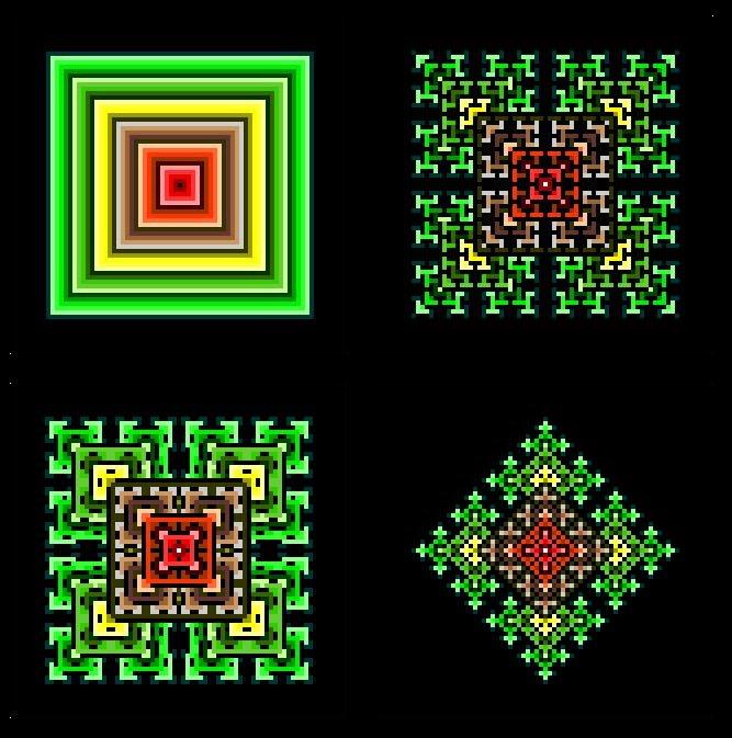
9 This is how a CA works defined on a square grid of cells with two states not developed and developed (a) (b) (c) The neighbourhood is composed of 8 cells around the central cell Place the neighbourhood over each cell on the grid. The rule says that if there is one or more cells developed (black) in the neighbourhood, then the cell is developed. If you keep on doing this for every cell, you get the diffusion from the central cell shown below.
10 These are strictly deterministic CA models and we can have different shaped local neighbourhoods composed of different combinations of cells e.g. (a) Moore (c) Extended Moore von Neumann (b) von Neumann
11 And we can have probabilistic fields defining neighbourhoods where there is a probability that a cells changes state where the probabilities might vary regularly reflecting say action at a distance principles e.g. We will now show some examples of how one can generate idealised patterns that illustrate emergence
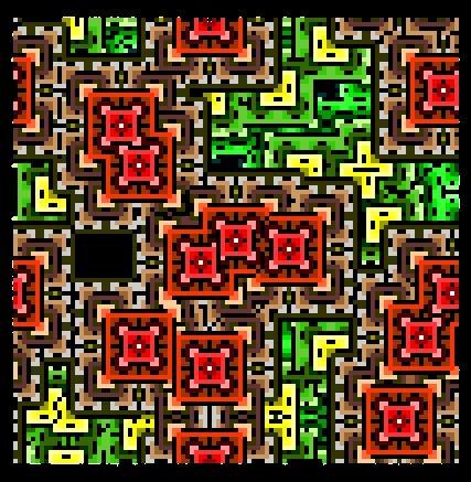
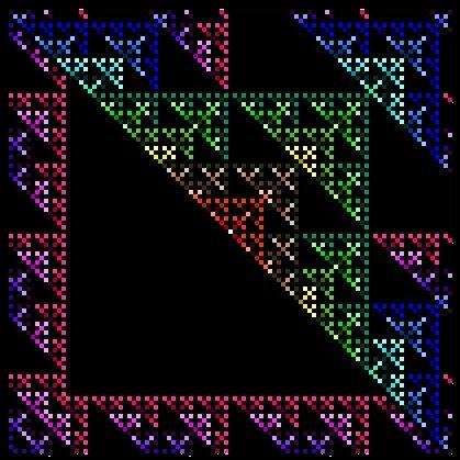
12 For example, for any cell {x,y}, if only one neighborhood cell either NW, SE, NE, or SW other than {x,y} is already developed, then cell {x,y} is developed according to the following neighborhood switching rule And changing There rules in various ways lead to many different patterns
13
14 For probabilistic rules, we can generate statistically self similar structures which look more like real city morphologies. For example, if any neighborhood cell other than {x,y} is already developed, then the field value p {x,y} is set & if p {x,y} > some threshold value, then the cell {x,y} is developed


15 Here are the constructions we have seen overlayed so you can see how neighbourhood rules make a distinct difference
16 Different Model Applications At least 12 groups around the world, probably more now developing these kinds of model White and Engelen, RIKS, Holland GeoDynamica, METROnamica Clarke, UCSB/NCGIA, USA SLEUTH Yeh and Li, Hong Kong Pearl River RS bias Wu/Webster Southampton/Cardiff urban economics Xie/Batty Ypsilanti/London, US/UK DUEM Cechinni/Viola Venice, Italy AUGH Rabino/Lombardi Milan/Turin, Italy NN Calibration Semboloni Florence, Italy links to traditional LU models Phin/Murray Brisbane/Adelaide, Aus visualization Portugali/Benenson Tel Aviv, Israel CITY models Various applications in INPE (Brazil), China (Beijing), Japan, Portugal, Taiwan, Canada, Haifa (Technion), Ascona, France (Pumain s group), Louvain la Neuve, Netherlands (ITC), JRC (Ispra+Dublin+RIKS), even at CASA Kiril Stanilov s model


17 Historical Examples from Abercrombie s book Town and Country Planning (1935)
18


19

20 Growth through time: Washington DC-Baltimore Las Vegas


21 You can download this software from our web site at

22 The DUEM Model: Software and Applications Now I can demonstrate this model which has been applied to the Detroit region. It is downloadable from our web site at


 Modeling Urban Dynamics Through GIS Based")
23 Before I do so, I will show some slides from some applications. There is a CEUS 1999 paper on this but the rudiments are included in my book referenced at the end. Batty, M., Xie, Y., and Sun, Z. (1999) Modeling Urban Dynamics Through GIS Based Cellular Automata, Computers, Environments and Urban Systems, 23, Duem.exe


24 Links to Urban Morphology To anticipate how this relate to form and scaling and related issues, let us look at a hierarchical scheme k=0 k=1 k=2 k=3
25 Links to Agent Based Models Now often CA is conflated merged with ABM but ABM is a distinct style of modelling it assumes many of the structures of CA but it poses active agents or objects who have a sense of purpose, who are autonomous in some senses, on the system. There are very few ABM models as such although there are some in traffic modelling like TRANSIMS and MATSIM and some in residential segregation based on Schelling s model A good summary is in Andrew Crook s blog:
26 The Next Lecture: References In the next lecture, I will talk about agent based models, specifically pedestrian models On CA modelling, there is a relatively simple and I hope intelligible article I wrote in 1997 in the Journal of the American Planning Association: Batty, M. (1997) Cellular Automata and Urban Form: A Primer, Journal of the American Planning Association, 63, This is on our web site
")

27 There is a lot to read on CA. More generally my book Cities and Complexity (MIT Press, Cambridge, MA, 2005) has a lot of general material and covers the DUEM model. A more focussed book is Liu, Y. (2008) Modelling Urban Development with Geographical Information Systems and Cellular Automata (CRC Press, Boca Raton, FL).
28 Questions?
Lecture 7: Cellular Automata Modelling: Principles of Cell Space Simulation
 MRes in Advanced Spatial Analysis and Visualisation Lecture 7: Cellular Automata Modelling: Principles of Cell Space Simulation Outline Types of Urban Models Again The Cellular Automata Approach: Urban
Session 4: Lecture 4: Cellular Automata. One and Two D D Automata and the Beginnings of ABM. Michael Batty
 Lectures on Complexity and Spatial Simulation Thursday, 14 March 2013 Session 4: Lecture 4: Cellular Automata One and Two D D Automata and the Beginnings of ABM Michael Batty m.batty@ucl.ac.uk @jmichaelbatty
ECNU Writing Workshop, October 28 th, Urban Models: The Decline of Theory, The Rise of Big Data and the Fragmentation of Applications
 ECNU Writing Workshop, October 28 th, 2012 CAMUSS Urban Models: The Decline of Theory, The Rise of Big Data and the Fragmentation of Applications Michael Batty University College London m.batty@ucl.ac.uk
Spatio-temporal dynamics of the urban fringe landscapes
 Spatio-temporal dynamics of the urban fringe landscapes Yulia Grinblat 1, 2 1 The Porter School of Environmental Studies, Tel Aviv University 2 Department of Geography and Human Environment, Tel Aviv University
The Building Blocks of the City: Points, Lines and Polygons
 The Building Blocks of the City: Points, Lines and Polygons Andrew Crooks Centre For Advanced Spatial Analysis andrew.crooks@ucl.ac.uk www.gisagents.blogspot.com Introduction Why use ABM for Residential
Towards a cellular automata based land-use transportation model
 Towards a cellular automata based land-use transportation model Nuno Norte Pinto * Department of Civil Engineering, University of Coimbra, Coimbra, Portugal António Pais Antunes Department of Civil Engineering,
Lecture 2: Modelling Histories: Types and Styles:
 SCHOOL OF GEOGRAPHY Lecture 2: Modelling Histories: Types and Styles: Urban Models defined, The Urban Modelling Timeline, What Kind of Cities, Examples of Three Model Types Outline Origins: Location Theory
A cellular automata model for the study of small-size urban areas
 Context and Motivation A cellular automata model for the study of small-size urban areas Centre de Política de Sòl i Valoracions Barcelona 23 January 2007 Nuno Norte Pinto School of Technology and Management
1 A Science of Cities
 5 th February 2014 1 A Science of Cities Michael Batty m.batty@ucl.ac.uk @jmichaelbatty http://www.complexcity.info/ http://www.casa.ucl.ac.uk/ Centre Centre for Advanced for Advanced Spatial Spatial Analysis,
MODELLING AND UNDERSTANDING MULTI-TEMPORAL LAND USE CHANGES
 MODELLING AND UNDERSTANDING MULTI-TEMPORAL LAND USE CHANGES Jianquan Cheng Department of Environmental & Geographical Sciences, Manchester Metropolitan University, John Dalton Building, Chester Street,
PROGRESS IN GEOGRAPHY
 28 1 2009 01 PROGRESS IN GEOGRAPHY Vol28 No1 Jan 2009 ( 100101) : 19-20 40-20 80 20 80 GIS RS : ; ; [1] -20 80 [2] 20 80 [3] 19 : 19-20 40 :2008-08; : 2008-12 (40671054); (40635026); : GIS Email:gouty@igsnrraccn
GRASS COVER CHANGE MODEL BASED ON CELLULAR AUTOMATA
 GRASS COVER CHANGE MODEL BASED ON CELLULAR AUTOMATA Shuai Zhang *, Jingyin Zhao, Linyi Li Digital Agricultural Engineering Technological Research Center, Shanghai Academy of Agricultural Sciences, Shanghai,
OBEUS. (Object-Based Environment for Urban Simulation) Shareware Version. Itzhak Benenson 1,2, Slava Birfur 1, Vlad Kharbash 1
 Shareware Version. Itzhak Benenson 1,2, Slava Birfur 1, Vlad Kharbash 1") OBEUS (Object-Based Environment for Urban Simulation) Shareware Version Yaffo model is based on partition of the area into Voronoi polygons, which correspond to real-world houses; neighborhood relationship
OBEUS (Object-Based Environment for Urban Simulation) Shareware Version Yaffo model is based on partition of the area into Voronoi polygons, which correspond to real-world houses; neighborhood relationship
METRONAMICA: A dynamic spatial land use model applied to Vitoria-Gasteiz
 METRONAMICA: A dynamic spatial land use model applied to Vitoria-Gasteiz Hedwig van Delden 1, Juan Carlos Escudero 2, Inge Uljee 1 and Guy Engelen 1,3 1 Research Institute for Knowledge Systems (RIKS)
Representing Data Uncertainties in Overview Maps
 Representing Data Uncertainties in Overview Maps Kumari Gurusamy PhD Candidate, University at Albany (SUNY) GIS Specialist, CIP, CGIAR, Lima, Peru July 2005 ESRI International User Conference 1 Organization
Optimizing Urban Modeling based on Road Network and Land Use/Cover Changes by Using Agent Base Cellular Automata Model
 Optimizing Urban Modeling based on Road Network and Land Use/Cover Changes by Using Agent Base Cellular Automata Model Yousef Khajavigodellou 1, A. A. Alesheikh 2, Farshad Hakimpour 3, Kamra Chapi 4 1
The population within the AMC limits was 4.5 million in 2001 (Census of India 2001). The Sabarmati River divides the city in two parts. The city s tra
. The Sabarmati River divides the city in two parts. The city s tra") EXPLORING THE RELATIONSHIP BETWEEN URBAN ROADS, URBAN FORM AND ECONOMIC ACTIVITY IN AHMEDABAD USING SPACE SYNTAX Arindam Majumdar 1, Richard Sliuzas 2, Talat Munshi 1, Mark Brussel 2 1 Center for Environmental
EXPLORING THE RELATIONSHIP BETWEEN URBAN ROADS, URBAN FORM AND ECONOMIC ACTIVITY IN AHMEDABAD USING SPACE SYNTAX Arindam Majumdar 1, Richard Sliuzas 2, Talat Munshi 1, Mark Brussel 2 1 Center for Environmental
Simulation of Wetlands Evolution Based on Markov-CA Model
 Simulation of Wetlands Evolution Based on Markov-CA Model ZHANG RONGQUN 1 ZHAI HUIQING 1 TANG CHENGJIE 2 MA SUHUA 2 1 Department of Geography informantion science, College of information and Electrical
Urban sprawl will save ecosystems - what happens at the urban fringe?
 Urban sprawl will save ecosystems - what happens at the urban fringe? D. Czamanski Technion Israel Institute of Technology May 2009 Background: Czamanski, D., Benenson, I., Malkinson, D., Marinov, M.,
Simple Spatial Growth Models The Origins of Scaling in Size Distributions
 Lectures on Spatial Complexity 17 th 28 th October 2011 Lecture 3: 21 st October 2011 Simple Spatial Growth Models The Origins of Scaling in Size Distributions Michael Batty m.batty@ucl.ac.uk @jmichaelbatty
Spatial Epidemic Modelling in Social Networks
 Spatial Epidemic Modelling in Social Networks Joana Margarida Simoes Centre for Advanced Spatial Analysis, University College of London, UK Abstract. The spread of infectious diseases is highly influenced
A Constrained CA Model to Simulate Urban Growth of the Tokyo Metropolitan Area
 A Constrained CA Model to Simulate Urban Growth of the Tokyo Metropolitan Area Yaolong Zhao 1, 2, Yuji Murayama 2 1 Faculty of Land Resource Engineering, Kunming University of Science and Technology, Kunming,
Cell-based Model For GIS Generalization
 Cell-based Model For GIS Generalization Bo Li, Graeme G. Wilkinson & Souheil Khaddaj School of Computing & Information Systems Kingston University Penrhyn Road, Kingston upon Thames Surrey, KT1 2EE UK
Error Propagation and Model Uncertainties of Cellular Automata in Urban Simulation with GIS
 Error Propagation and Model Uncertainties of Cellular Automata in Urban Simulation with GIS Anthony Gar-On Yeh 1 and Xia Li 1,2 1 Centre of Urban Planning and Environmental Management, The University of
DOI: /j.cnki.tr (Soils), 2003, 35 (6): 456~460 [5] [4] [2] [4] LUCC (4) GTR GTR(Generalized Thunen- [2~8]
![DOI: /j.cnki.tr (Soils), 2003, 35 (6): 456~460 [5] [4] [2] [4] LUCC (4) GTR GTR(Generalized Thunen- [2~8]](/thumbs/93/113780099.jpg "DOI: /j.cnki.tr (Soils), 2003, 35 (6): 456~460 [5] [4] [2] [4] LUCC (4) GTR GTR(Generalized Thunen- [2~8]") DOI:10.13758/j.cnki.tr.2003.06.003 (Soils), 2003, 35 (6): 456~460 LUCC 1 2 1 2100962 210008 (GIS) Cellular Automata CA CA CA CA / (LUCC) P208 / LUCC / LUCC : [1] LUCC (1) [5] CA 8 CA LUCC [4] (2) 1980~1994
DOI:10.13758/j.cnki.tr.2003.06.003 (Soils), 2003, 35 (6): 456~460 LUCC 1 2 1 2100962 210008 (GIS) Cellular Automata CA CA CA CA / (LUCC) P208 / LUCC / LUCC : [1] LUCC (1) [5] CA 8 CA LUCC [4] (2) 1980~1994
Remote Sensing, Gis and Cellular Automata for Urban Growth Simulation
 Computer and Information Science; Vol. 10, No. 4; 2017 ISSN 1913-8989 E-ISSN 1913-8997 Published by Canadian Center of Science and Education Remote Sensing, Gis and Cellular Automata for Urban Growth Simulation
Simulating urban growth in South Asia: A SLEUTH application
 Simulating urban growth in South Asia: A SLEUTH application Gargi Chaudhuri* 1 1 1725 State St., 2022 Cowley Hall, Department of Geography and Earth Science, University of Wisconsin-La Crosse *Email: gchaudhuri@uwlax.edu
A simple agricultural land use model implemented using Geographical Vector Agents (GVA)
") A simple agricultural land use model implemented using Geographical Vector Agents (GVA) A. B. Moore 1, Y. Hammam 2, P. A. Whigham 2 1 School of Surveying / 2 Department of Information Science, University
A simple agricultural land use model implemented using Geographical Vector Agents (GVA) A. B. Moore 1, Y. Hammam 2, P. A. Whigham 2 1 School of Surveying / 2 Department of Information Science, University
A Science of Cities. Models of Urban Form and Function. Michael
 July 27- August 2, 2014 A Science of Cities Models of Urban Form and Function Michael Batty m.batty@ucl.ac.uk @jmichaelbatty http://www.complexcity.info/ http://www.casa.ucl.ac.uk/ Centre Centre for Advanced
Using Cellular Automaton to Simulate Urban Expansion in Changchun, China
 Sensors & Transducers 2014 by IFSA Publishing, S. L. http://www.sensorsportal.com Using Cellular Automaton to Simulate Urban Expansion in Changchun, China 1, 2 Jing MA, 3 Qiang BI, 4 Jingxia ZHANG, 1 Hongmei
COSMIC: COmplexity in Spatial dynamic
 COSMIC: COmplexity in Spatial dynamic MICs 9 10 November, Brussels Michael Batty University College London m.batty@ucl.ac.uk http://www.casa.ucl.ac.uk/ Outline The Focus of the Pilot The Partners: VU,
WORKING PAPERS SERIES
 UCL CENTRE FOR ADVANCED SPATIAL ANALYSIS WORKING PAPERS SERIES Paper 176 - Dec 11 Calibrating Cellular Automata Models for Simulating Urban Growth: Comparative Analysis of SLEUTH and Metronamica ISSN 1467-1298
Lanzhou Urban Growth Prediction Based on Cellular Automata 1
 Lanzhou Urban Growth Prediction Based on Cellular Automata 1 Yaowen Xie*, Aigong Ma, Haoyu Wang Key Laboratory of West China's Environmental System (Ministry of Education), Lanzhou University, Lanzhou,
VECTOR CELLULAR AUTOMATA BASED GEOGRAPHICAL ENTITY
 Geoinformatics 2004 Proc. 12th Int. Conf. on Geoinformatics Geospatial Information Research: Bridging the Pacific and Atlantic University of Gävle, Sweden, 7-9 June 2004 VECTOR CELLULAR AUTOMATA BASED
A GIS-based irregular cellular automata model of land-use change
 Environment and Planning B: Planning and Design 2007, volume 34, pages 708 ^ 724 DOI:10.1068/b32098 A GIS-based irregular cellular automata model of land-use change Daniel Stevens, Suzana Dragic evic ô
Applied Cartography and Introduction to GIS GEOG 2017 EL. Lecture-1 Chapters 1 and 2
 Applied Cartography and Introduction to GIS GEOG 2017 EL Lecture-1 Chapters 1 and 2 What is GIS? A Geographic Information System (GIS) is a computer system for capturing, storing, querying, analyzing and
AN OBJECT-BASED LAND-USE CELLULAR AUTOMATA MODEL TO OVERCOME CELL SIZE AND NEIGHBORHOOD SENSITIVITY
 AN OBJECT-BASED LAND-USE CELLULAR AUTOMATA MODEL TO OVERCOME CELL SIZE AND NEIGHBORHOOD SENSITIVITY Niandry Moreno a,b, Fang Wang a, and Danielle J. Marceau a a Geocomputing Laboratory, Department of Geomatics
Model Classification
 Classification Variables Background information Model Classification Technical Platform/software Clue-s ICLUS I-Places3s IPM Own developed ArcGIS-based Web-based system, i.e. no specialized hardware/software
Geographic Information Systems (GIS) in Environmental Studies ENVS Winter 2003 Session III
 in Environmental Studies ENVS Winter 2003 Session III") Geographic Information Systems (GIS) in Environmental Studies ENVS 6189 3.0 Winter 2003 Session III John Sorrell York University sorrell@yorku.ca Session Purpose: To discuss the various concepts of space,
Geographic Information Systems (GIS) in Environmental Studies ENVS 6189 3.0 Winter 2003 Session III John Sorrell York University sorrell@yorku.ca Session Purpose: To discuss the various concepts of space,
Cities, AI, Design, & the Future Can Artificial Intelligence Improve Design Intelligence?
 March 27 th 28 Cities, AI, Design, & the Future Can Artificial Intelligence Improve Design Intelligence? Michael Batty m.batty@ucl.ac.uk @jmichaelbatty http://www.spatialcomplexcity.info/ http://www.casa.ucl.ac.uk/
Constructing and implementing an agent-based model of residential segregation through vector GIS
 International Journal of Geographical Information Science Vol. 24, No. 5, May 2010, 661 675 Constructing and implementing an agent-based model of residential segregation through vector GIS A.T. Crooks*
DEFINING AND MEASURING WORLD-METRO REGIONS FOR INTERNATIONAL COMPARISONS
 DEFINING AND MEASURING WORLD-METRO REGIONS FOR INTERNATIONAL COMPARISONS Mario Piacentini, OECD 27th Scorus Conference, 11-13 August 2010, Latvia Why we need comparable measures of city performance Growing
Links between socio-economic and ethnic segregation at different spatial scales: a comparison between The Netherlands and Belgium
 Links between socio-economic and ethnic segregation at different spatial scales: a comparison between The Netherlands and Belgium Bart Sleutjes₁ & Rafael Costa₂ ₁ Netherlands Interdisciplinary Demographic
P. O. Box 5043, 2600 CR Delft, the Netherlands, Building, Pokfulam Road, Hong Kong,
 THE THEORY OF THE NATURAL URBAN TRANSFORMATION PROCESS: THE RELATIONSHIP BETWEEN STREET NETWORK CONFIGURATION, DENSITY AND DEGREE OF FUNCTION MIXTURE OF BUILT ENVIRONMENTS Akkelies van Nes 1, Yu Ye 2 1
Study on Shandong Expressway Network Planning Based on Highway Transportation System
 Study on Shandong Expressway Network Planning Based on Highway Transportation System Fei Peng a, Yimeng Wang b and Chengjun Shi c School of Automobile, Changan University, Xian 71000, China; apengfei0799@163.com,
EXPLORING THE FUTURE WATER INFRASTRUCTURE OF CITIES
 EXPLORING THE FUTURE WATER INFRASTRUCTURE OF CITIES Eng. Arlex Sanchez Torres PhD. R.K. Price PhD. Z. Vojinovic Jan 24 th - 2011 The future of urban water: Solutions for livable and resilient cities SWITCH
Introduction to GIS I
 Introduction to GIS Introduction How to answer geographical questions such as follows: What is the population of a particular city? What are the characteristics of the soils in a particular land parcel?
Texas Essential Knowledge and Skills (TEKS) Science Grade: 6 - Adopted: 2010
 Science Grade: 6 - Adopted: 2010") Main Criteria: Texas Essential Knowledge and Skills (TEKS) Secondary Criteria: Subjects: Science, Social Studies Grade: 6 Correlation Options: Show Correlated Texas Essential Knowledge and Skills (TEKS)
Main Criteria: Texas Essential Knowledge and Skills (TEKS) Secondary Criteria: Subjects: Science, Social Studies Grade: 6 Correlation Options: Show Correlated Texas Essential Knowledge and Skills (TEKS)
SENSITIVITY ANALYSIS OF A GIS-BASED CELLULAR AUTOMATA MODEL
 SENSITIVITY ANALYSIS OF A GIS-BASED CELLULAR AUTOMATA MODEL V. Kocabas a, *, S. Dragicevic a a Simon Fraser University, Department of Geography, Spatial Analysis Modeling Laboratory 8888 University Dr.,
Land Use Changes Modeling Based on Different Approaches: Fuzzy Cognitive Maps, Cellular Automata and Neural Networks
 Land Use Changes Modeling Based on Different Approaches: Fuzzy Cognitive Maps, Cellular Automata and Neural Networks MARIA MOISE Computer Science for Business Management Faculty Romanian American University
Dynamic Spatial Modeling of Urban Growth through Cellular Automata in a GIS Environment
 Int. J. Environ. Res., 1(3): 272-279, Summer 2007 ISSN: 1735-6865 Dynamic Spatial Modeling of Urban Growth through Cellular Automata in a GIS Environment Mahiny, A. S. * and Gholamalifard, M. College of
Influence of network metrics in urban simulation: introducing accessibility in graph-cellular automata.
 Influence of network metrics in urban simulation: introducing accessibility in graph-cellular automata. Dominique Badariotti, Arnaud Banos, Diego Moreno To cite this version: Dominique Badariotti, Arnaud
Table of Contents. Preface... xiii. Introduction... xv
 Preface... xiii Introduction... xv Chapter 1. Modeling Concepts Used in Spatial Analysis... 1 François DURAND-DASTÈS 1.1. Introduction... 1 1.2. Modeling universals... 2 1.2.1. Logical frames for modeling...
- World-wide cities are growing at a rate of 2% annually (UN 1999). - (60,3%) will reside in urban areas in 2030.
. - (60,3%) will reside in urban areas in 2030.") THE EFFECTIVENESS OF NEW TECHNOLOGIES FOR URBAN LAND MANAGEMENT BAHAAEDDINE I. AL HADDAD Centro de Política de Suelo y Valoraciones Universidad Politécnica de Cataluña Barcelona, España www.upc.es/cpsv
THE EFFECTIVENESS OF NEW TECHNOLOGIES FOR URBAN LAND MANAGEMENT BAHAAEDDINE I. AL HADDAD Centro de Política de Suelo y Valoraciones Universidad Politécnica de Cataluña Barcelona, España www.upc.es/cpsv
Improving SLEUTH Calibration with a Genetic Algorithm
 Improving SLEUTH Calibration with a Genetic Algorithm Keith C. Clarke Dept. of Geography, University of California, Santa Barbara, Santa Barbara CA 93106-4060 USA kclarke@geog.ucsb.edu What is SLEUTH?
What do we think of our cities?
 What do we think of our cities? Do we think of cities as beautiful places? Are cities healthy places to live? Do most of the world s people live in cities? Do cities function like other natural systems,
STUDY GUIDE. Exploring Geography. Chapter 1, Section 1. Terms to Know DRAWING FROM EXPERIENCE ORGANIZING YOUR THOUGHTS
 For use with textbook pages 19 22. Exploring Geography Terms to Know location A specific place on the earth (page 20) absolute location The exact spot at which a place is found on the globe (page 20) hemisphere
Techniques for Science Teachers: Using GIS in Science Classrooms.
 Techniques for Science Teachers: Using GIS in Science Classrooms. After ESRI, 2008 GIS A Geographic Information System A collection of computer hardware, software, and geographic data used together for
Task A4, Appendix A: Maryland Land Use and Impact Assessment Model
 Task A4, Appendix A: Maryland Land Use and Impact Assessment Model The LEAM Model During the last two decades, spatial analysis tools, geographic information systems (GIS), and remote-sensing (RS) technologies
Spatial Modeling Approaches & Considerations Class #12. Major Elements: Complexity Theory. Complexity Theory: Theoretical Context
 Spatial Modeling Approaches & Considerations Class #12 Complexity theory Non linear system dynamics Emergence Complex adaptive systems Spatial simulations What if scenarios Extend in space & time and conditions
Complexity and Dynamic Modeling of Urban System
 Complexity and Dynamic Modeling of Urban System Wensheng Zhou and Qiang Li Abstract Complex system theory has made people recognize and understand urban phenomena from a new perspective. In particular,
Integrated Modelling of the Spatial Impacts of Climate Change In Greater London
 Megacities, Vulnerability and Global Climate Change: FAPESP: City of São Paulo, July 20 th 22 nd 2009 Integrated Modelling of the Spatial Impacts of Climate Change In Greater London Michael Batty University
MANAGING TRANSPORTATION & LAND USE INTERACTIONS (PL-58)
") MANAGING TRANSPORTATION & LAND USE INTERACTIONS (PL-58) COURSE OUTLINE DAY ONE 1:30 2:00 p.m. MODULE 1: History and Context Understand history and foundation for transportation and land use planning today
MANAGING TRANSPORTATION & LAND USE INTERACTIONS (PL-58) COURSE OUTLINE DAY ONE 1:30 2:00 p.m. MODULE 1: History and Context Understand history and foundation for transportation and land use planning today
Self Organizing Maps for Urban Modelling
 Self Organizing Maps for Urban Modelling Victor Lobo 1,2, Pedro Cabral, Fernando Bação 1 1 ISEGI-New University of Lisbon, Campus de Campolide, 1070-312 Lisboa, Portugal Telephone: (+351 213870413) Fax:
International Court of Justice World Trade Organization Migration and its affects How & why people change the environment
 Social Issues Unit 2 Population Grade 9 Time for Completion: 12 class period State Standard: The student uses a working knowledge and understanding of the spatial organization of Earth s surface and relationships
Hennig, B.D. and Dorling, D. (2014) Mapping Inequalities in London, Bulletin of the Society of Cartographers, 47, 1&2,
 Mapping Inequalities in London, Bulletin of the Society of Cartographers, 47, 1&2,") Hennig, B.D. and Dorling, D. (2014) Mapping Inequalities in London, Bulletin of the Society of Cartographers, 47, 1&2, 21-28. Pre- publication draft without figures Mapping London using cartograms The
Hennig, B.D. and Dorling, D. (2014) Mapping Inequalities in London, Bulletin of the Society of Cartographers, 47, 1&2, 21-28. Pre- publication draft without figures Mapping London using cartograms The
Modelling of the Interaction Between Urban Sprawl and Agricultural Landscape Around Denizli City, Turkey
 Modelling of the Interaction Between Urban Sprawl and Agricultural Landscape Around Denizli City, Turkey Serhat Cengiz, Sevgi Gormus, Şermin Tagil srhtcengiz@gmail.com sevgigormus@gmail.com stagil@balikesir.edu.tr
A Compound-type Neighborhood Cellular Automata. Model for Land Use Dynamics
 A Compound-type Neighborhood Cellular Automata Model for Land Use Dynamics Zhongqiu Liu 1, Yangjie Guo 2, Yaolin Liu 3* 1 School of Resource and Environment Science, Wuhan University, Wuhan, China Telephone:
Abstract 1. The challenges facing Cartography in the new era.
 Geo-Informatic Tupu the New development of Cartography Qin Jianxin Ph. D. The Research Center of Geographic Information System (GIS), Hunan Normal University. Changsha, Hunan, 410081 E-Mail: qjxzxd@sina.com
Replication of Spatio-temporal Land Use Patterns at Three Levels of Aggregation by an Urban Cellular Automata
 Replication of Spatio-temporal Land Use Patterns at Three Levels of Aggregation by an Urban Cellular Automata Charles Dietzel 1 and Keith C. Clarke 2 1 University of California, Santa Barbara, Department
Aalborg Universitet. Land-use modelling by cellular automata Hansen, Henning Sten. Published in: NORDGI : Nordic Geographic Information
 Aalborg Universitet Land-use modelling by cellular automata Hansen, Henning Sten Published in: NORDGI : Nordic Geographic Information Publication date: 2006 Document Version Publisher's PDF, also known
Ancient Jing De Zhen Dong He River Basin Kiln and Farmland Land-use Change Based on Cellular Automata and Cultural Algorithm Model
 Advance Journal of Food Science and Technology 5(9): 68-73, 203 ISSN: 2042-4868; e-issn: 2042-4876 Maxwell Scientific Organization, 203 Submitted: May 2, 203 Accepted: June 27, 203 Published: September
Land Use/Cover Changes & Modeling Urban Expansion of Nairobi City
 Land Use/Cover Changes & Modeling Urban Expansion of Nairobi City Overview Introduction Objectives Land use/cover changes Modeling with Cellular Automata Conclusions Introduction Urban land use/cover types
Literature revision Agent-based models
 Literature revision Agent-based models Report 12 Universitat Politècnica de Catalunya Centre de Política de Sòl i Valoracions Literature revision Agent-based models Eduardo Chica Mejía Personal de recerca
PLEASE SCROLL DOWN FOR ARTICLE
 This article was downloaded by: [Purdue University] On: 28 October 2008 Access details: Access Details: [subscription number 788774190] Publisher Taylor & Francis Informa Ltd Registered in England and
A Land Use Transport Model for Greater London:
 Spatio-Temporal Analysis of Network Data and Road Developments Launch Event Workshop UCL Monday 18 May 2009 A Land Use Transport Model for Greater London: With Applications to an Integrated Assessment
Cellular Models of Urban Systems
 Cellular Models of Urban Systems http://portal.acm.org/citation.cfm?id=723442&jmp=cit&coll=guide&... 1 of 1 8/30/2007 12:25 PM Subscribe (Full Service) Register (Limited Service, Free) Login Search: The
URBAN GROWTH SIMULATION: A CASE STUDY
 URBAN GROWTH SIMULATION: A CASE STUDY V. Swathi 1, S. Sai Veena 2, K. Srinivasa Raju 3 1 Research Scholar, 2 Under Graduate Student, 3 Professor * Corresponding Author; Email: p201244029@hyderabad.bits-pilani.ac.in.
Constructing Global-Scale Spatial Population Scenarios. Bryan Jones, CGD-IAM, NCAR Boulder, CO August 19, 2013
 Constructing Global-Scale Spatial Population Scenarios Bryan Jones, CGD-IAM, NCAR Boulder, CO August 19, 2013 NCAR Community Demographic Model (CDM) Urbanization Projection (National) Household Projection
Urban Geography. Unit 7 - Settlement and Urbanization
 Urban Geography Unit 7 - Settlement and Urbanization Unit 7 is a logical extension of the population theme. In their analysis of the distribution of people on the earth s surface, students became aware
HUGY Non Print Items
 Non Print Items AU4 Abstract Cellular automata have a very distinguished history, dating to the origins of the digital computing that now permeates our world ubiquitously. Cellular automata are the foundation
Basics of GIS. by Basudeb Bhatta. Computer Aided Design Centre Department of Computer Science and Engineering Jadavpur University
 Basics of GIS by Basudeb Bhatta Computer Aided Design Centre Department of Computer Science and Engineering Jadavpur University e-governance Training Programme Conducted by National Institute of Electronics
The Study of Size Distribution and Spatial Distribution of Urban Systems in Guangdong, China
 The Study of Size Distribution and Spatial Distribution of Urban Systems in Guangdong, China Jianmei Yang, Dong Zhuang, and Minyi Kuang School of Business Administration, Institute of Emerging Industrialization
Advanced Placement Human Geography
 Advanced Placement Human Geography Introduction to AP Human Geography The Advanced Placement course in Human Geography is designed to introduce students to the systematic study of the processes that have
Challenges of Portuguese urban planning instruments and practice
 Challenges of Portuguese urban planning instruments and practice Demonstrating a DSS integrating space syntax Miguel SERRA 1 ; Jorge GIL 2 ; Paulo PINHO 3 1 Citta Research Centre for the Territory, Transports
Chapter 1 Introduction
 1 Chapter 1 Introduction Figure 1.1: Westlake Plaza A warm sunny day on a downtown street and plaza, pedestrians pass on the sidewalks, people sit on benches and steps, enjoying a cup of coffee, shoppers
Mapping Landscape Change: Space Time Dynamics and Historical Periods.
 Mapping Landscape Change: Space Time Dynamics and Historical Periods. Bess Moylan, Masters Candidate, University of Sydney, School of Geosciences and Archaeological Computing Laboratory e-mail address:
Urban remote sensing: from local to global and back
 Urban remote sensing: from local to global and back Paolo Gamba University of Pavia, Italy A few words about Pavia Historical University (1361) in a nice town slide 3 Geoscience and Remote Sensing Society
Urbanisation Dynamics in West Africa AFRICAPOLIS I, 2015 UPDATE
 Public Disclosure Authorized Public Disclosure Authorized Urbanisation Dynamics in West Africa 1950 2010 AFRICAPOLIS I, 2015 UPDATE uy François Moriconi-Ebrard, Dominique Harre, Philipp Heinrigs Washington
Geography for Life. Course Overview
 Geography for Life Description In Geography for Life students will explore the world around them. Using the six essential elements established by the National Geographic Society students will be able to
Computer Simulations
 Computer Simulations A practical approach to simulation Semra Gündüç gunduc@ankara.edu.tr Ankara University Faculty of Engineering, Department of Computer Engineering 2014-2015 Spring Term Ankara University
Urban-Rural spatial classification of Finland
 Urban-Rural spatial classification of Finland Finnish Environment Institute SYKE The geographical information-based area classification system has been created by the Finnish Environment Institute and
Emergence of scattered and leapfrog urban development
 Emergence of scattered and leapfrog urban development from analytical results to complex simulation outputs with realistic calibration Geoffrey Caruso University of Luxembourg geoffrey.caruso@uni.lu with
First Exam. Geographers Tools: Automated Map Making. Digitizing a Map. Digitized Map. Revising a Digitized Map 9/22/2016.
 First Exam Monday, September 26, 206. Combination of multiple choice questions. Bring a #2 pencil with eraser. Based on class lectures and chapter. If you miss the exam, an essay style make up exam will
Spatial Analyst. By Sumita Rai
 ArcGIS Extentions Spatial Analyst By Sumita Rai Overview What does GIS do? How does GIS work data models Extension to GIS Spatial Analyst Spatial Analyst Tasks & Tools Surface Analysis Surface Creation
INDIANA ACADEMIC STANDARDS FOR SOCIAL STUDIES, WORLD GEOGRAPHY. PAGE(S) WHERE TAUGHT (If submission is not a book, cite appropriate location(s))
 WHERE TAUGHT (If submission is not a book, cite appropriate location(s))") Prentice Hall: The Cultural Landscape, An Introduction to Human Geography 2002 Indiana Academic Standards for Social Studies, World Geography (Grades 9-12) STANDARD 1: THE WORLD IN SPATIAL TERMS Students
Prentice Hall: The Cultural Landscape, An Introduction to Human Geography 2002 Indiana Academic Standards for Social Studies, World Geography (Grades 9-12) STANDARD 1: THE WORLD IN SPATIAL TERMS Students
Urban Sprawl Prediction and Change Detection Analysis in and around Thiruvannamalai Town Using Remote Sensing and GIS
 Urban Sprawl Prediction and Change Detection Analysis in and around Thiruvannamalai Town Using Remote Sensing and GIS Hemanandhini.S 1, Suresh babu.s 2, Vinay.M.S 3 Department of Remote Sensing, Adhiyamaan
City Models to Explore the Impact of New Urban Infrastructures
 June 29 th 2016 City Models to Explore the Impact of New Urban Infrastructures Michael Batty m.batty@ucl.ac.uk @jmichaelbatty http://www.complexcity.info/ http://www.spatialcomplexity.info/ My Main Themes
Fuzzy Geographically Weighted Clustering
 Fuzzy Geographically Weighted Clustering G. A. Mason 1, R. D. Jacobson 2 1 University of Calgary, Dept. of Geography 2500 University Drive NW Calgary, AB, T2N 1N4 Telephone: +1 403 210 9723 Fax: +1 403
The Road to Data in Baltimore
 Creating a parcel level database from high resolution imagery By Austin Troy and Weiqi Zhou University of Vermont, Rubenstein School of Natural Resources State and local planning agencies are increasingly