A Land Use Transport Model for Greater London:
|
|
|
- Geoffrey Jackson
- 6 years ago
- Views:
Transcription
1 Spatio-Temporal Analysis of Network Data and Road Developments Launch Event Workshop UCL Monday 18 May 2009 A Land Use Transport Model for Greater London: With Applications to an Integrated Assessment of Climate Change Michael Batty University College London
2 Outline The Context: Climate Change London Explanation and Prediction: Types of Prediction and Types of Models Requirements: Simplicity, Accessibility (to Simulation and Prediction), Robustness The Land Use Transport Model: A Demo of the Model Climate Change in London: Integrated Assessment Next Steps

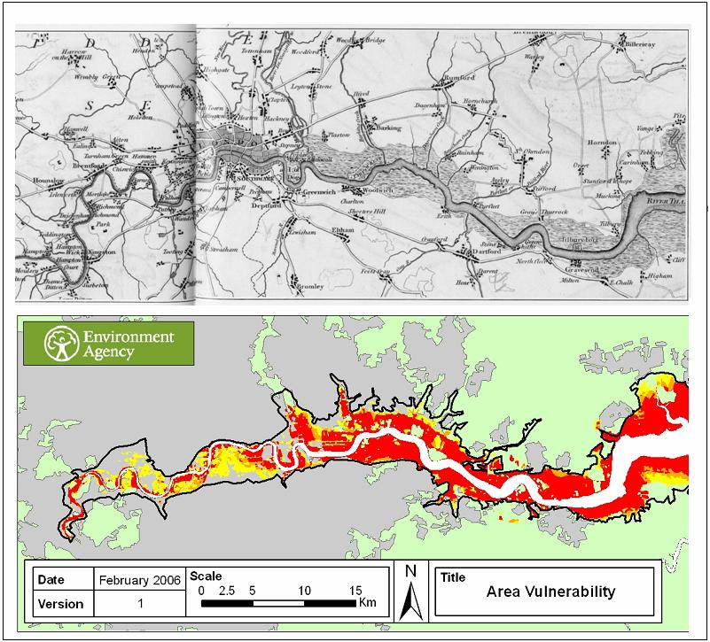
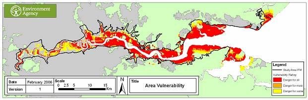
3 The Context: Climate Change in London: Flooding


4 The Thames Barrier built from 1978 to 1984 in operation, likely to be ineffective now by 2030 due to new predictions of sea level rise
5
6 Explanation and Prediction The Scientific Process: Theory, Model, Calibration, Validation, Verification, and then.. Prediction: Validation is a kind of prediction of the past or the present Some, indeed many models are developed only to explain and to enhance our understanding. This is blurred in applied and professional fields like planning Thus the kind of Prediction is all important, in terms of the focus on explanation and validation. Recently some models virtually ignore Validation and move directly to Prediction
7 Types of Prediction and Types of Models The time horizon short term to long term; obvious uncertainties In general the longer the time horizon for prediction, the greater the uncertainty that detail in the model is required. Longer time horizons, simpler models More robust models an overused word hardly every defined but little point in developing very detailed and intricate models which require huge data resources for very long term forecasting when detailed data inputs are needed to forecast independently
8 Requirements: The model we will demonstrate here is for very long time horizons for 50 or 100 years when there are quite well established predictions of physical change climate change, in our case rising sea levels. Thus the model is comparative static to forecast small area population change that we assume adjusts over 50 or 100 years. Contestable of course. The model also needs to be intelligible to a wide variety of professionals and experts as well as informed stakeholders. These stakeholders are uncertain, who are they and how do they interact with the models?
9 The Land Use Transport Model: We are building and land use transport model to forecast small area population change in Greater London as part of a series or sequence of models designed to explore how more global economic change translates into detailed change in population and how this is affected by rising sea levels. The land use transport model sits between the aggregate economic modelling and more detailed flood modelling at the local scale. Here is the sequence of models and we will return to this sequence once I have outlined the LUTM & demoed it

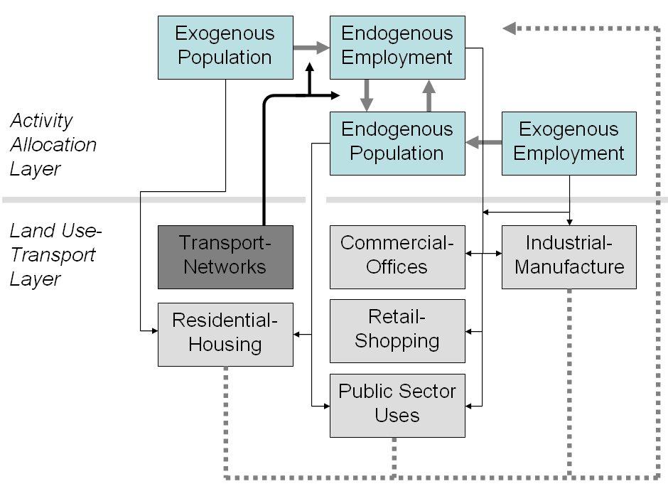
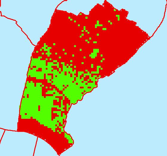
10 The model sits lies at the core of a process of chaining models together built by different groups and coming from different traditions LUTM The LUTM is in two layers activity allocation and physical location
11
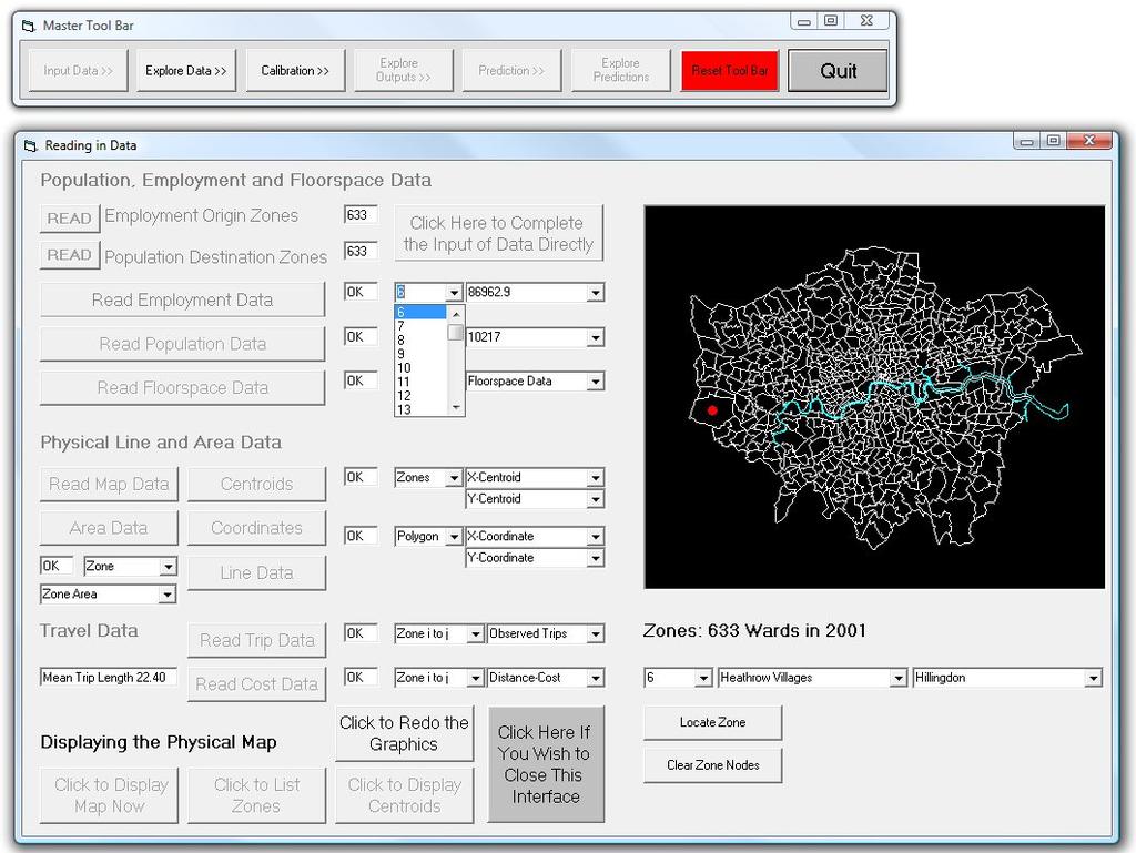
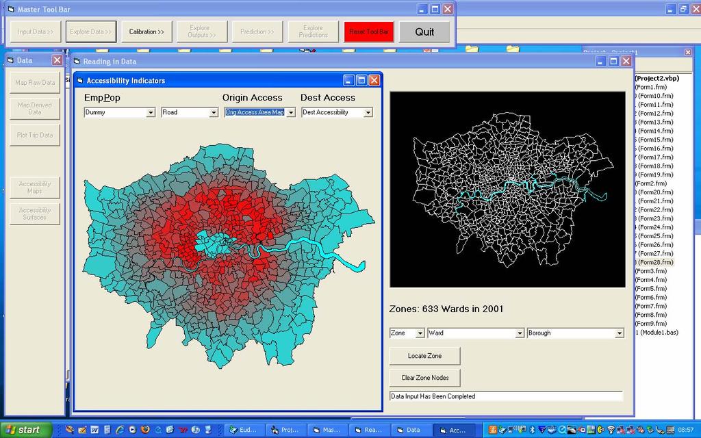
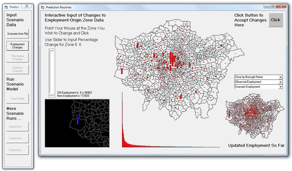
12 The model is simple, highly visual so that any informed expert can use it or at least it can be demoed easily. It is strongly coupled into GIS as mapping is central to the visualisation in fact all the GIS is purpose built It is accessible, immediate and capable of being demoed quickly It is quite different from many of the current large scale LUTM models like UrbanSim, more aggregate This doesn t mean it is better, far from it. It is different and designed for a very different purpose. It is designed to give structure to the process of very long term forecasting and scenario setting The easiest way is to demo it.

13 To give a flavour of the model, I will show some screen shots first
14
:")
15 Modes Road Bus Heavy Rail Light Rail All Trips Road: 38%; Bus: 12%: Heavy Rail: 12%: Light Rail 19%; Other (Walk, Bike, Fly): 19%
16
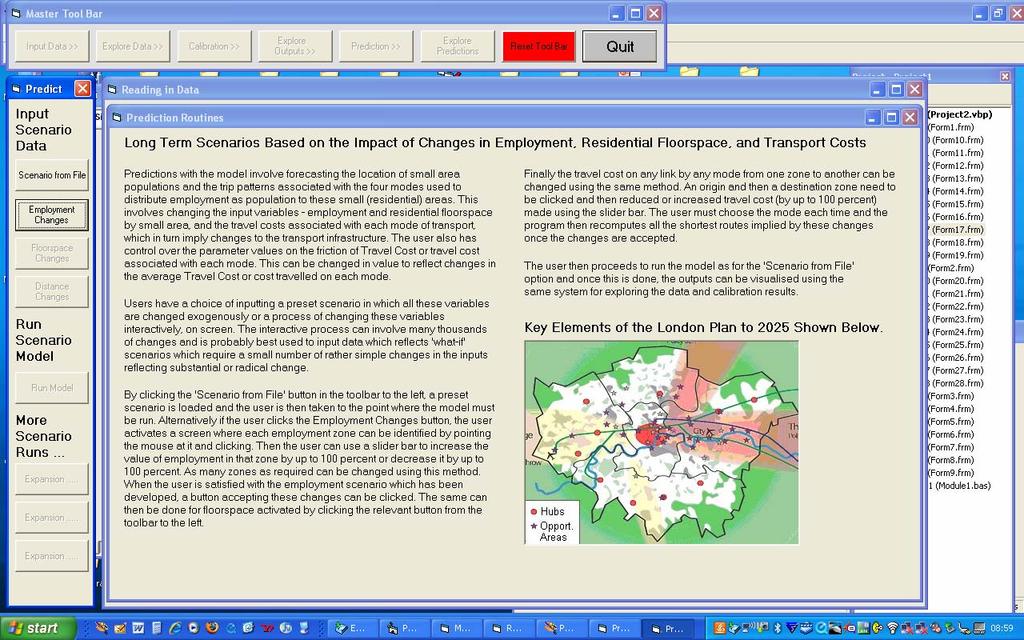
17
18

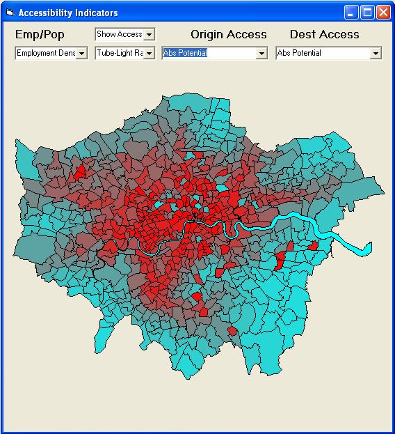
19 Let us run the model I need to go to the desktop

20 For a movie of all this go to our web site

21 You can find more about the Tyndall Cities Project on the Tyndall Web site But there is a launch event here in London October 16 th at GLA? I will circulate details to the all@casa list
22 Ok let me step back and tell you more about the integrated assessment: The Aggregate Economic Forecasting The Scenario Generator The Transport Network Analysis Module The LUTM The Local Development Model The Flooding Models The Aggregate Emissions Models I am going to sketch just two of these models to give a sense of how they are integrated
23 Let us unpack the LUTM process as there are really four types of models/analytical tools here Scenario Generator Generalised Travel Costs LUTM Local Development


24 Light Rail Generalised Costs from Heathrow Ward (minutes)

25 2001 Road Generalised Cost from Heathrow Ward (minutes)

26 The ArcGIS Interface Reflect the cost of travel including: Monetary costs Time Differing calculations for public and private transport Includes policy drivers: Cost of fuel Road user/congestion charging Ticket costs Service frequencies Allows modelling of both geographical and economic costs Generalised travel cost


27 Accessibility from the LUTM model Many different accessibility measures, 8 in all
28


29 Further work on networks From our London database project which Andrew Crooks and Duncan Smith talked about this morning Bring the data in-house Currently we have the Road system in good Detail with speeds etc From TfL
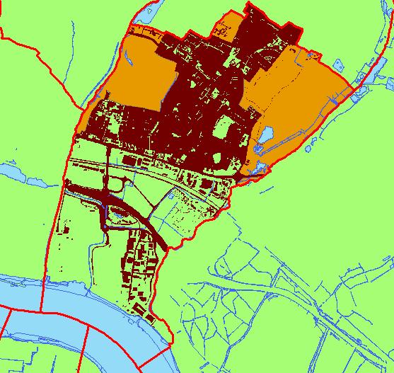
30 The local development model GIS layers at 50 metre resolution
31 Extending the formal project The roll out of all these models will be accomplished in a second phase of Tyndall which in fact is financed not by NERC but by EPSRC under the ARCADIA project
32 Next Steps Extensions to the Gateway Extending the model to generate employment Disaggregating the Model to five population and five employment groups Developing the Land Use Constraints Developing feedbacks from transport to land use Extending the transport costs and travel time to incorporate explicit energy use Extending the location models to incorporate energy use in work and home.
33 Thanks, Any Questions? Look at
Integrated Modelling of the Spatial Impacts of Climate Change In Greater London
 Megacities, Vulnerability and Global Climate Change: FAPESP: City of São Paulo, July 20 th 22 nd 2009 Integrated Modelling of the Spatial Impacts of Climate Change In Greater London Michael Batty University
The Tyndall Cities Integrated Assessment Framework
 The Tyndall Cities Integrated Assessment Framework Alistair Ford 1, Stuart Barr 1, Richard Dawson 1, Jim Hall 2, Michael Batty 3 1 School of Civil Engineering & Geosciences and Centre for Earth Systems
Land Use Transportation Interaction Models
 Opening Lecture 2 September 4 th 2014 Land Use Transportation Interaction Models Michael Batty m.batty@ucl.ac.uk @michaelbatty http://www.complexcity.info/ http://www.spatialcomplexity.info/ Outline Preliminary
Land Use Transportation Interaction Models
 July 27- August 2, 2014 Land Use Transportation Interaction Models Michael Batty m.batty@ucl.ac.uk @michaelbatty http://www.complexcity.info/ http://www.spatialcomplexity.info/ Outline Preliminary Ideas:
Extending the Focus of Urban Modelling Tools
 A Meeting sponsored by ASU, UCL, Newcastle Universities and the British Consulate, 21-23 May 2010 Extending the Focus of Urban Modelling Tools Michael Batty University College London m.batty@ucl.ac.uk
Infrastructure to Explore Geographic Systems through Models and Maps
 Exemplar 1: GeoVUE Then GENeSIS (GENerative e SocIalScience) Infrastructure to Explore Geographic Systems through Models and Maps Michael Batty University College London m.batty@ucl.ac.uk http://www.casa.ucl.ac.uk/
Deep Thunder. Local Area Precision Forecasting for Weather-Sensitive Business Operations (e.g. Electric Utility)
") 1 Deep Thunder Local Area Precision Forecasting for Weather-Sensitive Business Operations (e.g. Electric Utility) Dipl. Ing. Helmut Ludwar Chief Technologist Wien, im Oktober 2010 Forecasts for Weather-Sensitive
1 Deep Thunder Local Area Precision Forecasting for Weather-Sensitive Business Operations (e.g. Electric Utility) Dipl. Ing. Helmut Ludwar Chief Technologist Wien, im Oktober 2010 Forecasts for Weather-Sensitive
BROOKINGS May
 Appendix 1. Technical Methodology This study combines detailed data on transit systems, demographics, and employment to determine the accessibility of jobs via transit within and across the country s 100
Measuring connectivity in London
 Measuring connectivity in London OECD, Paris 30 th October 2017 Simon Cooper TfL City Planning 1 Overview TfL Connectivity measures in TfL PTALs Travel time mapping Catchment analysis WebCAT Current and
Uses of Travel Demand Models Beyond the MTP. Janie Temple Transportation Planning and Programming Division
 Uses of Travel Demand Models Beyond the MTP Janie Temple Transportation Planning and Programming Division October 12, 2011 Presentation Outline What is a Travel Demand Model? Cautionary notes on using
City Models to Explore the Impact of New Urban Infrastructures
 June 29 th 2016 City Models to Explore the Impact of New Urban Infrastructures Michael Batty m.batty@ucl.ac.uk @jmichaelbatty http://www.complexcity.info/ http://www.spatialcomplexity.info/ My Main Themes
Transport Planning in Large Scale Housing Developments. David Knight
 Transport Planning in Large Scale Housing Developments David Knight Large Scale Housing Developments No longer creating great urban spaces in the UK (Hall 2014) Transport Planning Transport planning processes
Simple Spatial Growth Models The Origins of Scaling in Size Distributions
 Lectures on Spatial Complexity 17 th 28 th October 2011 Lecture 3: 21 st October 2011 Simple Spatial Growth Models The Origins of Scaling in Size Distributions Michael Batty m.batty@ucl.ac.uk @jmichaelbatty
Changes in the Spatial Distribution of Mobile Source Emissions due to the Interactions between Land-use and Regional Transportation Systems
 Changes in the Spatial Distribution of Mobile Source Emissions due to the Interactions between Land-use and Regional Transportation Systems A Framework for Analysis Urban Transportation Center University
A BASE SYSTEM FOR MICRO TRAFFIC SIMULATION USING THE GEOGRAPHICAL INFORMATION DATABASE
 A BASE SYSTEM FOR MICRO TRAFFIC SIMULATION USING THE GEOGRAPHICAL INFORMATION DATABASE Yan LI Ritsumeikan Asia Pacific University E-mail: yanli@apu.ac.jp 1 INTRODUCTION In the recent years, with the rapid
Cities, AI, Design, & the Future Can Artificial Intelligence Improve Design Intelligence?
 March 27 th 28 Cities, AI, Design, & the Future Can Artificial Intelligence Improve Design Intelligence? Michael Batty m.batty@ucl.ac.uk @jmichaelbatty http://www.spatialcomplexcity.info/ http://www.casa.ucl.ac.uk/
Taming the Modeling Monster
 Taming the Modeling Monster Starring: Ellen Greenberg Scott McCarey Jim Charlier Audience Poll, part 1 Elected Officials Board Members Public Staff Consultants Journalists Other Audience Poll, part 2 Modeling
APPENDIX I: Traffic Forecasting Model and Assumptions
 APPENDIX I: Traffic Forecasting Model and Assumptions Appendix I reports on the assumptions and traffic model specifications that were developed to support the Reaffirmation of the 2040 Long Range Plan.
THE FUTURE OF FORECASTING AT METROPOLITAN COUNCIL. CTS Research Conference May 23, 2012
 THE FUTURE OF FORECASTING AT METROPOLITAN COUNCIL CTS Research Conference May 23, 2012 Metropolitan Council forecasts Regional planning agency and MPO for Twin Cities metropolitan area Operates regional
Smart Solutions for Spatial Planning
 Smart Solutions for Spatial Planning Aedas R&D [Computational Design Research] Centre for Evolutionary Computing in Architecture [CECA @ UEL] Knowledge Transfer [breaking silos] * constructing consensus
TOWARDS THE DEVELOPMENT OF A MONITORING SYSTEM FOR PLANNING POLICY Residential Land Uses Case study of Brisbane, Melbourne, Chicago and London
 TOWARDS THE DEVELOPMENT OF A MONITORING SYSTEM FOR PLANNING POLICY Residential Land Uses Case study of Brisbane, Melbourne, Chicago and London Presented to CUPUM 12 July 2017 by Claire Daniel Urban Planning/Data
Leaving the Ivory Tower of a System Theory: From Geosimulation of Parking Search to Urban Parking Policy-Making
 Leaving the Ivory Tower of a System Theory: From Geosimulation of Parking Search to Urban Parking Policy-Making Itzhak Benenson 1, Nadav Levy 1, Karel Martens 2 1 Department of Geography and Human Environment,
ENV208/ENV508 Applied GIS. Week 1: What is GIS?
 ENV208/ENV508 Applied GIS Week 1: What is GIS? 1 WHAT IS GIS? A GIS integrates hardware, software, and data for capturing, managing, analyzing, and displaying all forms of geographically referenced information.
UCL Institute for Environmental Design and Engineering
 Heat Risk in London Group Meeting Monday 5 th February 2018, TfL, The International Quarter, London ONGOING AND FUTURE WORK Mapping heat vulnerability in London Dr Anna Mavrogianni Senior Lecturer in Sustainable
Introduction to ecosystem modelling Stages of the modelling process
 NGEN02 Ecosystem Modelling 2018 Introduction to ecosystem modelling Stages of the modelling process Recommended reading: Smith & Smith Environmental Modelling, Chapter 2 Models in science and research
CIV3703 Transport Engineering. Module 2 Transport Modelling
 CIV3703 Transport Engineering Module Transport Modelling Objectives Upon successful completion of this module you should be able to: carry out trip generation calculations using linear regression and category
UPTAKE AND PATHWAYS OF COASTAL ADAPTATION PROCESSES IN AUSTRALIA
 2015 Effect of Climate Change on the World's Oceans - Santos, Brazil UPTAKE AND PATHWAYS OF COASTAL ADAPTATION PROCESSES IN AUSTRALIA COASTAL COLLABORATION CLUSTER: MEETING COASTAL CHALLENGES Débora M.
Transit Time Shed Analyzing Accessibility to Employment and Services
 Transit Time Shed Analyzing Accessibility to Employment and Services presented by Ammar Naji, Liz Thompson and Abdulnaser Arafat Shimberg Center for Housing Studies at the University of Florida www.shimberg.ufl.edu
GLA small area population projection methodology
 Update 2017-04 GLA small area population projection methodology 2015-based projections February 2017 Introduction The GLA produces a range of annually updated demographic projections for London. Among
INTRODUCTION. In March 1998, the tender for project CT.98.EP.04 was awarded to the Department of Medicines Management, Keele University, UK.
 INTRODUCTION In many areas of Europe patterns of drug use are changing. The mechanisms of diffusion are diverse: introduction of new practices by new users, tourism and migration, cross-border contact,
Data Collection. Lecture Notes in Transportation Systems Engineering. Prof. Tom V. Mathew. 1 Overview 1
 Data Collection Lecture Notes in Transportation Systems Engineering Prof. Tom V. Mathew Contents 1 Overview 1 2 Survey design 2 2.1 Information needed................................. 2 2.2 Study area.....................................
ECNU Writing Workshop, October 28 th, Urban Models: The Decline of Theory, The Rise of Big Data and the Fragmentation of Applications
 ECNU Writing Workshop, October 28 th, 2012 CAMUSS Urban Models: The Decline of Theory, The Rise of Big Data and the Fragmentation of Applications Michael Batty University College London m.batty@ucl.ac.uk
Typical information required from the data collection can be grouped into four categories, enumerated as below.
 Chapter 6 Data Collection 6.1 Overview The four-stage modeling, an important tool for forecasting future demand and performance of a transportation system, was developed for evaluating large-scale infrastructure
Geostatistics and Spatial Scales
 Geostatistics and Spatial Scales Semivariance & semi-variograms Scale dependence & independence Ranges of spatial scales Variable dependent Fractal dimension GIS implications Spatial Modeling Spatial Analysis
Mapping the Future: Energizing Datadriven
 Mapping the Future: Energizing Datadriven Policy Making and Investment in Renewable Energy Anthony Lopez Manager Geospatial Data Science National Renewable Energy Laboratory June 6, 2016 Outline Context
StanCOG Transportation Model Program. General Summary
 StanCOG Transportation Model Program Adopted By the StanCOG Policy Board March 17, 2010 What are Transportation Models? General Summary Transportation Models are technical planning and decision support
Task A4, Appendix A: Maryland Land Use and Impact Assessment Model
 Task A4, Appendix A: Maryland Land Use and Impact Assessment Model The LEAM Model During the last two decades, spatial analysis tools, geographic information systems (GIS), and remote-sensing (RS) technologies
HORIZON 2030: Land Use & Transportation November 2005
 PROJECTS Land Use An important component of the Horizon transportation planning process involved reviewing the area s comprehensive land use plans to ensure consistency between them and the longrange transportation
2040 MTP and CTP Socioeconomic Data
 SE Data 6-1 24 MTP and CTP Socioeconomic Data Purpose of Socioeconomic Data The socioeconomic data (SE Data) shows the location of the population and employment, median household income and other demographic
A PROTOTYPE FOR THE APPLICATION OF CLIMATE INFORMATION TO IMPROVE HIGHWAY AND INFRASTRUCTURE PLANNING IN THE COASTAL REGIONS OF LAKE VICTORIA
 A PROTOTYPE FOR THE APPLICATION OF CLIMATE INFORMATION TO IMPROVE HIGHWAY AND INFRASTRUCTURE PLANNING IN THE COASTAL REGIONS OF LAKE VICTORIA Kara Smith October 26, 2016 Lake Victoria Levels Sudden increase
Introduction to Coastal GIS
 Introduction to Coastal GIS Event was held on Tues, 1/8/13 - Thurs, 1/10/13 Time: 9:00 am to 5:00 pm Location: Roger Williams University, Bristol, RI Audience: The intended audiences for this course are
TRANSPORTATION MODELING
 TRANSPORTATION MODELING Modeling Concept Model Tools and media to reflect and simple a measured reality. Types of Model Physical Model Map and Chart Model Statistics and mathematical Models MODEL? Physical
Breaking away from trend-based analysis for regional modelling and planning
 22nd International Congress on Modelling and Simulation, Hobart, Tasmania, Australia, 3 to 8 December 2017 mssanz.org.au/modsim2017 Breaking away from trend-based analysis for regional modelling and planning
Integrating Origin and Destination (OD) Study into GIS in Support of LIRR Services and Network Improvements
 Study into GIS in Support of LIRR Services and Network Improvements") Integrating Origin and Destination (OD) Study into GIS in Support of LIRR Services and Network Improvements GIS In Transit Conference, Washington, DC Long Island Rail Road Pyung ho Kim Date: September
Integrating Origin and Destination (OD) Study into GIS in Support of LIRR Services and Network Improvements GIS In Transit Conference, Washington, DC Long Island Rail Road Pyung ho Kim Date: September
Jim Fox. copyright UNC Asheville's NEMAC
 Decisions and System Thinking Jim Fox November, 2012 1 UNC Asheville s s NEMAC National Environmental Modeling and Analysis Center Applied Research and technology development on integration of environmental
Google Maps and Beyond
 Google Maps and Beyond Aaron Paul First American Title apaul@firstam.com 2015 APRA Symposium Association of Professional Reserve Analysts May 2 nd, 2015 Google Maps and Beyond - Overview Business case
Introduction to ecosystem modelling (continued)
") NGEN02 Ecosystem Modelling 2015 Introduction to ecosystem modelling (continued) Uses of models in science and research System dynamics modelling The modelling process Recommended reading: Smith & Smith
NGEN02 Ecosystem Modelling 2015 Introduction to ecosystem modelling (continued) Uses of models in science and research System dynamics modelling The modelling process Recommended reading: Smith & Smith
Joint-accessibility Design (JAD) Thomas Straatemeier
 Thomas Straatemeier") Joint-accessibility Design (JAD) Thomas Straatemeier To cite this report: Thomas Straatemeier (2012) Joint-accessibility Design (JAD), in Angela Hull, Cecília Silva and Luca Bertolini (Eds.) Accessibility
Joint-accessibility Design (JAD) Thomas Straatemeier To cite this report: Thomas Straatemeier (2012) Joint-accessibility Design (JAD), in Angela Hull, Cecília Silva and Luca Bertolini (Eds.) Accessibility
Comparison of spatial methods for measuring road accident hotspots : a case study of London
 Journal of Maps ISSN: (Print) 1744-5647 (Online) Journal homepage: http://www.tandfonline.com/loi/tjom20 Comparison of spatial methods for measuring road accident hotspots : a case study of London Tessa
How GIS based Visualizations Support Land Use and Transportation Modeling
 How GIS based Visualizations Support Land Use and Transportation Modeling ESRI International Users Conference San Diego, CA - July 23, 2015 Prepared by: Troy Hightower Introduction This presentation will
GENERALIZATION IN THE NEW GENERATION OF GIS. Dan Lee ESRI, Inc. 380 New York Street Redlands, CA USA Fax:
 GENERALIZATION IN THE NEW GENERATION OF GIS Dan Lee ESRI, Inc. 380 New York Street Redlands, CA 92373 USA dlee@esri.com Fax: 909-793-5953 Abstract In the research and development of automated map generalization,
Issues around verification, validation, calibration, and confirmation of agent-based models of complex spatial systems
 Issues around verification, validation, calibration, and confirmation of agent-based models of complex spatial systems David O Sullivan 1 Mark Gahegan 2 1 School of Geography, Geology, and Environmental
MPOs SB 375 LAFCOs SCAG Practices/Experiences And Future Collaborations with LAFCOs
 Connecting LAFCOs and COGs for Mutual Benefits MPOs SB 375 LAFCOs SCAG Practices/Experiences And Future Collaborations with LAFCOs Frank Wen, Manager Research & Analysis Land Use & Environmental Planning
3/29/11. Why bother with tools? Incorporating Decision Support Tools into Climate Adaptation Planning. A Simplified Planning Process
 Incorporating Decision Support Tools into Climate Adaptation Planning Why bother with tools? Tools don t eliminate complexity but they can help deal with it" Tools can:"! Help incorporate science into
Economic and Social Urban Indicators: A Spatial Decision Support System for Chicago Area Transportation Planning
 Economic and Social Urban Indicators: A Spatial Decision Support System for Chicago Area Transportation Planning Piyushimita Thakuriah (Vonu), P.S. Sriraj, Paul Metaxatos, Inshu Minocha & Tanushri Swarup
Geometric Algorithms in GIS
 Geometric Algorithms in GIS GIS Visualization Software Dr. M. Gavrilova GIS Software for Visualization ArcView GEO/SQL Digital Atmosphere AutoDesk Visual_Data GeoMedia GeoExpress CAVE? Visualization in
GIS-Based Analysis of the Commuting Behavior and the Relationship between Commuting and Urban Form
 GIS-Based Analysis of the Commuting Behavior and the Relationship between Commuting and Urban Form 1. Abstract A prevailing view in the commuting is that commuting would reconstruct the urban form. By
MOBILITIES AND LONG TERM LOCATION CHOICES IN BELGIUM MOBLOC
 MOBILITIES AND LONG TERM LOCATION CHOICES IN BELGIUM MOBLOC A. BAHRI, T. EGGERICKX, S. CARPENTIER, S. KLEIN, PH. GERBER X. PAULY, F. WALLE, PH. TOINT, E. CORNELIS SCIENCE FOR A SUSTAINABLE DEVELOPMENT
Spatial units (Levels 0 and 1)
") Spatial units (Levels 0 and 1) Project: Advancing the SEEA Experimental Ecosystem Accounting Overview: Spatial units 1. Learning objectives 2. Level 1: Presentation & group exercise Spatial units (10m
Spatial units (Levels 0 and 1) Project: Advancing the SEEA Experimental Ecosystem Accounting Overview: Spatial units 1. Learning objectives 2. Level 1: Presentation & group exercise Spatial units (10m
06/04/2015. Overview: Spatial units. Advancing the SEEA Experimental Ecosystem Accounting Spatial units (Level 1)
") Advancing the SEEA Experimental Ecosystem Accounting Spatial units (Level 1) Advancing the SEEA-EEA Project Overview: Spatial units 1. Learning objectives 2. Level 1: Presentation & group exercise Spatial
Advancing the SEEA Experimental Ecosystem Accounting Spatial units (Level 1) Advancing the SEEA-EEA Project Overview: Spatial units 1. Learning objectives 2. Level 1: Presentation & group exercise Spatial
A Simplified Travel Demand Modeling Framework: in the Context of a Developing Country City
 A Simplified Travel Demand Modeling Framework: in the Context of a Developing Country City Samiul Hasan Ph.D. student, Department of Civil and Environmental Engineering, Massachusetts Institute of Technology,
A Web-GIS Based Integrated Climate Adaptation Model (ICAM): Exemplification from the City of Melbourne, Australia
: Exemplification from the City of Melbourne, Australia") A Web-GIS Based Integrated Climate Adaptation Model (ICAM): Exemplification from the City of Melbourne, Australia JOSHPHAR KUNAPO 1,2, MATTHEW J. BURNS 1, TIM D. FLETCHER 1, ANTHONY R. LADSON 3, LUKE CUNNINGHAM
A Web-GIS Based Integrated Climate Adaptation Model (ICAM): Exemplification from the City of Melbourne, Australia JOSHPHAR KUNAPO 1,2, MATTHEW J. BURNS 1, TIM D. FLETCHER 1, ANTHONY R. LADSON 3, LUKE CUNNINGHAM
Accessibility analysis of multimodal transport systems using advanced GIS techniques
 Urban Transport XIII: Urban Transport and the Environment in the 21st Century 655 Accessibility analysis of multimodal transport systems using advanced GIS techniques T. Vorraa Citilabs Regional Director,
The Building Blocks of the City: Points, Lines and Polygons
 The Building Blocks of the City: Points, Lines and Polygons Andrew Crooks Centre For Advanced Spatial Analysis andrew.crooks@ucl.ac.uk www.gisagents.blogspot.com Introduction Why use ABM for Residential
Implementing Visual Analytics Methods for Massive Collections of Movement Data
 Implementing Visual Analytics Methods for Massive Collections of Movement Data G. Andrienko, N. Andrienko Fraunhofer Institute Intelligent Analysis and Information Systems Schloss Birlinghoven, D-53754
1. Omit Human and Physical Geography electives (6 credits) 2. Add GEOG 677:Internet GIS (3 credits) 3. Add 3 credits to GEOG 797: Final Project
 2. Add GEOG 677:Internet GIS (3 credits) 3. Add 3 credits to GEOG 797: Final Project") The Department of Geography and the Office of Professional Studies propose to modify the Master of Professional Studies in Geospatial Information Sciences (GIS) as follows: 1. Omit Human and Physical Geography
The Department of Geography and the Office of Professional Studies propose to modify the Master of Professional Studies in Geospatial Information Sciences (GIS) as follows: 1. Omit Human and Physical Geography
GEOGRAPHIC INFORMATION SYSTEMS Session 8
 GEOGRAPHIC INFORMATION SYSTEMS Session 8 Introduction Geography underpins all activities associated with a census Census geography is essential to plan and manage fieldwork as well as to report results
How GIS can support the Production
 How GIS can support the Production of Local Development Plans ESRI User Conference 2017 Mandy Maas ARUP Who we are Shaping a better world We are an independent firm of designers, planners, engineers, consultants
Decentralisation and its efficiency implications in suburban public transport
 Decentralisation and its efficiency implications in suburban public transport Daniel Hörcher 1, Woubit Seifu 2, Bruno De Borger 2, and Daniel J. Graham 1 1 Imperial College London. South Kensington Campus,
From transport to accessibility: the new lease of life of an old concept
 Paris 07 /01/ 2015 From transport to accessibility: the new lease of life of an old concept Pr. Yves Crozet Laboratory of Transport Economics (LET) University of Lyon (IEP) - France yves.crozet@let.ish-lyon.cnrs.fr
Brian J. Morton Center for Urban and Regional Studies University of North Carolina - Chapel Hill June 8, 2010
 Brian J. Morton Center for Urban and Regional Studies University of North Carolina - Chapel Hill June 8, 2010 1. TRANUS Highway vehicle technology Trips Mode choice Link-level traffic volumes and average
Use and demand of regions and cities
 Use and demand of regions and cities > Roger Read > Deputy Director of Physical Planning Strathclyde Regional Council 1976-1996 > Secretary General METREX 1996-present > METREX - founded in 1996 > 50+
Population and Employment Forecast
 Population and Employment Forecast How Do We Get the Numbers? Thurston Regional Planning Council Technical Brief Updated July 2012 We plan for forecast growth in Population and Employment, but where do
Creating a Staff Development Plan with Esri
 Creating a Staff Development Plan with Esri Michael Green David Schneider Guest Presenter: Shane Feirer, University of California Esri UC 2014 Technical Workshop Agenda What is a Staff Development Plan?
Adapting an Existing Activity Based Modeling Structure for the New York Region
 Adapting an Existing Activity Based Modeling Structure for the New York Region presented to 2018 TRB Innovations in Travel Modeling Conference Attendees presented by Rachel Copperman Jason Lemp with Thomas
structure Networking for the future addressing climate change effects on slope instability Tom Dijkstra and Neil Dixon Loughborough University, UK
 Networking for the future addressing climate change effects on slope instability Tom Dijkstra and Neil Dixon Loughborough University, UK structure 1. CLIFFS an introduction 2. UK climate change forecasts
Regional GIS Presentation for Small and Large Jurisdictions. Michelle E. Fults GIS Manager January 8, 2009
 Regional GIS Presentation for Small and Large Jurisdictions Michelle E. Fults GIS Manager January 8, 2009 Presentation Contributions from Juston Manville Henrico County Kevin Nelson Hanover County Mark
Experiences and Directions in National Portals"
 FIG Seminar on e-land Administration Innsbruck/Austria 2-4 June 2004 "ESRI's Experiences and Directions in National Portals" Kevin Daugherty Cadastral/Land Records Manager ESRI Topic Points Technology
COSMIC: COmplexity in Spatial dynamic
 COSMIC: COmplexity in Spatial dynamic MICs 9 10 November, Brussels Michael Batty University College London m.batty@ucl.ac.uk http://www.casa.ucl.ac.uk/ Outline The Focus of the Pilot The Partners: VU,
Urban Spatial Scenario Design Modelling (USSDM) in Dar es Salaam: Background Information
 in Dar es Salaam: Background Information") Urban Spatial Scenario Design Modelling (USSDM) in Dar es Salaam: Background Information Modelling urban settlement dynamics in Dar es Salaam Revision: 2 (July 2013) Prepared by: Katja Buchta TUM team
Urban Spatial Scenario Design Modelling (USSDM) in Dar es Salaam: Background Information Modelling urban settlement dynamics in Dar es Salaam Revision: 2 (July 2013) Prepared by: Katja Buchta TUM team
Lecture 7: Cellular Automata Modelling: Principles of Cell Space Simulation
 MRes in Advanced Spatial Analysis and Visualisation Lecture 7: Cellular Automata Modelling: Principles of Cell Space Simulation Outline Types of Urban Models Again The Cellular Automata Approach: Urban
New Methods for GeoDesign with ArcGIS and CityEngine. Dr. Özgür Ertac, Prof. Dr. Jörg Schaller, Cristina Mattos Tech. Uni. Munich, Esri Germany
 New Methods for GeoDesign with ArcGIS and CityEngine Dr. Özgür Ertac, Prof. Dr. Jörg Schaller, Cristina Mattos Tech. Uni. Munich, Esri Germany Agenda Evolution in 3D Introduction 3D Across the ArcGIS Platform
Construction in my Neighborhood - Communication with Stakeholder and Public -
 Construction in my Neighborhood - Communication with Stakeholder and Public - Presented by: Navneet Virk East Bay Municipal Utility District, Oakland, CA 0 Mission at EBMUD To manage the natural resources
Mapping Accessibility Over Time
 Journal of Maps, 2006, 76-87 Mapping Accessibility Over Time AHMED EL-GENEIDY and DAVID LEVINSON University of Minnesota, 500 Pillsbury Drive S.E., Minneapolis, MN 55455, USA; geneidy@umn.edu (Received
MALDIVES. Regional Expert Workshop On Land Accounting For SDG Monitoring & Reporting (25-27 th Sept 2017) - Fathimath Shanna, Aishath Aniya -
 - Fathimath Shanna, Aishath Aniya -") MALDIVES Regional Expert Workshop On Land Accounting For SDG Monitoring & Reporting (25-27 th Sept 2017) - Fathimath Shanna, Aishath Aniya - ABOUT MALDIVES Approximately 860 km long and 120 km wide Consists
MALDIVES Regional Expert Workshop On Land Accounting For SDG Monitoring & Reporting (25-27 th Sept 2017) - Fathimath Shanna, Aishath Aniya - ABOUT MALDIVES Approximately 860 km long and 120 km wide Consists
Town Planning Agency of Le Havre: The Industrial Network Tool, a decision support system that integrates energy, economy, logistics and environnement
 NA-5790/JD/JFlo - April 22nd, 2015 Town Planning Agency of Le Havre: The Industrial Network Tool, a decision support system that integrates energy, economy, logistics and environnement AURH Town planning
Spatial Units (Level 1)
") Spatial Units (Level 1) Project: Advancing the SEEA Experimental Ecosystem Accounting Overview: Spatial Units 1. Learning objectives 2. Review of Level 0 (5m) 3. Level 1 (Compilers): Presentation & group
Spatial Units (Level 1) Project: Advancing the SEEA Experimental Ecosystem Accounting Overview: Spatial Units 1. Learning objectives 2. Review of Level 0 (5m) 3. Level 1 (Compilers): Presentation & group
Model development for WebAtlas system applying in administration management.
 Model development for WebAtlas system applying in administration management. Bui Ngoc Quy, Vo Ngọc Dung, Nguyen Danh Duc, University of mining and geology, Viet Nam Key words: Webatlas, Web Map, Electronic
Design and implementation of a new meteorology geographic information system
 Design and implementation of a new meteorology geographic information system WeiJiang Zheng, Bing. Luo, Zhengguang. Hu, Zhongliang. Lv National Meteorological Center, China Meteorological Administration,
SA Geospatial Analysis Platform (GAP) Methodology*, collaborators & data sources
 Methodology*, collaborators & data sources") SA Geospatial Analysis Platform (GAP) Methodology*, collaborators & data sources Mesoframe CSIR, dti, the Presidency & GTZ Demarcation of South Africa into a grid of 50 Km 2 mesozones, nested within important
SA Geospatial Analysis Platform (GAP) Methodology*, collaborators & data sources Mesoframe CSIR, dti, the Presidency & GTZ Demarcation of South Africa into a grid of 50 Km 2 mesozones, nested within important
Imagination and Scientific Visualizations. Greg Trafton (NRL) Susan Trickett (NRL) Chris Schunn (University of Pittsburgh)
 Susan Trickett (NRL) Chris Schunn (University of Pittsburgh)") Imagination and Scientific Visualizations Greg Trafton (NRL) Susan Trickett (NRL) Chris Schunn (University of Pittsburgh) Creativity in Science Many anecdotes of creativity in scientific discovery seem
Imagination and Scientific Visualizations Greg Trafton (NRL) Susan Trickett (NRL) Chris Schunn (University of Pittsburgh) Creativity in Science Many anecdotes of creativity in scientific discovery seem
Spatial Decision Support Systems for policy support in urban planning contexts
 Spatial Decision Support Systems for policy support in urban planning contexts Roel Vanhout P.O. Box 463 6200 AL Maastricht The Netherlands www.riks.nl About RIKS w Independent research institute w Founded
Understanding Weather and Climate Risk. Matthew Perry Sharing an Uncertain World Conference The Geological Society, 13 July 2017
 Understanding Weather and Climate Risk Matthew Perry Sharing an Uncertain World Conference The Geological Society, 13 July 2017 What is risk in a weather and climate context? Hazard: something with the
INTRODUCTION TO TRANSPORTATION SYSTEMS
 INTRODUCTION TO TRANSPORTATION SYSTEMS Lectures 5/6: Modeling/Equilibrium/Demand 1 OUTLINE 1. Conceptual view of TSA 2. Models: different roles and different types 3. Equilibrium 4. Demand Modeling References:
Visualizing Big Data on Maps: Emerging Tools and Techniques. Ilir Bejleri, Sanjay Ranka
 Visualizing Big Data on Maps: Emerging Tools and Techniques Ilir Bejleri, Sanjay Ranka Topics Web GIS Visualization Big Data GIS Performance Maps in Data Visualization Platforms Next: Web GIS Visualization
MOR CO Analysis of future residential and mobility costs for private households in Munich Region
 MOR CO Analysis of future residential and mobility costs for private households in Munich Region The amount of the household budget spent on mobility is rising dramatically. While residential costs can
USING 3D GIS TO ASSESS ENVIRONMENTAL FLOOD HAZARDS IN MINA
 King Fahd University of Petroleum & Minerals College of Environmental Design Geographical Information system USING 3D GIS TO ASSESS ENVIRONMENTAL FLOOD HAZARDS IN MINA Prepared by : Ali AL-Zahrani OUTLINE
Data for transport planning and management Why integration and management? Issues in transport data integration
 Zhengdong HUANG Wuhan University 1 Data for transport planning and management Why integration and management? Issues in transport data integration Technical aspect Institutional aspect Action examples
University of Sheffield Department of Town & Regional Planning. Urban Design & Place- making Credit Value: 20 Level: 2
 TRP210 Urban Design & Place- making Autumn Module Coordinator: Dr Aidan While A3 group report and presentation & Individual report The nature and concerns of urban design Modernism and the contemporary
Interactive Visualization Tool (InViTo)
") Interactive Visualization Tool (InViTo) Stefano Pensa To cite this report: Stefano Pensa (2012) Interactive Visualization Tool (InViTo), in Angela Hull, Cecília Silva and Luca Bertolini (Eds.) Accessibility
Interactive Visualization Tool (InViTo) Stefano Pensa To cite this report: Stefano Pensa (2012) Interactive Visualization Tool (InViTo), in Angela Hull, Cecília Silva and Luca Bertolini (Eds.) Accessibility