Cities, AI, Design, & the Future Can Artificial Intelligence Improve Design Intelligence?
|
|
|
- Christian Howard
- 5 years ago
- Views:
Transcription

1 March 27 th 28 Cities, AI, Design, & the Future Can Artificial Intelligence Improve Design Intelligence? Michael
2 An Outline of the Talk Artificial Intelligence and Design Intelligence Basic Concepts about Complexity Theory Making Sense of Urban Development: Key Factors Related Concepts: Geodesign, Networks, ABM Design Solutions as Weighted Averaging Actual Development using Neural Networks A Simple Example: Averaging by Overlay Generalisation: Modelling at the Very Local Scale
3 Artificial Intelligence and Design Intelligence Budhu asked me to speak on AI and Cities. I am in way an expert but let me throw out some ideas I will not talk about how we get hold of massive data sets and search for underlying pattern but about design intelligence and how this differs from artificial intelligence The problem we have in cities is what we see is not necessarily what we want. In short if we explain how things emerge and evolve actual development this is usually different from optimal, ideal development So in a way, AI as it is developing to make sense of what we see is not something we see very much of so far we do see a lot of modelling which in a way is a kind of AI
4 Basic Concepts about Complexity Theory This will be my theme then how we generate design intelligence and then how we can think of this as artificial intelligence. First let me describe some basic assumptions Cities develop, grow & change from the bottom up Countless comparatively uncoordinated decisions (rational within their own frame) generate coordination across many scales Adam Smith s Invisible Hand This manifests itself spatially as order and pattern which is said to emerge at higher scales from that which the forces that determine them originate. For many years we have accepted that we might be able to simulate this kind of emergence
5 The simplest examples are fractals the dendritic pattern of streets in cities that determine optimal spatial patterns of how cities are resourced, how the hierarchy of central places is ordered and so on There has been plenty of thinking about cities in these terms. My own work on Fractal Cities which dates from the mid 98s is one stream In this sense, our models embody a degree of intelligence artificial to an extent although the assumption is that such intelligence should mirror how the system actually develops. In short our models should not be about artificial processes but real. This talk is about the tension between real and artificial but also between organic and designed.
6 But there has been very little thinking in terms of how plans are made. We tend to think of these as being somehow imposed on the city as top down, yet plans usually emerge from the bottom up The clearest theories of design reflect this notion that a plan is successively developed from a simple seed by a designer who works away at it recursively. In this sense then design is about a kind of artificial intelligence but more important about intelligence that leads to better systems, solutions In fact, design often conflicts with AI in that AI does not necessarily produce better results in any sense for to replicate what we do, does not mean that what we do is best. So in this talk I will question AI in helping us to design.
7 Making Sense of Urban Development: Key Factors Let me return to urban development. The complexity model of emergence suggests that many factors determine the pattern of urban development that occurs, and we need to know these There is thus some sense that we might be able to produce models that combine a series of independent variables factors that can be used to predict such patterns. Indeed our urban models tend to attempt this such as CA models Recently developments in AI suggest that we might be able to find the patterns that lead to actual development but this is not necessarily the best plan
8 So I am going to begin with showing you how we can generate a plan which is best but what I will do here is generate the plan as a process of group decision-making again from the bottom up in such a way that the plan emerges from different and often conflicting individual plans. In a sense, my model will be based on a kind of intelligence but not one which necessarily leads to one actually happens The model is based on an old idea of pooling opinions but it has surfaced over the last 6 years in many contexts I will develop it here for a very simple example and then point the way to more information about it It has a quite well defined formal representation but here I will develop the idea here visually
9 Related Concepts: Geodesign, Networks, ABM Geodesign: group decision-making: designing for change cannot be a solitary activity. Rather, it inevitably is a team endeavor with many participants (from the design professions and geographic sciences) Carl Steinitz (22) A Framework for Geodesign, ESRI Press, p. ix Agents and Actors: a model of how agents combine their conflicting views of a design solution to a consensus; an agent based model (ABM) Graphs and Networks but non-spatial networks social networks: a social power structure Building Models involves many forms of intelligence
10 Design Solutions as Weighted Averaging Factor Access to Housing Factor 2 Access to Retailing Factor 3 Access to Health Care Factor 4 Access to Education
11 Adding or Synthesising Physical Influences + + Boolean Operations
12 Factor Factor 2 Factor 3 + Solution Factor 4
13
14
15
16 2 4 3
17
18 Actual Development using Neural Networks Factor Factor 2 Factor 3? Observed Outcome Design Solution Factor 4
19
20 A Simple Example: Averaging by Overlay The list of factors: accessibility to existing urban services, costs of spatial congestion, accessibility to recreational amenities, areas of acceptable micro-climate, areas of water catchment and poor drainage, institutional constraints imposed by government, accessibility to external urban markets, subsidence and extensive industrial pollution, areas of suitable topography, rural amenity areas, historic urban areas, and conservation of high quality agricultural quality.
21
22
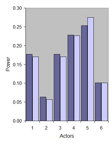
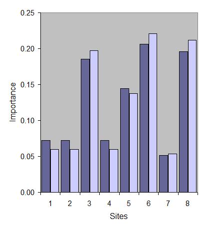
23 Generalisation: Modelling at the Very Local Scale The network of relations between factors: actors &agents The problem the resolution of conflict over a change in use of land in a dense urban area design maybe, decision The agents in the models actors, stakeholders versus sites/buildings The way the agents interact across the maps of what they consider significant to change of use The way the agents effect compromise two problems which are duals of one another rather technical but a sketch of how we might proceed
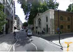
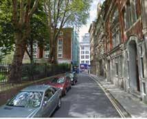
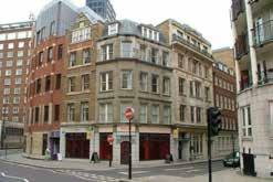
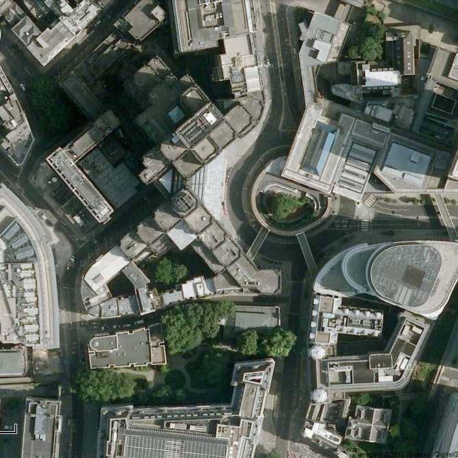
24 A long preamble I know but let me begin with the problem first and then I will sketch the model The problem is one of reconciling different interests in land development in the heart of a world city: London It is as close to the heart of the city as possible for it centres on the postcode ECA AA which is the old General Post Office and is now adjacent to the new London Stock Exchange (which is almost virtual now) A very historic area with enormous development pressures It s a TOY MODEL with 6 agents or actors and 8 sites let us see how it works Of course to make it real we can scale it in many ways many actors many more buildings etc. and a lot of data on processes

25
26
27

28
29
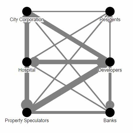
30 Actors/ Stakeholders City Corporation 2 Residents 3 Hospital NHS 4 Developers 5 Property Spec 6 Banks Sites/Buildings/ Locations Aldersgate Complex 2 St Botolph s 3 Nomura House 4 Milton House 5 Postmans Park 6 Bank of America 7 Barts New Building 8 Barts Old Building
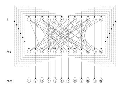
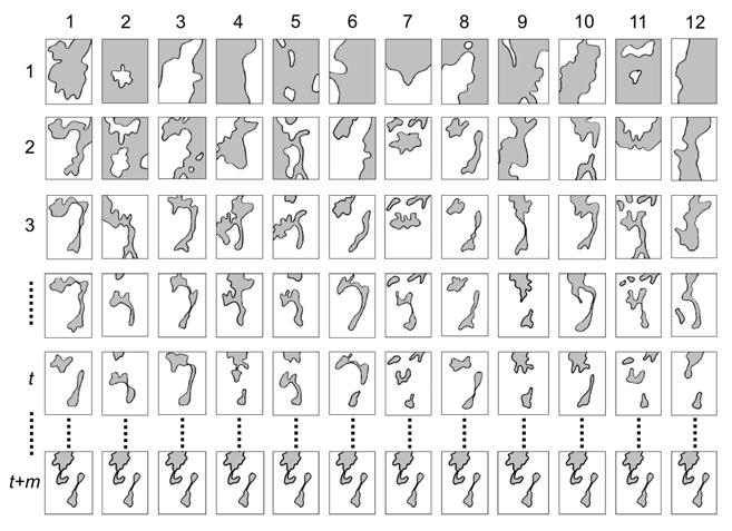
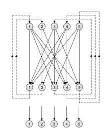
31 Sites/Buildings Agents City Corporation 2 Residents 3 Hospital NHS 4 Developers 5 Property Speculators 6 Banks
32 Agents Sites/Buildings Aldersgate Complex 2 St Botolph s 3 Nomura House 4 Milton House 5 Postmans Park 6 Bank of America 7 Barts New Building 8 Barts Old Building City Corporation 2 Residents 3 Hospital NHS 4 Developers 5 Property Spec 6 Banks = M(ap)
33 Centre for Advanced Spatial Analysis, University College London Centre for Advanced Spatial Analysis = A = M M T The Primal: Interactions between actors wrt sites
34 Centre for Advanced Spatial Analysis, University College London Centre for Advanced Spatial Analysis = S = M T M The Dual: Interactions between sites wrt actors
35

36
37
38 The Network Averaging X Set of Maps 3/4 /4 3/4 3/4 3/4 /4 /5 /5 /5 /5 /5 3/4 3/8 /4 /8 3/4 3/8 3/4 5/8 3/4 4/8 /4 2/8 yields 3/2 /2 3/ 4/2 7/2 2/2 /8 /8 2/8 2/8 2/8 A New Averaged Set of Maps
39 And then we average them again using the same network And this yields a new map, And so on until all the differences between the actors with respect to their maps are ironed out and we get the following map We can do this on the dual problem, on the sites and iron out the differences between sites with respect to their actors
40
41 Agents 7% 9% City Corporation 7% 2 Residents 6% 3 Hospital NHS 7% 5% 7% 4% 7% 4 Developers 23% 5 Property Spec 25% 6 Banks % 2% 8% Buildings
42 Next Steps Real problems very large networks, types of connection Intensity or desirability maps; spatial averaging as developed quite widely in overlay analysis in GIS Rational averaging, simple averaging, weighting averaging, dominance, and other strategies of compromise or not; networks that don t lead to solutions The model is longstanding not new, what is new is the dual primal and the embedding of maps into it
 An Approach to Rational Design: Part : The Structure of Design Problems, Part 2: Design Problems as Markov Chains, Architectural Design, 4, 436-439, 498-5 Batty, M.")
43 References over Many Years French, J. R. P. (956) A Formal Theory of Social Power, Psychological Review, 63, Batty, M. (97) An Approach to Rational Design: Part : The Structure of Design Problems, Part 2: Design Problems as Markov Chains, Architectural Design, 4, , Batty, M. (984) Plan Design and Committee Decision-Making, Environment and Planning B,, Blondel, V. D., Hendrickx, J. M., Olshevsky, A., and Tsitsiklis, J. N. (25) Convergence in Multiagent Coordination, Consensus, and Flocking, In Proceedings of the Joint 44th IEEE Conference on Decision and Control, European Control Conference, Seville, Spain, December 2-5, 25, Batty, M. (23) The New Science of Cities, MIT Press, Cambridge, MA, in press
44 Thanks
Simulating Geodesign:
 Friday, 25 th January 23 Simulating Geodesign: Designers as Agents, Buildings as Agents Michael Batty m.batty@ucl.ac.uk @jmichaelbatty http://www.spatialcomplexcity.info/ http://www.casa.ucl.ac.uk/ Centre
GOVERNMENT MAPPING WORKSHOP RECOVER Edmonton s Urban Wellness Plan Mapping Workshop December 4, 2017
 GOVERNMENT MAPPING WORKSHOP 12.4.17 RECOVER Edmonton s Urban Wellness Plan Mapping Workshop December 4, 2017 In July of 2017, City Council directed administration to develop RECOVER, Edmonton s Urban Wellness
Integrated Modelling of the Spatial Impacts of Climate Change In Greater London
 Megacities, Vulnerability and Global Climate Change: FAPESP: City of São Paulo, July 20 th 22 nd 2009 Integrated Modelling of the Spatial Impacts of Climate Change In Greater London Michael Batty University
Shaping Your Neighbourhood
 Shaping Your Neighbourhood Building a Core Sustainable Neighbourhood Action Plan Nov. 25 & 26, 2006 Welcome! Peter Russell Planner, Holland Barrs Planning Group Inc. Role in this project: Work with the
Simple Spatial Growth Models The Origins of Scaling in Size Distributions
 Lectures on Spatial Complexity 17 th 28 th October 2011 Lecture 3: 21 st October 2011 Simple Spatial Growth Models The Origins of Scaling in Size Distributions Michael Batty m.batty@ucl.ac.uk @jmichaelbatty
A Land Use Transport Model for Greater London:
 Spatio-Temporal Analysis of Network Data and Road Developments Launch Event Workshop UCL Monday 18 May 2009 A Land Use Transport Model for Greater London: With Applications to an Integrated Assessment
The Building Blocks of the City: Points, Lines and Polygons
 The Building Blocks of the City: Points, Lines and Polygons Andrew Crooks Centre For Advanced Spatial Analysis andrew.crooks@ucl.ac.uk www.gisagents.blogspot.com Introduction Why use ABM for Residential
Geostatistics and Spatial Scales
 Geostatistics and Spatial Scales Semivariance & semi-variograms Scale dependence & independence Ranges of spatial scales Variable dependent Fractal dimension GIS implications Spatial Modeling Spatial Analysis
Capital, Institutions and Urban Growth Systems
 Capital, Institutions and Urban Growth Systems Robert Huggins Centre for Economic Geography, School of Planning and Geography, Cardiff University Divergent Cities Conference, University of Cambridge, Cambridge
Vincent Goodstadt. Head of European Affairs METREX European Network
 Vincent Goodstadt Head of European Affairs METREX European Network METREX (Network of 50 European Metropolitan Regions and Areas ) Exchanging Knowledge (e.g. Benchmarking) Climate Change CO2/80/50 Expertise
1 A Science of Cities
 5 th February 2014 1 A Science of Cities Michael Batty m.batty@ucl.ac.uk @jmichaelbatty http://www.complexcity.info/ http://www.casa.ucl.ac.uk/ Centre Centre for Advanced for Advanced Spatial Spatial Analysis,
Making space for a more foundational construction sector in Brussels
 Making space for a more foundational construction sector in Brussels Sarah De Boeck, David Bassens & Michael Ryckewaert Social innovation in the Foundational Economy Cardiff, 5 th of September 2018 1.
K- 5 Academic Standards in. Social Studies. June 2013
 K- 5 Academic s in Social Studies June 203 Word Tables of s ONLY This Word version of the 2.7.2 social studies standards (DRAFT for Rulemaking 2.7.2) document contains the standards ONLY; no explanatory
Chapter 1 Introduction
 1 Chapter 1 Introduction Figure 1.1: Westlake Plaza A warm sunny day on a downtown street and plaza, pedestrians pass on the sidewalks, people sit on benches and steps, enjoying a cup of coffee, shoppers
Challenges of Urbanisation & Globalisation
 Challenges of Urbanisation & Globalisation Prepared by: Khairul Hisyam Kamarudin, PhD Feb 2016 Based on original lecture note by: Wan Nurul Mardiah Wan Mohd Rani, PhD URBANIZATION What is Urbanization?
COSMIC: COmplexity in Spatial dynamic
 COSMIC: COmplexity in Spatial dynamic MICs 9 10 November, Brussels Michael Batty University College London m.batty@ucl.ac.uk http://www.casa.ucl.ac.uk/ Outline The Focus of the Pilot The Partners: VU,
USER PARTICIPATION IN HOUSING REGENERATION PROJECTS
 USER PARTICIPATION IN HOUSING REGENERATION PROJECTS Dr. Hatice Sadıkoğlu Bahçeşehir University, Faculty of Architecture and Design Prof. Dr. Ahsen Özsoy Istanbul Technical University, Faculty of Architecture
Session 4: Lecture 4: Cellular Automata. One and Two D D Automata and the Beginnings of ABM. Michael Batty
 Lectures on Complexity and Spatial Simulation Thursday, 14 March 2013 Session 4: Lecture 4: Cellular Automata One and Two D D Automata and the Beginnings of ABM Michael Batty m.batty@ucl.ac.uk @jmichaelbatty
The World According to Wolfram
 The World According to Wolfram Basic Summary of NKS- A New Kind of Science is Stephen Wolfram s attempt to revolutionize the theoretical and methodological underpinnings of the universe. Though this endeavor
Extending the Focus of Urban Modelling Tools
 A Meeting sponsored by ASU, UCL, Newcastle Universities and the British Consulate, 21-23 May 2010 Extending the Focus of Urban Modelling Tools Michael Batty University College London m.batty@ucl.ac.uk
CLAREMONT MASTER PLAN 2017: LAND USE COMMUNITY INPUT
 Planning and Development Department 14 North Street Claremont, New Hampshire 03743 Ph: (603) 542-7008 Fax: (603) 542-7033 Email: cityplanner@claremontnh.com www.claremontnh.com CLAREMONT MASTER PLAN 2017:
Council Workshop on Neighbourhoods Thursday, October 4 th, :00 to 4:00 p.m. Burlington Performing Arts Centre
 Council Workshop on Neighbourhoods Thursday, October 4 th, 2012 1:00 to 4:00 p.m. Burlington Performing Arts Centre Agenda Introductions Warm-Up Exercise Presentation Exercise Neighbourhood Planning Break
Urban Geography. Unit 7 - Settlement and Urbanization
 Urban Geography Unit 7 - Settlement and Urbanization Unit 7 is a logical extension of the population theme. In their analysis of the distribution of people on the earth s surface, students became aware
Issues around verification, validation, calibration, and confirmation of agent-based models of complex spatial systems
 Issues around verification, validation, calibration, and confirmation of agent-based models of complex spatial systems David O Sullivan 1 Mark Gahegan 2 1 School of Geography, Geology, and Environmental
Foundation Geospatial Information to serve National and Global Priorities
 Foundation Geospatial Information to serve National and Global Priorities Greg Scott Inter-Regional Advisor Global Geospatial Information Management United Nations Statistics Division UN-GGIM: A global
Regional Plan 4: Integrating Ecosystem Services Mapping into Regional Land Use Planning
 Rural-Urban Outlooks: Unlocking Synergies (ROBUST) ROBUST receives funding from the European Union s Horizon 2020 research and innovation programme under grant agreement No 727988.* October 2018 Natural
Looking at Communities: Comparing Urban and Rural Neighborhoods
 Looking at Communities: Comparing Urban and Rural Neighborhoods OVERVIEW & OBJECTIVES Our urban areas have become so dominant that frequently the children we teach have no connection with and very few
Socials Studies. Chapter 3 Canada s People 3.0-Human Geography
 Socials Studies Chapter 3 Canada s People 3.0-Human Geography Physical Geography Study of the natural features of the Earth s surface including landforms, climate, ocean currents and flora and fauna Human
MONTSERRAT PALLARES-BARBERA March 17, 2011 at 7,30 pm.
 Center for Geographic Analysis Institute for Quantitative Social Sciences Real Colegio Complutense Real Colegio Complutense. Urbanism, Quality of Life and Social Wellbeing. Schools and Services in CERDÀ'S
Spatial Planning & Climate Change
 Spatial Planning & Climate Change A GRIP Approach Joseph Scott, Glasgow & Clyde Valley Strategic Development Plan Authority, Scotland Today s presentation Context Spatial Planning & Climate Change Exploring
Grant Agreement No. EIE/07/595/SI BEn
 Biomass energy register for sustainable site development for European regions Grant Agreement No. EIE/07/595/SI2.499697 BEn Biomass energy register for sustainable site development for European regions
National Quali cations
 H 2018 X733/76/11 National Quali cations Geography TUESDAY, 1 MAY 9:00 AM 11:15 AM Total marks 60 SECTION 1 PHYSICAL ENVIRONMENTS 15 marks Attempt ALL questions. SECTION 2 HUMAN ENVIRONMENTS 15 marks Attempt
Lecture 7: Cellular Automata Modelling: Principles of Cell Space Simulation
 SCHOOL OF GEOGRAPHY Lecture 7: Cellular Automata Modelling: Principles of Cell Space Simulation Outline Types of Urban Models Again The Cellular Automata Approach: Urban Growth and Complexity Theory The
Lecture 7: Cellular Automata Modelling: Principles of Cell Space Simulation
 MRes in Advanced Spatial Analysis and Visualisation Lecture 7: Cellular Automata Modelling: Principles of Cell Space Simulation Outline Types of Urban Models Again The Cellular Automata Approach: Urban
Overcoming Complexities on the Interface of Infrastructure and Land Use
 Date 22-11-2013 1 Overcoming Complexities on the Interface of Infrastructure and Land Use Towards design preconditions for integrated regional development Niels Heeres & Jos Arts University of Groningen,
Challenges of Portuguese urban planning instruments and practice
 Challenges of Portuguese urban planning instruments and practice Demonstrating a DSS integrating space syntax Miguel SERRA 1 ; Jorge GIL 2 ; Paulo PINHO 3 1 Citta Research Centre for the Territory, Transports
City Models to Explore the Impact of New Urban Infrastructures
 June 29 th 2016 City Models to Explore the Impact of New Urban Infrastructures Michael Batty m.batty@ucl.ac.uk @jmichaelbatty http://www.complexcity.info/ http://www.spatialcomplexity.info/ My Main Themes
Spatial Epidemic Modelling in Social Networks
 Spatial Epidemic Modelling in Social Networks Joana Margarida Simoes Centre for Advanced Spatial Analysis, University College of London, UK Abstract. The spread of infectious diseases is highly influenced
SPLAN-Natura Towards an integrated spatial planning approach for Natura th January, 2017 Brussels. Commissioned by DG Environment
 SPLAN-Natura 2000 Towards an integrated spatial planning approach for Natura 2000 Commissioned by DG Environment 17 th January, 2017 Brussels V. Simeonova (Ph.D.) Drivers towards integrating Biodiversity
Transport Planning in Large Scale Housing Developments. David Knight
 Transport Planning in Large Scale Housing Developments David Knight Large Scale Housing Developments No longer creating great urban spaces in the UK (Hall 2014) Transport Planning Transport planning processes
SESSION 3: URBANIZATION, GROWTH, AND DEVELOPMENT
 SESSION 3: URBANIZATION, GROWTH, AND DEVELOPMENT DISCUSSION BY DENIZ IGAN 5th Urbanization and Poverty Reduction Research Conference September 7, 2018 The views expressed here are those of the presenter
Smart Solutions for Spatial Planning
 Smart Solutions for Spatial Planning Aedas R&D [Computational Design Research] Centre for Evolutionary Computing in Architecture [CECA @ UEL] Knowledge Transfer [breaking silos] * constructing consensus
g. Sanger h. Denton i. Lewisville j. Dallas k. Prosper l. Frisco 2. What patterns can you identify as you study the places you located on the map?
 IR-15: Texas Cities 1. Use a Texas highway map as a reference to locate and mark the following cities on the outline map below: a. Anahuac b. Baytown c. Pasadena d. Houston e. Katy f. Brookshire g. Sanger
DRAFT CONCEPT NOTE. WDR 2008: Agriculture for Development WDR 2007: Development and the Next Generation WDR 2006: Equity and Development
 WORLD DEVELOPMENT REPORT, WDR 2009 RESHAPING ECONOMIC GEOGRAPHY CONSULTATION - MENA REGION MAY 5-6, 2008 DRAFT CONCEPT NOTE The World Bank publishes each year a World Development Report (WDR) focusing
Introduction to GIS. Dr. M.S. Ganesh Prasad
 Introduction to GIS Dr. M.S. Ganesh Prasad Department of Civil Engineering The National Institute of Engineering, MYSORE ganeshprasad.nie@gmail.com 9449153758 Geographic Information System (GIS) Information
Planning in a Geospatially Enabled Society. Michael F. Goodchild University of California Santa Barbara
 Planning in a Geospatially Enabled Society Michael F. Goodchild University of California Santa Barbara What is a geospatially enabled society? Knowing the locations of all points of interest and their
Place Syntax Tool (PST)
") Place Syntax Tool (PST) Alexander Ståhle To cite this report: Alexander Ståhle (2012) Place Syntax Tool (PST), in Angela Hull, Cecília Silva and Luca Bertolini (Eds.) Accessibility Instruments for Planning
Place Syntax Tool (PST) Alexander Ståhle To cite this report: Alexander Ståhle (2012) Place Syntax Tool (PST), in Angela Hull, Cecília Silva and Luca Bertolini (Eds.) Accessibility Instruments for Planning
The Road to Data in Baltimore
 Creating a parcel level database from high resolution imagery By Austin Troy and Weiqi Zhou University of Vermont, Rubenstein School of Natural Resources State and local planning agencies are increasingly
M14/3/GEOGR/SP2/ENG/TZ0/XX/Q GEOGRAPHY STANDARD LEVEL PAPER 2. Monday 19 May 2014 (morning) 1 hour 20 minutes INSTRUCTIONS TO CANDIDATES
 1 hour 20 minutes INSTRUCTIONS TO CANDIDATES") M14/3/GEOGR/SP2/ENG/TZ0/XX/Q 22145203 GEOGRAPHY STANDARD LEVEL PAPER 2 Monday 19 May 2014 (morning) 1 hour 20 minutes INSTRUCTIONS TO CANDIDATES Do not open this examination paper until instructed to do
M14/3/GEOGR/SP2/ENG/TZ0/XX/Q 22145203 GEOGRAPHY STANDARD LEVEL PAPER 2 Monday 19 May 2014 (morning) 1 hour 20 minutes INSTRUCTIONS TO CANDIDATES Do not open this examination paper until instructed to do
Medical GIS: New Uses of Mapping Technology in Public Health. Peter Hayward, PhD Department of Geography SUNY College at Oneonta
 Medical GIS: New Uses of Mapping Technology in Public Health Peter Hayward, PhD Department of Geography SUNY College at Oneonta Invited research seminar presentation at Bassett Healthcare. Cooperstown,
Spatial profile of three South African cities
 Spatial Outcomes Workshop South African Reserve Bank Conference Centre Pretoria September 29-30, 2009 Spatial profile of three South African cities by Alain Bertaud September 29 Email: duatreb@msn.com
COURSE INTRODUCTION & COURSE OVERVIEW
 week 1 COURSE INTRODUCTION & COURSE OVERVIEW topics of the week Instructor introduction Students introductions Course logistics Course objectives Definition of GIS The story of GIS introductions Who am
Optimizing Urban Modeling based on Road Network and Land Use/Cover Changes by Using Agent Base Cellular Automata Model
 Optimizing Urban Modeling based on Road Network and Land Use/Cover Changes by Using Agent Base Cellular Automata Model Yousef Khajavigodellou 1, A. A. Alesheikh 2, Farshad Hakimpour 3, Kamra Chapi 4 1
A Preliminary Model of Community-based Integrated Information System for Urban Spatial Development
 A Preliminary Model of Community-based Integrated Information System for Urban Spatial Development Bauni HAMID 1, Devin DEFRIZA 2 1 2 CAITAD (Center of Applied Information Technology in Planning and Design),
GIS Geographical Information Systems. GIS Management
 GIS Geographical Information Systems GIS Management Difficulties on establishing a GIS Funding GIS Determining Project Standards Data Gathering Map Development Recruiting GIS Professionals Educating Staff
GCSE 4241/02 GEOGRAPHY (Specification B) HIGHER TIER UNIT 1
 HIGHER TIER UNIT 1") Surname Centre Number Candidate Number Other Names 0 GCSE 4241/02 GEOGRAPHY (Specification B) HIGHER TIER UNIT 1 S15-4241-02 P.M. TUESDAY, 19 May 2015 1 hour For s use Question Maximum Mark Mark Awarded
Surname Centre Number Candidate Number Other Names 0 GCSE 4241/02 GEOGRAPHY (Specification B) HIGHER TIER UNIT 1 S15-4241-02 P.M. TUESDAY, 19 May 2015 1 hour For s use Question Maximum Mark Mark Awarded
REGIONAL SDI DEVELOPMENT
 REGIONAL SDI DEVELOPMENT Abbas Rajabifard 1 and Ian P. Williamson 2 1 Deputy Director and Senior Research Fellow Email: abbas.r@unimelb.edu.au 2 Director, Professor of Surveying and Land Information, Email:
GIS = Geographic Information Systems;
 What is GIS GIS = Geographic Information Systems; What Information are we talking about? Information about anything that has a place (e.g. locations of features, address of people) on Earth s surface,
Too Close for Comfort
 Too Close for Comfort Overview South Carolina consists of urban, suburban, and rural communities. Students will utilize maps to label and describe the different land use classifications. Connection to
FUNDAMENTALS OF GEOINFORMATICS PART-II (CLASS: FYBSc SEM- II)
") FUNDAMENTALS OF GEOINFORMATICS PART-II (CLASS: FYBSc SEM- II) UNIT:-I: INTRODUCTION TO GIS 1.1.Definition, Potential of GIS, Concept of Space and Time 1.2.Components of GIS, Evolution/Origin and Objectives
FUNDAMENTALS OF GEOINFORMATICS PART-II (CLASS: FYBSc SEM- II) UNIT:-I: INTRODUCTION TO GIS 1.1.Definition, Potential of GIS, Concept of Space and Time 1.2.Components of GIS, Evolution/Origin and Objectives
An online data and consulting resource of THE UNIVERSITY OF TOLEDO THE JACK FORD URBAN AFFAIRS CENTER
 An online data and consulting resource of THE JACK FORD URBAN AFFAIRS CENTER THE CENTER FOR GEOGRAPHIC INFORMATION SCIENCE AND APPLIED GEOGRAPHICS DEPARTMENT OF GEOGRAPHY AND PLANNING THE UNIVERSITY OF
What is Human Geography? HUMAN GEOGRAPHY. Human Geography. Human Geography 5/18/2015. Example of Differences: Hurricane Katrina
 What is Human Geography? Geography is the science of place and space. Geographers ask: Where are things located? Why things are located where they are? How places differ from one another? How people interact
BIG IDEAS. Area of Learning: SOCIAL STUDIES Urban Studies Grade 12. Learning Standards. Curricular Competencies
 Area of Learning: SOCIAL STUDIES Urban Studies Grade 12 BIG IDEAS Urbanization is a critical force that shapes both human life and the planet. The historical development of cities has been shaped by geographic,
GLP Workshop on. The design of integrative models of natural and social systems in land change science
 The Global land Project Nodal Office on Integration and Modelling, Aberdeen, UK GLP Workshop on The design of integrative models of natural and social systems in land change science Introduction Post Workshop
Experiences and Directions in National Portals"
 FIG Seminar on e-land Administration Innsbruck/Austria 2-4 June 2004 "ESRI's Experiences and Directions in National Portals" Kevin Daugherty Cadastral/Land Records Manager ESRI Topic Points Technology
Rural Regional Innovation: A response to metropolitan-framed placed-based thinking in the United States Brian Dabson
 Rural Regional Innovation: A response to metropolitan-framed placed-based thinking in the United States Brian Dabson Community & Regional Development Institute Cornell University Regional Research Roundtable
Tools to Assess Local Health Needs. Richard Leadbeater, Esri NACo 2011 Healthy Counties Forum December 1, 2011
 Tools to Assess Local Health Needs Richard Leadbeater, Esri NACo 2011 Healthy Counties Forum December 1, 2011 Richard Leadbeater currently holds the position of Industry Solutions Manager with Esri. He
Community Engagement in Cultural Routes SiTI Higher Institute on Territorial Systems for Innovation Sara Levi Sacerdotti
 Transnational Workshop Wroclaw, 7th-8th December 2016 Community Engagement in Cultural Routes SiTI Higher Institute on Territorial Systems for Innovation Sara Levi Sacerdotti levi@siti.polito.it TAKING
STAGE 2 GEOGRAPHY: Natural environments
 STAGE 2 GEOGRAPHY: Natural environments Focus area: The Earth s environment Different environments Significance of environments Key inquiry questions How does the environment support the lives of people
Economic and Social Council
 United Nations Economic and Social Council Distr.: General 18 July 2016 Original: English Committee of Experts on Global Geospatial Information Management Sixth session New York, 3-5 August 2016 Item 2
Infrastructure to Explore Geographic Systems through Models and Maps
 Exemplar 1: GeoVUE Then GENeSIS (GENerative e SocIalScience) Infrastructure to Explore Geographic Systems through Models and Maps Michael Batty University College London m.batty@ucl.ac.uk http://www.casa.ucl.ac.uk/
- World-wide cities are growing at a rate of 2% annually (UN 1999). - (60,3%) will reside in urban areas in 2030.
. - (60,3%) will reside in urban areas in 2030.") THE EFFECTIVENESS OF NEW TECHNOLOGIES FOR URBAN LAND MANAGEMENT BAHAAEDDINE I. AL HADDAD Centro de Política de Suelo y Valoraciones Universidad Politécnica de Cataluña Barcelona, España www.upc.es/cpsv
THE EFFECTIVENESS OF NEW TECHNOLOGIES FOR URBAN LAND MANAGEMENT BAHAAEDDINE I. AL HADDAD Centro de Política de Suelo y Valoraciones Universidad Politécnica de Cataluña Barcelona, España www.upc.es/cpsv
A Science of Cities. Models of Urban Form and Function. Michael
 July 27- August 2, 2014 A Science of Cities Models of Urban Form and Function Michael Batty m.batty@ucl.ac.uk @jmichaelbatty http://www.complexcity.info/ http://www.casa.ucl.ac.uk/ Centre Centre for Advanced
AP Human Geography Unit 7a: Services Guided Reading Mr. Stepek Introduction (Rubenstein p ) 1. What is the tertiary sector of the economy?
 1. What is the tertiary sector of the economy?") Public Business Consumer AP Human Geography Unit 7a: Services Guided Reading Mr. Stepek Introduction (Rubenstein p 372 374) 1. What is the tertiary sector of the economy? 2. What is a service activity?
Public Business Consumer AP Human Geography Unit 7a: Services Guided Reading Mr. Stepek Introduction (Rubenstein p 372 374) 1. What is the tertiary sector of the economy? 2. What is a service activity?
ECNU Writing Workshop, October 28 th, Urban Models: The Decline of Theory, The Rise of Big Data and the Fragmentation of Applications
 ECNU Writing Workshop, October 28 th, 2012 CAMUSS Urban Models: The Decline of Theory, The Rise of Big Data and the Fragmentation of Applications Michael Batty University College London m.batty@ucl.ac.uk
Scenario development for reaching urban and environmental planning integration in the context of climate change*.
 Scenario development for reaching urban and environmental planning integration in the context of climate change*. PhD (cand) Verónica Zagare (TUDelft, ) Dr. Diego Sepúlveda Carmona (TUDelft) September
AP Human Geography Syllabus
 AP Human Geography Syllabus Textbook The Cultural Landscape: An Introduction to Human Geography. Rubenstein, James M. 10 th Edition. Upper Saddle River, N.J.: Prentice Hall 2010 Course Objectives This
Cell-based Model For GIS Generalization
 Cell-based Model For GIS Generalization Bo Li, Graeme G. Wilkinson & Souheil Khaddaj School of Computing & Information Systems Kingston University Penrhyn Road, Kingston upon Thames Surrey, KT1 2EE UK
Purpose Study conducted to determine the needs of the health care workforce related to GIS use, incorporation and training.
 GIS and Health Care: Educational Needs Assessment Cindy Gotz, MPH, CHES Janice Frates, Ph.D. Suzanne Wechsler, Ph.D. Departments of Health Care Administration & Geography California State University Long
This table connects the content provided by Education Perfect to the NSW Syllabus.
 Education Perfect Geography provides teachers with a wide range of quality, engaging and innovative content to drive positive student learning outcomes. Designed by teachers and written by our in-house
What is GIS? ESRI Canada. August 2011
 What is GIS? ESRI Canada August 2011 Geography Matters! Environmental Park Management Agriculture Public Utilities Health Care Emergency 911 Real Estate Marketing Environmental What are the effects of
The Five Themes of Geography Identification Slide Show. Developed by Joseph Naumann
 The Five Themes of Geography Identification Slide Show Developed by Joseph Naumann 1 5 Themes & Geographic Questions PLACE LOCATION HUMAN ENVIRONMENT/ INTERACTION REGION MOVEMENT 2 Location determining
Mapping Secondary Cities for Resiliency and Emergency Preparedness
 Mapping Secondary Cities for Resiliency and Emergency Preparedness Secondary Cities Geospatial Training Workshop Pilot Project: Cusco, Peru June 29 July 3 2015 WHO ARE WE? Office of the Geographer (GGI)
Lecture 2: Modelling Histories: Types and Styles:
 SCHOOL OF GEOGRAPHY Lecture 2: Modelling Histories: Types and Styles: Urban Models defined, The Urban Modelling Timeline, What Kind of Cities, Examples of Three Model Types Outline Origins: Location Theory
Developing urban ecosystem accounts for Great Britain. Emily Connors Head of Natural Capital Accounting Office for National Statistics (UK)
") Developing urban ecosystem accounts for Great Britain Emily Connors Head of Natural Capital Accounting Office for National Statistics (UK) UN 2014 UN 2014 ONS 2017 UK motivation 54% 82% 5,900 Of the world
Developing urban ecosystem accounts for Great Britain Emily Connors Head of Natural Capital Accounting Office for National Statistics (UK) UN 2014 UN 2014 ONS 2017 UK motivation 54% 82% 5,900 Of the world
2 nd Semester. Core Courses. C 2.1 City and Metropolitan Planning. Module 1: Urban Structure and Growth Implications
 2 nd Semester Core Courses C 2.1 City and Metropolitan Planning Module 1: Urban Structure and Growth Implications Growth of cities; cities as engine of growth; urban sprawl; land value, economic attributes
MANAGING TRANSPORTATION & LAND USE INTERACTIONS (PL-58)
") MANAGING TRANSPORTATION & LAND USE INTERACTIONS (PL-58) COURSE OUTLINE DAY ONE 1:30 2:00 p.m. MODULE 1: History and Context Understand history and foundation for transportation and land use planning today
MANAGING TRANSPORTATION & LAND USE INTERACTIONS (PL-58) COURSE OUTLINE DAY ONE 1:30 2:00 p.m. MODULE 1: History and Context Understand history and foundation for transportation and land use planning today
Edexcel GCSE Geography B: Fieldwork Ideas and Contexts for Tasks
 Edexcel GCSE Geography B: Fieldwork Ideas and Contexts for 2011-2012 Tasks This document provides a list of possible fieldwork and research ideas for the Edexcel B GCSE 2011-2012 Tasks. These are intended
The Governance of Land Use
 The planning system Levels of government and their responsibilities The Governance of Land Use Country fact sheet Germany Germany is a federal country with four levels of government. Below the national
Low Density Areas : Places of Opportunity. Enrique Garcilazo, OECD Directorate for Public Governance and Territorial Development
 Low Density Areas : Places of Opportunity Enrique Garcilazo, OECD Directorate for Public Governance and Territorial Development Open Days, Brussels, 11 th October, 2016 Outline 1. Performance low density
City of Jerez Urban Core Densification proposal; An Agent Based Spatio-temporal model
 Modelling urban population allocation City of Jerez Urban Core Densification proposal; An Agent Based Spatio-temporal model Elke Sauter Julia Úbeda Who we are & why we are here Masters programme: Geographical
Designing smart & Resilient cities:
 Designing smart & Resilient cities: How can Egyptian cities learn from an emerging global practice On the Cuspof Change Professor Samer Bagaeen FRICS MRTPI FRSA AoU 1. GLOBAL CHALLENGES POPULATION GROWTH,
THE GEOGRAPHY OF KNOWLEDGE CREATION
 THE GEOGRAPHY OF KNOWLEDGE CREATION Theoretical Explorations & Raising Questions Dr. Roel Rutten Tilburg University School of Social and Behavioural Sciences Regional Science Association Netherlands &
Asia Pacific Ministerial Conference on Housing and Urban Development (APMCHUD) Meeting of the Working Group on Urban and Rural Planning and Management
 Meeting of the Working Group on Urban and Rural Planning and Management") Asia Pacific Ministerial Conference on Housing and Urban Development (APMCHUD) Meeting of the Working Group on Urban and Rural Planning and Management August 16 17, 2012 New Delhi Recommendations of the
Asia Pacific Ministerial Conference on Housing and Urban Development (APMCHUD) Meeting of the Working Group on Urban and Rural Planning and Management August 16 17, 2012 New Delhi Recommendations of the
ENV208/ENV508 Applied GIS. Week 1: What is GIS?
 ENV208/ENV508 Applied GIS Week 1: What is GIS? 1 WHAT IS GIS? A GIS integrates hardware, software, and data for capturing, managing, analyzing, and displaying all forms of geographically referenced information.
Mapping Welsh Neighbourhood Types. Dr Scott Orford Wales Institute for Social and Economic Research, Data and Methods WISERD
 Mapping Welsh Neighbourhood Types Dr Scott Orford Wales Institute for Social and Economic Research, Data and Methods WISERD orfords@cardiff.ac.uk WISERD Established in 2008 and funded by the ESRC and HEFCW
Sustainable Development Goal 11 and the New Urban Agenda: can planning deliver? Vanessa Watson University of Cape Town 2016
 Sustainable Development Goal 11 and the New Urban Agenda: can planning deliver? Vanessa Watson University of Cape Town 2016 .to reinvigorate the global political commitment to the sustainable development
Lecture: Local Spectral Methods (1 of 4)
") Stat260/CS294: Spectral Graph Methods Lecture 18-03/31/2015 Lecture: Local Spectral Methods (1 of 4) Lecturer: Michael Mahoney Scribe: Michael Mahoney Warning: these notes are still very rough. They provide
Stat260/CS294: Spectral Graph Methods Lecture 18-03/31/2015 Lecture: Local Spectral Methods (1 of 4) Lecturer: Michael Mahoney Scribe: Michael Mahoney Warning: these notes are still very rough. They provide
National Land Use Policy and National Integrated Planning Framework for Land Resource Development
 Title National Land Use Policy and National Integrated Planning Framework for Land Resource Development Duration: 32 Weeks Objective: Adoption of appropriate land use planning approaches to: Maintain the
OPEN INFORMATION ITEM
 Wolverhampton City Council OPEN INFORMATION ITEM Committee/Panel PLANNING COMMITTEE Date: 2nd November 2010 Originating Service Group(s) Contact Officer(s) REGENERATION AND NEIGHBOURHOODS Ian Culley/Carolle