Mule Shoe Bar South Ranch
|
|
|
- Antony Nelson Bates
- 5 years ago
- Views:
Transcription


1 Mule Shoe Bar South Ranch All contiguous rangeland with sub irrigated range sites consisting of 11,555 total acres Mike Lashley Owner Broker Mike s Cell: mike@lashleyland.com
2 Property Highlights List Price $7,223,462 Location The historic Mule Shoe Bar South Ranch is located in the western tier of the famed Nebraska Sandhills approximately 30 miles southeast from Alliance, Nebraska or approximately 30 miles north from Lisco, Nebraska. Broker Comments This is an excellent producing ranch that has only been on the market for a second time in over 100 years. It would not be for sale now if the current ownership did not have opportunities to purchase other land closer to their parent operations. Description HISTORY: The Mule Shoe Bar South Ranch has a previous ownership history that dates back prior to the last century. A family of brothers by the name of Peterson settled in this area of the Sandhills, and proceeded to acquire land via homestead and purchase over the years and their lifetimes. Mule Shoe Bar was one of the ranch names with a brand that went with it. They ended up being some of the largest land owners in this area of the Sandhills joining other names such as Abbott, Black, Hord and Eldred, all of which including the Peterson Brothers, built ranching empires in their own names. Some of the original Peterson ownership is still currently held by their third and fourth generations today. Peterson Brothers stories have been passed down and shared through the generations of Sandhill families.one such story was about the Peterson Hay Trains. During the summer hay season the brothers would team up and share their resources to put up each other s hay meadows for winter feed. Horses, mules, hired men, and horse drawn hay equipment were all brought together to form a large hay crew that worked from the hay train during the summer months. The hay train consisted of several wagons each dedicated to a special purpose to get the hay put up. There could be as many as 5-6 wagons all connected together and pulled by a large team of many mules or horses. The first wagon was generally the straw boss quarters, second wagon, the cook house, third wagon the supply wagon, the fourth and fifth wagons the bunk house wagons and the last wagon the hay supplies wagon. This operation was self-contained with food and supplies for generally several weeks at a time with hay crew, horses, mules and the hay train traveling over thousands of acres putting up hay wherever the Peterson Brothers would want it put up. Spring brandings were also often completed with Peterson ranch shared cowboys. It was a good way to stay social in a day when your only means of transportation was by horseback for the average ranch cowboy working for wages at $25/month or by horse and buggy if you owned the ranch. NEBRASKA SANDHILLS: The Mule Shoe Bar South Ranch is located in the western region of the famed Nebraska Sandhills, known for one of the finest cattle producing regions in the United States. The Sandhills of Nebraska is the Nation s largest undisturbed native grassland area. If covers approximately 13 million acres in 20 counties located in the north central part of the state. The grasses are vigorous and nutritious and have proven themselves as drought tolerant species centuries ago by supporting vast herds of Buffalo prior to the arrival of the white man. OGALLALA AQUIFER: The Sandhills of Nebraska also sits on top of the largest fresh water aquifer in the continental U.S. Known as the Ogallala or High Plains Aquifer, it supports fresh water bearing material where this ranch is located in the range of in depth. Stock wells and irrigation wells are generally considered shallow by comparison to other cattle producing regions in other states. RAINFALL: The rainfall belt in the area and location of these ranches ranges from per year with the majority of it falling during the grass growing season. It is generally considered consistent and reliable to the extent that cattle sell downs because of drought are rare. MARKETS: The ranch is well located to auction barns in Ogallala and Gordon, Nebraska. Ogallala supports one of the finest livestock sale barns in the state of Nebraska. Thousands of reputation cattle pass through it gates annually in the form of special stock cow, bred heifer, yearling, and calf sales throughout the year. Buyers from several states are always on hand to create a consistent, top-end market for all classes of cattle. There are also video auction markets available that are nationwide in scope. MINERALS: The current ownership will convey all the owned minerals. EXCHANGES: The current ownership will cooperate with 1031 exchanges. APPROACH TO MANAGEMENT AND REVENUE: The Mule Shoe Bar South Ranch under the current ownership has been utilized by grazing with some summer haying to supplement for winter feed. In the analysis and use of this resource, five sub irrigated meadows were hayed, three in the northwest end of the ranch and two in the east end of the ranch. The ranch has a number of sub irrigated range sites that Mike Lashley Owner Broker Mike s Cell: mike@lashleyland.com
3 Property Highlights could be utilized in haying with some aftermath grazing or for just grazing.the USDA NRCS has developed and provided both ranch range site maps with estimated acreages as well as an animal unit study for each ranch. These studies have been utilized in determining the estimated carrying capacities of each ranch resource. What follows are the ranch estimates of deeded acres and current real estate taxes from the respective counties; as well as the NRCS estimates of acres, range sites, carrying capacity AUMs under average use, number of pastures, and number of stock wells. The ranch has been evaluated for annual carrying capacity and an estimate of landlord revenue generation on a summer grazing basis utilizing cow-calf pairs and marketing the landlord share of hay production. MULE SHOE BAR SOUTH RANCH: Description: An all contiguous rangeland resource with sub irrigated rangeland sites with a modest set of building improvements. Ranch has 40 pastures and 29 stock wells some of which are shared with neighbors. A combination of county acres and NRCS* acres were utilized for the analysis. Deeded acres by County Record: 11, acres 2015 Real Estate Taxes by County Record: $33, Land Classification Summary Estimated acres by County Record and NRCS* Sub Irrigated/Sandy Lowland Hayed: 832 ac* Sub Irrigated/Sandy Lowland Grazed: 1454 ac* Sandhill Rangeland: 8640 ac* Lake/Marsh: 408 ac* Bldg. Site & Lots : 221 ac* Total estimated acres by county record: 11,555 ac Landlord Revenue Estimate 832 acres* sub irrigated/sandy lowland hayed AUMs/Ton 2595 AUMs (832 acres*) aftermath grazing 168 AUMS 10,094 acres* sub irrigated/sandy lowland/sandhill range 4771 AUMs 408 acres* lake and marsh 221 acres* building site and lots 11,555 acres total by county record 7534/12 months 628 AUs or 18 acres/au 832 acres* hayed 1038 $60/Ton/2 - $31,140 or $37/ac CE (includes aftermath) 4,771/ 5 months/1.5 BWE 636 Pair or 16 ac/pair 636 $55/pair/month for 5 months -$174,900 or $17/ac CE $206,040 Gross Income $33,607 RE Taxes $23,000 R & R $2,200 Misc. $147,233 Net Income, Say $147,000 Net to Landlord Year Around Carrying Capacity Estimate 7534/12 mo 628 AUs Winter 2595 AUMs/4 mo 649 AUs Spring/Summer/Fall 4939 AUMs/8 mo -618 AUs 625 AUs Cows (cow calf, retaining replacements, bulls) 11,555 ac/625 AU - 18 ac/au 11,555 ac/500 Cows 23 ac/cow LashleyLand.com
4 Property Highlights Legal Description Mule Shoe Bar South Ranch: Township 22 North, Range 45 West of the 6 th P.M., Garden County, Nebraska: Section 6: W1/2 Section 7: SE1/4, W1/2 Section 8: S1/2 Section 17: ALL Section 18: ALL Section 19: ALL Section 20: ALL Township 22 North, Range 46 West of the 6 th P.M., Garden County, Nebraska: Section 1: E1/2E1/2 Section 3: W1/2SW1/4 Section 4: SE1/4NE1/4, S1/2SE1/4, NE1/4SE1/4 Section 9: NE1/4, E1/2SE1/4, SW1/4, W1/2SE1/4 Section 10: NW1/4, W1/2NE1/4, S1/2, SE1/4NE1/4 Section 11: S1/2 Section 12: E1/2NE1/4, S1/2 Section 13: ALL Section 14: ALL Section 15: ALL Section 16: ALL Section 21: E1/2, E1/2W1/2 Section 22: ALL Section 23: ALL Section 24: ALL Township 23 North, Range 45 West of the 6 th P.M., Garden County, Nebraska: Section 31: S1/2SW1/4 Township 23 North, Range 46 West of the 6 th P.M., Garden County, Nebraska: Section 36: S1/2SE1/4, NE1/4SE1/4 Township 22 North, Range 46 West of the 6 th P.M., Morrill County, Nebraska: Section 8: E1/2SE1/4 Section 17: E1/2NE1/4, E1/2SE1/4 Mike Lashley Owner Broker Mike s Cell: mike@lashleyland.com
5 LANd Inventory By County Record Land Inventory by County Record Garden County 2015 Description Grass Water Irrigated Bld Roads Waste Total Taxes Site Mule Shoe Bar South Ranch W1/ $1, SE1/4, W1/ $1, S1/ $ ALL $1, ALL $1, ALL $1, ALL $1, E1/2E1/ $ W1/2SW1/ $ SE1/4NE1/4, S1/2SE1/4, NE1/4SE1/ $ NE1/4, E1/2SE1/ $ SW1/4, W1/2SE1/ $ NW1/4, W1/2NE1/4, S1/2, SE1/4NE1/ $1, S1/ $ E1/2NE1/4, S1/ $1, ALL $2, ALL $1, ALL $1, ALL $1, E1/2, E1/2W1/ $1, ALL $1, ALL $1, ALL $1, S1/2SW1/ $ S1/2SE1/4, NE1/4SE1/ $ Morrill County E1/2SE1/ $ E1/2NE1/ $ E1/2SE1/ $ Total 11, $33, LashleyLand.com

6 Aquifer Map Mule Shoe Bar South Ranch Mike Lashley Owner Broker Mike s Cell: mike@lashleyland.com

7 Vegetation Map Mule Shoe Bar South Ranch The Sandhills area of Nebraska is the Nation s largest undisturbed native grassland. It covers 13 million acres in 20 counties in the north central part of the State. As the name implies, it is an area of fine, windblown sand which, without the heavy cover of grass, would be an expanse of moving sand dunes. The roots of these grasses can penetrate 3-5, which allow it to thrive on the abundant groundwater. The Sandhills area is recognized as one of the nation s finest for livestock production. The grasses are a vigorous and nutritious species that supported the vast herds of bison in the days before the coming of the settlers. LashleyLand.com
8 Location Map Boundary lines are estimates - Map for illustration only Mike Lashley Owner Broker Mike s Cell: mike@lashleyland.com
9 Aerial Map Boundary lines are estimates - Map for illustration only LashleyLand.com

10 South Ranch With Roads Alliance Refuge Rd Boundary lines are estimates - Map for illustration only Mike Lashley Owner Broker Mike s Cell: mike@lashleyland.com

11 South Ranch With Roads Road 155 Road 124 Road 155 Alliance Refuge Rd Alliance Refuge Rd Road 155 Boundary lines are estimates - Map for illustration only LashleyLand.com
12 South Ranch Conservation Map Mike Lashley Owner Broker Mike s Cell: mike@lashleyland.com

13 South Ranch Conservation Map LashleyLand.com

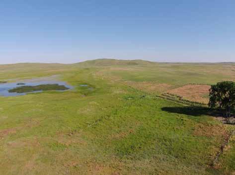
14 Property Images Mike Lashley Owner Broker Mike s Cell: mike@lashleyland.com

15 Property Images LashleyLand.com

16
17


18 Property Images Mike Lashley Owner Broker Mike s Cell: mike@lashleyland.com


19 Property Images LashleyLand.com


20 Property Images Mike Lashley Owner Broker Mike s Cell: mike@lashleyland.com

21 Property Images LashleyLand.com


22 Property Images Mike Lashley Owner Broker Mike s Cell: mike@lashleyland.com


23 Property Images Haying and branding at the Mule Shoe Bar South Ranch during the 1950 s. LashleyLand.com
24 The land experts you can trust Contact Information Office: Fax: Website: LashleyLand.com Mike Lashley, Owner Broker Scott Saults, Skip Marland, Adam Marshall, April Good Jordan Maassen, Lucy Thierer and Amy Johnston Like us on Facebook Facebook.com/LashleyLand 2218 E. Walker Road North Platte, NE Mike Lashley Owner Broker Mike s Cell: mike@lashleyland.com All information herein is from sources deemed reliable, however the accuracy is not guaranteed by Lashley Land and Recreational Brokers, Inc., seller or agent. Offering is subject to error, omissions, prior sale, price change or withdrawal without notice.
Mule Shoe Bar Beck Ranch
 Mule Shoe Bar Beck Ranch All contiguous combination pivot irrigated and rangeland consisting of 7,908 acres Property Highlights List Price $4,927,263 Location The historic Mule Shoe Bar Ranches are located
Cherry County, Nebraska
 Cherry County, Nebraska Co-Listed with Maddux Landbanc Realty, LLC Offered Exclusively By: NORTH PLATTE OFFICE P.O. Box 1166 I-80 & US Hwy 83 North Platte, NE 69103 www.agriaffiliates.com (308) 534-9240
Economic, Productive & Financial Performance Of Alberta Cow/Calf Operations
 Benchmarks for Alberta Cattlemen Economics & Competitiveness Economic, Productive & Financial Performance Of Alberta Cow/Calf Operations Comparing: Southern Alberta Total, Southern Alberta Low Cost, and
Economic, Productive & Financial Performance Of Alberta Cow/Calf Operations
 Benchmarks for Cattlemen Economics & Competitiveness Economic, Productive & Financial Performance Of Cow/Calf Operations Moist Mixed land Production Year - 1999 Nov-03 Foreword This AgriProfit$ & Returns
Alamito Creek Preserve Ranches for Sale Marfa, Presidio County, Texas
 Alamito Creek Preserve Ranches for Sale Marfa, Presidio County, Texas James King, Agent Office 432 426.2024 Cell 432 386.2821 James@KingLandWater.com Alamito Creek Preserve Various size Ranch Properties,
Budgets: 2007 planning budgets
 R5 Ranch Budgets: 2007 planning budgets Anywhere UR, Eastern Oregon File: Ray & Reba Barlow User: Bart Eleveld FINPACK Printed 10/30/2008 3:33:50 PM Crop Budget No. 1 2 3 Crop Wheat, Cash Winter Barley,
Old Thomasson Range, Chico, CA
 AG-LAND INVESTMENT BROKERS 275 Sale Lane, Suite 2 / P. O. Box 896 Red Bluff, CA 96080 530.529.4400 office / 530.527.5042 fax Old Thomasson Range, Chico, CA Property: Approximately 5,270 acres bordered
Producing Chandler Walnut Orchard
 AG-LAND Investment Brokers 275 Sale Lane Red Bluff, CA 96080 530-529-4400 Fax 530-527-5042 Producing Chandler Walnut Orchard West Sacramento Avenue - Chico, CA AG-LAND INVESTMENT BROKERS 275 Sale Lane
Fall River Valley Irrigated Farmland
 AG-LAND Investment Brokers 275 Sale Lane Red Bluff, CA 96080 530-529-4400 Fax 530-527-5042 Fall River Valley Irrigated Farmland Tehama McArthur, County, California 2015 well, 16 inch casing, 150 HP, 2,000
Quebec Ranch 12,500Acres Presidio County, Texas
 Quebec Ranch 12,500Acres Presidio County, Texas James King, Agent Office 432.426.2024 Cell 432.386.2821 James@KingLandWater.com Quebec Ranch 12,500 Acres Marfa, Presidio County, Texas James King, Agent
Sacramento River Farmland Anderson, California
 AG-LAND INVESTMENT BROKERS 275 Sale Lane / P. O. Box 896 Red Bluff, CA 96080 530.529.4400 office / 530.527.5042 fax Sacramento River Farmland Anderson, California Property: 45 +/- acres of farmland with
carpenter real estate presents:
 carpenter real estate presents: this is one of the best trophy class desert mule deer, aoudad sheep and bird hunting ranches in west texas. Elevations range from 4,400 feet to 5,180 feet. Ideal habitat
CAMARGO RANCH, llc. CRAIG BUFORD BufordResources.com
 CAMARGO RANCH, llc 2897 +/- acre Wheat & Cattle Farm Mangum, greer county, oklahoma CRAIG BUFORD 405-833-9499 BufordResources.com 4101 Perimeter Center Dr., Suite 107 Oklahoma City, OK 73112 405.833.9499
BROWN COUNTY FARMLAND AUCTION
 BROWN COUNTY FARMLAND AUCTION CROP - PASTURE - HUNTING - INVESTMENT 62 Acres +/- TUESDAY, NOVEMBER, 1 :30am Auction Location: The DEC (Dakota Event Center) - Lamont St. - Aberdeen, SD 5401 Mercier & Ravina
Name period date assigned date due date returned. Texas Ecoregions
 Name period date assigned date due date returned Directions: Go to the following website: https://www-k6.thinkcentral.com/epc/start.do Use the log in that is taped to the top of your laptop. If you are
Coyote Creek Apache County, Arizona
 Coyote Creek Apache County, Arizona Listed for sale exclusively by: Traegen Knight Headquarters West Ltd. PO BOX 1980 St. Johns, AZ 85936 Phone: (928) 524-3740, Fax: (928) 563-7004, Cell: (602) 228-3494
Cripps Ranch 76+/- Acres Orchard Development Opportunity Dixon, CA. Presented By:
 Cripps Ranch 76+/- Acres Orchard Development Opportunity Dixon, CA Presented By: Cripps Ranch 76+/- Acres Orchard Development Opportunity Dixon, CA Location: This property is located at 5663 Dally Road
South Alamito Creek Ranch
 South Alamito Creek Ranch 1500 acres, Presidio County, Texas James King, Agent Office 432-426-2024 Cell 432-386-2821 James@KingLandWater.com King Land & Water LLC P.O. Box 109, 600 State Street, Fort Davis,
Chittenden Road Prune Orchard Corning, California
 AG-LAND INVESTMENT BROKERS 275 Sale Lane / P. O. Box 896 Red Bluff, CA 96080 530.529.4400 office / 530.527.5042 fax Chittenden Road Prune Orchard Corning, California Property: 40.00 acres planted to producing
Mapping Soils, Crops, and Rangelands by Machine Analysis of Multi-Temporal ERTS-1 Data
 Purdue University Purdue e-pubs LARS Technical Reports Laboratory for Applications of Remote Sensing 1-1-1973 Mapping Soils, Crops, and Rangelands by Machine Analysis of Multi-Temporal ERTS-1 Data M. F.
MARKET WIRE. Jason Vollmer (701) Trygg Olson (701) Nick Smith (701) Adam Allmaras (701)
 Trygg Olson (701) Nick Smith (701) Adam Allmaras (701)") MARKET WIRE Quick Notes: New news in the corn market is limited. Markets continue to see spillover from Friday s USDA report. Carryout was unchanged in Friday s report and exports continue to remain sluggish.
MARKET WIRE Quick Notes: New news in the corn market is limited. Markets continue to see spillover from Friday s USDA report. Carryout was unchanged in Friday s report and exports continue to remain sluggish.
Aplomado Flats Ranch acres, Brewster County, Texas
 Aplomado Flats Ranch 2701.7 acres, Brewster County, Texas James King, Agent Office 432-426-2024 Cell 432-386-2821 James@KingLandWater.com King Land & Water LLC P.O. Box 109, 600 State Street, Fort Davis,
Table of Contents. Introduction...3 How to Use This Book...4 Standards Information...6 The World in Spatial Terms
 Table of Contents Introduction...................................................................3 How to Use This Book..........................................................4 Standards Information...........................................................6
Name period date assigned date due date returned. Texas Ecoregions
 Name period date assigned date due date returned Directions: Go to the following website: https://www-k6.thinkcentral.com/epc/start.do Use the log in that is taped to the top of your laptop. If you are
ODOR FOOTPRINTS AND THE ODOR FOOTPRINT TOOL
 ODOR FOOTPRINTS AND THE ODOR FOOTPRINT TOOL An Overview Introduction: As animal production has changed and the facilities in which livestock and poultry are raised have grown in size, neighbors of animal
NOAA and Partners Midwest and Great Plains Drought Update Webinar
 NOAA and Partners Midwest and Great Plains Drought Update Webinar Brian Fuchs National Drought Mitigation Center School of Natural Resources University of Nebraska-Lincoln NOAA Webinar Series, July 18,
For Sale at $437,500.00
 We are pleased to present Carlson Farm 72.43 ± Acres Garden City Township, Blue Earth County For Sale at $437,500.00 Listing Agent: Darrell Hylen, ALC Office: 507-345-LAND (5263) Toll Free: 800-730-LAND
Progress Report Year 2, NAG5-6003: The Dynamics of a Semi-Arid Region in Response to Climate and Water-Use Policy
 Progress Report Year 2, NAG5-6003: The Dynamics of a Semi-Arid Region in Response to Climate and Water-Use Policy Principal Investigator: Dr. John F. Mustard Department of Geological Sciences Brown University
Carrick Road $798,000
 1955-2020 Carrick Road 165.76± acres Fayette/Scott Counties $798,000 Offered Exclusively By: Zach Davis Principal Broker +1.859.576.8195 www.kirkfarms.com zach@kirkfarms.com Measuring an appx. 165+/- acres,
Quebec Ranch 12,500 acres, Presidio County
 Quebec Ranch 12,500 acres, Presidio County Quebec Ranch 12,500 Acres Marfa, Presidio County, exas James King, Agent Office 432.426.2024 James@KingLandWater.com Location he Quebec Ranch is located 25 miles
Name period date assigned date due date returned. Texas Ecoregions
 Name period date assigned date due date returned Directions: Go to the following website: https://www-k6.thinkcentral.com/epc/start.do Use the log in that is taped to the top of your laptop. If you are
POPULATION TRENDS FOR TULARE PSEUDOBAHIA AND STRIPED ADOBE LILY
 POPULATION TRENDS FOR TULARE PSEUDOBAHIA AND STRIPED ADOBE LILY Kern County has more endangered, threatened and rare plant species than most states. The geography and environmental conditions in the county
10/21/2016 Geauga County Auditors Office REALink
 10/21/2016 Geauga County Auditors Office REALink New Search Parcel Number Location Address Owner Name Acres 02 421302 9205 STAFFORD RD GOFORTH TRACEY MARIE & WELTLICH SHANNON 10.07 Main Information Map
VIKING INSPECTION PROPERTY 4921 U.S. Hwy. 85, Williston, ND 58801
 SALE PRICE: $799,000 LOT SIZE: +/-2.49 Acres BUILDING SIZE: +/-3,800 SF DRIVE-IN DOORS 2 CEILING HEIGHT: 16' YEAR BUILT: 2007 ZONING: Commercial PROPERTY OVERVIEW Highly visible, hard-to-find small shop/office/apartment
VILLAGE OF ORLAND PARK
 14700 Ravinia Avenue Orland Park, IL 60462 www.orland-park.il.us Ordinance No: File Number: 2013-0373 AN ORDINANCE ESTABLISHING SPECIAL SERVICE AREA NUMBER 3 STATE OF ILLINOIS, COUNTIES OF COOK AND WILL
Changes in Texas Ecoregions Copy the questions and answers
 Changes in Texas Ecoregions Copy the questions and answers 1. What are some kinds of damage that hurricanes cause? Roads and bridges might be washed away. Trees and power lines can be knocked down. Area
Simple Solutions Social Studies Level 2. Level 2. Social Studies. Help Pages
 Level 2 Social Studies 147 148 adobe houses with bricks made of clay and straw ancestor a family member who lived before us appoint choose; leaders can appoint others barter trading one thing for another
THE SOUTHAMPTON MARITIME. at The Lobster Inn
 DEVELOPMENT OPPORTUNITY - 1 INLET ROAD WEST, NY 11968 - OVERVIEW The site of the Lobster Inn is the entryway to the Hamptons. The development site is comprised of approximately 10 acres of residentially
Travelers usually left in May and hoped to reach Oregon by October. It took them 6 months to make the 2200-mile journey. Each wagon train headed west
 Oregon or Bust The Oregon Trail The Oregon Trail opened in 1841 with 35 men, 5 women, and 10 children using it to make the trek from Independence, Missouri, to Oregon City, Oregon. In 1842, 100 emigrants
Alamito Waters Ranch 80 acres, Presidio County, Texas James King, Agent Office Cell
 Alamito Waters Ranch 80 acres, Presidio County, Texas James King, Agent Office 432-426-2024 Cell 432-386-2821 James@KingLandWater.com King Land & Water LLC P.O. Box 109, 600 State Street, Fort Davis, TX
Urban Planning Word Search Level 1
 Urban Planning Word Search Level 1 B C P U E C O S Y S T E M P A R E U O E U R B A N P L A N N E R T N S T D H E C O U N T Y G E R E R D W R E N I C I T Y C O U N C I L A A A S U G G C I L A G P R I R
I-94 COMMERCIAL LAND ±30.44 ACRES TH ST Eau Galle, WI 54747
 PROPERTY HIGHLIGHTS + + Located off I-94 and Hwy 63 Interchange 2,900 VPD + + Baldwin-Woodville Area School District + + Zoning: Commercial, Rural Residential + + 40 miles to St. Paul + + 25 miles to Menomonie,
For Sale on Bids. Open House By Appointment
 For Sale on Bids Written Bid Deadline: Friday, September 7, by 12:00 P.M. Noon 52+/- Acres & Storage Facility Grand Forks, ND Property Location: Conveniently located off Interstate 29 and North Washington
WATERPOINT FARM INC. COMPLETE HOLSTEIN DISPERSAL. 10:00 AM Thursday, December 14, 2017 Springfield Center, New York 13468
 WATERPOINT FARM INC. COMPLETE HOLSTEIN DISPERSAL 10:00 AM Thursday, December 14, 2017 Springfield Center, New York 13468 WATERPOINT FARM INC. COMPLETE HOLSTEIN DISPERSAL Thursday, December 14, 2017 10:00
160 Acres of Tillable Land, Alfalfa, Pasture, Building Site, and Rec Area in Sun Prairie Township! Thursday, November 1, 2018 at NOON
 160+/- Acres of McCook County land 160 Acres of Tillable Land, Alfalfa, Pasture, Building Site, and Rec Area in Sun Prairie Township! Thursday, November 1, 2018 at NOON Located from Salem, SD on US HWY
A DISCOUNT MINI STORAGE
 A DISCOUNT MINI STORAGE 3735 Mangum Rd, Houston, TX 77092 High Density Mini Storage in Near NW Houston and close to newly proposed renovated US290 Highway Renovated Living Quarters, Gated Customer Access,
MARS AREA SCHOOL DISTRICT CURRICULUM GRADE: Grade 4
 MARS AREA SCHOOL DISTRICT CURRICULUM GRADE: Grade 4 Course Title: Social Studies Brief Description Overview: Students will explore the history, geography, government, and economy of the United States with
CITY OF PAPILLION PLANNING COMMISSION STAFF REPORT MAY 27, 2015 AGENDA 2015 ANNEXATION MISC
 PLANNING COMMISSION STAFF REPORT MAY 27, 2015 AGENDA 2015 ANNEXATION MISC-15-0005 I. GENERAL INFORMATION A. APPLICANT: City of Papillion 122 East Third St. Papillion, NE 68046 B. LEGAL DESCRIPTION: See
SITE-SPECIFIC HAIL ANALYSIS
 SITE-SPECIFIC HAIL ANALYSIS PREPARED FOR: Beneficial Insurance Attn: Jeff Marker June 22, 2010 Case Reference: Burke #2307IY PROJECT INFORMATION Report Completion Date: June 22, 2010 Prepared for: Beneficial
REO 100% Leased Four (4) Unit Mixed-Use Property Along Ashland
 Unit Mixed-Use Property Along Ashland") 5015 SOUTH ASHLAND AVENUE CHICAGO, IL 60609 DETAILS Sale Price $119,000 Lot Size 0.06 Acres Building Size 3,784 SF Occupancy 100% Year Built 1893 Market Cook County Sub Market South Chicago Cross Streets
5015 SOUTH ASHLAND AVENUE CHICAGO, IL 60609 DETAILS Sale Price $119,000 Lot Size 0.06 Acres Building Size 3,784 SF Occupancy 100% Year Built 1893 Market Cook County Sub Market South Chicago Cross Streets
Following the Civil War, many Americans and Europeans continued to move into the WEST
 1860-1900 Following the Civil War, many Americans and Europeans continued to move into the WEST as far as the eye can see millions of acres of treeless grassland. Between the Mississippi River and the
TRINITY COUNTY. Board Item Request Form Phone
 County Contract No. Department Board of Supervisors TRINITY COUNTY 6.01 Board Item Request Form 2014-08-12 Contact Judy Pflueger Phone 623-1217 Requested Agenda Location County Matters Requested Board
Steve Pye LA /22/16 Final Report: Determining regional locations of reference sites based on slope and soil type. Client: Sonoma Land Trust
 Steve Pye LA 221 04/22/16 Final Report: Determining regional locations of reference sites based on slope and soil type. Client: Sonoma Land Trust Deliverables: Results and working model that determine
Archway Learning Trust. Mathematics Department. Year 11 Mock 2 (February 2019) Foundation Tier. Paper 2. Name: Teacher:
 Foundation Tier. Paper 2. Name: Teacher:") Name: Teacher: Archway Learning Trust Mathematics Department Year 11 Mock 2 (February 2019) Foundation Tier Paper 2 Materials: For this paper you must have: A scientific calculator Mathematical instruments
Name: Teacher: Archway Learning Trust Mathematics Department Year 11 Mock 2 (February 2019) Foundation Tier Paper 2 Materials: For this paper you must have: A scientific calculator Mathematical instruments
Chapter 3. Description of the Study Area. Karl Taboga, James Stafford and Paul Taucher 3-19
 Chapter 3 Description of the Study Area Karl Taboga, James Stafford and Paul Taucher 3-19 T his study examines groundwater resources that underlie the Bear River drainage basin in Wyoming as well as areas
CALIFORNIA AGRICULTURAL PR OPERTIES, IN C. BOWLSBEY 320 LIBERTY ISLAND ROAD BUYER: RASSMUSSEN TRUST
 CALIFORNIA AGRICULTURAL PR OPERTIES, IN C. BOWLSBEY 320 LIBERTY ISLAND ROAD SELLER: BOWLSBEY TRUST BUYER: RASSMUSSEN TRUST LOCATION: The Bowlsbey 320 is located ten (10) miles southeast of the City of
EBIPM Curriculum. Unit Pre/Post test. Module 1 Test. Rangeland ecosystems
 Module 1 Test. Rangeland ecosystems EBIPM Curriculum Unit Pre/Post test Species Identification - Label the species pictured with the correct name. (2 points each) 1 2 1 Mark W. Skinner. USDA, NRCS. 2011.
Crop Enterprise Budget Sugar Beets, Thick-Planted, Wheatland Area
 Crop Enterprise Budget Sugar Beets, Thick-Planted, Wheatland Area John P. Hewlett, Farm/Ranch Management Extension Specialist Chris Bastian, Research Associate MP-72.3 University of Wyoming - August, 1994
The Climate of Marshall County
 The Climate of Marshall County Marshall County is part of the Crosstimbers. This region is a transition region from the Central Great Plains to the more irregular terrain of southeastern Oklahoma. Average
Chapter 1 Homework - Elements of Real Estate Law
 Chapter 1 Homework - Elements of Real Estate Law The following questions are a small example of what you might expect to see on the Real Estate Law portion of the Cadastral Mapping exam. First try answering
CONGLETON INDUSTRIAL PARK LT 6 EX W 300' & E 350' LT 7 BLK 1, a subdivision of land in the City of Overland Park, Johnson County, Kansas.
 NOTICE OF PUBLIC HEARING CITY PLANNING COMMISSION CITY OF OVERLAND PARK, KANSAS Notice is hereby given that the City Planning Commission of Overland Park, Kansas, will hold a public hearing Monday, July
Karl Reichle. Mark Owens. and. present :
 Connecticut s own Karl Reichle and Mark Owens present : Hey, Where s Connecticut? Cell phones If yours goes off, Don t worry,we know what you do for a living. Just step out into the hall and take care
Southwest Drought Webinar. Becky Bolinger, Assistant State Climatologist Colorado Climate Center June 25, 2018
 Southwest Drought Webinar Becky Bolinger, Assistant State Climatologist Colorado Climate Center June 25, 2018 COLORADO CLIMATE CENTER Current Drought U.S. Drought Monitor Drought evolution COLORADO CLIMATE
KC Retail Report Second Quarter, 2018
 KC Retail Report Second Quarter, 2018 Overview Kansas City s Increases to 5.6% Net Absorption Negative (78,433) SF in the Quarter The Kansas City retail market did not experience much change in market
Northwest FCS - Non-Producing Property Report Create Date: 10/30/2018
 Page 1 of 15 County: ADA 1 10 002N 001E NW4SW4 13 10016 MINERAL 40.00 0.5000000 20.00 2 10 002N 001E NW4 14 10017 MINERAL 160.00 0.5000000 80.00 3 09 003N 001E PART OF THE S2: LYING N OF THE RR R/W 18
NIDIS Intermountain West Drought Early Warning System April 18, 2017
 1 of 11 4/18/2017 3:42 PM Precipitation NIDIS Intermountain West Drought Early Warning System April 18, 2017 The images above use daily precipitation statistics from NWS COOP, CoCoRaHS, and CoAgMet stations.
Schuyler County Idle Farmland Analysis. Conducted by Cornell Cooperative Extension of Schuyler County
 Schuyler County Idle Farmland Analysis Conducted by Cornell Cooperative Extension of Schuyler County June 15, 2010 Schuyler County Idle Farmland Analysis Purpose: The purpose of this analysis is to approximate
VILLAGE OF ORLAND PARK
 14700 Ravinia Avenue Orland Park, IL 60462 www.orland-park.il.us Ordinance No: File Number: 2013-0239 AN ORDINANCE PROPOSING THE ESTABLISHMENT OF SPECIAL SERVICE AREA NUMBER 2 IN THE, AND PROVIDING FOR
Conceptual model Source: Knight, 1994
 Rangelands Conceptual model Source: Knight, 1994 What are rangelands? Task (3 minute each) Why are rangelands important? Why are rangelands important? Livestock Production Forage Wildlife Habitat Recreation
Grade Level, Course Third Grade Social Studies PLSD Balanced Assessment Practices. Type* DOK
 Unit Guides Assessment Items Indic ator s Concept Standard Curricular Indicator DOK Type* SR CR PB Assessment Questions # DOK Level 1E 1M 1H 2E 2M 2H 3E 3M 3H Civics Students will develop and apply the
National Wildland Significant Fire Potential Outlook
 National Wildland Significant Fire Potential Outlook National Interagency Fire Center Predictive Services Issued: September, 2007 Wildland Fire Outlook September through December 2007 Significant fire
The Climate of Murray County
 The Climate of Murray County Murray County is part of the Crosstimbers. This region is a transition between prairies and the mountains of southeastern Oklahoma. Average annual precipitation ranges from
2015 Costs and Returns Estimate Eastern Idaho: Alfalfa Hay Establishment in Grain Stubble Paul E. Patterson Background and Assumptions
 2015 Costs and Returns Estimate Eastern Idaho: Alfalfa Hay Establishment in Grain Stubble Paul E. Patterson Background and Assumptions Eastern Idaho The University of Idaho s costs and returns estimates
Cook Road Ridgeway, South Carolina
 For Sale or Ground Lease ±66.0 AC Industrial Land k Rd Coo Cook Road Ridgeway, South Carolina THE INFORMATION CONTAINED HEREIN HAS BEEN GIVEN TO US BY THE OWNER OF THE PROPERTY OR OTHER SOURCES WE DEEM
E XTREME D ROUGHT An oppressive, long-term
 E XTREME D ROUGHT 2006-2008 An oppressive, long-term drought lasting from late March of 2006 until late August of 2008 impacted the entire state of Florida, with costly consequences in residential water
Information Paper. Kansas City District. Missouri River Fish and Wildlife Mitigation Project Jim and Olivia Hare Wildlife Area, MO
 City District Information Paper River Fish and Wildlife Mitigation Project Jim and Olivia Hare Wildlife Area, MO Riverine habitat created in 2004/2005 by modifying existing river structures along the banks,
Former Guterl Specialty Steel Site
 Former Guterl Specialty Steel Site Environmental Monitoring Report 2013-2014 U. S. ARMY CORPS OF ENGINEERS BUILDING STRONG Buffalo District Formerly Utilized Sites Remedial Action Program May 2015 Site
The Climate of Payne County
 The Climate of Payne County Payne County is part of the Central Great Plains in the west, encompassing some of the best agricultural land in Oklahoma. Payne County is also part of the Crosstimbers in the
Six (6) Unit Apartment Building Along Garfield Boulevard - Bank Owned WEST GARFIELD BOULEVARD CHICAGO, IL DETAILS PROPERTY OVERVIEW
 Unit Apartment Building Along Garfield Boulevard - Bank Owned WEST GARFIELD BOULEVARD CHICAGO, IL DETAILS PROPERTY OVERVIEW") 907-909 WEST GARFIELD BOULEVARD CHICAGO, IL 60621 DETAILS Sale Price $370,000 Lot Size 7,500 SF Building Size 8,538 SF Taxes (2016) $6,021.31 Zoning R-1, Low Density Residential Market South Chicago Cross
907-909 WEST GARFIELD BOULEVARD CHICAGO, IL 60621 DETAILS Sale Price $370,000 Lot Size 7,500 SF Building Size 8,538 SF Taxes (2016) $6,021.31 Zoning R-1, Low Density Residential Market South Chicago Cross
UNITED STATES AND SOUTH AMERICA OUTLOOK (FULL REPORT) Wednesday, April 18, 2018
 Wednesday, April 18, 2018") T-storm Weather Summary Coolness continues over the next week in much of the central U.S., most likely producing the coldest April since 1907 in the Corn Belt, but followed by seasonable to mild weather
T-storm Weather Summary Coolness continues over the next week in much of the central U.S., most likely producing the coldest April since 1907 in the Corn Belt, but followed by seasonable to mild weather
The Effect of the No-Burn Ban on the Economic Viability of Producing Bluegrass Seed in Select Areas of Washington State
 Farm Business Management Reports EB1922E The Effect of the No-Burn Ban on the Economic Viability of Producing Bluegrass Seed in Select Areas of Washington State Herbert R. Hinman Alan Schreiber Online
Arizona Drought Monitoring Sensitivity and Verification Analyses
 Arizona Drought Monitoring Sensitivity and Verification Analyses A Water Sustainability Institute, Technology and Research Initiative Fund Project Christopher L. Castro, Francina Dominguez, Stephen Bieda
MILLS COUNTY, IOWA FARMLAND FOR SALE PRICE REDUCED
 MILLS COUNTY, IOWA FARMLAND FOR SALE PRICE REDUCED Owners: Riverdale Farm Corp. Acres: 302.59 Legal Description: Location: Description: See Attached From I-29/Highway 370 exit, 1 ¾ Miles west on Highway
U.S. Baseline Lamb Cost of Production Model
 U.S. Baseline Lamb Cost of Production Model LMIC WORKING GROUP: Coordinator: Bridger Feuz, University of Wyoming Member Cooperators: Tim Petry, North Dakota State University; David Anderson, Texas A&M
Fairfield Hill Road Winnsboro, South Carolina
 Fairfield Hill Road Winnsboro, South Carolina Tom Milliken +1 803 331 6999 tmilliken@naiavant.com Tombo Milliken +1 803 206 8384 tombo.milliken@naiavant.com THE INFORMATION CONTAINED HEREIN HAS BEEN GIVEN
Sea Level Rise and the Scarborough Marsh Scarborough Land Trust Annual Meeting April 24, 2018
 Sea Level Rise and the Scarborough Marsh Scarborough Land Trust Annual Meeting April 24, 2018 Peter A. Slovinsky, Marine Geologist Maine Geological Survey Funded by: 50% 40% Figure modified from Griggs,
Outage Coordination and Business Practices
 Outage Coordination and Business Practices 1 2007 Objectives What drove the need for developing a planning/coordination process. Why outage planning/coordination is crucial and important. Determining what
CALIFORNIA AGRICULTURAL PR OPERTIES, IN C. GALE RANCH
 CALIFORNIA AGRICULTURAL PR OPERTIES, IN C. GALE RANCH LOCATION: The Ranch is located 6 Yi miles west of the City of Davis on the northwest corner of County Roads 29A and 92E in Yolo County. SIZE: 368.64
Cold-Read Task. b. The author emphasizes how the drought caused people to be afraid to shake hands.
 Cold-Read Task Read Legacy from The Dust Bowl. Then answer the questions. 1. Part A Read paragraph 3 of Legacy. Then the drought began. It would last eight straight years. Dust storms, at first considered
The Climate of Texas County
 The Climate of Texas County Texas County is part of the Western High Plains in the north and west and the Southwestern Tablelands in the east. The Western High Plains are characterized by abundant cropland
UNITED STATES AND SOUTH AMERICA WEATHER ROUNDUP Sunday, December 17, 2017
 T-storm Weather Summary Extreme heat was followed by heavy rain in some key areas of Argentina yesterday. T-storms affect much of the driest Argentina, southern Brazil, and Paraguay through 7 to 10 days,
MINERAL MOUNTAIN RESOURCES LTD. MMV.TSX-V
 MINERAL MOUNTAIN RESOURCES LTD. 201-1416 West 8 th Avenue Vancouver, B.C. V6H 1E1 T: 604-714-0111 F: 604-714-1119 MMV.TSX-V NEWS RELEASE March 3, 2011 No. 2011-04 MINERAL MOUNTAIN DRILLS 3.17 g/t OVER
Jernigans Mobile Home Community 103 Spring Street, Grovetown, GA 30813
 EXECUTIVE SUMMARY OFFERING SUMMARY Sale Price: $600,000 Number Of Units: 21 Cap Rate: 9.4% NOI: $66,895 Lot Size: 2.7 Acres Building Size: 23,000 PROPERTY OVERVIEW 21 Space park. All units are park owned
Grade Five Social Studies Assessment Regions/Native Americans
 Name Grade Five Social Studies Assessment Regions/Native Americans Use the map below to answer questions 1 and 2 1. (Geo 1) For this location give the name of the city found there. 38 N, 100 W a. Scottsbluff
Borchert s Epochs of American Urbanization
 Borchert s Epochs of American Urbanization Geographers define cities as intersecting points of communication and transportation. Cities serve multiple social, political, economic and cultural purposes.
Written by Vowery Dodd Carlile and Traci Burnett Illustrated by Karen Birchak
 Written by Vowery Dodd Carlile and Traci Burnett Illustrated by Karen Birchak Table of Contents INTRODUCTION...5 TO THE TEACHER...6 STORIES ABOUT TEXAS: Background, Vocabulary Activities, Discussion Questions,
Paul Patterson Background and Assumptions
 2015 Costs and Returns Estimate Southcentral Idaho: Magic Valley Alfalfa Hay Production Paul Patterson Background and Assumptions Magic Valley The University of Idaho s costs and returns estimates are
Mercer County Census Data (10% Sample)
") Total Number of s Sample Number of s Owners Rents for Money Rents for Crop Percent of s Operated by Owner Percent of Tenancy Tilled Acres Cool Spring 143 14 10 1 3 71 29 653 Deer Creek 107 11 11 0 0 100
Total Number of s Sample Number of s Owners Rents for Money Rents for Crop Percent of s Operated by Owner Percent of Tenancy Tilled Acres Cool Spring 143 14 10 1 3 71 29 653 Deer Creek 107 11 11 0 0 100
Background and Assumptions
 2017 Costs and Returns Estimate Southcentral Idaho: Magic Valley Alfalfa Hay Production Ben Eborn Magic Valley Background and Assumptions The University of Idaho s costs and returns estimates are based
For Sale - 56 Acre Sandstone Quarry State Route 511, Oberlin/Kipton, OH 44075
 14647 State Route 511, Oberlin/Kipton, OH 44075 56 ACRES Vermilion Rd Gifford Rd Haigh Rd 44 Summary The Kipton sandstone quarry is included in 56 acre tract owned by Terry A. Johnson, of Huron, Ohio.