Mule Shoe Bar Beck Ranch
|
|
|
- August Allen
- 5 years ago
- Views:
Transcription


1 Mule Shoe Bar Beck Ranch All contiguous combination pivot irrigated and rangeland consisting of 7,908 acres
2 Property Highlights List Price $4,927,263 Location The historic Mule Shoe Bar Ranches are located in the western tier of the famed Nebraska Sandhills approximately 25 miles southeast from Alliance, Nebraska or approximately 30 miles north from Lisco, Nebraska. Description The East Coast Holdings Mule Shoe Bar Ranches are made up of three separate ranches all within two miles of each other and all with direct access to county roadways. Each ranch can be operated separately, or if desired, operated as one ranch. The Mule Shoe Bar North Ranch is comprised of approximately 3, deeded acres by county record. The Mule Shoe Bar Beck Ranch is comprised of approximately 7, deeded acres by county record. The Mule Shoe Bar South Ranch is comprised of approximately 11, deeded acres by county record. Total approximate acreage among the three ranches is 22,962 deeded acres. Nebraska Sandhills The Mule Shoe Bar Ranches are located in the western region of the famed Nebraska Sandhills, known for one of the finest cattle producing regions in the United States. The Sandhills of Nebraska is the Nation s largest undisturbed native grassland area. It covers approximately 13 million acres in 20 counties located in the north central part of the state. The grasses are vigorous and nutritious and have proven themselves as drought tolerant species centuries ago by supporting vast herds of Buffalo prior to the arrival of the white man. Ogallala Aquifer The Sandhills of Nebraska also sits on top of the largest fresh water aquifer in the continental U.S. Known as the Ogallala or High Plains Aquifer, it supports fresh water bearing material where this ranch is located in the range of in depth. Stock wells and irrigation wells are generally considered shallow by comparison to other cattle producing regions in other states. Rainfall The rainfall belt in the area and location of these ranches, ranges from per year, with the majority of it falling during the grass growing season. Rain is generally considered consistent and reliable, to the extent that cattle sell downs because of drought are rare. Markets The ranches are well located to auction barns in Ogallala and Gordon, Nebraska. Ogallala supports one of the finest livestock sale barns in the state of Nebraska. Thousands of reputation cattle pass through its gates annually in the form of special stock cow, bred heifer, yearling, and calf sales throughout the year. Buyers from several states are always on hand to create a consistent, top-end market for all classes of cattle. There are also video auction markets available that are nationwide in scope. Economies of Scale The sum of the three ranch resources will make an economically sized unit that will easily support a family along with hired or contract labor. Minerals The current ownership will convey all the owned minerals. Exchanges The current ownership will cooperate with 1031 exchanges. Approach to Management and Revenue All three Mule Shoe Bar Ranches under the current ownership have been utilized by grazing. In the analysis and use of the three resources, grazing has also been the predominant use. However, both the Beck Ranch and the South Ranch possess sub irrigated range sites, some of which could be routinely hayed each summer; if the owner chose to have a balance of hay on hand for the winter months. The USDA NRCS has developed and provided both ranch range site maps with estimated acreages as well as an animal unit study for each ranch. These studies have been utilized in determining the estimated carrying capacities of each ranch resource. What follows are each of the ranches estimates of deeded acres and current real estate taxes from the respective counties; as well as the NRCS estimates of
3 Property Highlights acres, range sites, carrying capacity AUMs under average use, number of pastures, and number of stock wells. Each ranch has been evaluated for annual carrying capacity and an estimate of landlord revenue generation on a summer grazing basis utilizing cow-calf pairs. MULE SHOE BAR BECK RANCH: Description: An all contiguous combination center pivot irrigated and rangeland resource with some sub irrigated rangeland sites with a modest set of building improvements. Ranch has 14 pastures and 17 stock wells. A combination of county acres and NRCS* acres were utilized for this analysis. Deeded acres by County Record: 7, acres 2015 Real Estate Taxes by County Record: $24, Land Classification Summary Estimated Acres by County Record and NRCS* Center Pivot Irrigated Hayed: 136 ac* Sub Irrigated/Sandy lowland Hayed 177 ac* Sub Irrigated/Sandy lowland Grazed: 783 ac* Sandhill Rangeland: 6110 ac* Lake/Marsh: 698 ac* Bldg. Site & Lots: 5 ac* Total estimated acres by county record: 7909 ac Landlord Revenue Estimate 136 acres* center pivot irrigated AUMs/Ton 1,360 AUMS* 177 acres* sub irrigated/sandy lowland hayed AUMS/Ton 445 AUMs* (313 acres*) aftermath grazing 74 AUMs 6893 acres* sub irrigated/sandy lowland/sandhill rangeland grazed 3572 AUMs* 698 acres* of lake and marsh 5 acres* building site 7,909 acres total by county record 5451 AUMs 5451/12 months 454 AUs or 17 acres/au $60/Ton/2 - $16,320 or $120/ac CE 177 acres hayed 178 $60/Ton/2 - $5,340 or $30/ac CE (includes aftermath) 3572 AUMs/5 months/1.5 BWE 476 pair or 15 ac/pair 476 $55/pair/month for 5 months - $130,900 or $19/ac CE $152,560 Gross Income $24,905 RE Taxes $16,000 R & R $1,500 Misc. $110,155 Net Income, Say $110,000 Net to Landlord Year Around Carrying Capacity Estimate 5451 AUMs/12 Mo 454 AUs Winter 1805 AUMs/4 mo 451 AUs Spring/Summer/Fall 3646 AUMs/8 mo -456 AUs 456 AUs cows (cow calf, retaining replacements, bulls) 7909 ac/456 AU 17 ac/au 7909 ac/365 Cows 22 ac/cow LashleyLand.com
4 Property Highlights History The Mule Shoe Bar Ranches have a previous ownership history that dates back prior to the last century. A family of brothers by the name of Peterson settled in this area of the Sandhills, and proceeded to acquire land via homestead and purchase over the years and their lifetimes. Mule Shoe Bar was one of the ranch names with a brand that went with it. They ended up being some of the largest land owners in this area of the Sandhills joining other names such as Abbott, Black, Hord and Eldred, all of which including the Peterson Brothers, built ranching empires in their own names. Some of the original Peterson ownership is still currently held by their third and fourth generations today. Peterson Brothers stories have been passed down and shared through the generations of Sandhill families. One such story was about the Peterson Hay Trains. During the summer hay season the brothers would team up and share their resources to put up each other s hay meadows for winter feed. Horses, mules, hired men, and horse drawn hay equipment were all brought together to form a large hay crew that worked from the hay train during the summer months. The hay train consisted of several wagons each dedicated to a special purpose to get the hay put up. There could be as many as 5-6 wagons all connected together and pulled by a large team of many mules or horses. The first wagon was generally the straw boss quarters, second wagon, the cook house, third wagon the supply wagon, the fourth and fifth wagons the bunk house wagons and the last wagon the hay supplies wagon. This operation was self-contained with food and supplies for generally several weeks at a time with hay crew, horses, mules and the hay train traveling over thousands of acres putting up hay wherever the Peterson Brothers would want it put up. Spring brandings were also often completed with Peterson ranch shared cowboys. It was a good way to stay social in a day when your only means of transportation was by horseback for the average ranch cowboy working for wages at $25/month or by horse and buggy if you owned the ranch. Broker Comments These are three excellent producing, reputation Sandhill ranches that have only been on the market for a second time in over 100 years. They would not be for sale now if the current ownership did not have opportunities to purchase other land closer to their parent operations. Legal Descriptions Mule Shoe Bar Beck Ranch: Township 22 North, Range 45 West of the 6 th P.M., Garden County, Nebraska: Section 1: NW1/4NW1/4-Lot 4 Section 2: ALL Section 3: PT SE1/4 Section 10: NE1/4 Section 11: ALL Township 23 North, Range 45 West of the 6 th P.M., Garden County, Nebraska: Section 13: S1/2 Section 14: S1/2 Section 15: S1/2 Section 16: W1/2SW1/4 Section 17: S1/2N1/2, S1/2 Section 20: ALL Section 21: N1/2, N1/2S1/2, SW1/4SW1/4 Section 22: NW1/4, N1/2NE1/4, N1/2SW1/4 Section 23: N1/2NE1/4, NE1/4NW1/4, NW1/4NW1/4, S1/2NE1/4, SE1/4 Section 24: ALL Section 25: ALL Section 26: S1/2, NE1/4 Section 35: ALL
5 LANd Inventory By County Record Land Inventory by County Record Garden County 2015 Description Grass Water Irrigated Bld Roads Waste Total Taxes Site Mule Shoe Bar Beck Ranch NW1/4NW1/4-Lot $98.92 ALL $1, PT SE1/ $ NE1/ $ ALL $1, S1/ $1, S1/2N1/2, S1/ $3, ALL $2, N1/2, N1/2S1/2, SW1/4SW1/ $1, NW1/4, N1/2NE1/4, N1/2SW1/ $ N1/2NE1/4, NE1/4NW1/ $ NW1/4NW1/4, S1/2NE1/4, SE1/ $ ALL $1, ALL $1, S1/2, NE1/ $1, ALL $1, S1/ $1, S1/ $1, W1/2SW1/ $91.62 Total 7, $24, All information herein is from sources deemed reliable, however the accuracy is not guaranteed by Lashley Land and Recreational Brokers, Inc., seller or agent. Offering is subject to error, omissions, prior sale, price change or withdrawal without notice. LashleyLand.com

6 Aquifer Map Mule Shoe Bar Ranches

7 Vegetation Map Mule Shoe Bar Ranches The Sandhills area of Nebraska is the Nation s largest undisturbed native grassland. It covers 13 million acres in 20 counties in the north central part of the State. As the name implies, it is an area of fine, windblown sand which, without the heavy cover of grass, would be an expanse of moving sand dunes. The roots of these grasses can penetrate 3-5, which allow it to thrive on the abundant groundwater. The Sandhills area is recognized as one of the nation s finest for livestock production. The grasses are a vigorous and nutritious species that supported the vast herds of bison in the days before the coming of the settlers. LashleyLand.com
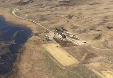
8 Aerial Map - All Ranches Mule Shoe Bar North Ranch Mule Shoe Bar Beck Ranch Mule Shoe Bar South Ranch Boundary lines are estimates - Map for illustration only
9 Location Map - All Ranches Mule Shoe Bar North Ranch Mule Shoe Bar Beck Ranch Mule Shoe Bar South Ranch Boundary lines are estimates - Map for illustration only LashleyLand.com
10 Location From nearest towns Alliance Rd 155 Lisco Boundary lines are estimates - Map for illustration only
11 Area Lakes and topography Boundary lines are estimates - Map for illustration only Sources: Esri, HERE, DeLorme, TomTom, Intermap, increment P Corp., USGS, FAO, NPS, NRCAN, GeoBase, IGN, Kadaster NL, Ordnance Su Japan, METI, Esri China (Hong Kong), swisstopo, MapmyIndia, LashleyLand.com

12 Beck Ranch With Roads Boundary lines are estimates - Map for illustration only

13 Beck Ranch Conservation Map Boundary lines are estimates - Map for illustration only LashleyLand.com

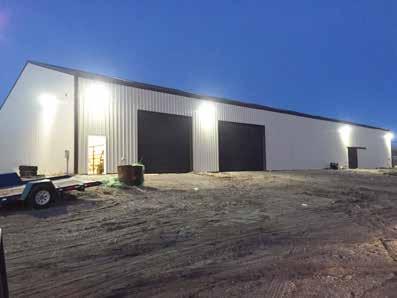
14 Property Images


15 Property Images LashleyLand.com
16 Property Images

17 Property Images LashleyLand.com


18 Property Images


19 Property Images LashleyLand.com


20 Property Images


21 Property Images LashleyLand.com


22 Property Images


23 Property Images Haying and branding at the Mule Shoe Bar Ranches during the 1950 s. LashleyLand.com
24 The land experts you can trust Contact Information Office: Fax: Website: LashleyLand.com, Scott Saults, Skip Marland, Adam Marshall, April Good Jordan Maassen, Lucy Thierer and Amy Johnston Like us on Facebook Facebook.com/LashleyLand 2218 E. Walker Road North Platte, NE All information herein is from sources deemed reliable, however the accuracy is not guaranteed by Lashley Land and Recreational Brokers, Inc., seller or agent. Offering is subject to error, omissions, prior sale, price change or withdrawal without notice.
Mule Shoe Bar South Ranch
 Mule Shoe Bar South Ranch All contiguous rangeland with sub irrigated range sites consisting of 11,555 total acres Mike Lashley Owner Broker Mike s Cell: 308-530-0134 Email: mike@lashleyland.com Property
Cherry County, Nebraska
 Cherry County, Nebraska Co-Listed with Maddux Landbanc Realty, LLC Offered Exclusively By: NORTH PLATTE OFFICE P.O. Box 1166 I-80 & US Hwy 83 North Platte, NE 69103 www.agriaffiliates.com (308) 534-9240
Land cover modeling in the Travis County
 Land cover modeling in the Travis County Contents Introduction.1 Data collection 3 Data pre-processing 6 Land cover modeling 12 Final considerations 13 Prepared for: GIS and Water Resources By Julie C
Economic, Productive & Financial Performance Of Alberta Cow/Calf Operations
 Benchmarks for Alberta Cattlemen Economics & Competitiveness Economic, Productive & Financial Performance Of Alberta Cow/Calf Operations Comparing: Southern Alberta Total, Southern Alberta Low Cost, and
Economic, Productive & Financial Performance Of Alberta Cow/Calf Operations
 Benchmarks for Cattlemen Economics & Competitiveness Economic, Productive & Financial Performance Of Cow/Calf Operations Moist Mixed land Production Year - 1999 Nov-03 Foreword This AgriProfit$ & Returns
Budgets: 2007 planning budgets
 R5 Ranch Budgets: 2007 planning budgets Anywhere UR, Eastern Oregon File: Ray & Reba Barlow User: Bart Eleveld FINPACK Printed 10/30/2008 3:33:50 PM Crop Budget No. 1 2 3 Crop Wheat, Cash Winter Barley,
Alamito Creek Preserve Ranches for Sale Marfa, Presidio County, Texas
 Alamito Creek Preserve Ranches for Sale Marfa, Presidio County, Texas James King, Agent Office 432 426.2024 Cell 432 386.2821 James@KingLandWater.com Alamito Creek Preserve Various size Ranch Properties,
Old Thomasson Range, Chico, CA
 AG-LAND INVESTMENT BROKERS 275 Sale Lane, Suite 2 / P. O. Box 896 Red Bluff, CA 96080 530.529.4400 office / 530.527.5042 fax Old Thomasson Range, Chico, CA Property: Approximately 5,270 acres bordered
2 Groundwater Basin Monitoring
 Zone 7 Water Agency 2 Groundwater Basin Monitoring Programs 2.1 Climatological Monitoring 2 Groundwater Basin Monitoring Programs This section describes Zone 7's Climatological Monitoring Program which
Quebec Ranch 12,500Acres Presidio County, Texas
 Quebec Ranch 12,500Acres Presidio County, Texas James King, Agent Office 432.426.2024 Cell 432.386.2821 James@KingLandWater.com Quebec Ranch 12,500 Acres Marfa, Presidio County, Texas James King, Agent
Producing Chandler Walnut Orchard
 AG-LAND Investment Brokers 275 Sale Lane Red Bluff, CA 96080 530-529-4400 Fax 530-527-5042 Producing Chandler Walnut Orchard West Sacramento Avenue - Chico, CA AG-LAND INVESTMENT BROKERS 275 Sale Lane
Fall River Valley Irrigated Farmland
 AG-LAND Investment Brokers 275 Sale Lane Red Bluff, CA 96080 530-529-4400 Fax 530-527-5042 Fall River Valley Irrigated Farmland Tehama McArthur, County, California 2015 well, 16 inch casing, 150 HP, 2,000
Streams in the Ranching Country of South Texas
 Streams in the Ranching Country of South Texas Watershed Analysis of HUC 12110207 Sandranell Moerbe CE GIS in Water Resources Fall 2015 INTRODUCTION This project investigates the portion of South Texas
BROWN COUNTY FARMLAND AUCTION
 BROWN COUNTY FARMLAND AUCTION CROP - PASTURE - HUNTING - INVESTMENT 62 Acres +/- TUESDAY, NOVEMBER, 1 :30am Auction Location: The DEC (Dakota Event Center) - Lamont St. - Aberdeen, SD 5401 Mercier & Ravina
Sacramento River Farmland Anderson, California
 AG-LAND INVESTMENT BROKERS 275 Sale Lane / P. O. Box 896 Red Bluff, CA 96080 530.529.4400 office / 530.527.5042 fax Sacramento River Farmland Anderson, California Property: 45 +/- acres of farmland with
carpenter real estate presents:
 carpenter real estate presents: this is one of the best trophy class desert mule deer, aoudad sheep and bird hunting ranches in west texas. Elevations range from 4,400 feet to 5,180 feet. Ideal habitat
Coyote Creek Apache County, Arizona
 Coyote Creek Apache County, Arizona Listed for sale exclusively by: Traegen Knight Headquarters West Ltd. PO BOX 1980 St. Johns, AZ 85936 Phone: (928) 524-3740, Fax: (928) 563-7004, Cell: (602) 228-3494
Table of Contents. Introduction...3 How to Use This Book...4 Standards Information...6 The World in Spatial Terms
 Table of Contents Introduction...................................................................3 How to Use This Book..........................................................4 Standards Information...........................................................6
1 foot of Sea Level Rise
 1 foot of Sea Level Rise Schools Fire Stations $+ Law Enforcement u Hospitals 1ft SLR 0 0.25 0.55 1.1 Miles $+ Year 20 Population: the 2013 study A Geological Perspective U.S. Mid-Atlantic Coast a probable
Chittenden Road Prune Orchard Corning, California
 AG-LAND INVESTMENT BROKERS 275 Sale Lane / P. O. Box 896 Red Bluff, CA 96080 530.529.4400 office / 530.527.5042 fax Chittenden Road Prune Orchard Corning, California Property: 40.00 acres planted to producing
Name period date assigned date due date returned. Texas Ecoregions
 Name period date assigned date due date returned Directions: Go to the following website: https://www-k6.thinkcentral.com/epc/start.do Use the log in that is taped to the top of your laptop. If you are
Aplomado Flats Ranch acres, Brewster County, Texas
 Aplomado Flats Ranch 2701.7 acres, Brewster County, Texas James King, Agent Office 432-426-2024 Cell 432-386-2821 James@KingLandWater.com King Land & Water LLC P.O. Box 109, 600 State Street, Fort Davis,
2 Precipitation and Evaporation
 Zone 7 Water Agency 2.1 Program Description 2 Precipitation and Evaporation This section describes Zone 7's Climatological Monitoring Program which tracks rainfall and evaporation in the Valley. Zone 7
Cripps Ranch 76+/- Acres Orchard Development Opportunity Dixon, CA. Presented By:
 Cripps Ranch 76+/- Acres Orchard Development Opportunity Dixon, CA Presented By: Cripps Ranch 76+/- Acres Orchard Development Opportunity Dixon, CA Location: This property is located at 5663 Dally Road
South Alamito Creek Ranch
 South Alamito Creek Ranch 1500 acres, Presidio County, Texas James King, Agent Office 432-426-2024 Cell 432-386-2821 James@KingLandWater.com King Land & Water LLC P.O. Box 109, 600 State Street, Fort Davis,
MARKET WIRE. Jason Vollmer (701) Trygg Olson (701) Nick Smith (701) Adam Allmaras (701)
 Trygg Olson (701) Nick Smith (701) Adam Allmaras (701)") MARKET WIRE Quick Notes: New news in the corn market is limited. Markets continue to see spillover from Friday s USDA report. Carryout was unchanged in Friday s report and exports continue to remain sluggish.
MARKET WIRE Quick Notes: New news in the corn market is limited. Markets continue to see spillover from Friday s USDA report. Carryout was unchanged in Friday s report and exports continue to remain sluggish.
Mapping Soils, Crops, and Rangelands by Machine Analysis of Multi-Temporal ERTS-1 Data
 Purdue University Purdue e-pubs LARS Technical Reports Laboratory for Applications of Remote Sensing 1-1-1973 Mapping Soils, Crops, and Rangelands by Machine Analysis of Multi-Temporal ERTS-1 Data M. F.
CAMARGO RANCH, llc. CRAIG BUFORD BufordResources.com
 CAMARGO RANCH, llc 2897 +/- acre Wheat & Cattle Farm Mangum, greer county, oklahoma CRAIG BUFORD 405-833-9499 BufordResources.com 4101 Perimeter Center Dr., Suite 107 Oklahoma City, OK 73112 405.833.9499
1 foot of Sea Level Rise
 1 foot of Sea Level Rise Schools Fire Stations Law Enforcement u Hospitals 1ft SLR 0 0.125 0.25 0.5 Miles the 2013 study A Geological Perspective U.S. Mid-Atlantic Coast a probable threat expected by 2050.
IMAGE ANALYSIS MEASURING LANDSCAPE VEGETATION IN 1.3 MILLION PARCELS FOR OUTDOOR WATER BUDGETS
 IMAGE ANALYSIS MEASURING LANDSCAPE VEGETATION IN 1.3 MILLION PARCELS FOR OUTDOOR WATER BUDGETS Pete Vitt Santa Ana Watershed Project Authority (SAWPA) Doug Mende Statistical Research Inc. July 13, 2017
Progress Report Year 2, NAG5-6003: The Dynamics of a Semi-Arid Region in Response to Climate and Water-Use Policy
 Progress Report Year 2, NAG5-6003: The Dynamics of a Semi-Arid Region in Response to Climate and Water-Use Policy Principal Investigator: Dr. John F. Mustard Department of Geological Sciences Brown University
Name period date assigned date due date returned. Texas Ecoregions
 Name period date assigned date due date returned Directions: Go to the following website: https://www-k6.thinkcentral.com/epc/start.do Use the log in that is taped to the top of your laptop. If you are
Figure: 08. Proposed Lalor Paste Plant. Process Overview. Hudson Bay Mining and Smelting Co., Limited. Proposed Alteration of the Lalor Mine
 Last saved by: MAHEC (2016-12-02 ) Last Plotted: 2016-12-02 Project Management Initials: Designer: Checked: Approved: Filename: P:\60519517\900-CAD, GIS\920-929 (GIS-GRAPHICS)\H\60519517-FIG-08-0000-H-PROCESSESCOCETRATOR.DWG
Quebec Ranch 12,500 acres, Presidio County
 Quebec Ranch 12,500 acres, Presidio County Quebec Ranch 12,500 Acres Marfa, Presidio County, exas James King, Agent Office 432.426.2024 James@KingLandWater.com Location he Quebec Ranch is located 25 miles
Crop Enterprise Budget Sugar Beets, Thick-Planted, Wheatland Area
 Crop Enterprise Budget Sugar Beets, Thick-Planted, Wheatland Area John P. Hewlett, Farm/Ranch Management Extension Specialist Chris Bastian, Research Associate MP-72.3 University of Wyoming - August, 1994
Urban Planning Word Search Level 1
 Urban Planning Word Search Level 1 B C P U E C O S Y S T E M P A R E U O E U R B A N P L A N N E R T N S T D H E C O U N T Y G E R E R D W R E N I C I T Y C O U N C I L A A A S U G G C I L A G P R I R
Borchert s Epochs of American Urbanization
 Borchert s Epochs of American Urbanization Geographers define cities as intersecting points of communication and transportation. Cities serve multiple social, political, economic and cultural purposes.
Changes in Texas Ecoregions Copy the questions and answers
 Changes in Texas Ecoregions Copy the questions and answers 1. What are some kinds of damage that hurricanes cause? Roads and bridges might be washed away. Trees and power lines can be knocked down. Area
Name period date assigned date due date returned. Texas Ecoregions
 Name period date assigned date due date returned Directions: Go to the following website: https://www-k6.thinkcentral.com/epc/start.do Use the log in that is taped to the top of your laptop. If you are
MARS AREA SCHOOL DISTRICT CURRICULUM GRADE: Grade 4
 MARS AREA SCHOOL DISTRICT CURRICULUM GRADE: Grade 4 Course Title: Social Studies Brief Description Overview: Students will explore the history, geography, government, and economy of the United States with
NOAA and Partners Midwest and Great Plains Drought Update Webinar
 NOAA and Partners Midwest and Great Plains Drought Update Webinar Brian Fuchs National Drought Mitigation Center School of Natural Resources University of Nebraska-Lincoln NOAA Webinar Series, July 18,
THE SOUTHAMPTON MARITIME. at The Lobster Inn
 DEVELOPMENT OPPORTUNITY - 1 INLET ROAD WEST, NY 11968 - OVERVIEW The site of the Lobster Inn is the entryway to the Hamptons. The development site is comprised of approximately 10 acres of residentially
Following the Civil War, many Americans and Europeans continued to move into the WEST
 1860-1900 Following the Civil War, many Americans and Europeans continued to move into the WEST as far as the eye can see millions of acres of treeless grassland. Between the Mississippi River and the
Grade Five Social Studies Assessment Regions/Native Americans
 Name Grade Five Social Studies Assessment Regions/Native Americans Use the map below to answer questions 1 and 2 1. (Geo 1) For this location give the name of the city found there. 38 N, 100 W a. Scottsbluff
For Sale at $437,500.00
 We are pleased to present Carlson Farm 72.43 ± Acres Garden City Township, Blue Earth County For Sale at $437,500.00 Listing Agent: Darrell Hylen, ALC Office: 507-345-LAND (5263) Toll Free: 800-730-LAND
Alamito Waters Ranch 80 acres, Presidio County, Texas James King, Agent Office Cell
 Alamito Waters Ranch 80 acres, Presidio County, Texas James King, Agent Office 432-426-2024 Cell 432-386-2821 James@KingLandWater.com King Land & Water LLC P.O. Box 109, 600 State Street, Fort Davis, TX
POPULATION TRENDS FOR TULARE PSEUDOBAHIA AND STRIPED ADOBE LILY
 POPULATION TRENDS FOR TULARE PSEUDOBAHIA AND STRIPED ADOBE LILY Kern County has more endangered, threatened and rare plant species than most states. The geography and environmental conditions in the county
Mapping Hobbs State Park Spring 2015 Luke Dye Daryk Blackford
 Mapping Hobbs State Park Spring 2015 Luke Dye Daryk Blackford Introduction to Geographic Information Science Northwest Arkansas Community College Instructor Paul Lowrey Hobbs State Park-Conservation Area
I-94 COMMERCIAL LAND ±30.44 ACRES TH ST Eau Galle, WI 54747
 PROPERTY HIGHLIGHTS + + Located off I-94 and Hwy 63 Interchange 2,900 VPD + + Baldwin-Woodville Area School District + + Zoning: Commercial, Rural Residential + + 40 miles to St. Paul + + 25 miles to Menomonie,
Karl Reichle. Mark Owens. and. present :
 Connecticut s own Karl Reichle and Mark Owens present : Hey, Where s Connecticut? Cell phones If yours goes off, Don t worry,we know what you do for a living. Just step out into the hall and take care
Carrick Road $798,000
 1955-2020 Carrick Road 165.76± acres Fayette/Scott Counties $798,000 Offered Exclusively By: Zach Davis Principal Broker +1.859.576.8195 www.kirkfarms.com zach@kirkfarms.com Measuring an appx. 165+/- acres,
Sea Level Rise and the Scarborough Marsh Scarborough Land Trust Annual Meeting April 24, 2018
 Sea Level Rise and the Scarborough Marsh Scarborough Land Trust Annual Meeting April 24, 2018 Peter A. Slovinsky, Marine Geologist Maine Geological Survey Funded by: 50% 40% Figure modified from Griggs,
Connec&ng phosphorus loads to cyanobacteria biomass using the Western Lake Erie Ecosystem Model
 Connec&ng phosphorus loads to cyanobacteria biomass using the Western Lake Erie Ecosystem Model John F. Bra?on Edward M. Verhamme, Todd M. Redder, Derek A. Schlea, Jeremy Grush, and Joseph DePinto Western
2015 Costs and Returns Estimate Eastern Idaho: Alfalfa Hay Establishment in Grain Stubble Paul E. Patterson Background and Assumptions
 2015 Costs and Returns Estimate Eastern Idaho: Alfalfa Hay Establishment in Grain Stubble Paul E. Patterson Background and Assumptions Eastern Idaho The University of Idaho s costs and returns estimates
10/21/2016 Geauga County Auditors Office REALink
 10/21/2016 Geauga County Auditors Office REALink New Search Parcel Number Location Address Owner Name Acres 02 421302 9205 STAFFORD RD GOFORTH TRACEY MARIE & WELTLICH SHANNON 10.07 Main Information Map
Steve Pye LA /22/16 Final Report: Determining regional locations of reference sites based on slope and soil type. Client: Sonoma Land Trust
 Steve Pye LA 221 04/22/16 Final Report: Determining regional locations of reference sites based on slope and soil type. Client: Sonoma Land Trust Deliverables: Results and working model that determine
The Effect of the No-Burn Ban on the Economic Viability of Producing Bluegrass Seed in Select Areas of Washington State
 Farm Business Management Reports EB1922E The Effect of the No-Burn Ban on the Economic Viability of Producing Bluegrass Seed in Select Areas of Washington State Herbert R. Hinman Alan Schreiber Online
Chapter 3. Description of the Study Area. Karl Taboga, James Stafford and Paul Taucher 3-19
 Chapter 3 Description of the Study Area Karl Taboga, James Stafford and Paul Taucher 3-19 T his study examines groundwater resources that underlie the Bear River drainage basin in Wyoming as well as areas
VILLAGE OF ORLAND PARK
 14700 Ravinia Avenue Orland Park, IL 60462 www.orland-park.il.us Ordinance No: File Number: 2013-0373 AN ORDINANCE ESTABLISHING SPECIAL SERVICE AREA NUMBER 3 STATE OF ILLINOIS, COUNTIES OF COOK AND WILL
SITE-SPECIFIC HAIL ANALYSIS
 SITE-SPECIFIC HAIL ANALYSIS PREPARED FOR: Beneficial Insurance Attn: Jeff Marker June 22, 2010 Case Reference: Burke #2307IY PROJECT INFORMATION Report Completion Date: June 22, 2010 Prepared for: Beneficial
3/21/2019. Q: What is this? What is in this area of the country? Q: So what is this? GEOG 3100 Next Week
 Tuesday: Thursday: GEOG 3100 Next Week Discussion of The South region (in this room) GIS Computer Lab Time (ENV Building, Room 340 more on this in class on Tuesday next week) Ahead of this lab time, please
2 Precipitation and Evaporation
 Zone 7 Water Agency 2.1 Program Description 2 Precipitation and Evaporation 2.1.1 Program Description This section describes Zone 7's Climatological Monitoring Program which tracks rainfall and evaporation
HYDROGRAPHIC SURVEY. Mile 20 to Mile Station: to Channel to Harlingen ^ # * " Aids to Navigation
 Mile 2 to Mile 2. ' 2 1'N ' 1 1+ ' 2 + + + 1 1 + 2 1'N 1 2 1'N 1 1 + Authorized Depth: -ft. 1 1 + 2 1 1 1 1 Mapped by: modnmfp ' 1+ Scale: 1:, 1 1 of 1 1 Survey Date(s: 1 December 21 magery Date: October
NWP /1: Murphy Company (Wetlands Adjacent to Amazon Creek)
") NWP-2010-536/1: Murphy Company (Wetlands Adjacent to Amazon Creek) NWP-2010-536/1 Page 1 of 12 ENCL 0 0.25 0.5 1 Miles Scale: 1:24,000 #* t Sources: Esri, DeLorme, NAVTEQ, TomTom, ntermap, increment P
NWP-2010-536/1: Murphy Company (Wetlands Adjacent to Amazon Creek) NWP-2010-536/1 Page 1 of 12 ENCL 0 0.25 0.5 1 Miles Scale: 1:24,000 #* t Sources: Esri, DeLorme, NAVTEQ, TomTom, ntermap, increment P
Written by Vowery Dodd Carlile and Traci Burnett Illustrated by Karen Birchak
 Written by Vowery Dodd Carlile and Traci Burnett Illustrated by Karen Birchak Table of Contents INTRODUCTION...5 TO THE TEACHER...6 STORIES ABOUT TEXAS: Background, Vocabulary Activities, Discussion Questions,
Grade Level, Course Third Grade Social Studies PLSD Balanced Assessment Practices. Type* DOK
 Unit Guides Assessment Items Indic ator s Concept Standard Curricular Indicator DOK Type* SR CR PB Assessment Questions # DOK Level 1E 1M 1H 2E 2M 2H 3E 3M 3H Civics Students will develop and apply the
Travelers usually left in May and hoped to reach Oregon by October. It took them 6 months to make the 2200-mile journey. Each wagon train headed west
 Oregon or Bust The Oregon Trail The Oregon Trail opened in 1841 with 35 men, 5 women, and 10 children using it to make the trek from Independence, Missouri, to Oregon City, Oregon. In 1842, 100 emigrants
CALIFORNIA AGRICULTURAL PR OPERTIES, IN C. BOWLSBEY 320 LIBERTY ISLAND ROAD BUYER: RASSMUSSEN TRUST
 CALIFORNIA AGRICULTURAL PR OPERTIES, IN C. BOWLSBEY 320 LIBERTY ISLAND ROAD SELLER: BOWLSBEY TRUST BUYER: RASSMUSSEN TRUST LOCATION: The Bowlsbey 320 is located ten (10) miles southeast of the City of
MILLS COUNTY, IOWA FARMLAND FOR SALE PRICE REDUCED
 MILLS COUNTY, IOWA FARMLAND FOR SALE PRICE REDUCED Owners: Riverdale Farm Corp. Acres: 302.59 Legal Description: Location: Description: See Attached From I-29/Highway 370 exit, 1 ¾ Miles west on Highway
ODOR FOOTPRINTS AND THE ODOR FOOTPRINT TOOL
 ODOR FOOTPRINTS AND THE ODOR FOOTPRINT TOOL An Overview Introduction: As animal production has changed and the facilities in which livestock and poultry are raised have grown in size, neighbors of animal
VIKING INSPECTION PROPERTY 4921 U.S. Hwy. 85, Williston, ND 58801
 SALE PRICE: $799,000 LOT SIZE: +/-2.49 Acres BUILDING SIZE: +/-3,800 SF DRIVE-IN DOORS 2 CEILING HEIGHT: 16' YEAR BUILT: 2007 ZONING: Commercial PROPERTY OVERVIEW Highly visible, hard-to-find small shop/office/apartment
WATERPOINT FARM INC. COMPLETE HOLSTEIN DISPERSAL. 10:00 AM Thursday, December 14, 2017 Springfield Center, New York 13468
 WATERPOINT FARM INC. COMPLETE HOLSTEIN DISPERSAL 10:00 AM Thursday, December 14, 2017 Springfield Center, New York 13468 WATERPOINT FARM INC. COMPLETE HOLSTEIN DISPERSAL Thursday, December 14, 2017 10:00
910 W. RANDOLPH STREET
 910 W. RANDOLPH STREET 910 W. RANDOLPH STREET CHICAGO, IL 60607 Angelo Labriola Vice President 312.676.1870 angelo.labriola@svn.com Paul Cawthon Vice President 312.676.1878 paul.cawthon@svn.com Scott R.
IAA CAT RESPONSE HURRICANE HARVEY. Sealy CAT Yard
 IAA CAT RESPONSE HURRICANE HARVEY Sealy CAT Yard 17,600+ KAR Team Members EVERY CATASTROPHE IS DIFFERENT Every catastrophe is different. Timing, intensity, landfall location and population are just a few
Managing Floods at Boscastle. Learning Objective: Examine the benefits of managing floods
 Managing Floods at Boscastle Learning Objective: Examine the benefits of managing floods Learning Outcomes: Describe how Boscastle has been affected by flooding Explain strategies to reduce the risk Evaluate
A DISCOUNT MINI STORAGE
 A DISCOUNT MINI STORAGE 3735 Mangum Rd, Houston, TX 77092 High Density Mini Storage in Near NW Houston and close to newly proposed renovated US290 Highway Renovated Living Quarters, Gated Customer Access,
CALIFORNIA AGRICULTURAL PR OPERTIES, IN C. GALE RANCH
 CALIFORNIA AGRICULTURAL PR OPERTIES, IN C. GALE RANCH LOCATION: The Ranch is located 6 Yi miles west of the City of Davis on the northwest corner of County Roads 29A and 92E in Yolo County. SIZE: 368.64
Paul Patterson Background and Assumptions
 2015 Costs and Returns Estimate Southcentral Idaho: Magic Valley Alfalfa Hay Production Paul Patterson Background and Assumptions Magic Valley The University of Idaho s costs and returns estimates are
Farm Futures Featured Story. Grainscoop I
 Grainscoop I From: Sent: To: Subject: The Farm Futures Team [farmfutures@farmprogres.ccsend.com] on behalf of The Farm Futures Team [farmfutures@farmprogress.com] Monday, July 15, 2013 2:46 PM grain@grainnotes.com
Background and Assumptions
 2017 Costs and Returns Estimate Southcentral Idaho: Magic Valley Alfalfa Hay Production Ben Eborn Magic Valley Background and Assumptions The University of Idaho s costs and returns estimates are based
REO 100% Leased Four (4) Unit Mixed-Use Property Along Ashland
 Unit Mixed-Use Property Along Ashland") 5015 SOUTH ASHLAND AVENUE CHICAGO, IL 60609 DETAILS Sale Price $119,000 Lot Size 0.06 Acres Building Size 3,784 SF Occupancy 100% Year Built 1893 Market Cook County Sub Market South Chicago Cross Streets
5015 SOUTH ASHLAND AVENUE CHICAGO, IL 60609 DETAILS Sale Price $119,000 Lot Size 0.06 Acres Building Size 3,784 SF Occupancy 100% Year Built 1893 Market Cook County Sub Market South Chicago Cross Streets
WORLD GEOGRAPHY PLANNER Grade 7
 Standard : Civics-Government Benchmark : Rule of law SS7-... (K) understands the difference between criminal and civil law as i applies to individual citizens (e.g., criminal: felony, misdemeanor, crimes
National Wildland Significant Fire Potential Outlook
 National Wildland Significant Fire Potential Outlook National Interagency Fire Center Predictive Services Issued: September, 2007 Wildland Fire Outlook September through December 2007 Significant fire
Self-Propelled Machines FUEL RECORD PERF FUEL CONS LABOR LABOR PURCHASE SV R&M USEFUL ANNUAL
 Table 1. Parameters Diesel Fuel (DI) Price......($/gal): 1.28 Electricity (EL) Price......($/kWh): 0.09 Gasoline (GA) Price........($/gal): 1.30 LP Gas (LP) Price.........($/gal): 0.70 Natural Gas (NG)
Background and Assumptions
 2017 Costs and Returns Estimate Eastern Idaho: Lower Rainfall Dryland Feed Barley Ben Eborn and Terrell Sorensen Eastern Idaho Background and Assumptions The University of Idaho s costs and returns estimates
TRINITY COUNTY. Board Item Request Form Phone
 County Contract No. Department Board of Supervisors TRINITY COUNTY 6.01 Board Item Request Form 2014-08-12 Contact Judy Pflueger Phone 623-1217 Requested Agenda Location County Matters Requested Board
EMVEST ASSET MANAGEMENT PTY LIMITED. Investment Proposal. Matuba Estate Chokwe District Mozambique
 EMVEST ASSET MANAGEMENT PTY LIMITED Investment Proposal Matuba Estate Chokwe District Mozambique 20 July 2009 PROJECT SUMMARY Project Name: EMVEST LIMOPO Lda (MATUBA), District Chokwe, Province of Gaza.
Use of Government Land Office Surveys in Tribal GIS Land Management. Dustin Holt GIS Technician Choctaw Nation of Oklahoma
 Use of Government Land Office Surveys in Tribal GIS Land Management Dustin Holt GIS Technician Choctaw Nation of Oklahoma Ardmore Quadrangle - 1949 Different versions of the same map were printed in 1901,
COMMUNITY SERVICE AREA
 INSTITUTE FOR TRIBAL ENVIRONMENTAL PROFESSIONALS Tribal Waste and Response Assistance Program (TWRAP) Developing and Implementing a Tribal Integrated Solid Waste Management Plan April 12-14, 2016 Palm
EBIPM Curriculum. Unit Pre/Post test. Module 1 Test. Rangeland ecosystems
 Module 1 Test. Rangeland ecosystems EBIPM Curriculum Unit Pre/Post test Species Identification - Label the species pictured with the correct name. (2 points each) 1 2 1 Mark W. Skinner. USDA, NRCS. 2011.
TREASURE COAST REGIONAL PLANNING COUNCIL M E M O R A N D U M. To: Council Members AGENDA ITEM 4B10
 TREASURE COAST REGIONAL PLANNING COUNCIL M E M O R A N D U M To: Council Members AGENDA ITEM 4B10 From: Date: Subject: Staff December 14, 2018 Council Meeting Local Government Comprehensive Plan Review
Plows Truck Drivers. tations. Winter Maintenance Report. 30,546 Lane Miles 87% 174,000 40,000. Total Cost of Winter $ Million
 2014-15 Winter Maintenance Report 30,546 Lane Miles At A Glance Total Cost of Winter $ 87.9 Million 87% Frequency Achieving Bare Lanes 1,514 Full-time 327 Backup Drivers 839 Plows 39.4 Statewide Snowfall
Variability of Crested Wheatgrass Production
 RANGELANDS 1(3), June 199 153 Variability of Crested Wheatgrass Production over 35 Years Lee A. Sharp, Ken Sanders, and Neil Rimbey In the fall of 195, the Burley Idaho District of the Bureau of Land Management,
Schuyler County Idle Farmland Analysis. Conducted by Cornell Cooperative Extension of Schuyler County
 Schuyler County Idle Farmland Analysis Conducted by Cornell Cooperative Extension of Schuyler County June 15, 2010 Schuyler County Idle Farmland Analysis Purpose: The purpose of this analysis is to approximate
Third Grade Social Studies Indicators Class Summary
 History Standard Construct time lines to demonstrate an understanding of units of time and chronological order. 1. Define and measure time by years, decades and centuries. 2. Place local historical events
Southwest Drought Webinar. Becky Bolinger, Assistant State Climatologist Colorado Climate Center June 25, 2018
 Southwest Drought Webinar Becky Bolinger, Assistant State Climatologist Colorado Climate Center June 25, 2018 COLORADO CLIMATE CENTER Current Drought U.S. Drought Monitor Drought evolution COLORADO CLIMATE
Chapter 1 Homework - Elements of Real Estate Law
 Chapter 1 Homework - Elements of Real Estate Law The following questions are a small example of what you might expect to see on the Real Estate Law portion of the Cadastral Mapping exam. First try answering
Technical Note: Hydrology of the Lake Chilwa wetland, Malawi
 Technical Note: Hydrology of the Lake Chilwa wetland, Malawi Matthew McCartney June 27 Description Lake Chilwa is located in the Southern region of Malawi on the country s eastern boarder with Mozambique
5th social studies geography (5thsocstud_geography)
") Name: Date: 1. Many of the Native Americans who lived on the Great Plains were nomadic people. Why did they move from place to place? A. They were finding new areas to mine. B. They were looking for fertile
Name: Date: 1. Many of the Native Americans who lived on the Great Plains were nomadic people. Why did they move from place to place? A. They were finding new areas to mine. B. They were looking for fertile
For Sale on Bids. Open House By Appointment
 For Sale on Bids Written Bid Deadline: Friday, September 7, by 12:00 P.M. Noon 52+/- Acres & Storage Facility Grand Forks, ND Property Location: Conveniently located off Interstate 29 and North Washington