Michael F. Goodchild University of California Santa Barbara
|
|
|
- Cuthbert Beasley
- 5 years ago
- Views:
Transcription


1 The Changing Face of GIS Michael F. Goodchild University of California Santa Barbara 1
2 Two topics New data sources Critical spatial thinking 2
3 How is geographic information created? By authorities and their experts USGS NGA Ordnance Survey military in many countries state and local governments Disseminated to non-expert users with restrictions at cost of production or reproduction? restrictions since 9/11
4 A distant mirror The Waldseemüller map St Dié-des-Vosges, 1507 a name that t stuck
5 Volunteered geographic information (VGI) A phenomenon of the 21 st Century recent months User-generated content Collective intelligence Crowdsourcing Asserted information The empowerment of millions of private citizens largely untrained no obvious reward no guarantee of truth no authority
6
7
8
9
10 popvssoda.com p
11
12
13 Spatial context VGI quality automatic checks Crowdsourcing mechanism how many eyes? Authoritative ti data often older standards of inaccuracy The VGI cycle initial enthusiasm popularity attracts misuse 13
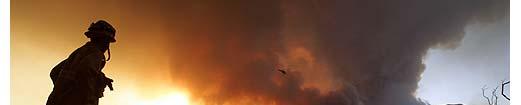
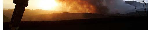
14 Emergency management Recent fires in Santa Barbara Zaca Fire (July 07) burned for 2 months no houses lost Gap Fire (July 08) burned for 7 days no houses lost Tea Fire (November 08) burned for 2 days 230 houses lost Jesusita Fire (May 09) burned for 2 days 75 houses lost
15
16
17
18 Hits Source Jesusita Fire (Ethan) SBC Jesusita Fire Santa Barbara, CA (Robert O'Connor - fire news blog) Jesusita Fire Map (Randy - Independent.com) Jesusita Fire in Santa Barbara - LA Times map (Los Angeles Times) Map of burned homes in Santa Barbara (Los Angeles Times) Jesusita Fire Evacuation Areas: Approximation (COSB) Santa Barbara 'Jesusita Fire' (ABC7 Eyewitness News) Jesusita Fire - Santa Barbara (lanewspace) 2446 Santa Barbara Damaged Homes 2008 (Los Angeles Times, note: mapped for comparison with Jesusita) 2048 Jesusita Fire (longhairedhippy) 1314 Santa Barbara Fire Evacuation (Gary); 962 Jesusita Fire in Santa Barbara (ABC30 Action News) 788 Wildfire ~ Santa Barbara (Buffalo) 505 Closure map - Jesusita Fire in Santa Barbara (Los Angeles Times) 461 Untitled (Matthew, note: discovered via google.com.mx); 396 Jesusita Fire Structure Damage (Paul Bartsch); 18
19 Lessons learned Authoritative ti information must be verified by officials too slow for the Tea and Jesusita Fires Asserted information carries risk of false positives false rumor of Tea Fire in Mission i Canyon some unnecessary evacuations people are willing to accept false positives lack of authoritative information amounts to false negatives false negatives are far less acceptable than false positives there were some posted false negatives


20 LA Times May
21 Critical spatial thinking Larger than GIS now that the technology is easier to use What every Google Earth user needs to know Focus on fundamental spatial concepts from simple, acquired in early childhood to advanced, acquired in college One of Gardner s seven types of intelligence almost entirely neglected in education
22 1. Linguistic Children with this kind of intelligence enjoy writing, reading, telling stories or doing crossword puzzles. 2. Logical-Mathematical Children with lots of logical intelligence are interested in patterns, categories and relationships. They are drawn to arithmetic problems, strategy games and experiments. 3. Bodily-Kinesthetic These kids process knowledge through bodily sensations. They are often athletic, dancers or good at crafts such as sewing or woodworking. 4. Spatial These children think in images and pictures. They may be fascinated with mazes or jigsaw puzzles, or spend free time drawing, building with Lego or daydreaming. 5. Musical Musical children are always singing or drumming to themselves. They are usually quite aware of sounds others may miss. These kids are often discriminating listeners. 6. Interpersonal Children who are leaders among their peers, who are good at communicating and who seem to understand others' feelings and motives possess interpersonal intelligence. 7. Intrapersonal These children may be shy. They are very aware of their own feelings and are selfmotivated. Howard Gardner


23 What is spatial thinking? Three aspects of spatial ability: Spatial knowledge symmetry, orientation, scale, distance decay, etc. Spatial ways of thinking and acting using diagramming or graphing, recognizing patterns in data, change over space from change over time, etc. Spatial capabilities ability to use tools and technologies such as spreadsheet, graphical, statistical, and GIS software to analyze spatial data
24 Developing intelligences Mathematical, verbal, musical attention throughout K-16 Spatial IQ tests trivia questions Which is further west, San Diego or Reno?
25 What fundamental concepts exist in spatial intelligence? Are they sophisticated and abstract enough to warrant a place in the curriculum? like mathematics, statistics, language, g music can spatial intelligence gain more respect? where in the curriculum? Are they an appropriate basis for improved GIS user interface design? does the interface need improvement?
26 A complex set of tools A GIS is capable of virtually any conceivable operation on spatial data how many conceivable operations are there? ArcGIS toolkit 542 operations 18 headings, up to 4 levels l of hierarchical organization headings include: Analysis, Spatial Analyst, 3D Analyst, Geostatistical Analyst, Spatial Statistics Data Management, Conversion
27 1. Location Defining i and measuring location the impossibility of exact measurement From infinitesimal point to extended area Place how many places are there in the U.S.? Location as context Location as common key It is important t to know where events occur

 in New Orleans,")


28 Cyberscape: Placemarks in post-katrina New Orleans Flooding Reports (via Scipionus) in New Orleans, Sept Who was able to or interested in using this new technology? Which places were they interested in? Crutcher and Zook GeoForum
29 Jesus and Allah BLUE = (more Jesus than Allah); RED = (more Allah than Jesus). Size of the bubble show the magnitude of the difference
30 2. Distance, direction Measurement plane, globe buffers Distance decay decline of interaction with distance cost, time impediments footprints of human behavior

31
32
33 3. Neighborhood/region/territory The context of individuals action space Homogeneous areas The reporting zone containing the individual arbitrarily imposed on a continuous Earth The ecological fallacy the modifiable areal unit problem Competition for space trade areas, bird territories functional regions
34
35
36 Level of detail 4. Scale the inevitability of generalization Extent generalizability of results Methods of upscaling, downscaling Fractal concepts Scale is always important many properties cannot be defined d independently d of scale length of a coastline slope of a topographic surface land use class the flattest spot in the US
37 Conclusions Web 2.0 is creating novel sources of geospatial information that can complement traditional sources that can play a key role in time-critical situations It is possible to enumerate the fundamental concepts of a spatial approach four broadly defined concepts 27 in De Smith, Goodchild, and Longley (2006) Geospatial Analysis in ontology
38 Karl Grossner
39
40 Conclusions (2) Critical spatial thinking is more than GIS an enveloping conceptual framework for many new technologies and disciplines phenomena embedded in space and time many drivers One of a minimal set of intelligences part of everyone s education
Michael F. Goodchild University of California Santa Barbara
 The Changing Face of GIS Michael F. Goodchild University of California Santa Barbara 1 Two topics New data sources Critical spatial thinking 2 How is geographic information created? By authorities and
Fundamental Spatial Concepts. Michael F. Goodchild University of California Santa Barbara
 Fundamental Spatial Concepts Michael F. Goodchild University of California Santa Barbara A spatial turn in science Adding space to theory the New Economic Geography space impeding flows of information,
The Future of Geography in an. Society. Michael F. Goodchild University of California Santa Barbara
 The Future of Geography in an Emerging Information-Technology Society Michael F. Goodchild University of California Santa Barbara Geographic technologies Positioning i on the Earth s surface GPS, RFID
Michael F. Goodchild University of California Santa Barbara
 Challenges in GIS Research Michael F. Goodchild University of California Santa Barbara Thanks to Ordnance Survey of GB SPLINT Leicester, Nottingham, UCL Organizers GIS research Since 1960s Changing agenda
California Reality and Nova Scotia Dreaming. Michael F. Goodchild University of California Santa Barbara
 California Reality and Nova Scotia Dreaming Michael F. Goodchild University of California Santa Barbara 1 The geospatial world Remote sensing Geographic information systems Automated cartography Global
A spatial literacy initiative for undergraduate education at UCSB
 A spatial literacy initiative for undergraduate education at UCSB Mike Goodchild & Don Janelle Department of Geography / spatial@ucsb University of California, Santa Barbara ThinkSpatial Brown bag forum
Citizens as Sensors: The World of Volunteered Geography. Michael F. Goodchild University of California Santa Barbara
 Citizens as Sensors: The World of Volunteered Geography Michael F. Goodchild University of California Santa Barbara VGI examples research hissues Case study Outline VGI in emergency management Individual
Citizens as Sensors: Web 2.0 and the World of Volunteered Geography. Michael F. Goodchild University of California Santa Barbara
 Citizens as Sensors: Web 2.0 and the World of Volunteered Geography Michael F. Goodchild University of California Santa Barbara How is geographic information created? By authorities USGS NGA Ordnance Survey
GIScience: Current Technology. Michael F. Goodchild University of California Santa Barbara
 GIScience: Current Technology Michael F. Goodchild University of California Santa Barbara What is a GIS? A class of software designed to handle geographic information and perform virtually any conceivable
Geographic Information Systems and Science: Today and Tomorrow. Michael F. Goodchild University of California Santa Barbara
 Geographic Information Systems and Science: Today and Tomorrow Michael F. Goodchild University of California Santa Barbara Geospatial technologies Positioning on the Earth s surface GPS, RFID Acquisition
Towards data driven decision-making using crowd-sourced geographic information. Linna Li University of Redlands December 2, 2015
 Towards data driven decision-making using crowd-sourced geographic information Linna Li (linna.li@csulb.edu) University of Redlands December 2, 2015 WalMap: Walgreens store location map Geographic information
Vision 2020: Focus on the Future. Michael F. Goodchild University of California Santa Barbara
 Vision 2020: Focus on the Future Michael F. Goodchild University of California Santa Barbara A little context Gore, Earth in the Balance, 1992 a single portal to Earth information Fall 1997 Tom Kalil,
Twenty Years of Progress: GIScience in Michael F. Goodchild University of California Santa Barbara
 Twenty Years of Progress: GIScience in 2010 Michael F. Goodchild University of California Santa Barbara Outline The beginnings: GIScience in 1990 Major accomplishments research institutional The future
CyberGIS: What Still Needs to Be Done? Michael F. Goodchild University of California Santa Barbara
 CyberGIS: What Still Needs to Be Done? Michael F. Goodchild University of California Santa Barbara Progress to date Interoperable location referencing coordinate transformations geocoding addresses point-of-interest
Hurricanes A 5 Day Unit Plan. Kristy Scott EDUC 651 October 30, nd grade
 Hurricanes A 5 Day Unit Plan Kristy Scott EDUC 651 October 30, 2006 2 nd grade Unit Overview Unit Description: The focus of this unit is to combine the students experiences of Hurricane Katrina with the
Esri and GIS Education
 Esri and GIS Education Organizations Esri Users 1,200 National Government Agencies 11,500 States & Regional Agencies 30,800 Cities & Local Governments 32,000 Businesses 8,500 Utilities 12,600 NGOs 11,000
Spatial Analysis and Modeling (GIST 4302/5302) Guofeng Cao Department of Geosciences Texas Tech University
 Guofeng Cao Department of Geosciences Texas Tech University") Spatial Analysis and Modeling (GIST 4302/5302) Guofeng Cao Department of Geosciences Texas Tech University TTU Graduate Certificate Geographic Information Science and Technology (GIST) 3 Core Courses and
Spatial Analysis and Modeling (GIST 4302/5302) Guofeng Cao Department of Geosciences Texas Tech University TTU Graduate Certificate Geographic Information Science and Technology (GIST) 3 Core Courses and
30 YEARS SINCE Z_GIS FOUNDING: PROVIDING SOLUTIONS FOR SOCIETY AND BUSINESS
 30 YEARS SINCE Z_GIS FOUNDING: PROVIDING SOLUTIONS FOR SOCIETY AND BUSINESS Michael F Goodchild Emeritus Professor of Geography University of California, Santa Barbara Keynote GIScience Symposium, Salzburg,
Citizen Science at the. U.S. Geological Survey
 Citizen Science at the U.S. Geological Survey David Applegate USGS Associate Director for Natural Hazards NRC Board on Earth Science & Resources December 5, 2014 U.S. Department of the Interior U.S. Geological
Your web browser (Safari 7) is out of date. For more security, comfort and. the best experience on this site: Update your browser Ignore
 is out of date. For more security, comfort and. the best experience on this site: Update your browser Ignore") Your web browser (Safari 7) is out of date. For more security, comfort and lesson the best experience on this site: Update your browser Ignore Political Borders Why are the borders of countries located
Your web browser (Safari 7) is out of date. For more security, comfort and lesson the best experience on this site: Update your browser Ignore Political Borders Why are the borders of countries located
Science in the News - Plate Tectonics 1. Story
 Science in the News - Plate Tectonics 1. Story Scientists who study the Earth tell us the continents and ocean floors are always moving. This movement sometimes can be violent, causing death and destruction.
Lesson Plan Bond Prediction Tenth Grade Chemistry By Rich Wilczewski
 Lesson Plan Bond Prediction Tenth Grade Chemistry By Rich Wilczewski LEARNING OUTCOMES: Students will use their textbook outlines to define the following: Chemical Bond, Covalent Bond, Ionic Bond and Polar
A To Z GIS: An Illustrated Dictionary Of Geographic Information Systems PDF
 A To Z GIS: An Illustrated Dictionary Of Geographic Information Systems PDF An invaluable resource for anyone who uses or encounters GIS terminology in the classroom, on the job, or in the field, this
A General Framework for Conflation
 A General Framework for Conflation Benjamin Adams, Linna Li, Martin Raubal, Michael F. Goodchild University of California, Santa Barbara, CA, USA Email: badams@cs.ucsb.edu, linna@geog.ucsb.edu, raubal@geog.ucsb.edu,
Identifying Wildfire Risk Areas in Western Washington State
 Identifying Wildfire Risk Areas in Western Washington State Matthew Seto University of Washington Tacoma GIS Certification Program URISA 2015 Undergraduate Geospatial Skills Competition Introduction 2014
St John s Catholic Primary School. Geography Policy. Mission Statement
 St John s Catholic Primary School Geography Policy Mission Statement We at St John s strive for excellence in education by providing a safe, secure and caring family environment where individuals are valued
The Case for Space in the Social Sciences
 The Case for Space in the Social Sciences Don Janelle Center for Spatially Integrated Social Science University of California, Santa Barbara Roundtable on Geographical Voices and Geographical Analysis
Chapter 1 Introduction
 1 Chapter 1 Introduction Figure 1.1: Westlake Plaza A warm sunny day on a downtown street and plaza, pedestrians pass on the sidewalks, people sit on benches and steps, enjoying a cup of coffee, shoppers
8/28/2011. Contents. Lecture 1: Introduction to GIS. Dr. Bo Wu Learning Outcomes. Map A Geographic Language.
 Contents Lecture 1: Introduction to GIS Dr. Bo Wu lsbowu@polyu.edu.hk Department of Land Surveying & Geo-Informatics The Hong Kong Polytechnic University 1. Learning outcomes 2. GIS definition 3. GIS examples
St. Helens: Out of the Ash Learning Resource Guide
 St. Helens: Out of the Ash Learning Resource Guide Overview: In May of 1980 Mount St. Helens grabbed the world s attention by putting on a volcanic display never before witnessed in modern times. Today,
Reimaging GIS: Geographic Information Society. Clint Brown Linda Beale Mark Harrower Esri
 Reimaging GIS: Geographic Information Society Clint Brown Linda Beale Mark Harrower Esri 8 billion = Number of basemap requests per month on AGOL 14,000 = Unique requests per second 12,000 = New Items
From VOA Learning English, this is SCIENCE IN THE NEWS, in Special English. I m Kelly Jean Kelly.
 From VOA Learning English, this is SCIENCE IN THE NEWS, in Special English. I m Kelly Jean Kelly. And I m Christopher Cruise. Scientists who study the Earth tell us the continents and ocean floors are
Working with ArcGIS Online
 Esri International User Conference San Diego, CA Technical Workshops July 12, 2011 Working with ArcGIS Online Bern Szukalski, Deane Kensok Topics for this Session ArcGIS Online Overview ArcGIS Online Content
North Carolina Essential Standards Kindergarten Social Studies
 North Carolina s Kindergarten Social Studies Kindergarten through second grade students are introduced to an integrative approach of Social Studies by exploring aspects of self, others, families and communities
Hurricane Katrina kills hundreds
 www.breaking News English.com Ready-to-use ESL / EFL Lessons Hurricane Katrina kills hundreds URL: http://www.breakingnewsenglish.com/0508/050831-katrina-e.html Today s contents The Article 2 Warm-ups
Motivating Questions: How many hurricanes happen in a year? Have the number of hurricanes per year changed over time?
 Hurricanes Over Time Materials For the leader: Projector Whiteboard to project data graph onto For the activity: Graphing paper Markers Globe Copy of data cards Overview Hurricanes occur in the North Atlantic
GIS Applications on Environmental Education in Taiwan
 GIS Applications on Environmental Education in Taiwan Track: Education Authors: Yu-Chen Lai, Mei-Ling Yeh, Tien-Yin Chou Abstract GIS is a perfect vehicle to deliver environmental knowledge and spatial
Mapping Religious Cyberscapes:
 Mapping Religious Cyberscapes: Google and User Generated Religion Dr. Matthew Zook Department of Geography University of Kentucky New Technologies and Interdisciplinary Research on Religion, Harvard University
Welcome. C o n n e c t i n g
 Welcome C o n n e c t i n g YOU D i s c i p l i n e s Why is This Meeting......So Important Now? OUR WORLD Is Increasingly Challenged The Evidence Is Clear We Need Better Understanding and More Collaboration
History EC LE UE MS. Knows the names and order of the Seasons of the Year and science behind it
 History EC LE UE MS Time and Timelines : awareness of how the universe and life came to be and his/her place on the continuum. The child discovers interests, makes connections and draws inferences about
Lesson 10: Comparing Functions and their features
 Lesson 10: Comparing Functions and their features Standards: MAFS.912.F-IF.2.4 For a function that models a relationship between two quantities, interpret key features of graphs and tables in terms of
Abbotswood Junior School National Curriculum 2014
 Geography Purpose A high-quality geography education should inspire in pupils a curiosity and fascination about the world and its people that will remain with them for the rest of their lives. Teaching
netw rks Guided Reading Activity Essential Question: How does geography influence the way people live? What Is Geography?
 Guided Reading Activity What Is Geography? Lesson 1 Thinking Like a Geographer Essential Question: How does geography influence the way people live? Directions: Read the lesson and use your textbook to
You are Building Your Organization s Geographic Knowledge
 You are Building Your Organization s Geographic Knowledge And Increasingly Making it Available Sharing Data Publishing Maps and Geo-Apps Developing Collaborative Approaches Citizens Knowledge Workers Analysts
St Joseph s R.C. Primary School. Policy for Geography
 St Joseph s R.C. Primary School Policy for Geography 2016-2017 This policy is written with consideration to our school commitment to the Rights of the Child and our achievement of becoming a Rights Respecting
Curriculum Pacing Guide-Kindergarten History and Science Based on Virginia Standards of Learning for History Adopted 2015
 1 Time frame Unit/SOL SOL Notes September September Social Studies- Citizenship/ Civics The student will demonstrate that being a good citizen involves a) taking turns and sharing; b) taking responsibility
Willmar Public Schools Curriculum Map
 Subject Area Grade First Grade Date June 2005, reviewed June 2009 Unit Content Standards Addressed Skills/Benchmarks Essential Questions Assessments Unit 1 Here We Are and Our Class Our School Our Families
Geography and Usability of the American Community Survey. Seth Spielman Assistant Professor of Geography University of Colorado
 Geography and Usability of the American Community Survey Seth Spielman Assistant Professor of Geography University of Colorado Goals 1. To convince you that the margins of error from the American Community
Spatial Pattern Analysis: Mapping Trends and Clusters
 2013 Esri International User Conference July 8 12, 2013 San Diego, California Technical Workshop Spatial Pattern Analysis: Mapping Trends and Clusters Lauren Rosenshein Bennett Brett Rose Presentation
Earthquakes in Ohio? Teacher Directions and Lesson
 Earthquakes in Ohio? Teacher Directions and Lesson If I say, earthquake what state do you think of? Answers will vary, but California is a likely answer. What if I asked you, Where could you live in the
A Framework for Implementing Volunteered Geographic Information Systems
 A Framework for Implementing Volunteered Geographic Information Systems Claus Rinner, Victoria Fast Department of Geography, Ryerson University, Toronto, ON; crinner@ryerson.ca Abstract In an effort to
GEOGRAPHY POLICY STATEMENT. The study of geography helps our pupils to make sense of the world around them.
 GEOGRAPHY POLICY STATEMENT We believe that the study of geography is concerned with people, place, space and the environment and explores the relationships between the earth and its peoples. The study
file://q:\report1\greenatlasfinalreportindex.html
 Page 1 of 8 Quick Links WATER MANAGEMENT INTERNSHIP USDA HIS GRANT FUNDED FINAL PROJECT REPORT SUBMITTED BY MELISSA QUINTANA 11/07/07-03/24/08 Summary Provided is an assessment of my accomplishments for
Your web browser (Safari 7) is out of date. For more security, comfort and the best experience on this site: Update your browser Ignore
 is out of date. For more security, comfort and the best experience on this site: Update your browser Ignore") Your web browser (Safari 7) is out of date. For more security, comfort and the best experience on this site: Update your browser Ignore Activitydevelop Educator Version INTRO DUCTIO N TO L ATITU DE AND
Your web browser (Safari 7) is out of date. For more security, comfort and the best experience on this site: Update your browser Ignore Activitydevelop Educator Version INTRO DUCTIO N TO L ATITU DE AND
Smart Citizens. Maria Antonia Brovelli Politecnico di Milano, Italy
 Smart Citizens Maria Antonia Brovelli Politecnico di Milano, Italy UN-GGIM Academic Network Forum Secure Land Rights and Smart Cities: Making It Work for Sustainable Development New York, 31 July 2017
CSISS Resources for Research and Teaching
 CSISS Resources for Research and Teaching Donald G. Janelle Center for Spatially Integrated Social Science University of California, Santa Barbara Montreal 26 July 2003 Workshop on Spatial Analysis for
Unlocking the Power of Geographic Inquiry. Thomas Herman, PhD Director, California Geographic Alliance Department of Geography, San Diego State Univ.
 Unlocking the Power of Geographic Inquiry Thomas Herman, PhD Director, California Geographic Alliance Department of Geography, San Diego State Univ. Why I am here, and how I got here A few words about
Geography Policy. for Hertsmere Jewish Primary School
 Geography Policy for Hertsmere Jewish Primary School Reviewed by: L Rubin Reviewed on: September 2017 Date of Next Review: September 2018 Policy Review This policy will be reviewed in full by the Governing
Application Issues in GIS: the UCL Centre for Advanced Spatial Analysis. Paul Longley UCL
 Application Issues in GIS: the UCL Centre for Advanced Spatial Analysis Paul Longley UCL GIS: inclusive, shared understanding Geodemographics as a focus of interest Profiling public goods and services
2018 NASCIO Award Submission Category: Cross-Boundary Collaboration and Partnerships. Project Title: Tennessee Wildfires: A Coordinated GIS Response
 2018 NASCIO Award Submission Category: Cross-Boundary Collaboration and Partnerships Project Title: Tennessee Wildfires: A Coordinated GIS Response Sevier County, Tennessee State of Tennessee, Emergency
GIS CONCEPTS Part I. GIS ON THE WEB Part II
 Week 2 GIS CONCEPTS Part I GIS ON THE WEB Part II topics of the week part I GIS functions and GIS data Spatial relationships Organizing convention for spatial data Store Information by thematic layers
Walworth Primary School
 Walworth Primary School Date: April 2016 Revision Due: April 2017 Ref: L.Smith Geography Policy 1 Geography Policy Introduction A high quality geography education should inspire in pupils a curiosity and
Discovering Spatial Thinking
 Discovering Spatial Thinking Arnold Bregt UCSB, 5 October 2010 Experiment Contents Part 1: My discovery of Spatial Thinking Literature Framework for Spatial Thinking UCSB Questionnaire Part 2: Some projects
An Introduction to Scientific Research Methods in Geography Chapter 3 Data Collection in Geography
 An Introduction to Scientific Research Methods in Geography Chapter 3 Data Collection in Geography Learning Objectives What is the distinction between primary and secondary data sources? What are the five
Introducing GIS analysis
 1 Introducing GIS analysis GIS analysis lets you see patterns and relationships in your geographic data. The results of your analysis will give you insight into a place, help you focus your actions, or
Hazmat event reporting in the media
 Hazmat event reporting in the media Ralph Stuart, CIH, CCHO Chemical Hygiene Officer, Keene State College Secretary, Division of Chemical Health and Safety, American Chemical Society August, 2017 The Project
True Halloween 2. True Halloween 2
 We have made it easy for you to find a PDF Ebooks without any digging. And by having access to our ebooks online or by storing it on your computer, you have convenient answers with true halloween 2. To
Medical GIS: New Uses of Mapping Technology in Public Health. Peter Hayward, PhD Department of Geography SUNY College at Oneonta
 Medical GIS: New Uses of Mapping Technology in Public Health Peter Hayward, PhD Department of Geography SUNY College at Oneonta Invited research seminar presentation at Bassett Healthcare. Cooperstown,
Smart use of Geographic Information System (GIS) platform for delivering weather information and nowcasting services
 platform for delivering weather information and nowcasting services") Smart use of Geographic Information System (GIS) platform for delivering weather information and nowcasting services C. K. Pan Hong Kong Observatory Hong Kong, China It is a world of beauty Source: Image
Smart use of Geographic Information System (GIS) platform for delivering weather information and nowcasting services C. K. Pan Hong Kong Observatory Hong Kong, China It is a world of beauty Source: Image
The Importance of Spatial Literacy
 The Importance of Spatial Literacy Dr. Michael Phoenix GIS Education Consultant Taiwan, 2009 What is Spatial Literacy? Spatial Literacy is the ability to be able to include the spatial dimension in our
Rural GIS Applications Geospatial Technology Awareness
 Rural GIS Applications Geospatial Technology Awareness Mike Rudibaugh, Ph.D. Co-PI NSF GeoTech Center Geography/GIS Instructor Lake Land College mrudibau@lakeland.cc.il.us 217-234-5244 What is the GeoTech
WEEK 1 THE BIBLE BIG IDEA WELCOME TIME DISCUSSION TIME TEACHING TIME PLAY TIME PRESCHOOL LESSON OUTLINE THIS WEEK AT A GLANCE
 WEEK 1 PRESCHOOL LESSON OUTLINE BIG IDEA Jesus cares about us when we are sick. THE BIBLE Jesus Heals the Leper: Luke 5:12-15 THIS WEEK AT A GLANCE WELCOME TIME ACTIVITY Play-Doh Unbelievable Scenes ACTIVITY
National Geographic Geography Bee Study Guide
 We have made it easy for you to find a PDF Ebooks without any digging. And by having access to our ebooks online or by storing it on your computer, you have convenient answers with national geographic
Lesson 39. The Vine and the Branches. John 15:1-8
 L i f e o f C h r i s t from the gospel of J o h n Lesson 39 The Vine and the Branches John 15:1-8 Mission Arlington Mission Metroplex Curriculum 2010 Created for use with young, unchurched learners Adaptable
Module 2 Educator s Guide Investigation 2
 Module 2 Educator s Guide Investigation 2 How does remote sensing help us to observe human activities on Earth? Investigation Overview Landscapes that are influenced by human activities are found nearly
Subject: Geography Scheme of Work: B1 to B6 Mastery tiles. Term: Autumn/Spring/Summer
 Subject: Geography Scheme of Work: B1 to B6 Mastery tiles Term: Autumn/Spring/Summer Topic / Unit(s) Overview / Context Introduction to geography. An introduction to geography including basic map skills
Improving Spatial Data Interoperability
 Improving Spatial Data Interoperability A Framework for Geostatistical Support-To To-Support Interpolation Michael F. Goodchild, Phaedon C. Kyriakidis, Philipp Schneider, Matt Rice, Qingfeng Guan, Jordan
Geography Policy 2014
 Geography Policy 2014 DEFINITION Geography education should inspire in pupils a curiosity and fascination about the world and its people that will remain with them for the rest of their lives. Teaching
Geospatial Tactical Decision Aids
 Geospatial Tactical Decision Aids Miguel Pacheco Abstract Environmental conditions are known to affect the efficiency and effectiveness of military platforms, weapon systems and personnel. The translation
Application of WebGIS and VGI for Community Based Resources Inventory. Jihn-Fa Jan Department of Land Economics National Chengchi University
 Application of WebGIS and VGI for Community Based Resources Inventory Jihn-Fa Jan Department of Land Economics National Chengchi University OUTLINE Introduction Methodology Results Conclusions 2 MOTIVATION
THE WASHINGTON COASTAL ATLAS
 THE ICAN COASTAL ATLAS MEDIATOR PROTOTYPE AND CONNECTING THE WASHINGTON COASTAL ATLAS Liz O Dea 1, Yassine Lassoued 2, Tanya Haddad 3, Declan Dunne 2 1 GIS Services Unit, WA State Dept. of Ecology 2 Coastal
locate the world s countries, using maps to focus on Europe (including the location of
 Year 3 and 4 Geography study- Autumn 2 2017 National curriculum: Locational knowledge locate the world s countries, using maps to focus on Europe (including the location of Russia) and North and South
Why write proofs? Why not just test and repeat enough examples to confirm a theory?
 P R E F A C E T O T H E S T U D E N T Welcome to the study of mathematical reasoning. The authors know that many students approach this material with some apprehension and uncertainty. Some students feel
Unit 1, Lesson 3 What Tools and Technologies Do Geographers Use?
 Unit 1, Lesson 3 What Tools and Technologies Do Geographers Use? Geographers use a variety of tools and technologies in investigating geographic questions. Maps and globes both represent the earth, but
MEADOWS PRIMARY SCHOOL and NURSERY GEOGRAPHY POLICY
 MEADOWS PRIMARY SCHOOL and NURSERY GEOGRAPHY POLICY Purpose of study The teaching of Geography at Meadows is done by following the 2014 National Curriculum. The planning and teaching of the subject aims
Use maps, atlases, globes and computer mapping to locate countries and describe features studied
 Roseberry Primary School Curriculum planning Lead Question: What s so amazing about America? National Curriculum driver: Geography Rationale statement: In this study about the amazing Americas, children
STAG LANE JUNIOR SCHOOL GEOGRAPHY POLICY
 Status-Recommended Prepared by: Megha Visavadia Date written January 2017 Shared with staff: Spring 2017 STAG LANE JUNIOR SCHOOL GEOGRAPHY POLICY Shared with governors: Spring 2018 Date for review: July
Relations and Functions
 Algebra 1, Quarter 2, Unit 2.1 Relations and Functions Overview Number of instructional days: 10 (2 assessments) (1 day = 45 60 minutes) Content to be learned Demonstrate conceptual understanding of linear
Your web browser (Safari 7) is out of date. For more security, comfort and. the best experience on this site: Update your browser Ignore
 is out of date. For more security, comfort and. the best experience on this site: Update your browser Ignore") Your web browser (Safari 7) is out of date. For more security, comfort and Activitydevelop the best experience on this site: Update your browser Ignore Places in the Park Why do we use symbols? Overview
Your web browser (Safari 7) is out of date. For more security, comfort and Activitydevelop the best experience on this site: Update your browser Ignore Places in the Park Why do we use symbols? Overview
GENERAL. CHAPTER 1 BACKGROUND AND PURPOSE OF THE GUIDELINES Background of the Guidelines Purpose of the Guidelines...
 GENERAL CHAPTER 1 BACKGROUND AND PURPOSE OF THE GUIDELINES... 1 1.1 Background of the Guidelines... 1 1.2 Purpose of the Guidelines... 3 CHAPTER 2 APPLICATION OF THE GUIDELINES... 3 2.1 Potential Users
Download PDF Syllabus of Class 10th CBSE Mathematics Academic year
 Download PDF Syllabus of Class 10th CBSE Mathematics Academic year 2018-2019 Download PDF Syllabus of Class 11th CBSE Mathematics Academic year 2018-2019 The Syllabus in the subject of Mathematics has
GIS Institute Center for Geographic Analysis
 GIS Institute Center for Geographic Analysis Welcome Intensive training in the application of GIS to research Collection, management, analysis, and communication of spatial data Topics include: data collection,
ENV208/ENV508 Applied GIS. Week 1: What is GIS?
 ENV208/ENV508 Applied GIS Week 1: What is GIS? 1 WHAT IS GIS? A GIS integrates hardware, software, and data for capturing, managing, analyzing, and displaying all forms of geographically referenced information.
Powerful Combination: GIS and Web Services
 IEEE DISTRIBUTED SYSTEMS ONLINE 1541-4922 2004 Published by the IEEE Computer Society Vol. 5, No. 2; February 2004 Powerful Combination: GIS and Web Services Adam Stone At the University of North Texas's
Jim Fox. copyright UNC Asheville's NEMAC
 Decisions and System Thinking Jim Fox November, 2012 1 UNC Asheville s s NEMAC National Environmental Modeling and Analysis Center Applied Research and technology development on integration of environmental
Taxonomies of Building Objects towards Topographic and Thematic Geo-Ontologies
 Taxonomies of Building Objects towards Topographic and Thematic Geo-Ontologies Melih Basaraner Division of Cartography, Department of Geomatic Engineering, Yildiz Technical University (YTU), Istanbul Turkey
SCOPE & SEQUENCE. Algebra I
 Year at a Glance August September October November December January February March April May 1. Functions, 4.Systems Expressions, 2. Polynomials and 6. Exponential STAAR SLA 3. Linear Functions of Break
ST AMBROSE CATHOLIC PRIMARY SCHOOL Geography Policy
 ST AMBROSE CATHOLIC PRIMARY SCHOOL Geography Policy 2017-2018 Our school policy is developed in accordance with the National Curriculum for Geography and Foundation Stage Curriculum for Understanding of
Preparing for Eruptions What will happen in future eruptions and how can we be prepared?
 Lesson Plan 12 Activities 1. Read or listen to Matt s Volcano Story from What s the Plan Stan Stories on: http://www.whatstheplanstan.govt.nz/teacher.html#disasters Discuss what Matt saw and did before,
Hurricane Dennis menaces U.S. coast
 www.breaking News English.com Ready-to-use ESL / EFL Lessons Hurricane Dennis menaces U.S. coast URL: http://www.breakingnewsenglish.com/0507/050711-dennis-e.html Today s contents The Article 2 Warm-ups