Towards data driven decision-making using crowd-sourced geographic information. Linna Li University of Redlands December 2, 2015
|
|
|
- Francine Gray
- 6 years ago
- Views:
Transcription

1 Towards data driven decision-making using crowd-sourced geographic information Linna Li University of Redlands December 2, 2015


2 WalMap: Walgreens store location map
3 Geographic information information about specific characteristics of places on or near the Earth s surface <x, z> where x is a location in space-time, z is a set of general properties associated with x information about pairs of locations <x 1,x 2,z> where z is distance, interaction, travel cost, travel time, connectivity, direction, etc.


4 Traditional sources of geographic data By authorities and their experts USGS U.S. Census Bureau TIGER files (Topologically Integrated Geographic Encoding and Referencing) NGA military in many countries state and local governments data companies, e.g. street networks, business locations

5 Geospatial technologies Positioning on the Earth s surface GPS, RFID Acquisition systems remote sensing field measurement Web GIS and mapping Google Maps, Google Earth OpenStreetMap Business locations in Google Maps
6 New sources of geographical data Volunteered geographic information (VGI; Goodchild 2007) a phenomenon of the 21 st Century user-generated content asserted information the empowerment of millions of private citizens largely untrained no obvious reward no guarantee of truth no authority Spatio-temporal footprints generated by social media Twitter, Flickr, etc.

7 Big data Big data: s, blogs, photos, videos, geographic datasets Widely disseminated over the Internet: Twitter, Flickr, Youtube, Openstreetmap 92% of babies in the US have online presence before two years old (AVG).

8
9 OpenStreetMap vs. Google Maps
10 Geographic data from online communities Twitter: a social networking site Flickr: online photo management service Georeferenced tweet messages in Twitter and georeferenced photos in Flickr


11 Tweets and photo metadata in the database January 23rd to February 12th, 2011, more than 4 million tweets January, 1st to February, 25th, 2011, about 800,000 photos
12 Georeferenced tweets within three weeks

13 A close-up of the georeferenced tweets in Los Angeles county
14 Number of georeferenced tweets generated by the top 1000 users

15 Yosemite Denver Charleston (Li, Goodchild, Xu, 2013)
16 Temporal variation of tweets
17 Place and footprints Place Fundamental concept in everyday life. Place names are omnipresent in conversations, documents, and news stories. Place referencing : meeting locations (e.g., University of Redlands), navigation (e.g., from CSULB to University of Redlands), trip planning Footprints Traces of people interacting with their surroundings Coordinates: latitude, longitude
18 A location on the Earth s surface Two ways: Place names: adopted by human beings Coordinates: adopted by computers Defining places from footprints: What are the significant places that are identified in space? Where are they?
19 Location, place, gazetteers Location is a key concept in everyday life. Coordinates Point, polyline, polygon One universal spatial coordinate system: latitude, longitude Place names Easier to comprehend and remember Frequently used in human discourse Place denotes the significance of a location Gazetteer: a bridge between place names and spatial coordinates Three core elements in a gazetteer: place name, place type, and spatial location E.g., GeoNames
20 Representation of vague places Participants identify and draw downtown Santa Barbara (Montello et al., 2003) User needs for place data based on an empirical study, as well as the implications for modeling place in GIS (Davies et al., 2009) The use of place names harvested from the Web to find the spatial extents of vague places (Jones et al., 2008) The use of geotags to build bottom-up gazetteers and compared extracted place location with the location in a gazetteer (Keßler et al., 2009)
21 Data Footprints associated with photos in Flickr Collected photo metadata using the Flickr public API. Approximately 150,000 photographs georeferenced within the bounding box of the Île-de-France region. Metadata include photo ID, title, description, tags, time when a photo was taken and uploaded, latitude and longitude, as well as information about the user who uploaded the picture.
22 Preprocessing Flickr data are a type of VGI, so they lack mechanism for quality control. Variations of place names are present. Eiffel Tower: eiffeltower, eiffel, theeiffeltower, towereiffel, eifeltower, toureiffel, torreeiffel, latoureiffel, paristorreeiffel, toureiffelparis, eiffeltoren, eiffelturm, eiffeltã, eiffeltour, eifelturm, eifel, toureifel, and torreeifell. Errors are present in location Users mass upload to the same point location with the same group of tags a set of pictures that were taken during a trip that involves several places. In such as case, only one photograph is retained.
23 Spatial extent of place Places under study: Paris, Eiffel Tower, Louvre, Montmartre, Notre Dame, Palace of Versailles, and Disneyland. Method: kernel density estimation The kernel estimator where n is the number of points, h is the bandwidth that determines the amount of smoothing, K is the kernel function, x is the location to be estimated, and x i is a point location.

24 Footprints of photographs with the geotag "Paris" over the administrative boundaries of France The spatial extent of Paris generated from geotagged photos

25 Notre Dame Uncertainty: 78,200m Montmartre Uncertainty: 9,600m

26 Palace of Versailles Eiffel Tower
27 Relation between places Relationships between a larger place and smaller places that compose the larger place can also be inferred from spatial footprints. Constituent places are not exclusive of each other. They also do not cover all locations in a larger place. Smaller places are distributed over different parts of a larger place.

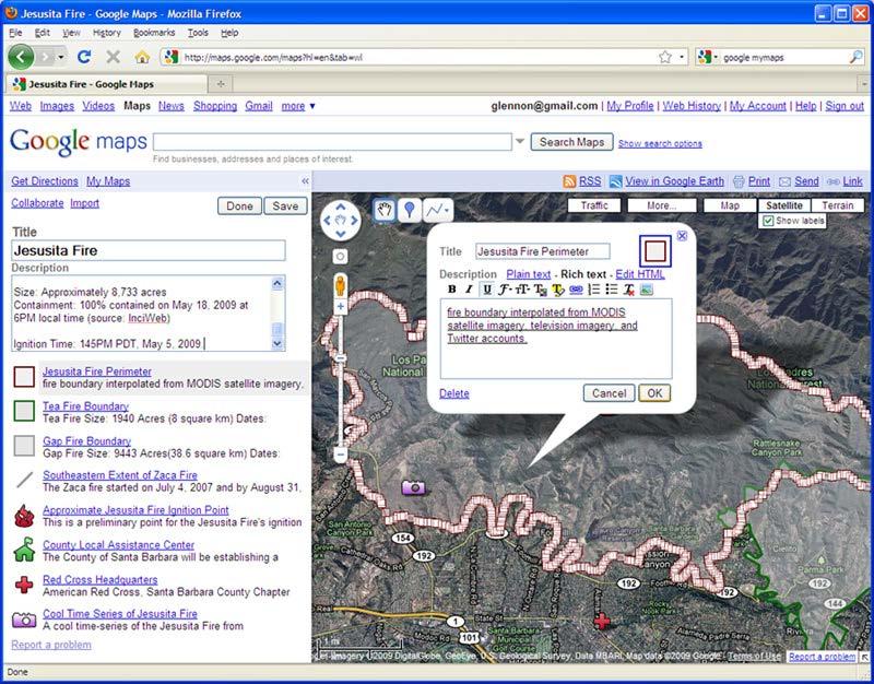
28 Hierarchical relationship between Paris and its constituent places

29 Events Spatial footprints of Mardi Gras Temporal footprints of photos with tags "Mardi Gras" or "Shrove Tuesday"
30 Place and footprints Spatial footprints that are harvested from geotagged Flickr photos can be used to investigate the spatial extent of individual places and associated spatial uncertainty in footprints. Case study: Paris and its six constituent places. In the location density surfaces, peaks on footprint density surfaces suggest a high degree of agreement on that location. Hierarchical relationships and events can also be inferred from spatial footprints.
31 Place and footprints Implications: It is a non-intrusive method of data collection Spatial knowledge of places may complement and improve existing gazetteer It can not only answer questions regarding location of a single place, but also questions about relations between places. Limitations: User-generated spatial data No sampling strategy is adopted Only places with a sufficient amount of data can be studied
32 Emergency response Disasters: Hurricane Katrina, 2005 The Wenchuan Earthquake, China, 2008 The Haiti and Chile Earthquakes, 2010 Time is critical What information would you want to know if you are a victim who needs help? if you are an emergency manager? Location!! of resources, of victims, etc.
33 Geographic information for emergency response Data needs: reliable, accurate, timely geographic data Data problems: Data provided by government: inadequate Data from remote sensing: only phenomena visible from above Not enough GIS data experts Not enough professional emergency workers The response efforts during Katrina were significantly hampered by a lack of information from the ground (a report to the US Congress on Hurricane Katrina, by Secretary of Homeland Security Michael Chertoff, 2005)
34 Information sharing in emergencies Important to facilitate coordination Important between emergency managers and local residents Important for local residents for emotional reasons Existing communication channels: neither sufficient nor adequately used Alternative: online and mobile social networking services

35 Jesusita Fire May 5-18, ,733 acres burned 80 homes destroyed; 15 homes damaged Estimated costs $17 million

36 Data about Jesusita Fire Community web: Independent Social networks: Twitter, Flickr, Facebook Television and radio: both traditional and online Government and official outlets Satellite imagery Newspaper stories Conversations with first and secondhand eyewitnesses
37

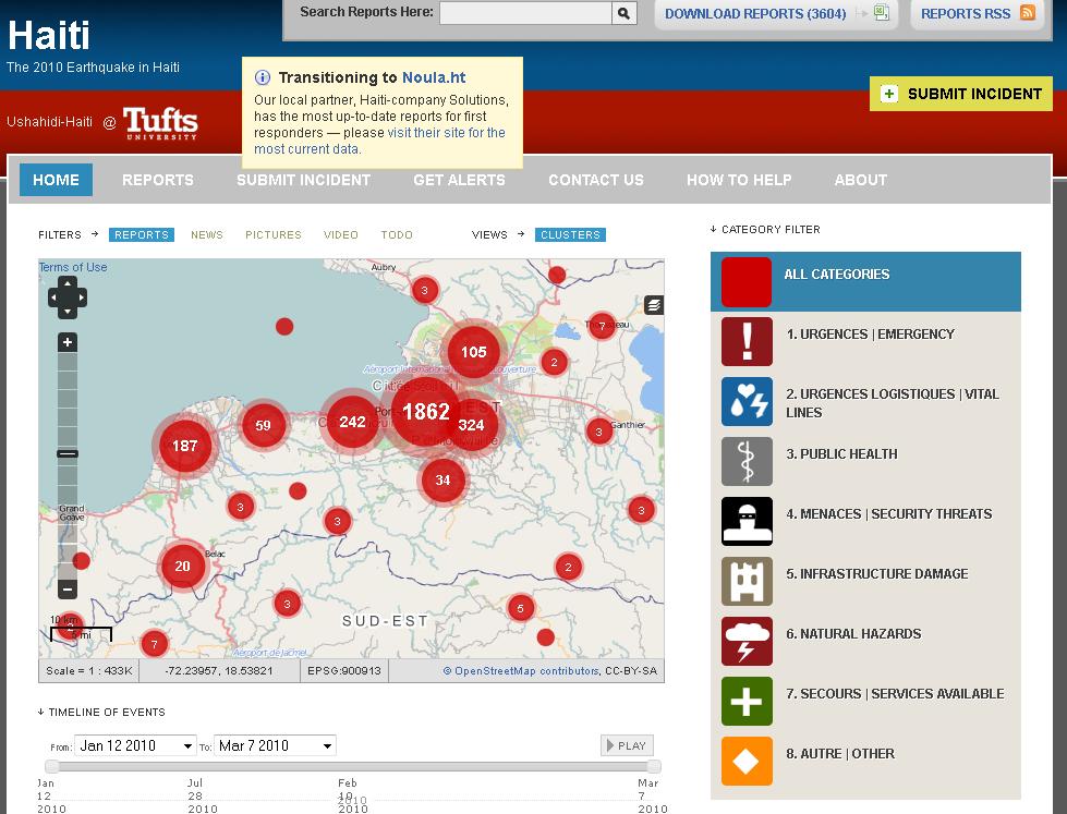
38 2010 Haiti 7.0 Mw earthquake 16:53 local time on Tuesday, 12 January 2010 three million people were affected an estimated 316,000 people died 300,000 were injured and 1,000,000 made homeless 250,000 residences and 30,000 commercial buildings collapsed or severely damaged.
39

40 OpenStreetMap, Haiti Before the 2010 Earthquake

41 OpenStreetMap, Haiti January 14, 2010, within only 48 hours
 integrated")
42 Outcomes Complementary technologies (open geographic data and reports from victims) integrated Fast cycle, open maps and data saved lives Partnerships and community formed

 By")
43 Can social media rescue street children? Street Children are often excluded from the mainstream society. Child beggars are prevailing in China. (1 to 1.5 million homeless with 20,000 children abducted every year) By Xining Yang, California State University, Chico

44 Twitter Baby come home: missing children database
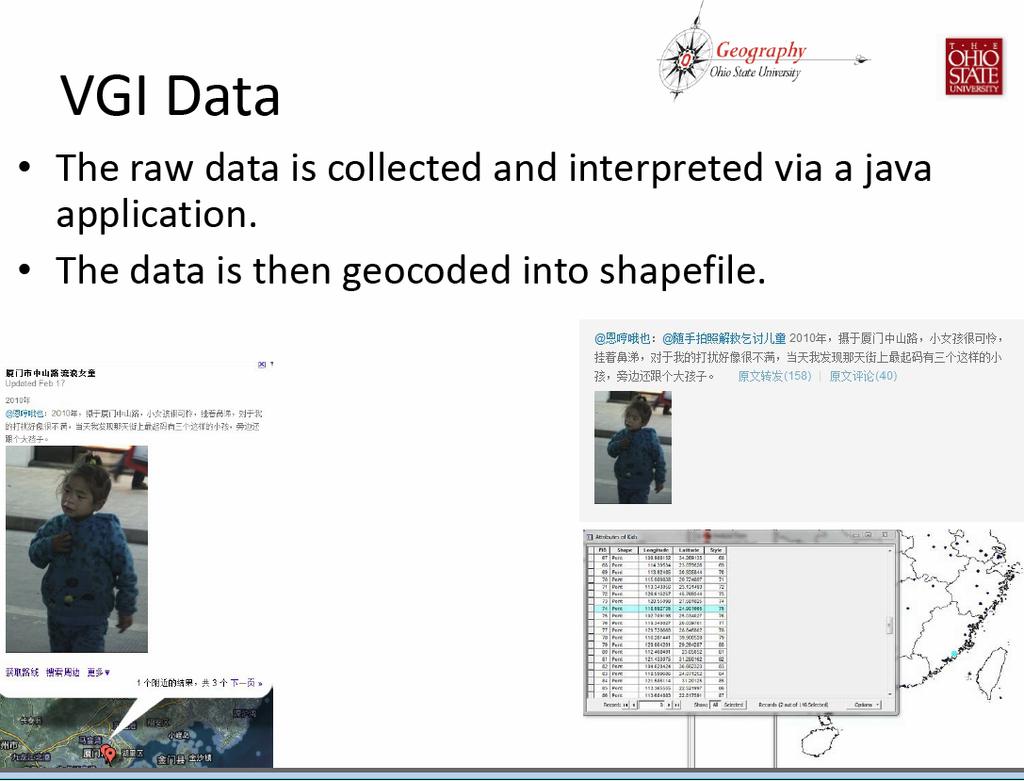
45
46 By Xining Yang
47 Challenges (Li and Goodchild, 2010, Goodchild and Li, 2012) data access and data quality How to discover relevant information? How to validate VGI? How to synthesize geographic data Uncertainty Data conflation How to use social networks to support crowdsourcing mapping? Privacy
48 Inferred home and work locations from tweets (Li and Goodchild, 2013) Linked the georeferenced tweets with land use data provided by Southern California Association of Governments (SCAG). Land use data in LA contain use code at the parcel level. Major categories of land use: vacant land, single family residence, multiple dwelling, commercial, industrial, agricultural, exempt property, natural resources, and others. The parcel with the largest number of tweets was regarded as a main location of user activities.
49 Percentage of georeferenced tweets and land use in the parcel with most tweets for the top 5 users User rank Percentage of georeferenced tweets in the parcel Land use of the parcel % Single family residence % Apartment complex % Combination Stores and Offices % Apartment complex % Apartment complex

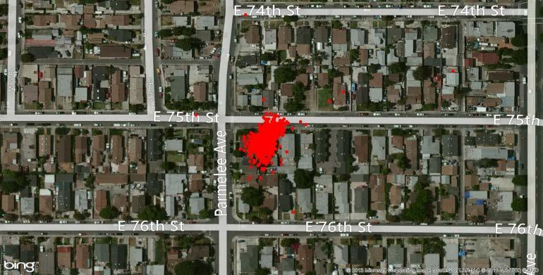
50 Georeferenced tweets for the first user
51 Changed perception of privacy? Inferred home and work locations of individuals from georeferenced tweets Two possible reasons: First, they are not aware of the disclosure of geopersonal information Second, they are willing to share spatial footprints due to low concern of geographic privacy Less worried about geopersonal information compared to other sensitive personal information such as bank accounts Give out personal information to take advantage of convenience and efficiency, e.g., cell phones, credit cards, location search, etc.
52 Home location may no longer be a secret. User contributed locations used to predict real-time traffic Sometimes difficult or even disadvantageous not to share geopersonal information Many people are willing to share geographic information when using location-based services Geoprivacy may be redefined Location sharing is a choice, not privacy violation


53 Geovisualizing emotional response to policy A study of the patient protection and affordable care act By Brent Dell, CSU Long Beach
54 Research Questions Patient Protection and Affordable Care Act Is there a geographic trend in the distribution of emotional response to the PPACA? Is there a correlation between the emotional responses and demographic, economic, or political factors? Twitter Do PPACA consumers respond to their experiences on the internet, or more specifically twitter? Is twitter an accurate or reliable sampling of the PPACA consumer base?
55 Future trends Location-based services in mobile devices: marketing analysis, vacation spots Know the position of almost everything Let geospatial technologies do the geo part, we people are responsible for the social part Volunteered spatial analysis and modeling in various aspects of life Decision-making based on crowd-sourced spatial data and analytics
The Future of Geography in an. Society. Michael F. Goodchild University of California Santa Barbara
 The Future of Geography in an Emerging Information-Technology Society Michael F. Goodchild University of California Santa Barbara Geographic technologies Positioning i on the Earth s surface GPS, RFID
Citizens as Sensors: Web 2.0 and the World of Volunteered Geography. Michael F. Goodchild University of California Santa Barbara
 Citizens as Sensors: Web 2.0 and the World of Volunteered Geography Michael F. Goodchild University of California Santa Barbara How is geographic information created? By authorities USGS NGA Ordnance Survey
Geographic Information Systems and Science: Today and Tomorrow. Michael F. Goodchild University of California Santa Barbara
 Geographic Information Systems and Science: Today and Tomorrow Michael F. Goodchild University of California Santa Barbara Geospatial technologies Positioning on the Earth s surface GPS, RFID Acquisition
Michael F. Goodchild University of California Santa Barbara
 The Changing Face of GIS Michael F. Goodchild University of California Santa Barbara 1 Two topics New data sources Critical spatial thinking 2 How is geographic information created? By authorities and
Vision 2020: Focus on the Future. Michael F. Goodchild University of California Santa Barbara
 Vision 2020: Focus on the Future Michael F. Goodchild University of California Santa Barbara A little context Gore, Earth in the Balance, 1992 a single portal to Earth information Fall 1997 Tom Kalil,
Discovery and Access of Geospatial Resources using the Geoportal Extension. Marten Hogeweg Geoportal Extension Product Manager
 Discovery and Access of Geospatial Resources using the Geoportal Extension Marten Hogeweg Geoportal Extension Product Manager DISCOVERY AND ACCESS USING THE GEOPORTAL EXTENSION Geospatial Data Is Very
Space-adjusting Technologies and the Social Ecologies of Place
 Space-adjusting Technologies and the Social Ecologies of Place Donald G. Janelle University of California, Santa Barbara Reflections on Geographic Information Science Session in Honor of Michael Goodchild
Web 2.0, map production & publishing and geospatial information dissemenation
 Web 2.0, map production & publishing and geospatial information dissemenation Professor William Cartwright President, International Cartographic Association William Cartwright 18th UNRCC for Asia and the
Detecting Origin-Destination Mobility Flows From Geotagged Tweets in Greater Los Angeles Area
 Detecting Origin-Destination Mobility Flows From Geotagged Tweets in Greater Los Angeles Area Song Gao 1, Jiue-An Yang 1,2, Bo Yan 1, Yingjie Hu 1, Krzysztof Janowicz 1, Grant McKenzie 1 1 STKO Lab, Department
Michael F. Goodchild University of California Santa Barbara
 The Changing Face of GIS Michael F. Goodchild University of California Santa Barbara 1 Two topics New data sources Critical spatial thinking 2 How is geographic information created? By authorities and
Cartographic and Geospatial Futures
 Cartographic and Geospatial Futures 1. Web Cartography, WebGIS, & Virtual Globes--New Roles for Maps, GIS, and GIS professionals 2. Map Mashups, the Neo Neo-geography Movement, & Crowd-sourcing Geospatial
Key Points Sharing fosters participation and collaboration Metadata has a big role in sharing Sharing is not always easy
 Sharing Resources Geoff Mortson esri, Inc. SDI Solutions Team Key Points Sharing fosters participation and collaboration Metadata has a big role in sharing Sharing is not always easy Data Sharing is Good
Tools to Assess Local Health Needs. Richard Leadbeater, Esri NACo 2011 Healthy Counties Forum December 1, 2011
 Tools to Assess Local Health Needs Richard Leadbeater, Esri NACo 2011 Healthy Counties Forum December 1, 2011 Richard Leadbeater currently holds the position of Industry Solutions Manager with Esri. He
GIS Lecture 5: Spatial Data
 GIS Lecture 5: Spatial Data GIS 1 Outline Vector Data Formats Raster Data Formats Map Projections Coordinate Systems US Census geographic files US Census data files GIS Data Sources GIS 2 Vector Data Formats
Understanding China Census Data with GIS By Shuming Bao and Susan Haynie China Data Center, University of Michigan
 Understanding China Census Data with GIS By Shuming Bao and Susan Haynie China Data Center, University of Michigan The Census data for China provides comprehensive demographic and business information
Putting the U.S. Geospatial Services Industry On the Map
 Putting the U.S. Geospatial Services Industry On the Map December 2012 Definition of geospatial services and the focus of this economic study Geospatial services Geospatial services industry Allow consumers,
Compact guides GISCO. Geographic information system of the Commission
 Compact guides GISCO Geographic information system of the Commission What is GISCO? GISCO, the Geographic Information System of the COmmission, is a permanent service of Eurostat that fulfils the requirements
Spatial Data Science. Soumya K Ghosh
 Workshop on Data Science and Machine Learning (DSML 17) ISI Kolkata, March 28-31, 2017 Spatial Data Science Soumya K Ghosh Professor Department of Computer Science and Engineering Indian Institute of Technology,
How Every Library Can Use Web GIS
 How Every Library Can Use Web GIS Eva Dodsworth Geospatial Data Services Librarian University of Waterloo Library Courtney Lundrigan Librarian Intern/MLIS Candidate Ryerson University Library/University
The Integrated Ge spatial Information Framework to the strengthening of NSDI, Mongolia
 Young Geospatial Professionals Summit 21 NOV 2018 The Integrated Ge spatial Information Framework to the strengthening of NSDI, Mongolia BAYARMAA ENKHTUR Geospatial information and technology department
California Reality and Nova Scotia Dreaming. Michael F. Goodchild University of California Santa Barbara
 California Reality and Nova Scotia Dreaming Michael F. Goodchild University of California Santa Barbara 1 The geospatial world Remote sensing Geographic information systems Automated cartography Global
Assessing pervasive user-generated content to describe tourist dynamics
 Assessing pervasive user-generated content to describe tourist dynamics Fabien Girardin, Josep Blat Universitat Pompeu Fabra, Barcelona, Spain {Fabien.Girardin, Josep.Blat}@upf.edu Abstract. In recent
How a Media Organization Tackles the. Challenge Opportunity. Digital Gazetteer Workshop December 8, 2006
 A Case-Study-In-Process: How a Media Organization Tackles the Georeferencing Challenge Opportunity Digital Gazetteer Workshop December 8, 2006 to increase and diffuse geographic knowledge 1888 to 2006:
Geographic Data Science - Lecture II
 Geographic Data Science - Lecture II (New) Spatial Data Dani Arribas-Bel "Yesterday" Introduced the (geo-)data revolution What is it? Why now? The need of (geo-)data science to make sense of it all Today
VGIscience Summer School Interpretation, Visualisation and Social Computing of Volunteered Geographic Information (VGI)
") VGIscience Summer School Interpretation, Visualisation and Social Computing of Volunteered Geographic Information (VGI) TU Dresden, 11.-15. September 2017 Welcome PhD students working on research topics
VGIscience Summer School Interpretation, Visualisation and Social Computing of Volunteered Geographic Information (VGI) TU Dresden, 11.-15. September 2017 Welcome PhD students working on research topics
Techniques for Science Teachers: Using GIS in Science Classrooms.
 Techniques for Science Teachers: Using GIS in Science Classrooms. After ESRI, 2008 GIS A Geographic Information System A collection of computer hardware, software, and geographic data used together for
GIS CONCEPTS Part I. GIS ON THE WEB Part II
 Week 2 GIS CONCEPTS Part I GIS ON THE WEB Part II topics of the week part I GIS functions and GIS data Spatial relationships Organizing convention for spatial data Store Information by thematic layers
Oman NSDI Supporting Economic Development. Saud Al-Nofli Director of Spatial Data Directorate General of NSDI, NCSI
 Oman NSDI Supporting Economic Development 2017 Saud Al-Nofli Director of Spatial Data Directorate General of NSDI, NCSI "It s critical to make correct decisions the first time to optimize the Investments
Geographical Bias on Social Media and Geo-Local Contents System with Mobile Devices
 212 45th Hawaii International Conference on System Sciences Geographical Bias on Social Media and Geo-Local Contents System with Mobile Devices Kazunari Ishida Hiroshima Institute of Technology k.ishida.p7@it-hiroshima.ac.jp
Smart Citizens. Maria Antonia Brovelli Politecnico di Milano, Italy
 Smart Citizens Maria Antonia Brovelli Politecnico di Milano, Italy UN-GGIM Academic Network Forum Secure Land Rights and Smart Cities: Making It Work for Sustainable Development New York, 31 July 2017
A General Framework for Conflation
 A General Framework for Conflation Benjamin Adams, Linna Li, Martin Raubal, Michael F. Goodchild University of California, Santa Barbara, CA, USA Email: badams@cs.ucsb.edu, linna@geog.ucsb.edu, raubal@geog.ucsb.edu,
GIScience: Current Technology. Michael F. Goodchild University of California Santa Barbara
 GIScience: Current Technology Michael F. Goodchild University of California Santa Barbara What is a GIS? A class of software designed to handle geographic information and perform virtually any conceivable
Application of WebGIS and VGI for Community Based Resources Inventory. Jihn-Fa Jan Department of Land Economics National Chengchi University
 Application of WebGIS and VGI for Community Based Resources Inventory Jihn-Fa Jan Department of Land Economics National Chengchi University OUTLINE Introduction Methodology Results Conclusions 2 MOTIVATION
Spatial Big Data. Amol G. Deshmukh Geomatics Specialist
 6% Spatial Big Data Amol G. Deshmukh Geomatics Specialist % Everyone talks about it, nobody really knows how to use it, everyone thinks everyone else is using it, so everyone claims they are using it...
Exploring Urban Areas of Interest. Yingjie Hu and Sathya Prasad
 Exploring Urban Areas of Interest Yingjie Hu and Sathya Prasad What is Urban Areas of Interest (AOIs)? What is Urban Areas of Interest (AOIs)? Urban AOIs exist in people s minds and defined by people s
Creating a Staff Development Plan with Esri
 Creating a Staff Development Plan with Esri Michael Green David Schneider Guest Presenter: Shane Feirer, University of California Esri UC 2014 Technical Workshop Agenda What is a Staff Development Plan?
Write a report (6-7 pages, double space) on some examples of Internet Applications. You can choose only ONE of the following application areas:
 on some examples of Internet Applications. You can choose only ONE of the following application areas:") UPR 6905 Internet GIS Homework 1 Yong Hong Guo September 9, 2008 Write a report (6-7 pages, double space) on some examples of Internet Applications. You can choose only ONE of the following application
UPR 6905 Internet GIS Homework 1 Yong Hong Guo September 9, 2008 Write a report (6-7 pages, double space) on some examples of Internet Applications. You can choose only ONE of the following application
Lesson 16: Technology Trends and Research
 http://www.esri.com/library/whitepapers/pdfs/integrated-geoenabled-soa.pdf GEOG DL582 : GIS Data Management Lesson 16: Technology Trends and Research Overview Learning Objective Questions: 1. Why is integration
WMO. Key Elements of PWS and Effective EWS. Haleh Haleh Kootval Chief, PWS Programme
 WMO Key Elements of PWS and Effective EWS Haleh Haleh Kootval Chief, PWS Programme Workshop Objectives This workshop is all about Service Delivery and becoming excellent at it through: Sharing experiences
What is special about geospatial? or A discipline in constant transition
 What is special about geospatial? or A discipline in constant transition Marinos Kavouras NTUA Ensuring the Rapid Response to Change, Ensuring the Surveyor of Tomorrow FIG 2015 Several paradigm shifts
2018 NASCIO Award Submission Category: Cross-Boundary Collaboration and Partnerships. Project Title: Tennessee Wildfires: A Coordinated GIS Response
 2018 NASCIO Award Submission Category: Cross-Boundary Collaboration and Partnerships Project Title: Tennessee Wildfires: A Coordinated GIS Response Sevier County, Tennessee State of Tennessee, Emergency
Sharing GIS to Empower the End User David Wray, Roanoke County, Virginia
 Sharing GIS to Empower the End User David Wray, Roanoke County, Virginia Sharing GIS to Empower the End User Roanoke County, Virginia Roanoke County, Virginia Population: 92,901 Area: 251 Square Miles
The Spatial Web: Visions for a Geospatial World. Michael F. Goodchild Walton Fellow National Centre for Geocomputation
 The Spatial Web: Visions for a Geospatial World Michael F. Goodchild Walton Fellow National Centre for Geocomputation Outline Context Current technology My own research Technological vision Social issues
Building a National Data Repository
 Building a National Data Repository Mladen Stojic, Vice President - Geospatial 1/30/2013 2012 Intergraph Corporation 1 Information has meaning and gives power only when shared and distributed. Information,
Geospatial Analysis of Job-Housing Mismatch Using ArcGIS and Python
 Geospatial Analysis of Job-Housing Mismatch Using ArcGIS and Python 2016 ESRI User Conference June 29, 2016 San Diego, CA Jung Seo, Frank Wen, Simon Choi and Tom Vo, Research & Analysis Southern California
Using spatial-temporal signatures to infer human activities from personal trajectories on location-enabled mobile devices
 Using spatial-temporal signatures to infer human activities from personal trajectories on location-enabled mobile devices Yingjie Hu 1, Wenwen Li 2, Krzysztof Janowicz 1, Kathleen Deutsch 1, Grant McKenzie
United States Forest Service Makes Use of Avenza PDF Maps App to Reduce Critical Time Delays and Increase Response Time During Natural Disasters
 CASE STUDY For more information, please contact: Christine Simmons LFPR Public Relations www.lfpr.com (for Avenza) 949.502-7750 ext. 270 Christines@lf-pr.com United States Forest Service Makes Use of Avenza
Open spatial data infrastructure
 Open spatial data infrastructure a backbone for digital government Thorben Hansen Geomatikkdagene 2018 Stavanger 13.-15. mars Spatial Data Infrastructure definition the technology, policies, standards,
The Global Statistical Geospatial Framework and the Global Fundamental Geospatial Themes
 The Global Statistical Geospatial Framework and the Global Fundamental Geospatial Themes Sub-regional workshop on integration of administrative data, big data and geospatial information for the compilation
Welcome. C o n n e c t i n g
 Welcome C o n n e c t i n g YOU D i s c i p l i n e s Why is This Meeting......So Important Now? OUR WORLD Is Increasingly Challenged The Evidence Is Clear We Need Better Understanding and More Collaboration
Mapping the Urban Farming in Chinese Cities:
 Submission to EDC Student of the Year Award 2015 A old female is cultivating the a public green space in the residential community(xiaoqu in Chinese characters) Source:baidu.com 2015. Mapping the Urban
ENV208/ENV508 Applied GIS. Week 1: What is GIS?
 ENV208/ENV508 Applied GIS Week 1: What is GIS? 1 WHAT IS GIS? A GIS integrates hardware, software, and data for capturing, managing, analyzing, and displaying all forms of geographically referenced information.
Geography for the 2020 Round of Census
 Boundaries Key Census Data EA Id Population Male Female EA Id Area EA Id Num HH Avg HH size Geography for the 2020 Round of Census Linda Peters, Esri lpeters@esri.com Integration of Statistical and Geospatial
GEOGRAPHIC INFORMATION SYSTEMS Session 8
 GEOGRAPHIC INFORMATION SYSTEMS Session 8 Introduction Geography underpins all activities associated with a census Census geography is essential to plan and manage fieldwork as well as to report results
Hurricane Preparation and Recovery. October 11, 2011 Jon Nance, Chief Engineer, NCDOT
 Hurricane Preparation and Recovery October 11, 2011 Jon Nance, Chief Engineer, NCDOT North Carolina & Severe Weather Our state often bears the brunt of storms, which include: Ice storms Snow storms Heavy
Google Maps and Beyond
 Google Maps and Beyond Aaron Paul First American Title apaul@firstam.com 2015 APRA Symposium Association of Professional Reserve Analysts May 2 nd, 2015 Google Maps and Beyond - Overview Business case
A route map to calibrate spatial interaction models from GPS movement data
 A route map to calibrate spatial interaction models from GPS movement data K. Sila-Nowicka 1, A.S. Fotheringham 2 1 Urban Big Data Centre School of Political and Social Sciences University of Glasgow Lilybank
GEOGRAPHIC INFORMATION SYSTEMS
 GEOGRAPHIC INFORMATION SYSTEMS 4-H Round-Up Community Transitions Workshop Daniel Hanselka June 14, 2011 Goals of the Workshop Answer the question: What is GIS? Uses of GIS. Some of the Common Terminology
Your web browser (Safari 7) is out of date. For more security, comfort and. the best experience on this site: Update your browser Ignore
 is out of date. For more security, comfort and. the best experience on this site: Update your browser Ignore") Your web browser (Safari 7) is out of date. For more security, comfort and Activityengage the best experience on this site: Update your browser Ignore Introduction to GIS What is a geographic information
Your web browser (Safari 7) is out of date. For more security, comfort and Activityengage the best experience on this site: Update your browser Ignore Introduction to GIS What is a geographic information
Data Origin. How to obtain geodata? Ron van Lammeren CGI-GIRS 0910
 Data Origin How to obtain geodata? Ron van Lammeren CGI-GIRS 0910 Spatial Data interest Improvement of policy making. ± 90% of all information used by government has spatial characteristics SPATIAL INFORMATION
GIS = Geographic Information Systems;
 What is GIS GIS = Geographic Information Systems; What Information are we talking about? Information about anything that has a place (e.g. locations of features, address of people) on Earth s surface,
Introduction to GIS. Phil Guertin School of Natural Resources and the Environment GeoSpatial Technologies
 Introduction to GIS Phil Guertin School of Natural Resources and the Environment dguertin@cals.arizona.edu Mapping GeoSpatial Technologies Traditional Survey Global Positioning Systems (GPS) Remote Sensing
Title: Storm of the Century: Documenting the 1993 Superstorm
 A. PAIIF 2011 Cover Page Title: Storm of the Century: Documenting the 1993 Superstorm Point of Contact: Name: Alex Granger Email: alex.granger@noaa.gov Phone Number: 571-555-9278 Mailing Address: Research
FROM PHYSICAL TO DIGITAL SPACES Exploring space-time mobility through a telegeomonitoring approach
 1 July 2016 Session 7: The potential of open data and big data for territorial information designed to respond to the PT07 Mainstreaming Gender Equality and Promoting Work Life Balance (2nd Open Call -Support
Unit 1, Lesson 2. What is geographic inquiry?
 What is geographic inquiry? Unit 1, Lesson 2 Understanding the way in which social scientists investigate problems will help you conduct your own investigations about problems or issues facing your community
DEVELOPMENT OF GPS PHOTOS DATABASE FOR LAND USE AND LAND COVER APPLICATIONS
 DEVELOPMENT OF GPS PHOTOS DATABASE FOR LAND USE AND LAND COVER APPLICATIONS An Ngoc VAN and Wataru TAKEUCHI Institute of Industrial Science University of Tokyo 4-6-1 Komaba, Meguro-ku, Tokyo 153-8505 Japan
DATA SOURCES AND INPUT IN GIS. By Prof. A. Balasubramanian Centre for Advanced Studies in Earth Science, University of Mysore, Mysore
 DATA SOURCES AND INPUT IN GIS By Prof. A. Balasubramanian Centre for Advanced Studies in Earth Science, University of Mysore, Mysore 1 1. GIS stands for 'Geographic Information System'. It is a computer-based
Canadian Board of Examiners for Professional Surveyors Core Syllabus Item C 5: GEOSPATIAL INFORMATION SYSTEMS
 Study Guide: Canadian Board of Examiners for Professional Surveyors Core Syllabus Item C 5: GEOSPATIAL INFORMATION SYSTEMS This guide presents some study questions with specific referral to the essential
INTRODUCTION TO HUMAN GEOGRAPHY. Chapter 1
 INTRODUCTION TO HUMAN GEOGRAPHY Chapter 1 What Is Human Geography? The study of How people make places How we organize space and society How we interact with each other in places and across space How we
THE STUDY ON 4S TECHNOLOGY IN THE COMMAND OF EARTHQUAKE DISASTER EMERGENCY 1
 THE STUDY ON 4S TECHNOLOGY IN THE COMMAND OF EARTHQUAKE DISASTER EMERGENCY 1 Zhou Wensheng 1, Huang Jianxi 2, Li Qiang 3, Liu Ze 3 1 Associate Professor, School of Architecture, Tsinghua University, Beijing.
Mobility Analytics through Social and Personal Data. Pierre Senellart
 Mobility Analytics through Social and Personal Data Pierre Senellart Session: Big Data & Transport Business Convention on Big Data Université Paris-Saclay, 25 novembre 2015 Analyzing Transportation and
GEOMATICS. Shaping our world. A company of
 GEOMATICS Shaping our world A company of OUR EXPERTISE Geomatics Geomatics plays a mayor role in hydropower, land and water resources, urban development, transport & mobility, renewable energy, and infrastructure
What is GIS? Introduction to data. Introduction to data modeling
 What is GIS? Introduction to data Introduction to data modeling 2 A GIS is similar, layering mapped information in a computer to help us view our world as a system A Geographic Information System is a
Cutting Edge Engineering for Modern Geospatial Systems Rear Admiral Dr. S Kulshrestha, retd
 Cutting Edge Engineering for Modern Geospatial Systems Rear Admiral Dr. S Kulshrestha, retd 11 Jun 2015 GeoIntelligence Asia 2015 The technology would become so pervasive that it becomes a part of you
Data Origin. Ron van Lammeren CGI-GIRS 0910
 Data Origin Ron van Lammeren CGI-GIRS 0910 How to obtain geodata? Geo data initiative Executive Order 12906, "Coordinating Geographic Data Acquisition and Access: The National Spatial Data Infrastructure,"
GEOMATICS AND DISASTER MANAGEMENT: Early Impact assessment in Haiti
 GEOMATICS AND DISASTER MANAGEMENT: Early Impact assessment in Haiti We will talk about... Post-disaster response: the main questions to be answered Post-disaster rapid mapping: the role of Geomatics The
Neighborhood Locations and Amenities
 University of Maryland School of Architecture, Planning and Preservation Fall, 2014 Neighborhood Locations and Amenities Authors: Cole Greene Jacob Johnson Maha Tariq Under the Supervision of: Dr. Chao
Geographic Knowledge Discovery Using Ground-Level Images and Videos
 This work was funded in part by a DOE Early Career award, an NSF CAREER award (#IIS- 1150115), and a PECASE award. We gratefully acknowledge NVIDIA for their donated hardware. Geographic Knowledge Discovery
Data Creation and Editing
 11.520:A Workshop on Geographical Information Systems 1.188: Urban Planning and Social Science Laboratory Data Creation and Editing Based in part on notes by Prof. Joseph Ferreira and Michael Flaxman Lulu
Int er net Saf et y Tip s
 BE CAREFUL AS: Facebook oft en means People oft en pret end t o be people t hey are not so be wary of t his!! Int er net Saf et y Tip s N ever accept people you do not know. Never give out your real name
Emerging issues to use geospatial initiatives in the societal context of disaster managing **
 ADVANCE UNEDITED VERSION UNITED NATIONS E/CONF.103/3/Add.1 ECONOMIC AND SOCIAL COUNCIL Tenth United Nations Regional Cartographic Conference for the Americas New York, 19-23, August 2013 Item 6 (a) of
Geospatial natural disaster management
 Geospatial natural disaster management disasters happen. are you ready? Natural disasters can strike almost anywhere at any time, with no regard to a municipality s financial resources. These extraordinarily
Remote Sensing and Incident Support. Department of Homeland Security February 22, 2013
 Remote Sensing and Incident Support Department of Homeland Security February 22, 2013 Introductions and Goals Today s Webcast will be Presented by: Chris Barnard DHS Remote Sensing Advisor Chris Vaughan
Evaluating Travel Impedance Agreement among Online Road Network Data Providers
 Evaluating Travel Impedance Agreement among Online Road Network Data Providers Derek Marsh Eric Delmelle Coline Dony Department of Geography and Earth Sciences University of North Carolina at Charlotte
Future Proofing the Provision of Geoinformation: Emerging Technologies
 Future Proofing the Provision of Geoinformation: Emerging Technologies An Exchange Forum with the Geospatial Industry William Cartwright Chair JBGIS Second High Level Forum on Global Geospatial Information
2013 AND 2025 THE FUTURE OF GIS
 THE FUTURE OF GIS 2013 AND 2025 What is the state of geospatial computing today? What are the issues today? Unresolved problems What will geospatial computing be like in 2025? What issues will be of concern
DATA DISAGGREGATION BY GEOGRAPHIC
 PROGRAM CYCLE ADS 201 Additional Help DATA DISAGGREGATION BY GEOGRAPHIC LOCATION Introduction This document provides supplemental guidance to ADS 201.3.5.7.G Indicator Disaggregation, and discusses concepts
CES Seminar 2016: Geospatial information services based on official statistics Key issues from the session II papers
 Norbert Rainer 64 th plenary session of the Conference of European Statisticians 28 April 2016, Paris CES Seminar 2016: Geospatial information services based on official statistics Key issues from the
geographic patterns and processes are captured and represented using computer technologies
 Proposed Certificate in Geographic Information Science Department of Geographical and Sustainability Sciences Submitted: November 9, 2016 Geographic information systems (GIS) capture the complex spatial
IAEG-SDGs WGGI Task Team Dec. 7, 2017, New York
 IAEG-SDGs WGGI Task Team Dec. 7, 2017, New York Contents What are G/A data? Role of G/A data Utilization Recommendations Outlook National Geospatial Data for SDGs Official data products generated by authoritative
IH 35 at Blanco River May 2015
 IH 35 at Blanco River May 2015 Presentation Objectives Background of historical damage assessment processes Introduction to Collector App ( Mat Peck) Collector App and Flood Damage Assessment (Katie Steele)
You are Building Your Organization s Geographic Knowledge
 You are Building Your Organization s Geographic Knowledge And Increasingly Making it Available Sharing Data Publishing Maps and Geo-Apps Developing Collaborative Approaches Citizens Knowledge Workers Analysts
What are the five components of a GIS? A typically GIS consists of five elements: - Hardware, Software, Data, People and Procedures (Work Flows)
") LECTURE 1 - INTRODUCTION TO GIS Section I - GIS versus GPS What is a geographic information system (GIS)? GIS can be defined as a computerized application that combines an interactive map with a database
LECTURE 1 - INTRODUCTION TO GIS Section I - GIS versus GPS What is a geographic information system (GIS)? GIS can be defined as a computerized application that combines an interactive map with a database
Applications: Introduction Task 1: Introduction to ArcCatalog Task 2: Introduction to ArcMap Challenge Question References
 CHAPTER 1 INTRODUCTION 1.1 GIS? 1.1.1 Components of a GIS 1.1.2 A Brief History of GIS 1.1.3 GIS Software Products Box 1.1 A List of GIS Software Producers and Their Main Products 1.2 GIS Applications
BROADBAND DEMAND AGGREGATION: PLANNING BROADBAND IN RURAL NORTHERN CALIFORNIA
 BROADBAND DEMAND AGGREGATION: PLANNING BROADBAND IN RURAL NORTHERN CALIFORNIA Steven J. Steinberg, Ph.D a,b, *, Rebecca Degagne a, M.S., Michael Gough a a Institute for Spatial Analysis, Humboldt State
GIS Monroe Geographic Information System March 14, 2018
 GIS Monroe Geographic Information System March 14, 2018 Goals Maintain Enterprise/County-wide geo-database Increase spatial accuracy of data Build and acquire more data layers Increase use of GIS; as another
Using Social Media for Geodemographic Applications
 Using Social Media for Geodemographic Applications Muhammad Adnan and Guy Lansley Department of Geography, University College London @gisandtech @GuyLansley Web: http://www.uncertaintyofidentity.com Outline
Purpose Study conducted to determine the needs of the health care workforce related to GIS use, incorporation and training.
 GIS and Health Care: Educational Needs Assessment Cindy Gotz, MPH, CHES Janice Frates, Ph.D. Suzanne Wechsler, Ph.D. Departments of Health Care Administration & Geography California State University Long
WELCOME. To GEOG 350 / 550 Introduction to Geographic Information Science: Third Lecture
 WELCOME To GEOG 350 / 550 Introduction to Geographic Information Science: Third Lecture 1 Lecture 3: Overview Geographic Information Systems (GIS) A brief history of GIS Sources of information for GIS
Presented by Mark Coding & Rohan Richards National Spatial Data Management Division, Jamaica Esri User Conference 2014
 Presented by Mark Coding & Rohan Richards National Spatial Data Management Division, Jamaica Esri User Conference 2014 Children continue to account for a large percentage of missing persons in Jamaica.