Using Social Media for Geodemographic Applications
|
|
|
- Margaret Mills
- 5 years ago
- Views:
Transcription


1 Using Social Media for Geodemographic Applications Muhammad Adnan and Guy Lansley Department of Geography, University Web:
2 Outline 1. Geodemographics and Social Media Geodemographics 2. Using Twitter Data for Geodemographics 3. Establishing Footfall Estimates across Cities 4. Identifying Bespoke Temporal Catchments of Social Media Users
3 Introduction Geodemographics Analysis of people by where they live [1] Night time characteristics of the population Social Media Geodemographics Moving beyond the night time geography Who: Ethnicity, Gender, and Age of social media users When: What time of day conversations happen Where: Where social media conversations happen [1] Sleight, P. (2004). Targetting Customers-How to Use Geodemographic and Lifestyle Data in Your Business.
4 Twitter ( Online social-networking and micro blogging service Launched in 2006 Users can send messages of 140 characters or less Approximately 200 million active users [2] 350 million tweets daily In 2012, UK and London were ranked 4 th and 3 rd, respectively, in terms of the number of posted tweets [3] [2] Twitter What is Twitter?. Retrieved 31st December, 2012, from [3] Bennet, S Revealed: The Top 20 Countries and Cities of Twitter [STATS]. Retrieved 31st December, 2012, from
5 Data available through the Twitter API User Creation Date Followers Friends User ID Language Location Name Screen Name Time Zone Geo Enabled Latitude Longitude Tweet date and time Tweet text
6 47 million geo-tagged tweets (Sept 2012 March 2013)

7 8 million geo-tagged tweets (Sept 2012 Feb 2013)
8 Analysing Names on Twitter A family name is a statement of the bearer s cultural, ethnic, and linguistic identity [4] Some examples of NAME variations on Twitter Real Names Fake Names Kevin Hodge Andre Alves Jose de Franco Carolina Thomas, Dr. Prof. Martha Del Val Fabíola Sanchez Fernandes Castor 5. WHAT IS LOVE? MysticMind KIRILL_aka_KID Vanessa Justin Bieber Home [4] Mateos P, Longley P A, O Sullivan D Ethnicity and population structure in personal naming networks. PloS ONE (Public Library of Science) 6 (9) e22943.
9 Classifying Twitter Names to Ethnic Origins Applied ONOMAP ( on forename surname pairs [5] Onomap was created by clustering names of 1 billion individuals around the world Kevin Hodge (English) Pablo Mateos (Spanish) [5] Mateos P, Longley P A, O Sullivan D Ethnicity and population structure in personal naming networks. PloS ONE (Public Library of Science) 6 (9) e22943.
10 Top 10 Ethnic Groups of Twitter Users

11 Twitter activity Patterns of various Ethnic Groups English Italian German French Portuguese Spanish Greek Turkish Pakistani Indian Bangladeshi Sikh [6] Adnan, M., Longley, P. A Featured Graphic: Tweets by different Ethnic Groups in Greater London". Environment and Planning A, 45 (7),
12 Age estimation from forenames Monica dataset provided by CACI Supplemented with birth certificate records
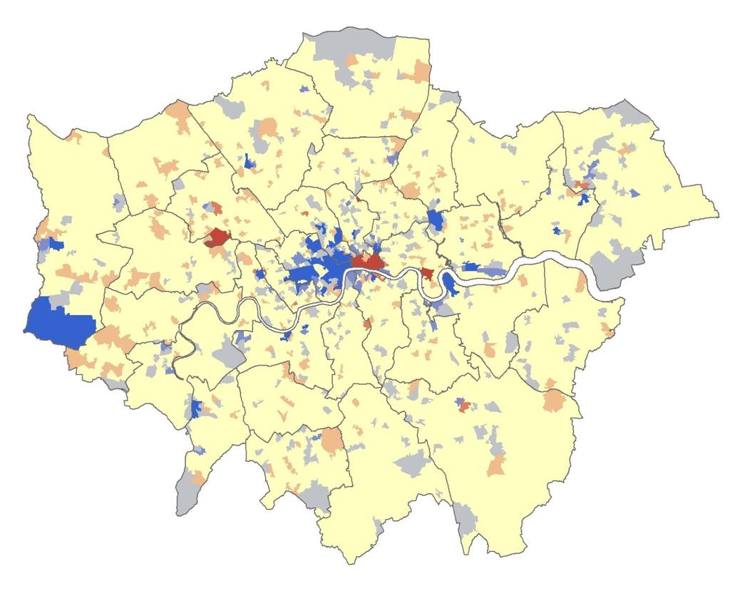
![Age distribution of Twitter users Twitter Users vs. 2011 Census (Greater London) [7] Longley, P., Adnan, M.](/docs-images/92/108685352/images/13-0.jpg ", Lansley, G. 2013. The geo-temporal demographics of Twitter usage. Environment and Planning A.")
13 Age distribution of Twitter users Twitter Users vs Census (Greater London) [7] Longley, P., Adnan, M., Lansley, G The geo-temporal demographics of Twitter usage. Environment and Planning A. (Paper Accepted)
14 Twitter demographics (Week Days) 7 a.m. to 6 p.m. during week days

15 Twitter demographics (Week Days) 7 a.m. to 6 p.m. during week days Edmonton Wood Green

16 Twitter demographics (Week Days) 7 a.m. to 6 p.m. during week days Ilford


17 Twitter demographics (Week Evenings) 6 p.m. to 11 p.m. during week days

18 Weekend Days Weekend Nights


19 Twitter #Hashtags Most common London football club hashtag
 Residential population aged 16 and above (2011 Census) Difference (Census 2011)")
20 Dispersal of activity (LSOA) 10:00 16:00 (Twitter) 20:00 0:00 (Twitter) Difference (Twitter 2013) Work day population (2011 Census) Residential population aged 16 and above (2011 Census) Difference (Census 2011) 20

21 Twitter over-representation Census Day Twitter Night 21
")
22 Geo-located social network data Twitter activity by land use category Generalised Land Use Database Residential Non-Domestic Transport Green Space Water Other From Longley, Adnan & Lansley (Forthcoming) 22
23 Interactive map of Twitter density (UK and Ireland) Online in a couple of weeks A display of aggregate geo-located tweets from a random selection of Tuesdays, Wednesdays and Thursdays throughout x200m Grid Switch between hours 23
24 Twitter: Weekday activity in London Temporal map of geo-located Tweets recorded on selected weekdays during the winter of 2012/13
25 25


26 26


27 Tweet content Content reflects Place Land use Activity Sentiment Language Content also reflect time and date Words can be aggregated to make a definitive classification of topics Note: the words Greater and London have been removed Retail Nightlife Eating out Entertainment Outdoor Tourism Transport Work Home


")
28 Specific time catchments E.g. Day-time catchment 1. Identify the unique ID of users frequently transmitting from a particular location at a given time or date range 2. Request their other activity through Twitter s API, filter by time/date 3. Aggregate Activity at Bishopsgate during weekdays (2013) The Twitter work-day time catchment of Bishopsgate 28


29 Waterloo Victoria St Pancras Paddington London Bridge Liverpool Street Kings Cross Euston 29


30 Inferring a residential catchment based on Twitter data First, extract the unique ID s of users have tweeted from inside the building Request these users other Tweets for a given time/date range Create a customer catchment by identifying all Tweets sent from domestic land uses at a given time E.g. ASDA in Clapham Junction The Twitter residential catchment of ASDA Supermarket at Clapham Junction 30
31 Twitter users are not a representative sample of the British population Sample size Precision of geo-location varies between handheld devices Signal availability Tweets do not always reflect the place where they are transmitted Demographic characteristics & home address are not recorded Ethics Limitations of Twitter Data 31
32 Twitter based MSc dissertations at UCL 2012/13 The validity of geo-referenced Twitter data for predicting footfall for retail Robert Lea (Sponsored by M&S) Investigating the usefulness of Twitter data in characterising and classifying land use within small areas in Greater London Conrad Ow An exploratory space-time analysis of abnormal Twitter events Thomas Wicks 32
33 Conclusion Social media dataset are a good resource for creating geo-temporal Geodemographics Issues of representation An insight into the residential and travel geographies of individuals An insight into the online behaviours / usage
34 Thank you for Listening Any Questions?
DM-Group Meeting. Subhodip Biswas 10/16/2014
 DM-Group Meeting Subhodip Biswas 10/16/2014 Papers to be discussed 1. Crowdsourcing Land Use Maps via Twitter Vanessa Frias-Martinez and Enrique Frias-Martinez in KDD 2014 2. Tracking Climate Change Opinions
Application Issues in GIS: the UCL Centre for Advanced Spatial Analysis. Paul Longley UCL
 Application Issues in GIS: the UCL Centre for Advanced Spatial Analysis Paul Longley UCL GIS: inclusive, shared understanding Geodemographics as a focus of interest Profiling public goods and services
UCL CENTRE FOR ADVANCED SPATIAL ANALYSIS. Mapping London. Oliver O Brien and James Cheshire. Society of Cartographers 48 th Annual Conference (UCL)
") UCL CENTRE FOR ADVANCED SPATIAL ANALYSIS Mapping London Oliver O Brien and James Cheshire Society of Cartographers 48 th Annual Conference (UCL) 5 September 2012 The Mapping London Blog A blog highlighting
UCL CENTRE FOR ADVANCED SPATIAL ANALYSIS Mapping London Oliver O Brien and James Cheshire Society of Cartographers 48 th Annual Conference (UCL) 5 September 2012 The Mapping London Blog A blog highlighting
December 3, Dipartimento di Informatica, Università di Torino. Felicittà. Visualizing and Estimating Happiness in
 : : Dipartimento di Informatica, Università di Torino December 3, 2013 : Outline : from social media Social media users generated contents represent the human behavior in everyday life, but... how to analyze
The geography of domestic energy consumption
 The geography of domestic energy consumption Anastasia Ushakova PhD student at CDRC UCL Ellen Talbot PhD student at CDRC Liverpool Some important research questions How can we classify energy consumption
Profiling Burglary in London using Geodemographics
 Profiling Burglary in London using Geodemographics C G Gale *1, A D Singleton 2 and P A Longley 3 1 UCL Department of Civil, Environmental & Geomatic Engineering 2 University of Liverpool Department of
Geographical Bias on Social Media and Geo-Local Contents System with Mobile Devices
 212 45th Hawaii International Conference on System Sciences Geographical Bias on Social Media and Geo-Local Contents System with Mobile Devices Kazunari Ishida Hiroshima Institute of Technology k.ishida.p7@it-hiroshima.ac.jp
Profiling Burglary in London using Geodemographics. Chris Gale 1, Alex Singleton 2, Paul Longley 1
 Profiling Burglary in London using Geodemographics Chris Gale 1, Alex Singleton 2, Paul Longley 1 1 2 Geodemographic Classifications A Geodemographic Classification: Simplifies a large and complex body
Advances in Geographic Data Science and Urban Analytics
 Advances in Geographic Data Science and Urban Analytics Alex Singleton Professor of Geographic Information Science Department of Geography and Planning Consumer Data Research Centre www.cdrc.ac.uk www.geographicdatascience.com
* Abstract. Keywords: Smart Card Data, Public Transportation, Land Use, Non-negative Matrix Factorization.
 Analysis of Activity Trends Based on Smart Card Data of Public Transportation T. N. Maeda* 1, J. Mori 1, F. Toriumi 1, H. Ohashi 1 1 The University of Tokyo, 7-3-1 Hongo Bunkyo-ku, Tokyo, Japan *Email:
Open Data Sources for Domain Specific Geodemographics
 Open Data Sources for Domain Specific Geodemographics Matthew D. Pratt 1, Paul A. Longley 1, James Cheshire 2, Chris Gale 1 1 Department of Geography, University College London, Gower Street, London, WC1E
Understanding and accessing 2011 census aggregate data
 Understanding and accessing 2011 census aggregate data 4 July 11:00 to 16:00 BST Justin Hayes and Richard Wiseman UK Data Service Census Support UK censuses provide an unparalleled resource of high quality
Towards real-time geodemographic information systems: design, analysis and evaluation
 Towards real-time geodemographic information systems: design, analysis and evaluation Muhammad Adnan Department of Geography University College London (UCL) Thesis submitted in the fulfillment of the requirement
The Building Blocks of the City: Points, Lines and Polygons
 The Building Blocks of the City: Points, Lines and Polygons Andrew Crooks Centre For Advanced Spatial Analysis andrew.crooks@ucl.ac.uk www.gisagents.blogspot.com Introduction Why use ABM for Residential
Exploring the Impact of Ambient Population Measures on Crime Hotspots
 Exploring the Impact of Ambient Population Measures on Crime Hotspots Nick Malleson School of Geography, University of Leeds http://nickmalleson.co.uk/ N.S.Malleson@leeds.ac.uk Martin Andresen Institute
What are we like? Population characteristics from UK censuses. Justin Hayes & Richard Wiseman UK Data Service Census Support
 What are we like? Population characteristics from UK censuses Justin Hayes & Richard Wiseman UK Data Service Census Support Who are we? Richard Wiseman UK Data Service / Jisc Justin Hayes UK Data Service
Improving Geographical Data Finder Using Tokenize Approach from GIS Map API
 Improving Geographical Data Finder Using Tokenize Approach from GIS Map API Antveer Kaur Department of computer science Banasthali University, Jaipur, Rajasthan, India bntsnghbrr940@gmail.com Shweta Kumari
DataShine Automated Thematic Mapping of 2011 Census Quick Statistics
 DataShine Automated Thematic Mapping of 2011 Census Quick Statistics Oliver O Brien, James Cheshire Department of Geography University College London UKDS Census Applications Conference, July 2015 Contents
SOCIAL MEDIA IN THE COMMUNICATIONS CENTRE
 SOCIAL MEDIA IN THE COMMUNICATIONS CENTRE Karen Gordon Gordon Strategy www.gordonstrategy.ca v 1 WHAT WE ARE GOING TO TALK ABOUT TODAY T h e s o c i a l m e d i a i n c i d e n t W h a t c a n h a p p
1. Richard Milton 2. Steven Gray 3. Oliver O Brien Centre for Advanced Spatial Analysis (UCL)
") UCL CENTRE FOR ADVANCED SPATIAL ANALYSIS Apps Delivering Information to Mass Audiences 1. Richard Milton 2. Steven Gray 3. Oliver O Brien Centre for Advanced Spatial Analysis (UCL) Scott Adams 1995 The
UCL CENTRE FOR ADVANCED SPATIAL ANALYSIS Apps Delivering Information to Mass Audiences 1. Richard Milton 2. Steven Gray 3. Oliver O Brien Centre for Advanced Spatial Analysis (UCL) Scott Adams 1995 The
Modelling Spatial Behaviour in Music Festivals Using Mobile Generated Data and Machine Learning
 Modelling Spatial Behaviour in Music Festivals Using Mobile Generated Data and Machine Learning Luis Francisco Mejia Garcia *1, Guy Lansley 2 and Ben Calnan 3 1 Department of Civil, Environmental & Geomatic
Discovering Geographical Topics in Twitter
 Discovering Geographical Topics in Twitter Liangjie Hong, Lehigh University Amr Ahmed, Yahoo! Research Alexander J. Smola, Yahoo! Research Siva Gurumurthy, Twitter Kostas Tsioutsiouliklis, Twitter Overview
Social Studies Mr. Poirier Introduction Test - Study Guide
 Social Studies Mr. Poirier Introduction Test - Study Guide Study Guide given in class on Monday, September 15, 2014 Test Date: Friday, September 19, 2014 I. Study the following Vocabulary Words to be defined:
Geographic Data Science - Lecture II
 Geographic Data Science - Lecture II (New) Spatial Data Dani Arribas-Bel "Yesterday" Introduced the (geo-)data revolution What is it? Why now? The need of (geo-)data science to make sense of it all Today
Population 24/7. David Martin, University of Southampton
 Population 24/7 David Martin, University of Southampton Demographics User Group 18 March 2011 Presentation overview Acknowledgement: Samantha Cockings and Samuel Leung; ESRC award RES-062-23-181 Small
Your Virtual Workforce. On Demand. Worldwide. COMPANY PRESENTATION. clickworker GmbH 2017
 Your Virtual Workforce. On Demand. Worldwide. COMPANY PRESENTATION 2017 CLICKWORKER AT A GLANCE Segment: Paid Crowdsourcing / Microtasking Services: Text Creation (incl. SEO Texts), AI-Training Data, Internet
Understanding China Census Data with GIS By Shuming Bao and Susan Haynie China Data Center, University of Michigan
 Understanding China Census Data with GIS By Shuming Bao and Susan Haynie China Data Center, University of Michigan The Census data for China provides comprehensive demographic and business information
Population 24/7 Download: User Guide. Purpose
 Population 24/7 Download: User Guide Purpose The Population 24/7 Download application is designed to enable a user to navigate around a map of England and Wales; select an area of interest represented
arxiv: v2 [cs.si] 13 Apr 2016
![arxiv: v2 [cs.si] 13 Apr 2016](/thumbs/74/71052816.jpg "arxiv: v2 [cs.si] 13 Apr 2016") Noname manuscript No. (will be inserted by the editor) Explore Spatiotemporal and Demographic Characteristics of Human Mobility via Twitter: A Case Study of Chicago Feixiong Luo Guofeng Cao Kevin Mulligan
Noname manuscript No. (will be inserted by the editor) Explore Spatiotemporal and Demographic Characteristics of Human Mobility via Twitter: A Case Study of Chicago Feixiong Luo Guofeng Cao Kevin Mulligan
Globally Estimating the Population Characteristics of Small Geographic Areas. Tom Fitzwater
 Globally Estimating the Population Characteristics of Small Geographic Areas Tom Fitzwater U.S. Census Bureau Population Division What we know 2 Where do people live? Difficult to measure and quantify.
Datahoods or Data-Driven Neighborhoods. Using GIS to better understand neighborhoods
 Datahoods or Data-Driven Neighborhoods Using GIS to better understand neighborhoods Who am I? Silas Toms President, Loki Intelligent Corporation Author, ArcPy and ArcGIS (2 editions) Co-Host of the Mappyist
Occupant Behavior Related to Space Cooling in a High Rise Residential Building Located in a Tropical Region N.F. Mat Hanip 1, S.A. Zaki 1,*, A. Hagish
 Occupant Behavior Related to Space Cooling in a High Rise Residential Building Located in a Tropical Region N.F. Mat Hanip 1, S.A. Zaki 1,*, A. Hagishima 2, J. Tanimoto 2, and M.S.M. Ali 1 1 Malaysia-Japan
Degree (k)
") 0 1 Pr(X k) 0 0 1 Degree (k) Figure A1: Log-log plot of the complementary cumulative distribution function (CCDF) of the degree distribution for a sample month (January 0) network is shown (blue), along
0 1 Pr(X k) 0 0 1 Degree (k) Figure A1: Log-log plot of the complementary cumulative distribution function (CCDF) of the degree distribution for a sample month (January 0) network is shown (blue), along
Complementary Studies Elective Courses
 Complementary Studies Elective Courses Effective July 1, 2016 The Complementary Studies component of the Bachelor of Engineering Degree programs at Lakehead University consists of three parts. Students
Pearson Edexcel International Advanced Levels
 Home Notes Pearson Edexcel International Advanced Levels January 2019 Examination Timetable FINAL For more information on Edexcel qualifications please visit http://qualifications.pearson.com v6 Home Notes
Exploring Digital Welfare data using GeoTools and Grids
 Exploring Digital Welfare data using GeoTools and Grids Hodkinson, S.N., Turner, A.G.D. School of Geography, University of Leeds June 20, 2014 Summary As part of the Digital Welfare project [1] a Java
Uptake of IGCSE subjects 2012
 Uptake of IGCSE subjects 2012 Statistics Report Series No.63 Tom Sutch September 2013 Research Division Assessment, Research and Development Cambridge Assessment 1 Regent Street, Cambridge, CB2 1GG Introduction
Mapping UK. David Martin, University of Southampton. Open Data Workshop, Nottingham, 21 June 2011
 Mapping UK population over time David Martin, University of Southampton Open Data Workshop, Nottingham, 21 June 2011 Presentation overview Small area spatial population distributions The time dimension
Pearson Edexcel International Advanced Levels
 Home Pearson Edexcel International Advanced Levels January 2018 Examination Timetable FINAL For more information on Edexcel qualifications please visit http://qualifications.pearson.com Home View by Week
Not All Apps Are Created Equal:
 Not All Apps Are Created Equal: Analysis of Spatiotemporal Heterogeneity in Nationwide Mobile Service Usage Cristina Marquez and Marco Gramaglia (Universidad Carlos III de Madrid); Marco Fiore (CNR-IEIIT);
Assessing the impact of seasonal population fluctuation on regional flood risk management
 Assessing the impact of seasonal population fluctuation on regional flood risk management Alan Smith *1, Andy Newing 2, Niall Quinn 3, David Martin 1 and Samantha Cockings 1 1 Geography and Environment,
POLIMI Progress Report
 Project Meeting, 18 July 2018, Turin POLIMI Progress Report Maria Antonia Brovelli, Candan Eylül Kilsedar, Monia Elisa Molinari, Daniele Oxoli PRIN PROJECT: URBAN GEOmatics for Bulk Information Generation,
Twitter s Effectiveness on Blackout Detection during Hurricane Sandy
 Twitter s Effectiveness on Blackout Detection during Hurricane Sandy KJ Lee, Ju-young Shin & Reza Zadeh December, 03. Introduction Hurricane Sandy developed from the Caribbean stroke near Atlantic City,
Mapping Travel-To-Work Flows. Oliver O Brien and James Cheshire Department of Geography, UCL
 Mapping Travel-To-Work Flows Oliver O Brien and James Cheshire Department of Geography, UCL RSAI-BIS Annual Conference (UKDS-CS Sessions), Harrogate, 23 August 2017 Contents 1. The DataShine Project &
Real-time Sentiment-Based Anomaly Detection in Twitter Data Streams
 Real-time Sentiment-Based Anomaly Detection in Twitter Data Streams Khantil Patel, Orland Hoeber, and Howard J. Hamilton Department of Computer Science University of Regina, Canada patel26k@uregina.ca,
Census Geography, Geographic Standards, and Geographic Information
 Census Geography, Geographic Standards, and Geographic Information Michael Ratcliffe Geography Division US Census Bureau New Mexico State Data Center Data Users Conference November 19, 2015 Today s Presentation
Surnames as Indicators of Cultural and Linguistic Regions in Europe.
 Surnames as Indicators of Cultural and Linguistic Regions in Europe. James Cheshire 1, Pablo Mateos 1, Paul A. Longley 1 1 Department of Geography and Centre for Advanced Spatial Analysis, University College
arxiv: v1 [cs.si] 1 Sep 2015
![arxiv: v1 [cs.si] 1 Sep 2015](/thumbs/96/128972215.jpg "arxiv: v1 [cs.si] 1 Sep 2015") Visualizing signatures of human activity in cities across the globe Dániel Kondor 1,2,, Pierrick Thebault 1, Sebastian Grauwin 1, István Gódor 2, Simon Moritz 3, Stanislav Sobolevsky 1, Carlo Ratti 1 1
Visualizing signatures of human activity in cities across the globe Dániel Kondor 1,2,, Pierrick Thebault 1, Sebastian Grauwin 1, István Gódor 2, Simon Moritz 3, Stanislav Sobolevsky 1, Carlo Ratti 1 1
A BASE SYSTEM FOR MICRO TRAFFIC SIMULATION USING THE GEOGRAPHICAL INFORMATION DATABASE
 A BASE SYSTEM FOR MICRO TRAFFIC SIMULATION USING THE GEOGRAPHICAL INFORMATION DATABASE Yan LI Ritsumeikan Asia Pacific University E-mail: yanli@apu.ac.jp 1 INTRODUCTION In the recent years, with the rapid
Pearson International Advanced Levels
 Pearson International Advanced Levels May June 2019 Examination Timetable FINAL For more information on Edexcel qualifications please visit http://qualifications.pearson.com v4 Pearson International Advanced
AP Human Geography. Course Materials
 AP Human Geography This is a syllabus for a two semester Advanced Placement Human Geography course that has been offered for several years at this school. The material covered is based on the AP Human
A Case Study of Regional Dynamics of China 中国区域动态案例研究
 A Case Study of Regional Dynamics of China 中国区域动态案例研究 Shuming Bao Spatial Data Center & China Data Center University of Michigan 1:00 PM - 2:00 PM, Tue, Feb 6, 2018 EST USA A Case Study of Regional Dynamics
A route map to calibrate spatial interaction models from GPS movement data
 A route map to calibrate spatial interaction models from GPS movement data K. Sila-Nowicka 1, A.S. Fotheringham 2 1 Urban Big Data Centre School of Political and Social Sciences University of Glasgow Lilybank
GCSE Results June 2018: Grades A* G
 GCSE Results June 2018: Grades A* G Spec A* A* A A B B C C D D E E F F G G Total Code No % Cum No Cum% Cum No Cum% Cum No Cum% Cum No Cum% Cum No Cum% Cum No Cum% Cum No Cum% Examined Ancient History (QN:
Detecting Origin-Destination Mobility Flows From Geotagged Tweets in Greater Los Angeles Area
 Detecting Origin-Destination Mobility Flows From Geotagged Tweets in Greater Los Angeles Area Song Gao 1, Jiue-An Yang 1,2, Bo Yan 1, Yingjie Hu 1, Krzysztof Janowicz 1, Grant McKenzie 1 1 STKO Lab, Department
Welcome Survey getting to know you Collect & log Supplies received Classroom Rules Curriculum overview. 1 : Aug 810. (3 days) 2nd: Aug (5 days)
 2nd: Aug (5 days)") 1st Quarter (41Days) st 1 : Aug 810 (3 days) 2nd: Aug 13-17 Reporting Categories (TEKS SEs) Skill Create and write a postcard about your favorite community activity Review 2nd Grade Vocabulary Chapter
1st Quarter (41Days) st 1 : Aug 810 (3 days) 2nd: Aug 13-17 Reporting Categories (TEKS SEs) Skill Create and write a postcard about your favorite community activity Review 2nd Grade Vocabulary Chapter
Advanced Placement Human Geography
 Advanced Placement Human Geography Introduction to AP Human Geography The Advanced Placement course in Human Geography is designed to introduce students to the systematic study of the processes that have
Year Group: 5 SUMMER 1: WILD WORLD 2018
 Year Group: 5 SUMMER 1: WILD WORLD 2018 Hook: Passport around the world Outcome: Exhibition of work Week 1 16.04 Week 2 1/5 23.04 Week 3 30.04 STEM Week Week 4 07.05 (Bank Hol Mon) Week 5 14.05 Week 6
Online to Offline : Translating Media Usage To Real Life Public
 +Avivah Yamani +Indonesia langitselatan Online to Offline : Translating Media Usage To Real Life Public +Map of Indonesia Google map Indonesia is a tropical country with 17,508 island With a population
Exploring the Patterns of Human Mobility Using Heterogeneous Traffic Trajectory Data
 Exploring the Patterns of Human Mobility Using Heterogeneous Traffic Trajectory Data Jinzhong Wang April 13, 2016 The UBD Group Mobile and Social Computing Laboratory School of Software, Dalian University
Generalisation and Multiple Representation of Location-Based Social Media Data
 Generalisation and Multiple Representation of Location-Based Social Media Data Dirk Burghardt, Alexander Dunkel and Mathias Gröbe, Institute of Cartography Outline 1. Motivation VGI and spatial data from
Chapter 12 Google Maps Mashups for Local Public Health Service Planning
 Chapter 12 Google Maps Mashups for Local Public Health Service Planning Maurizio Gibin, Pablo Mateos, Jakob Petersen and Phil Atkinson 12.1 Introduction One of the key challenges in public health service
INDIANA ACADEMIC STANDARDS FOR SOCIAL STUDIES, WORLD GEOGRAPHY. PAGE(S) WHERE TAUGHT (If submission is not a book, cite appropriate location(s))
 WHERE TAUGHT (If submission is not a book, cite appropriate location(s))") Prentice Hall: The Cultural Landscape, An Introduction to Human Geography 2002 Indiana Academic Standards for Social Studies, World Geography (Grades 9-12) STANDARD 1: THE WORLD IN SPATIAL TERMS Students
Prentice Hall: The Cultural Landscape, An Introduction to Human Geography 2002 Indiana Academic Standards for Social Studies, World Geography (Grades 9-12) STANDARD 1: THE WORLD IN SPATIAL TERMS Students
SCAUG Community Maps Building a Living Atlas of the World
 SCAUG Community Maps Building a Living Atlas of the World Mark Stewart Topics: SCAUG ArcGIS Online Overview Community Maps Overview Community Maps Workflow Update Process Utilizing Your Contribution Community
Yahoo! Labs Nov. 1 st, Liangjie Hong, Ph.D. Candidate Dept. of Computer Science and Engineering Lehigh University
 Yahoo! Labs Nov. 1 st, 2012 Liangjie Hong, Ph.D. Candidate Dept. of Computer Science and Engineering Lehigh University Motivation Modeling Social Streams Future work Motivation Modeling Social Streams
An Introduction to China and US Map Library. Shuming Bao Spatial Data Center & China Data Center University of Michigan
 An Introduction to China and US Map Library Shuming Bao Spatial Data Center & China Data Center University of Michigan Current Spatial Data Services http://chinadataonline.org China Geo-Explorer http://chinageoexplorer.org
The spatial network Streets and public spaces are the where people move, interact and transact
 The spatial network Streets and public spaces are the where people move, interact and transact The spatial network Cities are big spatial networks that create more of these opportunities Five key discoveries
Point data in mashups: moving away from pushpins in maps
 Point data in mashups: moving away from pushpins in maps Aidan Slingsby, Jason Dykes, Jo Wood gicentre, City University London Department of Information Science, City University London, Northampton Square,
Pearson International Advanced Levels
 Pearson International Advanced Levels May June Summer 2018 Examination Timetable PROVISIONAL For more information on Edexcel qualifications please visit http://qualifications.pearson.com v2 View by Week
 Page 1 of 11 Institution: CUNY QUEENS COLLEGE (190664) CIPCODE.0101 African Studies.0102 American/United States Studies/Civilization.0108 Near and Middle Eastern Studies.9999 Area, Ethnic, Cultural, and
Labour Market Areas in Italy. Sandro Cruciani Istat, Italian National Statistical Institute Directorate for territorial and environmental statistics
 Labour Market Areas in Italy Sandro Cruciani Istat, Italian National Statistical Institute Directorate for territorial and environmental statistics Workshop on Developing European Labour Market Areas Nuremberg,
MapOSMatic, free city maps for everyone!
 MapOSMatic, free city maps for everyone! Thomas Petazzoni thomas.petazzoni@enix.org Libre Software Meeting 2012 http://www.maposmatic.org Thomas Petazzoni () MapOSMatic: free city maps for everyone! July
Challenges in Geocoding Socially-Generated Data
 Challenges in Geocoding Socially-Generated Data Jonny Huck (2 nd year part-time PhD student) Duncan Whyatt Paul Coulton Lancaster Environment Centre School of Computing and Communications Royal Wedding
Exploring Urban Areas of Interest. Yingjie Hu and Sathya Prasad
 Exploring Urban Areas of Interest Yingjie Hu and Sathya Prasad What is Urban Areas of Interest (AOIs)? What is Urban Areas of Interest (AOIs)? Urban AOIs exist in people s minds and defined by people s
World Geography. WG.1.1 Explain Earth s grid system and be able to locate places using degrees of latitude and longitude.
 Standard 1: The World in Spatial Terms Students will use maps, globes, atlases, and grid-referenced technologies, such as remote sensing, Geographic Information Systems (GIS), and Global Positioning Systems
ArcGIS Platform For NSOs
 ArcGIS Platform For NSOs Applying GIS and Spatial Thinking to Official Statistics Esri UC 2014 Demo Theater Applying GIS at the NSO Generic Statistical Business Process Model (GSBPM) 1 Specify Needs 2
CAWa Central Asian Water. Training Course Geographical Information Systems in Hydrology
 CAWa Central Asian Water Training Course Geographical Information Systems in Hydrology 1 Place & Time Place to hold the workshop: Helmholtz Centre Potsdam GFZ German Research Center for Geosciences, Germany
Compact guides GISCO. Geographic information system of the Commission
 Compact guides GISCO Geographic information system of the Commission What is GISCO? GISCO, the Geographic Information System of the COmmission, is a permanent service of Eurostat that fulfils the requirements
Using American Factfinder
 Using American Factfinder What is American Factfinder? American Factfinder is a search engine that provides access to the population, housing and economic data collected by the U.S. Census Bureau. It can
Diverse Places 3 days
 AS Level Geography Edexcel Diverse Places 3 days Deliver two days of fieldwork within a dynamic human environment and cover the recommended themes in depth. Fieldwork in these locations provides a contrast
Methodological issues in the development of accessibility measures to services: challenges and possible solutions in the Canadian context
 Methodological issues in the development of accessibility measures to services: challenges and possible solutions in the Canadian context Alessandro Alasia 1, Frédéric Bédard 2, and Julie Bélanger 1 (1)
Tomás Eiró Luis Miguel Martínez José Manuel Viegas
 Acknowledgm ents Tomás Eiró Luis Miguel Martínez José Manuel Viegas Instituto Superior Técnico, Lisboa WSTLUR 2011 Whistler, 29 July 2011 Introduction Background q Spatial interactions models are a key
ARCHITECTURAL SPACE AS A NETWORK
 ARCHITECTURAL SPACE AS A NETWORK PHYSICAL AND VIRTUAL COMMUNITIES Dr Kerstin Sailer Bartlett School of Graduate Studies, University College London Lorentz Workshop Innovation at the Verge Computational
SocViz: Visualization of Facebook Data
 SocViz: Visualization of Facebook Data Abhinav S Bhatele Department of Computer Science University of Illinois at Urbana Champaign Urbana, IL 61801 USA bhatele2@uiuc.edu Kyratso Karahalios Department of
Advanced GCE Results June 2017: Grades A* E
 percentage of candidates at each of Grades A* to E are given. Advanced GCE Results June 2017: Grades A* E Specification Title Spec A* A* A A B B C C D D E E Total Code No % Cum No Cum% Cum No Cum% Cum
AP Human Geography. Nogales High School Class Website: bogoaphuman.weebly.com. Course Description. Unit IV: Political Geography
 1 2 Mrs. Bogosian AP Human Geography Nogales High School 2017-2018 Class Website: bogoaphuman.weebly.com Course Description AP Human Geography is a yearlong course that focuses on the distribution, processes,
Completions Survey materials can be downloaded using the following link: Survey Materials.
 Completions 2013-14 Institution: University of Nebraska at Kearney (181215) User ID: P1812152 Completions Overview Welcome to the IPEDS Completions survey component. The Completions component is one of
Regionalizing and Understanding Commuter Flows: An Open Source Geospatial Approach
 Regionalizing and Understanding Commuter Flows: An Open Source Geospatial Approach Lorraine Barry School of Natural and Built Environment, Queen's University Belfast l.barry@qub.ac.uk January 2017 Summary
Fuzzy Geographically Weighted Clustering
 Fuzzy Geographically Weighted Clustering G. A. Mason 1, R. D. Jacobson 2 1 University of Calgary, Dept. of Geography 2500 University Drive NW Calgary, AB, T2N 1N4 Telephone: +1 403 210 9723 Fax: +1 403
A Cloud Computing Workflow for Scalable Integration of Remote Sensing and Social Media Data in Urban Studies
 A Cloud Computing Workflow for Scalable Integration of Remote Sensing and Social Media Data in Urban Studies Aiman Soliman1, Kiumars Soltani1, Junjun Yin1, Balaji Subramaniam2, Pierre Riteau2, Kate Keahey2,
Assessing spatial distribution and variability of destinations in inner-city Sydney from travel diary and smartphone location data
 Assessing spatial distribution and variability of destinations in inner-city Sydney from travel diary and smartphone location data Richard B. Ellison 1, Adrian B. Ellison 1 and Stephen P. Greaves 1 1 Institute
Spatial concentrations of surnames in Great Britain
 Available online at www.sciencedirect.com Procedia Social and Behavioral Sciences 21 (2011) 279 286 International Conference: Spatial Thinking and Geographic Information Sciences 2011 Spatial concentrations
Integration for Informed Decision Making
 Geospatial and Statistics Policy Intervention: Integration for Informed Decision Making Greg Scott Global Geospatial Information Management United Nations Statistics Division Department of Economic and
Understanding Individual Daily Activity Space Based on Large Scale Mobile Phone Location Data
 Understanding Individual Daily Activity Space Based on Large Scale Mobile Phone Location Data Yang Xu 1, Shih-Lung Shaw 1 2 *, Ling Yin 3, Ziliang Zhao 1 1 Department of Geography, University of Tennessee,
Outdoor Recreation Valuation (ORVal) User Guide
 User Guide") Outdoor Recreation Valuation (ORVal) User Guide Version 1.0 June 2016 Land, Environment, Economics and Policy (LEEP) Institute College of Social Sciences and International Studies University of Exeter
Outdoor Recreation Valuation (ORVal) User Guide Version 1.0 June 2016 Land, Environment, Economics and Policy (LEEP) Institute College of Social Sciences and International Studies University of Exeter
FIRST-TIME STUDENTS BY PRIMARY MAJOR
 COLLEGE OF ARTS AND SCIENCES Natural Resources and Conservation. 03.0103 Environmental Studies 0 15 7 6 0 0 0 18 0 0 0 0 46 03 Subtotal 0 15 7 6 0 0 0 18 0 0 0 0 46 Area, Ethnic, Cultural, and Gender Studies.
LEO Catchment Profile (LCP) Key Data for Enterprise Strategy
 Key Data for Enterprise Strategy") Laois...Portarlington LEO Catchment Profile (LCP) Key Data for Enterprise Strategy Laois Local Enterprise Office Address: Business Support Unit, County Hall, Portlaoise, County Laois Web: https://www.localenterprise.ie/laois/
Laois...Portarlington LEO Catchment Profile (LCP) Key Data for Enterprise Strategy Laois Local Enterprise Office Address: Business Support Unit, County Hall, Portlaoise, County Laois Web: https://www.localenterprise.ie/laois/
Encapsulating Urban Traffic Rhythms into Road Networks
 Encapsulating Urban Traffic Rhythms into Road Networks Junjie Wang +, Dong Wei +, Kun He, Hang Gong, Pu Wang * School of Traffic and Transportation Engineering, Central South University, Changsha, Hunan,
Extracting Personal Behavioral Patterns from Geo-Referenced Tweets
 Extracting Personal Behavioral Patterns from Geo-Referenced Tweets Georg Fuchs Gennady Andrienko Natalia Andrienko Piotr Jankowski Fraunhofer Institute for Intelligent Analysis and Information Systems
Weather for the Road: a Mobile Solution
 Weather for the Road: a Mobile Solution Philippe Tissot & Darius Stephen Conrad Blucher Institute David Fonseca, Hoang Chau, Duc Tran, Laura Pulgarin & Selvy Letlora The Innovation Center Texas A&M University-Corpus