Exploring the Patterns of Human Mobility Using Heterogeneous Traffic Trajectory Data
|
|
|
- Nicholas Maximillian Griffin
- 5 years ago
- Views:
Transcription
1 Exploring the Patterns of Human Mobility Using Heterogeneous Traffic Trajectory Data Jinzhong Wang April 13, 2016 The UBD Group Mobile and Social Computing Laboratory School of Software, Dalian University of Technology
2 Outline Part 1 Part 2 Part 3 Part 4 Part 5 Introduction Related Work Methodologies Experimental Results Conclusion 1/24
3 Part 1 Introduction In recent years, multi-source traffic data are more easily collected than before. Analyzing and mining the laws of human mobility hidden in traffic big data have been a hot research field [1], [2]. There exist a variety of traffic trajectory data, which contributes to exploring the patterns of human mobility more deeply [3]. [1] J. Yuan, Y. Zheng, and X. Xie, Discovering regions of different functions in a city using human mobility and POIs, SIGKDD on Knowledge discovery and data mining. ACM, 2012, pp [2] Y. Zheng, L. Liu, L. Wang, and X. Xie, Learning transportation mode from raw GPS data for geographic applications on the web, WWW. ACM, 2008, pp [3] A. Noulas, S. Scellato, R. Lambiotte, M. Pontil, and C. Mascolo, A tale of many cities: universal patterns in human urban mobility, PloS one, vol. 7, no. 5, p , /24
4 Part 1 Introduction To our knowledge, domestic and foreign researchers have proposed quite a few spatio-temporal patterns of human mobility. Power Law Exponential Law Log-Normal Law 3/24
5 Part 1 Introduction They only focus on a single dataset which seems not to analyze the laws of human mobility very well. The evaluation standards are different based on different studying data. Subway smart transit data with 14 subway lines and Qiangsheng taxi data in Shanghai with 13 thousand taxis. 3 metrics (trip displacement, trip duration and trip interval). Maximum likelihood estimation (MLE) and Bayesian information criterion (BIC). 4/24
6 Part 1 Introduction We are the first to propose the distribution of human travel taking the subway. We discover that the laws of trip displacement, trip duration and trip interval by subway and taxi. Trip Displacement Subway = Taxi Log-normal Trip Duration Subway!= Taxi Weibull Log-normal Trip Interval Subway!= Taxi Two-regime Weibull We observe quite a few interesting phenomena, which contribute to inferring human mobility patterns more deeply by subway and taxi. 5/24
7 Part 2 Related Work Processing Technology of Trajectory Data. Substring tree to detect frequent movement sequences Clustering algorithm to partition and group traces Hidden Markov model to provide personalized recommendation Principal component analysis to gain insight into the relation A multivariate regression model to predict human mobility Patterns of Human Mobility. Levy flight model Continuous-time random walk model Exponential law distribution Power law with exponential cut-off Power law distribution Radiation model Log-normal distribution Gamma distribution 6/24
8 Part 2 Related Work The results are mainly based on single source trajectory data. The patterns of human by subway are not investigated more deeply and thoroughly. The statistical results lack a universal scaling law and are not independent of their own characteristics. Therefore, our research is extremely indispensable and gains a valuable insight into human mobility patterns. 7/24
.")

9 Part 3 Methodologies (MLE BIC) We firstly collect the traffic data from Shanghai SODA competition website. Then we leverage data manipulation language to clean the acquired datasets. According to graph theory, we construct Human Mobility Network (HMN). Especially, we introduce 3 evaluation metrics such as trip displacement, trip duration, and trip interval, and analyze two datasets quantitatively and comparatively. Through using MLE and BIC, we finally explore the patterns of human mobility on weekend and weekday. Fig. 1. Overview of exploring the patterns of human mobility. 8/24
 from Shanghai in China.")
10 Part 3 Methodologies D s1 Subway weekend D s2 Subway weekday D t1 Taxi weekend D t2 Taxi weekday In this paper, we use two datasets generated by subway smart card transactions (D s ) and Qiangsheng taxi GPS trajectory (D t ) from Shanghai in China. Both (D s ) and (D t ) contain a total of more than 451 million trading records by 14 subway lines and 34 billion GPS records by about taxis respectively. 9/24

11 Part 3 Methodologies Definition 1. A Human Mobility Network (HMN) G = (V,E) is a directed graph. V denotes the set of the origins or the destinations. For subway, V denotes the latitude and longitude coordinate of a subway station or picking-up and dropping-off location for taxi. E represents the set of edges which connect an origin location to a destination. Fig. 2. Human mobility network(hmn). 10/24
12 Part 3 Methodologies Definition 2. A Trip Displacement (d) is the spherical distance with a pair (v i,v i+1 ) in HMN. the spherical distance is the inferior arc length by using great-circle between v i and v i+1 on the surface of a sphere. r denotes the Earth radius with the value of 6370 km ϕ1 and ϕ2 represent the origin s longitude and latitude respectively ψ1 and ψ2 represent the destination s longitude and latitude separately. 11/24
13 Part 3 Methodologies Definition 3. A Trip Duration (t d ) is the elapsed time between an origin v i destination v j in HMN. It is defined as follows: and a where t j and t i denote the drop-off time and the pick-up time of a trip. Definition 4. A Trip Interval (t v ) is the elapsed time between two consecutive trips by the same person taking the subway or the same taxi. t j denotes the drop-off time of the last trip. In a word, the travel time consists of t d and t v alternatively on human mobility. 12/24
14 Part 3 Methodologies We introduce 4 widely used models to evaluate our 2 datasets, and unveil the best fitting distribution. The 4 distributions are showed in the following Equation4-7. Power Exponential Log-Normal Weibull 13/24
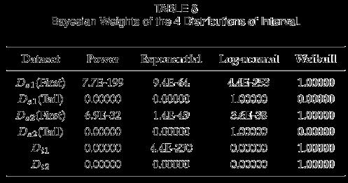
15 Part 3 Methodologies We use MLE to estimate the parameters in every distribution. Then we continue to calculate the value of BIC as follows: According to the BIC value of every distribution, we go a step further to obtain the Bayesian weights W i to determine which is the best law. 14/24
 7:00-9:00 on weekday (e) 11:00-13:00 on weekday (f) 17:00-19:00 on weekday 15/24")
16 Part 4 Experimental Results (a) 7:00-9:00 on weekend (b) 11:00-13:00 on weekend (c) 17:00-19:00 on weekend (d) 7:00-9:00 on weekday (e) 11:00-13:00 on weekday (f) 17:00-19:00 on weekday 15/24
 7:00-9:00 on weekday (e) 11:00-13:00 on weekday (f) 17:00-19:00 on weekday 16/24")
17 Part 4 Experimental Results (a) 7:00-9:00 on weekend (b) 11:00-13:00 on weekend (c) 17:00-19:00 on weekend (d) 7:00-9:00 on weekday (e) 11:00-13:00 on weekday (f) 17:00-19:00 on weekday 16/24

18 Part 4 Experimental Results Trip Displacement. 17/24


19 Part 4 Experimental Results Trip Displacement. 18/24


20 Part 4 Experimental Results Trip Duration. 26 min Subway weekend 28 min Subway weekday 8min Taxi weekend 8min Taxi weekday 19/24


21 Part 4 Experimental Results Trip Coefficient. 20/24
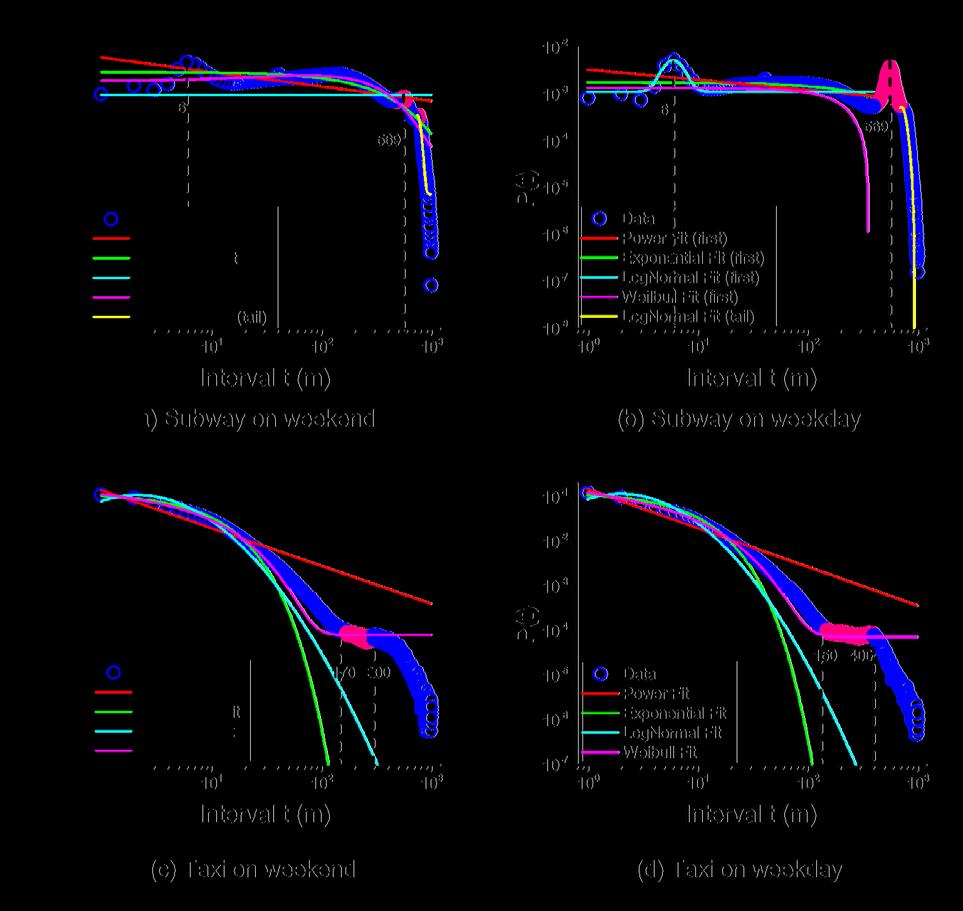
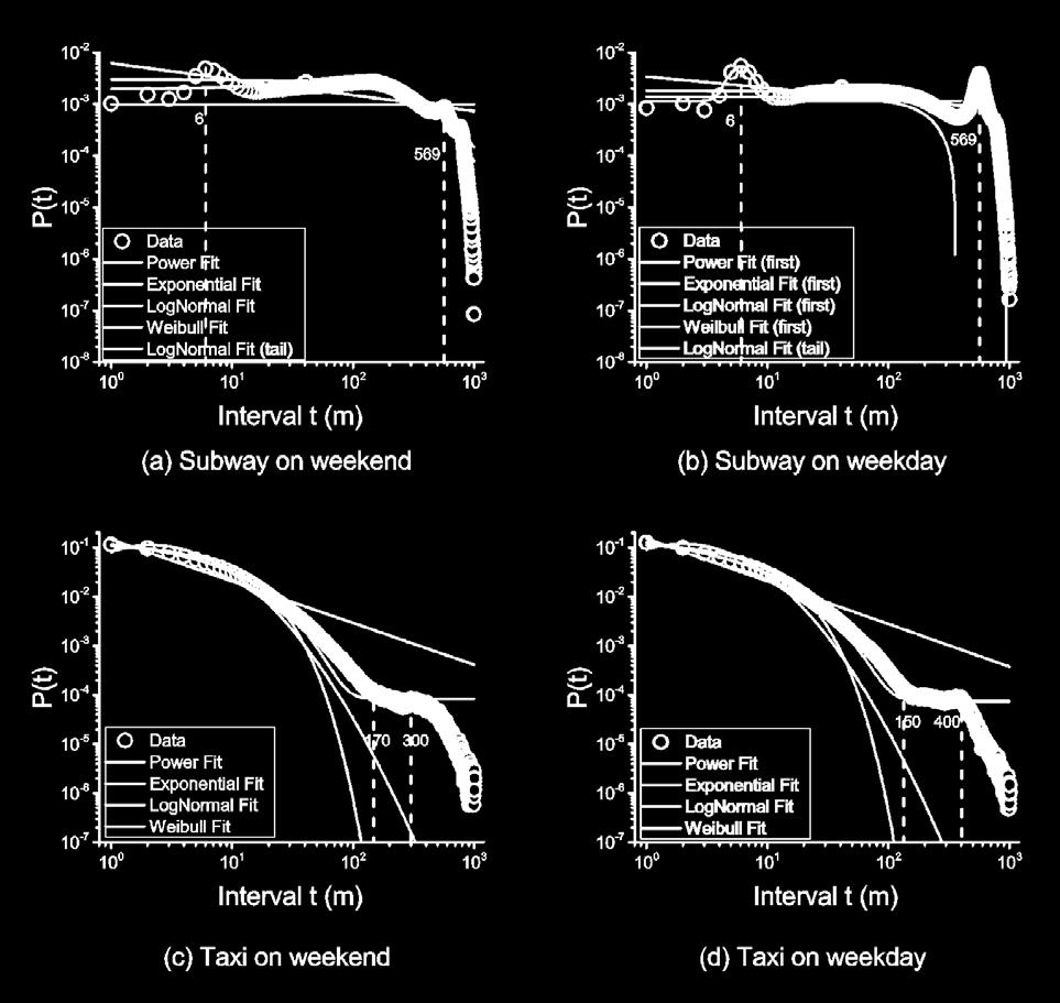

22 Part 4 Experimental Results Trip Interval. 21/24

23 Part 4 Experimental Results Trip Duration. 90% of trip interval by subway is within 580 min on weekend and 643 min on weekday respectively. In other words, folks go to another consecutive trip earlier about 1 hour on weekend than weekday, which implies that most individuals travel for social activity rather than working on weekend. 22/24

24 Part 5 Conclusion In summary, we find that human mobility patterns in Shanghai have its own characteristics differing from existing statistical results. Trip displacement is better fitted to the log-normal distribution rather than the exponential model. The Weibull distribution fits the elapsed time by subway, whereas the log-normal distribution fits the trip time by taxi. The patterns of trip interval by taxi follow the Weibull distribution, whereas there exist two-regime laws by subway which is the first part following the Weibull distribution and the tail part following the log-normal distribution. 23/24
25 THANK YOU FOR YOUR ATTENTION 24/24
Exploring Human Mobility with Multi-Source Data at Extremely Large Metropolitan Scales. ACM MobiCom 2014, Maui, HI
 Exploring Human Mobility with Multi-Source Data at Extremely Large Metropolitan Scales Desheng Zhang & Tian He University of Minnesota, USA Jun Huang, Ye Li, Fan Zhang, Chengzhong Xu Shenzhen Institute
* Abstract. Keywords: Smart Card Data, Public Transportation, Land Use, Non-negative Matrix Factorization.
 Analysis of Activity Trends Based on Smart Card Data of Public Transportation T. N. Maeda* 1, J. Mori 1, F. Toriumi 1, H. Ohashi 1 1 The University of Tokyo, 7-3-1 Hongo Bunkyo-ku, Tokyo, Japan *Email:
Detecting Origin-Destination Mobility Flows From Geotagged Tweets in Greater Los Angeles Area
 Detecting Origin-Destination Mobility Flows From Geotagged Tweets in Greater Los Angeles Area Song Gao 1, Jiue-An Yang 1,2, Bo Yan 1, Yingjie Hu 1, Krzysztof Janowicz 1, Grant McKenzie 1 1 STKO Lab, Department
VISUAL EXPLORATION OF SPATIAL-TEMPORAL TRAFFIC CONGESTION PATTERNS USING FLOATING CAR DATA. Candra Kartika 2015
 VISUAL EXPLORATION OF SPATIAL-TEMPORAL TRAFFIC CONGESTION PATTERNS USING FLOATING CAR DATA Candra Kartika 2015 OVERVIEW Motivation Background and State of The Art Test data Visualization methods Result
A route map to calibrate spatial interaction models from GPS movement data
 A route map to calibrate spatial interaction models from GPS movement data K. Sila-Nowicka 1, A.S. Fotheringham 2 1 Urban Big Data Centre School of Political and Social Sciences University of Glasgow Lilybank
Where to Find My Next Passenger?
 Where to Find My Next Passenger? Jing Yuan 1 Yu Zheng 2 Liuhang Zhang 1 Guangzhong Sun 1 1 University of Science and Technology of China 2 Microsoft Research Asia September 19, 2011 Jing Yuan et al. (USTC,MSRA)
A Probabilistic Embedding Clustering Method for Urban Structure Detection
 A Probabilistic Embedding Clustering Method for Urban Structure Detection Xin Lin a,b, Haifeng Li b*, Yan Zhang b, Lei Gao b, Ling Zhao b, Min Deng b a School of Civil Engineering, Central South University,
Urban characteristics attributable to density-driven tie formation
 Supplementary Information for Urban characteristics attributable to density-driven tie formation Wei Pan, Gourab Ghoshal, Coco Krumme, Manuel Cebrian, Alex Pentland S-1 T(ρ) 100000 10000 1000 100 theory
Spatial Data Science. Soumya K Ghosh
 Workshop on Data Science and Machine Learning (DSML 17) ISI Kolkata, March 28-31, 2017 Spatial Data Science Soumya K Ghosh Professor Department of Computer Science and Engineering Indian Institute of Technology,
Urban Computing Using Big Data to Solve Urban Challenges
 Urban Computing Using Big Data to Solve Urban Challenges Dr. Yu Zheng Lead Researcher, Microsoft Research Asia Chair Professor at Shanghai Jiaotong University http://research.microsoft.com/en-us/projects/urbancomputing/default.aspx
Exploiting Geographic Dependencies for Real Estate Appraisal
 Exploiting Geographic Dependencies for Real Estate Appraisal Yanjie Fu Joint work with Hui Xiong, Yu Zheng, Yong Ge, Zhihua Zhou, Zijun Yao Rutgers, the State University of New Jersey Microsoft Research
City monitoring with travel demand momentum vector fields: theoretical and empirical findings
 City monitoring with travel demand momentum vector fields: theoretical and empirical findings Xintao Liu 1, Joseph Y.J. Chow 2 1 Department of Civil Engineering, Ryerson University, Canada 2 Tandon School
A framework for spatio-temporal clustering from mobile phone data
 A framework for spatio-temporal clustering from mobile phone data Yihong Yuan a,b a Department of Geography, University of California, Santa Barbara, CA, 93106, USA yuan@geog.ucsb.edu Martin Raubal b b
Urban Population Migration Pattern Mining Based on Taxi Trajectories
 Urban Population Migration Pattern Mining Based on Taxi Trajectories ABSTRACT Bing Zhu Tsinghua University Beijing, China zhub.daisy@gmail.com Leonidas Guibas Stanford University Stanford, CA, U.S.A. guibas@cs.stanford.edu
Mobility Analytics through Social and Personal Data. Pierre Senellart
 Mobility Analytics through Social and Personal Data Pierre Senellart Session: Big Data & Transport Business Convention on Big Data Université Paris-Saclay, 25 novembre 2015 Analyzing Transportation and
IV Course Spring 14. Graduate Course. May 4th, Big Spatiotemporal Data Analytics & Visualization
 Spatiotemporal Data Visualization IV Course Spring 14 Graduate Course of UCAS May 4th, 2014 Outline What is spatiotemporal data? How to analyze spatiotemporal data? How to visualize spatiotemporal data?
Exploring spatial decay effect in mass media and social media: a case study of China
 Exploring spatial decay effect in mass media and social media: a case study of China 1. Introduction Yihong Yuan Department of Geography, Texas State University, San Marcos, TX, USA, 78666. Tel: +1(512)-245-3208
Discovering Urban Spatial-Temporal Structure from Human Activity Patterns
 ACM SIGKDD International Workshop on Urban Computing (UrbComp 2012) Discovering Urban Spatial-Temporal Structure from Human Activity Patterns Shan Jiang, shanjang@mit.edu Joseph Ferreira, Jr., jf@mit.edu
Modelling exploration and preferential attachment properties in individual human trajectories
 1.204 Final Project 11 December 2012 J. Cressica Brazier Modelling exploration and preferential attachment properties in individual human trajectories using the methods presented in Song, Chaoming, Tal
GIScience & Mobility. Prof. Dr. Martin Raubal. Institute of Cartography and Geoinformation SAGEO 2013 Brest, France
 GIScience & Mobility Prof. Dr. Martin Raubal Institute of Cartography and Geoinformation mraubal@ethz.ch SAGEO 2013 Brest, France 25.09.2013 1 www.woodsbagot.com 25.09.2013 2 GIScience & Mobility Modeling
IMPROVING INFRASTRUCTURE FOR TRANSPORTATION SYSTEMS USING CLUSTERING
 IMPROVING INFRASTRUCTURE FOR TRANSPORTATION SYSTEMS USING CLUSTERING Presented By: Apeksha Aggarwal Research Scholar, C.S.E. Department, IIT Roorkee Supervisor: Dr. Durga Toshniwal Associate Professor,
Exploring Urban Mobility from Taxi Trajectories: A Case Study of Nanjing, China
 Exploring Urban Mobility from Taxi Trajectories: A Case Study of Nanjing, China Yihong Yuan and Maël Le Noc Department of Geography, Texas State University, San Marcos, TX, U.S.A. {yuan, mael.lenoc}@txstate.edu
Mobility Pattern of Taxi Passengers at Intra-Urban Scale: Empirical Study of Three Cities
 Journal of Systems Science and Information Dec., 2017, Vol. 5, No. 6, pp. 537 555 DOI: 10.21078/JSSI-2017-537-19 Mobility Pattern of Taxi Passengers at Intra-Urban Scale: Empirical Study of Three Cities
Encapsulating Urban Traffic Rhythms into Road Networks
 Encapsulating Urban Traffic Rhythms into Road Networks Junjie Wang +, Dong Wei +, Kun He, Hang Gong, Pu Wang * School of Traffic and Transportation Engineering, Central South University, Changsha, Hunan,
Exploring Urban Mobility from Taxi Trajectories: A Case Study of Nanjing, China
 Exploring Urban Mobility from Taxi Trajectories: A Case Study of Nanjing, China Yihong Yuan, Maël Le Noc Department of Geography, Texas State University,San Marcos, TX, USA {yuan, mael.lenoc}@ txstate.edu
Activity Identification from GPS Trajectories Using Spatial Temporal POIs Attractiveness
 Activity Identification from GPS Trajectories Using Spatial Temporal POIs Attractiveness Lian Huang, Qingquan Li, Yang Yue State Key Laboratory of Information Engineering in Survey, Mapping and Remote
LABELING RESIDENTIAL COMMUNITY CHARACTERISTICS FROM COLLECTIVE ACTIVITY PATTERNS USING TAXI TRIP DATA
 LABELING RESIDENTIAL COMMUNITY CHARACTERISTICS FROM COLLECTIVE ACTIVITY PATTERNS USING TAXI TRIP DATA Yang Zhou 1, 3, *, Zhixiang Fang 2 1 Wuhan Land Use and Urban Spatial Planning Research Center, 55Sanyang
SPATIO-TEMPORAL PATTERN MINING ON TRAJECTORY DATA USING ARM
 SPATIO-TEMPORAL PATTERN MINING ON TRAJECTORY DATA USING ARM S. Khoshahval a *, M. Farnaghi a, M. Taleai a a Faculty of Geodesy and Geomatics Engineering, K.N. Toosi University of Technology, Tehran, Iran
Construction and Analysis of Climate Networks
 Construction and Analysis of Climate Networks Karsten Steinhaeuser University of Minnesota Workshop on Understanding Climate Change from Data Minneapolis, MN August 15, 2011 Working Definitions Knowledge
Validating general human mobility patterns on massive GPS data
 Validating general human mobility patterns on massive GPS data Luca Pappalardo, Salvatore Rinzivillo, Dino Pedreschi, and Fosca Giannotti KDDLab, Institute of Information Science and Technologies (ISTI),
Bus Landscapes: Analyzing Commuting Pattern using Bus Smart Card Data in Beijing
 Bus Landscapes: Analyzing Commuting Pattern using Bus Smart Card Data in Beijing Ying Long, Beijing Institute of City Planning 龙瀛 Jean-Claude Thill, The University of North Carolina at Charlotte 1 INTRODUCTION
Minimum message length estimation of mixtures of multivariate Gaussian and von Mises-Fisher distributions
 Minimum message length estimation of mixtures of multivariate Gaussian and von Mises-Fisher distributions Parthan Kasarapu & Lloyd Allison Monash University, Australia September 8, 25 Parthan Kasarapu
Inferring Friendship from Check-in Data of Location-Based Social Networks
 Inferring Friendship from Check-in Data of Location-Based Social Networks Ran Cheng, Jun Pang, Yang Zhang Interdisciplinary Centre for Security, Reliability and Trust, University of Luxembourg, Luxembourg
Latent spatio-temporal activity structures: a new approach to inferring intra-urban functional regions via social media check-in data
 Geo-spatial Information Science ISSN: 1009-5020 (Print) 1993-5153 (Online) Journal homepage: https://www.tandfonline.com/loi/tgsi20 Latent spatio-temporal activity structures: a new approach to inferring
A Cloud Computing Workflow for Scalable Integration of Remote Sensing and Social Media Data in Urban Studies
 A Cloud Computing Workflow for Scalable Integration of Remote Sensing and Social Media Data in Urban Studies Aiman Soliman1, Kiumars Soltani1, Junjun Yin1, Balaji Subramaniam2, Pierre Riteau2, Kate Keahey2,
Analysis of the urban travel structure using smartcard and GPS data from Santiago, Chile
 Analysis of the urban travel structure using smartcard and GPS data from Santiago, Chile Marcela Munizaga, Felipe Hernández, Universidad de Chile Ricardo Hurtubia, Pontificia Universidad Católica de Chile
MobiSeg: Interactive Region Segmentation Using Heterogeneous Mobility Data
 MobiSeg: Interactive Region Segmentation Using Heterogeneous Mobility Data Wenchao Wu, Yixian Zheng Nan Cao Hong Kong University of Tongji University Haipeng Zeng, Bing Ni, Huamin Qu Lionel M. Ni Hong
Sensing Urban Density using Mobile Phone GPS Locations: A case study of Odaiba area, Japan
 Sensing Urban Density using Mobile Phone GPS Locations: A case study of Odaiba area, Japan Teerayut Horanont 1,2,*, Santi Phithakkitnukoon 3,*, Ryosuke Shibasaki 1 1 Department of Civil Engineering, The
Incorporating Spatio-Temporal Smoothness for Air Quality Inference
 2017 IEEE International Conference on Data Mining Incorporating Spatio-Temporal Smoothness for Air Quality Inference Xiangyu Zhao 2, Tong Xu 1, Yanjie Fu 3, Enhong Chen 1, Hao Guo 1 1 Anhui Province Key
arxiv: v3 [physics.soc-ph] 2 Feb 2015
![arxiv: v3 [physics.soc-ph] 2 Feb 2015](/thumbs/73/68895685.jpg "arxiv: v3 [physics.soc-ph] 2 Feb 2015") Explaining the power-law distribution of human mobility through transportation modality decomposition Kai Zhao, 1, Mirco Musolesi, 2 Pan Hui, 3 Weixiong Rao, 4 and Sasu Tarkoma 1, 1 Department of Computer
Explaining the power-law distribution of human mobility through transportation modality decomposition Kai Zhao, 1, Mirco Musolesi, 2 Pan Hui, 3 Weixiong Rao, 4 and Sasu Tarkoma 1, 1 Department of Computer
A Geo-Statistical Approach for Crime hot spot Prediction
 A Geo-Statistical Approach for Crime hot spot Prediction Sumanta Das 1 Malini Roy Choudhury 2 Abstract Crime hot spot prediction is a challenging task in present time. Effective models are needed which
Measurement of human activity using velocity GPS data obtained from mobile phones
 Measurement of human activity using velocity GPS data obtained from mobile phones Yasuko Kawahata 1 Takayuki Mizuno 2 and Akira Ishii 3 1 Graduate School of Information Science and Technology, The University
Travel Pattern Recognition using Smart Card Data in Public Transit
 International Journal of Emerging Engineering Research and Technology Volume 4, Issue 7, July 2016, PP 6-13 ISSN 2349-4395 (Print) & ISSN 2349-4409 (Online) Travel Pattern Recognition using Smart Card
A Location Predictor based on Dependencies Between Multiple Lifelog Data
 A Location Predictor based on Dependencies Between Multiple Lifelog Data Masaaki Nishino Takashi Yagi Yukihiro Nakamura Shinyo Muto NTT Cyber Solutions Laboratories, NTT Corporation Masanobu Abe Graduate
Data Mining II Mobility Data Mining
 Data Mining II Mobility Data Mining F. Giannotti& M. Nanni KDD Lab ISTI CNR Pisa, Italy Outline Mobility Data Mining Introduction MDM methods MDM methods at work. Understanding Human Mobility Clustering
Classification in Mobility Data Mining
 Classification in Mobility Data Mining Activity Recognition Semantic Enrichment Recognition through Points-of-Interest Given a dataset of GPS tracks of private vehicles, we annotate trajectories with the
Clustering Analysis of London Police Foot Patrol Behaviour from Raw Trajectories
 Clustering Analysis of London Police Foot Patrol Behaviour from Raw Trajectories Jianan Shen 1, Tao Cheng 2 1 SpaceTimeLab for Big Data Analytics, Department of Civil, Environmental and Geomatic Engineering,
Understanding taxi travel demand patterns through Floating Car Data Nuzzolo, A., Comi, A., Papa, E. and Polimeni, A.
 WestminsterResearch http://www.westminster.ac.uk/westminsterresearch Understanding taxi travel demand patterns through Floating Car Data Nuzzolo, A., Comi, A., Papa, E. and Polimeni, A. A paper presented
Social and Technological Network Analysis: Spatial Networks, Mobility and Applications
 Social and Technological Network Analysis: Spatial Networks, Mobility and Applications Anastasios Noulas Computer Laboratory, University of Cambridge February 2015 Today s Outline 1. Introduction to spatial
Spatial Data, Spatial Analysis and Spatial Data Science
 Spatial Data, Spatial Analysis and Spatial Data Science Luc Anselin http://spatial.uchicago.edu 1 spatial thinking in the social sciences spatial analysis spatial data science spatial data types and research
Diagnosing New York City s Noises with Ubiquitous Data
 Diagnosing New York City s Noises with Ubiquitous Data Dr. Yu Zheng yuzheng@microsoft.com Lead Researcher, Microsoft Research Chair Professor at Shanghai Jiao Tong University Background Many cities suffer
Research Article Urban Mobility Dynamics Based on Flexible Discrete Region Partition
 International Journal of Distributed Sensor Networks, Article ID 782649, 1 pages http://dx.doi.org/1.1155/214/782649 Research Article Urban Mobility Dynamics Based on Flexible Discrete Region Partition
Social and Technological Network Analysis. Lecture 11: Spa;al and Social Network Analysis. Dr. Cecilia Mascolo
 Social and Technological Network Analysis Lecture 11: Spa;al and Social Network Analysis Dr. Cecilia Mascolo In This Lecture In this lecture we will study spa;al networks and geo- social networks through
A Computational Movement Analysis Framework For Exploring Anonymity In Human Mobility Trajectories
 A Computational Movement Analysis Framework For Exploring Anonymity In Human Mobility Trajectories Jennifer A. Miller 2015 UT CID Report #1512 This UT CID research was supported in part by the following
Urban Link Travel Time Estimation Using Large-scale Taxi Data with Partial Information
 Urban Link Travel Time Estimation Using Large-scale Taxi Data with Partial Information * Satish V. Ukkusuri * * Civil Engineering, Purdue University 24/04/2014 Outline Introduction Study Region Link Travel
A Machine Learning Approach to Trip Purpose Imputation in GPS-Based Travel Surveys
 A Machine Learning Approach to Trip Purpose Imputation in GPS-Based Travel Surveys Yijing Lu 1, Shanjiang Zhu 2, and Lei Zhang 3,* 1. Graduate Research Assistant 2. Research Scientist 2. Assistant Professor
Caesar s Taxi Prediction Services
 1 Caesar s Taxi Prediction Services Predicting NYC Taxi Fares, Trip Distance, and Activity Paul Jolly, Boxiao Pan, Varun Nambiar Abstract In this paper, we propose three models each predicting either taxi
Driving Restriction, Traffic Congestion, and Air Pollution: Evidence from Beijing
 Driving Restriction, Traffic Congestion, and Air Pollution: Evidence from Beijing Chen Liu Junjie Zhang UC San Diego Camp Resources XXI August 10-12, 2014 Traffic Congestion and Air Pollution 1 Motivation
Friendship and Mobility: User Movement In Location-Based Social Networks. Eunjoon Cho* Seth A. Myers* Jure Leskovec
 Friendship and Mobility: User Movement In Location-Based Social Networks Eunjoon Cho* Seth A. Myers* Jure Leskovec Outline Introduction Related Work Data Observations from Data Model of Human Mobility
Urban Attractors: Discovering Patterns in Regions of Attraction in Cities. Abstract. Introduction
 Urban Attractors: Discovering Patterns in Regions of Attraction in Cities May Alhazzani 1, Fahad Alhasoun 2, Zeyad Alawwad 1, Marta C. González 2,3, 1 Center for Complex Engineering Systems, King Abdulaziz
Regularity and Conformity: Location Prediction Using Heterogeneous Mobility Data
 Regularity and Conformity: Location Prediction Using Heterogeneous Mobility Data Yingzi Wang 12, Nicholas Jing Yuan 2, Defu Lian 3, Linli Xu 1 Xing Xie 2, Enhong Chen 1, Yong Rui 2 1 University of Science
Supplementary Figures
 Supplementary Figures 10 1 Roma Milano Napoli Torino Palermo Genova 0.3 0.25 (a) P(t) 10 1 (b) t (h) 0.2 0 0.2 0.4 0.6 0.8 1 t (h) 0.15 10 4 10 5 10 6 10 7 Population Supplementary Figure 1: Variation
Time Series Data Cleaning
 Time Series Data Cleaning Shaoxu Song http://ise.thss.tsinghua.edu.cn/sxsong/ Dirty Time Series Data Unreliable Readings Sensor monitoring GPS trajectory J. Freire, A. Bessa, F. Chirigati, H. T. Vo, K.
Modeling Crowd Flows Network to Infer Origins and Destinations of Crowds from Cellular Data
 Modeling Crowd Flows Network to Infer Origins and Destinations of Crowds from Cellular Data Ai-Jou Chou ajchou@cs.nctu.edu.tw Gunarto Sindoro Njoo gunarto.cs01g@g2.nctu.edu.tw Wen-Chih Peng wcpeng@cs.nctu.edu.tw
Unobserved Heterogeneity and the Statistical Analysis of Highway Accident Data. Fred Mannering University of South Florida
 Unobserved Heterogeneity and the Statistical Analysis of Highway Accident Data Fred Mannering University of South Florida Highway Accidents Cost the lives of 1.25 million people per year Leading cause
Not All Apps Are Created Equal:
 Not All Apps Are Created Equal: Analysis of Spatiotemporal Heterogeneity in Nationwide Mobile Service Usage Cristina Marquez and Marco Gramaglia (Universidad Carlos III de Madrid); Marco Fiore (CNR-IEIIT);
Perspectives on Stability and Mobility of Passenger s Travel Behavior through Smart Card Data
 Perspectives on Stability and Mobility of Passenger s Travel Behavior through Smart Card Data Zhiyong Cui Peking University Beijing, China 111546@pku.edu.cn Ying Long Beijing Institute of City Planning
Extracting Patterns of Individual Movement Behaviour from a Massive Collection of Tracked Positions
 Extracting Patterns of Individual Movement Behaviour from a Massive Collection of Tracked Positions Gennady Andrienko and Natalia Andrienko Fraunhofer Institute IAIS Schloss Birlinghoven, 53754 Sankt Augustin,
Estimating Large Scale Population Movement ML Dublin Meetup
 Deutsche Bank COO Chief Data Office Estimating Large Scale Population Movement ML Dublin Meetup John Doyle PhD Assistant Vice President CDO Research & Development Science & Innovation john.doyle@db.com
Spatial Extension of the Reality Mining Dataset
 R&D Centre for Mobile Applications Czech Technical University in Prague Spatial Extension of the Reality Mining Dataset Michal Ficek, Lukas Kencl sponsored by Mobility-Related Applications Wanted! Urban
A Survey on Trajectory Data Mining: Techniques and Applications
 SPECIAL SECTION ON THEORETICAL FOUNDATIONS FOR BIG DATA APPLICATIONS: CHALLENGES AND OPPORTUNITIES Received February 29, 2016, accepted March 27, 2016, date of publication April 13, 2016, date of current
Measuring Social Functions of City Regions from Large-scale Taxi Behaviors
 Work in Progress workshop at PerCom 2 Measuring Social Functions of City Regions from Large-scale Taxi Behaviors Guande Qi, Xiaolong Li, Shijian Li, Gang Pan and Zonghui Wang Department of Computer Science
Models to carry out inference vs. Models to mimic (spatio-temporal) systems 5/5/15
 systems 5/5/15") Models to carry out inference vs. Models to mimic (spatio-temporal) systems 5/5/15 Ring-Shaped Hotspot Detection: A Summary of Results, IEEE ICDM 2014 (w/ E. Eftelioglu et al.) Where is a crime source?
Models to carry out inference vs. Models to mimic (spatio-temporal) systems 5/5/15 Ring-Shaped Hotspot Detection: A Summary of Results, IEEE ICDM 2014 (w/ E. Eftelioglu et al.) Where is a crime source?
Visualisation of Spatial Data
 Visualisation of Spatial Data VU Visual Data Science Johanna Schmidt WS 2018/19 2 Visual Data Science Introduction to Visualisation Basics of Information Visualisation Charts and Techniques Introduction
NEIGHBOURHOOD DETECTION WITH ANALYTICAL TOOLS
 S. Chien, S. Choo, M. A. Schnabel, W. Nakapan, M. J. Kim, S. Roudavski (eds.), Living Systems and Micro-Utopias: Towards Continuous Designing, Proceedings of the 21st International Conference of the Association
Texas A&M University
 Texas A&M University CVEN 658 Civil Engineering Applications of GIS Hotspot Analysis of Highway Accident Spatial Pattern Based on Network Spatial Weights Instructor: Dr. Francisco Olivera Author: Zachry
ECE521 Tutorial 11. Topic Review. ECE521 Winter Credits to Alireza Makhzani, Alex Schwing, Rich Zemel and TAs for slides. ECE521 Tutorial 11 / 4
 ECE52 Tutorial Topic Review ECE52 Winter 206 Credits to Alireza Makhzani, Alex Schwing, Rich Zemel and TAs for slides ECE52 Tutorial ECE52 Winter 206 Credits to Alireza / 4 Outline K-means, PCA 2 Bayesian
Research Seminar on Urban Information Systems
 11.522 Research Seminar on Urban Information Systems Instructor: Joe Ferreira, jf@mit.edu Monday, 6-8 PM in Room 9-451 Opportunity for students to build on basic skills in GIS and urban analytics in order
Supporting Statistical Hypothesis Testing Over Graphs
 Supporting Statistical Hypothesis Testing Over Graphs Jennifer Neville Departments of Computer Science and Statistics Purdue University (joint work with Tina Eliassi-Rad, Brian Gallagher, Sergey Kirshner,
Spatial-Temporal Analytics with Students Data to recommend optimum regions to stay
 Spatial-Temporal Analytics with Students Data to recommend optimum regions to stay By ARUN KUMAR BALASUBRAMANIAN (A0163264H) DEVI VIJAYAKUMAR (A0163403R) RAGHU ADITYA (A0163260N) SHARVINA PAWASKAR (A0163302W)
Probabilistic Graphical Models
 Probabilistic Graphical Models Lecture 12 Dynamical Models CS/CNS/EE 155 Andreas Krause Homework 3 out tonight Start early!! Announcements Project milestones due today Please email to TAs 2 Parameter learning
Big Data Analysis to Measure Delays of Canadian Domestic and Cross-Border Truck Trips
 Big Data Analysis to Measure Delays of Canadian Domestic and Cross-Border Truck Trips Kevin Gingerich and Hanna Maoh University of Windsor Freight Day VI Symposium Hosted by the University of Toronto Transportation
Discovering Geographical Topics in Twitter
 Discovering Geographical Topics in Twitter Liangjie Hong, Lehigh University Amr Ahmed, Yahoo! Research Alexander J. Smola, Yahoo! Research Siva Gurumurthy, Twitter Kostas Tsioutsiouliklis, Twitter Overview
Brief Introduction of Machine Learning Techniques for Content Analysis
 1 Brief Introduction of Machine Learning Techniques for Content Analysis Wei-Ta Chu 2008/11/20 Outline 2 Overview Gaussian Mixture Model (GMM) Hidden Markov Model (HMM) Support Vector Machine (SVM) Overview
Using Open Data to Analyze Urban Mobility from Social Networks
 Using Open Data to Analyze Urban Mobility from Social Networks Caio Libânio Melo Jerônimo, Claudio E. C. Campelo, Cláudio de Souza Baptista Federal University of Campina Grande, Brazil caiolibanio@copin.ufcg.edu.br,{campelo,baptista}@computacao.ufcg.edu.br
Trip Distribution Modeling Milos N. Mladenovic Assistant Professor Department of Built Environment
 Trip Distribution Modeling Milos N. Mladenovic Assistant Professor Department of Built Environment 25.04.2017 Course Outline Forecasting overview and data management Trip generation modeling Trip distribution
Bayesian Hierarchical Models
 Bayesian Hierarchical Models Gavin Shaddick, Millie Green, Matthew Thomas University of Bath 6 th - 9 th December 2016 1/ 34 APPLICATIONS OF BAYESIAN HIERARCHICAL MODELS 2/ 34 OUTLINE Spatial epidemiology
1. INTRODUCTION 2. BIG DATA IN URBAN STUDIES 3. LESSONS FROM BIG DATA
 Main Content URBAN SENSING & COMPUTING Sensing and Computing Introduction and Application 王江浩 State Key Laboratory of Resources and Environmental Information System, Institute of Geographic Sciences and
Research on Patterns Mining Method for Moving Objects
 , pp.200-205 http://dx.doi.org/10.14257/astl.2016.123.37 Research on Patterns Mining Method for Moving Objects Li Chen 1, Lianggui Liu 1, Bingxian Chen 1, Huiling Jia 1, 1 School of Information Science
Quantifying Demand Dynamics for Supporting Optimal Taxi Services Strategies
 Available online at www.sciencedirect.com ScienceDirect Transportation Research Procedia 22 (2017) 675 684 www.elsevier.com/locate/procedia 19th EURO Working Group on Transportation Meeting, EWGT2016,
Urban Computing Using Big Data to Solve Urban Challenges
 Urban Computing Using Big Data to Solve Urban Challenges Dr. Yu Zheng Lead Researcher, Microsoft Research Chair Professor at Shanghai Jiao Tong University http://research.microsoft.com/en-us/projects/urbancomputing/default.aspx
Smart Route Recommendations based on Historical GPS Trajectories and Weather Information
 Smart Route Recommendations based on Historical GPS Trajectories and Weather Information Xingzhe Xie1, Kevin Wong2, Hamid Aghajan2 and Wilfried Philips1 1 TELIN IPI iminds, Ghent University, Belgium 2
Probabilistic Graphical Models
 Probabilistic Graphical Models Lecture 5 Bayesian Learning of Bayesian Networks CS/CNS/EE 155 Andreas Krause Announcements Recitations: Every Tuesday 4-5:30 in 243 Annenberg Homework 1 out. Due in class
Extracting mobility behavior from cell phone data DATA SIM Summer School 2013
 Extracting mobility behavior from cell phone data DATA SIM Summer School 2013 PETER WIDHALM Mobility Department Dynamic Transportation Systems T +43(0) 50550-6655 F +43(0) 50550-6439 peter.widhalm@ait.ac.at
An Introduction to Reversible Jump MCMC for Bayesian Networks, with Application
 An Introduction to Reversible Jump MCMC for Bayesian Networks, with Application, CleverSet, Inc. STARMAP/DAMARS Conference Page 1 The research described in this presentation has been funded by the U.S.
Believe it Today or Tomorrow? Detecting Untrustworthy Information from Dynamic Multi-Source Data
 SDM 15 Vancouver, CAN Believe it Today or Tomorrow? Detecting Untrustworthy Information from Dynamic Multi-Source Data Houping Xiao 1, Yaliang Li 1, Jing Gao 1, Fei Wang 2, Liang Ge 3, Wei Fan 4, Long
UnSAID: Uncertainty and Structure in the Access to Intensional Data
 UnSAID: Uncertainty and Structure in the Access to Intensional Data Pierre Senellart 3 July 214, Univ. Rennes 1 Uncertain data is everywhere Numerous sources of uncertain data: Measurement errors Data
Correlations and Scaling Laws in Human Mobility
 Xiang-Wen Wang 1,2,3, Xiao-Pu Han 1 *, Bing-Hong Wang 3,4,5 1 Alibaba Research Center for Complexity Sciences, Hangzhou Normal University, Hangzhou, China, 2 Department of Physics, Virginia Polytechnic
Exploring Human Mobility with Multi-Source Data at Extremely Large Metropolitan Scales
 Exploring Human Mobility with Multi-Source Data at Extremely Large Metropolitan Scales Desheng Zhang zhang@cs.umn.edu Fan Zhang zhangfan@siat.ac.cn Jun Huang jun.huang@siat.ac.cn Chengzhong Xu cz.xu@siat.ac.cn
LAND USE CLASSIFICATION FROM COMBINED USE OF REMOTE SENSING AND SOCIAL SENSING DATA
 LAND USE CLASSIFICATION FROM COMBINED USE OF REMOTE SENSING AND SOCIAL SENSING DATA Adindha Surya Anugraha 1, Hone-Jay Chu 1 * 1 Dept. of Geomatics, National Cheng Kung University, Taiwan adindha.surya@gmail.com,