Estimating Large Scale Population Movement ML Dublin Meetup
|
|
|
- Randolf Parsons
- 5 years ago
- Views:
Transcription

1 Deutsche Bank COO Chief Data Office Estimating Large Scale Population Movement ML Dublin Meetup John Doyle PhD Assistant Vice President CDO Research & Development Science & Innovation


2 Estimating Large Scale Population Movement Presentation Outline Introduction: Research Motivation & Data Mobility: Trajectories & Large Scale Movement Population: Density Estimates Application: How to Use the Data Conclusions: Summary of the Research Deutsche Bank COO - Chief Data Ofce 2
3 Research Motivation Measuring the movement of people is a fundamental activity in modern society Movement data is used by: Transportation services Planning authorities Governmental departments It is also the primary data source used in the delivery of mobile communications and location based services This research documents novel algorithms and techniques for the estimation of movement from mobile telephony data addressing practical issues related to sampling, privacy and spatial uncertainty. Deutsche Bank COO - Chief Data Ofce 3
 CDR is a")


4 Mobile Telephony Data Call Detail Records (CDR) CDR is a data log of recorded Call, SMS and data activities which occur on a mobile operator s telephony network. Deutsche Bank COO - Chief Data Ofce Approximately 1 million customers generating over 1.5 billion records BS1 BS2 U1 Mobile Operator CDR Collection Server U2 4


5 CDR Data Mining Deutsche Bank COO - Chief Data Ofce CDR Spatiotemporal Data Types Trajectory Information User Social / Cell Network Cell Activities 5

6

7 Subscriber Trajectories Trajectories from CDR only capture cell locations of individuals when they record mobile phone activity

8 Trajectory Issues Spatial Resolution Sampling rate V is ibile P roportion of P opulation User activity follow a burst mentality Location estimates are fixed to cell tower coverage areas Voronoi cells :00 08:00 12;00 Time 16:00 20:00 24:00
9 Scaling Cells to Regions Cell Coverage x 10 Spatial Regions of Interest 5 5 x Northing Northing Easting cells x Easting regions x 10 5
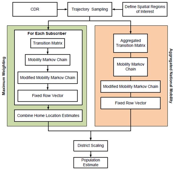
10 Uniform Sampling Within each 15-minute temporal window, the estimate of location is based on the last recorded servicing cell tower recorded for that subscriber during that period. CDR trajectory state sequence sampling of the output sequence S = {S1, S1, S3, S3, S4}. Smaller yellow circles represent actual regional transitions within a sample period and larger yellow circles represent the observed output transition sequence before resampling.
11 Regional Flows of Subscribers By observing the flow of people between clustered regions and the geographical areas covered, a proxy for the flow of people between individual population centres can be established. These results can summarised in an aggregated transition matrix T(k),

12 Average Intensity of Subscribers Between Regions

13 Temporal Flow of Subscribers
14 Population Estimation A census is the primary tool used by national governments to gather information on population metrics, which includes among others population count, religious status, material status and household occupancy. The knowledge obtained dictates future policy on decisions related to the planning of future infrastructure and public services. While the information gathered is extremely important for the delivery of such services, the cost of carrying out a census is prohibitively expensive. As a result a census may be only carried out every 5-10 years. Consequently, they provide poor temporal resolution and are incapable of providing information on the current status of a population. This motivates the requirement for low cost alternatives.
15
16 Modelling User Movement We can model individual user movement with Markov chains. Homogeneous Markov chains are useful when the state sequence, S(k), k = 0; 1; 2;..., is directly observable. By extracting a subscriber CDR trajectory, it is possible to directly observe an individual subscriber s cell tower state sequence. Markov chains may be used to model a mobile subscribers transient movement between the symbolic locations represented by the clustered cell regions.
17 Subscriber Regions of Interest If a Markov chains is ergodic where W is a matrix with identical rows w, and all components of w sum to 1. The fixed row vector, w, of a mobile subscriber s mobility Markov chain conveys the probability of observing that subscriber at a region in space over a long period of time. As not all mobility Markov chains are ergodic, introduce a regularisation weight where Q is a modified Markov chain, R is the number of states, J is a R x R matrix of ones and α balances the learnt mobility patterns summarised by P with the influence of random transition probabilities introduced by the term J/R


18 The Q of a randomly select subscriber Low transition probabilities are not illustrated for visual clarity The observed regional ranking suggests that the subscriber tends to travel in County Meath, with occasional trips into Dublin City
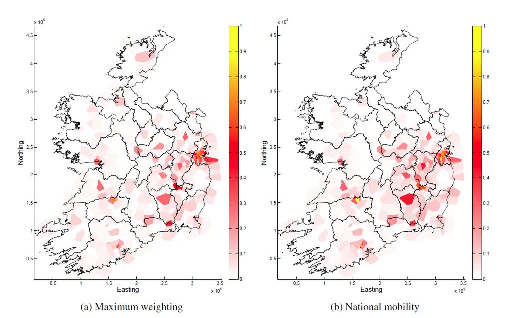
19 Population Density

20 ED Population Corr 86.61% Corr 84.38%
21 Population Estimation The correlation between census data and maximum weighting approach is approximately 98.4%. The correlation between census data and aggregated approach is approximately 97.7%. However, as performance is restricted by its ability to measure population proportions in different areas, but not the ability to estimate counts, the effectiveness of such techniques for inferring census type data needs further research and is the subject of future work.
22 Application Areas Mobile network operators are beginning to see profit margins fall due to tighter regulation increasing demand for data services falling revenues generated from call and SMS traffic In this context, network operators are increasingly focusing their efforts on new revenues generation schemes lower subscriber churn increasing customer satisfaction rates However, this shift in focus has unearthed significant gaps in their knowledge of how subscribers use and perceive the mobile services on offer to them.

 road and (b)")
23 Transportation Planning Kernel density estimate of journey trajectories identified as travelling along (a) road and (b) rail travel paths.

24 High Mobile Traffic Regions Of Interest Combine the vector weights of high data usage subscribers Better understanding of the areas they occupy on a daily basis Design more efficient networks Identify coverage black spots Better data for marketing
25 Identify Event Mobility

26 Geographically Weighted Amenities
27 Catchment Area
28 Acknowledgements This research was funded by a Strategic Research Cluster grant (07/SRC/I1168) by Science Foundation Ireland under the National Development Plan and by the Irish Research Council under their Embark Initiative in partnership with ESRI Ireland. I would also like to gratefully acknowledge the support of Meteor for providing the data used in this research, in particular John Bathe and Adrian Whitwham.
29 Questions?
Encapsulating Urban Traffic Rhythms into Road Networks
 Encapsulating Urban Traffic Rhythms into Road Networks Junjie Wang +, Dong Wei +, Kun He, Hang Gong, Pu Wang * School of Traffic and Transportation Engineering, Central South University, Changsha, Hunan,
Methodological issues in the development of accessibility measures to services: challenges and possible solutions in the Canadian context
 Methodological issues in the development of accessibility measures to services: challenges and possible solutions in the Canadian context Alessandro Alasia 1, Frédéric Bédard 2, and Julie Bélanger 1 (1)
SPATIAL INEQUALITIES IN PUBLIC TRANSPORT AVAILABILITY: INVESTIGATION WITH SMALL-AREA METRICS
 SPATIAL INEQUALITIES IN PUBLIC TRANSPORT AVAILABILITY: INVESTIGATION WITH SMALL-AREA METRICS Research conducted by Yeran Sun and Piyushimita (Vonu) Thakuriah Presented by Obinna C.D. Anejionu INTRODUCTION
GIS Spatial Statistics for Public Opinion Survey Response Rates
 GIS Spatial Statistics for Public Opinion Survey Response Rates July 22, 2015 Timothy Michalowski Senior Statistical GIS Analyst Abt SRBI - New York, NY t.michalowski@srbi.com www.srbi.com Introduction
A Comprehensive Method for Identifying Optimal Areas for Supermarket Development. TRF Policy Solutions April 28, 2011
 A Comprehensive Method for Identifying Optimal Areas for Supermarket Development TRF Policy Solutions April 28, 2011 Profile of TRF The Reinvestment Fund builds wealth and opportunity for lowwealth communities
Typical information required from the data collection can be grouped into four categories, enumerated as below.
 Chapter 6 Data Collection 6.1 Overview The four-stage modeling, an important tool for forecasting future demand and performance of a transportation system, was developed for evaluating large-scale infrastructure
Detecting Origin-Destination Mobility Flows From Geotagged Tweets in Greater Los Angeles Area
 Detecting Origin-Destination Mobility Flows From Geotagged Tweets in Greater Los Angeles Area Song Gao 1, Jiue-An Yang 1,2, Bo Yan 1, Yingjie Hu 1, Krzysztof Janowicz 1, Grant McKenzie 1 1 STKO Lab, Department
Spatial Variation in Local Road Pedestrian and Bicycle Crashes
 2015 Esri International User Conference July 20 24, 2015 San Diego, California Spatial Variation in Local Road Pedestrian and Bicycle Crashes Musinguzi, Abram, Graduate Research Assistant Chimba,Deo, PhD.,
Using Innovative Data in Transportation Planning and Modeling
 Using Innovative Data in Transportation Planning and Modeling presented at 2014 Ground Transportation Technology Symposium: Big Data and Innovative Solutions for Safe, Efficient, and Sustainable Mobility
Crime Analysis. GIS Solutions for Intelligence-Led Policing
 Crime Analysis GIS Solutions for Intelligence-Led Policing Applying GIS Technology to Crime Analysis Know Your Community Analyze Your Crime Use Your Advantage GIS aids crime analysis by Identifying and
Foreword. Vision and Strategy
 GREATER MANCHESTER SPATIAL FRAMEWORK Friends of Walkden Station Consultation Response January 2017 Foreword Friends of Walkden Station are a group of dedicated volunteers seeking to raise the status and
Changes in the Spatial Distribution of Mobile Source Emissions due to the Interactions between Land-use and Regional Transportation Systems
 Changes in the Spatial Distribution of Mobile Source Emissions due to the Interactions between Land-use and Regional Transportation Systems A Framework for Analysis Urban Transportation Center University
Geomarketing as a Marketing Planning Tool. ESRI International User Conference San Diego, June 2007
 Geomarketing as a Marketing Planning Tool ESRI International User Conference San Diego, June 2007 25 Bruno e 26 de Marsili Janeiro de 2006 0 Abstract Telecom Italia Mobile (TIM) is a major wireless operator
Egypt Public DSS. the right of access to information. Mohamed Ramadan, Ph.D. [R&D Advisor to the president of CAPMAS]
![Egypt Public DSS. the right of access to information. Mohamed Ramadan, Ph.D. [R&D Advisor to the president of CAPMAS]](/thumbs/89/98483713.jpg "Egypt Public DSS. the right of access to information. Mohamed Ramadan, Ph.D. [R&D Advisor to the president of CAPMAS]") Egypt Public DSS ì the right of access to information Central Agency for Public Mobilization and Statistics Arab Republic of Egypt Mohamed Ramadan, Ph.D. [R&D Advisor to the president of CAPMAS] Egypt
Egypt Public DSS ì the right of access to information Central Agency for Public Mobilization and Statistics Arab Republic of Egypt Mohamed Ramadan, Ph.D. [R&D Advisor to the president of CAPMAS] Egypt
Designing smart & Resilient cities:
 Designing smart & Resilient cities: How can Egyptian cities learn from an emerging global practice On the Cuspof Change Professor Samer Bagaeen FRICS MRTPI FRSA AoU 1. GLOBAL CHALLENGES POPULATION GROWTH,
transportation research in policy making for addressing mobility problems, infrastructure and functionality issues in urban areas. This study explored
 ABSTRACT: Demand supply system are the three core clusters of transportation research in policy making for addressing mobility problems, infrastructure and functionality issues in urban areas. This study
Data Collection. Lecture Notes in Transportation Systems Engineering. Prof. Tom V. Mathew. 1 Overview 1
 Data Collection Lecture Notes in Transportation Systems Engineering Prof. Tom V. Mathew Contents 1 Overview 1 2 Survey design 2 2.1 Information needed................................. 2 2.2 Study area.....................................
Commercialisation. Lessons learned from Dutch weather market
 Commercialisation Lessons learned from Dutch weather market Where information comes together weather traffic public transport Weather, traffic and public transport. Daily actual information that influences
Demographic Data in ArcGIS. Harry J. Moore IV
 Demographic Data in ArcGIS Harry J. Moore IV Outline What is demographic data? Esri Demographic data - Real world examples with GIS - Redistricting - Emergency Preparedness - Economic Development Next
Exploring the Association Between Family Planning and Developing Telecommunications Infrastructure in Rural Peru
 Exploring the Association Between Family Planning and Developing Telecommunications Infrastructure in Rural Peru Heide Jackson, University of Wisconsin-Madison September 21, 2011 Abstract This paper explores
The Journal of Database Marketing, Vol. 6, No. 3, 1999, pp Retail Trade Area Analysis: Concepts and New Approaches
 Retail Trade Area Analysis: Concepts and New Approaches By Donald B. Segal Spatial Insights, Inc. 4938 Hampden Lane, PMB 338 Bethesda, MD 20814 Abstract: The process of estimating or measuring store trade
Subject: Note on spatial issues in Urban South Africa From: Alain Bertaud Date: Oct 7, A. Spatial issues
 Page 1 of 6 Subject: Note on spatial issues in Urban South Africa From: Alain Bertaud Date: Oct 7, 2009 A. Spatial issues 1. Spatial issues and the South African economy Spatial concentration of economic
East Bay BRT. Planning for Bus Rapid Transit
 East Bay BRT Planning for Bus Rapid Transit Regional Vision Draper Prison The Bottleneck is a State-Level issue, Salt Lake County 2050 Population: 1.5M Draper Prison hopefully with some State-Level funding!
A route map to calibrate spatial interaction models from GPS movement data
 A route map to calibrate spatial interaction models from GPS movement data K. Sila-Nowicka 1, A.S. Fotheringham 2 1 Urban Big Data Centre School of Political and Social Sciences University of Glasgow Lilybank
Outline. 15. Descriptive Summary, Design, and Inference. Descriptive summaries. Data mining. The centroid
 Outline 15. Descriptive Summary, Design, and Inference Geographic Information Systems and Science SECOND EDITION Paul A. Longley, Michael F. Goodchild, David J. Maguire, David W. Rhind 2005 John Wiley
Discovering Urban Spatial-Temporal Structure from Human Activity Patterns
 ACM SIGKDD International Workshop on Urban Computing (UrbComp 2012) Discovering Urban Spatial-Temporal Structure from Human Activity Patterns Shan Jiang, shanjang@mit.edu Joseph Ferreira, Jr., jf@mit.edu
Forecasts from the Strategy Planning Model
 Forecasts from the Strategy Planning Model Appendix A A12.1 As reported in Chapter 4, we used the Greater Manchester Strategy Planning Model (SPM) to test our long-term transport strategy. A12.2 The origins
Lessons From the Trenches: using Mobile Phone Data for Official Statistics
 Lessons From the Trenches: using Mobile Phone Data for Official Statistics Maarten Vanhoof Orange Labs/Newcastle University M.vanhoof1@newcastle.ac.uk @Metti Hoof MaartenVanhoof.com Mobile Phone Data (Call
Status Report: Ongoing review of O-D cellular data for the TPB modeled area
 Item #4 Status Report: Ongoing review of O-D cellular data for the TPB modeled area Presentation to the Travel Forecasting Subcommittee September 19, 2014 Ronald Milone, COG/TPB staff National Capital
Visitor Flows Model for Queensland a new approach
 Visitor Flows Model for Queensland a new approach Jason. van Paassen 1, Mark. Olsen 2 1 Parsons Brinckerhoff Australia Pty Ltd, Brisbane, QLD, Australia 2 Tourism Queensland, Brisbane, QLD, Australia 1
BROADBAND DEMAND AGGREGATION: PLANNING BROADBAND IN RURAL NORTHERN CALIFORNIA
 BROADBAND DEMAND AGGREGATION: PLANNING BROADBAND IN RURAL NORTHERN CALIFORNIA Steven J. Steinberg, Ph.D a,b, *, Rebecca Degagne a, M.S., Michael Gough a a Institute for Spatial Analysis, Humboldt State
The geography of domestic energy consumption
 The geography of domestic energy consumption Anastasia Ushakova PhD student at CDRC UCL Ellen Talbot PhD student at CDRC Liverpool Some important research questions How can we classify energy consumption
Accessibility as an Instrument in Planning Practice. Derek Halden DHC 2 Dean Path, Edinburgh EH4 3BA
 Accessibility as an Instrument in Planning Practice Derek Halden DHC 2 Dean Path, Edinburgh EH4 3BA derek.halden@dhc1.co.uk www.dhc1.co.uk Theory to practice a starting point Shared goals for access to
Cartographic and Geospatial Futures
 Cartographic and Geospatial Futures 1. Web Cartography, WebGIS, & Virtual Globes--New Roles for Maps, GIS, and GIS professionals 2. Map Mashups, the Neo Neo-geography Movement, & Crowd-sourcing Geospatial
THE ROLE OF REGIONAL SPATIAL PLANNING IN SUPPORTING LONG-TERM ECONOMIC GROWTH IN NORTHERN IRELAND
 THE ROLE OF REGIONAL SPATIAL PLANNING IN SUPPORTING LONG-TERM ECONOMIC GROWTH IN NORTHERN IRELAND Jenny Pyper Director 6 th Annual ICLRD Conference 20 January 2011 PURPOSE OF REGIONAL PLANNING Framework
Modelling Accessibility to General Hospitals in Ireland
 Modelling Accessibility to General Hospitals in Ireland Stamatis Kalogirou 1,*, Ronan Foley 2 1. National Centre for Geocomputation, John Hume Building, NUI Maynooth, Maynooth, Co. Kildare, Ireland, Tel:
Implementing Visual Analytics Methods for Massive Collections of Movement Data
 Implementing Visual Analytics Methods for Massive Collections of Movement Data G. Andrienko, N. Andrienko Fraunhofer Institute Intelligent Analysis and Information Systems Schloss Birlinghoven, D-53754
Beyond the Target Customer: Social Effects of CRM Campaigns
 Beyond the Target Customer: Social Effects of CRM Campaigns Eva Ascarza, Peter Ebbes, Oded Netzer, Matthew Danielson Link to article: http://journals.ama.org/doi/abs/10.1509/jmr.15.0442 WEB APPENDICES
A new metric of crime hotspots for Operational Policing
 A new metric of crime hotspots for Operational Policing Monsuru Adepeju *1, Tao Cheng 1, John Shawe-Taylor 2, Kate Bowers 3 1 SpaceTimeLab for Big Data Analytics, Department of Civil, Environmental and
Metrolinx Transit Accessibility/Connectivity Toolkit
 Metrolinx Transit Accessibility/Connectivity Toolkit Christopher Livett, MSc Transportation Planning Analyst Research and Planning Analytics Tweet about this presentation #TransitGIS OUTLINE 1. Who is
Palmerston North Area Traffic Model
 Palmerston North Area Traffic Model Presentation to IPWEA 7 November 2014 PNATM Presentation Overview Model Scope and type Data collected The model Forecasting inputs Applications PNCC Aims and Objectives
Managing Growth: Integrating Land Use & Transportation Planning
 Managing Growth: Integrating Land Use & Transportation Planning Metro Vancouver Sustainability Community Breakfast Andrew Curran Manager, Strategy June 12, 2013 2 Integrating Land Use & Transportation
Climate Resilience Decision Making Framework in the Caribbean. A case of Spatial Data Management
 Climate Resilience Decision Making Framework in the Caribbean A case of Spatial Data Management Bishwa Pandey Sr. Data Management Specialist The World Bank Background The mission of The World Bank s Latin
National Symposium on Extreme Weather Event Impacts on Transportation Infrastructure
 National Symposium on Extreme Weather Event Impacts on Transportation Infrastructure May 22, 2013 Extreme Winter Lake Effect Operations and Maintenance Gregory C. Johnson, PE Chief Operations Officer Michigan
GLA small area population projection methodology
 Update 2017-04 GLA small area population projection methodology 2015-based projections February 2017 Introduction The GLA produces a range of annually updated demographic projections for London. Among
Are You Maximizing The Value Of All Your Data?
 Are You Maximizing The Value Of All Your Data? Using The SAS Bridge for ESRI With ArcGIS Business Analyst In A Retail Market Analysis SAS and ESRI: Bringing GIS Mapping and SAS Data Together Presented
City monitoring with travel demand momentum vector fields: theoretical and empirical findings
 City monitoring with travel demand momentum vector fields: theoretical and empirical findings Xintao Liu 1, Joseph Y.J. Chow 2 1 Department of Civil Engineering, Ryerson University, Canada 2 Tandon School
Content Area: Social Studies Standard: 1. History Prepared Graduates: Develop an understanding of how people view, construct, and interpret history
 Standard: 1. History Develop an understanding of how people view, construct, and interpret history 1. Organize and sequence events to understand the concepts of chronology and cause and effect in the history
Socio-Economic Levels and Human Mobility
 1 Socio-Economic Levels and Human Mobility V. Frias-Martinez, J. Virseda, E. Frias-Martinez Abstract Socio-economic levels provide an understanding of the population s access to housing, education, health
Land Use in the context of sustainable, smart and inclusive growth
 Land Use in the context of sustainable, smart and inclusive growth François Salgé Ministry of sustainable development France facilitator EUROGI vice president AFIGéO board member 1 Introduction e-content+
Implications for the Sharing Economy
 Locational Big Data and Analytics: Implications for the Sharing Economy AMCIS 2017 SIGGIS Workshop Brian N. Hilton, Ph.D. Associate Professor Director, Advanced GIS Lab Center for Information Systems and
BROOKINGS May
 Appendix 1. Technical Methodology This study combines detailed data on transit systems, demographics, and employment to determine the accessibility of jobs via transit within and across the country s 100
Future Proofing the Provision of Geoinformation: Emerging Technologies
 Future Proofing the Provision of Geoinformation: Emerging Technologies An Exchange Forum with the Geospatial Industry William Cartwright Chair JBGIS Second High Level Forum on Global Geospatial Information
PART A Project summary
 PART A Project summary A.1 Project identification Project title Project acronym Name of the lead partner organisation in English Specific objective Demonstrattion AF DAF Partner 1.1. Improving innovation
Purpose Study conducted to determine the needs of the health care workforce related to GIS use, incorporation and training.
 GIS and Health Care: Educational Needs Assessment Cindy Gotz, MPH, CHES Janice Frates, Ph.D. Suzanne Wechsler, Ph.D. Departments of Health Care Administration & Geography California State University Long
Data Mining II Mobility Data Mining
 Data Mining II Mobility Data Mining F. Giannotti& M. Nanni KDD Lab ISTI CNR Pisa, Italy Outline Mobility Data Mining Introduction MDM methods MDM methods at work. Understanding Human Mobility Clustering
Office of Technology Partnerships GIS Collaboration
 Office of Technology Partnerships GIS Collaboration State GIS Update April 21, 2017 Mark Holmes, GISP Outline MGF Upgrade Project Census Programs Imagery Update LiDAR Update Open Discussion 2 MGF Background
I N T R O D U C T I O N : G R O W I N G I T C O M P L E X I T Y
 Global Headquarters: 5 Speen Street Framingham, MA 01701 USA P.508.872.8200 F.508.935.4015 www.idc.com W H I T E P A P E R I n v a r i a n t A n a l y z e r : A n A u t o m a t e d A p p r o a c h t o
Integration for Informed Decision Making
 Geospatial and Statistics Policy Intervention: Integration for Informed Decision Making Greg Scott Global Geospatial Information Management United Nations Statistics Division Department of Economic and
Cognitive Engineering for Geographic Information Science
 Cognitive Engineering for Geographic Information Science Martin Raubal Department of Geography, UCSB raubal@geog.ucsb.edu 21 Jan 2009 ThinkSpatial, UCSB 1 GIScience Motivation systematic study of all aspects
Economic Geography of the Long Island Region
 Geography of Data Economic Geography of the Long Island Region Copyright 2011 AFG 1 The geography of economic activity requires: - the gathering of spatial data - the location of data geographically -
Indicator: Proportion of the rural population who live within 2 km of an all-season road
 Goal: 9 Build resilient infrastructure, promote inclusive and sustainable industrialization and foster innovation Target: 9.1 Develop quality, reliable, sustainable and resilient infrastructure, including
Mastering ArcGIS Platforms to Build a National Census Web Mapping Tool. Eoghan McCarthy (AIRO)
") Mastering ArcGIS Platforms to Build a National Census Web Mapping Tool Eoghan McCarthy (AIRO) Outline What is AIRO The Census in Ireland Building National Mapping Infrastructure Demographic Profiling through
Mastering ArcGIS Platforms to Build a National Census Web Mapping Tool Eoghan McCarthy (AIRO) Outline What is AIRO The Census in Ireland Building National Mapping Infrastructure Demographic Profiling through
The GIS Path Forward Saskatchewan s Geomatics Strategic Plan
 The GIS Path Forward Saskatchewan s Geomatics Strategic Plan John Potter, SK Ministry of Central Services Office of Geomatics Coordination Sept.17/13 Table of Contents 1. 2011-2016, Geomatics Strategic
Spatiotemporal Analysis of Urban Traffic Accidents: A Case Study of Tehran City, Iran
 Spatiotemporal Analysis of Urban Traffic Accidents: A Case Study of Tehran City, Iran January 2018 Niloofar HAJI MIRZA AGHASI Spatiotemporal Analysis of Urban Traffic Accidents: A Case Study of Tehran
Land Use Modeling at ABAG. Mike Reilly October 3, 2011
 Land Use Modeling at ABAG Mike Reilly michaelr@abag.ca.gov October 3, 2011 Overview What and Why Details Integration Use Visualization Questions What is a Land Use Model? Statistical relationships between
DEVELOPING DECISION SUPPORT TOOLS FOR THE IMPLEMENTATION OF BICYCLE AND PEDESTRIAN SAFETY STRATEGIES
 DEVELOPING DECISION SUPPORT TOOLS FOR THE IMPLEMENTATION OF BICYCLE AND PEDESTRIAN SAFETY STRATEGIES Deo Chimba, PhD., P.E., PTOE Associate Professor Civil Engineering Department Tennessee State University
Measuring connectivity in London
 Measuring connectivity in London OECD, Paris 30 th October 2017 Simon Cooper TfL City Planning 1 Overview TfL Connectivity measures in TfL PTALs Travel time mapping Catchment analysis WebCAT Current and
Economic Development and Transport in New Zealand. Thomas Simonson 4/7/2016
 Economic Development and Transport in New Zealand Thomas Simonson 4/7/2016 Definitions > Economics is about people and communities, and the skills, equipment and resources they acquire to pursue their
Extracting mobility behavior from cell phone data DATA SIM Summer School 2013
 Extracting mobility behavior from cell phone data DATA SIM Summer School 2013 PETER WIDHALM Mobility Department Dynamic Transportation Systems T +43(0) 50550-6655 F +43(0) 50550-6439 peter.widhalm@ait.ac.at
A BASE SYSTEM FOR MICRO TRAFFIC SIMULATION USING THE GEOGRAPHICAL INFORMATION DATABASE
 A BASE SYSTEM FOR MICRO TRAFFIC SIMULATION USING THE GEOGRAPHICAL INFORMATION DATABASE Yan LI Ritsumeikan Asia Pacific University E-mail: yanli@apu.ac.jp 1 INTRODUCTION In the recent years, with the rapid
GIS 520 Data Cardinality. Joining Tabular Data to Spatial Data in ArcGIS
 GIS 520 Data Cardinality Joining Tabular Data to Spatial Data in ArcGIS Joining Tabular Data to Spatial Data in ArcGIS Outline Working with Zip Code Data Data Cardinality Issues Exploring Data Format Requirements
GOVERNMENT MAPPING WORKSHOP RECOVER Edmonton s Urban Wellness Plan Mapping Workshop December 4, 2017
 GOVERNMENT MAPPING WORKSHOP 12.4.17 RECOVER Edmonton s Urban Wellness Plan Mapping Workshop December 4, 2017 In July of 2017, City Council directed administration to develop RECOVER, Edmonton s Urban Wellness
Session-Based Queueing Systems
 Session-Based Queueing Systems Modelling, Simulation, and Approximation Jeroen Horters Supervisor VU: Sandjai Bhulai Executive Summary Companies often offer services that require multiple steps on the
The Greater Drogheda Area - Drogheda (Co. Louth), Drogheda South (Co. Meath) & the Meath Coast
, Drogheda South (Co. Meath) & the Meath Coast") Submission to National Planning Framework The Greater Drogheda Area - Drogheda (Co. Louth), Drogheda South (Co. Meath) & the Meath Coast Date: 31st March 2017 From: Cormac Bohan, Proposal: that Drogheda
Submission to National Planning Framework The Greater Drogheda Area - Drogheda (Co. Louth), Drogheda South (Co. Meath) & the Meath Coast Date: 31st March 2017 From: Cormac Bohan, Proposal: that Drogheda
Exploring the Patterns of Human Mobility Using Heterogeneous Traffic Trajectory Data
 Exploring the Patterns of Human Mobility Using Heterogeneous Traffic Trajectory Data Jinzhong Wang April 13, 2016 The UBD Group Mobile and Social Computing Laboratory School of Software, Dalian University
From Viral product spreading to Poverty prediction Data Science from a telecom perspective
 From Viral product spreading to Poverty prediction Data Science from a telecom perspective Pål Sundsøy, Telenor Group Research Oct 22 nd 2015 International Conference on Big Data for Official Statistics,
Section 2. Indiana Geographic Information Council: Strategic Plan
 Section 2. Indiana Geographic Information Council: Strategic Plan Introduction A geographic information system (GIS) is an automated tool that allows the collection, modification, storage, analysis, and
LOCATIONAL PREFERENCES OF FDI FIRMS IN TURKEY
 LOCATIONAL PREFERENCES OF FDI FIRMS IN TURKEY Prof. Dr. Lale BERKÖZ Assist. Prof. Dr.S. SenceTÜRK I.T.U. Faculty of Architecture Istanbul/TURKEY E-mail: lberkoz@itu.edu.tr INTRODUCTION Foreign direct investment
The Future of Healthcare? W H A T D O E S T H E F U T U R E H O L D? The Empowered Consumer
 : : The Future of Healthcare? W H A T D O E S T H E F U T U R E H O L D? The Empowered Consumer Dr. Anne Anne W. Snowdon, W. Snowdon, RN, BScN, Chair MSc, PhD World Health Innovation Network, Odette School
Gov 2.0. Encourage citizen engagement, deliver transparency, and foster collaboration with ArcGIS.
 Gov 2.0 Encourage citizen engagement, deliver transparency, and foster collaboration with ArcGIS. F E D E R A L GIS A Platform for Open Government Upon taking office, President Barack Obama issued an open
The Challenge of Geospatial Big Data Analysis
 288 POSTERS The Challenge of Geospatial Big Data Analysis Authors - Teerayut Horanont, University of Tokyo, Japan - Apichon Witayangkurn, University of Tokyo, Japan - Shibasaki Ryosuke, University of Tokyo,
CRP 608 Winter 10 Class presentation February 04, Senior Research Associate Kirwan Institute for the Study of Race and Ethnicity
 CRP 608 Winter 10 Class presentation February 04, 2010 SAMIR GAMBHIR SAMIR GAMBHIR Senior Research Associate Kirwan Institute for the Study of Race and Ethnicity Background Kirwan Institute Our work Using
Understanding China Census Data with GIS By Shuming Bao and Susan Haynie China Data Center, University of Michigan
 Understanding China Census Data with GIS By Shuming Bao and Susan Haynie China Data Center, University of Michigan The Census data for China provides comprehensive demographic and business information
Spatial Data Science. Soumya K Ghosh
 Workshop on Data Science and Machine Learning (DSML 17) ISI Kolkata, March 28-31, 2017 Spatial Data Science Soumya K Ghosh Professor Department of Computer Science and Engineering Indian Institute of Technology,
Exploring Digital Welfare data using GeoTools and Grids
 Exploring Digital Welfare data using GeoTools and Grids Hodkinson, S.N., Turner, A.G.D. School of Geography, University of Leeds June 20, 2014 Summary As part of the Digital Welfare project [1] a Java
Exploring Human Mobility with Multi-Source Data at Extremely Large Metropolitan Scales. ACM MobiCom 2014, Maui, HI
 Exploring Human Mobility with Multi-Source Data at Extremely Large Metropolitan Scales Desheng Zhang & Tian He University of Minnesota, USA Jun Huang, Ye Li, Fan Zhang, Chengzhong Xu Shenzhen Institute
Economic and Social Urban Indicators: A Spatial Decision Support System for Chicago Area Transportation Planning
 Economic and Social Urban Indicators: A Spatial Decision Support System for Chicago Area Transportation Planning Piyushimita Thakuriah (Vonu), P.S. Sriraj, Paul Metaxatos, Inshu Minocha & Tanushri Swarup
Spatial Extension of the Reality Mining Dataset
 R&D Centre for Mobile Applications Czech Technical University in Prague Spatial Extension of the Reality Mining Dataset Michal Ficek, Lukas Kencl sponsored by Mobility-Related Applications Wanted! Urban
TRAVEL DEMAND MODEL. Chapter 6
 Chapter 6 TRAVEL DEMAND MODEL As a component of the Teller County Transportation Plan development, a computerized travel demand model was developed. The model was utilized for development of the Transportation
TRANSPORT CHALLENGES AND OPPORTUNITIES FOR LANDLOCKED COUNTRIES FOR ACHIEVING SUSTAINABLE DEVELOPMENT GOALS
 TRANSPORT CHALLENGES AND OPPORTUNITIES FOR LANDLOCKED COUNTRIES FOR ACHIEVING SUSTAINABLE DEVELOPMENT GOALS Robert Earley, consultant 11 th Intergovernmental Regional Environmentally Sustainable Transport
THE FUTURE OF FORECASTING AT METROPOLITAN COUNCIL. CTS Research Conference May 23, 2012
 THE FUTURE OF FORECASTING AT METROPOLITAN COUNCIL CTS Research Conference May 23, 2012 Metropolitan Council forecasts Regional planning agency and MPO for Twin Cities metropolitan area Operates regional
UNCERTAINTY IN THE POPULATION GEOGRAPHIC INFORMATION SYSTEM
 UNCERTAINTY IN THE POPULATION GEOGRAPHIC INFORMATION SYSTEM 1. 2. LIU De-qin 1, LIU Yu 1,2, MA Wei-jun 1 Chinese Academy of Surveying and Mapping, Beijing 100039, China Shandong University of Science and
Cultural Data in Planning and Economic Development. Chris Dwyer, RMC Research Sponsor: Rockefeller Foundation
 Cultural Data in Planning and Economic Development Chris Dwyer, RMC Research Sponsor: Rockefeller Foundation A Decade of Attempts to Quantify Arts and Culture Economic impact studies Community indicators
Uses of Travel Demand Models Beyond the MTP. Janie Temple Transportation Planning and Programming Division
 Uses of Travel Demand Models Beyond the MTP Janie Temple Transportation Planning and Programming Division October 12, 2011 Presentation Outline What is a Travel Demand Model? Cautionary notes on using
Noise Maps, Report & Statistics, Dublin City Council Noise Mapping Project Roads and Traffic Department
 Noise Maps, Report & Statistics, Dublin City Council Noise Mapping Project Roads and Traffic Department Produced by Traffic Noise & Air Quality Unit November 2007 Contact: brian.mcmanus@dublincity.ie Ph;
CHAPTER 2. Strategic Context
 CHAPTER 2 Strategic Aim: To facilitate the future development of Cork as a national gateway city within the integrated land use and transportation framework set out in the Cork Area Strategic Plan 2001
If you aren t familiar with Geographical Information Systems (GIS), you. GIS, when combined with a database that stores response information,
, you. GIS, when combined with a database that stores response information,") Geographical Information Systems in EMS By William E. Ott If you aren t familiar with Geographical Information Systems (GIS), you should take a look at what GIS can offer you as an EMS manager. GIS, when
Geographical Information Systems in EMS By William E. Ott If you aren t familiar with Geographical Information Systems (GIS), you should take a look at what GIS can offer you as an EMS manager. GIS, when
Policy Paper Alabama Primary Care Service Areas
 Aim and Purpose Policy Paper Alabama Primary Care Service Areas Produced by the Office for Family Health Education & Research, UAB School of Medicine To create primary care rational service areas (PCSA)
8/27/2015 M. Helper, U. Texas, Austin
 Slide 1 What is GIS? Geology Transportation Hydrography Elevation Imagery Geo327G/386G UT Austin 1 Slide 2 Key Questions and Issues What is GIS? What are the applications of GIS? How is the real world