Cognitive Engineering for Geographic Information Science
|
|
|
- Carmella Henderson
- 5 years ago
- Views:
Transcription

1 Cognitive Engineering for Geographic Information Science Martin Raubal Department of Geography, UCSB 21 Jan 2009 ThinkSpatial, UCSB 1
2 GIScience Motivation systematic study of all aspects regarding geographic information foundation for development of geospatial tools & services that support people in their spatiotemporal decision-making Useful & useable solutions => principles of human spatial cognition regarding representation & processing of spatial and temporal aspects of phenomena 21 Jan 2009 ThinkSpatial, UCSB 2

3 Cognitive aspects in GIScience GIS: An organized collection of computer hardware, software, geographical data, and personnel designed to efficiently capture, store, update, manipulate, analyze, and display all forms of geographically referenced information. [ESRI] 21 Jan 2009 ThinkSpatial, UCSB 3

4 Where are they? 21 Jan 2009 ThinkSpatial, UCSB 4
5 Mobile GIS Paradigm shift in GIScience & Systems Past: GIS in large organizations Today: different providers offer services for geospatial problem solving Mobile information society => GI in small quantities for many users. People s information needs depend highly on situational and personal context. 21 Jan 2009 ThinkSpatial, UCSB 5
6 Location-Based Service 21 Jan 2009 ThinkSpatial, UCSB 6
7 Useful and usable solutions to people s geospatial problems can only be found by considering people s cognition, abilities, and strategies brought to the problemsolving process. 21 Jan 2009 ThinkSpatial, UCSB 7
8 Outline Cognitive engineering Spatial cognitive engineering Classifying cognitive user parameters Cognitively engineered applications Conclusions and future work 21 Jan 2009 ThinkSpatial, UCSB 8
![Cognitive engineering Donald Norman [1986]: integrate cognitive & computer science](/docs-images/96/126782627/images/9-0.jpg "approaches to the design and construction of machines.")
 => discrepancy between psychological user variables &")
9 Cognitive engineering Donald Norman [1986]: integrate cognitive & computer science approaches to the design and construction of machines. a type of applied cognitive science People s interactions with everyday things (telephones, faucets, doors) => discrepancy between psychological user variables & physical system variables. 21 Jan 2009 ThinkSpatial, UCSB 9


10 BRIDGE THE GAP 21 Jan 2009 ThinkSpatial, UCSB 10
11 Spatial cognitive engineering Focuses on human-computer interaction regarding spatial & temporal aspects of phenomena in the world. Spatio-temporal reasoning is complex. People s questions when using geospatial tools have a spatio-temporal context => semantics of location or road? Goes beyond user-interface level! 21 Jan 2009 ThinkSpatial, UCSB 11
12 Noise abatement planning residential residential area road road area residential area User System 21 Jan 2009 ThinkSpatial, UCSB 12
13 Spatial cognition How people perceive and cognize spatial information; How they reason and communicate about it; How they represent spatial information; How they use it. Importance of research on education, experience, and age differences to design better geospatial tools [Montello & Freundschuh 2005] => applied spatial cognition [Allen 2007]. 21 Jan 2009 ThinkSpatial, UCSB 13
14 Personalization the action of making something personal, or focused on or concerned with a certain individual or individuals; emphasis on or attention to individual persons or personal details. [Oxford English Dictionary] GIScience => customizing & adapting geospatial services to their users. 21 Jan 2009 ThinkSpatial, UCSB 14


15 Personalization cont. Consumers of GI differ in their cognitive styles, abilities, and preferences. Information needs depend on location, time, and personal context. 21 Jan 2009 ThinkSpatial, UCSB 15


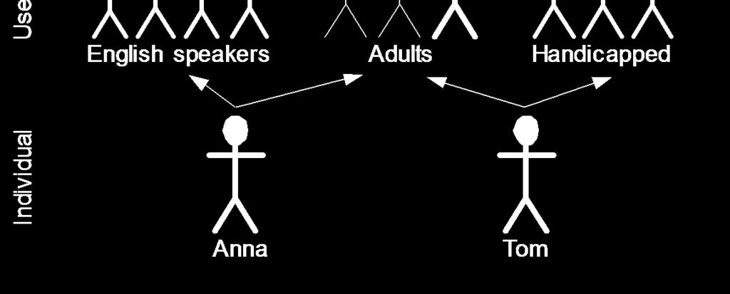
16 Classifying cognitive user parameters 21 Jan 2009 ThinkSpatial, UCSB 16
17 Generic Experimental stream of psychology: general set of cognitive parameters assumed to be applicable to all people. People use landmarks for finding their ways and for communicating wayfinding directions to others. People share numerous cultural universals [Montello 1995] and with regard to these a finer distinction is not required. 21 Jan 2009 ThinkSpatial, UCSB 17
18 Group User groups defined by common sets of cognitive parameters: similar abilities, interests, concerns, goals, beliefs, or behavioral practices. Correlational stream of psychology: variation of parameters between groups. Occur at different hierarchical levels: male vs. female, blind UCSB students What kinds of differences should be taken into account when forming a user group within a particular spatio-temporal context? 21 Jan 2009 ThinkSpatial, UCSB 18
19 Individual Relates to correlational psychology with a focus on individual variation. The more parameters there are that need to be adapted the more difficult and complex it becomes. Individual user preferences: I want to go from location X to location Y by public transport. 21 Jan 2009 ThinkSpatial, UCSB 19
20 Landmark-Based Wayfinding Instructions People usually employ landmarks when mentally representing, describing, and communicating routes in their environment [Lynch 1960, Lovelace et al. 1999, Denis et al. 2006] => generic cognitive strategy. Methods for automatic detection of landmarks for wayfinding instructions [Sadeghian and Kantardzic 2008]. 21 Jan 2009 ThinkSpatial, UCSB 20
21 Landmark saliency measure Measure Property Value Significance (Property) Significance (Measure) Weight Weighted Significance Total Visual attraction α s α β 1 s β1 β 2 s β2 γ s γ δ s δ ε s ε Semantic attraction ζ s ζ η s η Structural attraction θ s θ s vis = (s α + s β1 +s β2 + s γ +s δ ) / 5 s sem = (s ε +s ζ ) / 2 s str = (s η +s θ ) / 2 21 Jan 2009 ThinkSpatial, UCSB 21 w vis w sem w str s vis *w vis s sem *w sem s str *w str s vis *w vis + s sem *w sem + s str *w str [Raubal & Winter 2002]
22 Wayfinding instruction [ AT landmark X ] [ TURN LEFT ] RIGHT MOVE STRAIGHT ] { ONTO streetname Stephansplatz } } { PASSING Stephansdom, CROSSING landmark a visually salient } world cultural heritage building } [ UNTIL landmark Haas building, ] a big building of architectural significance ] 21 Jan 2009 ThinkSpatial, UCSB 22

23 At large yellow building turn left. Walk straight until light green historical building. Turn right 21 Jan 2009 ThinkSpatial, UCSB 23
24 User groups Human participants test on people s landmark selection [Winter et al. 2005] Differences with regard to age, gender, and familiarity with the environment. Differences in landmark selection between day and night. Relative importance of salience measures. Behavioral variation => different weight sets for automatic landmark extraction. 21 Jan 2009 ThinkSpatial, UCSB 24
25 21 Jan 2009 ThinkSpatial, UCSB 25
26 Representing different contexts People select different landmarks by day and night. Weights from subjects scoring of facades. Area Shape Color Visibility Identif. Day Night [Winter, Raubal, Nothegger 2005] 21 Jan 2009 ThinkSpatial, UCSB 26
27 Hotel-Finder Service Influence of different user groups and decision strategies on outcomes of location-based analyses. Ultimate goal: service personalization for the individual. Often user types instead of each user as an individual. [Rinner & Raubal 2004] 21 Jan 2009 ThinkSpatial, UCSB 27
28 Task: find suitable hotel in unfamiliar environment. Current LBS: all hotels within 500m User criteria: proximity price free WiFi check-out time 21 Jan 2009 ThinkSpatial, UCSB 28
29 Approach Subjectively weighted criteria Integrating qualitative user preferences & multi-criteria decision analysis Compensatory vs. non-compensatory decision rules OWA (Ordered Weighted Averaging): Aggregate individual criteria to total evaluation score [Yager 1988] 21 Jan 2009 ThinkSpatial, UCSB 29
30 Interactive approach 1. Select decision criteria. 2. Express preferred criteria values on qualitative scale. 3. Define importance of each criterion. 4. Define personal decision strategy through settings of OWA method. 21 Jan 2009 ThinkSpatial, UCSB 30
31 Calculation b ik = w j a ij (b i1 > > b in ) a ij standardized value of alternative i for criterion j w j weight of criterion j => Alternative i: s i = Σv k b ik v k order weight for the k-th position in reordered sequence of b ik 21 Jan 2009 ThinkSpatial, UCSB 31
 α -((k-1)/n) α [Yager 1988] 21 Jan 2009 ThinkSpatial, UCSB 32")
32 Decision strategies Cognitive component: How much risk does the user take? v k = (k/n) α -((k-1)/n) α [Yager 1988] 21 Jan 2009 ThinkSpatial, UCSB 32
33 Implementation Data for Toronto, Münster Analysis of different user types (business traveler, tourist, low-budget tourist) 21 Jan 2009 ThinkSpatial, UCSB 33


34 21 Jan 2009 ThinkSpatial, UCSB 34

35 Outcomes Personalized results through variation of user type & decision strategy. User preferences => parameters for multicriteria decision analysis. HPT => applying multi-criteria decision strategy enhances people s decision support in unfamiliar environments. [Bäumer, Panov, Raubal 2007] 21 Jan 2009 ThinkSpatial, UCSB 35


36 Critical issues Calculation 21 Jan 2009 ThinkSpatial, UCSB 36
37 Critical issues Calculation User interface 21 Jan 2009 ThinkSpatial, UCSB 37
38 Conclusions GIScience needs cognitive engineering! Geospatial services must be designed and engineered by incorporating principles of human cognition with respect to spatial and temporal aspects of phenomena. This will facilitate HCI and provide highquality support for their users spatiotemporal decision-making. 21 Jan 2009 ThinkSpatial, UCSB 38
39 Conclusions cont. Geospatial services are unique in the way they incorporate spatial & temporal data => spatial cognitive engineering. Users of GI differ in their cognitive styles, abilities, and preferences => personalization of geospatial services. Framework for classifying cognitive user parameters into generic, group, and individual. 21 Jan 2009 ThinkSpatial, UCSB 39
40 Future work Formal Conceptual Representations processing of geographic knowledge validity and limitations of conceptual representations cognitively based spatio-temporal ontologies Spatio-Temporal Decision-Making aspects of uncertainty and vagueness effects of geographic and temporal scales on people s information requirements 21 Jan 2009 ThinkSpatial, UCSB 40


41 Future work cont. Mobile context 21 Jan 2009 ThinkSpatial, UCSB 41 [Raubal & Panov 2009]


42 Cognitive Surveying M.-P. Kwan (Dara-Abrams 2008) 21 Jan 2009 ThinkSpatial, UCSB 42
43 Interdisciplinarity Geography / Geosciences Cognitive Sciences Geoinformatics Computer Science Social Sciences 21 Jan 2009 ThinkSpatial, UCSB 43


44 Thank you for your attention! 21 Jan 2009 ThinkSpatial, UCSB 44

45 21 Jan 2009 ThinkSpatial, UCSB 45
Mappings For Cognitive Semantic Interoperability
 Mappings For Cognitive Semantic Interoperability Martin Raubal Institute for Geoinformatics University of Münster, Germany raubal@uni-muenster.de SUMMARY Semantic interoperability for geographic information
Cognitive Engineering for Geographic Information Science
 Cognitive Engineering for Geographic Information Science 1 Abstract Geographic information science provides the foundation for the development of geospatial tools and services that support people in their
Multi-cultural Aspects of Spatial Knowledge
 Multi-cultural Aspects of Spatial Knowledge Andrew U. Frank Geoinformation TU Vienna frank@geoinfo.tuwien.ac.at www.geoinfo.tuwien.ac.at Andrew Frank 1 Overview 1. What is culture? 2. Cultural influences
The effects of different verbal route instructions on spatial orientation
 Huerta, Schade, Granell (Eds): Connecting a Digital Europe through Location and Place. Proceedings of the AGILE'2014 International Conference on Geographic Information Science, Castellón, June, 3-6, 2014.
A General Framework for Conflation
 A General Framework for Conflation Benjamin Adams, Linna Li, Martin Raubal, Michael F. Goodchild University of California, Santa Barbara, CA, USA Email: badams@cs.ucsb.edu, linna@geog.ucsb.edu, raubal@geog.ucsb.edu,
Environmental Cognition and Perception I
 Environmental Cognition and Perception I Review: Spatial Interaction and Spatial Behavior II - Individual travel behavior - Activity space - Mental maps How we perceive the environment Maps in the head
Geospatial Semantics. Yingjie Hu. Geospatial Semantics
 Outline What is geospatial? Why do we need it? Existing researches. Conclusions. What is geospatial? Semantics The meaning of expressions Syntax How you express the meaning E.g. I love GIS What is geospatial?
Geoinformation in Environmental Modelling
 Geoinformation in Environmental Modelling Introduction to the topics ENY-C2005 Salla Multimäki 4.1.2017 Topics today Orientation to geoinformation in environmental modelling to form the big picture and
GIScience & Mobility. Prof. Dr. Martin Raubal. Institute of Cartography and Geoinformation SAGEO 2013 Brest, France
 GIScience & Mobility Prof. Dr. Martin Raubal Institute of Cartography and Geoinformation mraubal@ethz.ch SAGEO 2013 Brest, France 25.09.2013 1 www.woodsbagot.com 25.09.2013 2 GIScience & Mobility Modeling
DATA COLLECTION & SAMPLING
 DATA COLLECTION & SAMPLING The Local Landscape Spring 2015 Preparing for data collection Increase background knowledge Research Plan Field Recon Test field methods Field reconnaissance Visit geographic
for an Informed Analysis of A Socio-Economic Perspective Adrijana Car, Marike Bontenbal and Marius Herrmann
 Creating a GIS-Base for an Informed Analysis of Tourism Development: A Socio-Economic Perspective Adrijana Car, Marike Bontenbal and Marius Herrmann adrijana.car@gutech.edu.om edu GSS 2012 Affiliated to:
GPS-tracking Method for Understating Human Behaviours during Navigation
 GPS-tracking Method for Understating Human Behaviours during Navigation Wook Rak Jung and Scott Bell Department of Geography and Planning, University of Saskatchewan, Saskatoon, SK Wook.Jung@usask.ca and
Urban GIS for Health Metrics
 Urban GIS for Health Metrics Dajun Dai Department of Geosciences, Georgia State University Atlanta, Georgia, United States Presented at International Conference on Urban Health, March 5 th, 2014 People,
Landmarks selection in street map design
 IOP Conference Series: Earth and Environmental Science OPEN ACCESS Landmarks selection in street map design To cite this article: C J Kao 2014 IOP Conf. Ser.: Earth Environ. Sci. 18 012075 View the article
Geoinformation in Environmental Modelling
 Geoinformation in Environmental Modelling Introduction to the topics ENY-C2005 Jaakko Madetoja 5.1.2018 Slides by Paula Ahonen-Rainio Topics today Orientation to geoinformation in environmental modelling
FUNDAMENTALS OF GEOINFORMATICS PART-II (CLASS: FYBSc SEM- II)
") FUNDAMENTALS OF GEOINFORMATICS PART-II (CLASS: FYBSc SEM- II) UNIT:-I: INTRODUCTION TO GIS 1.1.Definition, Potential of GIS, Concept of Space and Time 1.2.Components of GIS, Evolution/Origin and Objectives
FUNDAMENTALS OF GEOINFORMATICS PART-II (CLASS: FYBSc SEM- II) UNIT:-I: INTRODUCTION TO GIS 1.1.Definition, Potential of GIS, Concept of Space and Time 1.2.Components of GIS, Evolution/Origin and Objectives
Towards landmark-based instructions for pedestrian navigation systems using OpenStreetMap
 Towards landmark-based instructions for pedestrian navigation systems using OpenStreetMap Anita Graser AIT Austrian Institute of Technology Giefinggasse 2 Vienna, Austria anita.graser@ait.ac.at Abstract
Your web browser (Safari 7) is out of date. For more security, comfort and. the best experience on this site: Update your browser Ignore
 is out of date. For more security, comfort and. the best experience on this site: Update your browser Ignore") Your web browser (Safari 7) is out of date. For more security, comfort and Activityengage the best experience on this site: Update your browser Ignore Introduction to GIS What is a geographic information
Your web browser (Safari 7) is out of date. For more security, comfort and Activityengage the best experience on this site: Update your browser Ignore Introduction to GIS What is a geographic information
Geo-identification and pedestrian navigation with geo-mobile applications: how do users proceed?
 TU Vienna presentation 17 th July 2008 Geo-identification and pedestrian navigation with geo-mobile applications: how do users proceed? Ioannis Delikostidis Corné van Elzakker INTERNATIONAL INSTITUTE FOR
Cognitive OpenLS Extending XML for location services by a high-level cognitive framework
 Cognitive OpenLS Extending XML for location services by a high-level cognitive framework Diplomarbeit Fachbereich Informatik, Universität Bremen April 10, 2006 Stefan Hansen Betreuer: Dr. Alexander Klippel
Turn Left after the WC, and Use the Lift to Go to the 2nd Floor Generation of Landmark-Based Route Instructions for Indoor Navigation
 International Journal of Geo-Information Article Turn Left after the WC, and Use the Lift to Go to the 2nd Floor Generation of Landmark-Based Route Instructions for Indoor Navigation Irene Fellner 1, Haosheng
What is GIS? G: Geographic, Geospatial, Geo
 GEOG 488/588: GIS I Introduction Instructor: Geoffrey Duh TA: David Graves What is GIS? G: Geographic, Geospatial, Geo Alternatives: Spatial Information Systems, Land Information Systems Geography diverse
Personalized Multi-Criteria Decision Strategies in Location-based Decision Support
 Ryerson University Digital Commons @ Ryerson Geography Publications and Research Geography 1-1-2004 Personalized Multi-Criteria Decision Strategies in Location-based Decision Support Claus Rinner Ryerson
Environmental Cognition and Perception II
 Environmental Cognition and Perception II Review: Environmental Cognition and Perception I - Knowledge about environments - Systematic distortions - Development of spatial knowledge - Individual and group
Future Proofing the Provision of Geoinformation: Emerging Technologies
 Future Proofing the Provision of Geoinformation: Emerging Technologies An Exchange Forum with the Geospatial Industry William Cartwright Chair JBGIS Second High Level Forum on Global Geospatial Information
Enriching Wayfinding Instructions with Local Landmarks
 Enriching Wayfinding Instructions with Local Landmarks Martin Raubal 1 and Stephan Winter 2 1 Institute for Geoinformatics, University of Münster, Robert-Koch-Str. 26-28, 48149 Münster, Germany raubal@ifgi.uni-muenster.de
Variation of geospatial thinking in answering geography questions based on topographic maps
 Variation of geospatial thinking in answering geography questions based on topographic maps Yoshiki Wakabayashi*, Yuri Matsui** * Tokyo Metropolitan University ** Itabashi-ku, Tokyo Abstract. This study
Welcome to GST 101: Introduction to Geospatial Technology. This course will introduce you to Geographic Information Systems (GIS), cartography,
, cartography,") Welcome to GST 101: Introduction to Geospatial Technology. This course will introduce you to Geographic Information Systems (GIS), cartography, remote sensing, and spatial analysis through a series of
Welcome to GST 101: Introduction to Geospatial Technology. This course will introduce you to Geographic Information Systems (GIS), cartography, remote sensing, and spatial analysis through a series of
Three-Dimensional Visualization of Activity-Travel Patterns
 C. Rinner 231 Three-Dimensional Visualization of Activity-Travel Patterns Claus Rinner Department of Geography University of Toronto, Canada rinner@geog.utoronto.ca ABSTRACT Geographers have long been
Generation of landmarks from 3D city models and OSM data
 Editors: Jérôme Gensel, Didier Josselin and Danny Vandenbroucke Generation of landmarks from 3D city models and OSM data Eva Nuhn Eva.nuhn@unibw.de Wolfgang Reinhardt Wolfgang.reinhardt@unibw.de Abstract
Techniques for Science Teachers: Using GIS in Science Classrooms.
 Techniques for Science Teachers: Using GIS in Science Classrooms. After ESRI, 2008 GIS A Geographic Information System A collection of computer hardware, software, and geographic data used together for
Spatial Knowledge Acquisition in the Context of GPS-based Pedestrian Navigation
 Spatial Knowledge Acquisition in the Context of GPS-based Pedestrian Navigation Haosheng Huang, Manuela Schmidt, Georg Gartner Institute of Geoinformation and Cartography, Vienna University of Technology
Zero Hours of System Training
 Zero Hours of System Training A challenge for the next 25 years Werner Kuhn Center for Spatial Studies Department of Geography University of California at Santa Barbara 1854 http://en.wikipedia.org/wiki/file:snow-cholera-map-1.jpg
Indoor Landmark and Indoor Wayfinding: The Indoor Landmark Identification issue
 Technische Universität München Department of Civil, Geo and Environmental Engineering Chair of Cartography Prof. Dr.-Ing. Liqiu Meng Indoor Landmark and Indoor Wayfinding: The Indoor Landmark Identification
Application of WebGIS and VGI for Community Based Resources Inventory. Jihn-Fa Jan Department of Land Economics National Chengchi University
 Application of WebGIS and VGI for Community Based Resources Inventory Jihn-Fa Jan Department of Land Economics National Chengchi University OUTLINE Introduction Methodology Results Conclusions 2 MOTIVATION
Landmark-based pedestrian navigation
 Landmark-based pedestrian navigation Anahid Basiri, Adam Winstanley, Pouria Amirian Department of Computer Science, National University of Ireland Maynooth (NUIM) Maynooth, Ireland Tel. (+353 17084794)
2013 AND 2025 THE FUTURE OF GIS
 THE FUTURE OF GIS 2013 AND 2025 What is the state of geospatial computing today? What are the issues today? Unresolved problems What will geospatial computing be like in 2025? What issues will be of concern
Research Group Cartography
 Research Group Cartography Research Group Cartography Towards supporting wayfinding LBS components 1. Mobile devices 2. Communication Network 3. Positioning Component 4. Service and Application Provider
4CitySemantics. GIS-Semantic Tool for Urban Intervention Areas
 4CitySemantics GIS-Semantic Tool for Urban Intervention Areas Nuno MONTENEGRO 1 ; Jorge GOMES 2 ; Paulo URBANO 2 José P. DUARTE 1 1 Faculdade de Arquitectura da Universidade Técnica de Lisboa, Rua Sá Nogueira,
Research on Object-Oriented Geographical Data Model in GIS
 Research on Object-Oriented Geographical Data Model in GIS Wang Qingshan, Wang Jiayao, Zhou Haiyan, Li Bin Institute of Information Engineering University 66 Longhai Road, ZhengZhou 450052, P.R.China Abstract
Place Syntax Tool (PST)
") Place Syntax Tool (PST) Alexander Ståhle To cite this report: Alexander Ståhle (2012) Place Syntax Tool (PST), in Angela Hull, Cecília Silva and Luca Bertolini (Eds.) Accessibility Instruments for Planning
Place Syntax Tool (PST) Alexander Ståhle To cite this report: Alexander Ståhle (2012) Place Syntax Tool (PST), in Angela Hull, Cecília Silva and Luca Bertolini (Eds.) Accessibility Instruments for Planning
ENV208/ENV508 Applied GIS. Week 1: What is GIS?
 ENV208/ENV508 Applied GIS Week 1: What is GIS? 1 WHAT IS GIS? A GIS integrates hardware, software, and data for capturing, managing, analyzing, and displaying all forms of geographically referenced information.
Spatial Intelligence. Angela Schwering
 Spatial Intelligence Angela Schwering What I do What I do intelligent representation and processing of spatial information From the Cognitive Perspective How do humans perceive spatial information? How
A semantic and language-based model of landscape scenes
 A semantic and language-based model of landscape scenes Jean-Marie Le Yaouanc, Éric Saux, Christophe Claramunt Naval Academy Research Institute, BP 600, 29240, Brest Naval, France {leyaouanc, saux, claramunt}@ecole-navale.fr
A route map to calibrate spatial interaction models from GPS movement data
 A route map to calibrate spatial interaction models from GPS movement data K. Sila-Nowicka 1, A.S. Fotheringham 2 1 Urban Big Data Centre School of Political and Social Sciences University of Glasgow Lilybank
Site Suitability Analysis for Local Airport Using Geographic Information System
 Cloud Publications International Journal of Advanced Remote Sensing and GIS 2018, Volume 7, Issue 1, pp. 2719-2727 ISSN 2320 0243, Crossref: 10.23953/cloud.ijarsg.368 Research Article Site Suitability
Online visualization of multi-dimensional spatiotemporal
 Online visualization of multi-dimensional spatiotemporal data Visualization of weather data of Germany in a large time scale Keni Han Final presentation Supervisor: Dr.-Ing. Mathias Jahnke Univ.Prof. Mag.rer.nat.
Contents. Interactive Mapping as a Decision Support Tool. Map use: From communication to visualization. The role of maps in GIS
 Contents Interactive Mapping as a Decision Support Tool Claus Rinner Assistant Professor Department of Geography University of Toronto otru gis workshop rinner(a)geog.utoronto.ca 1 The role of maps in
Geographic Information Systems (GIS) in Environmental Studies ENVS Winter 2003 Session III
 in Environmental Studies ENVS Winter 2003 Session III") Geographic Information Systems (GIS) in Environmental Studies ENVS 6189 3.0 Winter 2003 Session III John Sorrell York University sorrell@yorku.ca Session Purpose: To discuss the various concepts of space,
Geographic Information Systems (GIS) in Environmental Studies ENVS 6189 3.0 Winter 2003 Session III John Sorrell York University sorrell@yorku.ca Session Purpose: To discuss the various concepts of space,
SPATIAL NARRATIVES FROM MOBILE GIS - the case of H.C.Andersen in Copenhagen
 SPATIAL NARRATIVES FROM MOBILE GIS - the case of H.C.Andersen in Copenhagen Lasse Møller-Jensen Department of Geography and Geology, University of Copenhagen, Denmark Øster Voldgade 10, 1350 Copenhagen
Supporting movement patterns research with qualitative sociological methods gps tracks and focus group interviews. M. Rzeszewski, J.
 Supporting movement patterns research with qualitative sociological methods gps tracks and focus group interviews M. Rzeszewski, J. Kotus Adam Mickiewicz University, ul. Dziegielowa 27, 61-680 Poznan,
University of Lusaka
 University of Lusaka BSPH 315 Health Mapping & GIS Topic: Background of GIS Content: 1. Aim of the course 2. What do you know about GIS? 3. Difference between geographic data and geographic information
A Spatial Analytical Methods-first Approach to Teaching Core Concepts
 Thomas Hervey 4.24.18 A Spatial Analytical Methods-first Approach to Teaching Core Concepts Introduction Teaching geospatial technologies is notoriously difficult regardless of the learning audience. Even
Asset Management Planning. GIS and Asset Management Integration Readiness Assessment
 Asset Management Planning GIS and Asset Management Integration Readiness Assessment With too little data, you won t be able to make any conclusions that you trust. With loads of data you will find relationships
Hypothesis testing. Data to decisions
 Hypothesis testing Data to decisions The idea Null hypothesis: H 0 : the DGP/population has property P Under the null, a sample statistic has a known distribution If, under that that distribution, the
Welcome Survey getting to know you Collect & log Supplies received Classroom Rules Curriculum overview. 1 : Aug 810. (3 days) 2nd: Aug (5 days)
 2nd: Aug (5 days)") 1st Quarter (41Days) st 1 : Aug 810 (3 days) 2nd: Aug 13-17 Reporting Categories (TEKS SEs) Skill Create and write a postcard about your favorite community activity Review 2nd Grade Vocabulary Chapter
1st Quarter (41Days) st 1 : Aug 810 (3 days) 2nd: Aug 13-17 Reporting Categories (TEKS SEs) Skill Create and write a postcard about your favorite community activity Review 2nd Grade Vocabulary Chapter
Grade 6 Social Studies
 Grade 6 Social Studies Social Studies Grade(s) 6th Course Overview This course focuses on the five Wisconsin Model Academic standards for Social Studies: Geography, History, Political Science and Citizenship,
Fundamentals of Geographic Information System PROF. DR. YUJI MURAYAMA RONALD C. ESTOQUE JUNE 28, 2010
 Fundamentals of Geographic Information System 1 PROF. DR. YUJI MURAYAMA RONALD C. ESTOQUE JUNE 28, 2010 CONTENTS OF THIS LECTURE PRESENTATION Basic concept of GIS Basic elements of GIS Types of GIS data
ALTER ECO Alternative tourist strategies to enhance the local sustainable development of tourism by promoting Mediterranean identity Module 2: Testing
 ALTER ECO Alternative tourist strategies to enhance the local sustainable development of tourism by promoting Mediterranean identity Module 2: Testing WHY? Areas of high tourism attraction in coastal cities
Purpose Study conducted to determine the needs of the health care workforce related to GIS use, incorporation and training.
 GIS and Health Care: Educational Needs Assessment Cindy Gotz, MPH, CHES Janice Frates, Ph.D. Suzanne Wechsler, Ph.D. Departments of Health Care Administration & Geography California State University Long
GIS FOR MAZOWSZE REGION - GENERAL OUTLINE
 GIS FOR MAZOWSZE REGION - GENERAL OUTLINE S. Bialousz 1), K Mączewski 2), E. Janczar 2), K. Osinska-Skotak 1) 1) Warsaw University of Technology, Warsaw, Poland 2) Office of the Surveyor of the Mazowieckie
Lecture 1: Geospatial Data Models
 Lecture 1: GEOG413/613 Dr. Anthony Jjumba Introduction Course Outline Journal Article Review Projects (and short presentations) Final Exam (April 3) Participation in class discussions Geog413/Geog613 A
Applications of GIS in Electrical Power System
 Applications of GIS in Electrical Power System Abdulrahman M. AL-Sakkaf 201102310 CRP 514 May 2013 Dr. Baqer M. AL-Ramadan Abstract GIS has been widely used in various areas and disciplines. This paper
Minnesota Transportation Museum
 Minnesota Transportation Museum Minnesota Social Studies s Alignment Second Grade 1 Code Benchmark 1. Citizenship and Government 1. Civic Skills. Civic Values and Principles of Democracy 4. Governmental
Haosheng Huang, Manuela Schmidt and Georg Gartner
 Spatial Knowledge Acquisition with Mobile Maps, Augmented Reality and Voice in the Context of GPS-based Pedestrian Navigation: Results from a Field Test Haosheng Huang, Manuela Schmidt and Georg Gartner
The Importance of Spatial Literacy
 The Importance of Spatial Literacy Dr. Michael Phoenix GIS Education Consultant Taiwan, 2009 What is Spatial Literacy? Spatial Literacy is the ability to be able to include the spatial dimension in our
An Ontology-based Framework for Modeling Movement on a Smart Campus
 An Ontology-based Framework for Modeling Movement on a Smart Campus Junchuan Fan 1, Kathleen Stewart 1 1 Department of Geographical and Sustainability Sciences, University of Iowa, Iowa City, IA, 52242,
Laboratory on Geoinformatics and Cartography
 Research on usability testing and cognitive issues of cartographic visualizations in the context of different groups of users Milan Konečný Čeněk Šašinka, Zbyněk Štěrba Masaryk University, Brno, CZ 19.
Representing and Visualizing Travel Diary Data: A Spatio-temporal GIS Approach
 2004 ESRI International User Conference, San Diego, CA Representing and Visualizing Travel Diary Data: A Spatio-temporal GIS Approach Hongbo Yu and Shih-Lung Shaw Abstract Travel diary data (TDD) is an
TRAITS to put you on the map
 TRAITS to put you on the map Know what s where See the big picture Connect the dots Get it right Use where to say WOW Look around Spread the word Make it yours Finding your way Location is associated with
Massachusetts Institute of Technology Department of Urban Studies and Planning
 Massachusetts Institute of Technology Department of Urban Studies and Planning 11.204: Planning, Communications & Digital Media Fall 2002 Lecture 6: Tools for Transforming Data to Action Lorlene Hoyt October
Spatial Data Science. Soumya K Ghosh
 Workshop on Data Science and Machine Learning (DSML 17) ISI Kolkata, March 28-31, 2017 Spatial Data Science Soumya K Ghosh Professor Department of Computer Science and Engineering Indian Institute of Technology,
Oakland County Parks and Recreation GIS Implementation Plan
 Oakland County Parks and Recreation GIS Implementation Plan TABLE OF CONTENTS 1.0 Introduction... 3 1.1 What is GIS? 1.2 Purpose 1.3 Background 2.0 Software... 4 2.1 ArcGIS Desktop 2.2 ArcGIS Explorer
Interactive Visualization Tool (InViTo)
") Interactive Visualization Tool (InViTo) Stefano Pensa To cite this report: Stefano Pensa (2012) Interactive Visualization Tool (InViTo), in Angela Hull, Cecília Silva and Luca Bertolini (Eds.) Accessibility
Interactive Visualization Tool (InViTo) Stefano Pensa To cite this report: Stefano Pensa (2012) Interactive Visualization Tool (InViTo), in Angela Hull, Cecília Silva and Luca Bertolini (Eds.) Accessibility
Geography for the 2020 Round of Census
 Boundaries Key Census Data EA Id Population Male Female EA Id Area EA Id Num HH Avg HH size Geography for the 2020 Round of Census Linda Peters, Esri lpeters@esri.com Integration of Statistical and Geospatial
Estimation of the Subjective Topological Structure of Action Spaces using Learning Agents
 Estimation of the Subjective Topological Structure of Action Spaces using Learning Agents Ed Manley Department of Civil, Environmental and Geomatic Engineering University College London ucesejm@ucl.ac.uk
geographic patterns and processes are captured and represented using computer technologies
 Proposed Certificate in Geographic Information Science Department of Geographical and Sustainability Sciences Submitted: November 9, 2016 Geographic information systems (GIS) capture the complex spatial
Integration for Informed Decision Making
 Geospatial and Statistics Policy Intervention: Integration for Informed Decision Making Greg Scott Global Geospatial Information Management United Nations Statistics Division Department of Economic and
Dublin City Schools Social Studies Graded Course of Study Grade 5 K-12 Social Studies Vision
 K-12 Social Studies Vision The Dublin City Schools K-12 Social Studies Education will provide many learning opportunities that will help students to: develop thinking as educated citizens who seek to understand
Reducing Consumer Uncertainty
 Spatial Analytics Reducing Consumer Uncertainty Eliciting User and Producer Views on Geospatial Data Quality Introduction Cooperative Research Centre for Spatial Information (CRCSI) in Australia Communicate
Estimating Large Scale Population Movement ML Dublin Meetup
 Deutsche Bank COO Chief Data Office Estimating Large Scale Population Movement ML Dublin Meetup John Doyle PhD Assistant Vice President CDO Research & Development Science & Innovation john.doyle@db.com
Combining Geospatial and Statistical Data for Analysis & Dissemination
 Combining Geospatial and Statistical Data for Analysis & Dissemination (with Special Reference to Qatar Census 2010) Presentation by Mansoor Al Malki, Director of IT Department Qatar Statistics Authority
ASIA GEOSPATIAL FORUM 2011 Eco-Friendly Walk Score Calculator Choosing a Place to Live with GIS
 ASIA GEOSPATIAL FORUM 2011 Eco-Friendly Walk Score Calculator Choosing a Place to Live with GIS Ko Ko Lwin and Yuji Murayama Division of Spatial Information Science Graduate School of Life and Environmental
Introduction-Overview. Why use a GIS? What can a GIS do? Spatial (coordinate) data model Relational (tabular) data model
 data model Relational (tabular) data model") Introduction-Overview Why use a GIS? What can a GIS do? How does a GIS work? GIS definitions Spatial (coordinate) data model Relational (tabular) data model intro_gis.ppt 1 Why use a GIS? An extension
Introduction-Overview Why use a GIS? What can a GIS do? How does a GIS work? GIS definitions Spatial (coordinate) data model Relational (tabular) data model intro_gis.ppt 1 Why use a GIS? An extension
Structural Salience as a Landmark
 Structural Salience as a Landmark Introduction Alexander Klippel 1, Kai-Florian Richter 2, Stefan Hansen 2 1 Cooperative Research Centre for Spatial Information The University of Melbourne, Australia aklippel@unimelb.edu.au
TEMPLATE FOR CMaP PROJECT
 TEMPLATE FOR CMaP PROJECT Project Title: Native Utah Plants Created by: Anna Davis Class: Box Elder 2008 Project Description Community Issue or Problem Selected -How project evolved? Community Partner(s)
ArcGIS Enterprise: What s New. Philip Heede Shannon Kalisky Melanie Summers Sam Williamson
 ArcGIS Enterprise: What s New Philip Heede Shannon Kalisky Melanie Summers Sam Williamson ArcGIS Enterprise is the new name for ArcGIS for Server What is ArcGIS Enterprise ArcGIS Enterprise is powerful
REASONING PROCESSES UNDERLYING THE EXPLANATION OF THE PHASES OF THE MOON.
 REASONING PROCESSES UNDERLYING THE EXPLANATION OF THE PHASES OF THE MOON. Shamin Padalkar and K. Subramaniam Homi Bhabha Centre for Science Education (TIFR) Mumbai OBJECTIVES AND SIGNIFICANCE OF THE STUDY
Intelligent GIS: Automatic generation of qualitative spatial information
 Intelligent GIS: Automatic generation of qualitative spatial information Jimmy A. Lee 1 and Jane Brennan 1 1 University of Technology, Sydney, FIT, P.O. Box 123, Broadway NSW 2007, Australia janeb@it.uts.edu.au
South Carolina Standards & Learning Science Grade: 2 - Adopted: 2014
 Main Criteria: South Carolina Standards & Learning Secondary Criteria: Subjects: Science, Social Studies Grade: 2 Correlation Options: Show Correlated South Carolina Standards & Learning Science Grade:
What are the five components of a GIS? A typically GIS consists of five elements: - Hardware, Software, Data, People and Procedures (Work Flows)
") LECTURE 1 - INTRODUCTION TO GIS Section I - GIS versus GPS What is a geographic information system (GIS)? GIS can be defined as a computerized application that combines an interactive map with a database
LECTURE 1 - INTRODUCTION TO GIS Section I - GIS versus GPS What is a geographic information system (GIS)? GIS can be defined as a computerized application that combines an interactive map with a database
South Carolina Standards & Learning Science Grade: 1 - Adopted: 2014
 Main Criteria: South Carolina Standards & Learning Secondary Criteria: Subjects: Science, Social Studies Grade: 1 Correlation Options: Show Correlated South Carolina Standards & Learning Science Grade:
Cell-based Model For GIS Generalization
 Cell-based Model For GIS Generalization Bo Li, Graeme G. Wilkinson & Souheil Khaddaj School of Computing & Information Systems Kingston University Penrhyn Road, Kingston upon Thames Surrey, KT1 2EE UK
AN APPROACH FOR INDOOR WAYFINDING REPLICATING MAIN PRINCIPLES OF AN OUTDOOR NAVIGATION SYSTEM FOR CYCLISTS
 AN APPROACH FOR INDOOR WAYFINDING REPLICATING MAIN PRINCIPLES OF AN OUTDOOR NAVIGATION SYSTEM FOR CYCLISTS A. Makri a, S. Zlatanova b, E. Verbree c a MSc Geomatics, Faculty of Architecture and the Built
Applications of GIS in Electrical Power System. Dr. Baqer AL-Ramadan Abdulrahman Al-Sakkaf
 Applications of GIS in Electrical Power System Dr. Baqer AL-Ramadan Abdulrahman Al-Sakkaf OUTLINES: Objective Importance of GIS GIS data development Application of GIS Findings Conclusions and Recommendations
Indoor Scene Knowledge Acquisition using a Natural Language Interface Saranya Kesavan and Nicholas A. Giudice
 Indoor Scene Knowledge Acquisition using a Natural Language Interface Saranya Kesavan and Nicholas A. Giudice School of Computing and Information Science Spatial Informatics Program, University of Maine
Introduction to Human Geography & Geographic Concepts
 Introduction to Human Geography & Geographic Concepts What is Geography? Literal definition: Description of the Earth Serves as a bridge between physical and human sciences the study of the earth and its
LRS Task Force June 13, REVISION HISTORY
 North Carolina Department of Transportation Geographic Information Systems (GIS) Unit LINEAR REFERENCING SYSTEM (LRS) PROJECT DEFINITION Version 1.0 REVISION HISTORY Date Document Manager Revision Purpose
GIS for the Beginner on a Budget
 GIS for the Beginner on a Budget Andre C. Bally, RLA, GIS Coordinator, Harris County Public Infrastructure Department Engineering Division This presentation, GIS for Beginners on a Budget. will briefly
Time Series Analysis with SAR & Optical Satellite Data
 Time Series Analysis with SAR & Optical Satellite Data Thomas Bahr ESRI European User Conference Thursday October 2015 harris.com Motivation Changes in land surface characteristics mirror a multitude of