Research Group Cartography
|
|
|
- Roger Holland
- 6 years ago
- Views:
Transcription

1 Research Group Cartography


2 Research Group Cartography Towards supporting wayfinding
3 LBS components 1. Mobile devices 2. Communication Network 3. Positioning Component 4. Service and Application Provider 5. Data and Content Provider


4 Navigation Car navigation,,pedestrian Navigation Google Map Navigation Wikitude Drive


5 Mobile guides AR+Wikipedia=Wikitude Nokia: Mobile Augmented Reality Applications
6 Location-based game Geocaching: a worldwide game of hiding and seeking treasure. A geocacher can place a geocache in the world, pinpoint its location using GPS technology and then share the geocache's existence and location online. Anyone with a GPS device can then try to locate the geocache.


7 Foursquare: check-in Social networking

8 Research Group Cartography Pedestrian Navigation
9 Master Plan 1 Sensor Fusion 2 Ubiquitous Infrastructure 3 Behaviour Modelling 4 Semantic Wayfinding 5 Landmark Taxonomies 6 Context-Awareness 7 Keyhole Effects 8 Communication and Interfaces 9 Pragmatic Wayfinding


10 TU VIENNA/RGC ARCHITECTURE CLIEN T Navigation Guidance Interaction & Annotation Positioning Modelling and Communication User Tracking Multi-sensor Fusion Model Context-aware Route Calculation Context-aware Route Communication Gathering real-time information Context Gathering & Reasoning Data Mining & Analyzing Accumulating historical data SMART ENVIRONMENT Typology Tracking/Interaction Database
11 Research Group Cartography Data acquisition and Modeling Data acquisition and Modeling Collaborative Filtering
12 Research Group Cartography Augmented Reality and Social Media
13 Research Group Cartography Behaviour modelling Cluster 1 Cluster 2 Cluster 3 Gender f: 40% f: 36% f: 67% m: 60% m: 64% m: 33% Age ~ 30 ~ ~ Duration of observation ~ 5 min ~ 10 min ~ 23 min Speed ~ 1.2 m/s ~ 0.6 m/s ~ 0.2 m/s Number of stops almost none Duration of stops 7sec 25min min 4.7 (max. 1 min) (max. 8 min) (max. 17 min)


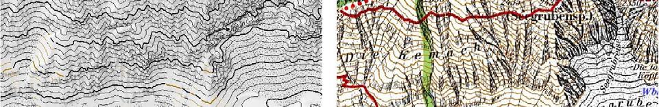
14 Research Group Cartography Semantic Wayfinding Urban area in situ experiments in Vienna and Slb Salzburg, oral descriptions of environment and possible actions abou utpixel.de Raine er Sturm Ski touring additional experiments for comparison photoc case.de oliverm mick


15 SemWay "Gehen Sie an der Felsformation links vorbei im Tal hinauf."


16 ..engineering the semantic dimension

17 Research Group Cartography Ways2navigate


18 Research Group Cartography Keyhole Problem
19 Research Group Cartography FemRoute, Fem2Map How do the psychological route qualities attractiveness, convenience and safety depend on the context of use? 19
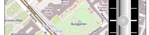
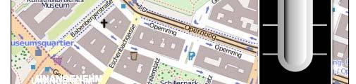
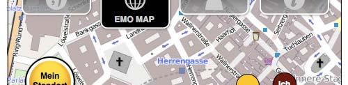
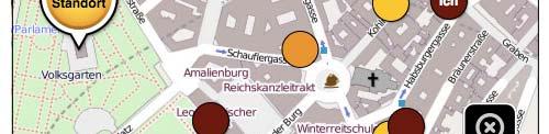
20 Research Group Cartography EmoMap Considering the emotional perception of space in navigation systems for pedestrians Project goals 1. Gathering relevant parameters from pedestrians for creating an emotional layer of Vienna 2. Contributions via VGI to an open online database OpenEmotionMap.org 3. Using collected data for improving/personalizing pedestrian navigation
21 Research Group Cartography Hypothesis The strength of emotional attachment for a particular landmark, place or space embedded bddd in memory, by an individual, influences our structuring of space, thus our identity building and well being
22 Research Group Cartography Concept applying crowdsourcing methods using state-of-the-art t th ttools/social lmedia correlate with psychological findings Evaluate (focus groups, CF)

23 Research Group Cartography


24 Research Group Cartography
25 Research Group Cartography App Android Platforms OSM GPS location downloadable from cartography.tuwien.ac.at
26 Research Group Cartography
27 Research Group Cartography Openemotionmap.org
28 International Cartographic Association
29 International Cartographic Association mission the world authorative body for cartography the world authorative body for cartography and geoinformation science
30 International Cartographic Association mission world authority means national and affilate members represented at UN bodies and other international organisations
31 International Cartographic Association Aims Understanding and solve world wide wide problems using cartography Informing about environmental, economical, social and spatial information through mapping Promote professional methods, techniques and solutions Global forum on cartography..
32 International Cartographic Association Commissions Commission on Art and Cartography Commission on Atlases Commission on Cartography and Children Commission on Cartography in Early Warning and Crisis Management Commission on Cognitive Visualization Commission on Data Quality Commission on Digital Technologies in Cartographic Heritage Commission on Education and Training Commission on Generalisation and Multiple Representation Commission on Geoinformation Infrastructures and Standards Commission on Geospatial Analysis and Modeling Commission on Geovisualization Commission on GI for Sustainability Commission on the History of Cartography Commission on Map Design Commission on Map Production and Geo-Business Commission on Map Projections Commission on Mapping from Remote Sensor Imagery Commission on Maps and Graphics for Blind and Partially Sighted People Commission on Maps and Society Commission on Maps and the Internet Commission on Mountain Cartography Commission on Neocartography Commission on Open Source Geospatial Technologies Commission on Planetary Cartography Commission on Theoretical Cartography Commission on Ubiquitous Mapping Commission on Use and User Issues
33 International Cartographic Association Commissions Commission on Art and Cartography Commission on Atlases Commission on Cartography and Children Commission on Cartography in Early Warning and Crisis Management Commission on Cognitive Visualization Commission on Data Quality Commission on Digital Technologies in Cartographic Heritage Commission on Education and Training Commission on Generalisation and Multiple Representation Commission on Geoinformation Infrastructures and Standards Commission on Geospatial Analysis and Modeling Commission on Geovisualization Commission on GI for Sustainability Commission on the History of Cartography Commission on Map Design Commission on Map Production and Geo-Business Commission on Map Projections Commission on Mapping from Remote Sensor Imagery Commission on Maps and Graphics for Blind and Partially Sighted People Commission on Maps and Society Commission on Maps and the Internet Commission on Mountain Cartography Commission on Neocartography Commission on Open Source Geospatial Technologies Commission on Planetary Cartography Commission on Theoretical Cartography Commission on Ubiquitous Mapping Commission on Use and User Issues

34 International Cartographic Association Instruments: Publications
35 International Cartographic Association Instruments: Maps (Exhibitions, Awards)
36 International Cartographic Association Instruments: Research Agenda Geographic Information Mtdt Metadata and SDI Geospatial Analysis and Modelling Usability Geovisualisation Map Production Cartographic Theory History of Cartography and GI Science Education Society


37 International Cartographic Association Instruments: Conferences International Cartographic Conference August 2013, Dresden, Germany
38 International Cartographic Association Instruments: Conferences International Cartographic Conference International Cartographic Conference August 2015 Rio de Janeiro, Brasil

39 International Cartographic Association
The Relevance of Cartography. Dubai 2015, Georg Gartner
 The Relevance of Cartography Dubai 2015, Georg Gartner Where are we? Data! Data? We are not short of data Technologies! Technologies? We are not short of technologies Data-driven and technology-driven
Web 2.0, map production & publishing and geospatial information dissemenation
 Web 2.0, map production & publishing and geospatial information dissemenation Professor William Cartwright President, International Cartographic Association William Cartwright 18th UNRCC for Asia and the
Maps and sustainability
 Maps and sustainability The International Map Year [ mapyear.org ] Menno-Jan Kraak Maps Cartography and maps A map is a visual representation of an environment maps tell stories maps invite maps show patterns
Themes for Geomatics Conference. Geodesy Themes
 Themes for Geomatics Conference Geodesy Themes Geodynamics o Modeling the Deformation of the Earth s Crust o Recent Advances in Geometric Approaches to Deformation Analysis o Monitoring Systems (Sensors
ROLE ICA VE KARTOGRAFIE.
 ROLE ICA VE KARTOGRAFIE Is Cartography s there is quite some confusion about the status, relevance and importance of Cartography w business debates amongst major software companies, in mass market applications
Manual of Digital Earth
 V8.0 March 27, 2018 International Society for Digital Earth Manual of Digital Earth (Tentative Title) OUTLINE Foreword Chapter 1 Understanding Digital Earth 1.1 Origins and Precursors of Digital Earth
The 2010 Census Successful Because of GIS
 The 2010 Census Successful Because of GIS Timothy F. Trainor Chief, Geography Division, U.S. Census Bureau Vice President, International Cartographic Association Establishing the Framework of the Operation
Exploit your geodata to enable smart cities and countries
 Exploit your geodata to enable smart cities and countries Carsten Rönsdorf, Head of Advisory Services Middle East Practice Manager Future Cities, standards and 3D 24 November 2014 Importance of Standards
3D MAPS SCALE, ACCURACY, LEVEL OF DETAIL
 26 th International Cartographic Conference August 25 30, 2013 Dresden, Germany 3D MAPS SCALE, ACCURACY, LEVEL OF DETAIL Prof. Dr. Temenoujka BANDROVA Eng. Stefan BONCHEV University of Architecture, Civil
VGIscience Summer School Interpretation, Visualisation and Social Computing of Volunteered Geographic Information (VGI)
") VGIscience Summer School Interpretation, Visualisation and Social Computing of Volunteered Geographic Information (VGI) TU Dresden, 11.-15. September 2017 Welcome PhD students working on research topics
VGIscience Summer School Interpretation, Visualisation and Social Computing of Volunteered Geographic Information (VGI) TU Dresden, 11.-15. September 2017 Welcome PhD students working on research topics
SCORE. INSPIRE-ing VOLUNTEERED GEOGRAPHIC INFORMATION: CASES FROM SOUTH EAST EUROPE. mashing up community and spatial technology
 mashing up community and spatial technology INSPIRE-ing VOLUNTEERED GEOGRAPHIC INFORMATION: CASES FROM SOUTH EAST EUROPE Spatial Consulting and Research Group integrating geospatial and organizational
Oman NSDI Supporting Economic Development. Saud Al-Nofli Director of Spatial Data Directorate General of NSDI, NCSI
 Oman NSDI Supporting Economic Development 2017 Saud Al-Nofli Director of Spatial Data Directorate General of NSDI, NCSI "It s critical to make correct decisions the first time to optimize the Investments
ArcGIS is Advancing. Both Contributing and Integrating many new Innovations. IoT. Smart Mapping. Smart Devices Advanced Analytics
 ArcGIS is Advancing IoT Smart Devices Advanced Analytics Smart Mapping Real-Time Faster Computing Web Services Crowdsourcing Sensor Networks Both Contributing and Integrating many new Innovations ArcGIS
Planning in a Geospatially Enabled Society. Michael F. Goodchild University of California Santa Barbara
 Planning in a Geospatially Enabled Society Michael F. Goodchild University of California Santa Barbara What is a geospatially enabled society? Knowing the locations of all points of interest and their
Enriching the GIScience Research Agenda: Fusing Augmented Reality (AR) and Location Based Social Networks (LBSN)
 and Location Based Social Networks (LBSN)") Enriching the GIScience Research Agenda: Fusing Augmented Reality (AR) and Location Based Social Networks (LBSN) Chengbi Liu and Sven Fuhrmann Department of Geography and Geoinformation Science George
Enriching the GIScience Research Agenda: Fusing Augmented Reality (AR) and Location Based Social Networks (LBSN) Chengbi Liu and Sven Fuhrmann Department of Geography and Geoinformation Science George
GLOBAL SPATIAL DATA INFRASTRUCTURES and. International Cartographic Association.
 FIG-InterGeo, 11 October 2006 Munich, Germany GLOBAL SPATIAL DATA INFRASTRUCTURES and International Cartographic Association Milan KONECNY President; International Cartographic Association(ICA) Vice-President;
Prof Chryssy Potsiou, FIG President
 THE VALUE OF GEOSPATIAL DATA AND ROLE OF SURVEYORS IN SUSTAINABLE DEVELOPMENT Prof Chryssy Potsiou, FIG President National Technical University of Athens School of Rural and Surveying Engineering, Greece
The French SIGMA-Cassini Research Group The Agenda for
 Page 1 of 9 The French SIGMA-Cassini Research Group The Agenda for 2005-2008 M. Mainguenaud C. Weber michel.mainguenaud@insa-rouen.fr christiane.weber@lorraine.u-strasbg.fr http://www.sigma-cassini.org
Geo Business Gis In The Digital Organization
 We have made it easy for you to find a PDF Ebooks without any digging. And by having access to our ebooks online or by storing it on your computer, you have convenient answers with geo business gis in
Geospatial information integration for city management and development in Rio de Janeiro
 Geospatial information integration for city management and Leandro Gomes Souza Geographer Luiz Roberto Arueira da Silva Director of City Information Pereira Passos Institute - City of Rio de Janeiro About
Future Proofing the Provision of Geoinformation: Emerging Technologies
 Future Proofing the Provision of Geoinformation: Emerging Technologies An Exchange Forum with the Geospatial Industry William Cartwright Chair JBGIS Second High Level Forum on Global Geospatial Information
XXIII CONGRESS OF ISPRS RESOLUTIONS
 XXIII CONGRESS OF ISPRS RESOLUTIONS General Resolutions Resolution 0: Thanks to the Czech Society commends: To congratulate The Czech Society, its president and the Congress Director Lena Halounová, the
Introduction to Google Mapping Tools
 Introduction to Google Mapping Tools Google s Mapping Tools Explore geographic data. Organize your own geographic data. Visualize complex data. Share your data with the world. Tell your story and educate
From User Requirements Analysis to Conceptual Design of a Mobile Augmented Reality Tool to be used in an Urban Geography Fieldwork Setting
 From User Requirements Analysis to Conceptual Design of a Mobile Augmented Reality Tool to be used in an Urban Geography Fieldwork Setting Xiaoling Wang, Corné P.J.M. van Elzakker, Menno-Jan Kraak 2016
The Global Statistical Geospatial Framework and the Global Fundamental Geospatial Themes
 The Global Statistical Geospatial Framework and the Global Fundamental Geospatial Themes Sub-regional workshop on integration of administrative data, big data and geospatial information for the compilation
Cartographic and Geospatial Futures
 Cartographic and Geospatial Futures 1. Web Cartography, WebGIS, & Virtual Globes--New Roles for Maps, GIS, and GIS professionals 2. Map Mashups, the Neo Neo-geography Movement, & Crowd-sourcing Geospatial
What is special about geospatial? or A discipline in constant transition
 What is special about geospatial? or A discipline in constant transition Marinos Kavouras NTUA Ensuring the Rapid Response to Change, Ensuring the Surveyor of Tomorrow FIG 2015 Several paradigm shifts
CARTOGRAPHY in a Web World
 CARTOGRAPHY in a Web World Nationale GI Minor BAREND KÖBBEN b.j.kobben@utwente.nl Agenda Short introduction to ITC and me Cartography: communicating spatial data Changing GIS & Cartography technology:
Geography for the 2020 Round of Census
 Boundaries Key Census Data EA Id Population Male Female EA Id Area EA Id Num HH Avg HH size Geography for the 2020 Round of Census Linda Peters, Esri lpeters@esri.com Integration of Statistical and Geospatial
Geo-identification and pedestrian navigation with geo-mobile applications: how do users proceed?
 TU Vienna presentation 17 th July 2008 Geo-identification and pedestrian navigation with geo-mobile applications: how do users proceed? Ioannis Delikostidis Corné van Elzakker INTERNATIONAL INSTITUTE FOR
Esri and GIS Education
 Esri and GIS Education Organizations Esri Users 1,200 National Government Agencies 11,500 States & Regional Agencies 30,800 Cities & Local Governments 32,000 Businesses 8,500 Utilities 12,600 NGOs 11,000
Basics of GIS reviewed
 Basics of GIS reviewed Martin Breunig Karlsruhe Institute of Technology martin.breunig@kit.edu GEODETIC INSTITUTE, DEPARTMENT OF CIVIL ENGINEERING, GEO AND ENVIRONMENTAL SCIENCES, CHAIR IN GEOINFORMATICS
You are Building Your Organization s Geographic Knowledge
 You are Building Your Organization s Geographic Knowledge And Increasingly Making it Available Sharing Data Publishing Maps and Geo-Apps Developing Collaborative Approaches Citizens Knowledge Workers Analysts
Colin Bray, OSi CEO. Collaboration to develop a data platform for geospatial and statistical information in Ireland
 Colin Bray, OSi CEO Collaboration to develop a data platform for geospatial and statistical information in Ireland Organisations Ireland s National Mapping Agency Established in 1824 Operates under the
EuroSDR (European Spatial Data Research)
") EuroSDR (European Spatial Data Research) ROLLING RESEARCH PLAN 2015-2018 EuroSDR Secretariat Public Governance Institute KU Leuven Parkstraat 45 bus 3609 3000 Leuven Belgium Tel.: +32 16 32 31 80 Fax:
EuroSDR (European Spatial Data Research) ROLLING RESEARCH PLAN 2015-2018 EuroSDR Secretariat Public Governance Institute KU Leuven Parkstraat 45 bus 3609 3000 Leuven Belgium Tel.: +32 16 32 31 80 Fax:
Spatial Knowledge Acquisition in the Context of GPS-based Pedestrian Navigation
 Spatial Knowledge Acquisition in the Context of GPS-based Pedestrian Navigation Haosheng Huang, Manuela Schmidt, Georg Gartner Institute of Geoinformation and Cartography, Vienna University of Technology
Your web browser (Safari 7) is out of date. For more security, comfort and. the best experience on this site: Update your browser Ignore
 is out of date. For more security, comfort and. the best experience on this site: Update your browser Ignore") Your web browser (Safari 7) is out of date. For more security, comfort and Activityengage the best experience on this site: Update your browser Ignore Introduction to GIS What is a geographic information
Your web browser (Safari 7) is out of date. For more security, comfort and Activityengage the best experience on this site: Update your browser Ignore Introduction to GIS What is a geographic information
US National Spatial Data Infrastructure A Spatial Framework for Governance and Policy Development to Enable a Location-Based Digital Ecosystem
 GeoPlatform Workshop 7 Dec 2016, Department of the Interior Washington, D.C. US National Spatial Infrastructure A Spatial Framework for Governance and Policy Development to Enable a Location-Based Digital
The Social Life of Location. David Sonnen September 2008
 The Social Life of Location David Sonnen September 2008 Three Transformations Traditional Cartography -- 2300 B.C. - ~ 1980 Maps represent location and attributes Portable, persistent communication/ reference
Application of WebGIS and VGI for Community Based Resources Inventory. Jihn-Fa Jan Department of Land Economics National Chengchi University
 Application of WebGIS and VGI for Community Based Resources Inventory Jihn-Fa Jan Department of Land Economics National Chengchi University OUTLINE Introduction Methodology Results Conclusions 2 MOTIVATION
Increasing GI awareness in local authorities in Poland experiences from the INSPIRE Academy training programme
 Increasing GI awareness in local authorities in Poland experiences from the INSPIRE Academy training programme http://www.akademiainspire.pl Maria Andrzejewska, Monika Rusztecka UNEP/GRID-Warsaw Centre,
Corporate. Information. Railway Infrastructure Administrator. Year indracompany.com
 geospatial and mobility Corporate Geographic Information System of ADIF Railway Infrastructure Administrator. Year 2009-2010 Corporate Geographic Information System of ADIF ADIF. Spanish Administrator
Realizing benefits of Spatial Data Infrastructure A user s perspective from Environment Agency - Abu Dhabi
 Realizing benefits of Spatial Data Infrastructure A user s perspective from Environment Agency - Abu Dhabi Anil Kumar Director, Environment Information Management 26 April 2012 Geospatial World Forum,
Spatial Data Science. Soumya K Ghosh
 Workshop on Data Science and Machine Learning (DSML 17) ISI Kolkata, March 28-31, 2017 Spatial Data Science Soumya K Ghosh Professor Department of Computer Science and Engineering Indian Institute of Technology,
Cartography and Children Commission: Proposals for the next 4 years
 International Cartographic Association Cartography and Children Commission: Proposals for the next 4 years José Jesús Reyes Nuñez Eötvös Loránd University Dept. of Cartography and Geoinformatics Budapest,
GEOGRAPHIC INFORMATION SYSTEMS Session 8
 GEOGRAPHIC INFORMATION SYSTEMS Session 8 Introduction Geography underpins all activities associated with a census Census geography is essential to plan and manage fieldwork as well as to report results
Putting the U.S. Geospatial Services Industry On the Map
 Putting the U.S. Geospatial Services Industry On the Map December 2012 Definition of geospatial services and the focus of this economic study Geospatial services Geospatial services industry Allow consumers,
The Research Agenda of the Wisconsin Coastal Atlas
 The Research Agenda of the Wisconsin Coastal Atlas David Hart GIS Specialist University of Wisconsin Sea Grant Institute International Coastal Atlas Network Workshop 4 Trieste, Italy Tuesday, November
geographic patterns and processes are captured and represented using computer technologies
 Proposed Certificate in Geographic Information Science Department of Geographical and Sustainability Sciences Submitted: November 9, 2016 Geographic information systems (GIS) capture the complex spatial
The Concept of Geographic Relevance
 The Concept of Geographic Relevance Tumasch Reichenbacher, Stefano De Sabbata, Paul Crease University of Zurich Winterthurerstr. 190 8057 Zurich, Switzerland Keywords Geographic relevance, context INTRODUCTION
Better Topographic Map Production Using ArcGIS. A Comprehensive Solution for Mapping Organizations
 Better Topographic Map Production Using ArcGIS A Comprehensive Solution for Mapping Organizations The World Is Always Changing As a member of a national mapping organization, you know this is true. You
June 19 Huntsville, Alabama 1
 June 19 Huntsville, Alabama 1 Real-Time Geospatial Data: The Fusion of PI and ArcGIS Enabling Smarter Facilities Management OSIsoft and Esri Mapping and Location Analytics Platform Supporting Your Use
GIS at UCAR. The evolution of NCAR s GIS Initiative. Olga Wilhelmi ESIG-NCAR Unidata Workshop 24 June, 2003
 GIS at UCAR The evolution of NCAR s GIS Initiative Olga Wilhelmi ESIG-NCAR Unidata Workshop 24 June, 2003 Why GIS? z z z z More questions about various climatological, meteorological, hydrological and
Spatial Information Retrieval
 Spatial Information Retrieval Wenwen LI 1, 2, Phil Yang 1, Bin Zhou 1, 3 [1] Joint Center for Intelligent Spatial Computing, and Earth System & GeoInformation Sciences College of Science, George Mason
The Third UN-GGIM-AP Plenary Meeting. ICA Report as Liaison Organization of UN-GGIM-AP. Bali Indonesia 10 November 2014
 The Third UN-GGIM-AP Plenary Meeting ICA Report as Liaison Organization of UN-GGIM-AP Bali Indonesia 10 November 2014 Sukendra Martha Vice President International Cartographic Association (ICA) Outline
GIS = Geographic Information Systems;
 What is GIS GIS = Geographic Information Systems; What Information are we talking about? Information about anything that has a place (e.g. locations of features, address of people) on Earth s surface,
Chris Rizos (IAG), Chair William Cartwright (ICA), immediate past Chair
, Chair William Cartwright (ICA), immediate past Chair") Chris Rizos (IAG), Chair William Cartwright (ICA), immediate past Chair Global Spatial Data Infrastructure (GSDI) Association IEEE Geoscience & Remote Sensing Society (IEEE-GRSS) International Association
Chris Rizos (IAG), Chair William Cartwright (ICA), immediate past Chair Global Spatial Data Infrastructure (GSDI) Association IEEE Geoscience & Remote Sensing Society (IEEE-GRSS) International Association
June 8, Dear Prof. Laszlo Zentai,
 To: Professor László Zentai Secretary-General & Treasurer International Cartographic Association (ICA) Department of Cartography and Geoinformatics Eötvös University H-1117 Budapest, Pázmány Péter sétány
National Spatial Data Infrastructures (NSDIs): North American Experience
: North American Experience") National Spatial Data Infrastructures (NSDIs): North American Experience Henry Tom International Symposium on NSDI (National Spatial Data Infrastructure) Center for Spatial Information Science University
National Spatial Data Infrastructures (NSDIs): North American Experience Henry Tom International Symposium on NSDI (National Spatial Data Infrastructure) Center for Spatial Information Science University
Lesson 16: Technology Trends and Research
 http://www.esri.com/library/whitepapers/pdfs/integrated-geoenabled-soa.pdf GEOG DL582 : GIS Data Management Lesson 16: Technology Trends and Research Overview Learning Objective Questions: 1. Why is integration
The Integrated Ge spatial Information Framework to the strengthening of NSDI, Mongolia
 Young Geospatial Professionals Summit 21 NOV 2018 The Integrated Ge spatial Information Framework to the strengthening of NSDI, Mongolia BAYARMAA ENKHTUR Geospatial information and technology department
The Pace of Change Is Accelerating Creating Many Challenges
 VISION The Pace of Change Is Accelerating Creating Many Challenges Evidence Threatening Our Natural World and Our Future as Humans Social Conflict Mass Migration Ocean Acidification Food Population Urbanization
Spatially Enabled Society
 International Seminar on Land Administration Trends and Issues in Asia and the Pacific Region Spatially Enabled Society Abbas Rajabifard Vice Chair PCGIAP-WG3 Vice-President (President Elect), GSDI Association
Tools to Assess Local Health Needs. Richard Leadbeater, Esri NACo 2011 Healthy Counties Forum December 1, 2011
 Tools to Assess Local Health Needs Richard Leadbeater, Esri NACo 2011 Healthy Counties Forum December 1, 2011 Richard Leadbeater currently holds the position of Industry Solutions Manager with Esri. He
Overview of Geospatial Open Source Software which is Robust, Feature Rich and Standards Compliant
 Overview of Geospatial Open Source Software which is Robust, Feature Rich and Standards Compliant Cameron SHORTER, Australia Key words: Open Source Geospatial Foundation, OSGeo, Open Standards, Open Geospatial
3D Urban Information Models in making a smart city the i-scope project case study
 UDC: 007:528.9]:004; 007:912]:004; 004.92 DOI: 10.14438/gn.2014.17 Typology: 1.04 Professional Article 3D Urban Information Models in making a smart city the i-scope project case study Dragutin PROTIĆ
Mark E Reichardt. President & CEO Open Geospatial Consortium
 Mark E Reichardt President & CEO Open Geospatial Consortium mreichardt@myogc.org Agenda 0900-0915 Welcome and Introduction - Topic setting (Chair) 0915-0935 Ron Bloksma, The next step is interoperability
Multi agent Evacuation Simulation Data Model for Disaster Management Context
 Multi agent Evacuation Simulation Data Model for Disaster Management Context Mohamed Bakillah, Alexander Zipf, J. Andrés Domínguez, Steve H. L. Liang GI4DM 2012 1 Content Context Requirements for Enhanced
Challenges in data management during disasters
 Challenges in data management during disasters Sisi Zlatanova Associate Professor section GIST technology Leader Theme Group Geo-information for Crisis management OTB Research Institute for the built Environment
ADVANCES OF INTERDISCIPLINARY CARTOGRAPHY IN THE HIMALAYAN MOUNTAINS
 Geographia Technica, Special Issue, 2010, pp. 120 to 125 ADVANCES OF INTERDISCIPLINARY CARTOGRAPHY IN THE HIMALAYAN MOUNTAINS David SCHOBESBERGER 1, Karel KRIZ 1 ABSTRACT: This paper follows up on the
Lecture 11. Data Standards and Quality & New Developments in GIS
 Lecture 11 Data Standards and Quality & New Developments in GIS Lecture 11: Outline I. Data Standards and Quality 1. Types of Spatial Data Standards 2. Data Accuracy II. New Developments/The Future of
Abstract. Interoperable Framework for Mobile Dynamic Surveying based on open source components
 Interoperable Framework for Mobile Dynamic Surveying based on open source components Sergiusz Pawlowicz, Didier Leibovici, Richard Saull±, Mike Jackson, Chaoyu Ye, Wenchao Jiang, Natalie Adams 1, Suchith
enny Mills chool of Civil ngineering & eosciences ewcastle University
 Future of Surveying: Educating the future geospatial expert A Newcastle University perspective enny Mills chool of Civil ngineering & eosciences ewcastle University Future of surveying: Do we still need
GIS CONCEPTS Part I. GIS ON THE WEB Part II
 Week 2 GIS CONCEPTS Part I GIS ON THE WEB Part II topics of the week part I GIS functions and GIS data Spatial relationships Organizing convention for spatial data Store Information by thematic layers
33 par&cipants 16 countries 5 sessions 16 presenta&ons
 33 par&cipants 16 countries 5 sessions 16 presenta&ons Collection development, facts, figures and trends DUTCH EXPERIENCES rich tradition of institutional map collecting, dating back already to the 16th
Integration for Informed Decision Making
 Geospatial and Statistics Policy Intervention: Integration for Informed Decision Making Greg Scott Global Geospatial Information Management United Nations Statistics Division Department of Economic and
CARTOGRAPHY in a Web World
 CARTOGRAPHY in a Web World SENSE Research Cluster XIII meeting: Concepts and tools for spatial data visualization BAREND KÖBBEN kobben@itc.nl b.j.kobben@utwente.nl Agenda Short introduction to ITC and
The FIG - Questionnaire on NSDI
 The FIG - Questionnaire on NSDI Bernd Teichert University of Applied Sciences Dresden, Germany Contents NSDI - Definition Com. 3 - Brainstorming in Prague Canberra Implications and Conclusions The SDI
Open Cities Project. The World Bank, South Asia Region. Background
 Open Cities Project The World Bank, South Asia Region Opencitiesproject.com Background The World Bank s South Asia Region (SAR) is proud to announce its new Open Cities Project. The goal of this project
GEOMATICS. Shaping our world. A company of
 GEOMATICS Shaping our world A company of OUR EXPERTISE Geomatics Geomatics plays a mayor role in hydropower, land and water resources, urban development, transport & mobility, renewable energy, and infrastructure
FROM PHYSICAL TO DIGITAL SPACES Exploring space-time mobility through a telegeomonitoring approach
 1 July 2016 Session 7: The potential of open data and big data for territorial information designed to respond to the PT07 Mainstreaming Gender Equality and Promoting Work Life Balance (2nd Open Call -Support
GIS Building Communities beyond National Borders (Building Successful Spatial Data Infrastructures) Nick Land, ESRI Europe
 Nick Land, ESRI Europe") GIS Building Communities beyond National Borders (Building Successful Spatial Data Infrastructures) Nick Land, ESRI Europe UK worst flooding in the last 60 years 350,000 households without drinking water
GIS Building Communities beyond National Borders (Building Successful Spatial Data Infrastructures) Nick Land, ESRI Europe UK worst flooding in the last 60 years 350,000 households without drinking water
How local communities could profit from Habitats infrastructure
 Social Validation of INSPIRE Annex III Data Structures in EU Habitats How local communities could profit from Habitats infrastructure Andrea Scianna ( Icar CNR Italy ) consultant for Madonie Park Authority
A Technique for Importing Shapefile to Mobile Device in a Distributed System Environment.
 A Technique for Importing Shapefile to Mobile Device in a Distributed System Environment. 1 Manish Srivastava, 2 Atul Verma, 3 Kanika Gupta 1 Academy of Business Engineering and Sciences,Ghaziabad, 201001,India
Cognitive Engineering for Geographic Information Science
 Cognitive Engineering for Geographic Information Science Martin Raubal Department of Geography, UCSB raubal@geog.ucsb.edu 21 Jan 2009 ThinkSpatial, UCSB 1 GIScience Motivation systematic study of all aspects
6th ICA Mountain Cartography Workshop Lenk/Switzerland. Cartographic Design Issues Utilizing Google Earth for Spatial Communication
 6th ICA Mountain Cartography Workshop Lenk/Switzerland Cartographic Design Issues Utilizing Google Earth for Spatial Communication Department of Geography and Regional Research Karel Kriz University Vienna,
GIS-based Smart Campus System using 3D Modeling
 GIS-based Smart Campus System using 3D Modeling Smita Sengupta GISE Advance Research Lab. IIT Bombay, Powai Mumbai 400 076, India smitas@cse.iitb.ac.in Concept of Smart Campus System Overview of IITB Campus
Smart Citizens. Maria Antonia Brovelli Politecnico di Milano, Italy
 Smart Citizens Maria Antonia Brovelli Politecnico di Milano, Italy UN-GGIM Academic Network Forum Secure Land Rights and Smart Cities: Making It Work for Sustainable Development New York, 31 July 2017
Government GIS and its Application for Decision Support
 Government GIS and its Application for Decision Support Zhang Qingpu (Chinese Academy of Surveying and Mapping, Email: zhangqp@casm.ac.cn) Abstract: Application of GIS in government agencies is called
The Emerging Role of Enterprise GIS in State Forest Agencies
 The Emerging Role of Enterprise GIS in State Forest Agencies Geographic Information System (GIS) A geographic information system (GIS) is a computer software system designed to capture, store, manipulate,
Evaluating e-government : implementing GIS services in Municipality
 Evaluating e-government : implementing GIS services in Municipality Municipality of Thessaloniki - G.I.S. Unit Misirloglou Symeon Head of the GIS Unit ESRI UC - 2016 The GIS Section - subset of the department
European Spatial Data Research. EuroSDR. Prof. Dr. Ir. Joep Crompvoets. General Assembly CLGE Tirana 18 March
 EuroSDR Prof. Dr. Ir. Joep Crompvoets General Assembly CLGE - 2016 Tirana 18 March 2016 INTRODUCTORY QUESTIONS Who knows what is EuroSDR? Who does NOT know what is EuroSDR? Who is employed at mapping agencies?
Geo-information and Disaster Risk Reduction in the Hindu Kush-Himalayan region
 Geo-information and Disaster Risk Reduction in the Hindu Kush-Himalayan region Basanta Shrestha, Division Head MENRIS, International Centre for Integrated Mountain Development Kathmandu, Nepal The International
A Map Through Time Virtual Historic Cities
 A Map Through Time Virtual Historic Cities NEW WAYS OF EXPLORING DIGITAL COLLECTIONS FLORIDA INTERNATIONAL UNIVERSITY JAMIE ROGERS Coral Gables Virtual Historic City & Unearthing St. Augustine s Colonial
Major Opportunities in Spatial Data Infrastructure Communities
 Major Opportunities in Spatial Data Infrastructure Communities Bas Kok President GSDI June 17 th 2008 FIG Working Week: Integrating Generations 14-19 June 2008 Stockholm, Sweden http://www.gsdi.org 1 GSDI
ArcGIS for Desktop. ArcGIS for Desktop is the primary authoring tool for the ArcGIS platform.
 ArcGIS for Desktop ArcGIS for Desktop ArcGIS for Desktop is the primary authoring tool for the ArcGIS platform. Beyond showing your data as points on a map, ArcGIS for Desktop gives you the power to manage
REAL-TIME GIS OF GENDER
 2 nd Conference on Advanced Modeling and Analysis MOPT/IGOT/CEG REAL-TIME GIS OF GENDER A telegeomonitoring approach PT07 Mainstreaming Gender Equality and Promoting Work Life Balance (2nd Open Call -
Lecture 12. Data Standards and Quality & New Developments in GIS
 Lecture 12 Data Standards and Quality & New Developments in GIS Lecture 12: Outline I. Data Standards and Quality 1. Types of Spatial Data Standards 2. Data Accuracy 3. III. Documenting Spatial Data Accuracy
GeoHealth Applications Platform ESRI Health GIS Conference 2013
 GeoHealth Applications Platform ESRI Health GIS Conference 2013 Authors Thomas A. Horan, Ph.D. Professor, CISAT Director April Moreno Health GeoInformatics Ph.D. Student Brian N. Hilton, Ph.D. Clinical
COMMISSION 3 SPATIAL INFORMATION MANAGEMENT WORK PLAN
 Appendix to item 34.3 FIG Congress in Washington, 19-26 April 2002 COMMISSION 3 SPATIAL INFORMATION MANAGEMENT WORK PLAN 2002 2006 1. Title Spatial Information Management. 2. Terms of Reference - Management