From User Requirements Analysis to Conceptual Design of a Mobile Augmented Reality Tool to be used in an Urban Geography Fieldwork Setting
|
|
|
- Charity McDaniel
- 6 years ago
- Views:
Transcription


1 From User Requirements Analysis to Conceptual Design of a Mobile Augmented Reality Tool to be used in an Urban Geography Fieldwork Setting Xiaoling Wang, Corné P.J.M. van Elzakker, Menno-Jan Kraak 2016 AAG Annual Meeting, 31 March, 2016 San Francisco, USA Faculty of Geo-Information Science and Earth Observation (ITC)

2 2 Overview Background Hypothesis Research objectives User-Centered Design (UCD) From user requirements to conceptual design Functionality descriptions and interfaces Future work


3 3 Background - Geography fieldwork The educational geography fieldwork here: Human-oriented Learning-oriented My understanding of the structure of the fieldwork area from a geographic (spatial and temporal) perspective during the fieldwork Urban Undergraduate

 (Enschede,")
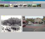
4 Background The dimensions of space and time are fundamental frames for human s perception of a physical area. (Enschede, The Netherlands,1923) (Enschede, The Netherlands,2016) 4

5 5 Hypothesis The combined use of geovisualizations and augmented reality could improve geographical understanding. What is augmented reality (AR)? ICTs: Information and Communication Technologies


6 6 (Mobile) augmented reality(ar) Augmented reality = Augmentation + Reality Device generated contextual data Physical real-world environment Reality camera GPS wireless connectivity accelerometer compass Augmentation Layar Wikitude Example of mobile based AR applications Junaio Aurasma Google Goggles A vast potential to be used in situational education, like geography fieldwork

7 How does augmented reality(ar) work? 7
8 8 Research objectives To design a mobile augmented reality tool (better combined use of geovisualizations and AR) To test the usability of this tool to improve participants spatial and temporal cognition of the fieldwork area and to support teaching and learning during the fieldwork. Scenario: in an educational human geography fieldwork for undergraduates
9 The approach of User-Centered Design (UCD) 9
10 10 User requirement analysis 1. In a real educational human geography fieldwork in China (observation, interview, questionnaire survey) 2. From online survey among UGhent undergraduates Students profile (age, gender, educational background)? How do students and teachers conduct the fieldwork currently? The current problems? Expectations?
11 11 From user requirements to conceptual design The earlier stage of conceptual design is that applying the user requirements to make functional specifications. Summary of user requirements Hardware: smartphone; Android system (first consideration); Collecting various field data (notes, voice, field walking routes); Labeling geo- locations of those field collected data; Optionally viewing various visualizations (street layer, satellite layer, 3D street view, etc.) of the fieldwork area; Group interactions; Location- based contents recommendations; Displaying readable contents on the screens of mobile phones; The user requirements can be abstracted to describe the main functionalities of the tool.


12 12 Components AR browser Mobile maps with street layer, satellite layer Photos, old maps Texts
 with labeling and enable retrieving detailed information (texts, pictures, old maps)")

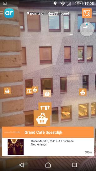
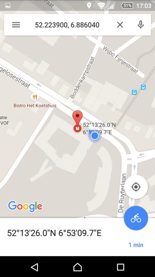
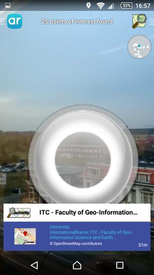
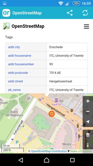
13 13 Functionality descriptions and interfaces In AR view, overlay elements of both points and lines (i.e., roads) with labeling and enable retrieving detailed information (texts, pictures, old maps) in a new interface. In map view, provide Google Maps or OpenStreetMap, with an option to switch among street view, satellite view and 3D view. And display the markers that are also shown in the AR view.
14 14 Functionality descriptions and interfaces Provide input option for users to collect photos and notes as POIs, and display and visualize those collected data in both map view and AR view with markers to indicate that field data is collected in those locations. Click the marker to take photos and notes This is the central building.


15 15 Functionality descriptions and interfaces Provide an export option for users to visualize the collected data in desktop- based Google Maps or OpenStreetMap after the fieldwork


16 16 Functionality descriptions and interfaces Group interaction: sharing locations, photos, sending messages

17 17 Functionality descriptions Offline all the contents of the fieldwork area in advance

18 Future work 18

19 19 Feedback? Suggestions? Functionalities, Interfaces, Development Better support spatial and temporal cognition in geography fieldwork
20 20 Thank you for your attention!
Geo-identification and pedestrian navigation with geo-mobile applications: how do users proceed?
 TU Vienna presentation 17 th July 2008 Geo-identification and pedestrian navigation with geo-mobile applications: how do users proceed? Ioannis Delikostidis Corné van Elzakker INTERNATIONAL INSTITUTE FOR
Geographical Bias on Social Media and Geo-Local Contents System with Mobile Devices
 212 45th Hawaii International Conference on System Sciences Geographical Bias on Social Media and Geo-Local Contents System with Mobile Devices Kazunari Ishida Hiroshima Institute of Technology k.ishida.p7@it-hiroshima.ac.jp
CARTOGRAPHY in a Web World
 CARTOGRAPHY in a Web World Nationale GI Minor BAREND KÖBBEN b.j.kobben@utwente.nl Agenda Short introduction to ITC and me Cartography: communicating spatial data Changing GIS & Cartography technology:
From map use research to usability research in geo-information processing
 Corné van Elzakker From map use research to usability research in geo-information processing INTERNATIONAL INSTITUTE FOR GEO-INFORMATION SCIENCE AND EARTH OBSERVATION International Institute for Geo-Information
Factors that Shape Places Stage 3 Geography
 Factors that Shape Places Stage 3 Geography Summary This unit is written for Stage 3 "Factors that shape places". It is a Geographical Inquiry, enabling students to work through the 3 stages of inquiry;
Research Group Cartography
 Research Group Cartography Research Group Cartography Towards supporting wayfinding LBS components 1. Mobile devices 2. Communication Network 3. Positioning Component 4. Service and Application Provider
CARTOGRAPHY in a Web World
 CARTOGRAPHY in a Web World SENSE Research Cluster XIII meeting: Concepts and tools for spatial data visualization BAREND KÖBBEN kobben@itc.nl b.j.kobben@utwente.nl Agenda Short introduction to ITC and
Your web browser (Safari 7) is out of date. For more security, comfort and. the best experience on this site: Update your browser Ignore
 is out of date. For more security, comfort and. the best experience on this site: Update your browser Ignore") Your web browser (Safari 7) is out of date. For more security, comfort and Activityengage the best experience on this site: Update your browser Ignore Introduction to GIS What is a geographic information
Your web browser (Safari 7) is out of date. For more security, comfort and Activityengage the best experience on this site: Update your browser Ignore Introduction to GIS What is a geographic information
My Map Activity MINNESOTA SOCIAL STUDIES STANDARDS & BENCHMARKS
 My Map Activity OVERVIEW & OBJECTIVES Students will learn the basics of Google Maps while using geospatial data to create their neighborhood map with the places they spend time. They will also collect
Cities in Space and Time: A Spatial-Temporal Visualization Model of Urban Environments
 Cities in Space and Time: A Spatial-Temporal Visualization Model of Urban Environments Li Yin Assistant Professor Department of Urban and Regional Planning University at Buffalo, The State University of
Introduction to Field Data Collection
 Introduction to Field Data Collection Dr. Yuji Murayama (Professor) Dr. Ko Ko Lwin (JSPS Postdoctoral Researcher) Division of Spatial Information Science Graduate School of Life and Environmental Sciences
Planning in a Geospatially Enabled Society. Michael F. Goodchild University of California Santa Barbara
 Planning in a Geospatially Enabled Society Michael F. Goodchild University of California Santa Barbara What is a geospatially enabled society? Knowing the locations of all points of interest and their
Enriching the GIScience Research Agenda: Fusing Augmented Reality (AR) and Location Based Social Networks (LBSN)
 and Location Based Social Networks (LBSN)") Enriching the GIScience Research Agenda: Fusing Augmented Reality (AR) and Location Based Social Networks (LBSN) Chengbi Liu and Sven Fuhrmann Department of Geography and Geoinformation Science George
Enriching the GIScience Research Agenda: Fusing Augmented Reality (AR) and Location Based Social Networks (LBSN) Chengbi Liu and Sven Fuhrmann Department of Geography and Geoinformation Science George
GIScience & Mobility. Prof. Dr. Martin Raubal. Institute of Cartography and Geoinformation SAGEO 2013 Brest, France
 GIScience & Mobility Prof. Dr. Martin Raubal Institute of Cartography and Geoinformation mraubal@ethz.ch SAGEO 2013 Brest, France 25.09.2013 1 www.woodsbagot.com 25.09.2013 2 GIScience & Mobility Modeling
Factors that Shape Places (Blacktown) Stage 3 Geography
 Stage 3 Geography") Factors that Shape Places (Blacktown) Stage 3 Geography Summary This unit is written for Stage 3 "Factors that shape places". It is a Geographical Inquiry, enabling students to work through the 3 stages
Factors that Shape Places (Blacktown) Stage 3 Geography Summary This unit is written for Stage 3 "Factors that shape places". It is a Geographical Inquiry, enabling students to work through the 3 stages
Personal Field Data Collection by UM-FieldGIS (Integration of Google Map API to Mobile GIS)
") Personal Field Data Collection by UM-FieldGIS (Integration of Google Map API to Mobile GIS) Ko Ko Lwin*. Yuji MURAYAMA* *Division of Spatial Information Science Graduate School of Life and Environmental
Personal Field Data Collection by UM-FieldGIS (Integration of Google Map API to Mobile GIS) Ko Ko Lwin*. Yuji MURAYAMA* *Division of Spatial Information Science Graduate School of Life and Environmental
Animating Maps: Visual Analytics meets Geoweb 2.0
 Animating Maps: Visual Analytics meets Geoweb 2.0 Piyush Yadav 1, Shailesh Deshpande 1, Raja Sengupta 2 1 Tata Research Development and Design Centre, Pune (India) Email: {piyush.yadav1, shailesh.deshpande}@tcs.com
Geospatial Visual Analytics and Geovisualization in VisMaster (WP3.4)
") Geospatial Visual Analytics and Geovisualization in VisMaster (WP3.4) Gennady Andrienko Fraunhofer Institute IAIS Sankt Augustin Germany http://geoanalytics.net/and Heidrun Schumann University of Rostock
Geospatial Visual Analytics and Geovisualization in VisMaster (WP3.4) Gennady Andrienko Fraunhofer Institute IAIS Sankt Augustin Germany http://geoanalytics.net/and Heidrun Schumann University of Rostock
Interaction of Mobile Camera Devices with physical maps
 Interaction of Mobile Camera Devices with physical maps Johannes Schöning, Antonio Krüger, Hans Jörg Müller {j.schoening, antonio.krueger, joerg.mueller}@uni-muenster.de Abstract Traditional paper-based
Maps and sustainability
 Maps and sustainability The International Map Year [ mapyear.org ] Menno-Jan Kraak Maps Cartography and maps A map is a visual representation of an environment maps tell stories maps invite maps show patterns
Spatial Knowledge Acquisition in the Context of GPS-based Pedestrian Navigation
 Spatial Knowledge Acquisition in the Context of GPS-based Pedestrian Navigation Haosheng Huang, Manuela Schmidt, Georg Gartner Institute of Geoinformation and Cartography, Vienna University of Technology
Quality of Information collected with the help of Map-Based Questionnaires
 Quality of Information collected with the help of Map-Based Questionnaires Contents 1. Introduction 2. Case Studie: The Switch Project in Wilhelmsburg 3. The Web Platform 1. Technical Architecture 2. Interactive
Google Earth. Overview: Targeted Alaska Grade Level Expectations: Objectives: Materials: Grades 5-8
 Overview: Students become familiar with using the Google Earth interface to navigate around the planet. Using the zoom and tilt features, students practice moving around the planet with the navigation
Koenji. Using ARCGIS Online to explore a place
 Koenji Using ARCGIS Online to explore a place ArcGIS Online is a GIS program that can be opened at http://www.arcgis.com/home/ You can click on Sign-up now or Make a map to get started. It is free to use
2015 Copyright Board of Studies, Teaching and Educational Standards NSW for and on behalf of the Crown in right of the State of New South Wales.
 2015 Copyright Board of Studies, Teaching and Educational Standards NSW for and on behalf of the Crown in right of the State of New South Wales. This document contains Material prepared by the Board of
Techniques for Science Teachers: Using GIS in Science Classrooms.
 Techniques for Science Teachers: Using GIS in Science Classrooms. After ESRI, 2008 GIS A Geographic Information System A collection of computer hardware, software, and geographic data used together for
The Recognition of Temporal Patterns in Pedestrian Behaviour Using Visual Exploration Tools
 The Recognition of Temporal Patterns in Pedestrian Behaviour Using Visual Exploration Tools I. Kveladze 1, S. C. van der Spek 2, M. J. Kraak 1 1 University of Twente, Faculty of Geo-Information Science
ADAPTABLE DASHBOARD FOR VISUALIZATION OF ORIGIN-DESTINATION DATA PATTERNS
 ADAPTABLE DASHBOARD FOR VISUALIZATION OF ORIGIN-DESTINATION DATA PATTERNS Ieva Dobrāja, PhD Candidate Prof. Dr. Menno-Jan Kraak Dr. Yuri Engelhardt NCG Symposium 2017 ADAPTABLE DASHBOARD FOR VISUALIZATION
Geographic Analysis of Linguistically Encoded Movement Patterns A Contextualized Perspective
 Geographic Analysis of Linguistically Encoded Movement Patterns A Contextualized Perspective Alexander Klippel 1, Alan MacEachren 1, Prasenjit Mitra 2, Ian Turton 1, Xiao Zhang 2, Anuj Jaiswal 2, Kean
ADAPTABLE DASHBOARD FOR VISUALIZATION OF ORIGIN-DESTINATION DATA PATTERNS
 ADAPTABLE DASHBOARD FOR VISUALIZATION OF ORIGIN-DESTINATION DATA PATTERNS Ieva Dobrāja, PhD Candidate Prof. Dr. Menno-Jan Kraak Dr. Yuri Engelhardt NCG Symposium 2017 ADAPTABLE DASHBOARD FOR VISUALIZATION
RGI: geo-visualization RGI. The road to. Ron van Lammeren. Centre for Geo-Information 1RL01
 : geo-visualization The road to. Ron van Lammeren 300505 1RL01 Contents Geo-visualisation Types of geo-visualisation Interacting by interfaces Role of geo-visualisation Usability and perception Constructing
Facilitating Survey Sampling in Low- and Middle-Income Contexts Through Satellite Maps and Basic Mobile Computing Technology
 Facilitating Survey Sampling in Low- and Middle-Income Contexts Through Satellite Maps and Basic Mobile Computing Technology 6 th European Survey Association Conference Survey Research in Developing Countries
GIS PORTFOLIO MOHAMED MAGDY MOHAMED HUSSAIN GIS ENGINEER. UWF GIS ONLINE CERTIFICATE GIS Internship (GIS4944)
") 2012 GIS PORTFOLIO MOHAMED MAGDY MOHAMED HUSSAIN GIS ENGINEER UWF GIS ONLINE CERTIFICATE GIS Internship (GIS4944) Portfolio Table of Contents Subject... Page Personal statement/mission/philosophy... 1
2012 GIS PORTFOLIO MOHAMED MAGDY MOHAMED HUSSAIN GIS ENGINEER UWF GIS ONLINE CERTIFICATE GIS Internship (GIS4944) Portfolio Table of Contents Subject... Page Personal statement/mission/philosophy... 1
A Science Center To Go scenario for High Schools: the double slit experiment
 A Science Center To Go scenario for High Schools: the double slit experiment Light and matter are both single entities, and the apparent duality arises in the limitations of our language. Heisenberg Dr.
THE ADVANTAGES OF USING MOBILE GIS TECHNOLOGY
 THE ADVANTAGES OF USING MOBILE GIS TECHNOLOGY F. C. BÂRLIBA 1, I. C. GHEORGHESCU 1, Anca-Maria MOSCOVICI 1 1 Polytechnic University Timișoara, Faculty of Civil Engineering, specialization: Cadastre and
HIGH RESOLUTION BASE MAP: A CASE STUDY OF JNTUH-HYDERABAD CAMPUS
 HIGH RESOLUTION BASE MAP: A CASE STUDY OF JNTUH-HYDERABAD CAMPUS K.Manjula Vani, Abhinay Reddy, J. Venkatesh, Ballu Harish and R.S. Dwivedi ABSTRACT The proposed work High Resolution Base map: A Case study
Using Smartphones and Tablets to introduce Geospatial Data to students
 Using Smartphones and Tablets to introduce Geospatial Data to students Dr Katharine Welsh University of Chester k.welsh@chester.ac.uk Higher Education Network of the Geological Society: Geospatial Technologies
GIS CONCEPTS Part I. GIS ON THE WEB Part II
 Week 2 GIS CONCEPTS Part I GIS ON THE WEB Part II topics of the week part I GIS functions and GIS data Spatial relationships Organizing convention for spatial data Store Information by thematic layers
Online visualization of multi-dimensional spatiotemporal
 Online visualization of multi-dimensional spatiotemporal data Visualization of weather data of Germany in a large time scale Keni Han Final presentation Supervisor: Dr.-Ing. Mathias Jahnke Univ.Prof. Mag.rer.nat.
Participants. Participatory Mapping. Village : Date : Page : / No. Name Job Gender. Entered by. Interviewer. Author. Checked by
 Participatory Mapping Author Interviewer Entered by Checked by Original or Copy O C File name Checked by Has been written on back? Y N Has been copied? Village Participants No. Name Job Gender 1 2 3 4
Lecture 9: Reference Maps & Aerial Photography
 Lecture 9: Reference Maps & Aerial Photography I. Overview of Reference and Topographic Maps There are two basic types of maps? Reference Maps - General purpose maps & Thematic Maps - maps made for a specific
Interactive Visualization Tool (InViTo)
") Interactive Visualization Tool (InViTo) Stefano Pensa To cite this report: Stefano Pensa (2012) Interactive Visualization Tool (InViTo), in Angela Hull, Cecília Silva and Luca Bertolini (Eds.) Accessibility
Interactive Visualization Tool (InViTo) Stefano Pensa To cite this report: Stefano Pensa (2012) Interactive Visualization Tool (InViTo), in Angela Hull, Cecília Silva and Luca Bertolini (Eds.) Accessibility
Geography at Oxford Dr Lorraine Wild
 Open Day 2018 Geography at Oxford Geography at Oxford Dr Lorraine Wild Why is Oxford special? Why is Oxford special? The School of Geography and the Environment has been ranked 1 st in the 2018 QS World
OneStop Map Viewer Navigation
 OneStop Map Viewer Navigation» Intended User: Industry Map Viewer users Overview The OneStop Map Viewer is an interactive map tool that helps you find and view information associated with energy development,
Module Name Module Code
 Module Name Module Code Digital Spatial Analysis - Practical Exercises AEF-EM013 Module Coordinator Dr. agr. Georg Hörmann Organizer Institute for Natural Resource Conservation - Hydrology and Water Resources
Presenting Tree Inventory. Tomislav Sapic GIS Technologist Faculty of Natural Resources Management Lakehead University
 Presenting Tree Inventory Tomislav Sapic GIS Technologist Faculty of Natural Resources Management Lakehead University Suggested Options 1. Print out a Google Maps satellite image of the inventoried block
Looking at Communities: Comparing Urban and Rural Neighborhoods
 Looking at Communities: Comparing Urban and Rural Neighborhoods OVERVIEW & OBJECTIVES Our urban areas have become so dominant that frequently the children we teach have no connection with and very few
Course Syllabus. Geospatial Data & Spatial Digital Technologies: Assessing Land Use/Land Cover Change in the Ecuadorian Amazon.
 Course Syllabus Geospatial Data & Spatial Digital Technologies: Assessing Land Use/Land Cover Change in the Ecuadorian Amazon Co- Instructors Dr. Carlos F. Mena, Universidad San Francisco de Quito, Ecuador
STAGE 2 GEOGRAPHY: Natural environments
 STAGE 2 GEOGRAPHY: Natural environments Focus area: The Earth s environment Different environments Significance of environments Key inquiry questions How does the environment support the lives of people
Cartographic visualisation of Time
 Cartographic visualisation of Time prof Menno-Jan Kraak Barend Köbben INTERNATIONAL INSTITUTE FOR GEO-INFORMATION SCIENCE AND EARTH OBSERVATION Contents Changing Cartography
Write a report (6-7 pages, double space) on some examples of Internet Applications. You can choose only ONE of the following application areas:
 on some examples of Internet Applications. You can choose only ONE of the following application areas:") UPR 6905 Internet GIS Homework 1 Yong Hong Guo September 9, 2008 Write a report (6-7 pages, double space) on some examples of Internet Applications. You can choose only ONE of the following application
UPR 6905 Internet GIS Homework 1 Yong Hong Guo September 9, 2008 Write a report (6-7 pages, double space) on some examples of Internet Applications. You can choose only ONE of the following application
Introduction to GIS (GEOG 401) Spring 2014, 3 credit hours
 Spring 2014, 3 credit hours") Introduction to GIS (GEOG 401) Spring 2014, 3 credit hours Instructors: Guangxing Wang, Ph.D. Email: gxwang@siu.edu Phone: (618) 453-6017 Office: 4442 Faner Hall Office hours: M& W&F 9:00am-11:00am or
Introduction to GIS (GEOG 401) Spring 2014, 3 credit hours Instructors: Guangxing Wang, Ph.D. Email: gxwang@siu.edu Phone: (618) 453-6017 Office: 4442 Faner Hall Office hours: M& W&F 9:00am-11:00am or
GIS Visualization: A Library s Pursuit Towards Creative and Innovative Research
 GIS Visualization: A Library s Pursuit Towards Creative and Innovative Research Justin B. Sorensen J. Willard Marriott Library University of Utah justin.sorensen@utah.edu Abstract As emerging technologies
Geography Curriculum Overview
 Geography Curriculum Overview 2016-2017 Suggest one topic a year for each year group based on another city/country or possible local. Suggested ideas for some year groups have been put in as they will
Chemistry Laboratory Equipment Inventory Media: An Alternative Media for Students in Learning of Laboratory Management
 Chemistry Laboratory Equipment Inventory Media: An Alternative Media for Students in Learning of Laboratory Management E. Priyambodo 1*, A. Wiyarsi 2, Dina 3, A.R.E. Nugraheni 4 1, 2, 3, 4 Department of
Development and operation of GIS exercise materials for undergraduate students
 Development and operation of GIS exercise materials for undergraduate students Since around 2000, GIS researchers in Japan have collaborated to provide materials for GIS lecture classes for university
Conceptual study of Web-based PPGIS for Designing Built Environment: Identifying Housing Location Preferences in Littleborough
 Conceptual study of Web-based PPGIS for Designing Built Environment: Identifying Housing Location Preferences in Littleborough Shrabanti Hira *1, S M Labib 1 1 SEED, University of Manchester March 31,
Exploring Potential Human Activities in Physical and Virtual Spaces: A Spatio-temporal temporal GIS Approach
 Exploring Potential Human Activities in Physical and Virtual Spaces: A Spatio-temporal temporal GIS Approach Hongbo Yu Department of Geography, The University of Tennessee Knoxville, TN 37996-0925, USA
Conceptual Aspects of 3D Map Integration in Interactive School Atlases
 Conceptual Aspects of 3D Map Integration in Interactive School Atlases Christian Haeberling Hans Rudolf Baer Institute of Cartography ETH Zurich 8093 Zurich, Switzerland E-Mail: haeberling@karto.baug.ethz.ch
Will this program be printed in the Bulletin? Yes No
 NEW UNDERGRADUATE MINOR / CHANGE UNDERGRADUATE MINOR FORM Please fill out Section I. SECTION I: GENERAL INFORMATION Program: GEO Minor: Geography College: A&S Department: Geography Bulletin PP: 135 CIP
You are Building Your Organization s Geographic Knowledge
 You are Building Your Organization s Geographic Knowledge And Increasingly Making it Available Sharing Data Publishing Maps and Geo-Apps Developing Collaborative Approaches Citizens Knowledge Workers Analysts
A thesis submitted in fulfillment of the requirements. for the degree of Master of Science in Geospatial Technologies.
 AUGMENTING PEDESTRIAN NAVIGATION SYSTEMS WITH CONTEXT-AWARE DISPLAY OF POIS A thesis submitted in fulfillment of the requirements for the degree of Master of Science in Geospatial Technologies in the GEOTEC
MobileMapper 6. White Paper. MobileMapper 6 vs. Juno SC In Real World Conditions. Sub-Meter, Post-Processed Accuracy for less than 1,500 USD
 MobileMapper 6 White Paper MobileMapper 6 vs. Juno SC In Real World Conditions Sub-Meter, Post-Processed Accuracy for less than 1,500 USD Table of Contents Introduction...1 Testing Methodology...2 Test
2013 AND 2025 THE FUTURE OF GIS
 THE FUTURE OF GIS 2013 AND 2025 What is the state of geospatial computing today? What are the issues today? Unresolved problems What will geospatial computing be like in 2025? What issues will be of concern
CALIOPE EU: Air Quality
 CALIOPE EU: Air Quality CALIOPE EU air quality forecast application User Guide caliope@bsc.es Version 30/09/2015 TABLE OF CONTENTS 1. Description... 1 2. Installation... 1 3. User Guide... 2 3.1 Air quality
Diffusion of GIS in Public Policy Doctoral Program
 Diffusion of GIS in Public Policy Doctoral Program By Fulbert Namwamba PhD Southern University This presentation demonstrate how GIS was introduced in the Public Policy Doctoral Program at Southern University,
GEOGRAPHIC INFORMATION SYSTEMS Session 8
 GEOGRAPHIC INFORMATION SYSTEMS Session 8 Introduction Geography underpins all activities associated with a census Census geography is essential to plan and manage fieldwork as well as to report results
Augmented Reality Challenges Frameworks and Open Standards. Michael Zöllner Fraunhofer IGD ARE June 2010
 Augmented Reality Challenges Frameworks and Open Standards Michael Zöllner Fraunhofer IGD ARE2010 02 June 2010 » Evolution of Augmented Reality for Cultural Heritage«Fraunhofer IGD / Michael Zöllner /
SADA General Information
 SADA General Information Windows--based freeware designed to integrate scientific models with decision and cost analysis frameworks in a seamless, easy to use environment. Visualization/GIS Custom Analysis
Research into the Usability of the Space-Time Cube
 Research into the Usability of the Space-Time Cube Irma Kveladze, Menno-Jan Kraak, Corné van Elzakker University of Twente, Faculty of Geo-Information Science and Earth Observation (ITC), The Netherlands
Crime Analyst Extension. Christine Charles
 Crime Analyst Extension Christine Charles ccharles@esricanada.com Agenda Why use Crime Analyst? Overview Tools Demo Interoperability With our old software it could take a police officer up to forty minutes
Geospatial Services in Special Libraries: A Needs Assessment Perspective
 Purdue University Purdue e-pubs Libraries Faculty and Staff Scholarship and Research Purdue Libraries 5-17-2013 Geospatial Services in Special Libraries: A Needs Assessment Perspective Ilana R. Barnes
Volume Editor. Hans Weghorn Faculty of Mechatronics BA-University of Cooperative Education, Stuttgart Germany
 Volume Editor Hans Weghorn Faculty of Mechatronics BA-University of Cooperative Education, Stuttgart Germany Proceedings of the 4 th Annual Meeting on Information Technology and Computer Science ITCS,
Using Web Maps to Measure the Development of Global Scale Cognitive Maps
 Using Web Maps to Measure the Development of Global Scale Cognitive Maps Thomas J. Pingel Department of Geography Northern Illinois University Illinois Geographic Information Systems Association (ILGISA)
name and locate the world s seven continents and five oceans
 Subject: Geography Activities National Curriculum Objectives One Progression of Skills Name the 7 continents and 5 oceans 3D Jigsaw task to locate continents and seas name and locate the world s seven
Geo Business Gis In The Digital Organization
 We have made it easy for you to find a PDF Ebooks without any digging. And by having access to our ebooks online or by storing it on your computer, you have convenient answers with geo business gis in
Overview. Everywhere. Over everything.
 Cadenza Desktop Cadenza Web Cadenza Mobile Cadenza Overview. Everywhere. Over everything. The ultimate GIS and reporting suite. Provide, analyze and report data efficiently. For desktop, web and mobile.
One platform for desktop, web and mobile
 One platform for desktop, web and mobile Search and filter Get access to all data thematically filter data in context factually and spatially as well as display it dynamically. Export a selection or send
Develop a Spatial Information Management System: A Case Study for Faculty of Agriculture, University of Ruhuna, Sri Lanka
 Develop a Spatial Information Management System: A Case Study for Faculty of Agriculture, University of Ruhuna, Sri Lanka Prabath Priyankara 1*, Upul Indika 2 and Dimuthu Piyaratne 1 1 Computer Unit, Faculty
Cognitive Engineering for Geographic Information Science
 Cognitive Engineering for Geographic Information Science Martin Raubal Department of Geography, UCSB raubal@geog.ucsb.edu 21 Jan 2009 ThinkSpatial, UCSB 1 GIScience Motivation systematic study of all aspects
Smart Data Collection and Real-time Digital Cartography
 Smart Data Collection and Real-time Digital Cartography Yuji Murayama and Ko Ko Lwin Division of Spatial Information Science Faculty of Life and Environmental Sciences University of Tsukuba IGU 2013 1
Subject: Geography Unit 1: The Earth
 Subject: Geography Unit 1: The Earth Learning outcomes Activities Resources Thinking Skills Language of Learning The earth s relief and its different forms such as mountains, valleys, plains. The parts
Three-Dimensional Visualization of Activity-Travel Patterns
 C. Rinner 231 Three-Dimensional Visualization of Activity-Travel Patterns Claus Rinner Department of Geography University of Toronto, Canada rinner@geog.utoronto.ca ABSTRACT Geographers have long been
Arboretum Explorer: Using GIS to map the Arnold Arboretum
 Arboretum Explorer: Using GIS to map the Arnold Arboretum Donna Tremonte, Arnold Arboretum of Harvard University 2015 Esri User Conference (UC), July 22, 2015 http://arboretum.harvard.edu/explorer Mission
GPS Mapping with Esri s Collector App. What We ll Cover
 GPS Mapping with Esri s Collector App Part 1: Overview What We ll Cover Part 1: Overview and requirements Part 2: Preparing the data in ArcGIS for Desktop Part 3: Build a web map in ArcGIS Online Part
Extracting mobility behavior from cell phone data DATA SIM Summer School 2013
 Extracting mobility behavior from cell phone data DATA SIM Summer School 2013 PETER WIDHALM Mobility Department Dynamic Transportation Systems T +43(0) 50550-6655 F +43(0) 50550-6439 peter.widhalm@ait.ac.at
Geodatabases and ArcCatalog
 Geodatabases and ArcCatalog Francisco Olivera, Ph.D., P.E. Srikanth Koka Lauren Walker Aishwarya Vijaykumar Keri Clary Department of Civil Engineering April 21, 2014 Contents Geodatabases and ArcCatalog...
Sample assessment task. Task details. Content description. Year level 7
 Sample assessment task Year level 7 Learning area Subject Title of task Task details Description of task Type of assessment Purpose of assessment Assessment strategy Evidence to be collected Suggested
Investigating Weather and Climate with Google Earth Teacher Guide
 Google Earth Weather and Climate Teacher Guide In this activity, students will use Google Earth to explore global temperature changes. They will: 1. Use Google Earth to determine how the temperature of
Give 4 advantages of using ICT in the collection of data. Give. Give 4 disadvantages in the use of ICT in the collection of data
 Give 4 advantages of using ICT in the collection of data can use a handheld GPS to get accurate location information which can be used to show data linked to specific locations within a GIS can collect
Augmented Reality Market Research Report- Global Forecast till 2023
 Report Information More information from: https://www.marketresearchfuture.com/reports/1143 Augmented Reality Market Research Report- Global Forecast till 2023 Report / Search Code: MRFR/ICT/0637-HCRR
Search for the Gulf of Carpentaria in the remap search bar:
 This tutorial is aimed at getting you started with making maps in Remap (). In this tutorial we are going to develop a simple classification of mangroves in northern Australia. Before getting started with
Collection and Analyses of Crowd Travel Behaviour Data by using Smartphones
 Collection and Analyses of Crowd Travel Behaviour Data by using Smartphones Rik Bellens 1 Sven Vlassenroot 2 Sidharta Guatama 3 Abstract: In 2010 the MOVE project started in the collection and analysis
Your web browser (Safari 7) is out of date. For more security, comfort and the best experience on this site: Update your browser Ignore
 is out of date. For more security, comfort and the best experience on this site: Update your browser Ignore") Your web browser (Safari 7) is out of date. For more security, comfort and the best experience on this site: Update your browser Ignore Activityapply MEASU RING DISTANCES O N A MAP How can you use a map
Your web browser (Safari 7) is out of date. For more security, comfort and the best experience on this site: Update your browser Ignore Activityapply MEASU RING DISTANCES O N A MAP How can you use a map
Using Active Learning in Conductometric Titration
 CHE-OR-01 Using Active Learning in Conductometric Titration Pimchana Hoktha Department of Chemistry, Faculty of Science, Thaksin University, Pattalung 93110, Thailand E-mail: hoktha@gmail.com Active learning
Your web browser (Safari 7) is out of date. For more security, comfort and the best experience on this site: Update your browser Ignore
 is out of date. For more security, comfort and the best experience on this site: Update your browser Ignore") Your web browser (Safari 7) is out of date. For more security, comfort and the best experience on this site: Update your browser Ignore Activitydevelop EXPLO RE CARDINAL DIRECTIO NS What do cardinal directions
Your web browser (Safari 7) is out of date. For more security, comfort and the best experience on this site: Update your browser Ignore Activitydevelop EXPLO RE CARDINAL DIRECTIO NS What do cardinal directions
Introduction To A New Geo-Referenced Street Level Content: 3D GEOPANO
 Free and Open Source Software for Geospatial (FOSS4G) Conference Proceedings Volume 15 Seoul, South Korea Article 10 2015 Introduction To A New Geo-Referenced Street Level Content: 3D GEOPANO Boram Yoon
Using the FCMQ`s snowmobile trail interactive map
 Using the FCMQ`s snowmobile trail interactive map Recommended browsers: Google Chrome, Mozilla Firefox or Internet Explorer 10 or newer. The interactive map is compatible with any type of mobile device
Esri Overview for Mentor Protégé Program:
 Agenda Passionate About Helping You Succeed Esri Overview for Mentor Protégé Program: Northrop Grumman CSSS Jeff Dawley 3 September 2010 Esri Overview ArcGIS as a System ArcGIS 10 - Map Production - Mobile
Esri Defense Mapping: Cartographic Production. Bo King
 Esri Defense Mapping: Cartographic Production Bo King Agenda Esri Defense Mapping: Cartographic Production Solution Overview Desktop Cartographic Production Workflow - Create Rapid Graphic Product On Demand