Social and Technological Network Analysis: Spatial Networks, Mobility and Applications
|
|
|
- Abel Smith
- 5 years ago
- Views:
Transcription
1 Social and Technological Network Analysis: Spatial Networks, Mobility and Applications Anastasios Noulas Computer Laboratory, University of Cambridge February 2015

2 Today s Outline 1. Introduction to spatial networks 2. Geo-social networks 3. Location-based social networks 4. Special: Spatial economics & the sharing economy
3 What is a spatial network A spatial network is a graph whose nodes are embedded in a metric space. Hence, in spatial networks, one can apply a distance function between two nodes in the network. The distance metric used to analyse spatial networks is often geographic distance. Can you think of any spatial networks emerging in the real world?

4 Spatial Networks
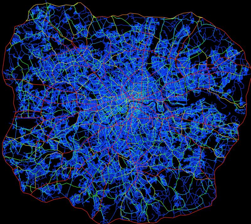
5 Spatial Networks

6 Spatial Networks
7 Spatial networks Planar networks: networks that can be drawn in a manner so that edges do not intersect (e.g. transport: rail networks, road networks etc.) Non-planar: airline networks, networks of social relationships. Swiss Rail Spatial Networks by Marc Berthelemy

8

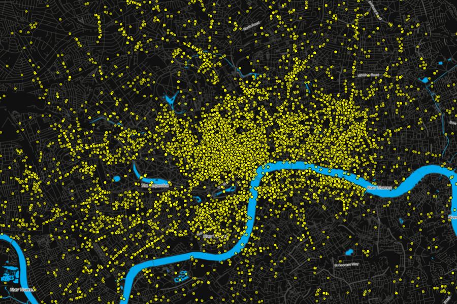
9 Network of places in New York City special thanks to Blake Foursquare

10 Geo-social networks Geo-social networks are social networks embedded in geographic space. Geography and network topology are key to network s function and evolution.


11 Location is everywhere

12 Location-based social networks Mobile services that are focused (based) on places. Users check in to places & connect with friends. A social network is formed above real world places. Popular in urban environments.
13 Location-based social networks Socio-spatial properties of Online Location-based Social Networks, Scellato et al, ICWSM 2011.
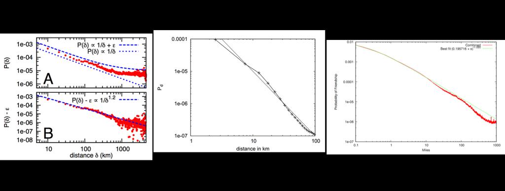
14 Location-based social networks Link length distribution: friends vs random user pairs. Probability of friendship as a function of geographic distance.
15 Location-based social networks geo model: wire nodes based on distance. social model: shuffle nodes geographic location. Geographic distance or social connectivity alone cannot explain data!

16 Location-based social networks gravity model: attraction proportional to the degree of target node and repulsion proportional to distance. Alamanis et. al, ICM

17 Friendship and geographic distance Friendship as a function of distance in Livejournal. Geographic routing in social networks Liben-Nowell et. al, PNAS 2005

18 Friendship and geographic distance Variations in population densities and friendship probability over geographic distance. Geographic routing in social networks Liben-Nowell et. al, PNAS 2005
19 Defining Rank-Distance

20 Rank universality Geographic routing in social networks Liben-Nowell et. al, PNAS 2005
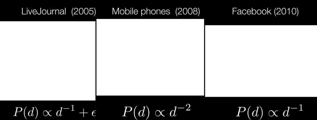
21 Friendship & distance across services
22

23 Samuel A. Stouffer Stouffer's law of intervening opportunities states, "The number of persons going a given distance is directly proportional to the number of opportunities at that distance and inversely proportional to the number of intervening opportunities." * - Empirically proven using data for migrating families in the city of Cleveland. - We investigate the plausibility of the theory for urban movements in Foursquare. * S. Stouffer (1940) Intervening opportunities: A theory relating mobility and distance, American Sociological Review 5,
24 The importance of density Density [Places/km 2 ] x Mean Transition [km] Area [km 2 ] Mean Transition [km] - Stouffer s Theory of Intervening Opportunities motivated us to inspect the impact of places(=opportunities) in human mobility. - Place density by far more important than the city area size with respect to mean length of human movements (R 2 = 0.59 and 0.19 respectively).
25 Rank universality PDF three cities SINGAPORE HOUSTON SAN FRANCISCO 0.24(x) RANK PDF The rank of all cities collapse to a single line. HOUSTON SAN FRANCISCO SINGAPORE urban all cities Distance RANK [km] We have measured a power law exponent α = 0.84 ± 0.07


26 new model for urban mobility soil... and mind!
27 Simulation Results...


28 The importance of Geography Heterogeneities observed in human mobility is due to geographic variations. Cultural, organisational or other factors do not appear to play a role in urban movements. The rank model, although simple, can cope with the complex spatial variations in densities observed in urban environments.

29 Location is not here for fun! A big problem for locationbased services is how to monetise. There are a host of potential revenue channels (venue claim, geo ads, data sales..) New location-centric services emerge and old ones constantly transform.

30 GEO SPOTTING
31 Starbucks Dunkin Donuts McDonald s CDF Transition Distance, km Relatively speaking... McDonald s tend to pull check-ins from remote locations whereas Dunkin and Starbucks attract local movements.
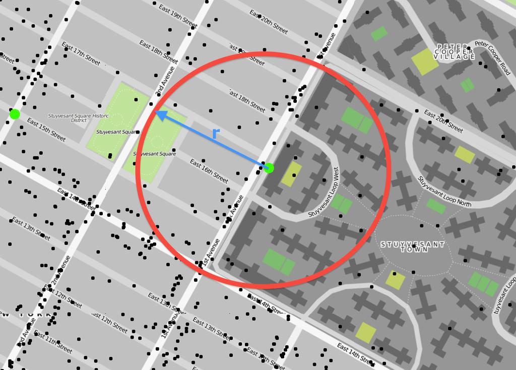
32 Exploit place type networks for retail area quality assessment Intuition: certain place types attract each other (e.g. coffee shops at train stations) Application: Can we exploit spatial, place-type configuration patterns to assess the retail quality of an area? Pablo Jensen PRL E, 2006,
33 Methodology for extracting the Jensen (retail) quality of an area. site 1, site 2... site M Step 1: Measure the frequency of a place type across all M sites. This can be checked for a city, a country or the locations of a chain depending on the goal of the application. Below is the normed frequency of category B: N_B/N_tot Step 2: To measure the attractiveness of a category (place type) B towards another type A do the following: iterate across all sites of A, retrieve the nearby places within a radius r, and measure the number of occurrences of B, n_b and its ratio with respect to all nearby places n_b/n_tot. B 200m x B A x x B B x Step 3: Finally, measure for a given place type A, the average attractiveness score, M_AB, defined below. Effectively, you are measuring the chance of observing B next to A, over observing B at a random location. M_AB = <n_b/n_tot> N_B/N_tot
34


35 colocation Does colocation imply movement? mobility

36 THE APP: EVERYONE S PRIVATE DRIVER
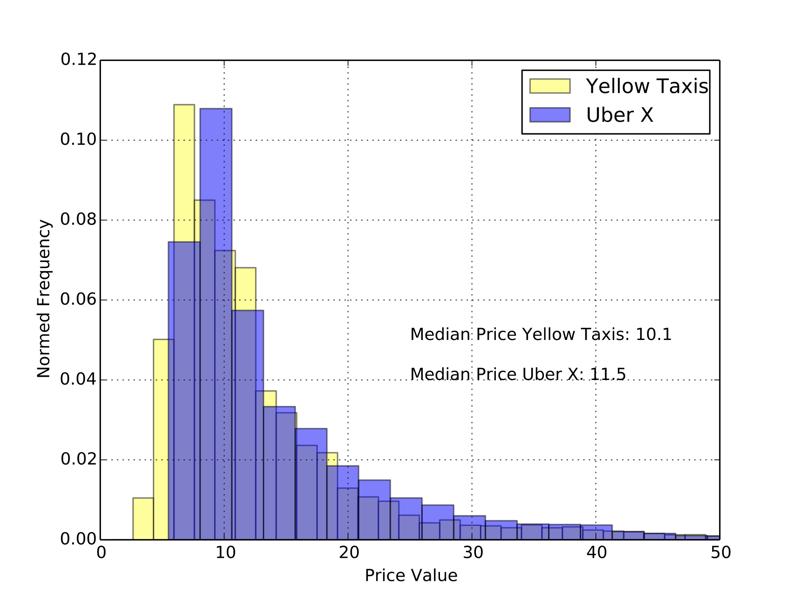
37 THE NEW YORK CITY TAXI DATASET FOILing NYC s Taxi Trip Data Freedom of Information Law 2013 Trip Data, 11GB, zipped! 2013 Fare Data, 7.7GB Idea: Uber Vs Yellow Taxi Price Comparison.
38
39 uber more expensive for short trips

40 AN APP TO REDUCE COMMUTER COSTS Provide feedback on prices to users Collect more data for research Make cities smarter

41 Questions?
Social and Technological Network Analysis. Lecture 11: Spa;al and Social Network Analysis. Dr. Cecilia Mascolo
 Social and Technological Network Analysis Lecture 11: Spa;al and Social Network Analysis Dr. Cecilia Mascolo In This Lecture In this lecture we will study spa;al networks and geo- social networks through
arxiv: v1 [cs.si] 7 Jun 2013
![arxiv: v1 [cs.si] 7 Jun 2013](/thumbs/90/102443694.jpg "arxiv: v1 [cs.si] 7 Jun 2013") Geo-Spotting: Mining Online Location-based Services for Optimal Retail Store Placement arxiv:1306.1704v1 [cs.si] 7 Jun 2013 Dmytro Karamshuk 1, Anastasios Noulas 2, Salvatore Scellato 2, Vincenzo Nicosia
Geo-Spotting: Mining Online Location-based Services for Optimal Retail Store Placement arxiv:1306.1704v1 [cs.si] 7 Jun 2013 Dmytro Karamshuk 1, Anastasios Noulas 2, Salvatore Scellato 2, Vincenzo Nicosia
Socio-spatial Properties of Online Location-based Social Networks
 Socio-spatial Properties of Online Location-based Social Networks Salvatore Scellato Computer Laboratory University of Cambridge salvatore.scellato@cam.ac.uk Renaud Lambiotte Deparment of Mathematics Imperial
Putting the U.S. Geospatial Services Industry On the Map
 Putting the U.S. Geospatial Services Industry On the Map December 2012 Definition of geospatial services and the focus of this economic study Geospatial services Geospatial services industry Allow consumers,
Exploiting Geographic Dependencies for Real Estate Appraisal
 Exploiting Geographic Dependencies for Real Estate Appraisal Yanjie Fu Joint work with Hui Xiong, Yu Zheng, Yong Ge, Zhihua Zhou, Zijun Yao Rutgers, the State University of New Jersey Microsoft Research
Friendship and Mobility: User Movement In Location-Based Social Networks. Eunjoon Cho* Seth A. Myers* Jure Leskovec
 Friendship and Mobility: User Movement In Location-Based Social Networks Eunjoon Cho* Seth A. Myers* Jure Leskovec Outline Introduction Related Work Data Observations from Data Model of Human Mobility
Point-of-Interest Recommendations: Learning Potential Check-ins from Friends
 Point-of-Interest Recommendations: Learning Potential Check-ins from Friends Huayu Li, Yong Ge +, Richang Hong, Hengshu Zhu University of North Carolina at Charlotte + University of Arizona Hefei University
Urban characteristics attributable to density-driven tie formation
 Supplementary Information for Urban characteristics attributable to density-driven tie formation Wei Pan, Gourab Ghoshal, Coco Krumme, Manuel Cebrian, Alex Pentland S-1 T(ρ) 100000 10000 1000 100 theory
SMALL-WORLD NAVIGABILITY. Alexandru Seminar in Distributed Computing
 SMALL-WORLD NAVIGABILITY Talk about a small world 2 Zurich, CH Hunedoara, RO From cliché to social networks 3 Milgram s Experiment and The Small World Hypothesis Omaha, NE Boston, MA Wichita, KS Human
Big Data Discovery and Visualisation Insights for ArcGIS
 Big Data Discovery and Visualisation Insights for ArcGIS Create Enrich - Collaborate Lee Kum Cheong GIS CONVERSATIONS At Esri, we believe people can do amazing things with applied geography. GIS CONVERSATIONS
Greedy Search in Social Networks
 Greedy Search in Social Networks David Liben-Nowell Carleton College dlibenno@carleton.edu Joint work with Ravi Kumar, Jasmine Novak, Prabhakar Raghavan, and Andrew Tomkins. IPAM, Los Angeles 8 May 2007
Key Issue 1: Where Are Services Distributed?
 Key Issue 1: Where Are Services Distributed? Pages 430-433 *See the Introduction on page 430 to answer questions #1-4 1. Define service: 2. What sector of the economy do services fall under? 3. Define
Lecture 19: Common property resources
 Lecture 19: Common property resources Economics 336 Economics 336 (Toronto) Lecture 19: Common property resources 1 / 19 Introduction Common property resource: A resource for which no agent has full property
MOR CO Analysis of future residential and mobility costs for private households in Munich Region
 MOR CO Analysis of future residential and mobility costs for private households in Munich Region The amount of the household budget spent on mobility is rising dramatically. While residential costs can
Methodological issues in the development of accessibility measures to services: challenges and possible solutions in the Canadian context
 Methodological issues in the development of accessibility measures to services: challenges and possible solutions in the Canadian context Alessandro Alasia 1, Frédéric Bédard 2, and Julie Bélanger 1 (1)
Exploring the Patterns of Human Mobility Using Heterogeneous Traffic Trajectory Data
 Exploring the Patterns of Human Mobility Using Heterogeneous Traffic Trajectory Data Jinzhong Wang April 13, 2016 The UBD Group Mobile and Social Computing Laboratory School of Software, Dalian University
The Trade Area Analysis Model
 The Trade Area Analysis Model Trade area analysis models encompass a variety of techniques designed to generate trade areas around stores or other services based on the probability of an individual patronizing
Combining Geographic and Network Analysis: The GoMore Rideshare Network. Kate Lyndegaard
 Combining Geographic and Network Analysis: The GoMore Rideshare Network Kate Lyndegaard 10.15.2014 Outline 1. Motivation 2. What is network analysis? 3. The project objective 4. The GoMore network 5. The
E n t r y : B e s t I n n o v a t i o n i n h o t e l c o n c e p t. i b i s H o t e l s : R e i n v e n t i n g t h e G u e s t E x p e r i e n c e
 E n t r y : B e s t I n n o v a t i o n i n h o t e l c o n c e p t i b i s H o t e l s : R e i n v e n t i n g t h e G u e s t E x p e r i e n c e T h e C o n c e p t In 2017, Ibis Hotels introduced a
Exploring spatial decay effect in mass media and social media: a case study of China
 Exploring spatial decay effect in mass media and social media: a case study of China 1. Introduction Yihong Yuan Department of Geography, Texas State University, San Marcos, TX, USA, 78666. Tel: +1(512)-245-3208
Designing smart & Resilient cities:
 Designing smart & Resilient cities: How can Egyptian cities learn from an emerging global practice On the Cuspof Change Professor Samer Bagaeen FRICS MRTPI FRSA AoU 1. GLOBAL CHALLENGES POPULATION GROWTH,
Which diversity in the hierarchical organisation of urban systems in Europe?
 Which diversity in the hierarchical organisation of urban systems in Europe? Denise Pumain Université Paris I, UMR Géographie-cités Céline Rozenblat Université de Lausanne 1 A geographical ontology of
CIV3703 Transport Engineering. Module 2 Transport Modelling
 CIV3703 Transport Engineering Module Transport Modelling Objectives Upon successful completion of this module you should be able to: carry out trip generation calculations using linear regression and category
Introduction to Economic Geography
 Introduction to Economic Geography Globalization, Uneven Development and Place 2nd edition Danny MacKinnon and Andrew Cumbers Harlow, England London New York Boston San Francisco Toronto Sydney Singapore
Can Public Transport Infrastructure Relieve Spatial Mismatch?
 Can Public Transport Infrastructure Relieve Spatial Mismatch? Evidence from Recent Light Rail Extensions Kilian Heilmann University of California San Diego April 20, 2015 Motivation Paradox: Even though
High speed network in Hauts-de-France Region. Värnamo, 17 th May 2018
 High speed network in Hauts-de-France Region Värnamo, 17 th May 2018 Hauts-de-France at the crossroads of the North-West Europe High speed train approach in France In the 1980s: will to link the main cities
ENV208/ENV508 Applied GIS. Week 1: What is GIS?
 ENV208/ENV508 Applied GIS Week 1: What is GIS? 1 WHAT IS GIS? A GIS integrates hardware, software, and data for capturing, managing, analyzing, and displaying all forms of geographically referenced information.
With examples from URSPIC and SINGOCOM
 Work in Progress: please do not quote or distribute without permission. Operationalising holism in social exclusion and innovation analysis. With examples from URSPIC and SINGOCOM Frank Moulaert Outline
Policy Note 6. Measuring Unemployment by Location and Transport: StepSA s Access Envelope Technologies
 6 Measuring Unemployment by Location and Transport: StepSA s Access Envelope Technologies Introduction Increasing emphasis is coming onto spatial planning as government in South Africa moves to address
Identifying Megaregions in the US: Implications for Infrastructure Investment
 7. 10. 2 0 08 Identifying Megaregions in the US: Implications for Infrastructure Investment Dr. Myungje Woo Dr. Catherine L. Ross Jason Barringer Harry West Jessica Lynn Harbour Doyle Center for Quality
Diagnosing New York City s Noises with Ubiquitous Data
 Diagnosing New York City s Noises with Ubiquitous Data Dr. Yu Zheng yuzheng@microsoft.com Lead Researcher, Microsoft Research Chair Professor at Shanghai Jiao Tong University Background Many cities suffer
MULTIPLE CHOICE. Choose the one alternative that best completes the statement or answers the question.
 AP Test 13 Review Name MULTIPLE CHOICE. Choose the one alternative that best completes the statement or answers the question. 1) Compared to the United States, poor families in European cities are more
The spatial network Streets and public spaces are the where people move, interact and transact
 The spatial network Streets and public spaces are the where people move, interact and transact The spatial network Cities are big spatial networks that create more of these opportunities Five key discoveries
Spatial Data, Spatial Analysis and Spatial Data Science
 Spatial Data, Spatial Analysis and Spatial Data Science Luc Anselin http://spatial.uchicago.edu 1 spatial thinking in the social sciences spatial analysis spatial data science spatial data types and research
CLAREMONT MASTER PLAN 2017: LAND USE COMMUNITY INPUT
 Planning and Development Department 14 North Street Claremont, New Hampshire 03743 Ph: (603) 542-7008 Fax: (603) 542-7033 Email: cityplanner@claremontnh.com www.claremontnh.com CLAREMONT MASTER PLAN 2017:
Trip Distribution Modeling Milos N. Mladenovic Assistant Professor Department of Built Environment
 Trip Distribution Modeling Milos N. Mladenovic Assistant Professor Department of Built Environment 25.04.2017 Course Outline Forecasting overview and data management Trip generation modeling Trip distribution
ITC. Regional and Urban Planning ITC Department
 COMBINING SPACE SYNTAX AND LOCATION BASED ACCESSIBILITY TO MODEL URBAN LAND VALUES CASE STUDY: GUATEMALA Andres Morales, Johannes Flacke, Javier Morales, Jaap Zevenbergen S Regional and Urban Planning
Unit 2 - Globalization: Distance, Transportation, and Spatial Interaction
 Unit 2 - Globalization: Distance, Transportation, and Spatial Interaction 38:180 Human Geography Spatial Interaction The friction of distance Underlies locational patterns (e.g. residential patterns, location
Application of GIS in Public Transportation Case-study: Almada, Portugal
 Case-study: Almada, Portugal Doutor Jorge Ferreira 1 FSCH/UNL Av Berna 26 C 1069-061 Lisboa, Portugal +351 21 7908300 jr.ferreira@fcsh.unl.pt 2 FSCH/UNL Dra. FCSH/UNL +351 914693843, leite.ines@gmail.com
Texas A&M University
 Texas A&M University CVEN 658 Civil Engineering Applications of GIS Hotspot Analysis of Highway Accident Spatial Pattern Based on Network Spatial Weights Instructor: Dr. Francisco Olivera Author: Zachry
Topic 4: Changing cities
 Topic 4: Changing cities Overview of urban patterns and processes 4.1 Urbanisation is a global process a. Contrasting trends in urbanisation over the last 50 years in different parts of the world (developed,
Anoka Hennepin K 12 Curriculum Unit Plan
 Anoka Hennepin K 12 Curriculum Unit Plan Department: Social Studies Grade Level: 4 Unit Title: Geographic Investigations Trimester: 2 and 3 (16) 55 minute lessons (can be (32) 25 minute lessons) Unit Summary:
CORRIDORS OF FREEDOM Access Management (Ability) Herman Pienaar: Director City Transformation and Spatial Planning
 Herman Pienaar: Director City Transformation and Spatial Planning") CORRIDORS OF FREEDOM Access Management (Ability) 2016 Herman Pienaar: Director City Transformation and Spatial Planning PLANNING DEVELOPMENT PROCESS RATHER THAN A PLAN CAPITAL INVESTMENT DEVELOPMENT FACILITATION
CORRIDORS OF FREEDOM Access Management (Ability) 2016 Herman Pienaar: Director City Transformation and Spatial Planning PLANNING DEVELOPMENT PROCESS RATHER THAN A PLAN CAPITAL INVESTMENT DEVELOPMENT FACILITATION
Urban Growth and Transportation Development Patterns for China s Urban Transition
 Urban Growth and Transportation Development Patterns for China s Urban Transition Qisheng Pan Professor and Chair, Department of Urban Planning and Environmental Policy, Texas Southern University President,
Activity Identification from GPS Trajectories Using Spatial Temporal POIs Attractiveness
 Activity Identification from GPS Trajectories Using Spatial Temporal POIs Attractiveness Lian Huang, Qingquan Li, Yang Yue State Key Laboratory of Information Engineering in Survey, Mapping and Remote
BROOKINGS May
 Appendix 1. Technical Methodology This study combines detailed data on transit systems, demographics, and employment to determine the accessibility of jobs via transit within and across the country s 100
Estimating Transportation Demand, Part 2
 Transportation Decision-making Principles of Project Evaluation and Programming Estimating Transportation Demand, Part 2 K. C. Sinha and S. Labi Purdue University School of Civil Engineering 1 Estimating
Too Close for Comfort
 Too Close for Comfort Overview South Carolina consists of urban, suburban, and rural communities. Students will utilize maps to label and describe the different land use classifications. Connection to
Introduction to GIS. Dr. M.S. Ganesh Prasad
 Introduction to GIS Dr. M.S. Ganesh Prasad Department of Civil Engineering The National Institute of Engineering, MYSORE ganeshprasad.nie@gmail.com 9449153758 Geographic Information System (GIS) Information
22 cities with at least 10 million people See map for cities with red dots
 22 cities with at least 10 million people See map for cities with red dots Seven of these are in LDC s, more in future Fastest growing, high natural increase rates, loss of farming jobs and resulting migration
Geographical Movement
 Geographical Movement is critically important. This is because much change in the world is due to geographical movement. Movement of people, ideas, money, or materiel. W. Tobler, CSISS Summer institute,
Preparation of Database for Urban Development
 Preparation of Database for Urban Development By PunyaP OLI, 1. Chairman, ERMC (P) Ltd., Kathmandu, Nepal. Email: punyaoli@ermcnepal.com 2. Coordinator, Himalayan College of Geomatic Engineering and Land
a. Hunting and gathering SE/TE: 17, 19, 21, 22, 23, 25, 30 b. Tool making SE/TE: 17, 18, 19, 22, 23 c. Use of fire SE/TE: 17, 23, 30
 Ohio Academic Content Standards, Social Studies, Benchmarks and Indicators (Grade 6) Grade Six History Students use materials drawn from the diversity of human experience to analyze and interpret significant
An online data and consulting resource of THE UNIVERSITY OF TOLEDO THE JACK FORD URBAN AFFAIRS CENTER
 An online data and consulting resource of THE JACK FORD URBAN AFFAIRS CENTER THE CENTER FOR GEOGRAPHIC INFORMATION SCIENCE AND APPLIED GEOGRAPHICS DEPARTMENT OF GEOGRAPHY AND PLANNING THE UNIVERSITY OF
SOCIAL STUDIES Grade 6 Standard: History
 Standard: History Chronology A. Interpret relationships between events shown on multipletier 1. Construct a multiple-tier time line from a list of events time lines. and interpret the relationships between
P. O. Box 5043, 2600 CR Delft, the Netherlands, Building, Pokfulam Road, Hong Kong,
 THE THEORY OF THE NATURAL URBAN TRANSFORMATION PROCESS: THE RELATIONSHIP BETWEEN STREET NETWORK CONFIGURATION, DENSITY AND DEGREE OF FUNCTION MIXTURE OF BUILT ENVIRONMENTS Akkelies van Nes 1, Yu Ye 2 1
Cambridge International Examinations Cambridge International Advanced Subsidiary and Advanced Level
 Cambridge International Examinations Cambridge International Advanced Subsidiary and Advanced Level *5016844988* GEOGRAPHY 9696/11 Paper 1 Core Geography May/June 2017 3 hours No Additional Materials are
M. Saraiva* 1 and J. Barros 1. * Keywords: Agent-Based Models, Urban Flows, Accessibility, Centrality.
 The AXS Model: an agent-based simulation model for urban flows M. Saraiva* 1 and J. Barros 1 1 Department of Geography, Birkbeck, University of London, 32 Tavistock Square, London, WC1H 9EZ *Email: m.saraiva@mail.bbk.ac.uk
A route map to calibrate spatial interaction models from GPS movement data
 A route map to calibrate spatial interaction models from GPS movement data K. Sila-Nowicka 1, A.S. Fotheringham 2 1 Urban Big Data Centre School of Political and Social Sciences University of Glasgow Lilybank
Belfairs Academy GEOGRAPHY Fundamentals Map
 YEAR 12 Fundamentals Unit 1 Contemporary Urban Places Urbanisation Urbanisation and its importance in human affairs. Global patterns of urbanisation since 1945. Urbanisation, suburbanisation, counter-urbanisation,
Analysis of travel-to-work patterns and the identification and classification of REDZs
 Analysis of travel-to-work patterns and the identification and classification of REDZs Dr David Meredith, Teagasc, Spatial Analysis Unit, Rural Economy Development Programme, Ashtown, Dublin 15. david.meredith@teagasc.ie
City monitoring with travel demand momentum vector fields: theoretical and empirical findings
 City monitoring with travel demand momentum vector fields: theoretical and empirical findings Xintao Liu 1, Joseph Y.J. Chow 2 1 Department of Civil Engineering, Ryerson University, Canada 2 Tandon School
C) Discuss two factors that are contributing to the rapid geographical shifts in urbanization on a global scale.
 Discuss two factors that are contributing to the rapid geographical shifts in urbanization on a global scale.") AP Human Geography Unit VII. Cities and Urban Land Use Free Response Questions FRQ 1 Rapid urbanization in Least Developed Countries (LDCs) has many profound impacts for the world. Answer the following
AP Human Geography Unit VII. Cities and Urban Land Use Free Response Questions FRQ 1 Rapid urbanization in Least Developed Countries (LDCs) has many profound impacts for the world. Answer the following
Spatial Thinking and Modeling of Network-Based Problems
 Spatial Thinking and Modeling of Network-Based Problems Presentation at the SPACE Workshop Columbus, Ohio, July 1, 25 Shih-Lung Shaw Professor Department of Geography University of Tennessee Knoxville,
The role of community in urban regeneration: mixed use areas approach in USA
 The role of community in urban regeneration: mixed use areas approach in USA Outline 1. Thesis 2. Main topics 3. Urban regeneration and community 4. Community involvement methods 5. Policies: EU vs USA
Coimisiún na Scrúduithe Stáit State Examinations Commission
 M. 24 Coimisiún na Scrúduithe Stáit State Examinations Commission LEAVING CERTIFICATE EXAMINATION 2004 GEOGRAPHY HIGHER LEVEL MONDAY, 14 JUNE, AFTERNOON 1.30 TO 4.50 Four questions to be answered, namely
Compact guides GISCO. Geographic information system of the Commission
 Compact guides GISCO Geographic information system of the Commission What is GISCO? GISCO, the Geographic Information System of the COmmission, is a permanent service of Eurostat that fulfils the requirements
GIS Spatial Statistics for Public Opinion Survey Response Rates
 GIS Spatial Statistics for Public Opinion Survey Response Rates July 22, 2015 Timothy Michalowski Senior Statistical GIS Analyst Abt SRBI - New York, NY t.michalowski@srbi.com www.srbi.com Introduction
0 questions at random and keep in order
 Page 1 of 5 This chapter has 36 questions. Scroll down to see and select individual questions or narrow the list using the checkboxes below. 0 questions at random and keep in order s - (20) - (11) / Questions
Contents. Introduction Study area Data and Methodology Results Conclusions
 Modelling Spatial Changes in Suburban Areas of Istanbul Using Landsat 5 TM Data Şinasi Kaya(Assoc. Prof. Dr. ITU) Elif Sertel(Assoc. Prof. Dr. ITU) Dursun Z. Şeker(Prof. Dr. ITU) 1 Contents Introduction
Academic Vocabulary CONTENT BUILDER FOR THE PLC WORLD GEOGRAPHY
 Academic Vocabulary CONTENT BUILDER FOR THE PLC WORLD GEOGRAPHY : academic vocabulary directly taken from the standard STANDARD WG.1A analyze the effects of physical and human geographic patterns and processes
Geographic/Demographic Accessibility of Transport Infrastructure (GDATI)
") Geographic/Demographic Accessibility of Transport Infrastructure (GDATI) Lidia Zakowska, Wieslaw Starowicz, Sabina Pulawska To cite this report: Lidia Zakowska, Wieslaw Starowicz and Sabina Pulawska (2012)
Geographic/Demographic Accessibility of Transport Infrastructure (GDATI) Lidia Zakowska, Wieslaw Starowicz, Sabina Pulawska To cite this report: Lidia Zakowska, Wieslaw Starowicz and Sabina Pulawska (2012)
Clarifying the Role of Distance in Friendships on Twitter: Discovery of a Double Power-Law Relationship
 ACM SIGSPATIAL 15 1 Clarifying the Role of Distance in Friendships on Twitter: Discovery of a Double Power-Law Relationship Won-Yong Shin, Jaehee Cho, and André M. Everett Abstract arxiv:1510.05763v1 [cs.si]
INDIANA ACADEMIC STANDARDS FOR SOCIAL STUDIES, WORLD GEOGRAPHY. PAGE(S) WHERE TAUGHT (If submission is not a book, cite appropriate location(s))
 WHERE TAUGHT (If submission is not a book, cite appropriate location(s))") Prentice Hall: The Cultural Landscape, An Introduction to Human Geography 2002 Indiana Academic Standards for Social Studies, World Geography (Grades 9-12) STANDARD 1: THE WORLD IN SPATIAL TERMS Students
Prentice Hall: The Cultural Landscape, An Introduction to Human Geography 2002 Indiana Academic Standards for Social Studies, World Geography (Grades 9-12) STANDARD 1: THE WORLD IN SPATIAL TERMS Students
The Spatial Perspective
 Department of Geography University of California at Santa Barbara GEOGRAPHY 5 MIDTERM REVIEW SHEET The Spatial Perspective - Review all of chapter 1 carefully except for Box 1.B (but do review Box 1.A
Spatial Web Technology for Urban Green Society (A Case of Tsukuba City)
") The 5th Japan-Korea-China Joint Conference on Geography (Green Society in East Asia: A Geographical Contribution) Spatial Web Technology for Urban Green Society (A Case of Tsukuba City) Ko Ko Lwin and
The 5th Japan-Korea-China Joint Conference on Geography (Green Society in East Asia: A Geographical Contribution) Spatial Web Technology for Urban Green Society (A Case of Tsukuba City) Ko Ko Lwin and
Social Network Analysis. Mrigesh Kshatriya, CIFOR Sentinel Landscape Data Analysis workshop (3rd-7th March 2014) Venue: CATIE, Costa Rica.
 Venue: CATIE, Costa Rica.") Social Network Analysis Mrigesh Kshatriya, CIFOR Sentinel Landscape Data Analysis workshop (3rd-7th March 2014) Venue: CATIE, Costa Rica. Talk outline What is a Social Network? Data collection Visualizing
Social Network Analysis Mrigesh Kshatriya, CIFOR Sentinel Landscape Data Analysis workshop (3rd-7th March 2014) Venue: CATIE, Costa Rica. Talk outline What is a Social Network? Data collection Visualizing
The 3V Approach. Transforming the Urban Space through Transit Oriented Development. Gerald Ollivier Transport Cluster Leader World Bank Hub Singapore
 Transforming the Urban Space through Transit Oriented Development The 3V Approach Gerald Ollivier Transport Cluster Leader World Bank Hub Singapore MDTF on Sustainable Urbanization The China-World Bank
GRADE 8 LEAP SOCIAL STUDIES ASSESSMENT STRUCTURE. Grade 8 Social Studies Assessment Structure
 Grade 8 Social Studies Assessment Structure 1 In 2013-2014, the grade 8 LEAP test continues to assess Louisiana s social studies benchmarks. The design of the multiple-choice sessions of the test remains
Representing Spatiality in a Conceptual Multidimensional Model
 Representing Spatiality in a Conceptual Multidimensional Model Apparead in Proceedings of the 12th annual ACM international workshop on Geographic information systems, November 12-13, 2004 Washington DC,
East Bay BRT. Planning for Bus Rapid Transit
 East Bay BRT Planning for Bus Rapid Transit Regional Vision Draper Prison The Bottleneck is a State-Level issue, Salt Lake County 2050 Population: 1.5M Draper Prison hopefully with some State-Level funding!
How data revolution is shaping retail networks today Esri User Conference 2016
 www.pwc.com How data revolution is shaping retail networks today Esri User Conference 2016 Data revolution is here! PwC 2 What does it mean? Did you know Due to the lack of analytical skills companies
Unit 1, Lesson 2. What is geographic inquiry?
 What is geographic inquiry? Unit 1, Lesson 2 Understanding the way in which social scientists investigate problems will help you conduct your own investigations about problems or issues facing your community
Groveport Madison Local School District Sixth Grade Social Studies Content Standards Planning Sheets
 Standard: Citizenship Rights and Responsibilities A. Show the relationship between civic participation and attainment of civic and public goals. 1. Explain how opportunities for citizens to participate
The Spatial Structure of Cities: International Examples of the Interaction of Government, Topography and Markets
 Module 2: Spatial Analysis and Urban Land Planning The Spatial Structure of Cities: International Examples of the Interaction of Government, Topography and Markets Alain Bertaud Urbanist Summary What are
THE FIVE THEMES OF GEOGRAPHY U N I T O N E
 THE FIVE THEMES OF GEOGRAPHY U N I T O N E FIVE THEMES OF GEOGRAPHY 1. Location 2. Place 3. Human-Environment Interaction 4. Movement 5. Region LOCATION LOCATION The position that something occupies Earth
Understanding China Census Data with GIS By Shuming Bao and Susan Haynie China Data Center, University of Michigan
 Understanding China Census Data with GIS By Shuming Bao and Susan Haynie China Data Center, University of Michigan The Census data for China provides comprehensive demographic and business information
Location does not matter in the informational age? a case study on the distribution of restaurants listed in dazhongdianping in Beijing
 Beijing City Lab SHENG Qiang, LI Miaoyi, ZHANG Xingyi, 2015, Location does not matter in the informational age? a case study on the distribution of restaurants listed in dazhongdianping in Beijing. Beijing
HSC Geography. Year 2013 Mark Pages 10 Published Jul 4, Urban Dynamics. By James (97.9 ATAR)
") HSC Geography Year 2013 Mark 92.00 Pages 10 Published Jul 4, 2017 Urban Dynamics By James (97.9 ATAR) Powered by TCPDF (www.tcpdf.org) Your notes author, James. James achieved an ATAR of 97.9 in 2013 while
HSC Geography Year 2013 Mark 92.00 Pages 10 Published Jul 4, 2017 Urban Dynamics By James (97.9 ATAR) Powered by TCPDF (www.tcpdf.org) Your notes author, James. James achieved an ATAR of 97.9 in 2013 while
A GIS helps you answer questions and solve problems by looking at your data in a way that is quickly understood and easily shared.
 WHAT IS GIS? A geographic information system (GIS) integrates hardware, software, and data for capturing, managing, analyzing, and displaying all forms of geographically referenced information. GIS allows
Data Collection. Lecture Notes in Transportation Systems Engineering. Prof. Tom V. Mathew. 1 Overview 1
 Data Collection Lecture Notes in Transportation Systems Engineering Prof. Tom V. Mathew Contents 1 Overview 1 2 Survey design 2 2.1 Information needed................................. 2 2.2 Study area.....................................
Understanding Individual Daily Activity Space Based on Large Scale Mobile Phone Location Data
 Understanding Individual Daily Activity Space Based on Large Scale Mobile Phone Location Data Yang Xu 1, Shih-Lung Shaw 1 2 *, Ling Yin 3, Ziliang Zhao 1 1 Department of Geography, University of Tennessee,
Structural properties of urban street patterns and the Multiple Centrality Assessment
 Structural properties of urban street patterns and the Multiple Centrality Assessment Alessio Cardillo Department of Physics and Astronomy Università degli studi di Catania Complex Networks - Equilibrium
Visualizing Big Data on Maps: Emerging Tools and Techniques. Ilir Bejleri, Sanjay Ranka
 Visualizing Big Data on Maps: Emerging Tools and Techniques Ilir Bejleri, Sanjay Ranka Topics Web GIS Visualization Big Data GIS Performance Maps in Data Visualization Platforms Next: Web GIS Visualization
Urban Form and Travel Behavior:
 Urban Form and Travel Behavior: Experience from a Nordic Context! Presentation at the World Symposium on Transport and Land Use Research (WSTLUR), July 28, 2011 in Whistler, Canada! Petter Næss! Professor
Seventh Grade U.S. History Grade Standards, Supporting Skills, and Examples
 Seventh Grade U.S. History The committee, with input from educators throughout the state, revised the former seventh grade social studies standards to facilitate effective instruction and student mastery
* Abstract. Keywords: Smart Card Data, Public Transportation, Land Use, Non-negative Matrix Factorization.
 Analysis of Activity Trends Based on Smart Card Data of Public Transportation T. N. Maeda* 1, J. Mori 1, F. Toriumi 1, H. Ohashi 1 1 The University of Tokyo, 7-3-1 Hongo Bunkyo-ku, Tokyo, Japan *Email:
Geo-Enabling Digital India. 15 th Esri India User Conference GIS and Smart Cities
 15 th Esri India User Conference 2014 GIS and Smart Cities 15 th Esri India User Conference 2014 GIS and Smart Cities Agendra Kumar President, Esri India Our World Is Facing Serious Challenges Our World
Analyzing Inter Urban Spatio Temporal Network Patterns CS 224W Final Project
 1 Introduction Analyzing Inter Urban Spatio Temporal Network Patterns CS 224W Final Project Tanner Gilligan, Travis Le, Pavitra Rengarajan The ease with which mobile phones of our generation can communicate
ROUNDTABLE ON SOCIAL IMPACTS OF TIME AND SPACE-BASED ROAD PRICING Luis Martinez (with Olga Petrik, Francisco Furtado and Jari Kaupilla)
") ROUNDTABLE ON SOCIAL IMPACTS OF TIME AND SPACE-BASED ROAD PRICING Luis Martinez (with Olga Petrik, Francisco Furtado and Jari Kaupilla) AUCKLAND, NOVEMBER, 2017 Objective and approach (I) Create a detailed
ROUNDTABLE ON SOCIAL IMPACTS OF TIME AND SPACE-BASED ROAD PRICING Luis Martinez (with Olga Petrik, Francisco Furtado and Jari Kaupilla) AUCKLAND, NOVEMBER, 2017 Objective and approach (I) Create a detailed