Generalisation and Multiple Representation of Location-Based Social Media Data
|
|
|
- Spencer Morgan
- 6 years ago
- Views:
Transcription


1 Generalisation and Multiple Representation of Location-Based Social Media Data Dirk Burghardt, Alexander Dunkel and Mathias Gröbe, Institute of Cartography
2 Outline 1. Motivation VGI and spatial data from Location-Based Social Media Potentials and challenges 2. Generalisation operators applied to LBSM 3. Derivation of Multiple Representations 4. Application examples Tag Clouds Maps Micro Diagram 5. Conclusions 2


3 Potentials and challenges of LBSM Availability and retrieval of Volunteered Geographic Information broad range of volunteered geographic information (OSM-data, GPS-tracks, sensor data, Wikipedia, georeferenced photographs, social networks, microblogging, ) data sources are often very large, with high update rates (e.g. 500 Mill. Tweets per day) include not only factual but also subjective information noise or signal spatial- /temporal reference is given either completely or partially OSM-Daten Sensor data / tracks Images / microblogging text
")
 with direct or indirect spatial")

 passive data generation via")
4 Potentials and challenges of LBSM Term definition VGI -Volunteered Geographic Information (Goodchild, 2007) introduced by Michael Goodchild (2007) special case of user generated content (UGC) with direct or indirect spatial reference concept Humans as Sensors refers to users who uses mobile technology and low-cost sensors for various tasks type of user involvement active data collection (e.g. citizen science projects) passive data generation via location-enabled mobile devices 4
5 Outline 1. Motivation VGI and spatial data from Location-Based Social Media Potentials and challenges 2. Generalisation operators applied to LBSM 3. Derivation of Multiple Representations 4. Application examples Tag Cloud Maps Micro Diagram 5. Conclusions 5

6 Generalisation operators applied to LBSM Quelle: Roth et al A typology of operators for maintaining legible map designs at multiple scales
. Map Generalization. The International Encyclopedia of Geography: People, the Earth, Environment, and Technology.")
7 Generalisation operators applied to LBSM 10 Generalisation Operator Mackaness, W. A., Burghardt, D. and Duchene, C. (2017). Map Generalization. The International Encyclopedia of Geography: People, the Earth, Environment, and Technology. John Wiley & Sons. 9

 Elimination and Selection very relevant filtering according to spatial, temporal,")
, anonymisation")


8 Relevance of generalisation operators applied to LBSM Generalisation operator Classification / Reclassification Relevance to LBSM very relevant Corresponding methods (spatial) topic modelling, theme based clustering, correlation analysis Han and Lee (2016) Elimination and Selection very relevant filtering according to spatial, temporal, semantic or social criteria Aggregation and Typification very relevant spatial or distance based clustering, aggregation of points or lines (trajectories), anonymisation through aggregation Bereuter (2015) Combine indirect relevant convex hull, buffering, combination of points or lines to area objects, e.g. for anonymisation Displacement indirect relevant displacement of annotations and labels cluster spiderfier Simplification Enhancement partially relevant partially relevant pre-processing of trajectories guide focus during visualisation with highlighting methods trajectories points are combined and presented through choropleth map (Andrienko et al., 2009) label placement, georeferenced word clouds (Hahmann and Burghardt, 2009)
9 Outline 1. Motivation VGI and spatial data from Location-Based Social Media Potentials and challenges 2. Generalisation operators applied to LBSM 3. Derivation of Multiple Representations 4. Application examples Tag Cloud Maps Micro Diagram 5. Conclusions 11


10 Terminology Multiple representation vs. Multi-scale views the term multiple representations is used in the context of topographic map production for scale dependent storage of object geometries of the same entity (Sarjakoski, 2007) explicit linkage between representations enable update propagation, consistency checks and support of continuous zooming related to the analysis of LBSM data the slightly different term multi-scale view is applied gives more attention to the varying patterns at different scales than to the linkage of individual objects Linkage within MRDB (Cecconi, 2003) Multi-scale approach applied to geotagged photographs (Feik and Robertson, 2015)
11 Multiple representation of location-based social media data Reasons for derivation enable visualisation of overview and detail accessible either interactively through continuous zoom or through parallel presentation with multiple linked views support multi-scale analysis to identify scale dependent pattern and relations between thematic content and geographic features avoid modifiable areal unit problem (MAUP) as different aggregations can be study at various scales 13
12 Derivation of Multiple Representations Internal derivation (generation out of geodata) External assignment (hierarchical structured reference units) Hierarchal clustering (Dendrogram) Tag Cloud Maps Hierarchical space partition / tessellation with Grids, Quadtree, Hexagons, Geohash Micro-Diagramme 14
13 Outline 1. Motivation VGI and spatial data from Location-Based Social Media Potentials and challenges 2. Generalisation operators applied to LBSM 3. Derivation of Multiple Representations 4. Application examples Tag Cloud Maps Micro Diagram 5. Conclusions 15
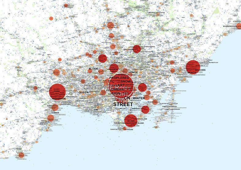
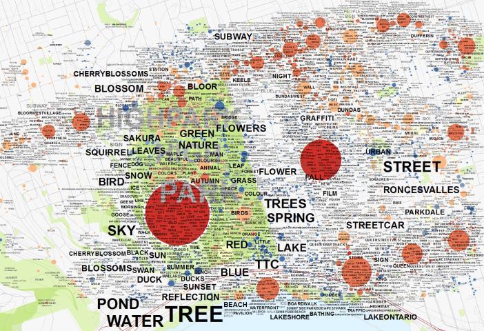
14 Internal derivation of Multiple Representation Tag Maps based on georeferenced word clouds Input: point locations of georeferenced photos from sharing application (e.g. Flickr, Panoramio) with various attributes/tags aim on derivation of tag maps for landscape and urban planning (PhD thesis Dunkel, 2016) Aggregation of photo locations based on hierarchical clustering for Visualisation of the most common tags PhD thesis: A. Dunkel (2016) Assessing the perceived environment through crowdsourced spatial photo content for application to the fields of landscape and urban planning. 16

15 Tag maps Source: Dr.-Ing. Alexander Dunkel, Institute of Cartography, TU Dresden 17

16 Internal derivation of Multiple Representation Various patterns generated by hierarchical clustering Source: Dr.-Ing. Alexander Dunkel, Institute of Cartography, TU Dresden 18

17 Internal derivation of Multiple Representation Hierarchical clustering Variation of cluster distance Derivation of multiple representation for various scales Source: Dr.-Ing. Alexander Dunkel, Institute of Cartography, TU Dresden 19


18 Internal derivation of Multiple Representation Multiple representation (multi-scale view) 20
 Spatial Dimensionen Wo? Prof.")
19 Internal derivation of Multiple Representation Multiple representation (multi-scale view) Spatial Dimensionen Wo? Prof. Burghardt, Institut für Kartographie, TU Dresden 21
20 Derivation of Multiple Representations Internal derivation (generation out of geodata) External assignment (hierarchical structured reference units) Hierarchal clustering (Dendrogram) Tag Cloud Maps Hierarchical tessellation with Grids, Quadtree, Hexagons, Geohash Micro-Diagramme 22
. Micro Diagrams: A Multi-Scale Approach for Mapping Large Categorised Point Datasets.")
21 Multiple Representation through external assignment Micro Diagrams multivariate visualisation of language distributions from Tweet Gröbe, M. and Burghardt, D. (2017). Micro Diagrams: A Multi-Scale Approach for Mapping Large Categorised Point Datasets. Agile Conference, Wageningen, The Netherlands. 23

22 Multiple Representation through external assignment Derivation of multiple representation Source: M.Sc. Mathias Gröbe, Institute of Cartography, TU Dresden 24


23 A Short Discussion of the Micro Diagrams Advantages No overlapping/mixing of colours Abstract presentation of quantities Multiresolution Efficient data storage Disadvantages Complex visualisation Understanding takes time Limited numbers of categories Aggregation can disturb data

24 Broader perspective on Multiple Representation Multiple representation with reproduction of different human perspectives a broader definition of multiple representation could be used to reflect on the varying viewpoints of people (subjective perception) requires specification of different user groups, e.g. regarding age or home town (taken from user profile) example: routes of Camino de Santiago perceived by German photographers Flickr photo locations in Europe (a) for all photographers (left map) and (b) photographers with origin set to Germany (right map) 26
25 Conclusion consideration of scale is essential for the analysis and visualisation of location-based social media the derivation of smaller scale representations of LBSM data can be achieved through automated generalisation (most relevant operations are classification, filtering, selection as well as aggregation, typification) interactive multiple representations provide overview and detail from spatial and semantic point of view patterns and relationships change at different scales 2 derivation strategies for the generation of multiple representations: I) the internal derivation through hierarchical clustering Tag Maps II) the external assignment of hierarchical structured reference units Micro Diagrams LBSM data provide new challenges related to abstraction and derivation of multiscale views 27


26 Prof. Dr.-Ing.habil Dirk Burghardt Institut für Kartographie TU Dresden
 characteristic of the data large amount with strong heterogeneity")
27 Potentials and challenges of LBSM Location-based Social Media (LBSM) data social networks provide platforms for exchange of opinions, experiences and information events take place at specific locations sport events, floods, traffic jam, demo s, comments on restaurants, creation of spatial data as side effect (passive) characteristic of the data large amount with strong heterogeneity actuality of the data, real-time, streaming semantical interpreted user specific location data privacy

28 VGIscience - Volunteered Geographic Information Interpretation, Visualisation and Social Computing (SPP 1894) Klima und Umwelt Annotation, Interpretation, Strukturierung Katastrophenschutz Gesundheit Geographische Informationsgewinnung Geovisuelle Analyse gefilterte Daten Visuelle kartographische Kommunikation Epidemiologie Verkehr Semantische Analyse VGIscience Human- Computer- Interaction Demokratisierung & Partizipation Social Computing Sozialwissenschaften 30
29 10 Generalisierungsoperatoren 31
30 10 Generalisierungsoperatoren 32
VGIscience Summer School Interpretation, Visualisation and Social Computing of Volunteered Geographic Information (VGI)
") VGIscience Summer School Interpretation, Visualisation and Social Computing of Volunteered Geographic Information (VGI) TU Dresden, 11.-15. September 2017 Welcome PhD students working on research topics
VGIscience Summer School Interpretation, Visualisation and Social Computing of Volunteered Geographic Information (VGI) TU Dresden, 11.-15. September 2017 Welcome PhD students working on research topics
Micro Diagrams: A Multi-Scale Approach for Mapping Large Categorised Point Datasets
 Micro Diagrams: A Multi-Scale Approach for Mapping Large Categorised Point Datasets Mathias Gröbe TU Dresden Institute of Cartography 01062 Dresden, Germany mathias.groebe@tu-dresden.de Dirk Burghardt
Deutsche Gesellschaft für Kartographie e.v.
 Deutsche Gesellschaft für Kartographie e.v. Der Vizepräsident Prof. Dr. Manfred Buchroithner, TU Dresden, 01062 Dresden International Cartographic Association Executive Committee Prof. Dr. Manfred Buchroithner
Exploring Urban Areas of Interest. Yingjie Hu and Sathya Prasad
 Exploring Urban Areas of Interest Yingjie Hu and Sathya Prasad What is Urban Areas of Interest (AOIs)? What is Urban Areas of Interest (AOIs)? Urban AOIs exist in people s minds and defined by people s
Assessing pervasive user-generated content to describe tourist dynamics
 Assessing pervasive user-generated content to describe tourist dynamics Fabien Girardin, Josep Blat Universitat Pompeu Fabra, Barcelona, Spain {Fabien.Girardin, Josep.Blat}@upf.edu Abstract. In recent
DM-Group Meeting. Subhodip Biswas 10/16/2014
 DM-Group Meeting Subhodip Biswas 10/16/2014 Papers to be discussed 1. Crowdsourcing Land Use Maps via Twitter Vanessa Frias-Martinez and Enrique Frias-Martinez in KDD 2014 2. Tracking Climate Change Opinions
University of Zurich. On-the-Fly generalization. Zurich Open Repository and Archive. Weibel, R; Burgardt, D. Year: 2008
 University of Zurich Zurich Open Repository and Archive Winterthurerstr. 190 CH-8057 Zurich http://www.zora.uzh.ch Year: 2008 On-the-Fly generalization Weibel, R; Burgardt, D Weibel, R; Burgardt, D (2008).
Reproducible AGILE
 Reproducible Research @ AGILE The term Reproducible Research refers to the idea that the ultimate product of academic research is a scientific paper published along with the data, methods and full computational
Latent Geographic Feature Extraction from Social Media
 Latent Geographic Feature Extraction from Social Media Christian Sengstock* Michael Gertz Database Systems Research Group Heidelberg University, Germany November 8, 2012 Social Media is a huge and increasing
Applying DLM and DCM concepts in a multi-scale data environment
 Applying DLM and DCM concepts in a multi-scale data environment Jantien Stoter 1,2,, Martijn Meijers 1, Peter van Oosterom 1, Dietmar Grunreich 3, Menno-Jan Kraak 4 1 OTB, GISt, Techncial University of
Version 1.1 GIS Syllabus
 GEOGRAPHIC INFORMATION SYSTEMS CERTIFICATION Version 1.1 GIS Syllabus Endorsed 1 Version 1 January 2007 GIS Certification Programme 1. Target The GIS certification is aimed at: Those who wish to demonstrate
Research Group Cartography
 Research Group Cartography Research Group Cartography Towards supporting wayfinding LBS components 1. Mobile devices 2. Communication Network 3. Positioning Component 4. Service and Application Provider
A Framework for Implementing Volunteered Geographic Information Systems
 A Framework for Implementing Volunteered Geographic Information Systems Claus Rinner, Victoria Fast Department of Geography, Ryerson University, Toronto, ON; crinner@ryerson.ca Abstract In an effort to
December 3, Dipartimento di Informatica, Università di Torino. Felicittà. Visualizing and Estimating Happiness in
 : : Dipartimento di Informatica, Università di Torino December 3, 2013 : Outline : from social media Social media users generated contents represent the human behavior in everyday life, but... how to analyze
INTRODUCTION. 13 th AGILE International Conference on Geographic Information Science 2010 Page 1 of 15 Guimarães, Portugal
 13 th AGILE International Conference on Geographic Information Science 2010 Page 1 of 15 A Comparative Study of Proprietary Geodata and Volunteered Geographic Information for Germany Dennis Zielstra 1,
Comparing Flickr tags to a geomorphometric classification. Christian Gschwend and Ross S. Purves
 Comparing Flickr tags to a geomorphometric classification Christian Gschwend and Ross S. Purves 1 Department of Geography, University of Zurich, Winterthurerstrasse 190, CH 8057 Zurich christian.gschwend@geo.uzh.ch,
POLIMI Progress Report
 Project Meeting, 18 July 2018, Turin POLIMI Progress Report Maria Antonia Brovelli, Candan Eylül Kilsedar, Monia Elisa Molinari, Daniele Oxoli PRIN PROJECT: URBAN GEOmatics for Bulk Information Generation,
Harmonizing Level of Detail in OpenStreetMap Based Maps
 Harmonizing Level of Detail in OpenStreetMap Based Maps G. Touya 1, M. Baley 1 1 COGIT IGN France, 73 avenue de Paris 94165 Saint-Mandé France Email: guillaume.touya{at}ign.fr 1. Introduction As OpenStreetMap
Automated Assessment and Improvement of OpenStreetMap Data
 Automated Assessment and Improvement of OpenStreetMap Data Musfira Jilani 1, Padraig Corcoran 1, Michela Bertolotto 1 1 School of Computer Science and Informatics, University College Dublin, Ireland Tel.
Improving Map Generalisation of Buildings by Introduction of Urban Context Rules
 Improving Map Generalisation of Buildings by Introduction of Urban Context Rules S. Steiniger 1, P. Taillandier 2 1 University of Zurich, Department of Geography, Winterthurerstrasse 190, CH 8057 Zürich,
12 Review and Outlook
 12 Review and Outlook 12.1 Review 12.2 Outlook http://www-kdd.isti.cnr.it/nwa Spatial Databases and GIS Karl Neumann, Sarah Tauscher Ifis TU Braunschweig 926 What are the basic functions of a geographic
AdV Project: Map Production of the DTK50
 Geoinformation und Landentwicklung AdV Project: Map Production of the DTK50 Sabine Urbanke, LGL Baden-Württemberg Landesamt für Geoinformation und Landentwicklung Baden-Württemberg (LGL) (State Authority
City, University of London Institutional Repository
 City Research Online City, University of London Institutional Repository Citation: Khalili, N., Wood, J. & Dykes, J. (2009). Mapping the geography of social networks. Paper presented at the GIS Research
UNCERTAINTY AND ERRORS IN GIS
 Christos G. Karydas,, Dr. xkarydas@agro.auth.gr http://users.auth.gr/xkarydas Lab of Remote Sensing and GIS Director: Prof. N. Silleos School of Agriculture Aristotle University of Thessaloniki, GR 1 UNCERTAINTY
Mobile re-use of geo-referenced media content of Sächsische Zeitung
 Faculty of Environmental Sciences Institute for Cartography Master Thesis Mobile re-use of geo-referenced media content of Sächsische Zeitung Abdelrahman Hussein Born on: 5th December 1985 in Cairo, Egypt
Multi agent Evacuation Simulation Data Model for Disaster Management Context
 Multi agent Evacuation Simulation Data Model for Disaster Management Context Mohamed Bakillah, Alexander Zipf, J. Andrés Domínguez, Steve H. L. Liang GI4DM 2012 1 Content Context Requirements for Enhanced
Compact guides GISCO. Geographic information system of the Commission
 Compact guides GISCO Geographic information system of the Commission What is GISCO? GISCO, the Geographic Information System of the COmmission, is a permanent service of Eurostat that fulfils the requirements
Course Introduction II
 CULTURE GEOG 247 Cultural Geography Course Introduction II Prof. Anthony Grande Hunter College-CUNY AFG 2015 Culture is the essence of human geography because it influences all aspects of life on earth.
Geographic Knowledge Discovery Using Ground-Level Images and Videos
 This work was funded in part by a DOE Early Career award, an NSF CAREER award (#IIS- 1150115), and a PECASE award. We gratefully acknowledge NVIDIA for their donated hardware. Geographic Knowledge Discovery
GEOGRAPHY 350/550 Final Exam Fall 2005 NAME:
 1) A GIS data model using an array of cells to store spatial data is termed: a) Topology b) Vector c) Object d) Raster 2) Metadata a) Usually includes map projection, scale, data types and origin, resolution
CONCEPTUAL DEVELOPMENT OF AN ASSISTANT FOR CHANGE DETECTION AND ANALYSIS BASED ON REMOTELY SENSED SCENES
 CONCEPTUAL DEVELOPMENT OF AN ASSISTANT FOR CHANGE DETECTION AND ANALYSIS BASED ON REMOTELY SENSED SCENES J. Schiewe University of Osnabrück, Institute for Geoinformatics and Remote Sensing, Seminarstr.
What should you consider concerning colors in maps in order to illustrate qualitative data, and quantitative data, respectively? Exemplify.
 1, Cartography, 10 p (HA) _ When doing a map based on quantitative data you have for example to decide upon the classification. Three common classifications are Equal interval, Quantiles (percentiles)
Visual Analytics ofmovement
 Gennady Andrienko. Natalia Andrienko Peter Bak Daniel Keim Stefan Wrobel Visual Analytics ofmovement ~ Springer Contents 1 Introduction... 1 1.1 A Single Trajectory.....................................
Exploring representational issues in the visualisation of geographical phenomenon over large changes in scale.
 Institute of Geography Online Paper Series: GEO-017 Exploring representational issues in the visualisation of geographical phenomenon over large changes in scale. William Mackaness & Omair Chaudhry Institute
Understanding Community Mapping as a Socio-Technical Work Domain
 Understanding Community Mapping as a Socio-Technical Work Domain Mark Iliffe 1, Robert J. Houghton 2 and Jeremy Morley 3 1 Horizon Doctoral Training Centre, The University of Nottingham Tel. (0115) 8232316
Towards Fully-automated Driving
 Towards Fully-automated Driving Challenges and Potential Solutions Dr. Gijs Dubbelman Mobile Perception Systems EE-SPS/VCA Mobile Perception Systems 6 PhDs, postdoc, project manager, software engineer,
Visualisation of Spatial Data
 Visualisation of Spatial Data VU Visual Data Science Johanna Schmidt WS 2018/19 2 Visual Data Science Introduction to Visualisation Basics of Information Visualisation Charts and Techniques Introduction
Spatial Data Science. Soumya K Ghosh
 Workshop on Data Science and Machine Learning (DSML 17) ISI Kolkata, March 28-31, 2017 Spatial Data Science Soumya K Ghosh Professor Department of Computer Science and Engineering Indian Institute of Technology,
Maps as Tools for Visual Analysis of Geospatial Data. Dr. Claus Rinner Department of Geography and Environmental Studies Ryerson University
 Maps as Tools for Visual Analysis of Geospatial Data Dr. Claus Rinner Department of Geography and Environmental Studies Ryerson University 1 Geography and data analytics 80% of all datasets are said to
Crowdsourcing Semantics for Big Data in Geoscience Applications
 Wright State University CORE Scholar Computer Science and Engineering Faculty Publications Computer Science and Engineering 2013 Crowdsourcing Semantics for Big Data in Geoscience Applications Thomas Narock
VGI and formal data. EEO / AGI (Scotland) seminar. David Fairbairn Newcastle University School of Civil Engineering & Geosciences
 seminar. David Fairbairn Newcastle University School of Civil Engineering & Geosciences") VGI and formal data EEO / AGI (Scotland) seminar David Fairbairn Newcastle University School of Civil Engineering & Geosciences VGI and formal data Investigating the possible interaction between informal
VGI and formal data EEO / AGI (Scotland) seminar David Fairbairn Newcastle University School of Civil Engineering & Geosciences VGI and formal data Investigating the possible interaction between informal
Relations and Structures in Categorical Maps
 8th ICA WORKSHOP on Generalisation and Multiple Representation, A Coruña (Spain), July 7-8th, 2005 1 Relations and Structures in Categorical Maps Stefan Steiniger and Robert Weibel, University of Zurich
The Concept of Geographic Relevance
 The Concept of Geographic Relevance Tumasch Reichenbacher, Stefano De Sabbata, Paul Crease University of Zurich Winterthurerstr. 190 8057 Zurich, Switzerland Keywords Geographic relevance, context INTRODUCTION
Automatic Generalization of Cartographic Data for Multi-scale Maps Representations
 Environmental Engineering 10th International Conference eissn 2029-7092 / eisbn 978-609-476-044-0 Vilnius Gediminas Technical University Lithuania, 27 28 April 2017 Article ID: enviro.2017.169 http://enviro.vgtu.lt
Converting OpenStreetMap geo data into railml for a Railway Simulation Environment
 Converting OpenStreetMap geo data into railml for a Railway Simulation Environment Christian Rahmig, Andreas Richter DLR Institute of Transportation Systems Braunschweig, Germany > Slide 1 Institute of
Cell-based Model For GIS Generalization
 Cell-based Model For GIS Generalization Bo Li, Graeme G. Wilkinson & Souheil Khaddaj School of Computing & Information Systems Kingston University Penrhyn Road, Kingston upon Thames Surrey, KT1 2EE UK
Geography for Life. Course Overview
 Geography for Life Description In Geography for Life students will explore the world around them. Using the six essential elements established by the National Geographic Society students will be able to
Identification of disaster-affected areas using exploratory visual analysis of georeferenced Tweets: application to a flood event
 Identification of disaster-affected areas using exploratory visual analysis of georeferenced Tweets: application to a flood event Valentina Cerutti ITC Faculty of Geo-Information Science and Earth Observation
Multi-scale Representation: Modelling and Updating
 Multi-scale Representation: Modelling and Updating Osman Nuri ÇOBANKAYA 1, Necla ULUĞTEKİN 2 1 General Command of Mapping, Ankara osmannuri.cobankaya@hgk.msb.gov.tr 2 İstanbul Technical University, İstanbul
Quality Evaluations on Canadian OpenStreetMap Data
 Quality Evaluations on Canadian OpenStreetMap Data Matthew Tenney 1 1 McGill University, Montreal, QC, Matthew.Tenney@mail.mcgill.ca Abstract The OpenStreetMap (OSM) project represents one of the more
APC Part I Workshop. Mapping and Cartography. 14 November 2014
 APC Part I Workshop Mapping and Cartography 14 November 2014 Cartography Cartography is the discipline dealing with the conception, production, dissemination and study of maps in all forms (ICA) A holistic
STATE-OF-THE-ART. Final report available from EuroSDR website OF AUTOMATED GENERALISATION IN COMMERCIAL SOFTWARE
 STATE-OF-THE-ART OF AUTOMATED GENERALISATION IN COMMERCIAL SOFTWARE Jantien Stoter, TU Delft & Kadaster, NL Blanca Baella, ICC, Catalonia Connie Blok, ITC, Enschede, NL Dirk Burghardt, TU Dresden, Germany
Analysis of European Topographic Maps for Monitoring Settlement Development
 Analysis of European Topographic Maps for Monitoring Settlement Development Ulrike Schinke*, Hendrik Herold*, Gotthard Meinel*, Nikolas Prechtel** * Leibniz Institute of Ecological Urban and Regional Development,
Statistical Perspectives on Geographic Information Science. Michael F. Goodchild University of California Santa Barbara
 Statistical Perspectives on Geographic Information Science Michael F. Goodchild University of California Santa Barbara Statistical geometry Geometric phenomena subject to chance spatial phenomena emphasis
A Framework of Detecting Burst Events from Micro-blogging Streams
 , pp.379-384 http://dx.doi.org/10.14257/astl.2013.29.78 A Framework of Detecting Burst Events from Micro-blogging Streams Kaifang Yang, Yongbo Yu, Lizhou Zheng, Peiquan Jin School of Computer Science and
Place this Photo on a Map: A Study of Explicit Disclosure of Location Information
 Place this Photo on a Map: A Study of Explicit Disclosure of Location Information Fabien Girardin 1, Josep Blat 1 1 Department of ICT, Pompeu Fabra University, 08003 Barcelona, Spain {Fabien.Girardin,
Conceptual Aspects of 3D Map Integration in Interactive School Atlases
 Conceptual Aspects of 3D Map Integration in Interactive School Atlases Christian Haeberling Hans Rudolf Baer Institute of Cartography ETH Zurich 8093 Zurich, Switzerland E-Mail: haeberling@karto.baug.ethz.ch
A conceptual model for quality assessment of VGI for the purpose of flood management
 A conceptual model for quality assessment of VGI for the purpose of flood management Lívia Castro Degrossi University of São Paulo São Carlos, Brazil Heidelberg University degrossi@icmc.usp.br João Porto
GISc Technician model. Diploma in GISc / Geoinformatics NQF level 6. Minimum 240 credits
 GISc Technician model. Diploma in GISc / Geoinformatics NQF level. Minimum 20 credits The workforce and competency requirements of a GISc technicians is defined in terms of the Geomatics Act 19 of 2013,
ADDING METADATA TO MAPS AND STYLED LAYERS TO IMPROVE MAP EFFICIENCY
 ADDING METADATA TO MAPS AND STYLED LAYERS TO IMPROVE MAP EFFICIENCY B. Bucher, S. Mustière, L. Jolivet, J. Renard IGN-COGIT, Saint Mandé, France Introduction Standard APIs to visualise geodata on information
Mobility Analytics through Social and Personal Data. Pierre Senellart
 Mobility Analytics through Social and Personal Data Pierre Senellart Session: Big Data & Transport Business Convention on Big Data Université Paris-Saclay, 25 novembre 2015 Analyzing Transportation and
An Information Model for Maps: Towards Cartographic Production from GIS Databases
 An Information Model for s: Towards Cartographic Production from GIS Databases Aileen Buckley, Ph.D. and Charlie Frye Senior Cartographic Researchers, ESRI Barbara Buttenfield, Ph.D. Professor, University
On-demand mapping and integration of thematic data
 On-demand mapping and integration of thematic data Weiming Huang, Ali Mansourian and Lars Harrie Department of Physical Geography and Ecosystem Science, Lund University Sölvegatan 12, SE-223 62 Lund, Sweden
Using Social Media for Geodemographic Applications
 Using Social Media for Geodemographic Applications Muhammad Adnan and Guy Lansley Department of Geography, University College London @gisandtech @GuyLansley Web: http://www.uncertaintyofidentity.com Outline
How a Media Organization Tackles the. Challenge Opportunity. Digital Gazetteer Workshop December 8, 2006
 A Case-Study-In-Process: How a Media Organization Tackles the Georeferencing Challenge Opportunity Digital Gazetteer Workshop December 8, 2006 to increase and diffuse geographic knowledge 1888 to 2006:
What is GIS? Introduction to data. Introduction to data modeling
 What is GIS? Introduction to data Introduction to data modeling 2 A GIS is similar, layering mapped information in a computer to help us view our world as a system A Geographic Information System is a
INSTITUTE OF AERONAUTICAL ENGINEERING (Autonomous) Dundigal, Hyderabad
 Dundigal, Hyderabad") INSTITUTE OF AERONAUTICAL ENGINEERING (Autonomous) Dundigal, Hyderabad -00 0 CIVIL ENGINEERING TUTORIAL QUESTION BANK Course Name : Remote Sensing and GIS Course Code : A00 Class : IV B. Tech I Semester
INSTITUTE OF AERONAUTICAL ENGINEERING (Autonomous) Dundigal, Hyderabad -00 0 CIVIL ENGINEERING TUTORIAL QUESTION BANK Course Name : Remote Sensing and GIS Course Code : A00 Class : IV B. Tech I Semester
Areal Delineation of Home Regions from Contribution and Editing Patterns in OpenStreetMap
 ISPRS Int. J. Geo-Inf. 2014, 3, 1211-1233; doi:10.3390/ijgi3041211 Article ISPRS International Journal of Geo-Information ISSN 2220-9964 www.mdpi.com/journal/ijgi/ Areal Delineation of Home Regions from
An Introduction to Geographic Information System
 An Introduction to Geographic Information System PROF. Dr. Yuji MURAYAMA Khun Kyaw Aung Hein 1 July 21,2010 GIS: A Formal Definition A system for capturing, storing, checking, Integrating, manipulating,
Cross-Linkage Between Mapillary Street Level Photos and OSM Edits
 Cross-Linkage Between Mapillary Street Level Photos and OSM Edits Levente Juhász and Hartwig H. Hochmair Abstract Mapillary is a VGI platform which allows users to contribute crowdsourced street level
Interactions between Levels in an Agent Oriented Model for Generalisation
 Interactions between Levels in an Agent Oriented Model for Generalisation Adrien Maudet Université Paris-Est, IGN, COGIT, Saint-Mandé, France adrien.maudet@ign.fr Abstract. Generalisation is a complex
Planning in a Geospatially Enabled Society. Michael F. Goodchild University of California Santa Barbara
 Planning in a Geospatially Enabled Society Michael F. Goodchild University of California Santa Barbara What is a geospatially enabled society? Knowing the locations of all points of interest and their
SCORE. INSPIRE-ing VOLUNTEERED GEOGRAPHIC INFORMATION: CASES FROM SOUTH EAST EUROPE. mashing up community and spatial technology
 mashing up community and spatial technology INSPIRE-ing VOLUNTEERED GEOGRAPHIC INFORMATION: CASES FROM SOUTH EAST EUROPE Spatial Consulting and Research Group integrating geospatial and organizational
St. Kitts and Nevis Heritage and Culture
 St. Kitts and Nevis Heritage and Culture Eloise Stancioff, Habiba, Departmet of Culture St. Kitts HERA workshop: March 17-20, 2015 Goals Using freely available open source platforms, we implement two different
Smart Citizens. Maria Antonia Brovelli Politecnico di Milano, Italy
 Smart Citizens Maria Antonia Brovelli Politecnico di Milano, Italy UN-GGIM Academic Network Forum Secure Land Rights and Smart Cities: Making It Work for Sustainable Development New York, 31 July 2017
Keywords: ratio-based simplification, data reduction, mobile applications, generalization
 Page 1 of 9 A Generic Approach to Simplification of Geodata for Mobile Applications Theodor Foerster¹, Jantien Stoter¹, Barend Köbben¹ and Peter van Oosterom² ¹ International Institute for Geo-Information
A framework for spatio-temporal clustering from mobile phone data
 A framework for spatio-temporal clustering from mobile phone data Yihong Yuan a,b a Department of Geography, University of California, Santa Barbara, CA, 93106, USA yuan@geog.ucsb.edu Martin Raubal b b
A Simple Tags Categorization Framework Using Spatial Coverage to Discover Geospatial Semantics. TARDY, Camille, MOCCOZET, Laurent, FALQUET, Gilles
 Proceedings Chapter A Simple Tags Categorization Framework Using Spatial Coverage to Discover Geospatial Semantics TARDY, Camille, MOCCOZET, Laurent, FALQUET, Gilles Abstract There exist many popular crowdsourcing
Implementing Visual Analytics Methods for Massive Collections of Movement Data
 Implementing Visual Analytics Methods for Massive Collections of Movement Data G. Andrienko, N. Andrienko Fraunhofer Institute Intelligent Analysis and Information Systems Schloss Birlinghoven, D-53754
An Ontology-based Framework for Modeling Movement on a Smart Campus
 An Ontology-based Framework for Modeling Movement on a Smart Campus Junchuan Fan 1, Kathleen Stewart 1 1 Department of Geographical and Sustainability Sciences, University of Iowa, Iowa City, IA, 52242,
Fundamentals of ArcGIS Desktop Pathway
 Fundamentals of ArcGIS Desktop Pathway Table of Contents ArcGIS Desktop I: Getting Started with GIS 3 ArcGIS Desktop II: Tools and Functionality 5 Understanding Geographic Data 8 Understanding Map Projections
GIS FOR MAZOWSZE REGION - GENERAL OUTLINE
 GIS FOR MAZOWSZE REGION - GENERAL OUTLINE S. Bialousz 1), K Mączewski 2), E. Janczar 2), K. Osinska-Skotak 1) 1) Warsaw University of Technology, Warsaw, Poland 2) Office of the Surveyor of the Mazowieckie
From the Venice Lagoon Atlas towards a collaborative federated system
 From the Venice Lagoon Atlas towards a collaborative federated system City of Venice Alessandro Mulazzani CORILA Consortium for Coordination of Research Activities Concerning the Venice Lagoon System ISMAR-CNR
Geographic Analysis of Linguistically Encoded Movement Patterns A Contextualized Perspective
 Geographic Analysis of Linguistically Encoded Movement Patterns A Contextualized Perspective Alexander Klippel 1, Alan MacEachren 1, Prasenjit Mitra 2, Ian Turton 1, Xiao Zhang 2, Anuj Jaiswal 2, Kean
Software. People. Data. Network. What is GIS? Procedures. Hardware. Chapter 1
 People Software Data Network Procedures Hardware What is GIS? Chapter 1 Why use GIS? Mapping Measuring Monitoring Modeling Managing Five Ms of Applied GIS Chapter 2 Geography matters Quantitative analyses
A 3D GEOVISUALIZATION APPROACH TO CRIME MAPPING
 A 3D GEOVISUALIZATION APPROACH TO CRIME MAPPING Markus Wolff, Hartmut Asche 3D-Geoinformation Research Group Department of geography University of Potsdam Markus.Wolff@uni-potsdam.de, gislab@uni-potsdam.de
High Resolution Land Use Information by combined Analysis of Digital Landscape Models and Statistical Data Sets. Tobias Krüger Gotthard Meinel
 High Resolution Land Use Information by combined Analysis of Digital Landscape Models and Statistical Data Sets Tobias Krüger Gotthard Meinel Agenda Monitoring approach Input Data Data Processing Output
DANIEL WILSON AND BEN CONKLIN. Integrating AI with Foundation Intelligence for Actionable Intelligence
 DANIEL WILSON AND BEN CONKLIN Integrating AI with Foundation Intelligence for Actionable Intelligence INTEGRATING AI WITH FOUNDATION INTELLIGENCE FOR ACTIONABLE INTELLIGENCE in an arms race for artificial
A General Framework for Conflation
 A General Framework for Conflation Benjamin Adams, Linna Li, Martin Raubal, Michael F. Goodchild University of California, Santa Barbara, CA, USA Email: badams@cs.ucsb.edu, linna@geog.ucsb.edu, raubal@geog.ucsb.edu,
GENERALIZATION APPROACHES FOR CAR NAVIGATION SYSTEMS A.O. Dogru 1, C., Duchêne 2, N. Van de Weghe 3, S. Mustière 2, N. Ulugtekin 1
 GENERALIZATION APPROACHES FOR CAR NAVIGATION SYSTEMS A.O. Dogru 1, C., Duchêne 2, N. Van de Weghe 3, S. Mustière 2, N. Ulugtekin 1 1 Istanbul Technical University, Cartography Division, Istanbul, Turkey
UC Berkeley International Conference on GIScience Short Paper Proceedings
 UC Berkeley International Conference on GIScience Short Paper Proceedings Title Crowd-sorting: reducing bias in decision making through consensus generated crowdsourced spatial information Permalink https://escholarship.org/uc/item/5wt35578
Research topic: Generalisation and Multiple Representation of Location-Based Social Media Data
 Research topic: Generalisation and Multiple Representation of Location-Based Social Media Data Prof. Dr.-Ing. habil. Dirk Burghardt, Institute of Cartography, TU Dresden Multi-scale approach applied to
Crowdsourcing, Citizen Science & INSPIRE
 Crowdsourcing, Citizen Science & INSPIRE Muki Haklay & Claire Ellul Extreme Citizen Science (ExCiteS) research group, UCL @mhaklay / @UCL_ExCiteS Outline Three eras of environmental information: By experts,
Quality analysis of the Parisian OSM toponyms evolution
 CHAPTER 8 Quality analysis of the Parisian OSM toponyms evolution Vyron Antoniou*, Guillaume Touya and Ana-Maria Raimond *Hellenic Military Academy, Greece, v.antoniou@ucl.ac.uk Laboratoire COGIT, Institut
Census Geography, Geographic Standards, and Geographic Information
 Census Geography, Geographic Standards, and Geographic Information Michael Ratcliffe Geography Division US Census Bureau New Mexico State Data Center Data Users Conference November 19, 2015 Today s Presentation
Application Domain Extensions definition for crowd source and Volunteer Geographic Information for smart-cities services deployment.
 Application Domain Extensions definition for crowd source and Volunteer Geographic Information for smart-cities services deployment. F. Prandi, R. de Amicis, P. Parslow, M. Ford, E. D Hondt Outlook Introduction
The Emotion-Aware City: Using Ambient Geographic Information (AGI) in order to understand emotion & stress within smart cities
 in order to understand emotion & stress within smart cities") The Emotion-Aware City: Using Ambient Geographic Information (AGI) in order to understand emotion & stress within smart cities Tiago H. Moreira de Oliveira NOVA IMS, Universidade NOVA de Lisboa, Portugal
The Emotion-Aware City: Using Ambient Geographic Information (AGI) in order to understand emotion & stress within smart cities Tiago H. Moreira de Oliveira NOVA IMS, Universidade NOVA de Lisboa, Portugal
City of Jerez Urban Core Densification proposal; An Agent Based Spatio-temporal model
 Modelling urban population allocation City of Jerez Urban Core Densification proposal; An Agent Based Spatio-temporal model Elke Sauter Julia Úbeda Who we are & why we are here Masters programme: Geographical
ArcGIS is Advancing. Both Contributing and Integrating many new Innovations. IoT. Smart Mapping. Smart Devices Advanced Analytics
 ArcGIS is Advancing IoT Smart Devices Advanced Analytics Smart Mapping Real-Time Faster Computing Web Services Crowdsourcing Sensor Networks Both Contributing and Integrating many new Innovations ArcGIS
Discovering Geographical Topics in Twitter
 Discovering Geographical Topics in Twitter Liangjie Hong, Lehigh University Amr Ahmed, Yahoo! Research Alexander J. Smola, Yahoo! Research Siva Gurumurthy, Twitter Kostas Tsioutsiouliklis, Twitter Overview