Reproducible AGILE
|
|
|
- Ernest Gray
- 5 years ago
- Views:
Transcription
1 Reproducible AGILE The term Reproducible Research refers to the idea that the ultimate product of academic research is a scientific paper published along with the data, methods and full computational environment used to produce the results in the paper. Reproducibility is a principle of good scientific practice that allows other researchers to verify work that has been done. We are interested in the current state of reproducibility in GIScience. Our motivation is to develop concrete recommendations for improving reproducibility of research work in the GIScience community. Your views and feedback on the reproducibility of your research would be highly appreciated! 1. address *
2 2. Please select your nominated AGILE Best Paper. Mark only one oval. Zhu et al. (2017) "Beyond pairs: Generalizing the geo dipole for quantifying spatial patterns in geographic fields" Knoth et al. (2017) "3D Building Maps for Everyone Mapping Buildings Using VGI" Konkol et al. (2017) "Follow the Signs Countering Disengagement from the Real World During City Exploration" Haumann et al. (2017) "Energy based Routing and Cruising Range Estimation for Electric Bicycles" Brinkhoff (2017) "Supporting Dynamic Labeling in Web Map Applications" Almer et al. (2016) "Critical Situation Monitoring at Large Scale Events from Airborne Video Based Crowd Dynamics Analysis Alexander" Wiemann (2016) "Spatial Data Relations as a Means to Enrich Species Observations from Crowdsourcing" Juhasz & Hochmair (2016) "Cross Linkage Between Mapillary Street Level Photos and OSM Edits" Josselin et al. (2016) "Sonorous Cartography for Sighted and Blind People" Rosser et al. (2016) "Full Meta Objects for flexible geoprocessing workflows: profiling WPS or BPMN?" Kuhn & Ballatore (2015) "Designing a Language for Spatial Computing" Mazimpaka & Timpf (2015) "Exploring the Potential of Combining Taxi GPS and Flickr Data for Discovering Functional Regions" Steuer et al. (2015) "Voluminator Approximating the Volume of 3D Buildings to Overcome Topological Errors" Fogliaroni & Hobel (2015) "Implementing Naïve Geography via Qualitative Spatial Relation Queries" Heinz & Schlieder (2015) "An Agent Based Simulation Framework for Location Based Games" Scheider et al. (2014) "Encoding and Querying Historic Map Content" Groechenig et al. (2014) "Estimating completeness of VGI datasets by analyzing community activity over time periods" Fan et al. (2014) "Estimation of Building Types on OpenStreetMap Based on Urban Morphology Analysis Hongchao" Soleymani et al. (2014) "Capability of movement features extracted from GPS trajectories for the classification of fine grained behaviors" Wiemann & Bernard (2014) "Linking crowdsourced observations with INSPIRE" Osaragi & Tsuda (2013) "Facility use choice model with travel costs incorporating means of transportation and travel direction" Baglatzi & Kuhn (2013) "On the formulation of conceptual spaces for land cover classification systems" Schwering et al. (2013) "Orientation Information in Different Forms of Route Instructions" Stein & Schlieder (2013) "A Geowiki for Participatory Mobility 2 Volunteered Geographic Information" Osaragi & Hoshino (2012) "Predicting Spatiotemporal Distribution of Transient Occupants in Urban Areas" Magalhaes et al. (2012) "A new method for computing the drainage network based on raising the level of an ocean surrounding the terrain" Foerster et al. (2012) "Live geoinformation with standardized geoprocessing services" Merki & Laube (2012) "Detecting reaction movement patterns in trajectory data"
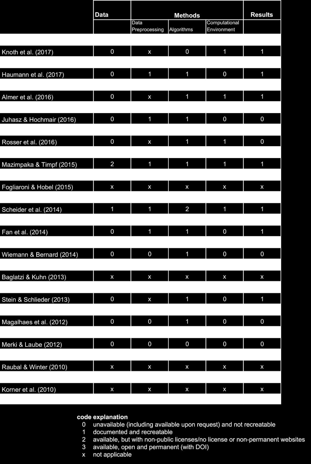
3 Kiefer et al. (2012) "Location Aware Mobile Eye Tracking for the Explanation of Wayfinding behavior" Raubal & Winter (2010) "A spatio temporal model towards ad hoc collaborative decisionmaking" Schaeffer et al. (2010) "Towards Spatial Data Infrastructures in the Clouds" Korner et al. (2010) "Visit Potential: A Common Vocabulary for the Analysis of Entity Location Interactions in Mobility Applications" 3. Are you the first author of this paper? Mark only one oval. Yes No 4. Have you considered the reproducibility of research published in your nominated paper? Mark only one oval. Yes, it is important to me that my research is fully reproducible Yes, I have somewhat considered reproducibility No, I was not concerned with it Other: We have investigated all the papers nominated for the AGILE Best Paper in The following table shows the results of our evaluation. You can find your paper there as well.

4
5 5. Do you agree with our rating? Please comment Not too surprisingly, we have found that none of the papers were fully reproducible*. *a fully reproducible paper would make sure that a reviewer or reader can recreate precisely the setting, including the prerequisite knowledge and the computational environment, of a research paper. In case of the former, the argument must be clear and understandable, the latter requires a detailed description of used software and data, both of which must be openly available. 6. Please rate how strongly the following circumstances have hindered you from providing all data, methods and results used/developed during your research? Mark only one oval per row. Not at all Slightly hindered Moderately hindered Strongly hindered Main reason The need to invest more time into the publication Lack of knowledge how to include data/methods/results into the publication Lack of tools that would help to attach data/methods/results to the publication Lack of motivation or incentive Legal restrictions (e.g. privacy issues or copyright) 7. Please add here if there were any other hindering circumstances 8. What would you suggest to AGILE community to encourage publishing fully reproducible papers?
6 9. We would like to ask for your consent to discuss your answers to this survey in our publication. Check all that apply. Yes, I agree that my answers will be discussed in a publication. Send me a copy of my responses. Powered by
A General Framework for Conflation
 A General Framework for Conflation Benjamin Adams, Linna Li, Martin Raubal, Michael F. Goodchild University of California, Santa Barbara, CA, USA Email: badams@cs.ucsb.edu, linna@geog.ucsb.edu, raubal@geog.ucsb.edu,
Generalisation and Multiple Representation of Location-Based Social Media Data
 Generalisation and Multiple Representation of Location-Based Social Media Data Dirk Burghardt, Alexander Dunkel and Mathias Gröbe, Institute of Cartography Outline 1. Motivation VGI and spatial data from
Quality Evaluations on Canadian OpenStreetMap Data
 Quality Evaluations on Canadian OpenStreetMap Data Matthew Tenney 1 1 McGill University, Montreal, QC, Matthew.Tenney@mail.mcgill.ca Abstract The OpenStreetMap (OSM) project represents one of the more
Your web browser (Safari 7) is out of date. For more security, comfort and. the best experience on this site: Update your browser Ignore
 is out of date. For more security, comfort and. the best experience on this site: Update your browser Ignore") Your web browser (Safari 7) is out of date. For more security, comfort and Activityengage the best experience on this site: Update your browser Ignore Introduction to GIS What is a geographic information
Your web browser (Safari 7) is out of date. For more security, comfort and Activityengage the best experience on this site: Update your browser Ignore Introduction to GIS What is a geographic information
TRAITS to put you on the map
 TRAITS to put you on the map Know what s where See the big picture Connect the dots Get it right Use where to say WOW Look around Spread the word Make it yours Finding your way Location is associated with
Urban Geo-Informatics John W Z Shi
 Urban Geo-Informatics John W Z Shi Urban Geo-Informatics studies the regularity, structure, behavior and interaction of natural and artificial systems in the urban context, aiming at improving the living
A conceptual model for quality assessment of VGI for the purpose of flood management
 A conceptual model for quality assessment of VGI for the purpose of flood management Lívia Castro Degrossi University of São Paulo São Carlos, Brazil Heidelberg University degrossi@icmc.usp.br João Porto
Geo-Enabling Mountain Bike Trail Maintenance:
 Title Slide Geo-Enabling Mountain Bike Trail Maintenance: Enhanced Stewardship of the Fountainhead Mountain Bike Trail through GIS Technology Ruthann Ligon Follow the Trail Fountainhead Mountain Bike
An Ontology-based Framework for Modeling Movement on a Smart Campus
 An Ontology-based Framework for Modeling Movement on a Smart Campus Junchuan Fan 1, Kathleen Stewart 1 1 Department of Geographical and Sustainability Sciences, University of Iowa, Iowa City, IA, 52242,
Smart Citizens. Maria Antonia Brovelli Politecnico di Milano, Italy
 Smart Citizens Maria Antonia Brovelli Politecnico di Milano, Italy UN-GGIM Academic Network Forum Secure Land Rights and Smart Cities: Making It Work for Sustainable Development New York, 31 July 2017
ArcGIS is Advancing. Both Contributing and Integrating many new Innovations. IoT. Smart Mapping. Smart Devices Advanced Analytics
 ArcGIS is Advancing IoT Smart Devices Advanced Analytics Smart Mapping Real-Time Faster Computing Web Services Crowdsourcing Sensor Networks Both Contributing and Integrating many new Innovations ArcGIS
Assessing pervasive user-generated content to describe tourist dynamics
 Assessing pervasive user-generated content to describe tourist dynamics Fabien Girardin, Josep Blat Universitat Pompeu Fabra, Barcelona, Spain {Fabien.Girardin, Josep.Blat}@upf.edu Abstract. In recent
Research Group Cartography
 Research Group Cartography Research Group Cartography Towards supporting wayfinding LBS components 1. Mobile devices 2. Communication Network 3. Positioning Component 4. Service and Application Provider
GIScience & Mobility. Prof. Dr. Martin Raubal. Institute of Cartography and Geoinformation SAGEO 2013 Brest, France
 GIScience & Mobility Prof. Dr. Martin Raubal Institute of Cartography and Geoinformation mraubal@ethz.ch SAGEO 2013 Brest, France 25.09.2013 1 www.woodsbagot.com 25.09.2013 2 GIScience & Mobility Modeling
DP Project Development Pvt. Ltd.
 Dear Sir/Madam, Greetings!!! Thanks for contacting DP Project Development for your training requirement. DP Project Development is leading professional training provider in GIS technologies and GIS application
Introducing the WISERD Geoportal. WISERD DATA TEAM Dr Robert Berry & Dr Richard Fry, University of Glamorgan Dr Scott Orford, Cardiff University
 Introducing the WISERD Geoportal WISERD DATA TEAM Dr Robert Berry & Dr Richard Fry, University of Glamorgan Dr Scott Orford, Cardiff University WISERD What is WISERD? Wales Institute of Social and Economic
A route map to calibrate spatial interaction models from GPS movement data
 A route map to calibrate spatial interaction models from GPS movement data K. Sila-Nowicka 1, A.S. Fotheringham 2 1 Urban Big Data Centre School of Political and Social Sciences University of Glasgow Lilybank
Your web browser (Safari 7) is out of date. For more security, comfort and. the best experience on this site: Update your browser Ignore
 is out of date. For more security, comfort and. the best experience on this site: Update your browser Ignore") Your web browser (Safari 7) is out of date. For more security, comfort and Activityengage the best experience on this site: Update your browser Ignore Comparing Historical Maps How can historical maps
Your web browser (Safari 7) is out of date. For more security, comfort and Activityengage the best experience on this site: Update your browser Ignore Comparing Historical Maps How can historical maps
Application Domain Extensions definition for crowd source and Volunteer Geographic Information for smart-cities services deployment.
 Application Domain Extensions definition for crowd source and Volunteer Geographic Information for smart-cities services deployment. F. Prandi, R. de Amicis, P. Parslow, M. Ford, E. D Hondt Outlook Introduction
Network Analysis Services in ArcGIS Enterprise. Deelesh Mandloi
 Network Analysis Services in ArcGIS Enterprise Deelesh Mandloi Slides from this demo theater http://esriurl.com/uc17nas Agenda Network Analyst concepts ArcGIS Enterprise publishing workflow - Geoprocessing
Cognitive Engineering for Geographic Information Science
 Cognitive Engineering for Geographic Information Science Martin Raubal Department of Geography, UCSB raubal@geog.ucsb.edu 21 Jan 2009 ThinkSpatial, UCSB 1 GIScience Motivation systematic study of all aspects
You are Building Your Organization s Geographic Knowledge
 You are Building Your Organization s Geographic Knowledge And Increasingly Making it Available Sharing Data Publishing Maps and Geo-Apps Developing Collaborative Approaches Citizens Knowledge Workers Analysts
Geographic Information Systems (GIS) in Environmental Studies ENVS Winter 2003 Session III
 in Environmental Studies ENVS Winter 2003 Session III") Geographic Information Systems (GIS) in Environmental Studies ENVS 6189 3.0 Winter 2003 Session III John Sorrell York University sorrell@yorku.ca Session Purpose: To discuss the various concepts of space,
Geographic Information Systems (GIS) in Environmental Studies ENVS 6189 3.0 Winter 2003 Session III John Sorrell York University sorrell@yorku.ca Session Purpose: To discuss the various concepts of space,
Key Points Sharing fosters participation and collaboration Metadata has a big role in sharing Sharing is not always easy
 Sharing Resources Geoff Mortson esri, Inc. SDI Solutions Team Key Points Sharing fosters participation and collaboration Metadata has a big role in sharing Sharing is not always easy Data Sharing is Good
Steve Pietersen Office Telephone No
 Steve Pietersen Steve.Pieterson@durban.gov.za Office Telephone No. 031 311 8655 Overview Why geography matters The power of GIS EWS GIS water stats EWS GIS sanitation stats How to build a GIS system EWS
GIS and Community Health. GIS and Community Health. Institutional Context and Interests in GIS Development. GIS and Community Health
 GIS and Community Health GIS and Community Health Some critiques of GIS emphasize the potentially harmful social consequences of the diffusion of GIS technology, including reinforcing the power of state
Extraction of Spatio-Temporal data about Historical events from text documents
 Faculty of Environmental Sciences, Department of Geosciences, Chair of Geoinformatics Extraction of Spatio-Temporal data about Historical events from text documents Case Study: German-Herero war of resistance
Smart Route Recommendations based on Historical GPS Trajectories and Weather Information
 Smart Route Recommendations based on Historical GPS Trajectories and Weather Information Xingzhe Xie1, Kevin Wong2, Hamid Aghajan2 and Wilfried Philips1 1 TELIN IPI iminds, Ghent University, Belgium 2
VGIscience Summer School Interpretation, Visualisation and Social Computing of Volunteered Geographic Information (VGI)
") VGIscience Summer School Interpretation, Visualisation and Social Computing of Volunteered Geographic Information (VGI) TU Dresden, 11.-15. September 2017 Welcome PhD students working on research topics
VGIscience Summer School Interpretation, Visualisation and Social Computing of Volunteered Geographic Information (VGI) TU Dresden, 11.-15. September 2017 Welcome PhD students working on research topics
Cross-Linkage Between Mapillary Street Level Photos and OSM Edits
 Cross-Linkage Between Mapillary Street Level Photos and OSM Edits Levente Juhász and Hartwig H. Hochmair Abstract Mapillary is a VGI platform which allows users to contribute crowdsourced street level
Spatial Data Science. Soumya K Ghosh
 Workshop on Data Science and Machine Learning (DSML 17) ISI Kolkata, March 28-31, 2017 Spatial Data Science Soumya K Ghosh Professor Department of Computer Science and Engineering Indian Institute of Technology,
Mappings For Cognitive Semantic Interoperability
 Mappings For Cognitive Semantic Interoperability Martin Raubal Institute for Geoinformatics University of Münster, Germany raubal@uni-muenster.de SUMMARY Semantic interoperability for geographic information
Basics of GIS reviewed
 Basics of GIS reviewed Martin Breunig Karlsruhe Institute of Technology martin.breunig@kit.edu GEODETIC INSTITUTE, DEPARTMENT OF CIVIL ENGINEERING, GEO AND ENVIRONMENTAL SCIENCES, CHAIR IN GEOINFORMATICS
Modeling Discrete Processes Over Multiple Levels Of Detail Using Partial Function Application
 Modeling Discrete Processes Over Multiple Levels Of Detail Using Partial Function Application Paul WEISER a and Andrew U. FRANK a a Technical University of Vienna Institute for Geoinformation and Cartography,
The Recognition of Temporal Patterns in Pedestrian Behaviour Using Visual Exploration Tools
 The Recognition of Temporal Patterns in Pedestrian Behaviour Using Visual Exploration Tools I. Kveladze 1, S. C. van der Spek 2, M. J. Kraak 1 1 University of Twente, Faculty of Geo-Information Science
ArcGIS. for Server. Understanding our World
 ArcGIS for Server Understanding our World ArcGIS for Server Create, Distribute, and Manage GIS Services You can use ArcGIS for Server to create services from your mapping and geographic information system
Detecting Origin-Destination Mobility Flows From Geotagged Tweets in Greater Los Angeles Area
 Detecting Origin-Destination Mobility Flows From Geotagged Tweets in Greater Los Angeles Area Song Gao 1, Jiue-An Yang 1,2, Bo Yan 1, Yingjie Hu 1, Krzysztof Janowicz 1, Grant McKenzie 1 1 STKO Lab, Department
Smart Data Collection and Real-time Digital Cartography
 Smart Data Collection and Real-time Digital Cartography Yuji Murayama and Ko Ko Lwin Division of Spatial Information Science Faculty of Life and Environmental Sciences University of Tsukuba IGU 2013 1
ArcGIS Enterprise: Out-of-the-Box Spatial Analysis. Vicki Cove Hilary Curtis
 ArcGIS Enterprise: Out-of-the-Box Spatial Analysis Vicki Cove Hilary Curtis Agenda What is spatial analysis? Spatial analysis with ArcGIS Enterprise Analysis demos: - Sunflower proximity to bees - Tourists
WS/FCS Unit Planning Organizer
 WS/FCS Unit Planning Organizer Subject(s) Social Studies Conceptual Lenses Grade/Course 3rd Place Unit of Study Five Themes of Geography Location Unit Title Pacing Geo Explorers 20-22 days Human environment
94-802Z: Geographic Information Systems Summer 2018
 94-802Z: Geographic Information Systems Summer 2018 Instructor: Professor Kristen Kurland Teaching Assistant(s): (Office hours to be posted on Canvas) TBA Class Web Site: http:/www.cmu.edu/canvas
Multi agent Evacuation Simulation Data Model for Disaster Management Context
 Multi agent Evacuation Simulation Data Model for Disaster Management Context Mohamed Bakillah, Alexander Zipf, J. Andrés Domínguez, Steve H. L. Liang GI4DM 2012 1 Content Context Requirements for Enhanced
The Global Fundamental Geospatial Data Themes Journey. April Clare Hadley WG Chair
 The Global Fundamental Geospatial Data Themes Journey April 2018 Clare Hadley WG Chair The Road to here Why Global? Why Geospatial? Why Fundamental? Why Themes? The route we took Where does the road go
A Conceptual Model for Analyzing Contribution Patterns in the Context of VGI
 A Conceptual Model for Analyzing Contribution Patterns in the Context of VGI Karl Rehrl, Simon Gröechenig, Hartwig Hochmair, Sven Leitinger, Renate Steinmann and Andreas Wagner Abstract The chapter proposes
Generation of landmarks from 3D city models and OSM data
 Editors: Jérôme Gensel, Didier Josselin and Danny Vandenbroucke Generation of landmarks from 3D city models and OSM data Eva Nuhn Eva.nuhn@unibw.de Wolfgang Reinhardt Wolfgang.reinhardt@unibw.de Abstract
Space-adjusting Technologies and the Social Ecologies of Place
 Space-adjusting Technologies and the Social Ecologies of Place Donald G. Janelle University of California, Santa Barbara Reflections on Geographic Information Science Session in Honor of Michael Goodchild
* Abstract. Keywords: Smart Card Data, Public Transportation, Land Use, Non-negative Matrix Factorization.
 Analysis of Activity Trends Based on Smart Card Data of Public Transportation T. N. Maeda* 1, J. Mori 1, F. Toriumi 1, H. Ohashi 1 1 The University of Tokyo, 7-3-1 Hongo Bunkyo-ku, Tokyo, Japan *Email:
Three-Dimensional Visualization of Activity-Travel Patterns
 C. Rinner 231 Three-Dimensional Visualization of Activity-Travel Patterns Claus Rinner Department of Geography University of Toronto, Canada rinner@geog.utoronto.ca ABSTRACT Geographers have long been
Esri Production Mapping: Map Automation & Advanced Cartography MADHURA PHATERPEKAR JOE SHEFFIELD
 Esri Production Mapping: Map Automation & Advanced Cartography MADHURA PHATERPEKAR JOE SHEFFIELD Traditional Cartography What you really want Cartographic Workflow Output Cartographic Data Symbology Layout
Your web browser (Safari 7) is out of date. For more security, comfort and the best experience on this site: Update your browser Ignore
 is out of date. For more security, comfort and the best experience on this site: Update your browser Ignore") Your web browser (Safari 7) is out of date. For more security, comfort and the best experience on this site: Update your browser Ignore Activityengage O CEAN AND SEA BO RDERS Who has the rights to valuable
Your web browser (Safari 7) is out of date. For more security, comfort and the best experience on this site: Update your browser Ignore Activityengage O CEAN AND SEA BO RDERS Who has the rights to valuable
Getting Started with Community Maps
 Esri International User Conference San Diego, California Technical Workshops July 24, 2012 Getting Started with Community Maps Shane Matthews and Tamara Yoder Topics for this Session ArcGIS is a complete
UC Berkeley International Conference on GIScience Short Paper Proceedings
 UC Berkeley International Conference on GIScience Short Paper Proceedings Title Crowd-sorting: reducing bias in decision making through consensus generated crowdsourced spatial information Permalink https://escholarship.org/uc/item/5wt35578
LUIZ FERNANDO F. G. DE ASSIS, TÉSSIO NOVACK, KARINE R. FERREIRA, LUBIA VINHAS AND ALEXANDER ZIPF
 A discussion of crowdsourced geographic information initiatives and big Earth observation data architectures for land-use and land-cover change monitoring LUIZ FERNANDO F. G. DE ASSIS, TÉSSIO NOVACK, KARINE
Why Is Cartographic Generalization So Hard?
 1 Why Is Cartographic Generalization So Hard? Andrew U. Frank Department for Geoinformation and Cartography Gusshausstrasse 27-29/E-127-1 A-1040 Vienna, Austria frank@geoinfo.tuwien.ac.at 1 Introduction
Innovation. The Push and Pull at ESRI. September Kevin Daugherty Cadastral/Land Records Industry Solutions Manager
 Innovation The Push and Pull at ESRI September 2004 Kevin Daugherty Cadastral/Land Records Industry Solutions Manager The Push and The Pull The Push is the information technology that drives research and
Future Proofing the Provision of Geoinformation: Emerging Technologies
 Future Proofing the Provision of Geoinformation: Emerging Technologies An Exchange Forum with the Geospatial Industry William Cartwright Chair JBGIS Second High Level Forum on Global Geospatial Information
Crowdsourcing for individual needs the case of routing and navigation for mobility-impaired persons
 CHAPTER 24 Crowdsourcing for individual needs the case of routing and navigation for mobility-impaired persons Alexander Zipf*, Amin Mobasheri, Adam Rousell and Stefan Hahmann GIScience research group,
The Underutilization of GIS & How to Cure It. Adam Carnow Esri
 The Underutilization of GIS & How to Cure It Adam Carnow Esri What is GIS? A framework to organize, communicate, and understand the science of our world Business Intelligence (BI) is the set of
From Research Objects to Research Networks: Combining Spatial and Semantic Search
 From Research Objects to Research Networks: Combining Spatial and Semantic Search Sara Lafia 1 and Lisa Staehli 2 1 Department of Geography, UCSB, Santa Barbara, CA, USA 2 Institute of Cartography and
Collaborative Mobility: Using Geographic Information Science to Cultivate Cooperative Transportation. Harvey J. Miller
 Collaborative Mobility: Using Geographic Information Science to Cultivate Cooperative Transportation Harvey J. Miller Department of Geography University of Utah, Salt Lake City, Utah USA harvey.miller@geog.utah.edu
Towards Geographic Information Observatories
 Towards Geographic Information Observatories Krzysztof Janowicz 1, Benjamin Adams 2, Grant McKenzie 1, and Tomi Kauppinen 3,4 1 University of California, Santa Barbara, USA 2 The University of Auckland,
GOVERNMENT MAPPING WORKSHOP RECOVER Edmonton s Urban Wellness Plan Mapping Workshop December 4, 2017
 GOVERNMENT MAPPING WORKSHOP 12.4.17 RECOVER Edmonton s Urban Wellness Plan Mapping Workshop December 4, 2017 In July of 2017, City Council directed administration to develop RECOVER, Edmonton s Urban Wellness
Intelligent GIS: Automatic generation of qualitative spatial information
 Intelligent GIS: Automatic generation of qualitative spatial information Jimmy A. Lee 1 and Jane Brennan 1 1 University of Technology, Sydney, FIT, P.O. Box 123, Broadway NSW 2007, Australia janeb@it.uts.edu.au
Enhance Security, Safety and Efficiency With Geospatial Visualization
 Areas within 10 minutes of an exit are emphasized on this map, to give an indication of how accessible neighborhoods are by highway. The colors represent 1, 3, 5 and 10 minute increments from the exits.
Comparing Flickr tags to a geomorphometric classification. Christian Gschwend and Ross S. Purves
 Comparing Flickr tags to a geomorphometric classification Christian Gschwend and Ross S. Purves 1 Department of Geography, University of Zurich, Winterthurerstrasse 190, CH 8057 Zurich christian.gschwend@geo.uzh.ch,
Your web browser (Safari 7) is out of date. For more security, comfort and. the best experience on this site: Update your browser Ignore
 is out of date. For more security, comfort and. the best experience on this site: Update your browser Ignore") Your web browser (Safari 7) is out of date. For more security, comfort and lesson the best experience on this site: Update your browser Ignore Political Borders Why are the borders of countries located
Your web browser (Safari 7) is out of date. For more security, comfort and lesson the best experience on this site: Update your browser Ignore Political Borders Why are the borders of countries located
Assessing people travel behavior using GPS and open data to validate neighbourhoods characteristics
 Assessing people travel behavior using GPS and open data to validate neighbourhoods characteristics Matilde Oliveti Delft University of Technology Julianalaan 134, 2628 BL Delft, the Netherlands matilde.oliveti@libero.it
Trip and Parking Generation Study of Orem Fitness Center-Abstract
 Trip and Parking Generation Study of Orem Fitness Center-Abstract The Brigham Young University Institute of Transportation Engineers student chapter (BYU ITE) completed a trip and parking generation study
An outlook for OpenStreetMap
 An outlook for OpenStreetMap Peter Mooney This volume has presented OpenStreetMap in GIScience: experiences, research and applications with a collection of experiences and research carried out with OpenStreetMap
Esri s Living Atlas of the World Community Maps
 Esri s Living Atlas of the World Community Maps Seth Sarakaitis Wednesday May 7, 2014 ArcGIS Living Atlas Concept Living Atlas Content Tour Contributing to the Living Atlas (Community Maps) Seth Sarakaitis
Web 2.0, map production & publishing and geospatial information dissemenation
 Web 2.0, map production & publishing and geospatial information dissemenation Professor William Cartwright President, International Cartographic Association William Cartwright 18th UNRCC for Asia and the
ArcGIS Enterprise: What s New. Philip Heede Shannon Kalisky Melanie Summers Sam Williamson
 ArcGIS Enterprise: What s New Philip Heede Shannon Kalisky Melanie Summers Sam Williamson ArcGIS Enterprise is the new name for ArcGIS for Server What is ArcGIS Enterprise ArcGIS Enterprise is powerful
ESRI Survey Summit August Clint Brown Director of ESRI Software Products
 ESRI Survey Summit August 2006 Clint Brown Director of ESRI Software Products Cadastral Fabric How does Cadastral fit with Survey? Surveyors process raw field observations Survey measurements define high-order
June 19 Huntsville, Alabama 1
 June 19 Huntsville, Alabama 1 Real-Time Geospatial Data: The Fusion of PI and ArcGIS Enabling Smarter Facilities Management OSIsoft and Esri Mapping and Location Analytics Platform Supporting Your Use
Kentucky Collaborates in GeoMAPP Project: The Advantages and Challenges of Archiving in a State with a Centralized GIS
 Kentucky Collaborates in GeoMAPP Project: The Advantages and Challenges of Archiving in a State with a Centralized GIS Geospatial Multistate Archive and Preservation Partnership By Glen McAninch Best Practices
What is Human Geography? HUMAN GEOGRAPHY. Human Geography. Human Geography 5/18/2015. Example of Differences: Hurricane Katrina
 What is Human Geography? Geography is the science of place and space. Geographers ask: Where are things located? Why things are located where they are? How places differ from one another? How people interact
Will this program be printed in the Bulletin? Yes No
 NEW UNDERGRADUATE MINOR / CHANGE UNDERGRADUATE MINOR FORM Please fill out Section I. SECTION I: GENERAL INFORMATION Program: GEO Minor: Geography College: A&S Department: Geography Bulletin PP: 135 CIP
GIS = Geographic Information Systems;
 What is GIS GIS = Geographic Information Systems; What Information are we talking about? Information about anything that has a place (e.g. locations of features, address of people) on Earth s surface,
Arne SCHILLING, Steffen NEUBAUER, Alexander ZIPF Germany. Key words: 3D city models, OpenGIS, SDI, interoperability, service oriented architecture
 Putting GDI-3D into practice: Experiences from developing an 3D spatial data infrastructure based on OpenGIS standards for the sustainable management of urban areas Arne SCHILLING, Steffen NEUBAUER, Alexander
CARTOGRAPHY in a Web World
 CARTOGRAPHY in a Web World Nationale GI Minor BAREND KÖBBEN b.j.kobben@utwente.nl Agenda Short introduction to ITC and me Cartography: communicating spatial data Changing GIS & Cartography technology:
ArcGIS for Desktop. ArcGIS for Desktop is the primary authoring tool for the ArcGIS platform.
 ArcGIS for Desktop ArcGIS for Desktop ArcGIS for Desktop is the primary authoring tool for the ArcGIS platform. Beyond showing your data as points on a map, ArcGIS for Desktop gives you the power to manage
Many Ways to Name a Place
 Your web browser (Safari 7) is out of date. For more security, comfort and Activityapply the best experience on this site: Update your browser Ignore Many Ways to Name a Place What are the names for the
When Map Quality Matters
 When Map Quality Matters 50% 25% Powerful geospatial mapping tools for Adobe Creative Cloud and offline map solutions for mobile devices 20% When Map Quality Matters 10% We re focused on creating powerful
Understanding Community Mapping as a Socio-Technical Work Domain
 Understanding Community Mapping as a Socio-Technical Work Domain Mark Iliffe 1, Robert J. Houghton 2 and Jeremy Morley 3 1 Horizon Doctoral Training Centre, The University of Nottingham Tel. (0115) 8232316
BACHELOR OF GEOINFORMATION TECHNOLOGY (NQF Level 7) Programme Aims/Purpose:
 Programme Aims/Purpose:") BACHELOR OF GEOINFORMATION TECHNOLOGY ( Level 7) Programme Aims/Purpose: The Bachelor of Geoinformation Technology aims to provide a skilful and competent labour force for the growing Systems (GIS) industry
BACHELOR OF GEOINFORMATION TECHNOLOGY ( Level 7) Programme Aims/Purpose: The Bachelor of Geoinformation Technology aims to provide a skilful and competent labour force for the growing Systems (GIS) industry
Network Analysis with ArcGIS Online. Deelesh Mandloi Dmitry Kudinov
 Deelesh Mandloi Dmitry Kudinov Introductions Who are we? - Network Analyst Product Engineers Who are you? - Network Analyst users? - ArcGIS Online users? - Trying to figure out what is ArcGIS Online? Slides
Interactive Visualization Tool (InViTo)
") Interactive Visualization Tool (InViTo) Stefano Pensa To cite this report: Stefano Pensa (2012) Interactive Visualization Tool (InViTo), in Angela Hull, Cecília Silva and Luca Bertolini (Eds.) Accessibility
Interactive Visualization Tool (InViTo) Stefano Pensa To cite this report: Stefano Pensa (2012) Interactive Visualization Tool (InViTo), in Angela Hull, Cecília Silva and Luca Bertolini (Eds.) Accessibility
Cartographic and Geospatial Futures
 Cartographic and Geospatial Futures 1. Web Cartography, WebGIS, & Virtual Globes--New Roles for Maps, GIS, and GIS professionals 2. Map Mashups, the Neo Neo-geography Movement, & Crowd-sourcing Geospatial
Data Aggregation with InfraWorks and ArcGIS for Visualization, Analysis, and Planning
 Data Aggregation with InfraWorks and ArcGIS for Visualization, Analysis, and Planning Stephen Brockwell President, Brockwell IT Consulting, Inc. Join the conversation #AU2017 KEYWORD Class Summary Silos
Assessing spatial distribution and variability of destinations in inner-city Sydney from travel diary and smartphone location data
 Assessing spatial distribution and variability of destinations in inner-city Sydney from travel diary and smartphone location data Richard B. Ellison 1, Adrian B. Ellison 1 and Stephen P. Greaves 1 1 Institute
Data Mining II Mobility Data Mining
 Data Mining II Mobility Data Mining F. Giannotti& M. Nanni KDD Lab ISTI CNR Pisa, Italy Outline Mobility Data Mining Introduction MDM methods MDM methods at work. Understanding Human Mobility Clustering
The Challenge of Geospatial Big Data Analysis
 288 POSTERS The Challenge of Geospatial Big Data Analysis Authors - Teerayut Horanont, University of Tokyo, Japan - Apichon Witayangkurn, University of Tokyo, Japan - Shibasaki Ryosuke, University of Tokyo,
Systems (GIS) - with a focus on.
 - with a focus on.") Introduction to Geographic Information Systems (GIS) - with a focus on localizing the MDGs Carmelle J. Terborgh, Ph.D. ESRI www.esri.com Flying Blind Jul 24th 2003 The Economist We Live in Two Worlds Natural
Introduction to Geographic Information Systems (GIS) - with a focus on localizing the MDGs Carmelle J. Terborgh, Ph.D. ESRI www.esri.com Flying Blind Jul 24th 2003 The Economist We Live in Two Worlds Natural
CLAREMONT MASTER PLAN 2017: LAND USE COMMUNITY INPUT
 Planning and Development Department 14 North Street Claremont, New Hampshire 03743 Ph: (603) 542-7008 Fax: (603) 542-7033 Email: cityplanner@claremontnh.com www.claremontnh.com CLAREMONT MASTER PLAN 2017:
Exploring Human Mobility with Multi-Source Data at Extremely Large Metropolitan Scales. ACM MobiCom 2014, Maui, HI
 Exploring Human Mobility with Multi-Source Data at Extremely Large Metropolitan Scales Desheng Zhang & Tian He University of Minnesota, USA Jun Huang, Ye Li, Fan Zhang, Chengzhong Xu Shenzhen Institute
GIS and Governing Anchorage. GIS Critical for Efficient, Transparent Government How is GIS Program Doing Where can GIS Program Take us
 GIS and Governing Anchorage GIS Critical for Efficient, Transparent Government How is GIS Program Doing Where can GIS Program Take us Municipality of Anchorage Office of Economic And Community Development
Demystifying ArcGIS Online. Karen Lizcano Esri
 Demystifying ArcGIS Online Karen Lizcano Esri An Integrated Web GIS Platform Desktop Web Device Powered by Services Managed via Portal Access from any Device Portal Server Online Content and Services ArcGIS
Principle 3: Common geographies for dissemination of statistics Poland & Canada. Janusz Dygaszewicz Statistics Poland
 Principle 3: Common geographies for dissemination of statistics Poland & Canada Janusz Dygaszewicz Statistics Poland Reference materials Primary: Ortophotomap, Cadastral Data, Administrative division borders,
Reimaging GIS: Geographic Information Society. Clint Brown Linda Beale Mark Harrower Esri
 Reimaging GIS: Geographic Information Society Clint Brown Linda Beale Mark Harrower Esri 8 billion = Number of basemap requests per month on AGOL 14,000 = Unique requests per second 12,000 = New Items
Changes in the Spatial Distribution of Mobile Source Emissions due to the Interactions between Land-use and Regional Transportation Systems
 Changes in the Spatial Distribution of Mobile Source Emissions due to the Interactions between Land-use and Regional Transportation Systems A Framework for Analysis Urban Transportation Center University