ARCHITECTURAL SPACE AS A NETWORK
|
|
|
- Bridget Griffin
- 6 years ago
- Views:
Transcription
1 ARCHITECTURAL SPACE AS A NETWORK PHYSICAL AND VIRTUAL COMMUNITIES Dr Kerstin Sailer Bartlett School of Graduate Studies, University College London Lorentz Workshop Innovation at the Verge Computational Models of Physical / Virtual Space Interaction, Leiden / NL, Dec 2012


2 Architectural Space as a Network Flow of space represented as a spatial network patterns of co-presence of occupants construct affects SOCIAL BEHAVIOURS

3 Architectural Space as a Network Co-presence of occupants: Virtual Community


4 Architectural Space as a Network Co-present individuals may not know each other, or even acknowledge each other, but it will be argued that this does not mean to say that copresence is not a social fact and a social resource. Co-present people are not a community, but they are part of the raw material for community, which may in due course become activated, and can be activated if it becomes necessary. However, even without conversion into interaction, patterns of co-presence are a psychological resource, precisely because co-presence is the primitive form of our awareness of others. Patterns of co-presence and co-awareness are the distinctive product of spatial design, and constitute, it will be argued, the prime constituents of what will be called the virtual community. Bill Hillier (1996): Space is the Machine Architectural Space as a Network Dr Kerstin Sailer, December 2012

: Space is the")
5 Architectural Space as a Network The Method of Space Syntax Bill Hillier (1996): Space is the Machine
: Space is the")
6 Architectural Space as a Network The Method of Space Syntax Bill Hillier (1996): Space is the Machine
7 Architectural Space as a Network The Method of Space Syntax Total depth: Total depth: 30
8 Architectural Space as a Network The Method of Space Syntax
9 Architectural Space as a Network The Method of Space Syntax

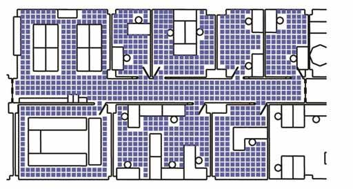
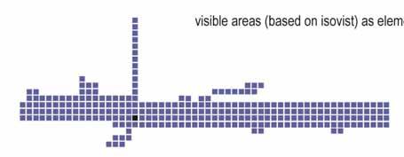
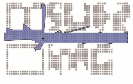
10 Architectural Space as a Network The Method of Space Syntax Floor plan Visual graph analysis Axial topology Metric topology Space usage, e.g. movement flow Integrated Segregated
11 Space Syntax Research: Comparative Analysis of Cities 1000m Part of Tokyo 500m Part of London Bill Hillier et al
12 10000m Architectural Space as a Network Bill Hillier et al LONDON and its region within the M25, with its strong centre and strong radials, but weak lateral connections between the radials Dr Kerstin Sailer, December 2012
13 BEIJING with its relative weak centre and weak radials, but strong lateral structure between radials 10000m Bill Hillier et al
14 Architectural Space as a Network 10000m Bill Hillier et al TOKYO with its fairly strong centre, strong radials and strong laterals, generating the strong sub-city structure characteristic of Tokyo Dr Kerstin Sailer, December 2012
15 Space Syntax Research: City Centres and Retail Activity Laura Vaughan, Sam Griffiths, Muki Haklay, Kate Jones

16 Space Syntax Research: Public Spaces Old Market Square, Nottingham Anna Rose / Space Syntax Ltd. Architectural Space as a Network Dr Kerstin Sailer, December 2012


17 Space Syntax Research: Public Spaces Old Market Square, Nottingham Anna Rose / Space Syntax Ltd.


18 Space Syntax Research: Museums Spatial configuration and movement flows at Tate Britain SOCIAL BEHAVIOURS Bill Hillier / Space Syntax Ltd.

19 Space Syntax Research: Libraries Movement flows in the British Library Movement flows on Upper Ground Floor Data collection by UCL MSc AAS students in 2009 and 2010 Readers Non-Readers

20 Space Syntax Research: Workplace Environments Movement flows in offices: result of configuration and attractor placement SOCIAL BEHAVIOURS Kerstin Sailer

21 From Spatial to Transpatial Solidarities: from Virtual to Real Communities SOCIAL BEHAVIOURS
22 Spatial and Transpatial Solidarities Concept of spatiality and transpatial solidarity as two distinct ways of creating relationships between individuals: In their elementary forms, in effect, buildings ( ) can define a relation to others by conceptual analogy, rather than spatial relation. The inhabitant of a house in a village, say, is related to his neighbours spatially, in that he occupies a location in relation to them, but also he relates to them conceptually, in that his interior system of spatialised categories is similar or different from those of his neighbours. He relates, it might be said, transpatially as well as spatially. (Hillier and Hanson 1984: 18ff) Key features of spatial and transpatial ordering of categories: Affinity between individuals spatially as well as transpatially driven Societies may use one way of ordering more than another Ordering of space not of equal conspicuousness to every culture
23 Spatial and Transpatial Solidarities SOCIAL SOLIDARITIES FORM Mechanic Organic ORGANISATIONAL OPERATIONS SPATIAL IMPLICATIONS Integration through similarity Homogeneity Long models, i.e. strongly programmed Hierarchies Vertical communication Transpatial Segregated and sparse space Interior relations, inside Well defined categorical differences between spaces High levels of control of events and encounter Interdependence through differentiation Heterogeneity Short models, i.e. weakly programmed Network Structure Lateral communication Spatial Integrated and dense space Exterior relations, outside Weakly defined categorical differences between spaces Low levels of control of events and encounter Sources: Durkheim 1893, Burns and Stalker 1961, Hillier and Hanson 1984, Hillier and Penn 1991; summarised in Sailer 2010

24 Spatial and Transpatial Solidarities Spatial Solidarities WHERE WE ARE Location, Neighbourhoods, Proximity, Physical Closeness Transpatial Solidarities WHO WE ARE Gender, Age, Profession, Affiliations, Memberships, Interests The Guildhall, City of London


25 Interplay between Spatial & Transpatial Example 1 Organisational Cultures in the British Museum High levels of local integration yet global segregation distinct org. cultures, segregated spaces allow transpatial identities to flourish


26 Interplay between Spatial & Transpatial Example 2 Lack of local identities in a Media Company Brands need to own their space and feel separate to other brands. If you walk around the office you would never know where you are unless you already know people. This doesn't enable people to make new friends or contacts. High levels of global integration and uniform workstation layout lack of identities, disregard of transpatial solidarities


27 Interplay between Spatial & Transpatial Example 3 Time-space routines and social cohesion in Research Institute High levels of global integration emergence of social cohesion and contacts fostered in transpatially organised clusters
28 Spatial and Transpatial Solidarities Two mechanisms for bonding and social relationships between people: 1. Sharing same local world and coming together in physical space (spatial solidarity); 2. Shared interests or goals, which may overcome / transverse boundaries of physical space (transpatial solidarity); SPATIAL TRANS- SPATIAL Example: The Guild Virtual Community Real Community


29 Impact of Technologies Physical and Virtual Spaces

30 Impact of Technologies Emergence of Online Communities Source:
31 Impact of Technologies Networked Individualism Networked Individualism (Rainie and Wellman 2012): People function as connected individuals; partial membership in multiple networks instead of permanent membership in settled groups; Made possible by: Social Network Revolution: opportunities to reach beyond tightly knit groups Internet Revolution: communication and information-gathering power Mobile Revolution: accessibility, anywhere and anytime PAST SOCIETY: fixed groups CURRENT / FUTURE SOCIETY: networked individualism KINSHIP WORK CHURCH Village / Town Various spatial scales
 OPTION 2: Go to")
32 Impact of Technologies: Physical and Digital Space How do people find information? Example: Rosetta Stone at British Museum OPTION 1: Travel to London, visit British Museum (physical space) OPTION 2: Go to website of the British Museum (digital space)
33 Impact of Technologies: Physical and Digital Space Finding information on Rosetta Stone at British Museum: Option 1 (physical space) Structured search: looking at map or asking information desk (2-3 steps) Exploratory: finding interesting / relevant exhibits on your own (2-10 steps, possibly more)
 [Exploratory: clicking through the online collections (3-10 steps,")
34 Impact of Technologies: Physical and Digital Space Finding information on Rosetta Stone at British Museum: Option 2 (digital space) Structured search: typing name of exhibit into search box (2 steps) [Exploratory: clicking through the online collections (3-10 steps, possibly more)]

35 Impact of Technologies: Physical and Digital Space Finding information on Rosetta Stone at British Museum different spatial experiences in physical & digital space, but also different social realities PHYSICAL SPACE DIGITAL SPACE
36 Impact of Technologies: Physical and Digital Space What is the difference between physical space and digital space in enabling the get together of people and allowing communities to flourish? PHYSICAL SPACE Complex spatial configuration Deep or shallow Relative position or location matters Distribution of users through spatial configuration / attractors Unplanned encounter Co-presence DIGITAL SPACE Simple or no spatial configuration at all Shallow / flat Access matters Distribution of users through access / self-selection process Structured encounter Lone activity
37 Conclusions Physical space in buildings and cities structures co-presence and interaction patterns of people; Co-presence of people in space gives rise to virtual community : raw material of society, awareness and psychological dimension; Communities emerge from the combination of spatial and transpatial worlds; Technologies change the way in which people interact, yet physical space remains an important dimension; Digital space allows online communities to flourish distinctly different from affordances of physical space and implications for social relationships; Similarly to Space Syntax which offers a language for discursive and structured analysis of physical space, an approach to systematically investigate the structure and affordances of digital spaces is needed
38 Thank you! Dr Kerstin Sailer Lecturer in Complex Buildings Bartlett School of Graduate Studies University College London 14 Upper Woburn Place London WC1H 0NN United Kingdom
Space Syntax: Architecture and Cities MRes This programme information sheet includes details of the structure and content of the course.
 Space Syntax: Architecture and Cities MRes 2018-19 This programme information sheet includes details of the structure and content of the course. CONTENTS Overview 3 Structure 4 Content 5 Staff 6 Opportunities
How Spatial Layout and Architecture Influence Everyday Work of Theoretical Physicists The Example of the mpipks
 How Spatial Layout and Architecture Influence Everyday Work of Theoretical Physicists The Example of the mpipks Dipl.-Ing. Kerstin Sailer Lehrstuhl Industriebau, TU Dresden Young Scientists Jam Session,
Spatial Layout and the Promotion of Innovation in Organizations
 Spatial Layout and the Promotion of Innovation in Organizations Jean Wineman, Felichism Kabo, Jason Owen-Smith, Gerald Davis University of Michigan, Ann Arbor, Michigan ABSTRACT: Research on the enabling
Chapter IV. Space Syntax
 61 Chapter IV Space Syntax 1 INTRODUCTION Space Syntax is an important component of this dissertation because it deals with topologically derived configuration and has techniques that allow the environment
Place Syntax Tool (PST)
") Place Syntax Tool (PST) Alexander Ståhle To cite this report: Alexander Ståhle (2012) Place Syntax Tool (PST), in Angela Hull, Cecília Silva and Luca Bertolini (Eds.) Accessibility Instruments for Planning
Place Syntax Tool (PST) Alexander Ståhle To cite this report: Alexander Ståhle (2012) Place Syntax Tool (PST), in Angela Hull, Cecília Silva and Luca Bertolini (Eds.) Accessibility Instruments for Planning
The Journal of Space Syntax
 The Journal of Space Syntax Editorial Sophia Psarra Reader of Architecture and Spatial Design The Bartlett School of Graduate Studies Faculty of the Built Environment University College London (UCL) 14
The population within the AMC limits was 4.5 million in 2001 (Census of India 2001). The Sabarmati River divides the city in two parts. The city s tra
. The Sabarmati River divides the city in two parts. The city s tra") EXPLORING THE RELATIONSHIP BETWEEN URBAN ROADS, URBAN FORM AND ECONOMIC ACTIVITY IN AHMEDABAD USING SPACE SYNTAX Arindam Majumdar 1, Richard Sliuzas 2, Talat Munshi 1, Mark Brussel 2 1 Center for Environmental
EXPLORING THE RELATIONSHIP BETWEEN URBAN ROADS, URBAN FORM AND ECONOMIC ACTIVITY IN AHMEDABAD USING SPACE SYNTAX Arindam Majumdar 1, Richard Sliuzas 2, Talat Munshi 1, Mark Brussel 2 1 Center for Environmental
Colleges of Cambridge: The Spatial Interaction between the Town and the Gown. Dima Srouri University College London, UK
 Colleges of Cambridge: The Spatial Interaction between the Town and the Gown Dima Srouri University College London, UK srourid@hotmail.com Abstract This paper investigates the notion of campus community
Public spaces revisted: a study of the relationship between patterns of stationary activity and visual fields
 Public spaces revisted: a study of the relationship between patterns of stationary activity and visual fields Abstract Maria Beatriz de Arruda Campos and Theresa Golka Space Syntax Limited, UK b.campos@spacesyntax.com,
Morphological Change of Dhaka City Over a Period of 55 Years: A Case Study of Two Wards
 Journal of Bangladesh Institute of Planners ISSN 2075-9363 Vol. 2, December 2009, pp. 30-38, Bangladesh Institute of Planners Morphological Change of Dhaka City Over a Period of 55 Years: A Case Study
Space Syntax: Spatial Integration Accessibility and Angular Segment Analysis by Metric Distance (ASAMeD)
") Space Syntax: Spatial Integration Accessibility and Angular Segment Analysis by Metric Distance (ASAMeD) Nadia Charalambous, Magda Mavridou To cite this report: Nadia Charalambous, Magda Mavridou (2012)
Space Syntax: Spatial Integration Accessibility and Angular Segment Analysis by Metric Distance (ASAMeD) Nadia Charalambous, Magda Mavridou To cite this report: Nadia Charalambous, Magda Mavridou (2012)
MORPHOLOGICAL STUDY OF A SMALL TOWN BARKUR IN COASTAL KARNATAKA, INDIA 2 METHODOLOGY
 2 METHODOLOGY The understanding of form as a process with underlying structure, distinguishing it from the physical characteristics of town form itself by which the potentials of the town structure are
Marking Scheme Field Work. 6 International Geography Olympiad. Brisbane
 Marking Scheme Field Work th 6 International Geography Olympiad Brisbane June 2006 Question - Map - 7 Marks Mark out of 4 and divide by 2 at the end. (Sample map was provided to markers.) Shading according
Intimate Infrastructures
 Intimate Infrastructures A social and spatial strategy for high-density design at a human scale By Natasha Reid Intimate Infrastructures Intimate Infrastructures A social and spatial strategy for high-density
Organizational constructs and the structure of space: A comparative study of office layouts 43
 Organizational constructs and the structure of space: A comparative study of office layouts 43 Mahbub Rashid and Craig Zimring Georgia Institute of Technology, USA Abstract In this paper, we present a
Declaration Population and culture
 Declaration Population and culture The ministers of the parties to the Alpine Convention regard the socio-economic and socio-cultural aspects mentioned in Article 2, Paragraph 2, Item a., as being central
Confeego: Tool Set for Spatial Configuration Studies
 14 Confeego: Tool Set for Spatial Configuration Studies Jorge Gil, Chris Stutz and Alain Chiaradia Space Syntax Limited, London, UK Abstract. Confeego is a suite of tools to understand and harness the
Application Issues in GIS: the UCL Centre for Advanced Spatial Analysis. Paul Longley UCL
 Application Issues in GIS: the UCL Centre for Advanced Spatial Analysis Paul Longley UCL GIS: inclusive, shared understanding Geodemographics as a focus of interest Profiling public goods and services
CONCEPTS OF GENETICS BY ROBERT BROOKER DOWNLOAD EBOOK : CONCEPTS OF GENETICS BY ROBERT BROOKER PDF
 CONCEPTS OF GENETICS BY ROBERT BROOKER DOWNLOAD EBOOK : CONCEPTS OF GENETICS BY ROBERT BROOKER PDF Click link bellow and free register to download ebook: CONCEPTS OF GENETICS BY ROBERT BROOKER DOWNLOAD
Application of Space Syntax as Presentation and Analysis Technique in the Study of Spatial Integration in Contoured Landform
 2012, TextRoad Publication ISSN 2090-4304 Journal of Basic and Applied Scientific Research www.textroad.com Application of Space Syntax as Presentation and Analysis Technique in the Study of Spatial Integration
Mapping Welsh Neighbourhood Types. Dr Scott Orford Wales Institute for Social and Economic Research, Data and Methods WISERD
 Mapping Welsh Neighbourhood Types Dr Scott Orford Wales Institute for Social and Economic Research, Data and Methods WISERD orfords@cardiff.ac.uk WISERD Established in 2008 and funded by the ESRC and HEFCW
USER PARTICIPATION IN HOUSING REGENERATION PROJECTS
 USER PARTICIPATION IN HOUSING REGENERATION PROJECTS Dr. Hatice Sadıkoğlu Bahçeşehir University, Faculty of Architecture and Design Prof. Dr. Ahsen Özsoy Istanbul Technical University, Faculty of Architecture
Urban Geography. Unit 7 - Settlement and Urbanization
 Urban Geography Unit 7 - Settlement and Urbanization Unit 7 is a logical extension of the population theme. In their analysis of the distribution of people on the earth s surface, students became aware
Exploring the Geography of Communities in Social Networks
 Exploring the Geography of Communities in Social Networks Alexis Comber 1, Michael Batty 2, Chris Brunsdon 3, Andrew Hudson-Smith 2, Fabian Neuhaus 2 and Steven Gray 2 1 Department of Geography, University
Key Issue 1: Where Are Services Distributed? INTRODUCING SERVICES AND SETTLEMENTS LEARNING OUTCOME DESCRIBE THE THREE TYPES OF SERVICES
 Revised 2017 NAME: PERIOD: Rubenstein: The Cultural Landscape (12 th edition) Chapter Twelve Services and Settlements (pages 430 thru 457) This is the primary means by which you will be taking notes this
UC Santa Barbara CSISS Classics
 UC Santa Barbara CSISS Classics Title Georg Simmel, The Sociology of Space. CSISS Classics Permalink https://escholarship.org/uc/item/7s73860q Author Fearon, David Publication Date 2004-01-01 escholarship.org
Road Network Analysis as a Means of Socio-spatial Investigation the CoMStaR 1 Project
 Road Network Analysis as a Means of Socio-spatial Investigation the CoMStaR 1 Project F. Anders 1, R. König 1 1 Bauhaus-University Weimar, Faculty of Architecture, Chair Computer Science in Architecture,
Keywords spatial configuration; spatial analysis; modeling; methodology; multi-layered space
 Exploring Multi-layered Hyper Dense Urban Environments through Spatial Analysis Ref 062 Stephen Law Space Syntax, Consultant, London, United Kingdom s.law@spacesyntax.com Yunfei Zhao Edaw-UCL, Geographical
Web Structure Mining Nodes, Links and Influence
 Web Structure Mining Nodes, Links and Influence 1 Outline 1. Importance of nodes 1. Centrality 2. Prestige 3. Page Rank 4. Hubs and Authority 5. Metrics comparison 2. Link analysis 3. Influence model 1.
Spatial analysis in an agent-based environment 16
 Squatter settlements consolidation: Spatial analysis in an agent-based environment 16 Fabiano Sobreira Faculdade de Ciências Humanas-ESUDA, Brazil Abstract In this present paper the development of inner-city
Affiliation Spatially Expressed: How Social Networks Structure Residential Mobilities in London
 Affiliation Spatially Expressed: How Social Networks Structure Residential Mobilities in London Anna Tuononen, Stephen Law UCL, Bartlett School of Architecture, London, United Kingdom anna.tuononen.15@ucl.ac.uk
The Livehoods Project: Utilizing social media to understand the dynamics of a city. Trung Phan
 The Livehoods Project: Utilizing social media to understand the dynamics of a city Trung Phan {tphan@idiap.ch} 1 Content 1 Introduction 2 Clustering 3 Interview 4 Result and Discussion 5 Conclusion 5/26/16
Internet Resource Guide. For Chemical Engineering Students at The Pennsylvania State University
 Internet Resource Guide For Chemical Engineering Students at The Pennsylvania State University Faith Tran 29 FEBRUARY 2016 Table of Contents 1 Front Matter 1.1 What is in the Guide... 2 1.2 Who this Guide
Integrated sub-regional planning informed by weighted spatial network models:
 Integrated sub-regional planning informed by weighted spatial network models: The case of Jeddah Kayvan Karimi Space Syntax Laboratory, The Bartlett School of Architecture, UCL k.karimi@ucl.ac.uk Ed Parham
Relationship between Spatial Configuration and Ferry, Bus and Railway Patronage in Brisbane CBD
 Relationship between Spatial Configuration and Ferry, Bus and Railway Patronage in Brisbane CBD Sima Vaez 1, Matthew Burke 2,Tooran Alizadeh 3 Email for correspondence: sima.vaezeslami@griffithuni.edu.au
Your web browser (Safari 7) is out of date. For more security, comfort and. the best experience on this site: Update your browser Ignore
 is out of date. For more security, comfort and. the best experience on this site: Update your browser Ignore") Your web browser (Safari 7) is out of date. For more security, comfort and Activityengage the best experience on this site: Update your browser Ignore Comparing Historical Maps How can historical maps
Your web browser (Safari 7) is out of date. For more security, comfort and Activityengage the best experience on this site: Update your browser Ignore Comparing Historical Maps How can historical maps
A Modified DBSCAN Clustering Method to Estimate Retail Centre Extent
 A Modified DBSCAN Clustering Method to Estimate Retail Centre Extent Michalis Pavlis 1, Les Dolega 1, Alex Singleton 1 1 University of Liverpool, Department of Geography and Planning, Roxby Building, Liverpool
Analysis of a high sub-centrality of peripheral areas at the global urban context
 Analysis of a high sub-centrality of peripheral areas at the global urban context Adriana Dantas Nogueira Universidade Federal de Sergipe, Brazil adriananogueira02@hotmail.com Abstract This paper presents
PhD in URBAN PLANNING, DESIGN, AND POLICY - 34th cycle
 PhD in URBAN PLANNING, DESIGN, AND POLICY - 34th cycle Research Field: THE MULTIPLE EFFECTS OF B2C E-COMMERCE GROWTH IN ITALY: RETAIL SYSTEM EVOLUTION AND SPATIAL IMPACT. Monthly net income of PhDscholarship
Online to Offline : Translating Media Usage To Real Life Public
 +Avivah Yamani +Indonesia langitselatan Online to Offline : Translating Media Usage To Real Life Public +Map of Indonesia Google map Indonesia is a tropical country with 17,508 island With a population
Using Social Media for Geodemographic Applications
 Using Social Media for Geodemographic Applications Muhammad Adnan and Guy Lansley Department of Geography, University College London @gisandtech @GuyLansley Web: http://www.uncertaintyofidentity.com Outline
The maps in this resource can be freely modified and reproduced in the classroom only.
 Teacher's Notes In this activity, students work collaboratively to explore sections of old and new maps. By closely examining these documents, students learn to see maps as more than just tools for locating
The Differentiating Behaviour of Shoppers Clustering of Individual Movement Traces in a Supermarket
 The Differentiating Behaviour of Shoppers Clustering of Individual Movement Traces in a Supermarket Ref 036 Jorge Gil Space Syntax, NA, London, United Kingdom j.gil@spacesyntax.com Eime Tobari Space Syntax,
COSMIC: COmplexity in Spatial dynamic
 COSMIC: COmplexity in Spatial dynamic MICs 9 10 November, Brussels Michael Batty University College London m.batty@ucl.ac.uk http://www.casa.ucl.ac.uk/ Outline The Focus of the Pilot The Partners: VU,
URBAN CONFIGURATIONAL COMPLEXITY
 P ROCEEDINGS VOLUME I COMPARATIVE CITIES URBAN CONFIGURATIONAL COMPLEXITY Definition and Measurement 05 Romûlo Krafta Federal University of Rio Grande do Sul, Porto Alegre, Brazil 0 Abstract Among the
Cities, AI, Design, & the Future Can Artificial Intelligence Improve Design Intelligence?
 March 27 th 28 Cities, AI, Design, & the Future Can Artificial Intelligence Improve Design Intelligence? Michael Batty m.batty@ucl.ac.uk @jmichaelbatty http://www.spatialcomplexcity.info/ http://www.casa.ucl.ac.uk/
Towards an Architectural Theory of Space and Organisations: Cognitive, Affective and Conative Relations in Workplaces
 Towards an Architectural Theory of Space and Organisations: Cognitive, Affective and Conative Relations in Workplaces Kerstin Sailer and Alan Penn The Bartlett School of Graduate Studies, University College
What is Human Geography? HUMAN GEOGRAPHY. Human Geography. Human Geography 5/18/2015. Example of Differences: Hurricane Katrina
 What is Human Geography? Geography is the science of place and space. Geographers ask: Where are things located? Why things are located where they are? How places differ from one another? How people interact
THE STRUCTURE OF PUBLIC SPACEIN SPARSELY URBAN AREAS
 O L U M E I I P R O C E E D I N G S VO O L U M E THE STRUCTURE OF PUBLIC SPACEIN SPARSELY URBAN AREAS Vaso Trova, Eleni Hadjinikolaou, Solon Xenopoulos, John Peponis School of Architecture, National Technical
RELATIONSHIP BETWEEN VISITORS MOVEMENT PATH, STAYING ACTIVITY AND SPATIAL STRUCTURE IN THE LIBRARY AS A THIRD PLACE :
 #26 RELATIONSHIP BETWEEN VISITORS MOVEMENT PATH, STAYING ACTIVITY AND SPATIAL STRUCTURE IN THE LIBRARY AS A THIRD PLACE : Focusing on Yamanashi prefectural library TAIGA SATO Graduate School of Science
Specified Issue. Pic3. Spring 2015
 Pic3 12 Pic1 11 Pic6 Pic2 10 Pic5 performance since structured streets and important buildings surround it. According to the distance index, the tissue is not too dense, while high-rise buildings are observed.
The Urbana Free Library Parking and Transportation Study
 CHAMPAIGN COUNTY REGIONAL PLANNING COMMISSION The Urbana Free Library Parking and Transportation Study Final Report 7/18/2013 Champaign Urbana Urbanized Area Transportation Study (CUUATS) TABLE OF CONTENTS
A Sketch of an Ontology of Spaces
 A Sketch of an Ontology of Spaces Pierre Grenon Knowledge Media Institute The Open University p.grenon@open.ac.uk Abstract. In these pages I merely attempt to sketch the basis of an ontology of spaces
M. Saraiva* 1 and J. Barros 1. * Keywords: Agent-Based Models, Urban Flows, Accessibility, Centrality.
 The AXS Model: an agent-based simulation model for urban flows M. Saraiva* 1 and J. Barros 1 1 Department of Geography, Birkbeck, University of London, 32 Tavistock Square, London, WC1H 9EZ *Email: m.saraiva@mail.bbk.ac.uk
Conflict between Space and Crime: Exploring the Relationship between Spatial Configuration and Crime Location
 Conflict between Space and Crime: Exploring the Relationship between Spatial Configuration and Crime Location Perver K. Baran NC State University William R. Smith NC State University Umut Toker California
from
 8Map Generalization and Classification Our human and natural environments are complex and full of detail. Maps work by strategically reducing detail and grouping phenomena together. Driven by your intent,
IS NEIGHBOURHOOD MEASURABLE?
 IS NEIGHBOURHOOD MEASURABLE? 088 Nick Sheep Dalton The Bartlett School of Graduate Studies, UCL Keywords: Neighbourhood Point intelligibility Point synergy Space Syntax Nick Sheep Dalton The Bartlett School
THE STANDARD MODEL IN A NUTSHELL BY DAVE GOLDBERG DOWNLOAD EBOOK : THE STANDARD MODEL IN A NUTSHELL BY DAVE GOLDBERG PDF
 Read Online and Download Ebook THE STANDARD MODEL IN A NUTSHELL BY DAVE GOLDBERG DOWNLOAD EBOOK : THE STANDARD MODEL IN A NUTSHELL BY DAVE Click link bellow and free register to download ebook: THE STANDARD
Social Exclusion and Digital Disengagement
 Social Exclusion and Digital Disengagement Issues of Policy, Theory and Measurement OxIS Discussion Seminar 2007 (OII) Ellen J. Helsper Bill Dutton Agenda Introduction Bill Dutton Director OII & Principal
Fuzzy Geographically Weighted Clustering
 Fuzzy Geographically Weighted Clustering G. A. Mason 1, R. D. Jacobson 2 1 University of Calgary, Dept. of Geography 2500 University Drive NW Calgary, AB, T2N 1N4 Telephone: +1 403 210 9723 Fax: +1 403
MODULE 1 INTRODUCING THE TOWNSHIP RENEWAL CHALLENGE
 MODULE 1 INTRODUCING THE TOWNSHIP RENEWAL CHALLENGE FOCUS OF THE MODULE Township renewal challenges and developmental outcomes covered in this module: Historical origins of townships and the inherited
Neighbourhood Planning in Haringey. Myddleton Road Strategic Group 7 th November 2013
 Neighbourhood Planning in Haringey Myddleton Road Strategic Group 7 th November 2013 What is Neighbourhood Planning? Neighbourhood Planning, introduced through the Localism Act 2011, offers an opportunity
Understanding consumption in Melbourne s multicultural society
 Understanding consumption in Melbourne s multicultural society ECOCITY WORLD SUMMIT 12-14 JULY 2017 Dr. Christina YP Ting Prof. Peter Newton Asso. Prof. Wendy Stone Centre for Urban Transitions Swinburne
Grade 6 Social Studies
 Unit Title: Africa : Movement Location Place Human Region : Subject/Course: 6 th Grade Social Studies Essential Questions: peoples, cultures and ideas of the world? How is a location identified using map
A Computable Language of Architecture
 A Computable Language of Architecture Description of Descriptor Language in Supporting Compound Definitions Introduction Sora Key Carnegie Mellon University, Computational Design Laboratory, USA http://www.code.arc.cmu.edu
Looking at Communities: Comparing Urban and Rural Neighborhoods
 Looking at Communities: Comparing Urban and Rural Neighborhoods OVERVIEW & OBJECTIVES Our urban areas have become so dominant that frequently the children we teach have no connection with and very few
Location does not matter in the informational age? a case study on the distribution of restaurants listed in dazhongdianping in Beijing
 Beijing City Lab SHENG Qiang, LI Miaoyi, ZHANG Xingyi, 2015, Location does not matter in the informational age? a case study on the distribution of restaurants listed in dazhongdianping in Beijing. Beijing
THE TOURIST AND THE CITY.
 THE TOURIST AND THE CITY. ON ORIENTATION IN UNKNOWN URBAN SPACE Anna Agata Kantarek D.Sc. Ph.D. Arch. Faculty of Architecture Cracow University of Technology 6TH CONFERENCE OF THE INTERNATIONAL FORUM ON
Profiling Burglary in London using Geodemographics
 Profiling Burglary in London using Geodemographics C G Gale *1, A D Singleton 2 and P A Longley 3 1 UCL Department of Civil, Environmental & Geomatic Engineering 2 University of Liverpool Department of
Modelling Spatial Behaviour in Music Festivals Using Mobile Generated Data and Machine Learning
 Modelling Spatial Behaviour in Music Festivals Using Mobile Generated Data and Machine Learning Luis Francisco Mejia Garcia *1, Guy Lansley 2 and Ben Calnan 3 1 Department of Civil, Environmental & Geomatic
East Bay BRT. Planning for Bus Rapid Transit
 East Bay BRT Planning for Bus Rapid Transit Regional Vision Draper Prison The Bottleneck is a State-Level issue, Salt Lake County 2050 Population: 1.5M Draper Prison hopefully with some State-Level funding!
CSI 445/660 Part 3 (Networks and their Surrounding Contexts)
") CSI 445/660 Part 3 (Networks and their Surrounding Contexts) Ref: Chapter 4 of [Easley & Kleinberg]. 3 1 / 33 External Factors ffecting Network Evolution Homophily: basic principle: We tend to be similar
CSI 445/660 Part 3 (Networks and their Surrounding Contexts) Ref: Chapter 4 of [Easley & Kleinberg]. 3 1 / 33 External Factors ffecting Network Evolution Homophily: basic principle: We tend to be similar
Geographical knowledge and understanding scope and sequence: Foundation to Year 10
 Geographical knowledge and understanding scope and sequence: Foundation to Year 10 Foundation Year 1 Year 2 Year 3 Year 4 Year 5 Year 6 Year level focus People live in places Places have distinctive features
A new metric of crime hotspots for Operational Policing
 A new metric of crime hotspots for Operational Policing Monsuru Adepeju *1, Tao Cheng 1, John Shawe-Taylor 2, Kate Bowers 3 1 SpaceTimeLab for Big Data Analytics, Department of Civil, Environmental and
Estimating Large Scale Population Movement ML Dublin Meetup
 Deutsche Bank COO Chief Data Office Estimating Large Scale Population Movement ML Dublin Meetup John Doyle PhD Assistant Vice President CDO Research & Development Science & Innovation john.doyle@db.com
Many Ways to Name a Place
 Your web browser (Safari 7) is out of date. For more security, comfort and Activityapply the best experience on this site: Update your browser Ignore Many Ways to Name a Place What are the names for the
LOCATION, SPACE AND TIME IN GEOGRAPHY
 LOCATION, SPACE AND TIME IN GEOGRAPHY Component-I(A) - Personal Details Chand Sultana Role Name Affiliation Principal Investigator Prof. Masood Ahsan Siddiqui Department of Geography, Jamia Millia Islamia,
SALES AND MARKETING Department MATHEMATICS. 2nd Semester. Bivariate statistics. Tutorials and exercises
 SALES AND MARKETING Department MATHEMATICS 2nd Semester Bivariate statistics Tutorials and exercises Online document: http://jff-dut-tc.weebly.com section DUT Maths S2. IUT de Saint-Etienne Département
Space Syntax A Tool For Understanding Spatial Organization and its Change Over Time. Dr Abir Bandyopadhyay National Institute of Technology, Raipur
 Space Syntax A Tool For Understanding Spatial Organization and its Change Over Time Dr Abir Bandyopadhyay National Institute of Technology, Raipur In the 15 th Century, many European communities came to
Neighborhood Locations and Amenities
 University of Maryland School of Architecture, Planning and Preservation Fall, 2014 Neighborhood Locations and Amenities Authors: Cole Greene Jacob Johnson Maha Tariq Under the Supervision of: Dr. Chao
Part-time spaces: rethinking belonging in HE
 Part-time spaces: rethinking belonging in HE Enduring Inequalities and New Agendas for Widening Participation in Higher Education: Student Access, Mobilities and Success 27 July 2016, University of Leeds
RURAL SETTLEMENT PATTERNS AND ACCESS TO DEVELOPMENT LAND: DEVELOPING THE EVIDENCE BASE
 School of Planning, Architecture and Civil Engineering RURAL SETTLEMENT PATTERNS AND ACCESS TO DEVELOPMENT LAND: DEVELOPING THE EVIDENCE BASE Prepared for Friends of the Earth Northern Ireland 18 th April
Ref 009 Visibility and Permeability Complementary Syntactical Attributes of Wayfinding
 Short Paper Ref 009 Visibility and Permeability Complementary Syntactical Attributes of Wayfinding Mateus Paulo Beck Ufrgs, Propar, Porto Alegre, Brazil mateuspbeck@gmail.com Benamy Turkienicz Ufrgs, Propar,
Space syntax analysis methodology of understanding the space
 Space syntax analysis methodology of understanding the space Weronika DETTLAFF Keywords: Space Syntax; way finding; spatial configuration; individual; spatial decision making Abstract: Nowadays space is
2014/15 Annual review of the Meteorological Service of New Zealand Limited
 2014/15 Annual review of the Meteorological Service of New Zealand Limited Report of the Commerce Committee Contents Recommendation 2 Introduction 2 Financial performance 2 Social media strategy 2 Improving
High speed network in Hauts-de-France Region. Värnamo, 17 th May 2018
 High speed network in Hauts-de-France Region Värnamo, 17 th May 2018 Hauts-de-France at the crossroads of the North-West Europe High speed train approach in France In the 1980s: will to link the main cities
Concept of Night City: A New Dimension To A City s Economy
 Concept of Night City: A New Dimension To A City s Economy Center for Town and Regional Planning Studies, Universiti Teknologi MARA, 40450 Shah Alam, Malaysia saniahzaki@salam.uitm.edu.my ABSTRACT As an
Belfairs Academy GEOGRAPHY Fundamentals Map
 YEAR 12 Fundamentals Unit 1 Contemporary Urban Places Urbanisation Urbanisation and its importance in human affairs. Global patterns of urbanisation since 1945. Urbanisation, suburbanisation, counter-urbanisation,
STAGE 2 GEOGRAPHY: Natural environments
 STAGE 2 GEOGRAPHY: Natural environments Focus area: The Earth s environment Different environments Significance of environments Key inquiry questions How does the environment support the lives of people
JULIE A. PELTON Curriculum Vita
 JULIE A. PELTON Curriculum Vita University of Nebraska at Omaha Department of Sociology & Anthropology ASH 383 M Omaha, NE 68182 email: jpelton@unomaha.edu phone: (402) 554-4125 EDUCATION The Pennsylvania
Your web browser (Safari 7) is out of date. For more security, comfort and. the best experience on this site: Update your browser Ignore
 is out of date. For more security, comfort and. the best experience on this site: Update your browser Ignore") Your web browser (Safari 7) is out of date. For more security, comfort and Activityengage the best experience on this site: Update your browser Ignore Introduction to GIS What is a geographic information
Your web browser (Safari 7) is out of date. For more security, comfort and Activityengage the best experience on this site: Update your browser Ignore Introduction to GIS What is a geographic information
Spatial Configuration and Social Life for People Experiencing Dementia
 Spatial Configuration and Social Life for People Experiencing Dementia Keith Diaz Moore, Farhana Ferdous University of Kansas, Lawrence, KS ABSTRACT: In this paper, we will focus on the important, facilitating
P. O. Box 5043, 2600 CR Delft, the Netherlands, Building, Pokfulam Road, Hong Kong,
 THE THEORY OF THE NATURAL URBAN TRANSFORMATION PROCESS: THE RELATIONSHIP BETWEEN STREET NETWORK CONFIGURATION, DENSITY AND DEGREE OF FUNCTION MIXTURE OF BUILT ENVIRONMENTS Akkelies van Nes 1, Yu Ye 2 1
Pearson Education Limited Edinburgh Gate Harlow Essex CM20 2JE England and Associated Companies throughout the world
 Pearson Education Limited Edinburgh Gate Harlow Essex CM20 2JE England and Associated Companies throughout the world Visit us on the World Wide Web at: www.pearsoned.co.uk Pearson Education Limited 2014
It is clearly necessary to introduce some of the difficulties of defining rural and
 UNIT 2 CHANGING HUMAN ENVIRONMENTS G2 Theme 2 Investigating Settlement Change in MEDCs 2.1 What are the distinctive features of settlements? It is clearly necessary to introduce some of the difficulties
Third Grade Social Studies Indicators Class Summary
 History Standard Construct time lines to demonstrate an understanding of units of time and chronological order. 1. Define and measure time by years, decades and centuries. 2. Place local historical events
Information Needs & Information Seeking in Internet Era: A Case Study of Geographers in Maharashtra
 International Journal of Research in Library Science ISSN: 2455-104X Indexed in: IIJIF, ijindex, SJIF,ISI Volume 2,Issue 1 (January-June) 2016,99-108 Received: 7 May 2016 ; Accepted: 12 May 2016 ; Published:
Historical Maps Of Ireland By Michael Swift
 Historical Maps Of Ireland By Michael Swift If you are looking for a book by Michael Swift Historical Maps of Ireland in pdf form, in that case you come on to loyal website. We present utter variation
Housing visual quality in urban pattern; Application of isovist method in old fabric of Bushehr city
 International Journal of Architectural Engineering & Urban Planning Housing visual quality in urban pattern; Application of isovist method in old fabric of Bushehr city M. Alalhesabi 1,*, S. B. Hosseini
GOVERNMENT MAPPING WORKSHOP RECOVER Edmonton s Urban Wellness Plan Mapping Workshop December 4, 2017
 GOVERNMENT MAPPING WORKSHOP 12.4.17 RECOVER Edmonton s Urban Wellness Plan Mapping Workshop December 4, 2017 In July of 2017, City Council directed administration to develop RECOVER, Edmonton s Urban Wellness