UCL CENTRE FOR ADVANCED SPATIAL ANALYSIS. Mapping London. Oliver O Brien and James Cheshire. Society of Cartographers 48 th Annual Conference (UCL)
|
|
|
- Arline Harvey
- 6 years ago
- Views:
Transcription


1 UCL CENTRE FOR ADVANCED SPATIAL ANALYSIS Mapping London Oliver O Brien and James Cheshire Society of Cartographers 48 th Annual Conference (UCL) 5 September 2012


 Mapping London")

2 The Mapping London Blog A blog highlighting the best London maps Not to be confused with: London Mapping Festival London in Maps (book) Mapping London (book) London Mapper (forthcoming project showing demographic cartograms)
3 mappinglondon.co.uk Launched March 2011 Featured 87 maps so far We take turns to feature maps we discover Aim to feature new, mainly online content rather than just focusing on the (huge) number of old maps of London Almost all content featured so far is >1900.


4 Mapping London Aim to showcase the map, not dissect it Normally only a short amount of commentary about the map Normally feature a closeup of the map highlighting its cartography, rather than the whole map


5 Occasionally not a map
6 Themes Transport: 31 Visualisation: 31 Infographics: 13 Demographics: 12 Events: 12 Historic: 12 Data: 9 Policy: 4 Art: 3 N.B. Some maps appear in more than one category.


7 Historic or New? Both.
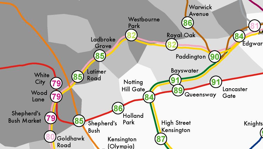
8 Tube Maps Trying not to have every other featured map being an adaptation of the tube map, but


9 Tube-Style Maps

10 Ollie s 3 Favourite Maps

11 Ollie s 3 Favourite Maps

12 Ollie s 3 Favourite Maps

13 Bonus Favourite Map (Not Yet Featured)

14 James 3 Favourite Maps

15 James 3 Favourite Maps

16 James 3 Favourite Maps
17 The Most Popular Maps on Mapping London Olympic Park Map (39k & 8k) Massive spike (11k) on Friday 20 July Jenni Sparks Hand Drawn Map of London (24k) Thanks to a mention from Londonist Mapped: Every Bus Trip in London (9k) London: A Year in Maps 2011 summary (8k) Mapping London s Underground Rivers (5k) TfL s Why Not Walk It Maps (5kK)


18 How People Find Mapping London
19 Our Own Work Also an output for some of our own maps Cartography by James Cheshire Website by Oliver O Brien
20 names.mappinglondon.co.uk London Surnames Launched March 2011 Second wave of media interest August 2012 The map shows the 15 most frequent surnames in each Middle Super Output Area across Greater London. The colours represent the origin of the surname (*not necessarily* the person) derived from UCL s Onomap Classification tool. The surnames have also been scaled by their total frequency in each MSOA.

21
22 names.mappinglondon.co.uk London version of a National Geographic infographic map produced in-house with James Ph.D data

23

24
25 names.mappinglondon.co.uk Striking patterns appear, particularly when viewing the No. 1 name Distinct clustering of surnames with Bangladeshi, Indian, Pakistani Sikh, Jewish and English names. Some correlation with borough boundaries Tower Hamlets: Bangladeshi Waltham Forest (southern half): Pakistani Begum actually a Bangladeshi honorific for wives Welsh surnames not necessarily Welsh people Data from the full electoral roll c
26 life.mappinglondon.co.uk Lives on the Line Life Expectancy at Birth and Child Poverty as a Tube Map Launched July 2012 Extending the popular tube/river map to show two sets of potentially correlated demographic data together Based on geographically accurate tube map Thames from OpenStreetMap

27 life.mappinglondon.co.uk Cheshire, J A. Lives on the Line: Mapping Life Expectancy Along the London Tube Network. Environment and Planning A 44(7). Doi: /a45341.

28
29
30 Plans Continue to feature maps roughly once a week Produce and feature more of our own maps Using the excellent resources at UCL CASA Feature more maps by colleagues Create more mapping mini-sites
31 Tips Wanted Tips are always welcome Let us know by (coming up) We also have a Twitter account for Mapping

32 Samples Grand Map of London A Guide to London 1908 Arty Globe: A Quirky View of London Tube Map Tape Times Atlas of London A New Map of London Peculiars Tweets in London A-Z London 2012 Map TfL s Why Not Walk It Maps Typographic Tube Map A Week in the Life of the Underground


33 Thanks mappinglondon.co.uk Oliver O Brien ollie [at] mappinglondon.co.uk James Cheshire james [at] mappinglondon.co.uk
34 Acknowledgements Almost all the maps featured here are the copyright of their creators please see the corresponding entry on the Mapping London blog for full attribution information. Various maps contain OpenStreetMap data (CC-By-SA OpenStreetMap contributors) and/or Ordnance Survey data which is Crown Copyright. The infographic on the fifth page was created by Jon Reades with TfL data. What s in a Surname (US) was designed by National Geographic Magazine.
Mapping Travel-To-Work Flows. Oliver O Brien and James Cheshire Department of Geography, UCL
 Mapping Travel-To-Work Flows Oliver O Brien and James Cheshire Department of Geography, UCL RSAI-BIS Annual Conference (UKDS-CS Sessions), Harrogate, 23 August 2017 Contents 1. The DataShine Project &
Using Social Media for Geodemographic Applications
 Using Social Media for Geodemographic Applications Muhammad Adnan and Guy Lansley Department of Geography, University College London @gisandtech @GuyLansley Web: http://www.uncertaintyofidentity.com Outline
National Geographic Map - Switzerland, Austria And Northern Italy By National Geographic Society
 National Geographic Map - Switzerland, Austria And Northern Italy By National Geographic Society If looking for a book National Geographic Map - Switzerland, Austria and Northern Italy by National Geographic
DataShine Automated Thematic Mapping of 2011 Census Quick Statistics
 DataShine Automated Thematic Mapping of 2011 Census Quick Statistics Oliver O Brien, James Cheshire Department of Geography University College London UKDS Census Applications Conference, July 2015 Contents
1. Richard Milton 2. Steven Gray 3. Oliver O Brien Centre for Advanced Spatial Analysis (UCL)
") UCL CENTRE FOR ADVANCED SPATIAL ANALYSIS Apps Delivering Information to Mass Audiences 1. Richard Milton 2. Steven Gray 3. Oliver O Brien Centre for Advanced Spatial Analysis (UCL) Scott Adams 1995 The
UCL CENTRE FOR ADVANCED SPATIAL ANALYSIS Apps Delivering Information to Mass Audiences 1. Richard Milton 2. Steven Gray 3. Oliver O Brien Centre for Advanced Spatial Analysis (UCL) Scott Adams 1995 The
A Guide to Census Geography
 Research Briefing 2013-05 July 2013 A Guide to Census Geography Contents 1 About this Briefing... 3 2 Sub Ward Geography... 3 3 The Geographical Hierarchies... 3 4 The Statistical Hierarchy... 4 5 Nesting...
Studying Geography: Tools of the Trade
 GEOG 101 TUTORING AVAILABLE Free tutoring is available to all GEOG 101 students by experienced teachers. No appointment is necessary. Walk in/walk out sessions. Bring your notes, textbook, handouts, and
Book Review: A Social Atlas of Europe
 Book Review: A Social Atlas of Europe Ferreira, J Author post-print (accepted) deposited by Coventry University s Repository Original citation & hyperlink: Ferreira, J 2015, 'Book Review: A Social Atlas
Explore. history landscapes family.
 Explore history landscapes family www.explorethepast.co.uk Contents From the team Section 1 Researching Worcestershire Section 2 Local Studies & Archaeology Reference Library Section 3 Maps and plans Accessing
Penguin Road Map: Victoria By Cartography Penguin
 Penguin Road Map: Victoria By Cartography Penguin If you are searching for a ebook Penguin Road Map: Victoria by Cartography Penguin in pdf format, in that case you come on to the loyal website. We furnish
GLA small area population projection methodology
 Update 2017-04 GLA small area population projection methodology 2015-based projections February 2017 Introduction The GLA produces a range of annually updated demographic projections for London. Among
Hennig, B.D. and Dorling, D. (2014) Mapping Inequalities in London, Bulletin of the Society of Cartographers, 47, 1&2,
 Mapping Inequalities in London, Bulletin of the Society of Cartographers, 47, 1&2,") Hennig, B.D. and Dorling, D. (2014) Mapping Inequalities in London, Bulletin of the Society of Cartographers, 47, 1&2, 21-28. Pre- publication draft without figures Mapping London using cartograms The
Hennig, B.D. and Dorling, D. (2014) Mapping Inequalities in London, Bulletin of the Society of Cartographers, 47, 1&2, 21-28. Pre- publication draft without figures Mapping London using cartograms The
A level Geography. WG6 Induction 2015
 A level Geography WG6 Induction 2015 What general employment skills will A level Geography give you? A good communicator with strong presentation skills Competent IT skills An independent researcher Able
The Scope and Growth of Spatial Analysis in the Social Sciences
 context. 2 We applied these search terms to six online bibliographic indexes of social science Completed as part of the CSISS literature search initiative on November 18, 2003 The Scope and Growth of Spatial
Spotlight on Population Resources for Geography Teachers. Pat Beeson, Education Services, Australian Bureau of Statistics
 Spotlight on Population Resources for Geography Teachers Pat Beeson, Education Services, Australian Bureau of Statistics Population Population size Distribution Age Structure Ethnic composition Gender
Early College High School PreAP World Geography Summer Reading Assignment
 Early College High School PreAP World Geography Summer Reading Assignment In preparation for your studies in World Geography you will be familiarizing yourself with the 5 Themes of Geography. This assignment
Welcome to Colouring London
 Welcome to Colouring London Login/Sign up Get started Year 2000-2017 1980-1999 1960-1979 1940-1959 1920-1939 1900-1919 1880-1899 1860-1879 1840-1859 1820-1839 1800-1819 1780-1799 1760-1779 1740-1759 1720-1739
Letter STUDENT NUMBER GEOGRAPHY. Written examination. Thursday 16 November 2017
 Victorian Certificate of Education 2017 SUPERVISOR TO ATTACH PROCESSING LABEL HERE Letter STUDENT NUMBER GEOGRAPHY Written examination Thursday 16 November 2017 Reading time: 3.00 pm to 3.15 pm (15 minutes)
SocViz: Visualization of Facebook Data
 SocViz: Visualization of Facebook Data Abhinav S Bhatele Department of Computer Science University of Illinois at Urbana Champaign Urbana, IL 61801 USA bhatele2@uiuc.edu Kyratso Karahalios Department of
9/7/ Studying Geography: Introduction to Mapping. Cartographic Terms. Cartographic Terms. Geographers Tools. Geographers Needs.
 Geographers Tools Studying Geography: Introduction to Mapping Prof. Anthony Grande Hunter College Geography Lecture design, content and presentation AFG0918. Individual images and illustrations may be
Overview. GIS Data Output Methods
 Overview GIS Output Formats ENV208/ENV508 Applied GIS Week 2: Making maps, data visualisation, and GIS output GIS Output Map Making Types of Maps Key Elements Table Graph Statistics Maps Map Making Maps
ENV208/ENV508 Applied GIS. Week 2: Making maps, data visualisation, and GIS output
 ENV208/ENV508 Applied GIS Week 2: Making maps, data visualisation, and GIS output Overview GIS Output Map Making Types of Maps Key Elements GIS Output Formats Table Graph Statistics Maps Map Making Maps
Kentucky Indians (Paperback) (Native American Heritage) By Carole Marsh
 (Native American Heritage) By Carole Marsh") Kentucky Indians (Paperback) (Native American Heritage) By Carole Marsh If searching for a ebook by Carole Marsh Kentucky Indians (Paperback) (Native American Heritage) in pdf format, then you've come
Kentucky Indians (Paperback) (Native American Heritage) By Carole Marsh If searching for a ebook by Carole Marsh Kentucky Indians (Paperback) (Native American Heritage) in pdf format, then you've come
United States Executive [Tubed] (National Geographic Reference Map) By National Geographic Maps - Reference
![United States Executive [Tubed] (National Geographic Reference Map) By National Geographic Maps - Reference](/thumbs/73/68492667.jpg "United States Executive [Tubed] (National Geographic Reference Map) By National Geographic Maps - Reference") United States Executive [Tubed] (National Geographic Reference Map) By National Geographic Maps - Reference World Executive Poster Sized Wall Map Tubed World - Download United States Executive Poster Size
United States Executive [Tubed] (National Geographic Reference Map) By National Geographic Maps - Reference World Executive Poster Sized Wall Map Tubed World - Download United States Executive Poster Size
National Geographic Geography Bee Study Guide
 We have made it easy for you to find a PDF Ebooks without any digging. And by having access to our ebooks online or by storing it on your computer, you have convenient answers with national geographic
3/4/2010. ESRI Education Community. CommunityWeb Mapping Tools
 Sketch-A-Map Reading, Writing and Math from a Different Perspective Education Community at ESRI Web Mapping Tools ESRI Education Community http://edcommunity.esri.com CommunityWeb Mapping Tools http://edcommunity.esri.com/maps/index.cfm
Historical Maps Of Ireland By Michael Swift
 Historical Maps Of Ireland By Michael Swift If you are looking for a book by Michael Swift Historical Maps of Ireland in pdf form, in that case you come on to loyal website. We present utter variation
Understanding and accessing 2011 census aggregate data
 Understanding and accessing 2011 census aggregate data 4 July 11:00 to 16:00 BST Justin Hayes and Richard Wiseman UK Data Service Census Support UK censuses provide an unparalleled resource of high quality
Smart Cities & Big Data How We Can Make Cities More Resilient
 July 15 th 19 th 2012 University College Dublin Smart Cities & Big Data How We Can Make Cities More Resilient Michael Batty m.batty@ucl.ac.uk @jmichaelbatty http://www.spatialcomplexity.info/ http://www.casa.ucl.ac.uk/
4 Studying Geography:
 4 Studying Geography: Introduction to Mapping Prof. Anthony Grande Hunter College Geography Lecture design, content and presentation AFG0119 Individual images and illustrations may be subject to prior
A new type of RICEPOTS
 A new type of RICEPOTS Alan Parkinson Geography teaching resource College Crown Copyright and Database Right 2014. Ordnance Survey (Digimap Licence) This is one of a series of teaching resources for use
Department Of Geography. MSc Applied GIS.
 Department Of Geography. MSc Applied GIS. This is a really exciting time to be in GIS, with new tools and new software allowing the application of GIS techniques to an ever-increasing range of fields.
Week 2: MAPS! Intro to Geography Lehman College GEH 101/GEH 501 Fall Source: Keith Miyake. Friday, September 9, 11
 1 Week 2: MAPS! Intro to Geography Lehman College GEH 101/GEH 501 Fall 2010 Keith Miyake Source: http://xkcd.com/256/ 2 Term Papers: Intro The purpose of this paper is to help students relate the geographical
MAKING MAPS Cartographic Design & Principles Winter 2018
 MAKING MAPS Cartographic Design & Principles Winter 2018 Cartography the art, science, and technology of making maps, together with their study as scientific documents and works of art - The International
Expected Learning Objective Activities/FAs Planned. Explain different values and responsibilitities one learns from one's family.
 The Orchid School Baner Syllabus Overview 2015-2016 Std : IV Subject : Social science Month Lesson / Content / Name of the Book Expected Learning Objective Activities/FAs Planned Changes in a Family Explain
Integrated Modelling of the Spatial Impacts of Climate Change In Greater London
 Megacities, Vulnerability and Global Climate Change: FAPESP: City of São Paulo, July 20 th 22 nd 2009 Integrated Modelling of the Spatial Impacts of Climate Change In Greater London Michael Batty University
Kenya Map: Regional Wall Map
 Kenya Map: Regional Wall Map If searched for the book Kenya Map: Regional Wall Map in pdf form, then you have come on to the loyal site. We furnish the complete option of this ebook in txt, PDF, DjVu,
Exploring Nature With Children A Guided Journal Families Print Edition by Lynn Seddon
 Exploring Nature With Children A Guided Journal Families Print Edition by Lynn Seddon If a child is to keep alive his inborn sense of wonder without any such gift from the fairies, he needs the companionship
Paper 3F: Reading and Understanding in Chinese
 Write your name here Surname Other names Pearson Edexcel GSE entre Number andidate Number hinese Paper 3F: Reading and Understanding in hinese Friday 23 May 2014 fternoon Time: 45 minutes You do not need
UCL Institute for Environmental Design and Engineering
 Heat Risk in London Group Meeting Monday 5 th February 2018, TfL, The International Quarter, London ONGOING AND FUTURE WORK Mapping heat vulnerability in London Dr Anna Mavrogianni Senior Lecturer in Sustainable
R I A H O U S E THE SUPPLY SIDE OF THE ON-LINE COMMERICAL SEX MARKET IN MASSACHUSETTS: A DATA MINING STUDY J
 R I A H O U S E THE SUPPLY SIDE OF THE ON-LINE COMMERICAL SEX MARKET IN MASSACHUSETTS: A DATA MINING STUDY J JANUARY 2016 H E A T H E R W I G H T M A N, M S W, M P H, R I A H O U S E, I n c. P A O L A
Map reading made easy
 Map reading made easy Maps can be great fun and they can lead you to all sorts of discoveries. They can help you get to know an area really well, because they pinpoint interesting places that are often
1. Origins of Geography
 II. ORIGINS AND BRANCHES OF GEOGRAPHY My Notes A. Origins of Geography Unit One 6 Before carefully examining the tools of the geographer, it would be useful to examine the origins and roots of this ancient
Compact guides GISCO. Geographic information system of the Commission
 Compact guides GISCO Geographic information system of the Commission What is GISCO? GISCO, the Geographic Information System of the COmmission, is a permanent service of Eurostat that fulfils the requirements
INFS 321 Information Sources
 INFS 321 Information Sources Session 7 Geographical Sources Lecturer: Prof. Perpetua S. Dadzie, DIS Contact Information: pdadzie@ug.edu.gh College of Education School of Continuing and Distance Education
Antarctica: A Guide To The Wildlife, 3rd (Bradt Guides) 3rd Edition By Soper, Tony (2001) Paperback By Tony Soper
 3rd Edition By Soper, Tony (2001) Paperback By Tony Soper") Antarctica: A Guide To The Wildlife, 3rd (Bradt Guides) 3rd Edition By Soper, Tony (2001) Paperback By Tony Soper Antarctica Travel Guide Travel + Leisure - My greatest fear before going to Antarctica
Antarctica: A Guide To The Wildlife, 3rd (Bradt Guides) 3rd Edition By Soper, Tony (2001) Paperback By Tony Soper Antarctica Travel Guide Travel + Leisure - My greatest fear before going to Antarctica
Astrology: Understanding The Birth Chart By Kevin Burk READ ONLINE
 Astrology: Understanding The Birth Chart By Kevin Burk READ ONLINE If you are searching for a ebook Astrology: Understanding the Birth Chart by Kevin Burk in pdf form, then you have come on to the right
Vanuatu Country Map By Hema By Hema Maps
 Vanuatu Country Map By Hema By Hema Maps If searched for a book by Hema Maps Vanuatu Country Map by Hema in pdf format, then you have come on to right website. We present the full release of this ebook
SKILLS (MA State Standards/Learning Outcomes)
") BRISCOE MIDDLE SCHOOL, BEVERLY, MA SOCIAL STUDIES CURRICULUM MAP & PACING GUIDE REVISED: JUNE 2012 GRADE 7 AUTHORS & GRADE-7 TEACHERS: Mr. Brian Bayer-Larson/Ms. Joy Benosky/Mr. Adam Olbash SEPTEMBER OCTOBER
BRISCOE MIDDLE SCHOOL, BEVERLY, MA SOCIAL STUDIES CURRICULUM MAP & PACING GUIDE REVISED: JUNE 2012 GRADE 7 AUTHORS & GRADE-7 TEACHERS: Mr. Brian Bayer-Larson/Ms. Joy Benosky/Mr. Adam Olbash SEPTEMBER OCTOBER
DOWNLOAD OR READ : PRAGUE CAPITAL OF THE TWENTIETH CENTURY PDF EBOOK EPUB MOBI
 DOWNLOAD OR READ : PRAGUE CAPITAL OF THE TWENTIETH CENTURY PDF EBOOK EPUB MOBI Page 1 Page 2 prague capital of the twentieth century prague capital of the pdf prague capital of the twentieth century Pragueâ
Geographical Inequalities and Population Change in Britain,
 Geographical Inequalities and Population Change in Britain, 1971-2011 Chris Lloyd, Nick Bearman, Gemma Catney Centre for Spatial Demographics Research, University of Liverpool, UK Email: c.d.lloyd@liverpool.ac.uk
2011 Ireland National Geographic Calendar By Zebra Publishing Corp. READ ONLINE
 2011 Ireland National Geographic Calendar By Zebra Publishing Corp. READ ONLINE View Don Johnston's professional profile on LinkedIn. National Geographic 2015 calendars Zebra Publishing December 2011.
Exploring Nature With Children A Guided Journal Cursive Edition by Lynn Seddon
 Exploring Nature With Children A Guided Journal Cursive Edition by Lynn Seddon Table of Contents Cursive Edition Getting started: notes for parents on how to use this journal 6 Autumn 8 September Seeds
A Land Use Transport Model for Greater London:
 Spatio-Temporal Analysis of Network Data and Road Developments Launch Event Workshop UCL Monday 18 May 2009 A Land Use Transport Model for Greater London: With Applications to an Integrated Assessment
National Geographic Australia: Continent Maps (NG Continent Maps) By National Geographic Society READ ONLINE
 By National Geographic Society READ ONLINE") National Geographic Australia: Continent Maps (NG Continent Maps) By National Geographic Society READ ONLINE If you are searching for a ebook by National Geographic Society National Geographic Australia:
National Geographic Australia: Continent Maps (NG Continent Maps) By National Geographic Society READ ONLINE If you are searching for a ebook by National Geographic Society National Geographic Australia:
Using OS Resources - A fieldwork activity for Key Stage 2
 Using OS Resources - A fieldwork activity for Key Stage 2 Liz Spincer, Saltford CE Primary School Outline of the fieldwork project: This series of activities was designed to illustrate how Primary School
RHS Libraries. A guide for researchers. RHS Libraries. rhs.org.uk/libraries
 A guide for researchers Lindley Library 020 7821 3050 library.london@rhs.org.uk Wisley Library 01483 212428 library.wisley@rhs.org.uk Harlow Carr Library 01423 724 686 library.harlowcarr@rhs.org.uk rhs.org.uk/libraries
GTECH 380/722 Analytical and Computer Cartography Hunter College, CUNY Department of Geography
 GTECH 380/722 Analytical and Computer Cartography Hunter College, CUNY Department of Geography Spring 2010 Wednesdays 5:35PM to 9:15PM Instructor: Doug Williamson, PhD Email: Douglas.Williamson@hunter.cuny.edu
Trends, Helpouts and Hidden Gems: Additional Google Tools to Strengthen Your Brand
 Trends, Helpouts and Hidden Gems: Additional Google Tools to Strengthen Your Brand a bit about me Father, husband of Kathy, Milan and Savannah Head of Social Strategy at WCG, a W2O Company Adjunct Professor,
Smart Cities, Data and Big Data
 Urban and Regional Planning for Urban Design October 2015 Smart Cities, Data and Big Data Michael Batty m.batty@ucl.ac.uk @jmichaelbatty http://www.complexcity.info/ http://www.spatialcomplexity.info/
Streetwise London Map - Laminated City Center Street Map Of London, England By Streetwise Maps READ ONLINE
 Streetwise London Map - Laminated City Center Street Map Of London, England By Streetwise Maps READ ONLINE Key Features. Author(s), Michael Brown. Publisher, Streetwise Maps. Date of Publication, 01/08/1994.
Registered Company No facebook.com/ghosthunteastanglia twitter.com/ghosthunt01
 Registered Company No. 09181574 www.ghosthunteastanglia.co.uk facebook.com/ghosthunteastanglia twitter.com/ghosthunt01 OK, we give up, where has the warm weather gone? The nights are now pulling in, but
Eurostat regional yearbook using statistical maps and graphs to tell a story. Teodóra Brandmüller and Åsa Önnerfors, Eurostat
 Eurostat regional yearbook 2015 - using statistical maps and graphs to tell a story Teodóra Brandmüller and Åsa Önnerfors, Eurostat Gross domestic product (GDP) at current market prices per inhabitant
Cartography and Children Commission: Proposals for the next 4 years
 International Cartographic Association Cartography and Children Commission: Proposals for the next 4 years José Jesús Reyes Nuñez Eötvös Loránd University Dept. of Cartography and Geoinformatics Budapest,
If searching for a ebook Road Atlas of Kenya in pdf format, then you have come on to right site. We presented utter variation of this ebook in epub,
 Road Atlas Of Kenya If searching for a ebook Road Atlas of Kenya in pdf format, then you have come on to right site. We presented utter variation of this ebook in epub, DjVu, doc, PDF, txt forms. You can
Paper 3F: Reading and Understanding in Chinese
 Write your name here Surname Other names Pearson Edexcel GCSE Centre Number Candidate Number Chinese Paper 3F: Reading and Understanding in Chinese Tuesday 24 May 2016 Morning Time: 45 minutes You do not
Degree (k)
") 0 1 Pr(X k) 0 0 1 Degree (k) Figure A1: Log-log plot of the complementary cumulative distribution function (CCDF) of the degree distribution for a sample month (January 0) network is shown (blue), along
0 1 Pr(X k) 0 0 1 Degree (k) Figure A1: Log-log plot of the complementary cumulative distribution function (CCDF) of the degree distribution for a sample month (January 0) network is shown (blue), along
Map reading made easy
 Map reading made easy 1. What is a map? A map is simply a drawing or picture (in 2-D) of a landscape or area of a country (in 3-D). It could be anything from a sketch map for a visitor to find your school
Application Issues in GIS: the UCL Centre for Advanced Spatial Analysis. Paul Longley UCL
 Application Issues in GIS: the UCL Centre for Advanced Spatial Analysis Paul Longley UCL GIS: inclusive, shared understanding Geodemographics as a focus of interest Profiling public goods and services
Progression of skills in Geography
 New Curriculum Holy Trinity CE Primary Academy 2013-14 Subject: Geography Skills: Progression of skills in Geography Geographical enquiry Teacher led enquiries, to ask and respond to simple closed questions.
Your place to inspire, share and connect with the Laureate network
 Laureate Connect Online Magazine Editorial Guidelines for Contributors Laureate Connect is an online magazine for the Laureate International Universities network that creates a communication bridge between
Morning Time allowed: 1 hour 30 minutes
 SPECIMEN MATERIAL Please write clearly, in block capitals. Centre number Candidate number Surname Forename(s) Candidate signature AS MATHEMATICS Paper 2 Exam Date Morning Time allowed: 1 hour 30 minutes
News English.com Ready-to-Use English Lessons by Sean Banville
 www.breaking News English.com Ready-to-Use English Lessons by Sean Banville 1,000 IDEAS & ACTIVITIES FOR LANGUAGE TEACHERS www.breakingnewsenglish.com/book.html Thousands more free lessons from Sean's
ARIES HOROSCOPE 2016 By Lisa Lazuli
 ARIES HOROSCOPE 2016 By Lisa Lazuli If searched for a ebook by Lisa Lazuli ARIES HOROSCOPE 2016 in pdf format, in that case you come on to loyal website. We present the utter variation of this ebook in
June 2016 E-Newsletter of the Sonoma County Astronomical Society
 June 2016 E-Newsletter of the Sonoma County Astronomical Society 501(c)(3) Scientific and Charitable Organization Established in 1974 Hello members and friends, Thanks to all who attended my presentation
Picture Detectives. Geography teaching resource
 Picture Detectives Matching images and clues to map references Paula Owens Geography teaching resource Primary Digimap for Schools Geography Resources These resources are a guide for teachers to demonstrate
National Geographic Global Atlas: A Comprehensive Picture Of The World Today With More Than 300 New Maps, Infographics, And Illustrations By National
 National Geographic Global Atlas: A Comprehensive Picture Of The World Today With More Than 300 New Maps, Infographics, And Illustrations By National Geographic National Geographic global atlas [cartographic
Unravelling the Mysteries of Matter with the CERN Large Hadron Collider An Introduction/Overview of Particle Physics
 Unravelling the Mysteries of Matter with the CERN Large Hadron Collider An Introduction/Overview of Particle Physics Introductory Lecture August 3rd 2014 International Centre for Theoretical Physics and
Environmental Effects On Volcanic Eruptions: From Deep Oceans To Deep Space
 Environmental Effects On Volcanic Eruptions: From Deep Oceans To Deep Space Environmental Impacts of Atmospheric Dust and - The air traffic disruption caused by the Iceland volcano eruption highlighted
United States Explorer [Laminated] (National Geographic Reference Map) By National Geographic Maps - Reference
![United States Explorer [Laminated] (National Geographic Reference Map) By National Geographic Maps - Reference](/thumbs/73/68492573.jpg "United States Explorer [Laminated] (National Geographic Reference Map) By National Geographic Maps - Reference") United States Explorer [Laminated] (National Geographic Reference Map) By National Geographic Maps - Reference United States Explorer [Tubed] ( National - United States Explorer [Tubed] (National Geographic
United States Explorer [Laminated] (National Geographic Reference Map) By National Geographic Maps - Reference United States Explorer [Tubed] ( National - United States Explorer [Tubed] (National Geographic
Arizona Recreation Map By Benchmark Maps READ ONLINE
 Arizona Recreation Map By Benchmark Maps READ ONLINE Families can come and see what the Sierra Montana Recreation Center has to offer. The center has a game room with Xbox 360s on high definition TV's,
Chapter 12 Google Maps Mashups for Local Public Health Service Planning
 Chapter 12 Google Maps Mashups for Local Public Health Service Planning Maurizio Gibin, Pablo Mateos, Jakob Petersen and Phil Atkinson 12.1 Introduction One of the key challenges in public health service
Teacher Edition. Goldilocks. Baby Bear. and the Three Bears. alphakids. Goes for a Walk. Retold by Jenny Feely. Illustrated by Peter Paul Bajer
 Teacher Edition Goldilocks Baby Bear and the Three Bears Goes for a Walk Retold by Jenny Feely alphakids Illustrated by Peter Paul Bajer Published edition Eleanor Curtain Publishing 2004 First published
Science : Introduction to Astronomy Course Syllabus
 Science 3210 001: Introduction to Astronomy Course Syllabus Instructor : Dr. Robert Fisher Spring, 2008 OFFICE HOURS : By Appointment OFFICE PHONE : 773-834-3506 (University of Chicago), 708-574-5368 (cell)
Marking Scheme Field Work. 6 International Geography Olympiad. Brisbane
 Marking Scheme Field Work th 6 International Geography Olympiad Brisbane June 2006 Question - Map - 7 Marks Mark out of 4 and divide by 2 at the end. (Sample map was provided to markers.) Shading according
Environmental Analysis, Chapter 4 Consequences, and Mitigation
 Environmental Analysis, Chapter 4 4.17 Environmental Justice This section summarizes the potential impacts described in Chapter 3, Transportation Impacts and Mitigation, and other sections of Chapter 4,
H O W T O G U I D E. Sidewalks, Chalkboards, Apps...We Can All..#ChalkAboutLove
 H O W T O G U I D E Sidewalks, Chalkboards, Apps...We Can All..#ChalkAboutLove ONE month Feb 1 - Feb 28, 2018 14 years 2005 Marked the 1st official year of Teen DV Awareness Teen Dating Violence Awareness
Tackling the Curse of Cartograms: addressing misrepresentation due to invisibility and to distortion
 Tackling the Curse of Cartograms: addressing misrepresentation due to invisibility and to distortion Richard Harris 1, Chris Brunsdon 2, Martin Charlton 3 and David Manley 4 1,4 School of Geographical
Probability and Data Management AP Book 8, Part 2: Unit 2
 Probability and Data Management AP Book 8, Part 2: Unit 2 AP Book PDM8-6 page 38 50 15 30; The number of people doubled, so you can expect the number choosing Action to also double (15 2 = 30). To get
L is for Light! John 8:12
 L is for Light! John 8:12 Again Jesus spoke to them, saying, I am the light of the world. Whoever follows me will not walk in darkness, but will have the light of life. John 8:12 John 8:12 JESUS WORLD
Oceans: A Journey From The Surface To The Seafloor (3-D Explorer) By Jen Green
 By Jen Green") Oceans: A Journey From The Surface To The Seafloor (3-D Explorer) By Jen Green If looking for a ebook by Jen Green Oceans: A Journey from the Surface to the Seafloor (3-D Explorer) in pdf format, then
Oceans: A Journey From The Surface To The Seafloor (3-D Explorer) By Jen Green If looking for a ebook by Jen Green Oceans: A Journey from the Surface to the Seafloor (3-D Explorer) in pdf format, then
HOLIDAY HOMEWORK CLASS 5
 HOLIDAY HOMEWORK CLASS 5 SCIENCE Take three earthen pots and put some soil in each of them. Take a small onion, a small potato with an eye and a piece of rose stem. Cover the onion and the potato with
Why Do We Live Here? : A Historical Geographical Study of La Tabatiere, Quebec North Shore
 Why Do We Live Here? : A Historical Geographical Study of La Tabatiere, Quebec North Shore Lesson Overview Many communities and their occupants have historical connections to exploration routes and traditional
RailMap Europe: Interactive RailMap And PDFs Links Covering The Whole Of Europe [Kindle Edition] By Caty Ross
![RailMap Europe: Interactive RailMap And PDFs Links Covering The Whole Of Europe [Kindle Edition] By Caty Ross](/thumbs/84/89111451.jpg "RailMap Europe: Interactive RailMap And PDFs Links Covering The Whole Of Europe [Kindle Edition] By Caty Ross") RailMap Europe: Interactive RailMap And PDFs Links Covering The Whole Of Europe [Kindle Edition] By Caty Ross Train travel Europe - Rail travel Europe - Interactive Rail Map. Interactive Rail Map; Rail
RailMap Europe: Interactive RailMap And PDFs Links Covering The Whole Of Europe [Kindle Edition] By Caty Ross Train travel Europe - Rail travel Europe - Interactive Rail Map. Interactive Rail Map; Rail
Zip Code Atlas: The United States Mail Business Bible (United States Zip Code Atlas) By American Map Corporation READ ONLINE
 By American Map Corporation READ ONLINE") Zip Code Atlas: The United States Mail Business Bible (United States Zip Code Atlas) By American Map Corporation READ ONLINE If you are searched for the ebook Zip Code Atlas: The United States Mail Business
Zip Code Atlas: The United States Mail Business Bible (United States Zip Code Atlas) By American Map Corporation READ ONLINE If you are searched for the ebook Zip Code Atlas: The United States Mail Business
UC Santa Barbara CSISS Classics
 UC Santa Barbara CSISS Classics Title Georg Simmel, The Sociology of Space. CSISS Classics Permalink https://escholarship.org/uc/item/7s73860q Author Fearon, David Publication Date 2004-01-01 escholarship.org
Geography Skills Progression. Eden Park Primary School Academy
 Geography Skills Progression Eden Park Primary School Academy In order to ensure broad and balanced coverage, we follow these principles: Within each phase, geography is a driver for at least 3 Learning
What are we like? Population characteristics from UK censuses. Justin Hayes & Richard Wiseman UK Data Service Census Support
 What are we like? Population characteristics from UK censuses Justin Hayes & Richard Wiseman UK Data Service Census Support Who are we? Richard Wiseman UK Data Service / Jisc Justin Hayes UK Data Service
Mapping Welsh Neighbourhood Types. Dr Scott Orford Wales Institute for Social and Economic Research, Data and Methods WISERD
 Mapping Welsh Neighbourhood Types Dr Scott Orford Wales Institute for Social and Economic Research, Data and Methods WISERD orfords@cardiff.ac.uk WISERD Established in 2008 and funded by the ESRC and HEFCW