Week 2: MAPS! Intro to Geography Lehman College GEH 101/GEH 501 Fall Source: Keith Miyake. Friday, September 9, 11
|
|
|
- Ursula Andrews
- 6 years ago
- Views:
Transcription

1 1 Week 2: MAPS! Intro to Geography Lehman College GEH 101/GEH 501 Fall 2010 Keith Miyake Source:
2 2 Term Papers: Intro The purpose of this paper is to help students relate the geographical ways of thinking introduced in the course to topics of personal interest, and in doing so, develop research, writing, and critical analytical skills. You may work individually or in pairs The content of the paper will be developed incrementally throughout the course through collaborative discussions during class. Guidelines are available as a PDF on the course website Due Dates: March 21, 11:59pm: Description of topic, outline, bibliography April 11, 11:59pm: Final paper due as attachment
3 3 Term Papers: Topics The topic can be anything the you choose It is your responsibility to demonstrate how geographical knowledge and analysis is useful in understanding the topic. Possible topics... Environmental Justice in New York Race, space and place in the evolution of Jazz music
4 4 Term Papers: Format and Style 1,500 2,500 words, not including bibliography 12-point, Times family font, 1 margins, double line spacings APA Style: Must use in-line citations: According to Jones (1998), "Students often had difficulty using APA style, especially when it was their first time" (p. 199). Jones (1998) found "students often had difficulty using APA style" (p. 199); what implications does this have for teachers?
5 5 Term Papers: Content and Structure Introduction and Thesis Describe the purpose or argument contained in your paper Very briefly (no more than 1 page) describe the topic as though it was being presented to peers who are mostly ignorant about the topic.
6 6 Term Papers: Content and Structure Body: Use geographic analysis to critically think about one or more aspects of the topic: How spatial variations or interactions shape the processes involved in your topic How place-specific physical landscape, political, economic, cultural, and social variables are influential factors How factors in one place have uneven consequences for different populations across space and time You might use of maps/spatial analysis, quantitative data, analysis of current affairs, policy analysis, media critique, or anything else that would enable others to better understand the chosen topic.
7 7 Term Papers: Content and Structure Conclusion and Discussion How the topic is relevant within contemporary society Pose questions or topics for further research
8 8 Term Papers: Assessment If you struggle with writing mechanics, it is highly recommended that you visit the Academic Support Center for Excellence, have a peer proof read your paper, or meet with me individually to work on making your paper more readable and comprehensible. Papers will be assessed based on geographic content and analysis as well as mechanics based on the rubric posted to the course website
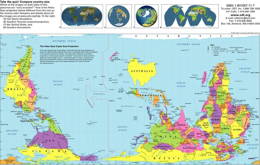
9 9
10 10 Sources and References At least 4 sources of information not including data or graphics At least 2 sources must be scholarly sources such as academic journals or books Wikipedia is not an acceptable source... Websites should be reputable and contain verifiable information (e.g., Huffington Post is OK, answers.yahoo.com is NOT OK)

11 11 How to use Wikipedia

12 12 Why Maps? Reference Spatial analysis Communicating information Synesthetic device


13 13 Absolute Locations Geographic grids are coordinate systems that allow us to locate places on a map Latitude-Longitude N, W , Metes and Bounds Township and Range


14 14 Coordinate Systems Source: Fiona Vincent

15 15 Time Zones and Longitude
16 16 Map Projections: Flattening a Globe
 vs.")
17 17 Map Projections: Equal-area (equivalent) vs. Conformal
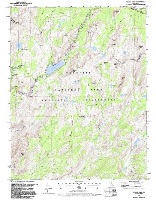
18 18 Map Projections
19 19

20 20 Coordinate Systems Source: USGS
21 21 Relative Information & Maps Distance-relationships are never entirely accurate on flat maps because flattening a map causes linear distortion Maps tend to be most accurate with regard to distance near the center of the projection and least accurate at the edges Relationships between places can be expressed in different ways

22 22 Map Symbology Points and Lines Isolines and Contours Areas Flows

23 23 Map Symbology Points and Lines Isolines and Contours Areas Flows

24 24 Map Symbology Points and Lines Isolines and Contours Areas (choropleth map) Flows

25 25 Map Symbology Points and Lines Isolines and Contours Areas Flows

26 26 Map Scale Large scale: more detail Scale ratio is larger Small scale: less detail Scale ratio is smaller 1:10,000,000 vs 1:10,000

27 Temperature Anomaly (NASA) Small scale map Source: Third World Atlas by Alan Thomas

28 28 Large scale map Source: Keith Miyake for North Star Fund

29 29 Types of Maps: Choropleth Source:

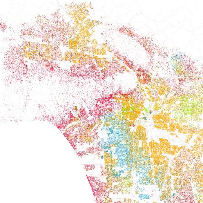
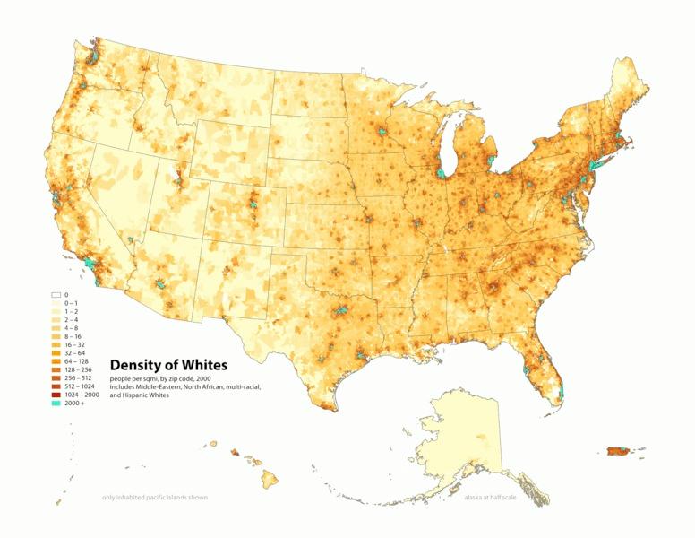
30 30 Carbon Emissions by Country Types of Maps: Area Cartogram Source:

31 31 Maps and Technology Sensing and imagery GPS and locational devices GIS and computers The Internet Creative uses of existing technologies Source:

32 32 Remote Sensing
 False-color image; oil is blueblack, delta waters are reddish, land is")
33 33 Remote Sensing Imagery of the Gulf of Mexico taken by NASA's Terra spacecraft (left) Near true-color image of Mississippi Delta (right) False-color image; oil is blueblack, delta waters are reddish, land is cyan

34 34 Remote Sensing and Internet Technologies
 and Spatial")
35 35 Geographic Information Science (GISc) and Spatial Analysis

36 36 Spatial Analysis
37 37 John Snow, Cholera, Epidemiology 1800s cholera widely believed to be caused by miasma (pollution or bad air) 1849 Snow published: "On the Mode of Communication of Cholera" where he proposed that the "Cholera Poison" reproduced in the human body and was spread through contaminated food or water. Theory unproven until London in 1854 Snow identified pattern of deaths surrounding a water pump on Broad St. Removal of pump handle coincided with reduction in deaths

38 38 Spatial Analysis: Environmental Racism
39 39
40 40 How to Lie with Maps Map standardization Who is making the maps and why? What social and psychological effects might standardization cause? People trust maps! Maps imply factuality and impartiality
41 41 How to Lie with Maps Scale (size of different things, relative to what?) Omission Distortion Symbology How data are represented (e.g., density vs. population vs. per capita) Implications?
42 42
43 43
44 44
45 45
46 46 Gallery Walk What is the map style or category? What information is being conveyed? Who is the audience? What is the scale and scope of the map? Would the map be effective at different scales? What layers and symbology are used? Is the map effective? Thinking about the range of information that can be conveyed through maps, what are some commonalities that all maps share?
Chapter 02 Maps. Multiple Choice Questions
 Chapter 02 Maps Multiple Choice Questions 1. Every projection has some degree of distortion because A. a curved surface cannot be represented on a flat surface without distortion. B. parallels and meridians
Advanced Placement Human Geography
 Advanced Placement Human Geography Introduction to AP Human Geography The Advanced Placement course in Human Geography is designed to introduce students to the systematic study of the processes that have
AP Human Geography Chapter 1: Thinking Geographically Key Issue 1: How do Geographers describe where things are?
 AP Human Geography Chapter 1: Thinking Geographically Key Issue 1: How do Geographers describe where things are? Studying Human Geography Physical Geography Physical geography deals with Earth s natural
INDIANA ACADEMIC STANDARDS FOR SOCIAL STUDIES, WORLD GEOGRAPHY. PAGE(S) WHERE TAUGHT (If submission is not a book, cite appropriate location(s))
 WHERE TAUGHT (If submission is not a book, cite appropriate location(s))") Prentice Hall: The Cultural Landscape, An Introduction to Human Geography 2002 Indiana Academic Standards for Social Studies, World Geography (Grades 9-12) STANDARD 1: THE WORLD IN SPATIAL TERMS Students
Prentice Hall: The Cultural Landscape, An Introduction to Human Geography 2002 Indiana Academic Standards for Social Studies, World Geography (Grades 9-12) STANDARD 1: THE WORLD IN SPATIAL TERMS Students
AP Human Geography Unit I: Intro to Geography
 Thinking Geographically: Key Issue 1 What Is Human Geography? De Blij pp. 1 9 1. According to the text, how many people are malnourished in the world? 2. World Hunger Use the map on page 2 3 in your textbook
Grade 6 Social Studies
 Unit Title: Africa : Movement Location Place Human Region : Subject/Course: 6 th Grade Social Studies Essential Questions: peoples, cultures and ideas of the world? How is a location identified using map
Geographical knowledge and understanding scope and sequence: Foundation to Year 10
 Geographical knowledge and understanding scope and sequence: Foundation to Year 10 Foundation Year 1 Year 2 Year 3 Year 4 Year 5 Year 6 Year level focus People live in places Places have distinctive features
5. How has globalization hindered the nation of Kenya?
 Thinking Geographically: Key Issue 1 What Is Human Geography? De Blij pp. 1-9 1. According to the text, how many people are malnourished in the world? 2. World Hunger - Use the map on page 2-3 in your
netw rks Guided Reading Activity Essential Question: How does geography influence the way people live? What Is Geography?
 Guided Reading Activity What Is Geography? Lesson 1 Thinking Like a Geographer Essential Question: How does geography influence the way people live? Directions: Read the lesson and use your textbook to
World Geography. WG.1.1 Explain Earth s grid system and be able to locate places using degrees of latitude and longitude.
 Standard 1: The World in Spatial Terms Students will use maps, globes, atlases, and grid-referenced technologies, such as remote sensing, Geographic Information Systems (GIS), and Global Positioning Systems
Pool Canvas. Add. Creation Settings. Chapter 1--Objectives and Tools of World Regional Geography. Description Instructions.
 1 of 6 TEST BANK > CONTROL PANEL > POOL MANAGER > POOL CANVAS Pool Canvas Add, modify, and remove questions. Select a question type from the Add Question drop-down list and click Go to add questions. Use
Many Ways to Name a Place
 Your web browser (Safari 7) is out of date. For more security, comfort and Activityapply the best experience on this site: Update your browser Ignore Many Ways to Name a Place What are the names for the
Unit of Study: Physical Geography & Settlement Patterns; Culture & Civilizations; and The Spread of Ideas
 6 th Grade Social Studies 1 st Nine Weeks TEKS Unit of Study: Physical Geography & Settlement Patterns; Culture & Civilizations; and The Spread of Ideas 6.1) History. The student understands that historical
Level 1 Geography PROGRAMME OVERVIEW 2014
 Ruawai College Social Sciences Department Level 1 Geography PROGRAMME OVERVIEW 2014 Topic/Theme EXTREME NATURAL EVENTS: TSUNAMIS Case Study: 2004 Indian Ocean Tsunami/Boxin g Day Tsunami, Indian Ocean
Curriculum and Assessment in Geography at KS3
 Curriculum and Assessment in Geography at KS3 Curriculum Statement: Geography The world as we know it is not given and it can and it will change. - Lambert et al. Powerful Knowledge in Geography Geography
Studying Geography: Tools of the Trade
 GEOG 101 TUTORING AVAILABLE Free tutoring is available to all GEOG 101 students by experienced teachers. No appointment is necessary. Walk in/walk out sessions. Bring your notes, textbook, handouts, and
Intro to GIS In Review
 Intro to GIS In Review GIS Analysis Winter 2016 GIS A quarter in review Geographic data types Acquiring GIS data Projections / Coordinate systems Working with attribute tables Data classification Map design
CURRICULUM COURSE OUTLINE
 CURRICULUM COURSE OUTLINE Course Name(s): World Area Studies Grade(s): 9-11 Department: Social Studies Course Length: 1 Semester Pre-requisite: None Textbook/Key Resource: No Primary Textbook Course Description:
Chapter 1: Basic Concepts
 Chapter 1: Basic Concepts The Cultural Landscape: An Introduction to Human Geography Defining Geography Word coined by Eratosthenes Geo = Earth Graphia = writing Geography thus means earth writing Contemporary
Geography. Programme of study for key stage 3 and attainment target (This is an extract from The National Curriculum 2007)
") Geography Programme of study for key stage 3 and attainment target (This is an extract from The National Curriculum 2007) Crown copyright 2007 Qualifications and Curriculum Authority 2007 Curriculum aims
Geography Programme of study for key stage 3 and attainment target (This is an extract from The National Curriculum 2007) Crown copyright 2007 Qualifications and Curriculum Authority 2007 Curriculum aims
Fall 2013 Monday 6:30pm-9:00pm
 History & Methods Geography Fall 2013 Monday 6:30pm-9:00pm Instructor: Dr. Nate Gabriel Email: gabrieln@rowan.edu Course Description This course will cover the history and development of geographic study,
Chapter 1: Basic Concepts
 Chapter 1: Basic Concepts The Cultural Landscape: An Introduction to Human Geography Defining Geography Word coined by Eratosthenes Geo = Earth Graphia = writing Geography thus means earth writing Contemporary
A.P. Human Geography
 A.P. Human Geography 2012-2013 Instructor: Chris Vitt Brief Description of Course AP Human Geography is designed to provide students with a learning experience equivalent to that obtained in most college
May 18, Dear AP Human Geography Student,
 May 18, 2018 Dear AP Human Geography Student, This fall many exciting challenges and opportunities await you in AP Human Geography. As the title indicates, this is a college-level course. Its format follows
Ch. 1: Icebreaker Step 1 Think of a place in the world you are familiar with and write that place down in your notebook (Ex: St.
 Ch. 1: Icebreaker Step 1 Think of a place in the world you are familiar with and write that place down in your notebook (Ex: St. Louis) Step 2 Pretend someone has no clue where your referring to, describe
Book Review: A Social Atlas of Europe
 Book Review: A Social Atlas of Europe Ferreira, J Author post-print (accepted) deposited by Coventry University s Repository Original citation & hyperlink: Ferreira, J 2015, 'Book Review: A Social Atlas
1. Define map: 2. Name and define the five concepts that guide geographers a) 3. Define cartography: MAPS 4. A map serves two purposes a)
 3. Define cartography: MAPS 4. A map serves two purposes a)") 1. Define map: 2. Name and define the five concepts that guide geographers c) d) e) 3. Define cartography: MAPS 4. A map serves two purposes 5. Give two examples of early mapmaking and its (unusual?) materials
1. Define map: 2. Name and define the five concepts that guide geographers c) d) e) 3. Define cartography: MAPS 4. A map serves two purposes 5. Give two examples of early mapmaking and its (unusual?) materials
Grade 3 Social Studies
 Grade 3 Social Studies Social Studies Grade(s) 3rd Course Overview This course focuses on the five Wisconsin Model Academic standards for Social Studies: Geography, History, Political Science and Citizenship,
The Arctic Ocean. Grade Level: This lesson is appropriate for students in Grades K-5. Time Required: Two class periods for this lesson
 The Arctic Ocean Lesson Overview: This lesson will introduce students to the Eastern Arctic Region and the benefits of the Arctic Ocean to the people who live in the Far North. This lesson can be modified
GIST 4302/5302: Spatial Analysis and Modeling Lecture 1: Overview
 GIST 4302/5302: Spatial Analysis and Modeling Lecture 1: Overview Guofeng Cao www.myweb.ttu.edu/gucao Department of Geosciences Texas Tech University guofeng.cao@ttu.edu Fall 2017 Texas Tech GIS Graduate
AP Human Geography Syllabus
 AP Human Geography Syllabus Textbook The Cultural Landscape: An Introduction to Human Geography. Rubenstein, James M. 10 th Edition. Upper Saddle River, N.J.: Prentice Hall 2010 Course Objectives This
CHAPTER 1: KEY ISSUE 1 How Do Geographers Describe Where Things Are? p. 4-13
 CHAPTER 1: KEY ISSUE 1 How Do Geographers Describe Where Things Are? p. 4-13 Always keep your vocabulary packet out whenever you take notes. As the term comes up in the text, add to your examples for the
Switching to AQA from Edexcel: Draft Geography AS and A-level (teaching from September 2016)
") Switching to AQA from Edexcel: Draft Geography AS and A-level (teaching from September 2016) If you are thinking of switching from OCR to AQA (from September 2016), this resource is an easy reference guide.
Switching to AQA from Edexcel: Draft Geography AS and A-level (teaching from September 2016) If you are thinking of switching from OCR to AQA (from September 2016), this resource is an easy reference guide.
Your web browser (Safari 7) is out of date. For more security, comfort and. the best experience on this site: Update your browser Ignore
 is out of date. For more security, comfort and. the best experience on this site: Update your browser Ignore") Your web browser (Safari 7) is out of date. For more security, comfort and Activitydevelop the best experience on this site: Update your browser Ignore Places in the Park Why do we use symbols? Overview
Your web browser (Safari 7) is out of date. For more security, comfort and Activitydevelop the best experience on this site: Update your browser Ignore Places in the Park Why do we use symbols? Overview
INFS 321 Information Sources
 INFS 321 Information Sources Session 7 Geographical Sources Lecturer: Prof. Perpetua S. Dadzie, DIS Contact Information: pdadzie@ug.edu.gh College of Education School of Continuing and Distance Education
Introduction to Geographic Information Science. Updates/News. Last Lecture 1/23/2017. Geography 4103 / Spatial Data Representations
 Geography 4103 / 5103 Introduction to Geographic Information Science Spatial Data Representations Updates/News Waitlisted students First graded lab this week: skills learning Instructional labs vs. independence
Mapping Earth. How are Earth s surface features measured and modeled?
 Name Mapping Earth How are Earth s surface features measured and modeled? Before You Read Before you read the chapter, think about what you know about maps Record your thoughts in the first column Pair
AAG CENTER FOR GLOBAL GEOGRAPHY EDUCATION Internationalizing the Teaching and Learning of Geography
 Using the CGGE Materials in Advanced Placement Human Geography Classes About the CGGE: The AAG Center for Global Geography Education (CGGE) is a collection of online modules for undergraduate courses in
Belfairs Academy GEOGRAPHY Fundamentals Map
 YEAR 12 Fundamentals Unit 1 Contemporary Urban Places Urbanisation Urbanisation and its importance in human affairs. Global patterns of urbanisation since 1945. Urbanisation, suburbanisation, counter-urbanisation,
Wayne E. Sirmon GEO 301 World Regional Geography
 Wayne E. Sirmon GEO 301 Geography 301 Geography 301 MAP: A graphic representation of a portion of the earth s surface dawn to scale, as seen from above. Types of Maps Climate maps give general information
Key Issue 1: How Do Geographers Describe Where Things Are?
 Key Issue 1: How Do Geographers Describe Where Things Are? Pages 5-13 and some information from pages 15-18. ***Always keep your key term packet out whenever you take notes from Rubenstein. As the terms
Instructor s Manual to accompany Introduction to Geography, 13/e by Getis/Getis/Bjelland/Fellmann
 Instructor s Manual to accompany Introduction to Geography, 13/e by Getis/Getis/Bjelland/Fellmann CHAPTER 1: INTRODUCTION Chapter Summary Geography is the study of how and why things differ from place
Unit 1 All. Study online at quizlet.com/_3l51hr
 Unit 1 All Study online at quizlet.com/_3l51hr 1. geography: 4. 7 APHG Units+: The study of the distribution and interaction of physical and human features on the earth 2. physical geography: 1. Geography:
The World of Geography Pre-Test/Study Guide Chapter 1 Test
 Read each statement or question. On the lines below write the letter of the best answer. 1. Geographers look at the Earth 5. What are the two specific A. by studying cities first. measurements of Earth
Your web browser (Safari 7) is out of date. For more security, comfort and. the best experience on this site: Update your browser Ignore
 is out of date. For more security, comfort and. the best experience on this site: Update your browser Ignore") Your web browser (Safari 7) is out of date. For more security, comfort and lesson the best experience on this site: Update your browser Ignore Political Borders Why are the borders of countries located
Your web browser (Safari 7) is out of date. For more security, comfort and lesson the best experience on this site: Update your browser Ignore Political Borders Why are the borders of countries located
AP Human Geography. Basic Concepts
 AP Human Geography Basic Concepts An in-depth Social Science Many people have misconceptions about geography and think of the discipline as simply an exercise in memorizing place names. Where we find Geography?
Course Introduction II
 CULTURE GEOG 247 Cultural Geography Course Introduction II Prof. Anthony Grande Hunter College-CUNY AFG 2015 Culture is the essence of human geography because it influences all aspects of life on earth.
Chapter 1 Learning Guide Thinking Geographically
 Chapter 1 Learning Guide Thinking Geographically Key Issue 1 How Do Geographers Address Where Things Are? Pgs. 2 13 1. Define map: 2. Define cartography: Maps 3. Give an example of early mapmaking and
AP HuG Summer
 AP HuG Summer 2017-2018 Welcome to AP Human Geography! I look forward to having you in class next year. For many of you an AP class is a new concept, and you may be wondering what AP entails. An AP course
GIS FOR PLANNING. Course Overview. Schedule. Instructor. Prerequisites. Urban Planning 792 Thursday s 5:30-8:10pm SARUP 158
 GIS FOR PLANNING Urban Planning 792 Thursday s 5:30-8:10pm SARUP 158 Schedule Class/Lab - SARUP 158 Thursdays 5:30pm - 8:10pm Office Hours - By Appointment Project Ideas - Week 4 Final - 5/10/2018 Instructor
GED 554 IT & GIS. Lecture 6 Exercise 5. May 10, 2013
 GED 554 IT & GIS Lecture 6 Exercise 5 May 10, 2013 Free GIS data sources ******************* Mapping numerical data & Symbolization ******************* Exercise: Making maps for presentation GIS DATA SOFTWARE
Geography General Course Year 12. Selected Unit 3 syllabus content for the. Externally set task 2019
 Geography General Course Year 12 Selected Unit 3 syllabus content for the Externally set task 2019 This document is an extract from the Geography General Course Year 12 syllabus, featuring all of the content
Climate Change: How it impacts Canadians and what we can do to slow it down.
 Climate Change: How it impacts Canadians and what we can do to slow it down. Lesson Overview This lesson takes stock of how climate change has already affected Canadians in geographic, economic, and cultural
International Court of Justice World Trade Organization Migration and its affects How & why people change the environment
 Social Issues Unit 2 Population Grade 9 Time for Completion: 12 class period State Standard: The student uses a working knowledge and understanding of the spatial organization of Earth s surface and relationships
ANSWER KEY GEOGRAPHIC ISSUES OF THE 21ST CENTURY
 page 1 / 5 page 2 / 5 answer key geographic issues pdf 1- is finding the most cost-effective media to deliver the desired number and type of exposures to the target audience. Copy testing Content analysis
Seymour Centre 2017 Education Program 2071 CURRICULUM LINKS
 Suitable for: Stage 5 Stage 6 HSC Subject Links: Seymour Centre 2017 Education Program 2071 CURRICULUM LINKS Science Stage Content Objective Outcomes Stage 5 Earth and Space ES3: People use scientific
1 st Six Weeks # of Days. Unit # and Title Unit 1 Geography Overview
 1 st Six Weeks # of Days Unit # and Title Unit 1 Geography Overview Orange Grove ISD Instructional Planning Information and Process Standards The Process Standards Must Be Included in Each Unit # of Class
Map Skills and Geographic Tools
 Name: Period: Map Skills and Geographic Tools TEKS: 8.9C interpret topographic maps and satellite views to identify land and erosional features and predict how these features may be reshaped by weathering
TEMPLATE FOR CMaP PROJECT
 TEMPLATE FOR CMaP PROJECT Project Title: Native Utah Plants Created by: Anna Davis Class: Box Elder 2008 Project Description Community Issue or Problem Selected -How project evolved? Community Partner(s)
Subject: Geography Scheme of Work: B1 to B6 Mastery tiles. Term: Autumn/Spring/Summer
 Subject: Geography Scheme of Work: B1 to B6 Mastery tiles Term: Autumn/Spring/Summer Topic / Unit(s) Overview / Context Introduction to geography. An introduction to geography including basic map skills
Geography. Geography A. Curriculum Planner and Skills Mapping Grid GCSE Version 1 October 2012
 Geography GCSE 2012 Geography A Curriculum Planner and Skills Mapping Grid Version 1 October 2012 www.ocr.org.uk/gcse2012 Year 10 Exam work Controlled Assessment Autumn 1 Autumn 2 Spring 1 Spring 2 Summer
EXTRA CREDIT Extra Credit Atlas Exercise for Exam I is available on the course home page
 EXTRA CREDIT Extra Credit Atlas Exercise for Exam I is available on the course home page. Submit answers to me using the blue Scantron sheet by Feb. 19, 2019. Once you have completed the exercise, transfer
Key Issue 1: How Do Geographers Describe Where Things Are?
 Key Issue 1: How Do Geographers Describe Where Things Are? Pages 5-13 ***Always keep your key term packet out whenever you take notes from Rubenstein. As the terms come up in the text, think through the
9/7/ Studying Geography: Introduction to Mapping. Cartographic Terms. Cartographic Terms. Geographers Tools. Geographers Needs.
 Geographers Tools Studying Geography: Introduction to Mapping Prof. Anthony Grande Hunter College Geography Lecture design, content and presentation AFG0918. Individual images and illustrations may be
Unit I Terms. 1.1 Terms
 Unit I Terms 1.1 Terms Space Def: area Sig: space, or spatial analysis, is at the heart of geography (like time is to historians) Projection Def: The system used to transfer locations from earth s surface
Assessment Design. AGTA Conference Rotorua NZ January 2015
 Assessment Design AGTA Conference Rotorua NZ January 2015 The StAR team Standards, Assessment and Reporting How do we know? Assessment Urban settlement 1. List 3 advantages of living in your local town
An Introduction to the South Carolina Atlas
 An Introduction to the South Carolina Atlas Daniel E. Stone Pinewood Preparatory School dstone@pinewoodprep.com Overview This lesson is designed to serve as an introduction to the new South Carolina Atlas.
Academic Standards for Geography
 Academic Standards for June 1, 2009 FINAL Elementary Standards Grades 3-8 Pennsylvania Department of Education These standards are offered as a voluntary resource for Pennsylvania s schools and await action
I. Course Description:
 Advanced Placement Human Geography St. Paul Preparatory School Teacher: Kyle Tredinnick Meeting Time: Block 2 A Days 10:03-11:28 Room Number: 124 Telephone: 651-288-4606 ext.7124 E-mail address: KTredinnick@stpaulprep.org
Moreton Bay and Key Geographic Concepts Worksheet
 Moreton Bay and Key Geographic Concepts Worksheet The Australian Curriculum: Geography draws on seven key geographic concepts: place scale space environment change interconnection sustainability They are
I. Course Description:
 Advanced Placement Human Geography St. Paul Preparatory School Teacher: Kyle Tredinnick Meeting Time: B Day Block 1 B Day Block 2 Room Number: 124 Telephone: 651-288-4606 ext.7124 E-mail address: KTredinnick@stpaulprep.org
STAG LANE JUNIOR SCHOOL GEOGRAPHY POLICY
 Status-Recommended Prepared by: Megha Visavadia Date written January 2017 Shared with staff: Spring 2017 STAG LANE JUNIOR SCHOOL GEOGRAPHY POLICY Shared with governors: Spring 2018 Date for review: July
What is Geography? Lecture 1 The Earth As A Rotating Planet. What is Geography? What is geography? Subfields of Geography?
 Lecture 1 The Earth As A Rotating Planet Geog210 Physical Geography What is Geography? Much more than place names and locations The study of spatial variation How and why things differ from place to place
GEOG People and their Environment Section 01 Spring 2015 Monday and Thursday 1:10 pm to 2:25 pm Hunter West 511
 GEOG. 101- People and their Environment Section 01 Spring 2015 Monday and Thursday 1:10 pm to 2:25 pm Hunter West 511 Dr Mohamed B. Ibrahim Office: Hunter North 1048 Tel. 772-5267 mibrahim@hunter.cuny.edu
GTECH 380/722 Analytical and Computer Cartography Hunter College, CUNY Department of Geography
 GTECH 380/722 Analytical and Computer Cartography Hunter College, CUNY Department of Geography Fall 2014 Mondays 5:35PM to 9:15PM Instructor: Doug Williamson, PhD Email: Douglas.Williamson@hunter.cuny.edu
Sample assessment task. Task details. Content description. Year level 1
 Sample assessment task Year level 1 Learning area Subject Title of task Task details of task Type of assessment Purpose of assessment Assessment strategy Evidence to be collected Suggested time Content
Early College High School PreAP World Geography Summer Reading Assignment
 Early College High School PreAP World Geography Summer Reading Assignment In preparation for your studies in World Geography you will be familiarizing yourself with the 5 Themes of Geography. This assignment
Subject: Geography- Grade Descriptors
 Subject Grade s Developing - Secure This is the Grade at that level = 9 There are no s for 9 Exceptional ly in the top 20% at 8 is awarded 9 8 for 8 securely at 8 showing of AO1, A02 AO3 Excellent knowledge
Key Issue 1: How Do Geographers Describe Where Things Are?
 Key Issue 1: How Do Geographers Describe Where Things Are? Pages 5-13 ***Always keep your key term packet out whenever you take notes from Rubenstein. As the terms come up in the text, think through the
Intro to GIS Summer 2012 Data Visualization
 Intro to GIS Summer 2012 Data Visualization UNDERSTANDING YOUR MAP DATA Qualitative vs. Quantitative Data Qualitative Data classified by category e.g. Soil types, Animal Species Quantitative Data grouped
4 Studying Geography:
 4 Studying Geography: Introduction to Mapping Prof. Anthony Grande Hunter College Geography Lecture design, content and presentation AFG0119 Individual images and illustrations may be subject to prior
St John s Catholic Primary School. Geography Policy. Mission Statement
 St John s Catholic Primary School Geography Policy Mission Statement We at St John s strive for excellence in education by providing a safe, secure and caring family environment where individuals are valued
A Journey Back in Time
 A Trip Through Geologic Time TEACHER NOTES Lab zonetm A Journey Back in Time The following steps will walk you through the. Use the hints and detailed directions as you guide your students through planning,
Emerging Issues in Geographic Information Science (GEP680): Projections, Scale, Accuracy, and Interpolation Lehman College, Spring 2017
: Projections, Scale, Accuracy, and Interpolation Lehman College, Spring 2017") Emerging Issues in Geographic Information Science (GEP680): Projections, Scale, Accuracy, and Interpolation Lehman College, Spring 2017 Instructor: Gary Ostroff, P.E., Adjunct Lecturer E-mail: Gary.Ostroff@lehman.cuny.edu;
Emerging Issues in Geographic Information Science (GEP680): Projections, Scale, Accuracy, and Interpolation Lehman College, Spring 2017 Instructor: Gary Ostroff, P.E., Adjunct Lecturer E-mail: Gary.Ostroff@lehman.cuny.edu;
DRAWING YOUR CONTINENT
 CONTINENT PROJECT PART I On the attached sheet, you will draw your own continent. Use your creativity to create a continent that is uniquely your own. Give the continent a name. When you are finished with
History and Social Science: Advanced Placement Human Geography
 History and Social Science: Advanced Placement Human Geography A.P. Human Geography Curriculum for Loudoun County Public Schools Ashburn, Virginia 2016 This curriculum document for Advanced Placement Human
3. Give two examples of early mapmaking and its (unusual?) materials for the maps. (a)
 materials for the maps. (a)") Thinking Geographically: Key Issue 1 How Do Geographers Describe Where Things Are? Rubenstein Ch. 1 pp. 4 12 1. Define map: 2. Define cartography: MAPS 3. Give two examples of early mapmaking and its (unusual?)
Thinking Geographically: Key Issue 1 How Do Geographers Describe Where Things Are? Rubenstein Ch. 1 pp. 4 12 1. Define map: 2. Define cartography: MAPS 3. Give two examples of early mapmaking and its (unusual?)
Chapter 1: The World of Geography
 Chapter 1: The World of Geography Chapter 1: What is Geography? *It is the study of our earth; our home. OR *Anything that can be mapped! *Geography mixes up the physical and human aspects of our world
Health and Medical Geography (GEOG 222)
") Spring 2019 Class meets: Tuesdays and Thursdays 12:30-1:45pm Carolina Hall Room 220 Instructor: Michael Emch Email: emch@unc.edu Course Objectives Health and Medical Geography (GEOG 222) This course is
Spring 2019 Class meets: Tuesdays and Thursdays 12:30-1:45pm Carolina Hall Room 220 Instructor: Michael Emch Email: emch@unc.edu Course Objectives Health and Medical Geography (GEOG 222) This course is
Curriculum Unit. Instructional Unit #1
 Curriculum Unit Name of Course: AP Human Geography Grade Level(s): 9-12 Brief Description (Course Catalog): The purpose of the AP Human Geography course is to introduce students to the systematic study
Alleghany County Schools Curriculum Guide GRADE/COURSE: World Geography
 GRADE/COURSE: World 2013-14 GRADING PERIOD: 1 st Six Weeks Time Frame Unit/SOLs SOL # Strand Resource Assessment 8 days* The student will use maps, globes, satellite images, photographs, or diagrams to
World Geography Unit Curriculum Document
 Unit Number and Title: Unit 9-Review (including a comparison to North America) Curriculum Concepts: Globalization Culture Democracy Diversity Migration Enduring Understandings (Big Ideas): Time Frame:
Chapter One. Thinking Geographically
 Chapter One Thinking Geographically Where are you? Tell me where you are. How do you know? Important Terms Map two dimensional or flat scale model of the Earth. Place A specific Point on the Earth s surface.
The Earth's Environment - A Marshy Mystery Stage 2 Geography
 The Earth's Environment - A Marshy Mystery Stage 2 Geography Summary This unit is written for Stage 2 "The Earth's Environment". It is a Geographical Inquiry, enabling students to work through the 3 stages
Understanding China Census Data with GIS By Shuming Bao and Susan Haynie China Data Center, University of Michigan
 Understanding China Census Data with GIS By Shuming Bao and Susan Haynie China Data Center, University of Michigan The Census data for China provides comprehensive demographic and business information
The distribution of human beings in relation to population dynamics, economic development, and cultural diversity.
 Geography104: Introduction to Human Geography SOFI 2011: July 2- August 10 Instructor: Dr. James C. Saku Office Phone: 301-687-4724 Home: 301-687-0519 Administrative Assistant: 301-687-4369 Office Location:
Course Outline. School Name: Keewaytinook Internet High School. Department Name: Canadian and World Studies. Ministry of Education Course Title:
 School Name: Keewaytinook Internet High School Department Name: Canadian and World Studies Course Outline Ministry of Education Course Title: Travel and Tourism: A Geographic Perspective Grade Level: 11
Topic: Fundamentals of Topographic Map (Cartographic Technique) Honors
 Honors") SN Kansagra School Master lesson Plan : Geography Subject Teacher :- Sanjay Nath Topic: Fundamentals of Topographic Map (Cartographic Technique) Honors Materials (Teaching Aids): White board, Audio visual
SN Kansagra School Master lesson Plan : Geography Subject Teacher :- Sanjay Nath Topic: Fundamentals of Topographic Map (Cartographic Technique) Honors Materials (Teaching Aids): White board, Audio visual
State and National Standard Correlations NGS, NCGIA, ESRI, MCHE
 GEOGRAPHIC INFORMATION SYSTEMS (GIS) COURSE DESCRIPTION SS000044 (1 st or 2 nd Sem.) GEOGRAPHIC INFORMATION SYSTEMS (11, 12) ½ Unit Prerequisite: None This course is an introduction to Geographic Information