Weather for the Road: a Mobile Solution
|
|
|
- Reynold Bell
- 6 years ago
- Views:
Transcription

1 Weather for the Road: a Mobile Solution Philippe Tissot & Darius Stephen Conrad Blucher Institute David Fonseca, Hoang Chau, Duc Tran, Laura Pulgarin & Selvy Letlora The Innovation Center Texas A&M University-Corpus Christi Presentation at the January 2015 AMS Annual Conference The Last Mile: Methods and Technologies for Delivering Custom Weather, Water, and Climate Information to Everyone in the World 13 th Conference on Artificial Intelligence, 31 st Conference on Environmental Information Processing Technologies & Special Symposium on Model Postprocessing and Downscaling
2 Outline Motivation/Project Start The app development process Deployment Other similar apps/websites Future Plan Advice? 2
 10-year Percentages 1,311,970 crashes 23% of vehicle crashes 480,338 persons")
 to a highway weather forecast")
3 Motivation/Project Start Weather-Related Crash Statistics (Annual Averages) wet pavement, rain, snow/sleet, icy pavement, snow/slushy pavement, fog, cross winds 10-year Average ( ) 10-year Percentages 1,311,970 crashes 23% of vehicle crashes 480,338 persons injured 20% of crash injuries 6,253 persons killed 17% of crash fatalities Statistics from the US Department of Transportation, Federal Highway Administration From Ship Navigation to Highways From a ship channel navigation app (Transit Time) to a highway weather forecast app 3

4 A large amount of data is available and underutilized including weather predictions Challenge: how to take advantage of this data and make road trips safer


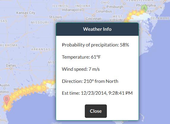
5 How does it work? Google Route Info Enter Trip Information NDFD Weather Data <ns3591:ndfdgen xmlns:ns3591="uri:dwmlgen"> <latitude xsi:type="xsd:string">38.99</latitude> <longitude xsi:type="xsd:string">-77.01</longitude> <product xsi:type="xsd:string">time-series</product> <starttime xsi:type="xsd:string"> T00:00:00</startTime> <endtime xsi:type="xsd:string"> t00:00:00</endtime> <Unit xsi:type="xsd:string">e</unit> <weatherparameters> 5

")


6 Technologies & Data Data Google Maps API, including routing National Weather Service NDFD: XML web service Weather predictions obtained using SOAP (Simple Object Access Protocol) request for locations along the route Technologies Web app built using standard web development technologies, i.e. Javascript, CSS, HTML and jquery mobile Phonegap to wrap the apps, i.e. translation into native mobile apps. Presently for Android devices. Windows, ios upcoming. Allows platform agnostic development. 6


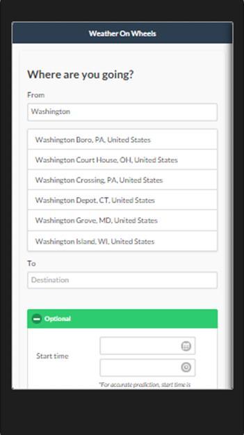
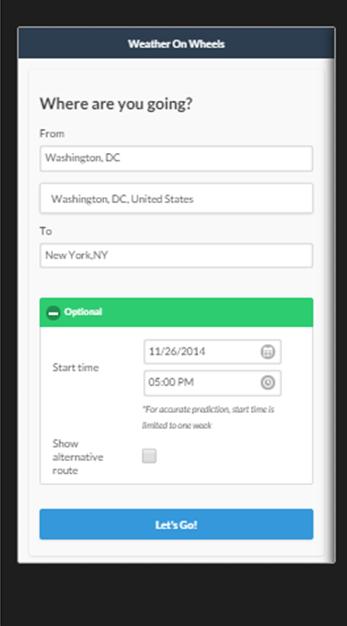

7 Enter Destination Enter Date & Start Time 7


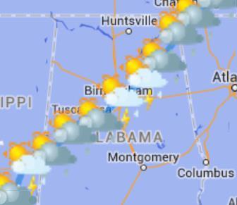
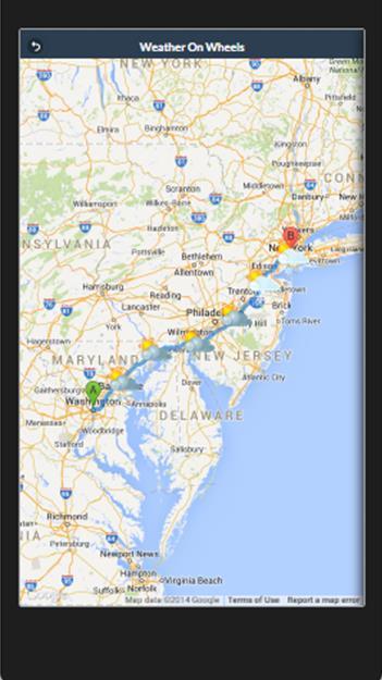
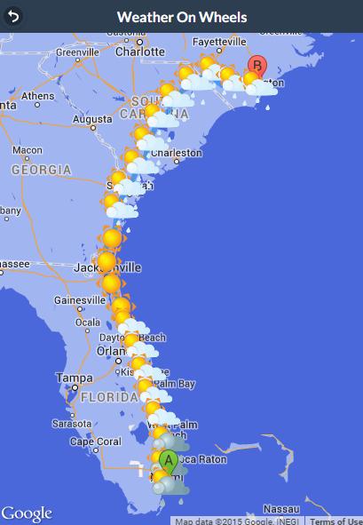
8 Examples Corpus Christi New York: December 24th 8

9 Weather Conditions Examples of selected forecasted weather conditions Icons presently selected for locations based on <weatherconditions> attribute weather-summary and intensity Weather Icons by Weer 9

10 Team Undergraduate Research Assistants from the GIS and Computer Science programs at the Conrad Blucher Institute Graduate assistants from the Business and Arts and Graphics programs at the Innovation Center Joint work included a 1 semester pre-incubation course for technical team, joint grant and regular meetings Other assistance and advices provided by the Texas A&M University-Corpus Christi commercialization office and the TAMU System Commercialization Office 10
 Posts")

 Google Adwords (linked to")

11 Launch Local media (TV, newspaper) Social media (Facebook, Twitter) Posts and tweets related to weather on the road Paid advertising Facebook posts boosts (allow very selective impressions) Google Adwords (linked to search) Twitter (linked to #hashtag) Presently ~ 500 users (350 web/150 app) 17 states 11


12 Other Similar Apps/Services AccuWeather.com The Weather Channel Apps like Weather Tripper, Weather Route, Weather Way, RouteCast Similar in purpose, but not equivalent features 12
13 What s Next? Developing Version 2: fixing bugs and adding features based on user feedback Continue to gather feedback on how to best present/access weather for the road information Add weather alerts for selected road conditions, other information Grow user base Consider long term operation options 13

14 THANK YOU QUESTIONS? - ADVICE Access: weatheronwheelshome.com Acknowledgements: Funding from the Texas Research Development Fund is gratefully acknowledged
Road Weather Management Program
 Road Weather Management Program AASHTO/TRB Joint Maintenance Conference: Highway Safety & Reliability (Winter Maintenance and Highway Safety and Reliability) 7/22/2015 Gabe Guevara. P.E. FHWA Office of
How we use social media to communicate weather news
 How we use social media to communicate weather news The editorial met-team at METNorway WGCEF 12.10.2017 Norwegian Meteorological Institute INSTAGRAM - SHARING PICTURES Weather photos, 2-3 times a week.
Responsive Traffic Management Through Short-Term Weather and Collision Prediction
 Responsive Traffic Management Through Short-Term Weather and Collision Prediction Presenter: Stevanus A. Tjandra, Ph.D. City of Edmonton Office of Traffic Safety (OTS) Co-authors: Yongsheng Chen, Ph.D.,
UDOT Weather Program Traffic Operations Center
 UDOT Weather Program Traffic Operations Center Presentation Goals You MUST account for weather in your Traffic Management program Provide you with information on proven tools and strategies You NEED a
MDSS and Advanced Forecasting STSMO Weather Workshop Dave Huft, SDDOT Research Program Manager September 12, 2017
 Connecting South Dakota and the Nation MDSS and Advanced Forecasting STSMO Weather Workshop Dave Huft, SDDOT Research Program Manager September 12, 2017 1 Weather Impacts & Strategies Winter perceived
10/18/2016 The Hoosier Co. Inc W. 86th Street, Indianapolis, IN
 10/18/2016 The Hoosier Co. Inc. 5421 W. 86th Street, Indianapolis, IN 46268 1 Today s Topics Weather impacts What is RWIS? How old is this tool? Key RWIS Technology/Innovation Key RWIS sensing parameters
Weather Information for Road Managers
 Weather Information for Road Managers by Paul A. Pisano, Lynette C. Goodwin and Andrew D. Stern How Does Weather Affect Roads? The complex interactions between weather and roads have major affects on traffic
WMO. Key Elements of PWS and Effective EWS. Haleh Haleh Kootval Chief, PWS Programme
 WMO Key Elements of PWS and Effective EWS Haleh Haleh Kootval Chief, PWS Programme Workshop Objectives This workshop is all about Service Delivery and becoming excellent at it through: Sharing experiences
Commercialisation. Lessons learned from Dutch weather market
 Commercialisation Lessons learned from Dutch weather market Where information comes together weather traffic public transport Weather, traffic and public transport. Daily actual information that influences
GIS Workshop Data Collection Techniques
 GIS Workshop Data Collection Techniques NOFNEC Conference 2016 Presented by: Matawa First Nations Management Jennifer Duncan and Charlene Wagenaar, Geomatics Technicians, Four Rivers Department QA #: FRG
Application of WebGIS and VGI for Community Based Resources Inventory. Jihn-Fa Jan Department of Land Economics National Chengchi University
 Application of WebGIS and VGI for Community Based Resources Inventory Jihn-Fa Jan Department of Land Economics National Chengchi University OUTLINE Introduction Methodology Results Conclusions 2 MOTIVATION
Evaluating e-government : implementing GIS services in Municipality
 Evaluating e-government : implementing GIS services in Municipality Municipality of Thessaloniki - G.I.S. Unit Misirloglou Symeon Head of the GIS Unit ESRI UC - 2016 The GIS Section - subset of the department
Western States Rural Transportation Consortium Meeting. June 14, 2011
 Western States Rural Transportation Consortium Meeting June 14, 2011 1 Overview/Agenda Welcome / Introductions / Recent ITS Activities General Status of the WSRTC Clarus One Stop Shop Update Year 1 Incubator
The Kentucky Mesonet: Entering a New Phase
 The Kentucky Mesonet: Entering a New Phase Stuart A. Foster State Climatologist Kentucky Climate Center Western Kentucky University KCJEA Winter Conference Lexington, Kentucky February 9, 2017 Kentucky
Weather Information for Surface Transportation (WIST): Update on Weather Impacts and WIST Progress
: Update on Weather Impacts and WIST Progress") Weather Information for Surface Transportation (WIST): Update on Weather Impacts and WIST Progress Samuel P. Williamson Office of the Federal Coordinator for Meteorological Services and Supporting Research
Weather Information for Surface Transportation (WIST): Update on Weather Impacts and WIST Progress Samuel P. Williamson Office of the Federal Coordinator for Meteorological Services and Supporting Research
National Rural ITS Conference 2006
 National Rural ITS Conference 2006 Design of Automated Variable Speed Limits and Lane Assignments in Rural Areas Presented by: Tom Blaine P. E., POE New Mexico Department of Transportation Intelligent
MUNICIPALITY OF ANCHORAGE PUBLIC TRANSPORTATION DEPARTMENT AnchorRIDES TRANSPORTATION SYSTEM
 Purpose: The Public Transportation Department and contracted provider will provide safe transportation for AnchorRIDES customers and employees during severe weather or emergency conditions. AnchorRIDES
SpyMeSat Mobile App. Imaging Satellite Awareness & Access
 SpyMeSat Mobile App Imaging Satellite Awareness & Access Imaging & Geospatical Technology Forum ASPRS Annual Conference March 12-16, 2017 Baltimore, MD Ella C. Herz 1 Orbit Logic specializes in software
Enterprise Linear Referencing at the NYS Department of Transportation
 Enterprise Linear Referencing at the NYS Department of Transportation One Highway Network to Support Many Business Processes May 9, 2018 May 9, 2018 2 Agenda An overview of Linear Referencing How NYSDOT
Snow Response in an Urban Setting
 Snow Response in an Urban Setting Pat Kennedy, PE Denver Street Maintenance Road and Street Supervisors Conference October 15, 2013 Yakima, WA 2 Denver Agenda Population ~600,000 Metropolitan area 2.5
Weather Responsive Traffic Management. Wyoming DOT Variable Speed Limit (VSL) Project. March 2012
 Project. March 2012") Weather Responsive Traffic Management Wyoming DOT Variable Speed Limit (VSL) Project March 2012 I-80 Background Information >50% of I-80 traffic in Wyoming is commercial vehicles Rural AADT 11,000 vehicles
Weather Responsive Traffic Management Wyoming DOT Variable Speed Limit (VSL) Project March 2012 I-80 Background Information >50% of I-80 traffic in Wyoming is commercial vehicles Rural AADT 11,000 vehicles
Dust Storms in Arizona: The Challenge to Ensure Motorist Safety Jennifer Toth, P.E. Deputy Director for Transportation
 Dust Storms in Arizona: The Challenge to Ensure Motorist Safety Jennifer Toth, P.E. Deputy Director for Transportation Arizona Department of Transportation AASHTO Extreme Weather Event Symposium May 21,
Plow Camera and Location Sharing Practices. National Rural ITS Conference October 23, 2018
 Plow Camera and Location Sharing Practices National Rural ITS Conference October 23, 2018 Outline NWP Program Overview Project Background Purpose What we did State Summaries ID, MT, ND, MN, IA, PA Project
What is 511? Need for 511 Services. Development & Deployment of Regional Road and Weather Information Supporting 511 Traveler Services
 Development & Deployment of Regional Road and Weather Information Supporting 511 Traveler Services Leon F. Osborne University of North Dakota Regional Weather Information Center Grand Forks, ND David L.
ESRI Delivering geographic information systems to millions of users
 Using Web GIS to Track Government Spending and Performance Eric Floss - ESRI April 12, 2010 ESRI Delivering geographic information systems to millions of users GIS Is Changing Everything How We Reason
NOAA Surface Weather Program
 NOAA Surface Weather Program Maintenance Decision Support System Stakeholder Meeting #9 Jim O Sullivan NOAA Surface Weather Program Manager NWS Office of Climate, Water, and Weather Services September
Data Aggregation with InfraWorks and ArcGIS for Visualization, Analysis, and Planning
 CI125230 Data Aggregation with InfraWorks and ArcGIS for Visualization, Analysis, and Planning Stephen Brockwell Brockwell IT Consulting Inc. Sean Kinahan Brockwell IT Consulting Inc. Learning Objectives
Deploying the Winter Maintenance Support System (MDSS) in Iowa
 in Iowa") Deploying the Winter Maintenance Support System (MDSS) in Iowa Dennis A. Kroeger Center for Transportation Research and Education Iowa State University Ames, IA 50010-8632 kroeger@iastate.edu Dennis Burkheimer
Deploying the Winter Maintenance Support System (MDSS) in Iowa Dennis A. Kroeger Center for Transportation Research and Education Iowa State University Ames, IA 50010-8632 kroeger@iastate.edu Dennis Burkheimer
Delivering Met to the Military User
 Delivering Met to the Military User Andy Kirkman Met Office Defence Business Manager ECMWF MOS Workshop - November 2007 Crown copyright 2006 Page 1 Delivering Met to the Military User This Presentation
Sharing GIS to Empower the End User David Wray, Roanoke County, Virginia
 Sharing GIS to Empower the End User David Wray, Roanoke County, Virginia Sharing GIS to Empower the End User Roanoke County, Virginia Roanoke County, Virginia Population: 92,901 Area: 251 Square Miles
Center for Transportation Research and Education. Winter Maintenance Operations & Maintenance Decision Support System TRANS 691 Seminar March 5, 2004
 Center for Transportation Research and Education Winter Maintenance Operations & Maintenance Decision Support System TRANS 691 Seminar March 5, 2004 1 Why Winter Maintenance? Weather related traffic accidents
DEVELOPMENT OF A VISUALIZATION SYSTEM FOR SafetyAnalyst
 1 2 3 4 5 6 7 8 9 10 11 12 13 14 15 16 17 18 19 20 21 22 23 24 25 26 27 28 29 30 31 32 33 34 35 36 37 38 39 40 41 42 43 DEVELOPMENT OF A VISUALIZATION SYSTEM FOR SafetyAnalyst Alexander Paz, Ph.D., P.E.
WeatherCloud Hyper-Local Global Forecasting All rights reserved. Fathym, Inc.
 WeatherCloud Hyper-Local Global Forecasting based on current forecast techniques EVOLVING FORECASTING TECHNOLOGY 1) The WeatherCloud backend forecast system allows for routing around hazardous weather
NWS Resources For School Districts
 NWS Resources For School Districts January 23rd, 2017 Shawn DeVinny shawn.devinny@noaa.gov Meteorologist National Weather Service Twin Cities/Chanhassen, MN Outline Watches/Warnings/Advisories Example
MUNICIPALITY OF ANCHORAGE PUBLIC TRANSPORTATION DEPARTMENT AnchorRIDES PARATRANSIT SYSTEM
 Purpose: The Public Transportation Department (PTD) and AnchorRIDES paratransit contractor will provide transportation in as safe a manner as effectively possible. Paratransit vehicles primarily operate
MeteoGroup RoadMaster. The world s leading winter road weather solution
 MeteoGroup RoadMaster The world s leading winter road weather solution Discover why RoadMaster is the world s leading winter road weather solution. Managing winter road maintenance means that you carry
NWS Resources For Public Works
 NWS Resources For Public Works August 28th, 2016 Shawn DeVinny shawn.devinny@noaa.gov Meteorologist National Weather Service Twin Cities/Chanhassen, MN 1 APWA 2016 PWX 8/28/2016 National Weather Service
CLIMATE CHANGE ADAPTATION BY MEANS OF PUBLIC PRIVATE PARTNERSHIP TO ESTABLISH EARLY WARNING SYSTEM
 CLIMATE CHANGE ADAPTATION BY MEANS OF PUBLIC PRIVATE PARTNERSHIP TO ESTABLISH EARLY WARNING SYSTEM By: Dr Mamadou Lamine BAH, National Director Direction Nationale de la Meteorologie (DNM), Guinea President,
PHOENIZ, ARIZONA USA, SEPTEMBER 10, 2018 In keeping with a long tradition
 PROTECTING PEOPLE AND ASSETS FOR IMMEDIATE RELEASE Phoenix, Arizona, September 10, 2018 Enterprise Electronics Corporation (EEC) Wins Contract to Deliver Weather Radar System for Dust Detection and Warning
Telecommunication Services Engineering (TSE) Lab. Chapter IX Presence Applications and Services.
 Lab. Chapter IX Presence Applications and Services.") Chapter IX Presence Applications and Services http://users.encs.concordia.ca/~glitho/ Outline 1. Basics 2. Interoperability 3. Presence service in clouds Basics 1 - IETF abstract model 2 - An example of
Chapter IX Presence Applications and Services http://users.encs.concordia.ca/~glitho/ Outline 1. Basics 2. Interoperability 3. Presence service in clouds Basics 1 - IETF abstract model 2 - An example of
10/18/2016 The Hoosier Co. Inc W. 86th Street, Indianapolis, IN
 10/18/2016 The Hoosier Co. Inc. 5421 W. 86th Street, Indianapolis, IN 46268 1 Agenda What is RWIS? What options are available? Innovation/Improvement in Winter Operations & Maintenance Key RWIS sensing
Meridian Environmental Technology, Inc.
 Meridian Environmental Technology, Inc. Providing Tomorrow s Technology Today Meridian is committed to the support of its clients through advancement of science and technology A National Leader in Road
DEVELOPMENT OF A VISUALIZATION SYSTEM FOR Safety Analyst
 1 2 3 4 5 6 7 8 9 10 11 12 13 14 15 16 17 18 19 20 21 22 23 24 25 26 27 28 29 30 31 32 33 34 35 36 37 38 39 40 41 42 43 44 DEVELOPMENT OF A VISUALIZATION SYSTEM FOR Safety Analyst Alexander Paz, Ph.D.,
Geodatabase Best Practices. Dave Crawford Erik Hoel
 Geodatabase Best Practices Dave Crawford Erik Hoel Geodatabase best practices - outline Geodatabase creation Data ownership Data model Data configuration Geodatabase behaviors Data integrity and validation
Water Data Sharing an Update
 Water Data Sharing an Update By David R. Maidment Leader, CUAHSI Hydrologic Information System Project and Director, Center for Research in Water Resources, University of Texas at Austin Prepared for Subcommittee
The Wind Hazard: Messaging the Wind Threat & Corresponding Potential Impacts
 The Wind Hazard: Messaging the Wind Threat & Corresponding Potential Impacts Scott Spratt Warning Coordination Meteorologist NWS Melbourne, FL David Sharp Science & Operations Officer NWS Melbourne, FL
Twitter s Effectiveness on Blackout Detection during Hurricane Sandy
 Twitter s Effectiveness on Blackout Detection during Hurricane Sandy KJ Lee, Ju-young Shin & Reza Zadeh December, 03. Introduction Hurricane Sandy developed from the Caribbean stroke near Atlantic City,
HISTORY OF GIS AND ESRI
 HISTORY OF GIS AND ESRI First Developed by Dr. Roger Tomlinson in Canada 1960 (CGIS Canadian geographic system) The system was designed to inventory land use and assist in the management of natural resources
The Underutilization of GIS & How to Cure It. Adam Carnow Esri
 The Underutilization of GIS & How to Cure It Adam Carnow Esri What is GIS? A framework to organize, communicate, and understand the science of our world Business Intelligence (BI) is the set of
Why GIS & Why Internet GIS?
 Why GIS & Why Internet GIS? The Internet bandwagon Internet mapping (e.g., MapQuest) Location-based services Real-time navigation (e.g., traffic) Real-time service dispatch Business Intelligence Spatial
CHAPTER 22 GEOGRAPHIC INFORMATION SYSTEMS
 CHAPTER 22 GEOGRAPHIC INFORMATION SYSTEMS PURPOSE: This chapter establishes the administration and use of to improve the quality and accessibility of Department s spatial information and support graphical
ALASKA ITS. Vehicles and Observations in the cloud
 ALASKA ITS Vehicles and Observations in the cloud 1 YOUR PRESENTERS Wilf Nixon, Salt Institute Mark DeVries, Vaisala Dan Schacher, ADOT&PF 2 Today s Agenda A Cloud Based Overview connected and autonomous
PILOT STUDY: PAVEMENT VISUAL CONDITION AND FRICTION AS A PERFORMANCE MEASURE FOR WINTER OPERATIONS
 1 PILOT STUDY: PAVEMENT VISUAL CONDITION AND FRICTION AS A PERFORMANCE MEASURE FOR WINTER OPERATIONS Nishantha Bandara, Ph.D., P.E. Department of Civil Engineering Lawrence Technological University 21000
DEVELOPMENT OF A WINTER MAINTENANCE DECISION SUPPORT SYSTEM. Presentation prepared for the:
 DEVELOPMENT OF A WINTER MAINTENANCE DECISION SUPPORT SYSTEM Steve Arsenault, engineer Ministère des Transports du Québec Presentation prepared for the: October 16 session on Management Systems to Support
Leveraging ArcGIS Online Elevation and Hydrology Services. Steve Kopp, Jian Lange
 Leveraging ArcGIS Online Elevation and Hydrology Services Steve Kopp, Jian Lange Topics An overview of ArcGIS Online Elevation Analysis Using Elevation Analysis Services in ArcGIS for Desktop Using Elevation
Portal for ArcGIS: An Introduction. Catherine Hynes and Derek Law
 Portal for ArcGIS: An Introduction Catherine Hynes and Derek Law Agenda Web GIS pattern Product overview Installation and deployment Configuration options Security options and groups Portal for ArcGIS
STATISTICAL ANALYSIS OF LAW ENFORCEMENT SURVEILLANCE IMPACT ON SAMPLE CONSTRUCTION ZONES IN MISSISSIPPI (Part 1: DESCRIPTIVE)
") STATISTICAL ANALYSIS OF LAW ENFORCEMENT SURVEILLANCE IMPACT ON SAMPLE CONSTRUCTION ZONES IN MISSISSIPPI (Part 1: DESCRIPTIVE) Tulio Sulbaran, Ph.D 1, David Marchman 2 Abstract It is estimated that every
STATISTICAL ANALYSIS OF LAW ENFORCEMENT SURVEILLANCE IMPACT ON SAMPLE CONSTRUCTION ZONES IN MISSISSIPPI (Part 1: DESCRIPTIVE) Tulio Sulbaran, Ph.D 1, David Marchman 2 Abstract It is estimated that every
Active Traffic & Safety Management System for Interstate 77 in Virginia. Chris McDonald, PE VDOT Southwest Regional Operations Director
 Active Traffic & Safety Management System for Interstate 77 in Virginia Chris McDonald, PE VDOT Southwest Regional Operations Director Interstate 77 at Fancy Gap Mountain Mile markers 0-15 Built in late
What are Intelligent Transportation Systems? Major ITS Areas
 Intelligent Transportation Systems in Small Cities and Rural Areas Indiana Road School March 20, 2001 Steven Beningo Federal Highway Administration Midwestern Resource Center What are Intelligent Transportation
The Next Generation of Traffic Management Systems
 AASHTO CTSO ITS Working Group Meeting The Next Generation of Traffic Management Systems What Resources Do Agencies Need & Is There Interest to Collaborate With TRB Technical Committees & Other Groups?
Corporate. Information. Railway Infrastructure Administrator. Year indracompany.com
 geospatial and mobility Corporate Geographic Information System of ADIF Railway Infrastructure Administrator. Year 2009-2010 Corporate Geographic Information System of ADIF ADIF. Spanish Administrator
Web GIS Deployment for Administrators. Vanessa Ramirez Solution Engineer, Natural Resources, Esri
 Web GIS Deployment for Administrators Vanessa Ramirez Solution Engineer, Natural Resources, Esri Agenda Web GIS Concepts Web GIS Deployment Patterns Components of an On-Premises Web GIS Federation of Server
NYS Mesonet Data Access Policy
 NYS Mesonet Data Access Policy The New York State Mesonet is a network of 126 weather stations across the state, with at least one station in every county. Each standard station measures temperature, humidity,
Southern Hancock Snow Day Lessons
 Southern Hancock Snow Day Lessons Parent Information Meeting LINK TO THE PRESENTATION CAN BE FOUND AT www.todaysmeet.com/newpal Conditions for a Snow Day All decisions regarding a snow day will be made
Enhancing The Delivery Of Weather & Climate Information To End-Users. by Meteorological Services Division, NEA, Singapore
 Enhancing The Delivery Of Weather & Climate Information To End-Users by Meteorological Services Division, NEA, Singapore WMO RA V Seminar on Enhancing Service Delivery Kuala Lumpur, Malaysia, 2-6 April
Smart use of Geographic Information System (GIS) platform for delivering weather information and nowcasting services
 platform for delivering weather information and nowcasting services") Smart use of Geographic Information System (GIS) platform for delivering weather information and nowcasting services C. K. Pan Hong Kong Observatory Hong Kong, China It is a world of beauty Source: Image
Smart use of Geographic Information System (GIS) platform for delivering weather information and nowcasting services C. K. Pan Hong Kong Observatory Hong Kong, China It is a world of beauty Source: Image
personal weather station
 personal weather station Master your own climate measurements on your smartphone TRAINING BOOK Pitch The Netatmo Personal Weather Station helps you master your own climate measurements on your smartphone.
ArcGIS is Advancing. Both Contributing and Integrating many new Innovations. IoT. Smart Mapping. Smart Devices Advanced Analytics
 ArcGIS is Advancing IoT Smart Devices Advanced Analytics Smart Mapping Real-Time Faster Computing Web Services Crowdsourcing Sensor Networks Both Contributing and Integrating many new Innovations ArcGIS
You are Building Your Organization s Geographic Knowledge
 You are Building Your Organization s Geographic Knowledge And Increasingly Making it Available Sharing Data Publishing Maps and Geo-Apps Developing Collaborative Approaches Citizens Knowledge Workers Analysts
June 19 Huntsville, Alabama 1
 June 19 Huntsville, Alabama 1 Real-Time Geospatial Data: The Fusion of PI and ArcGIS Enabling Smarter Facilities Management OSIsoft and Esri Mapping and Location Analytics Platform Supporting Your Use
Getting Started with Community Maps
 Esri International User Conference San Diego, California Technical Workshops July 24, 2012 Getting Started with Community Maps Shane Matthews and Tamara Yoder Topics for this Session ArcGIS is a complete
Severe Weather Hazards Are Real
 Severe Weather Hazards Are Real In the past 10 years, more than 40 people have died and dozens more injured as a result of weatherrelated events in Minnesota (not including motor vehicles.) The top severe
A Guideline for Training Patrol Staff Ontario Good Roads Association
 A Guideline for Training Patrol Staff Ontario Good Roads Association A Guideline for Training Patrol Staff Rationale A patroller is required to observe both weather and road conditions either in the field
For Military, Research, Tactical Portable Vehicle Mount Fixed Base
 For Military, Research, Military & Commercial Weather Applications Stations Tactical Portable Vehicle Mount Fixed Base WEATHERPAK Marine Weather Stations for Harsh Environments WEATHERPAK marine weather
ArcGIS Earth for Enterprises DARRON PUSTAM ARCGIS EARTH CHRIS ANDREWS 3D
 ArcGIS Earth for Enterprises DARRON PUSTAM ARCGIS EARTH CHRIS ANDREWS 3D ArcGIS Earth is ArcGIS Earth is a lightweight globe desktop application that helps you explore any part of the world and investigate
: : User Manual: : - 10 December
 : : User Manual: : - 0 December 06 - : : User Manual: : Table of Contents. Map Control. How to move a map. How to zoom in and out a map 4. How to inquire Ocean Currents. How to inquire predicted current
National Weather Service
 National Weather Service Performance and Challenges Warning Systems Kenneth E. Graham Meteorologist-in-Charge New Orleans Busy 2008 Number of Tornadoes Number of Tornado Fatalities *Preliminary So Far
City of Saginaw Right of Way Division Snow and Ice Removal Policy January 18, 2016
 Snow and Ice Removal Policy January 18, 2016 It is the policy of the to provide snowplowing and ice removal services in order to: Provide safe traveling conditions for motorists and pedestrians Assist
National Park Service Safety Management
 National Park Service Safety Management Locating Crashes Spatially from the National Park Service Service-wide Traffic Accident Reporting System (STARS) Database By Daniel Van Gilder Federal Highway Administration
CALIOPE EU: Air Quality
 CALIOPE EU: Air Quality CALIOPE EU air quality forecast application User Guide caliope@bsc.es Version 30/09/2015 TABLE OF CONTENTS 1. Description... 1 2. Installation... 1 3. User Guide... 2 3.1 Air quality
United States Multi-Hazard Early Warning System
 United States Multi-Hazard Early Warning System Saving Lives Through Partnership Lynn Maximuk National Weather Service Director, Central Region Kansas City, Missouri America s s Weather Enterprise: Protecting
Transportation and Road Weather
 Portland State University PDXScholar TREC Friday Seminar Series Transportation Research and Education Center (TREC) 4-18-2014 Transportation and Road Weather Rhonda Young University of Wyoming Let us know
Reimaging GIS: Geographic Information Society. Clint Brown Linda Beale Mark Harrower Esri
 Reimaging GIS: Geographic Information Society Clint Brown Linda Beale Mark Harrower Esri 8 billion = Number of basemap requests per month on AGOL 14,000 = Unique requests per second 12,000 = New Items
USING TECHNOLOGY TO SHARE GIS David Wray, Roanoke County, Virginia
 USING TECHNOLOGY TO SHARE GIS David Wray, Roanoke County, Virginia Using Technology to Share GIS Roanoke County, Virginia Roanoke County, Virginia Population: 92,901 Area: 251 Square Miles Protected Areas:
DIGITAL TWINS W A Z U G D e c e m b e r
 DIGITAL TWINS W A Z U G - 1 3 D e c e m b e r 2 0 1 8 J o h a n H o e k J o h a n. H o e k @ W i n v i s i o n. n l F r a n k v a n H o u t e n F r a n k. v a n H o u t e n @ W i n v i s i o n. n l D E
Assessing the Vulnerability of Tennessee Transportation Assets to Extreme Weather
 Assessing the Vulnerability of Tennessee Transportation Assets to Extreme Weather Dr. Mark Abkowitz, Vanderbilt University 8 th Annual Intermodal Conference Memphis TN October 7, 2014 Requires states to
Maryland Bridges in Black & White. Sharing Archival Photos with the Public Using GIS
 Maryland Bridges in Black & White Sharing Archival Photos with the Public Using GIS Introductions Laurie Goudy Maryland State Highway Administration Assistant Division Chief, Data Services Engineering
Innovation. The Push and Pull at ESRI. September Kevin Daugherty Cadastral/Land Records Industry Solutions Manager
 Innovation The Push and Pull at ESRI September 2004 Kevin Daugherty Cadastral/Land Records Industry Solutions Manager The Push and The Pull The Push is the information technology that drives research and
Complete Weather Intelligence for Public Safety from DTN
 Complete Weather Intelligence for Public Safety from DTN September 2017 White Paper www.dtn.com / 1.800.610.0777 From flooding to tornados to severe winter storms, the threats to public safety from weather-related
Copernicus Overview. Major Emergency Management Conference Athlone 2017
 Copernicus Overview Major Emergency Management Conference Athlone 2017 Copernicus is a European programme implemented by the European Commission. The services address six thematic areas: land, marine,
Maryland Transit Administration (MTA) Bus Accident Mapping and Analysis Application
 Bus Accident Mapping and Analysis Application") Maryland Transit Administration (MTA) Bus Accident Mapping and Analysis Application Ralign Wells, MTA Administrator Bernadette Bridges, MTA Chief Safety Officer Office of Safety, Quality Assurance, and
Maryland Transit Administration (MTA) Bus Accident Mapping and Analysis Application Ralign Wells, MTA Administrator Bernadette Bridges, MTA Chief Safety Officer Office of Safety, Quality Assurance, and
SCAUG Community Maps Building a Living Atlas of the World
 SCAUG Community Maps Building a Living Atlas of the World Mark Stewart Topics: SCAUG ArcGIS Online Overview Community Maps Overview Community Maps Workflow Update Process Utilizing Your Contribution Community
The General Public s Weather Information-Seeking and Decision-Making Behavior during Tornado Outbreaks in the Oklahoma City Metroplex in May 2013
 The General Public s Weather Information-Seeking and Decision-Making Behavior during Tornado Outbreaks in the Oklahoma City Metroplex in May 2013 Chen Ling, Michelle Madison, Jessica Adams, Kevin Warren,
Conceptual study of Web-based PPGIS for Designing Built Environment: Identifying Housing Location Preferences in Littleborough
 Conceptual study of Web-based PPGIS for Designing Built Environment: Identifying Housing Location Preferences in Littleborough Shrabanti Hira *1, S M Labib 1 1 SEED, University of Manchester March 31,
Maryland Transit Administration (MTA) Bus Accident Mapping and Analysis Application
 Bus Accident Mapping and Analysis Application") Maryland Transit Administration (MTA) Bus Accident Mapping and Analysis Application Ralign Wells, MTA Administrator Bernadette Bridges, MTA Chief Safety Officer Office of Safety, Quality Assurance, and
Maryland Transit Administration (MTA) Bus Accident Mapping and Analysis Application Ralign Wells, MTA Administrator Bernadette Bridges, MTA Chief Safety Officer Office of Safety, Quality Assurance, and
State Of Wisconsin. Department of Military Affairs. Division of Emergency Management
 State Of Wisconsin Department of Military Affairs Division of Emergency Management Brian M. Satula Administrator Scott Walker Governor For more information contact: Tod Pritchard Office: 608-242-3324 Cell:
Portal for ArcGIS: An Introduction
 Portal for ArcGIS: An Introduction Derek Law Esri Product Management Esri UC 2014 Technical Workshop Agenda Web GIS pattern Product overview Installation and deployment Security and groups Configuration
Middleborough Elementary
 Middleborough Elementary January 2017 Jamie Basignani, Principal Sharon Fischer, Assistant Principal 313 West Road, Essex, MD 21221 (410) 887-0160 main office (410) 887-0161 fax (410) 887-0471 nurse Dear